Showing 298 items
matching river crossings
-
 Ballarat RSL Sub-Branch Inc.
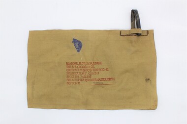
Floatation Bladder, B.F. Goodrich Co, 1939-45
... crossing rivers and streams. The device would have been inserted... crossing rivers and streams. The device would have been inserted ...This floatation bladder was made for survival whilst crossing rivers and streams. The device would have been inserted into clothing and the user would have blown air into the pipe. The pipe would have been folded in half and held in place to prevent air from escaping.Tough rectangular, flat, khaki coloured fabric and rubber bag. There is a rubber pipe at the top, right corner. There is a fabric flap at the base of this pipe which holds the pipe in a bent position. There are also inscriptions on the front/centre of the bag.The following inscriptions are at the front/cente of the bag, printed in red. The very last inscriptions ('M. KNAUSS') are printed in dark purple. 'BLADDER, FLOATATION, JUNGLE' 'THE B.F. GOODRICH CO.' 'CONTRACT W669QM21639 9-30-42' 'SPECIFICATION P.Q.D. 243' 'STOCK NO. 74-B-303' 'PHILADELPHIA QUARTERMASTER DEPOT' 'INSPECTOR______M. KNAUSS_____' floatation bladder, floatation device, world war two, ww2, wwii, second world war -
 Federation University Historical Collection
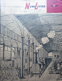
Magazine - Newsletter, Victorian Railways Newsletter, June 1967, 06/1957
... laid with Barlow, or saddle-back rail; cement, Little River... River Station, , Renewing crossings, , memorial to railways ...Soft covered magazine of 16 pages. It includes an article of the Geelong Line centenary, and a photo of the original Geelong line laid with Barlow, or saddle-back rail; cement, Little River Station, , Renewing crossings, , memorial to railways returned servicement at the Ballarat NOrth Workkshops. victorian railwat, geelong railway centenary, cement, cp vans, railcrossings, trains -
 Bendigo Military Museum
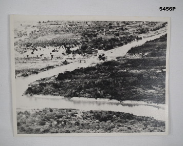
Photograph - PHOTOGRAPH, TAMARAN BRIDGE, British Air Force, C1943-1945
... crossing the river. A bomb ( water and smoke) blast is rising from.... Photo shows flat, uninhibited land. A river (low tide) snakes ...Refer Cat no. 5445.2Photo shows flat, uninhibited land. A river (low tide) snakes through the photo. In the centre is a trestle bridge crossing the river. A bomb ( water and smoke) blast is rising from the side of bridge Photograph rear in ink. “Tamaram bridge" being bombed. Bridge built by POWS. The span was never rebuilt. Trains stopping both sides and goods carried along foot of bridge, on a narrow bridge by POWs.ww2, pow, tamaran bridge, burma railway -
 Tatura Irrigation & Wartime Camps Museum
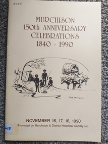
Booklet, Murchison 150th Anniversary Celebrations 1840-1990, 1990
... and bullock team and wagon on front cover and a picture of crossing... and a picture of crossing the river in 1860 on the back cover. 4 black ...Printed as a programme and historical record of the town of Murchison at 150th celebrations in 1990. Cream coloured soft cover, brown printing, aboriginal camp and bullock team and wagon on front cover and a picture of crossing the river in 1860 on the back cover. 4 black and white photographs. 16 pages. Murchison 150th Anniversary 1840 -1990murchison, books, history, 150th celebrations of murchison -
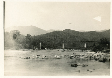 Lakes Entrance Historical Society
Photograph - Bridges
... Cantilever new bridge over Snowy River at McKillops... bridge over Snowy River at McKillops Crossing, 45 feet above ...Black and white photograph showing partially built McKillops Bridge on Snowy River, East Gippsland, Victoria.Cantilever new bridge over Snowy River at McKillops Crossing, 45 feet above recorded flood, washed away before officially opened, decking, etc, down stream more than a mile. (on back)bridges, waterways, topography, construction -
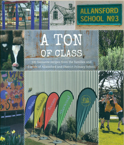 Warrnambool and District Historical Society Inc.
Book, A Ton of Class: 100 favourite recipes from the families and friends of Allansford and District Primary School, 2014
... of 1854 John subdivided a portion of Tooram at the Hopkins River... a portion of Tooram at the Hopkins River crossing known as Allans ...This cookery book was produced in 2014 as a school fundraiser. It was purchased at Allansford Cheese World in January 2015 for $15. Allansford school was established as a National School in 1856 on land reserved for the purpose by John McMahon Allan. It comprised two sandstone classrooms -one for boys and one for girls -with an attached pise teacher's residence. In 1872 when the Victorian Education Department was set up existing schools were listed in alphabetical order and given a number. Allansford State School was No.3. The school was enlarged in the late 1800s and again in the early 1920s. In 1994 following the amalgamation of the Allansford, Allans Forest and Naringal schools a new school was built which adjoined the existing buildings. The old buildings were refurbished as administration and staff facilities. John McMahon Allan settled in the area in 1839 with his brother William Osborne Allan. They were the sons of David Allan, Deputy Commissary General during Macquarie's term of government. The brothers divided the station with William retaining the Allandale portion and John naming his portion Tooram. John McMahon Allan was president of the early district Roads Board. In an attempt to recoup some of the heavy losses due to the disastrous Bateman fire of 1854 John subdivided a portion of Tooram at the Hopkins River crossing known as Allans ford. A school reserve was included in this subdivision. Source: McLeod, Graeme & Barbara. Allansford 1855-2006This book has social and historical interest and significance as it is connected to a local school. It provides a snapshot of food and cooking methods in the early 21st cebturyCookery book with full colour cover featuring 8 photographs and drawings of the Allansford Primary School surrounds and pupil activities on. The images are 'stitched' together with a white zig-zag diamond pattern as if a quilt. The foldout cover has an image of the school's centenary memorial gates and a brief history of the school. Inside the foldout are images of the pupils in each of the school's four team houses. The foldout back cover has full colour images of pupils performing at the school concert. A white strip noting 'our values' is included on the inside back cover foldout. Soft cover, 112 pages.allansford school, a ton of class, allansford primary school, a ton of class recipe book -
 Greensborough Historical Society
Photograph - Digital Image, Marilyn Smith, Plenty River at the aqueduct crossing Greensborough 2019, 02/07/2019
... Plenty River at the aqueduct crossing Greensborough 2019...The Plenty River at the aqueduct crossing, 2019, showing... crossing, 2019, showing graffiti on the river bank rocks ...The Plenty River at the aqueduct crossing, 2019, showing graffiti on the river bank rocks. Originally part of the Maroondah Aqueduct pipeline, all that remains is the bridge that once carried the pipe over the Plenty River. This photograph was taken from the Plenty River Trail in Greensborough. 2 colour digital photographsplenty river trail, maroondah pipetrack, maroondah aqueduct, plenty river, graffiti -
![Photograph - Digital image, Log bridge to Willis Vale [1], 16/10/1903c](/media/collectors/4f729f5697f83e03086015b8/items/54435d6d2162f10ea4a205f1/item-media/54435d962162f10ea4a20821/item-fit-380x285.jpg) Greensborough Historical Society
Greensborough Historical SocietyPhotograph - Digital image, Log bridge to Willis Vale [1], 16/10/1903c
... Photograph shows visitors crossing the river to "Willis... Plenty Lower Plenty melbourne Photograph shows visitors crossing ...Photograph shows visitors crossing the river to "Willis Vale" homestead, home of the Partington family. For many years this log bridge was the quickest way of reaching the Greensborough township from Willis Vale. [Thought to have been taken on or about 16/10/1903 during the funeral week of Ellen Partington.]Digital copy of black and white photograph.willis vale, partington family, plenty river -
![Photograph - Digital image, Log bridge to Willis Vale [2], 16/10/1903c](/media/collectors/4f729f5697f83e03086015b8/items/544360612162f10ea4a21abb/item-media/544360862162f10ea4a21c93/item-fit-380x285.jpg) Greensborough Historical Society
Greensborough Historical SocietyPhotograph - Digital image, Log bridge to Willis Vale [2], 16/10/1903c
... Photograph shows visitors crossing the river to "Willis... Plenty Lower Plenty melbourne Photograph shows visitors crossing ...Photograph shows visitors crossing the river to "Willis Vale" homestead, home of the Partington family. For many years this log bridge was the quickest way of reaching the Greensborough township from Willis Vale. [Thought to have been taken on or about 16/10/1903 during the funeral week of Ellen Partington.]Digital copy of black and white photograph.willis vale, partington family, plenty river -
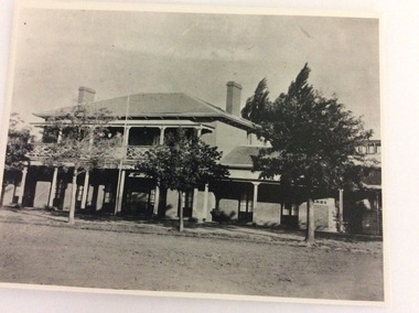 Port of Echuca
A black and white photograph, The Bridge Hotel, in 1896, showing Silky Oak trees, 1970's
... visitors to the town crossing the Murray River on his punt crossing... to the town crossing the Murray River on his punt crossing, which ...The Bridge Hotel was built by Henry Hopwood to house visitors to the town crossing the Murray River on his punt crossing, which was situated just below the Bridge Hotel on the Murray River. The accommodation was spacious and grand! In the right back corner of the photograph, the 'lantern' roof of the St Georges Hall can be seen. The street is level with the front entrance to the Hotel, which is very different to what it is today.The photograph shows hotel activities and accommodation in the late 19th Century.A black and white photograph of the Bridge Hotel taken from the Hopwood Gardens. The photograph shows four silky oak trees growing along the front of the building. There is an empty flag pole outside the front of the building. The right wing advertises billiards, whilst the left wing apparently was a bar.Written on the building can be seen the words; HOTEL and BILLIARDS. Written in pen on the back of the photograph are the words "Bridge Hotel. Probably 1896, showing Silky Oak trees.bridge hotel, henry hopwood, silky oak trees, lantern roof, st georges hotel -
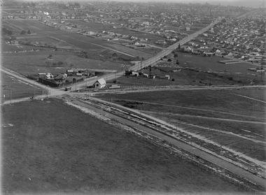 Melbourne Tram Museum
Photograph - Digital Image, Kevin O'Reilly, "Kew Burke Rd' looking at the East Kew Tram terminus, c1925
... river crossing. The vacant block of land in the foreground... river crossing. The vacant block of land in the foreground ...Image from CD (Compact Diskette for use in computers) - see Reg Item 135. Image titled "Kew Burke Rd' on CD, of looking at the East Kew Tram terminus with the city skyline in the background, c1925. Photo published in the Bellcord No. 16, Oct. 2012. From the article with the photograph; The terminus was located at the intersection of High St, Burke, Kilby and Doncaster Roads. We are at the outer edges of Melbourne’s suburbia at the time, unlike the current tram terminus of today. Burke Road, north of Doncaster Road is clearly under construction in preparation for the new river crossing. The vacant block of land in the foreground will remain so for another ten years or so. In 1960 the new Dickens Supermarket was built on this site and the intersection became known locally as Dickens Corner. The narrow track on the left hand side of the photo is Doncaster Road. The tram at the terminus is a straight-sill single trucker of one of the G, K, Q or R classes. It is finished in the late MMTB chocolate and cream livery. A cable grip car body has been placed as a tram shelter at the terminus. The church was subsequently relocated to Francis Street Yarraville where it still stands today as a private residence. Behind the large hedge on the south side of High Street is Smith’s Dairy. Part of this land would be sold to the MMTB for a planned new tram depot Behind the large hedge on the south side of High Street is Smith’s Dairy. Part of this land would be sold to the MMTB for a planned new tram depot but by the early 1960s it was transferred to the Education Department for construction of the Kew High School. The last portion of the dairy closed in the 1970s.trams, tramways, kew, burke rd, east kew, doncaster rd -
 Eltham District Historical Society Inc
Photograph, Murchison Gap, Autumn Excursion, Hume and Hovell's 1824 expedition, 26 May 1996, 26/05/1996
... next river crossing was at Werribee, "in a vast treeless plain... next river crossing was at Werribee, "in a vast treeless plain ...[article by Bettina Woodburn in EDHS Newsletter No. 109, July 1996:] ON THE TRAIL OF HUME AND HOVELL - REPORT ON THE AUTUMN EXCURSION - On a green and fresh morning (Sunday 26th May 1996) the Cobb and Co coach (driven by the most obliging Peter Tampion) set off in a north easterly direction from Eltham to connect with Hume and Hovell's route on their 1824 explorations of central Victoria. The Society would follow a series of monuments erected for the 1924 centenary of the expedition from King Parrot Creek (Tuesday 7th December 1824), through Strath Creek, over Sunday Creek (Sunday 12th December 1824) at Broadford, Tullamarine, St Albans, Deer Park, through Werribee, skirting east of the You Yangs to Lara and Avalon Beach. Because their distance-measuring wheel had broken and a one degree mistake was made in calculations, the two leaders of the original group of six convict-companions arrived at Corio Bay, instead of the expected Western Port, discovered earlier by Flinders. From below Mt. Disappointment (Hume and Hovell's difficulties in "scrambling over brush and rock", "leeches in forest, as well as no water", "cutting grass 4-5 ft. high", dreadful scrub", "devil flies") we took an easier route, saw the Strath Creek memorial in ground fog and a wonderful "field of dreams", the Hume-Hovell privately owned cricket ground with its white picket boundary fence. Now, after a steep climb, in sunshine under gums we stretched and viewed magnificent rolling hills and fog-filled valleys - not "smoke from Aborigines' bush fires". After morning tea at Broadford we followed the Sunday Creek valley beside the Hume Freeway, passed the Wallan Wallan Rest Area (more appropriately Hume and Hovell Rest Area) to tum right at Beveridge. In Gellibrand Hill Park, near the headwaters of the Moonee Ponds Creek, we experienced the landscape the first European settlers saw - huge river red gums and rolling pastures. The gardens and sheltered courtyard of the 1840s, timber, brought from .....[?] prefabricated Woodlands Homestead, provided a pleasant lunch stop. We enjoyed a private tour, panoramic views over Melbourne and surroundings and the excitement of arriving and departing aircraft. Our next river crossing was at Werribee, "in a vast treeless plain", then we drove on by-ways no coach had previously travelled, to find "an immense sheet of water" salty Corio Bay, off-course to the west. In late afternoon of a super, calm, late autumn day we headed homewards. Back at Eltham we were rather surprised to find that we had travelled a total of 347 km. Thanks again to Russell Yeoman for his research and organization. What a wonderful day! Three colour photographsactivities, murchison gap, murchison valley -
 Eltham District Historical Society Inc
Photograph, Hume and Hovell Monument, Broadford, Autumn Excursion, Hume and Hovell's 1824 expedition, 26 May 1996, 26/05/1996
... next river crossing was at Werribee, "in a vast treeless plain... next river crossing was at Werribee, "in a vast treeless plain ...[article by Bettina Woodburn in EDHS Newsletter No. 109, July 1996:] ON THE TRAIL OF HUME AND HOVELL - REPORT ON THE AUTUMN EXCURSION - On a green and fresh morning (Sunday 26th May 1996) the Cobb and Co coach (driven by the most obliging Peter Tampion) set off in a north easterly direction from Eltham to connect with Hume and Hovell's route on their 1824 explorations of central Victoria. The Society would follow a series of monuments erected for the 1924 centenary of the expedition from King Parrot Creek (Tuesday 7th December 1824), through Strath Creek, over Sunday Creek (Sunday 12th December 1824) at Broadford, Tullamarine, St Albans, Deer Park, through Werribee, skirting east of the You Yangs to Lara and Avalon Beach. Because their distance-measuring wheel had broken and a one degree mistake was made in calculations, the two leaders of the original group of six convict-companions arrived at Corio Bay, instead of the expected Western Port, discovered earlier by Flinders. From below Mt. Disappointment (Hume and Hovell's difficulties in "scrambling over brush and rock", "leeches in forest, as well as no water", "cutting grass 4-5 ft. high", dreadful scrub", "devil flies") we took an easier route, saw the Strath Creek memorial in ground fog and a wonderful "field of dreams", the Hume-Hovell privately owned cricket ground with its white picket boundary fence. Now, after a steep climb, in sunshine under gums we stretched and viewed magnificent rolling hills and fog-filled valleys - not "smoke from Aborigines' bush fires". After morning tea at Broadford we followed the Sunday Creek valley beside the Hume Freeway, passed the Wallan Wallan Rest Area (more appropriately Hume and Hovell Rest Area) to tum right at Beveridge. In Gellibrand Hill Park, near the headwaters of the Moonee Ponds Creek, we experienced the landscape the first European settlers saw - huge river red gums and rolling pastures. The gardens and sheltered courtyard of the 1840s, timber, brought from .....[?] prefabricated Woodlands Homestead, provided a pleasant lunch stop. We enjoyed a private tour, panoramic views over Melbourne and surroundings and the excitement of arriving and departing aircraft. Our next river crossing was at Werribee, "in a vast treeless plain", then we drove on by-ways no coach had previously travelled, to find "an immense sheet of water" salty Corio Bay, off-course to the west. In late afternoon of a super, calm, late autumn day we headed homewards. Back at Eltham we were rather surprised to find that we had travelled a total of 347 km. Thanks again to Russell Yeoman for his research and organization. What a wonderful day! Colour photographactivities, broadford, hume and hovell, monument -
 Eltham District Historical Society Inc
Photograph, Hume and Hovell Monument, Autumn Excursion, Hume and Hovell's 1824 expedition, 26 May 1996, 26/05/1996
... next river crossing was at Werribee, "in a vast treeless plain... next river crossing was at Werribee, "in a vast treeless plain ...[article by Bettina Woodburn in EDHS Newsletter No. 109, July 1996:] ON THE TRAIL OF HUME AND HOVELL - REPORT ON THE AUTUMN EXCURSION - On a green and fresh morning (Sunday 26th May 1996) the Cobb and Co coach (driven by the most obliging Peter Tampion) set off in a north easterly direction from Eltham to connect with Hume and Hovell's route on their 1824 explorations of central Victoria. The Society would follow a series of monuments erected for the 1924 centenary of the expedition from King Parrot Creek (Tuesday 7th December 1824), through Strath Creek, over Sunday Creek (Sunday 12th December 1824) at Broadford, Tullamarine, St Albans, Deer Park, through Werribee, skirting east of the You Yangs to Lara and Avalon Beach. Because their distance-measuring wheel had broken and a one degree mistake was made in calculations, the two leaders of the original group of six convict-companions arrived at Corio Bay, instead of the expected Western Port, discovered earlier by Flinders. From below Mt. Disappointment (Hume and Hovell's difficulties in "scrambling over brush and rock", "leeches in forest, as well as no water", "cutting grass 4-5 ft. high", dreadful scrub", "devil flies") we took an easier route, saw the Strath Creek memorial in ground fog and a wonderful "field of dreams", the Hume-Hovell privately owned cricket ground with its white picket boundary fence. Now, after a steep climb, in sunshine under gums we stretched and viewed magnificent rolling hills and fog-filled valleys - not "smoke from Aborigines' bush fires". After morning tea at Broadford we followed the Sunday Creek valley beside the Hume Freeway, passed the Wallan Wallan Rest Area (more appropriately Hume and Hovell Rest Area) to tum right at Beveridge. In Gellibrand Hill Park, near the headwaters of the Moonee Ponds Creek, we experienced the landscape the first European settlers saw - huge river red gums and rolling pastures. The gardens and sheltered courtyard of the 1840s, timber, brought from .....[?] prefabricated Woodlands Homestead, provided a pleasant lunch stop. We enjoyed a private tour, panoramic views over Melbourne and surroundings and the excitement of arriving and departing aircraft. Our next river crossing was at Werribee, "in a vast treeless plain", then we drove on by-ways no coach had previously travelled, to find "an immense sheet of water" salty Corio Bay, off-course to the west. In late afternoon of a super, calm, late autumn day we headed homewards. Back at Eltham we were rather surprised to find that we had travelled a total of 347 km. Thanks again to Russell Yeoman for his research and organization. What a wonderful day! Two colour photographsactivities, hume and hovell, monument -
 Eltham District Historical Society Inc
Photograph, Hume and Hovell Monument, Broadford, Autumn Excursion, Hume and Hovell's 1824 expedition, 26 May 1996, 26/05/1996
... next river crossing was at Werribee, "in a vast treeless plain... next river crossing was at Werribee, "in a vast treeless plain ...[article by Bettina Woodburn in EDHS Newsletter No. 109, July 1996:] ON THE TRAIL OF HUME AND HOVELL - REPORT ON THE AUTUMN EXCURSION - On a green and fresh morning (Sunday 26th May 1996) the Cobb and Co coach (driven by the most obliging Peter Tampion) set off in a north easterly direction from Eltham to connect with Hume and Hovell's route on their 1824 explorations of central Victoria. The Society would follow a series of monuments erected for the 1924 centenary of the expedition from King Parrot Creek (Tuesday 7th December 1824), through Strath Creek, over Sunday Creek (Sunday 12th December 1824) at Broadford, Tullamarine, St Albans, Deer Park, through Werribee, skirting east of the You Yangs to Lara and Avalon Beach. Because their distance-measuring wheel had broken and a one degree mistake was made in calculations, the two leaders of the original group of six convict-companions arrived at Corio Bay, instead of the expected Western Port, discovered earlier by Flinders. From below Mt. Disappointment (Hume and Hovell's difficulties in "scrambling over brush and rock", "leeches in forest, as well as no water", "cutting grass 4-5 ft. high", dreadful scrub", "devil flies") we took an easier route, saw the Strath Creek memorial in ground fog and a wonderful "field of dreams", the Hume-Hovell privately owned cricket ground with its white picket boundary fence. Now, after a steep climb, in sunshine under gums we stretched and viewed magnificent rolling hills and fog-filled valleys - not "smoke from Aborigines' bush fires". After morning tea at Broadford we followed the Sunday Creek valley beside the Hume Freeway, passed the Wallan Wallan Rest Area (more appropriately Hume and Hovell Rest Area) to tum right at Beveridge. In Gellibrand Hill Park, near the headwaters of the Moonee Ponds Creek, we experienced the landscape the first European settlers saw - huge river red gums and rolling pastures. The gardens and sheltered courtyard of the 1840s, timber, brought from .....[?] prefabricated Woodlands Homestead, provided a pleasant lunch stop. We enjoyed a private tour, panoramic views over Melbourne and surroundings and the excitement of arriving and departing aircraft. Our next river crossing was at Werribee, "in a vast treeless plain", then we drove on by-ways no coach had previously travelled, to find "an immense sheet of water" salty Corio Bay, off-course to the west. In late afternoon of a super, calm, late autumn day we headed homewards. Back at Eltham we were rather surprised to find that we had travelled a total of 347 km. Thanks again to Russell Yeoman for his research and organization. What a wonderful day! Colour photographactivities, broadford, hume and hovell, monument -
 Eltham District Historical Society Inc
Photograph, Strath Creek, Autumn Excursion, Hume and Hovell's 1824 expedition, 26 May 1996, 26/05/1996
... next river crossing was at Werribee, "in a vast treeless plain... next river crossing was at Werribee, "in a vast treeless plain ...[article by Bettina Woodburn in EDHS Newsletter No. 109, July 1996:] ON THE TRAIL OF HUME AND HOVELL - REPORT ON THE AUTUMN EXCURSION - On a green and fresh morning (Sunday 26th May 1996) the Cobb and Co coach (driven by the most obliging Peter Tampion) set off in a north easterly direction from Eltham to connect with Hume and Hovell's route on their 1824 explorations of central Victoria. The Society would follow a series of monuments erected for the 1924 centenary of the expedition from King Parrot Creek (Tuesday 7th December 1824), through Strath Creek, over Sunday Creek (Sunday 12th December 1824) at Broadford, Tullamarine, St Albans, Deer Park, through Werribee, skirting east of the You Yangs to Lara and Avalon Beach. Because their distance-measuring wheel had broken and a one degree mistake was made in calculations, the two leaders of the original group of six convict-companions arrived at Corio Bay, instead of the expected Western Port, discovered earlier by Flinders. From below Mt. Disappointment (Hume and Hovell's difficulties in "scrambling over brush and rock", "leeches in forest, as well as no water", "cutting grass 4-5 ft. high", dreadful scrub", "devil flies") we took an easier route, saw the Strath Creek memorial in ground fog and a wonderful "field of dreams", the Hume-Hovell privately owned cricket ground with its white picket boundary fence. Now, after a steep climb, in sunshine under gums we stretched and viewed magnificent rolling hills and fog-filled valleys - not "smoke from Aborigines' bush fires". After morning tea at Broadford we followed the Sunday Creek valley beside the Hume Freeway, passed the Wallan Wallan Rest Area (more appropriately Hume and Hovell Rest Area) to tum right at Beveridge. In Gellibrand Hill Park, near the headwaters of the Moonee Ponds Creek, we experienced the landscape the first European settlers saw - huge river red gums and rolling pastures. The gardens and sheltered courtyard of the 1840s, timber, brought from .....[?] prefabricated Woodlands Homestead, provided a pleasant lunch stop. We enjoyed a private tour, panoramic views over Melbourne and surroundings and the excitement of arriving and departing aircraft. Our next river crossing was at Werribee, "in a vast treeless plain", then we drove on by-ways no coach had previously travelled, to find "an immense sheet of water" salty Corio Bay, off-course to the west. In late afternoon of a super, calm, late autumn day we headed homewards. Back at Eltham we were rather surprised to find that we had travelled a total of 347 km. Thanks again to Russell Yeoman for his research and organization. What a wonderful day! Colour photographactivities, monument, hume and hovell, murchison valley, strath creek -
 Eltham District Historical Society Inc
Photograph, Murchison Gap viewed from Strath Creek, Autumn Excursion, Hume and Hovell's 1824 expedition, 26 May 1996, 26/05/1996
... next river crossing was at Werribee, "in a vast treeless plain... next river crossing was at Werribee, "in a vast treeless plain ...[article by Bettina Woodburn in EDHS Newsletter No. 109, July 1996:] ON THE TRAIL OF HUME AND HOVELL - REPORT ON THE AUTUMN EXCURSION - On a green and fresh morning (Sunday 26th May 1996) the Cobb and Co coach (driven by the most obliging Peter Tampion) set off in a north easterly direction from Eltham to connect with Hume and Hovell's route on their 1824 explorations of central Victoria. The Society would follow a series of monuments erected for the 1924 centenary of the expedition from King Parrot Creek (Tuesday 7th December 1824), through Strath Creek, over Sunday Creek (Sunday 12th December 1824) at Broadford, Tullamarine, St Albans, Deer Park, through Werribee, skirting east of the You Yangs to Lara and Avalon Beach. Because their distance-measuring wheel had broken and a one degree mistake was made in calculations, the two leaders of the original group of six convict-companions arrived at Corio Bay, instead of the expected Western Port, discovered earlier by Flinders. From below Mt. Disappointment (Hume and Hovell's difficulties in "scrambling over brush and rock", "leeches in forest, as well as no water", "cutting grass 4-5 ft. high", dreadful scrub", "devil flies") we took an easier route, saw the Strath Creek memorial in ground fog and a wonderful "field of dreams", the Hume-Hovell privately owned cricket ground with its white picket boundary fence. Now, after a steep climb, in sunshine under gums we stretched and viewed magnificent rolling hills and fog-filled valleys - not "smoke from Aborigines' bush fires". After morning tea at Broadford we followed the Sunday Creek valley beside the Hume Freeway, passed the Wallan Wallan Rest Area (more appropriately Hume and Hovell Rest Area) to tum right at Beveridge. In Gellibrand Hill Park, near the headwaters of the Moonee Ponds Creek, we experienced the landscape the first European settlers saw - huge river red gums and rolling pastures. The gardens and sheltered courtyard of the 1840s, timber, brought from .....[?] prefabricated Woodlands Homestead, provided a pleasant lunch stop. We enjoyed a private tour, panoramic views over Melbourne and surroundings and the excitement of arriving and departing aircraft. Our next river crossing was at Werribee, "in a vast treeless plain", then we drove on by-ways no coach had previously travelled, to find "an immense sheet of water" salty Corio Bay, off-course to the west. In late afternoon of a super, calm, late autumn day we headed homewards. Back at Eltham we were rather surprised to find that we had travelled a total of 347 km. Thanks again to Russell Yeoman for his research and organization. What a wonderful day! Colour photographactivities, hume and hovell, murchison valley, murchison gap, strath creek -
 Eltham District Historical Society Inc
Photograph, Autumn Excursion, Hume and Hovell's 1824 expedition, 26 May 1996, 26/05/1996
... next river crossing was at Werribee, "in a vast treeless plain... next river crossing was at Werribee, "in a vast treeless plain ...[article by Bettina Woodburn in EDHS Newsletter No. 109, July 1996:] ON THE TRAIL OF HUME AND HOVELL - REPORT ON THE AUTUMN EXCURSION - On a green and fresh morning (Sunday 26th May 1996) the Cobb and Co coach (driven by the most obliging Peter Tampion) set off in a north easterly direction from Eltham to connect with Hume and Hovell's route on their 1824 explorations of central Victoria. The Society would follow a series of monuments erected for the 1924 centenary of the expedition from King Parrot Creek (Tuesday 7th December 1824), through Strath Creek, over Sunday Creek (Sunday 12th December 1824) at Broadford, Tullamarine, St Albans, Deer Park, through Werribee, skirting east of the You Yangs to Lara and Avalon Beach. Because their distance-measuring wheel had broken and a one degree mistake was made in calculations, the two leaders of the original group of six convict-companions arrived at Corio Bay, instead of the expected Western Port, discovered earlier by Flinders. From below Mt. Disappointment (Hume and Hovell's difficulties in "scrambling over brush and rock", "leeches in forest, as well as no water", "cutting grass 4-5 ft. high", dreadful scrub", "devil flies") we took an easier route, saw the Strath Creek memorial in ground fog and a wonderful "field of dreams", the Hume-Hovell privately owned cricket ground with its white picket boundary fence. Now, after a steep climb, in sunshine under gums we stretched and viewed magnificent rolling hills and fog-filled valleys - not "smoke from Aborigines' bush fires". After morning tea at Broadford we followed the Sunday Creek valley beside the Hume Freeway, passed the Wallan Wallan Rest Area (more appropriately Hume and Hovell Rest Area) to tum right at Beveridge. In Gellibrand Hill Park, near the headwaters of the Moonee Ponds Creek, we experienced the landscape the first European settlers saw - huge river red gums and rolling pastures. The gardens and sheltered courtyard of the 1840s, timber, brought from .....[?] prefabricated Woodlands Homestead, provided a pleasant lunch stop. We enjoyed a private tour, panoramic views over Melbourne and surroundings and the excitement of arriving and departing aircraft. Our next river crossing was at Werribee, "in a vast treeless plain", then we drove on by-ways no coach had previously travelled, to find "an immense sheet of water" salty Corio Bay, off-course to the west. In late afternoon of a super, calm, late autumn day we headed homewards. Back at Eltham we were rather surprised to find that we had travelled a total of 347 km. Thanks again to Russell Yeoman for his research and organization. What a wonderful day! Colour photographactivities, hume and hovell -
 Eltham District Historical Society Inc
Photograph, Sign to Hume and Hovell Cricket Ground, at Allandale Road, Strath Creek, Autumn Excursion, Hume and Hovell's 1824 expedition, 26 May 1996, 26/05/1996
... next river crossing was at Werribee, "in a vast treeless plain... next river crossing was at Werribee, "in a vast treeless plain ...[article by Bettina Woodburn in EDHS Newsletter No. 109, July 1996:] ON THE TRAIL OF HUME AND HOVELL - REPORT ON THE AUTUMN EXCURSION - On a green and fresh morning (Sunday 26th May 1996) the Cobb and Co coach (driven by the most obliging Peter Tampion) set off in a north easterly direction from Eltham to connect with Hume and Hovell's route on their 1824 explorations of central Victoria. The Society would follow a series of monuments erected for the 1924 centenary of the expedition from King Parrot Creek (Tuesday 7th December 1824), through Strath Creek, over Sunday Creek (Sunday 12th December 1824) at Broadford, Tullamarine, St Albans, Deer Park, through Werribee, skirting east of the You Yangs to Lara and Avalon Beach. Because their distance-measuring wheel had broken and a one degree mistake was made in calculations, the two leaders of the original group of six convict-companions arrived at Corio Bay, instead of the expected Western Port, discovered earlier by Flinders. From below Mt. Disappointment (Hume and Hovell's difficulties in "scrambling over brush and rock", "leeches in forest, as well as no water", "cutting grass 4-5 ft. high", dreadful scrub", "devil flies") we took an easier route, saw the Strath Creek memorial in ground fog and a wonderful "field of dreams", the Hume-Hovell privately owned cricket ground with its white picket boundary fence. Now, after a steep climb, in sunshine under gums we stretched and viewed magnificent rolling hills and fog-filled valleys - not "smoke from Aborigines' bush fires". After morning tea at Broadford we followed the Sunday Creek valley beside the Hume Freeway, passed the Wallan Wallan Rest Area (more appropriately Hume and Hovell Rest Area) to tum right at Beveridge. In Gellibrand Hill Park, near the headwaters of the Moonee Ponds Creek, we experienced the landscape the first European settlers saw - huge river red gums and rolling pastures. The gardens and sheltered courtyard of the 1840s, timber, brought from .....[?] prefabricated Woodlands Homestead, provided a pleasant lunch stop. We enjoyed a private tour, panoramic views over Melbourne and surroundings and the excitement of arriving and departing aircraft. Our next river crossing was at Werribee, "in a vast treeless plain", then we drove on by-ways no coach had previously travelled, to find "an immense sheet of water" salty Corio Bay, off-course to the west. In late afternoon of a super, calm, late autumn day we headed homewards. Back at Eltham we were rather surprised to find that we had travelled a total of 347 km. Thanks again to Russell Yeoman for his research and organization. What a wonderful day! Colour photographactivities, hume and hovell, allandale road, strath creek -
 Eltham District Historical Society Inc
Photograph, Autumn Excursion, Hume and Hovell's 1824 expedition, 26 May 1996, 26/05/1996
... next river crossing was at Werribee, "in a vast treeless plain... next river crossing was at Werribee, "in a vast treeless plain ...[article by Bettina Woodburn in EDHS Newsletter No. 109, July 1996:] ON THE TRAIL OF HUME AND HOVELL - REPORT ON THE AUTUMN EXCURSION - On a green and fresh morning (Sunday 26th May 1996) the Cobb and Co coach (driven by the most obliging Peter Tampion) set off in a north easterly direction from Eltham to connect with Hume and Hovell's route on their 1824 explorations of central Victoria. The Society would follow a series of monuments erected for the 1924 centenary of the expedition from King Parrot Creek (Tuesday 7th December 1824), through Strath Creek, over Sunday Creek (Sunday 12th December 1824) at Broadford, Tullamarine, St Albans, Deer Park, through Werribee, skirting east of the You Yangs to Lara and Avalon Beach. Because their distance-measuring wheel had broken and a one degree mistake was made in calculations, the two leaders of the original group of six convict-companions arrived at Corio Bay, instead of the expected Western Port, discovered earlier by Flinders. From below Mt. Disappointment (Hume and Hovell's difficulties in "scrambling over brush and rock", "leeches in forest, as well as no water", "cutting grass 4-5 ft. high", dreadful scrub", "devil flies") we took an easier route, saw the Strath Creek memorial in ground fog and a wonderful "field of dreams", the Hume-Hovell privately owned cricket ground with its white picket boundary fence. Now, after a steep climb, in sunshine under gums we stretched and viewed magnificent rolling hills and fog-filled valleys - not "smoke from Aborigines' bush fires". After morning tea at Broadford we followed the Sunday Creek valley beside the Hume Freeway, passed the Wallan Wallan Rest Area (more appropriately Hume and Hovell Rest Area) to tum right at Beveridge. In Gellibrand Hill Park, near the headwaters of the Moonee Ponds Creek, we experienced the landscape the first European settlers saw - huge river red gums and rolling pastures. The gardens and sheltered courtyard of the 1840s, timber, brought from .....[?] prefabricated Woodlands Homestead, provided a pleasant lunch stop. We enjoyed a private tour, panoramic views over Melbourne and surroundings and the excitement of arriving and departing aircraft. Our next river crossing was at Werribee, "in a vast treeless plain", then we drove on by-ways no coach had previously travelled, to find "an immense sheet of water" salty Corio Bay, off-course to the west. In late afternoon of a super, calm, late autumn day we headed homewards. Back at Eltham we were rather surprised to find that we had travelled a total of 347 km. Thanks again to Russell Yeoman for his research and organization. What a wonderful day! Colour photographactivities, hume and hovell -
 Eltham District Historical Society Inc
Photograph, Autumn Excursion, Hume and Hovell's 1824 expedition, 26 May 1996, 26/05/1996
... next river crossing was at Werribee, "in a vast treeless plain... next river crossing was at Werribee, "in a vast treeless plain ...[article by Bettina Woodburn in EDHS Newsletter No. 109, July 1996:] ON THE TRAIL OF HUME AND HOVELL - REPORT ON THE AUTUMN EXCURSION - On a green and fresh morning (Sunday 26th May 1996) the Cobb and Co coach (driven by the most obliging Peter Tampion) set off in a north easterly direction from Eltham to connect with Hume and Hovell's route on their 1824 explorations of central Victoria. The Society would follow a series of monuments erected for the 1924 centenary of the expedition from King Parrot Creek (Tuesday 7th December 1824), through Strath Creek, over Sunday Creek (Sunday 12th December 1824) at Broadford, Tullamarine, St Albans, Deer Park, through Werribee, skirting east of the You Yangs to Lara and Avalon Beach. Because their distance-measuring wheel had broken and a one degree mistake was made in calculations, the two leaders of the original group of six convict-companions arrived at Corio Bay, instead of the expected Western Port, discovered earlier by Flinders. From below Mt. Disappointment (Hume and Hovell's difficulties in "scrambling over brush and rock", "leeches in forest, as well as no water", "cutting grass 4-5 ft. high", dreadful scrub", "devil flies") we took an easier route, saw the Strath Creek memorial in ground fog and a wonderful "field of dreams", the Hume-Hovell privately owned cricket ground with its white picket boundary fence. Now, after a steep climb, in sunshine under gums we stretched and viewed magnificent rolling hills and fog-filled valleys - not "smoke from Aborigines' bush fires". After morning tea at Broadford we followed the Sunday Creek valley beside the Hume Freeway, passed the Wallan Wallan Rest Area (more appropriately Hume and Hovell Rest Area) to tum right at Beveridge. In Gellibrand Hill Park, near the headwaters of the Moonee Ponds Creek, we experienced the landscape the first European settlers saw - huge river red gums and rolling pastures. The gardens and sheltered courtyard of the 1840s, timber, brought from .....[?] prefabricated Woodlands Homestead, provided a pleasant lunch stop. We enjoyed a private tour, panoramic views over Melbourne and surroundings and the excitement of arriving and departing aircraft. Our next river crossing was at Werribee, "in a vast treeless plain", then we drove on by-ways no coach had previously travelled, to find "an immense sheet of water" salty Corio Bay, off-course to the west. In late afternoon of a super, calm, late autumn day we headed homewards. Back at Eltham we were rather surprised to find that we had travelled a total of 347 km. Thanks again to Russell Yeoman for his research and organization. What a wonderful day! Colour photographactivities, hume and hovell -
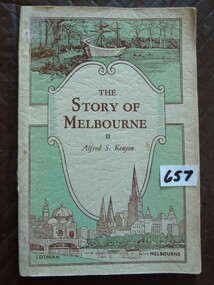 Stawell Historical Society Inc
Book, Alfred S Kenyon, The Story of Melbourne by Alfred S Kenyon, 1934
... . The Lower Panel is the largest contains a drawing of a river... is the largest contains a drawing of a river with a bridge crossing ...This Book is most interesting - Melbourne's Beginnings. The Inscription in front of this book M.G. Phillips (nee Taylor), taught school at Concongella during World War II.Soft Card cover of a green and cream colour Three Separate Panels on front cover. Top panel contains a drawing of a ship moored at shore with trees in background. Send Panel Is a Shield with curled side inside is The Title and Authors Name in Brown print. The Lower Panel is the largest contains a drawing of a river with a bridge crossing it, also a church and domed building with a clock tower in the distance. Back Cover contains a drawing of a series of books, in the shape of question mark with a Kookaburra sitting at the top.Inside front cover hand written M.G. Phillipsstawell education -
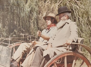 Wodonga & District Historical Society Inc
Album - Ringer's River by Des Martin - Plate 1 - Sean O'Day, Horse Breaker at "Gooloora" discusses his future
... while it was crossing the river during a flood, and has remained... it was crossing the river during a flood, and has remained at home ...On a summer's day in 1891 Sean O'Day, Horse Breaker on James MacLough's "Gooloora" Station, is driving the Scots pastoralist in to the railhead at Overton after his annual inspection of that property. Silent and mature for his age, Sean was born in a dray while it was crossing the river during a flood, and has remained at home in it. Because he is always moving by dawn he is known in the borderland as Daylight O'Day. When MacLough asks him what he will be doing on the morrow O'Day replies that he will be manager. Questioned, he suggests that MacLough realises the background to his joke in that the station hands will, that night, celebrate the passing of the Boss's inspection. As they will have hangovers tomorrow all the work will naturally fall to himself, a teetotaller. MacLough nods assent, but, instead of leaving on the train, books a room for the night and a livery gig for the morrow, and drives himself to Gooloora early next morning. D.J. Martin as O'Day, H.S. Diffey as MacLough.The album and images are significant because they document literature written by a prominent member of the Wodonga community. The presentation of this precis was supported by several significant district families and individuals.Ringer's River Album Coloured photo Plate 1des martin, many a mile, ringer's river, northeast victoria stories -
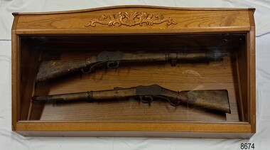 Flagstaff Hill Maritime Museum and Village
Weapon - Historic Rifles, Royal Small Arms Factory, 1877-1900
... history, and the river crossing provided travellers with access... grew around the crossing of the Merri River on the Melbourne... history, and the river crossing provided travellers with access ...Martini-Henry Artillery Carbin rifles were made by the Royal Small Arms Factory at Enfield, Britain, from 1877 until 1900. Many were distributed to the British Colonies, including this pair, which was allocated to the Woodford Police, Victoria Police District of Warrnambool, Southwest Victoria. The Carbine model rifles were shorter than the standard rifles and more suited to mounted police and troopers. It is likely that in the early 20th century, Victoria Police replaced the two carbines with more modern firearms, and the outdated guns were stored in the stables. The rifles were left there and likely forgotten about due to changes in police staff. In 1915, police authorities announced that they would be replacing patrol horses with bicycles and would also close some smaller police stations. This affected Woodford Police Station, which closed in 1917. The forgotten firearms remained in the stables and were noticed by schoolboy Robert Jellie in 1940 and seen again in 1946. In 1995, the property was sold by the Education Department to a private owner. The Woodford Community donated the pair of Martini-Henry Carbines to the Victoria Police Museum in the late 1990s for mounting and display, which was funded by the Victoria Police Historical Society Inc. The decorative wood and glass display case and frame were designed to preserve the significant history of the guns. On November 1st 1999, the display was presented to Warrnambool Police and the local community due to the historical significance of the Woodford Police Station. In 2025, these items were formally deaccessioned by the Victoria Police Museum, and ownership was transferred to the Warrnambool Police Station. On March 10th, 2025, the display was transferred to Flagstaff Hill Maritime Museum and Village, where the historical story of the Martini-Henry Carbines could continue to be preserved and accessed by local families, the community, visitors to the area, and online visitors. WOODFORD POLICE: - The small settlement at Woodford was established in the 1840s around the Merri River where there was a ford across the water and a bridge from 1848 to 1851. The area was settled very early in Victoria’s history, and the river crossing provided travellers with access to the early route between Port Fairy (named Belfast at that time), Warrnambool and Melbourne. Occasionally, a Warrnambool police trooper would ride through Woodford and the district. In December 1854, Woodford Police barracks and stables were built on the hill by the Merri River on Bridge Road east, where Jubilee Park now stands. A local mounted trooper kept law and order in the area. In 1856, a lock-up was installed, and the first Woodford Police Station was in action in 1857. By 1871, the police station had been moved from the hill to land across the Merri River bridge, on the southern side of Bridge Road west, near Mill Street. In 1890, the police residence there was replaced by a stone Edwardian-style building with the stables and lock-up behind it and the old police station at the rear. The police continued to have a presence in Woodford until it was closed by the Police Commissioner in July 1917 for economic reasons. The residence was used for government housing until 1923, when it was taken over by the Education Department for the school teacher’s home. In 1995, it became privately owned. THE MARTINI-HENRY ARTILLERY CARBINE: - The Martini-Henry rifles were made in Britain from 1871 at the Royal Small Arms factory at Enfield and were stamped with the symbol of the Royal Cipher (Crown over VR) over ENFIELD to identify their origin. They were named after two of several people who helped design this method: Swiss Friederich von Martini and Scotsman Alexander Henry. The design was breech-loaded, and the inner barrel was rifled. A thumb rest was incorporated into the top right of the bullet receiver’s chamber. The small teardrop lever on the right side of the rifle showed whether the rifle was ready to be shot. In 1877, the shorter, lighter-weight Carbine version of the firearm was produced for mounted troops and artillery. Its official name was “Carbine, B.L., Rifled, Martini-Henry.” The bullets were slightly lighter in weight than those used for the longer rifle. The sight position was adjusted for the shorter gun, and wings were added to the sight on the tip, making it easier to slide the rifle back into a saddle bag. Some of the later Carbines also had leather sight covers screwed to the stock to prevent them from catching on the saddle bags. The Carbines had accessories available, such as barrel extensions with bayonets and swivels for adding slings. The Martini-Henry Carbine designs were later modified to fire the British .303 ammunition. Eventually, by 1900, the Martini-Henry Carbines were replaced by the Lee Enfield gun design. The pair of Martini-Henry Carbine firearms represents policing in the early pre-1900 days of colonial settlement; Woodford was one of the first townships settled in Victoria, and it had a police presence from 1854 until 1917. The rifles and display provide a historic connection between the location of Woodford and relatives and associates. The carbine rifles show a stage in the evolution of weapon design, adapted to suit mounted troops, and adding features to streamline use and storage. The ammunition was also improved during this progression. The carbines are important for their connection to policing law and order in a remote area. They are significant for their association with the township of Woodford, which was important to travel in the southwest Victoria district, providing access across a river for a road between Port Fairy and Melbourne, and later Warrnambool, and supplying food, goods and accommodation for the travellers. A pair of mounted rifles is mounted behind glass in a timer case, accompanied by a framed display of two photographs and an account of the rifles’ history. The case and display each have a horizontal board with a gently curved edge and carved decorations added. The identical firearms are British-made Martini Henry Carbine breach-loaded rifled guns, supplied by Britain to its Colonial troops from around 1877. The rifles are lever-action, single-shot .500 calibre weapons. They have a teardrop lever on their right side. They were used by Victoria Police mounted troops at the Woodford Police Station, Victoria. The black and white photographs were taken in 1946. The left photograph has a circled area; the right photograph is an enlarged view of the circled area, showing the Woodford Police Station in detail. The printed text is on textured paper with the Victoria Police watermark. It gives a summary of the rifle’s history. There is an inscription on the left photograph. Left photograph, handwritten in white pen: “WOODFORD” Document’s print: “During the late 1840s the small town of Woodford grew around the crossing of the Merri River on the Melbourne/Port Fairy Rad. Woodford was proclaimed a township in 1854 and a police quarters was established there in 1857. The police station remained until 1917 when it was closed and police service from then on was provided from Warrnambool. The building was then used as a school residence and is now privately owned. In !940 Robert JELLIE, then a schoolboy, observed two rifles mounted on the wall of the disused stable at the rear of the old police building. Following the devastating flood of 1946 (see photograph above) the rifles were again seen in the room next to the stable but were not seen again until the building was sold by the Education Department many years later. It was a recognition of the historical value of the rifles which led to their donation to the Warrnambool Police Complex. The rifles have been authenticated by the Victoria Police Armoury as being Victoria Police issue some time before 1900. The rifles are an identical pair of the famous British-made Martini Henry, a .500 inch calibre military weapon widely used by British Colonial troops. Victoria Police and the wider community of Warrnambool are indebted to the members of the Woodford community for their fine gesture in donating the rifles for mounting so that their historical importance can be preserved and they can be displayed for generations to come. This display was funded by the Victoria Police Historical Society Incorporated, and presented on the first day of November, 1999.”flagstaff hill maritime museum and village, great ocean road, shipwreck coast, martini henry, victoria police, woodford police station, rifle, carbine, display case, british, martini henry carbine, breech-loaded, rifled, colonial, single-shot, .500 calibre, weapon, gun, 1877, troops, mounted troops, merri river, victoria police woodford, victoria police warrnambool, victoria police melbourne, police quarters, robert jellie, school residence, stable, 1946 flood, victoria police armoury, identical pair, british colonial troops, victoria police historical society incorporated, woodford, bicycles, found by a schoolboy, edwardian-style building, victoria police museum, warrnambool police station -
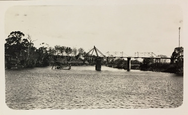 Kew Historical Society Inc
Photograph - Bridge over the Tambo River, 1926
... , crossing the river. Sections of the left hand pier and span can..., crossing the river. Sections of the left hand pier and span can ...Henry Beater Christian (1886-1962) , was a descendant of one of the earliest settler families in Kew. Employed at the Kew Asylum as a 'public servant', he was a skilled amateur photographer, photographing numerous scenes in Kew and on his travels around Victoria. The majority of his photographs date from 1916 to 1929. His finest photographs are housed in two photograph albums. Digital copy of a photograph from page 31 of the 47-page photograph album containing 261 gelatinous silver images, loaned by Diane Washfold with permission given to digitise and hold a copy in our collection. John Chapman has written in 'Bushwalking Clubs - A Brief History', about the establishment in Victoria of the first bushwalking club in 1888, and the popularisation of bushwalking during the interwar period. Henry Christian's 'walks' appear to have been undertaken solely or with a companion/s. This black and white photo is part of a group of six photos taken on an 18 kilometre walking trip between Bruthen and Swan Reach in East Gippsland in 1926. The route of the walk followed the Tambo River. The photographer has focussed the view on a ruined bridge, presumably caused by a flood, crossing the river. Sections of the left hand pier and span can be seen in the river."BRUTHEN TO SWAN REACH 1926"henry beater christian (1886-1962), landscape photography, christian-washfold collection, photograph albums, bushwalking, bruthen, swan reach, tambo river, east gippsland -
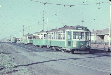 Melbourne Tram Museum
Slide - Set of 7, Keith Caldwell, 11/03/1962 12:00:00 AM
... location. .4 - X2 678 crossing Maribyrnong River Bridge - note... location. .4 - X2 678 crossing Maribyrnong River Bridge - note ...Set of 7 Agfa Colour slides, cardboard mounts, by Keith Caldwell dated 11.3.1962 of the transfer of cars from Footscray to the "Main System" the day after the system was closed. See Keith Kings history of Footscray notes. All trams running trolley wheels. .1 - Footscray depot cars X1 463, X2 678, X1 460 and X1 466 in Gordon St, about to turn into River Street. .2 - X2 678 turning from Nicholson St into Irving St. Footscray with the Rockmans Store in the background. This store was later demolished for the Ring Road. Also is J. Boltons Chemist shop advertising Kodak film and another shop advertising Darrell Lea Chocolates, Peters Icecream and ? Lopes fruit shop. .3 - X1 460 at same location. .4 - X2 678 crossing Maribyrnong River Bridge - note the person crouching down on the south side of the bridge behind the tram. .5 - X1 460 in Rosamond Road, just before the curve onto Williamson Rd. This site became the Bunnings site. The tram has a modified 21E truck. .6 - X2 468 as above with part of the curve in the view. Has an advertisement for Bon Stores of Hopkins St Footscray. .7 - X2 678 at ditto..1 - in ink - "Farewell Footscray" Sun 11.3.1962 - Footscray Depot cars departing areas en route to Main system." .2 - .7 all have "Footscray Sun 11.3.62"trams, tramways, footscray, closure, maribyrnong, gordon st, river st, irving st, maribyrnong river, bridges, x1 class, x2 class, rosamond rd, 21e trucks, tram 463, tram 678, tram 460, tram 466