Showing 3398 items matching "router"
-
 Melbourne Tram Museum
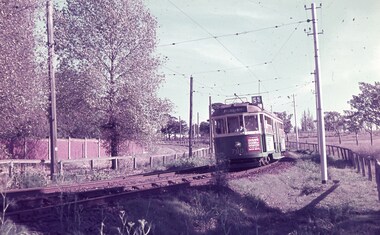
Slide - Set of 3, Keith Caldwell, 16/03/1962 12:00:00 AM
Set of four Agfa colour slide, cardboard mount, photo by Keith Caldwell 16/3/1962 of trams on the Royal Park - West Coburg line, route 55 or 56. .1 - W5 790, out bound running alongside the Zoo with a dry park in the background. Has an advertisement for Sharps doors of distinction. .2 - W2 346 photographed from an inbound tram, West Coburg, Route 55 .3 - W2 504 inbound, Domain Road, Route 56 with the Zoo walls and the Upfield rail line in the background. Tram has a Remy Martin Brandy advert.All have "16/3/1962" in blue ink and either "NR Royal Pk" or "W Coburg Route"trams, tramways, route 55, west coburg, the zoo, royal park, route 56, w2 class, tram 790, tram 346, tram 504 -
 Flagstaff Hill Maritime Museum and Village
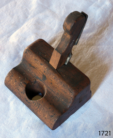
Tool - Router Plane, Late 19th to early 20th Century
Router planes are not the same as modern power routers. The simplest answer is that a router plane is a chisel held at adjustable vertical depths in a block of wood or metal. An antique-style router plane is mainly used for levelling out the bottoms of dado joints, mortises, and when installing hinges, inlays, and tenon cheeks, and similar other uses. There are three main categories or styles of router planes the earliest type of these is affectionately referred to as an "old woman's tooth", or "Grandma's Tooth". These planes can be as simple as a block of wood with the iron wedged in, and some have wedges with brass thumbscrews. Most of these router planes were shop-made tools their bottom flat so they can ride along the top of the wood, and the iron is adjusted to the desired depth by moving it up and down with your fingers.An interesting vintage joinery tool used before mechanical routers with early examples often sought after by collectors today. The subject item was probably made in a joinery workshop for a specific need in regards to producing a specific type of profile. As a result, even though the item appears to be quite old it has no makers mark, age and provenance are unknown.Router Plane Old Woman's Tooth pattern wooden stopper for holding the blade in place. Noneflagstaff hill, warrnambool, shipwrecked-coast, flagstaff-hill, flagstaff-hill-maritime-museum, maritime-museum, shipwreck-coast, flagstaff-hill-maritime-village -
 Melbourne Tram Museum
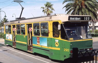
Slide, David Verrier, 5/02/2002 12:00:00 AM
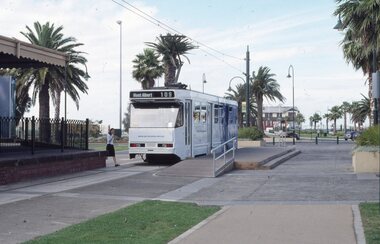
Agfa colour slide, white blue plastic mount. Photograph by David Verrier. Tram A 290 at the Port Melbourne terminus Route 109. Tram has the doors open showing the stop signs. Photos taken 5/2/2002.In ink: "Tues 5/4/02 290 Route 109 Port Melbourne"trams, tramways, port melbourne, a class, route 109, mont albert, tram 290 -
 Melbourne Tram Museum
Map, Ministry of Transport, Melbourne Public Transport Map - No. 9, 1979
Map No. 9 - Includes description of tram and bus routes, private bus routes. Has contact details for bookings and lost property etc and how to use the map. Yields information about Melbourne public transport services in 1979Fold out map (27 sections 9 across x 3 deep), "Public Transport Map", coloured of Melbourne's Tram and Bus routes, route numbers, rail lines, detailed for the central part of Melbourne and the outer Metropolitan services.tramways, melbourne, tram services, bus services, railways, travelcard, maps -
 Melbourne Tram Museum
Map, Ministry of Transport, Melbourne Public Transport Map - No. 11, 1980
Map No. 11 dated on rear as 1980 - Includes description of tram and bus routes, private bus routes. Has contact details for bookings and lost property etc and how to use the map. Yields information about Melbourne public transport services in 1980Fold out map (27 sections 9 across x 3 deep), "Public Transport Map", coloured of Melbourne's Tram and Bus routes, route numbers, rail lines, detailed for the central part of Melbourne and the outer Metropolitan services.tramways, melbourne, tram services, bus services, railways, maps -
 Melbourne Tram Museum
Slide, David Verrier, 5/02/2002 12:00:00 AM
Agfa colour slide, white blue plastic mount. Photograph by David Verrier. Tram A 294 at the Port Melbourne terminus Route 109. Has the Station Pier buildings in the background. Tram in Yarra Trams livery. Photos taken 5/2/2002.In ink: "Tues 5/4/02 294 Route 109 Port Melbourne"trams, tramways, port melbourne, a class, route 109, yarra trams, mont albert, tram 294 -
 Flagstaff Hill Maritime Museum and Village
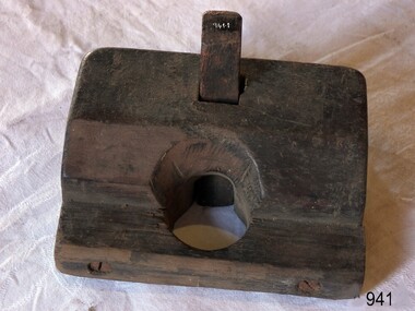
Tool - Router Plane, A Mathieson & Son, Mid 19th to early 20th centuries
... router ...The subject router is commonly referred to disparagingly as the ‘old woman’s tooth’ or ‘hag’s tooth.’ It is a router that houses a plough plane iron instead of a purpose made shoe-type cutting iron. They work fine but rarely give the type of clean surface required for veneer inlays. These types of tools are adjusted by the same hammer-tap tapping method used generally on wooden-bodied planes on the iron or plane body. These tools are effective and practical when used in general carpentry and joinery. Company History: The firm of Alexander Mathieson & Sons was one of the leading makers of hand tools in Scotland. Its success went hand in hand with the growth of the shipbuilding industries on the Firth of Clyde in the nineteenth century and the emergence of Glasgow regarded as the "second city of the Empire". It also reflected the firm's skill in responding to an unprecedented demand for quality tools by shipyards, cooperage's and other industries, both locally and far and wide. The year 1792 was deemed by the firm to be that of its foundation it was in all likelihood the year in which John Manners had set up his plane-making workshop on Saracen Lane off the Gallowgate in the heart of Glasgow, not far from the Saracen's Head Inn, where Dr Johnson and James Boswell had stayed on their tour of Scotland in 1773. Alexander Mathieson (1797–1851) is recorded in 1822 as a plane-maker at 25 Gallowgate, but in the following year at 14 Saracen's Lane, presumably having taken over the premises of John Manners. The 1841 national census described Alexander Mathieson as a master plane-maker at 38 Saracen Lane with his son Thomas Adam working as a journeyman plane-maker. In 1849 the firm of James & William Stewart at 65 Nicolson Street, Edinburgh was taken over and Thomas was put in charge of the business, trading under the name Thomas A. Mathieson & Co. as plane and edge-tool makers. Thomas's company acquired the Edinburgh edge-tool makers Charles & Hugh McPherson and took over their premises in Gilmore Street. The Edinburgh directory of 1856/7 the business is recorded as being Alexander Mathieson & Son, plane and edge-tool makers at 48 Nicolson Street and Paul's Work, Gilmore Street. The 1851 census records indicate that Alexander was working as a tool and plane-maker employing eight men. Later that year Alexander died and his son Thomas took over the business. Under the heading of an edge-tool maker in the 1852/3 (Post-Office Glasgow Annual Directory) the firm is now listed as Alexander Mathieson & Son. By the early 1850s, the business had moved to 24 Saracen Lane. The directory for 1857/8 records that the firm had moved again only a few years later to East Campbell Street, also off the Gallowgate, and that through further diversification was also manufacturing coopers' and tinmen's tools. The ten-yearly censuses log the firm's growth and in 1861 Thomas was a tool manufacturer employing 95 men and 30 boys; in 1871 he had 200 men working for him and in 1881 300 men. By 1899 the firm had been incorporated as Alexander Mathieson & Sons Ltd, even though only Alexander's son Thomas appears ever to have joined the firm. A vintage tool made by a well-known firm made for other firms and individuals that worked in wood. The tool was used for making timber veneers or smoothing a trench in a piece of timber that was then used in some form of cabinet manufacture or wood working enterprise. A significant item from the mid to late 19th century that today is sought after by collectors. It gives us a snapshot of how furniture was made predominately by hand and with tools that were themselves hand made and required considerable skill in their use. Old Woman's Tooth Router Mathieson. Single iron cut down from a larger plane iron. Has Marked A Mathieson & Son also stamped inscription on side G Hill. (owner)flagstaff hill, warrnambool, flagstaff hill maritime museum, maritime museum, shipwreck coast, flagstaff hill maritime village, great ocean road, plane, old woman's tooth, router, hag's tooth router, cabinet making, woodworking tools, a mathieson & sons, cabinet tool makers -
 Melbourne Tram Museum
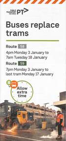
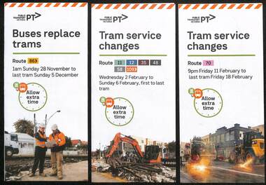
Pamphlet, Yarra Trams, Buses Replace Trams - Routes 58, 59, 86 and 96, 2022
.1 - pamphlet provided at tram stops giving details of the works and bus services for routes 58 and 59 .2 - Project document describing the work and dates - downloaded from the Yarra Trams website after buses were used to replace route 58 from the Royal Children's Hospital rather than from Royal Park Station as originally planned. .3 - as for .1 - for the upgrading of the Merri Creek Bridge - route 86 - see also Reg Item 6066 .4 - as for .1 - for the installation of superstops in Nicholson St between Elgin St and Holden St - route 96Shows the methods that Yarra Trams customers are advised of changes due to track replacement works..1 - Pamphlet - DL, four fold printed on off white paper titled - Buses Replace Trams - Route 58 and Route 59 - Jan 2022 .2 - Project sheet - 3 A4 sheets, titled "Renewal works: Essendon Depot and Mt Alexander Road - 3.1 to 18.1.2022. .3 - Pamphlet - DL 3 fold, Buses Replace Trams, route 86, November 2021 - Merrit Creek Bridge works .4 - Pamphlet - DL - 4 fold, Buses Replace Trams, route 96, January 2020 - Nicholson St works for tram super stops.mt alexander road, tram works, track work, route 58, route 59, yarra trams, ptv, essendon tram depot, route 86, route 96, nicholson st, merri creek, bridges, carlton, super stops, trams, tramways, northcote -
 Surrey Hills Historical Society Collection
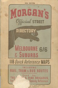
Book, Morgan's Official Street Directory, c1940s
incl.index. This Street Directory of Melbourne and suburbs, c1940s, includes a list of suburbs, their mileage from the city and how to reach them; an index to localities as well as the index to streets appearing on the maps. It also shows bus routes, railways and tramways routes on the maps.incl.index. This Street Directory of Melbourne and suburbs, c1940s, includes a list of suburbs, their mileage from the city and how to reach them; an index to localities as well as the index to streets appearing on the maps. It also shows bus routes, railways and tramways routes on the maps.melbourne metropolitian area, suburbs, cities and towns, maps -
 Melbourne Tram Museum
Ephemera - Map - Timetable, Melbourne & Metropolitan Tramways Board (MMTB), "Map and timetable of Melbourne Tram and Bus Services", March 1952
Map provided information about Melbourne's tramway network in 1952. At base of map - timetable of all night trams and bus services. On rear index to routes, 1st and last services, time of Sunday am services, Latrobe St. services and photo of Wattle Park. The conversion of Bourke St to electric trams marked up. Copy 1 - has been marked for hypothetical extensions in blue pencil mainly in the northern and western suburbs. In particular note the Ballarat Road and South Road markings. Copy 2 - has been marked up for newer route numbers, following the opening of the Bourke St services and additional route numbers on the Essendon Depot lines. Demonstrates the provision of information about Melbourne tram services.Fold out map (10 sections - 2 high x 5 wide), coloured of Melbourne's Tram and Bus routes, route numbers, rail lines, municipalities boundaries and location of major places of interest. melbourne, tram and bus services, mmtb, buses, trams, routes, timetables, all night services -
 Melbourne Tram Museum
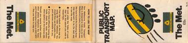
Map, The Met, "Public Transport Map - No. 13", 1984
Map No. 13 undated with the buzzing bee symbol on the front and throughout at the time of the introduction of the neighbourhoods. Includes description of tram and bus routes, private bus routes. Has contact details for bookings and lost property etc and how to use the map. Gives extensive details of the neighbourhood tickets and their used. C1984.Yields information about Melbourne public transport services in 1984.Fold out map (36 sections 9 across x 4 deep), "Public Transport Map", coloured of Melbourne's Tram and Bus routes, route numbers, rail lines, detailed for the central part of Melbourne and the outer Metropolitan services.tramways, melbourne, tram services, bus services, maps -
 Otway Districts Historical Society
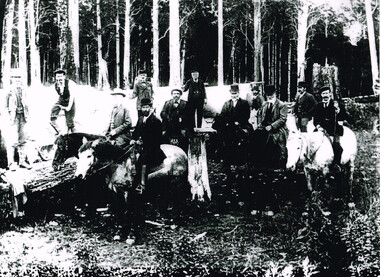
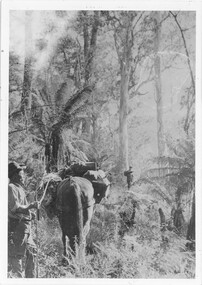
Photograph, Railway Survey Camp, Beech Forest, 4 Apr 1897, 4 April 1897
On the 18th August, 1896, the question of selecting localities for the permanent survey of a narrow-gauge line to Beech Forest from Colac was mooted. Two potential lines were examined. In a memorandum to the Minister for Railways, dated 23rd March, 1897, the Engineer-in-Chief recommended that the eastern and longer route via Lardner's Track be adopted. The second route, while identical from Colac to Gellibrand River, differed. By a more direct route the Beech Forest terminus is reached 5 miles sooner and cost approximately L24,500 less. The direct line would also serve a larger lot of settlers and would obtain a larger lot of traffic than the alternate proposal. The Parlimentary Standing Committee on Railways examined the proposal in situ and recommended that the direct route from Gellibrand to Beech Forest should be adopted and the Lardner's Track route should be abandoned at once.Photograph, Railway Survey Camp, 4 April 1897. Inspection of alternative routes by Parliamentary Committee on Railways.People named in the photograph.beech forest; railway; survey; victorian parliament; calcutt; fraser; e.h. cameron; d. mciville; a. harris; n. mcinnes; j.s. white; j. wood; t. baker; j. gardner; t.g. watson; standing committee; -
 Federation University Historical Collection
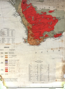
Map, Geological Map (Southern Western Australia), post 1880
Includes the routes of exploration, including E. Giles, A. W. Howitt, Burke & Wills, Hume & Hovell, Major Mitchell, A Forrest.A section of a map showing geology and routes of exploration. Southern Western Australia only geology, exploration, railways, electric telegraphs -
 Melbourne Tram Museum
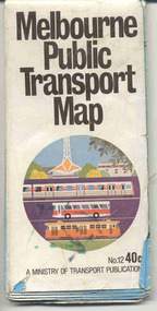
Document, Ministry of Transport, Melbourne Public Transport Map - No. 12, 1982
Map No. 12 - Includes description of tram and bus routes, private bus routes. On the front cover is composite image of Melbourne public transport vehicles. Has contact details for bookings and lost property etc and how to use the map. Priced at 40c, issue No. 12 of c1982. Has details of the then new Travelcard ticket system. Yields information about Melbourne public transport services in 1982.Fold out map (36 sections 9 across x 4 deep), "Public Transport Map", coloured of Melbourne's Tram and Bus routes, route numbers, rail lines, detailed for the central part of Melbourne and the outer Metropolitan services.tramways, melbourne, tram services, bus services, railways, travelcard -
 Melbourne Tram Museum
Map, Public Transport Corporation (PTC), "Public Transport Map of Melbourne", 5/1995
Map Includes description of tram and bus routes, private bus routes, and rail lines. Has contact details for bookings and lost property etc and how to use the map. Gives details of the ticketing system, along with photographs of the various modes. Dated May 1995 with a stylised image of some of Melbourne's landmarks on the cover. Published by the Public Transport Corporation.Yields information about Melbourne public transport services in 1995.Fold out map (36 sections 9 across x 4 deep), "Public Transport Map", coloured of Melbourne's Tram and Bus routes, route numbers, rail lines, detailed for the central part of Melbourne and the outer Metropolitan services.tramways, melbourne, tram services, bus services, maps, railways -
 Melbourne Tram Museum
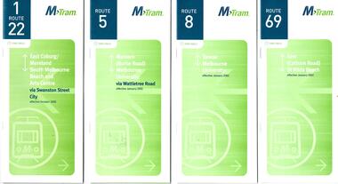
Ephemera - Timetable, M>Tram, Set of 8 M>Tram timetables, 2000 & 2002
Timetables for the following routes: 1 - Route 1/22 East Coburg - Moreland - South Melbourne Beach via Swanston St - Oct. 2000 2 - Route 5 - Malvern Burke Rd - Melbourne Uni - Jan 2002 3 - Route 8 - Toorak - Melbourne Uni Jan 2002 4 - Route 69 - Kew Cotham Road - St Kilda Beach - Jan 2002 5 - Route 82 - Moonee Ponds - Footscray - Oct. 2000 6 - Route 78/79 North Richmond - Prahran or St Kilda Beach - Jan 2002 7 - Route 59 - Airport West - City - Oct. 2000 8 - Route 57 - West Maribyrnong - via North Melbourne - Oct. 2000Details services operated by M>Tram c2002 and 2000Set of 8 M>Tram timetables, green cover with route number on cover, giving details of popular destination, checkpoints, use of Metcards and contact details, tram hire, frequency.trams, tramways, tram services, timetables, route 1, route 22, route 5, route 8, route 69, route 82, route 78, route 79, route 59, route 57 -
 Melbourne Tram Museum
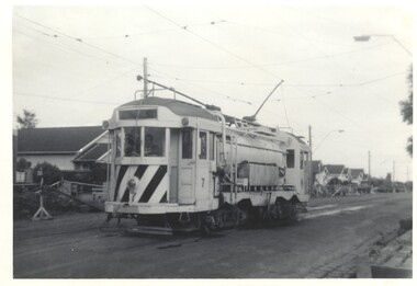
Photograph - Track cleaner 7 - East Coburg, Bob Lilburn, 24-4-1966
Photo shows MMTB Track cleaner No. 7 on the east Coburg Route in use during roadworks. The tram was fitted with cabins of W2 class trams when built. It is now at the TMSV Bylands site.Demonstrates the use of a track cleaner tram No. 7Photograph - Track cleaner 7 - East Coburgin ink on rear - MMTB - No. 7 - East Coburg Route 24-4-66 R Lilburn Photo.tramways, works trams, track cleaner, tram 7, east coburg -
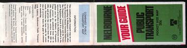
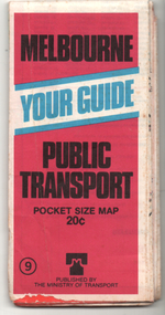 Melbourne Tram Museum
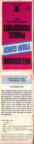
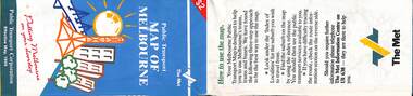
Ephemera - Map, Ministry of Transport, "Melbourne Your Guide PUblic Transport Pocket size map", 1979
Provided a detailed map of Melbourne's public transport, route number list and brief description. Has contact details for bookings and lost property etc. Priced 20c, published 1979 as map No. 9Demonstrates the methodology of providing map and transport information at the time.Fold out map (27 sections 9 across x 3 deep), coloured of Melbourne's Tram and Bus routes, route numbers, rail lines, detailed for the central part of Melbourne and insert section for Frankston. melbourne, map, tram and bus services, railways, mmtb, ministry of transport -
 Melbourne Tram Museum
Document, Melbourne & Metropolitan Tramways Board (MMTB), "MMTB Route Numbers - Bus Routes" 1961 & 1962
Provides a list of bus route numbers in 1961 and 1962. The 1962 sheet shows the additional routes following the take over of the bus routes in the Box Hill, Warrandyte and Ringwood areas.Yields information about bus route numbers.Set of two, Gestetner printed lists, foolscap sheets titled "MMTB Bus Routes Numbers". .1 - dated March 1961 - 1 sheet .2 - dated December 1962 - 2 sheetsItem 2 has "Obtained 2 May 1967" along top edge.tramways, trams, mmtb, route numbers, routes, buses -
 Halls Gap & Grampians Historical Society
Photograph - B/W, C 1890
The man with the horse is Charles D'Alton, his cousin Alfred is beckoning him to come on. Charles was ther son of William D'Alton if "Silver Springs" on Dairy Creek, and Fred (Alfred) was the son of John D'Alton, Stawell Borough engineer. Fred and Charles were responsible for finding many of today's walking track routes through the Wonderland Range and in the Mt. Rosea area. The second copy is a transparency (slide) , no. 182 in the slide box.Photo shows man, left side corner with pack horse andother man middle ground with arm raised"Charles D'Alton beckoning to his cousin Alfred to come on" finding the best routegilbert rogers, vehicle track, people, d'alton -
 Melbourne Tram Museum
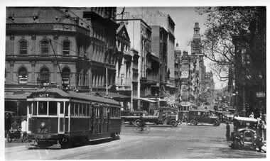
Photograph - Black and White - W Class Tram 272 in Collins St at Swanston St - no route number boxes, Circa 1930
Photograph of tram W 272 in Collins St looking west at Swanston Street. It is noted that it has no destination route boxes. Geoff Warburton notes say it received its route number box during May 1934 and it was sold in March 1980 to Seattle. USA. Not sure where it is now. Early photo of W tram without route number boxes.Black and white photograph slightly curled of W Class Tram 272 in Collins St at Swanston St . Note: No route number boxes.tramways, mmtb, traffic, trams, w class, tram 272, collins st. -
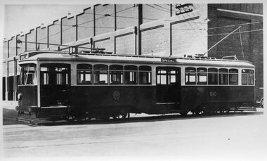 Melbourne Tram Museum
Photograph - Melbourne Y1 Class Tram 610 Photo, Melbourne & Metropolitan Tramways Board (MMTB), 1930
Photo shows the first build of the upgraded Y class design classified Y1 Class 610. Four of these Trams were built in the MMTB Preston Workshops in 1930, 610 to 613. There was one solitary Y Class tram 469. They were built with the intention of evaluating one-man operation. Due to their higher cost and Union resentment, the MMTB resorted to the proven W Class tram design. It is fitted with a route number box. The tram entered service 26/3/1930. It is now at Bendigo Tramways.Yields information about the first Y1 tram built by Preston WorkshopsPhotograph of Y1 610 at Preston WorkshopsThe inscription on the rear of 610 is " MMTB Y1-610 with Route No. Boxes. Preston Workshops.tramways, y1 class, tram 610, preston workshops, trams, mmtb -
 Melbourne Tram Museum
Pamphlet, Yarra Trams, Tram Service Changes, 2022
.1 - pamphlet provided at tram stops giving details of the works and bus services for 86 - Merri Creek Bridge works .2 - ditto - for provision of a super stop in William St at Collins St including replacement bus services on route 58 .3 - as for .1 - track reconstruction in Swan St between Stanley St and Stawell St Richmond or BurnleyShows the methods that Yarra Trams customers are advised of changes due to track replacement works..1 - Pamphlet - DL, three fold DL - Buses replace trams - route 86 - 28/11/2021 to 5 December 2021 - Route 86 .2 - Pamphlet - DL, four fold DL - Tram Service changes 2/2/2022 to 6/2/2022 - Routes 11, 12, 35, 48, 58 and 109 .3 - Pamphlet - DL, four fold DL - Tram Service changes - 11/2022 to 18/2/2022 - Route 70tram works, track work, route 58, yarra trams, ptv, route 86, merri creek, bridges, super stops, trams, tramways, richmond, burnley, route 70, collins st, william st -
 Ballarat Tramway Museum
Map, Ministry of Transport, "Melbourne Public Transport Map" - "No. 12", 1982
Pocket size - folded - public transport map of Melbourne, printed in colour on paper, showing public transport services in greater Melbourne, including ticketing information, travelcards and an index of localities. The Central zone area shown in detail. On the rear, route numbers and line maps of tram routes and train lines or services and fare zones. The first map with the new three zone system of fares. Includes private bus routes. Printed 1982 by Government Printer. Issue No. 12.On inside, a circle route around Flinders, Queen, Little Collins and Swanston St in blue felt pen and arrow in blue ink. On the rear, a sketch map showing the location Charles St, Mantell St and William Road, and a circle around Upfield station.trams, tramways, melbourne, map, routes -
 Melbourne Tram Museum
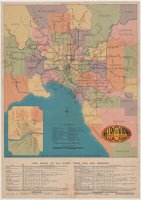
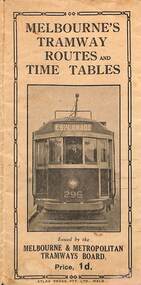
Map, Melbourne & Metropolitan Tramways Board (MMTB), Melbourne's tramway routes and timetables - MMTB, 1925
Map of the MMTB Tramway routes 1925 with a list of first and last cars, along with photographs of Wattle Park, Luna Park, and Studley Park. Provides information for the Prahran and Malvern lines, Hawthorn, Footscray, Essendon, Coburg, Kew, St Kilda, cable tram routes, and buses. Also provides information for passengers. The cover photo is of the front of W 296, with the destination of Esplanade. The map is dated by the opening of the line to West Brunswick as far as Albion St, the City Road to St Kilda line via Sturt St lines, and the electric line in Flemington Road which were all opened during mid to late 1925. See Reference. Shows a number of buildings and locations by a numbered reference list, including the Federal Parliament house. The map has advertisements around the outside of the map for Kiwi Shoe or boot polish.Yields information about the Melbourne tramway system in 1925 and demonstrates the methodology the MMTB used to provide information to travellers. Shows both cable and electric tram lines and the development of the Melbourne system.Map book - 15 fold paper titled "Melbourne's tramway routes and timetables"trams, tramways, mmtb, tramway maps, wattle park, studley park, timetables, cable trams, w class tram, tram 296, kiwi shoe polish -
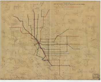 Melbourne Tram Museum
Drawing, Melbourne & Metropolitan Tramways Board (MMTB), "Route Map showing location of special work and pole numbers" "All night tram routes in colours", late 1941
Map of the system shown at two inches = 1 mile. Drawing No. P5799. Shows crossovers, track layouts at junctions, signal cabins roads, railways, and stations. Originally signed by Perway Engineer - 20/12/1940, though originally drawn in 1922. Has been marked up in colour pencil to show the all-night routes and the individual services. The plan shows the lines to Maribyrnong Munitions works along Cordite Ave and Wests Road and the track from Moonee Ponds to Union Road, opened in July 1941, but not the extension to Essendon Airport built in 1942.Demonstrates a detail drawing of Melbourne tramways, junctions and pole numbers.Drawings - dyeline cloth-backed print - titled - "Route Map showing the location of special work and pole numbers" and subtitled - "All night tram routes in colours". trams, tramways, mmtb, trackwork, tramways, junction, map, world war 2, night trams -
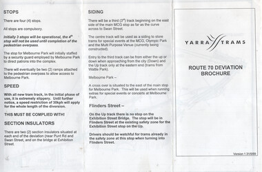 Melbourne Tram Museum
Document, Yarra Trams, "Route 70 Deviation Brochure", 5/1999
Document issued to crews at the time of the opening of the Batman Ave Deviation in June 1999. Pamphlet dated 31/5/1999. Wikipedia Reference for the route dates the use from 6/6/1999. Has a map, notes on the tram stop, speed, section insulators and the siding. Published by Yarra Trams.Demonstrates a Yarra Trams pamphlet at the time of the relocation of route 70 from the Batman Ave terminus to its operation via Flinders St and the Exhibition St bridge.Document - or pamphlet - titled "Route 70 Deviation Brochure" - A4 sheet, 3 fold DL.tramways, route 70, yarra trams, new tramways, batman ave, new track -
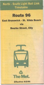 Melbourne Tram Museum
Document - Timetable - Route 96 - East Brunswick - St Kilda Beach, The Met, 2/1991
Timetable dated 6-2-1991 provides information on the East Brunswick to St Kilda Beach via Bourke Street services, including a map, route description, time points, fare secrtions and contact details. Published by The Met. Has the words "North-South Light Rail Link" on the top of the document. Yields information about Route 96 tram services on the St Kilda light rail line.Document - 10 fold sheet - Timetable - Route 96 - East Brunswick - St Kilda Beachtramways, timetable, route 96, east brunswick, st kilda beach, light rail, the met -
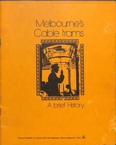 Melbourne Tram Museum
Book, Science Museum, "Melbourne's Cable Trams - A brief history", 1975
Book produced by the Science Museum provides a brief history of the cable tram system, with photos. Includes details of the engine houses, the cable, the grip mechanism, the ticket bell punch, and why "Mind the Curve". Has a list of acknowledgments. Published shortly after or at the time of the launch of the tram in the enclosure in Russell St. The additional sheet with the book provides details for each route of route, the location of the city terminus, suburban terminus, running time, night light, route length, first and last car for each day of the week. Not known who compiled the sheet.Demonstrates the work of the Science Museum - now Scienceworks.Book - 16 pages + card cover +postcard of cable tram set No. 1 at the Science Museum 1975. Inside the book is a ruled sheet of paper with details of the cable tram routes, handmade with ink.tramways, cable trams, science museum, melbourne -
 Whitehorse Historical Society Inc.
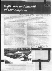
Article - Manningham Matters, Dr Richard Lay, Highways and Byways of Manningham, June 2021
August Schwerkolt walked between his properties at Northcote and Mitcham and probably crossed the Yarra River at the Banksia St bridge and took the ridge route which is now the Manningham, Doncaster and Mitcham Roads.August Schwerkolt walked between his properties at Northcote and Mitcham and probably crossed the Yarra River at the Banksia St bridge and took the ridge route which is now the Manningham, Doncaster and Mitcham Roads.non-fictionAugust Schwerkolt walked between his properties at Northcote and Mitcham and probably crossed the Yarra River at the Banksia St bridge and took the ridge route which is now the Manningham, Doncaster and Mitcham Roads.schwerkolt august, mitcham, doncaster road, mitcham road