Showing 793 items matching "rural road"
-
 Glen Eira Historical Society
Caulfield Properties
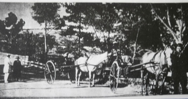
... Newspaper photograph of horse drawn buggies in Orrong Road... VIC 3162 melbourne Caulfield Orrong Road Buggies Horses ...Newspaper photograph of horse drawn buggies in Orrong Road showing rural Caulfield, circa 1857caulfield, orrong road, buggies, horses -
 Eltham District Historical Society Inc
Journal - Newsletter, Nillumbik Shire Council, Nillumbik News, October 2000
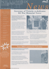
... Eltham Festival Album Rural connector roads strategy Rural... Eltham Festival Album Rural connector roads strategy Rural ...Christmas 2001 articles include: Governor of Victoria re-dedicates KG War Memorial Tower Election details (2002) Summer at the Diamond Creek Pool Community Safety Expo Nillumbik Festival of the Arts: ‘art, caught in the act’ 22 Feb to 3 Mar 2002 Neighbourhood Character Study out for comment Plans to revive St Andrews Market site Integrated Transport Strategy seeks less car usage Eltham Festival Album Rural connector roads strategy Rural Collector Roads to be Sealed Roundabout funding for Diamond Creek Community Fireguard helps prepare for fire Planning for bush fire this summer Capital Works projects on track for 2001-2002 Eltham Town Square opens council newsletters, nillumbik news, nillumbik shire council -
 Linton and District Historical Society Inc
Photograph, Postcard : group of people on bushland outing, c.1911
... in rural setting (possibly Mortchup Road reservoir).... to be a Linton State School group, on an outing in rural setting ...Postcard given to Stella Todd by Linton State School head teacher Mr H. B. Williamson, wishing her a happy year in 1912.Black and white postcard photograph of men, women and children, thought to be a Linton State School group, on an outing in rural setting (possibly Mortchup Road reservoir)."To Stella Todd with best wishes for the new year 1912 from her teacher H B Williamson".stella todd, stella surman, linton state school no. 880, h. b. williamson [head teacher], picnics -
 Greensborough Historical Society
Slide - Photograph, John Ramsdale, Whittlesea to Wallan Road: Slide 89, 1990s
... Photograph shows road and rural scene... Plenty Lower Plenty melbourne Photograph shows road and rural ...Photograph shows road and rural scene. this is the Whittlesea to Wallan Road north of Whittlesea.Part of the John Ramsdale collection of slides and audio visual material.Colour photograph scanned from slide.No maker's marks. No caption on slide.whittlesea, wallan, whittlesea to wallan road -
 Eltham District Historical Society Inc
Journal - Newsletter, Nillumbik Shire Council, Nillumbik News, October 2000
... maintenance Regional Road upgrades Rural roads grading program... maintenance Regional Road upgrades Rural roads grading program ...October 2000 articles include: Safer roads for the Shire Eltham Festival program announced Commercial Place design released 2000-2003 Council Plan Released National Reconciliation Framework Living and Learning Centres More Playgrounds Susan St Pavilion completed Study to plan for BMX/skate track Wattle Glen Township Strategy Community Weed Control Program Count Koala Day Environment Centre proposed for Edendale Farm Open Space Strategy findings Neighbourhood Character Study and Residential Design Guidelines Friends groups Clean Drains – Living Creeks, National Water Week Nillumbik Shire Council Cultural Plan 2000-2005 adopted 2001 Alan Marshall Short Story Award Artists’ Open Studios program Kangaroo Ground Tower Advisory Committee Environment leaders at Eltham North primary Dollars saved by regular road maintenance Regional Road upgrades Rural roads grading program Stormwater Management Plan Locality boundary update council newsletters, nillumbik news, nillumbik shire council -
 Ballarat Tramway Museum
Slide - 35mm slide/s - set of 2, Eldon Hogan?, late 1950's
... Eaglehawk in a very rural situation, unsealed road sides... Eaglehawk in a very rural situation, unsealed road sides ...Set of two Agfacolor cardboard mounted slides - have handwritten captions and two numbers - no date, pre dash canopy stripes and additional lights, late 1950's? Scanned on the Canon scanner at the depot 15/12/1971 at the time of the installation of the scanner. .1 - Bendigo 13, outbound in Pall Mall with the Shamrock Hotel in the background. .2 - Bendigo 2, in bound from Eaglehawk in a very rural situation, unsealed road sides, with the Destination of Quarry Hill..1 - "Tram No. 13 in Pall Mall Bendigo / 24)" in red ink. .2 - "Tram No. 2 approaching Bendigo / 25)" in red ink.tramways, trams, bendigo, eaglehawk, pall mall, tram 13, tram 2 -
 Kiewa Valley Historical Society
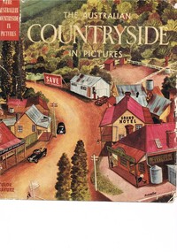
Book - Reference Countryside, The Australian Countryside in Pictures, circa 1950s
... leaf is a colour photograph of a rural scene with dirt road... of a rural scene with dirt road running in the centre and to the left ...This book is a "snapshot" in time (1950s) detailing life in Australia covering a time when a "man's word and handshake" were his moral and quasi legal bond, and the now relative defunct saying "smoko" (having a "time out" from work for a cigarette and tea or coffee). The book spans an era where the male was still the "head" of the family even though for a majority of families the women took on the many "male only" roles during the World War II period. This shift in the leadership of the family hierarchy is mentioned, so ever slightly, (not to offend the still predominant macho male image) in both rural and city environments. The effects of the war, and later the push for women's emancipation and equality in both family, social, workplace and political areas of life, since this book was published, is now finally resolved. However there are still some sections of the recent migrate population where this male dominance is causing a few problems.The significance of this book is not only because it was donated by Mrs C. Roper ( from the Roper Family, a pioneer Kiewa Valley and surrounding Region family - originally beef cattle graziers) but also a Kiewa Valley resident and family, experiencing the shift in the social and economical life of post World War II rural Australia. The strong heritage link to this region of many families still residing within its boundaries, is a clear affirmation of the bond that the Kiewa Valley and its Regions have upon family unity. This unity within the rural environment is something that is attracting more and more families from sometimes alienating city life.This printed coloured sketched, or painted paper sleeve of the book is freely wrapped over a dark red hard cover. Into the front of the cover is pressed a standing pose of a farmer with long sleeves rolled up over his elbows. Behind him and to the right are what appears to be three sacks of wheat and next to him is a merino sheep. To the left and down are two dogs one with a fox in its jaws. The book contains 240 pages, 300 illustrations in gravure and 25 pictures in full colour. The inside fly leaf is a colour photograph of a rural scene with dirt road running in the centre and to the left a farm house and a five bay open storage barnOn the tittle page is a signature "C Roper"country life, australian "outback", rural industries, life on the land, swag-man of the bush -
 The Beechworth Burke Museum
Audio - Oral History, Jennifer Williams, Mr Alfred Spencer, 17th February 2000
Alfred 'Alf' Spencer grew up on a dairy farm run by his mother, west south west of Beechworth 'down Robertson Road', and was very well connected to the wider Beechworth area. In this oral history, he recalls his time driving the milk cart around Beechworth as well as the time he spent buying lollies and seeing the pictures. He talks extensively about working as a butcher at his brother's store, including how the butchers interacted with the rest of the town and the staff, as well as his time constructing roads and the pipe network of Beechworth. He discusses the dynamics of other workplaces around Beechworth, describing issues with how the local tannery treated its workers as well as how post-war migrants integrated across the town. He briefly discusses racial tensions between Chinese migrants and other miners on the goldfields. He also discusses the experience of health care in a rural area during his childhood. This oral history recording was part of a project conducted by Jennifer Williams in the year 2000 to capture the everyday life and struggles in Beechworth during the twentieth century. This project involved recording seventy oral histories on cassette tapes of local Beechworth residents which were then published in a book titled: Listen to what they say: voices of twentieth century Beechworth. These cassette tapes were digitised in July 2021 with funds made available by the Friends of the Burke.Alfred Spencer's oral history of his life around Beechworth during the 20th century is historically and socially significant to the cultural history of the region and Victoria. There is a lot of detail about workplaces, their staff, and how the resources of the town interacted. He explores themes that are important to Victorian history, such as migration. This oral history account is socially and historically significant as it is a part of a broader collection of interviews conducted by Jennifer Williams which were published in the book 'Listen to what they say: voices of twentieth-century Beechworth.' While the township of Beechworth is known for its history as a gold rush town, these accounts provide a unique insight into the day-to-day life of the town's residents during the 20th century, many of which will have now been lost if they had not been preserved.This is a digital copy of a recording that was originally captured on a cassette tape. The cassette tape is black with a horizontal white strip and is currently stored in a clear flat plastic rectangular container. It holds up to 40 minutes of recordings on each side.Mr Alfred Spencer /listen to what they say, beechworth, oral history, burke museum, spencer, alfred spencer, migration, post-war migration, goldfields, health care, farm, farming, dairy farm, black springs, butchers, meat processing, butcher, road, road network, labour relations -
 The Beechworth Burke Museum
Audio - Oral History, Jennifer Williams, Mrs Val Mason, 5 January 2001
Mrs. Valerie (Val) Mason (1927-2019) was a local sheep farmer, business-woman, Beechworth shire councillor, and mother to five children. With her husband, Charles, Mrs. Mason developed and managed the Big Valley farm estate, at Everton, which is now part of a vineyard and farm stay. Mrs. Mason was instrumental in introducing a 'paddock to plate' philosophy and business model, opening a butcher shop on the farm in 1973. Concerned with improving infrastructure and developing economic opportunities in the region, Mrs. Mason successfully stood as a local council representative for South Riding in the United Shire of Beechworth, and later become the first woman Shire President in 1979. Mrs Mason was a member of the local Business and Professional Women's Club for 37 years. This oral history recording was part of a project conducted by Jennifer Williams in the year 2000 to capture the everyday life and struggles in Beechworth during the twentieth century. This project involved recording seventy oral histories on cassette tapes of local Beechworth residents which were then published in a book titled: 'Listen to what they say: voices of twentieth century Beechworth. These cassette tapes were digitised in July 2021 with funds made available by the Friends of the Burke.Mrs. Mason's story is historically significant for understanding economic and social changes in the Beechworth region during the latter half of the twentieth century. As a council representative, issues such as road and infrastructure modernisation and the transition from traditional government employment sectors, like Beechworth's care institutions, were challenges for local government. As a farmer and local employer, Mrs. Mason's story is testimony to the region's economic diversification as businesses like Big Valley farm shop helped shape the region's contemporary character. Mrs. Mason was among the first women to broach the traditionally all-male Beechworth Council Chambers and her story is socially significant for understanding the changing role of women in rural and regional Australia. This oral history recording offers interpretive capacity for social history themes and may be compared with other oral histories in the Burke Museum's collection. This oral history account is socially and historically significant as it is a part of a broader collection of interviews conducted by Jennifer Williams which were published in the book 'Listen to what they say: voices of twentieth-century Beechworth.' While the township of Beechworth is known for its history as a gold rush town, these accounts provide a unique insight into the day-to-day life of the town's residents during the 20th century, many of which will have now been lost if they had not been preserved.This is a digital copy of a recording that was originally captured on a cassette tape. The cassette tape is black with a horizontal white strip and is currently stored in a clear flat plastic rectangular container. It holds up 40 minutes of recordings on each side.Mrs Val Mason /listen to what they say, beechworth, oral history, burke museum, working women, trail blazers, farm to plate, farm shop, paddock to plate, woman farmer, united shire of beechworth, rural and regional women, beechworth's first woman shire president, women in leadership positions, women leaders, australian settlement history, settler societies, victorian gold rush, heritage tourism, culinary tourism, regional land use, indigo winery, farm stay, social history -
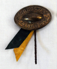 Orbost & District Historical Society
badge
This badge was found underneath a house in Marlo Road. The Orbost football club players were known as the Busters and wore green and gold guernseys. An Orbost football team has participated in the East Gippsland League since the early 20th century. In 2003 in response to a dwindling population, the Snowy Rovers and Orbost Football Clubs were driven to merge into the Orbost Snowy Rovers. Football Club through its many changes has always been an important social fabric of the Orbost community. Sport is often regarded as an important part of life in rural Australia, contributing to community identity, sense of place, social interaction and good healthAn oval shaped metal badge / pin with celluloid ribbons of green and yellow. There is a raised football in the centre.Orbost F.C. Patron 1950 -
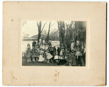 Orbost & District Historical Society
black and white photograph, 1920s
The bridge shown in the background was built in the 1920s as a road and rail bridge, and was partly washed away by flood waters in 1934. There is no known history of this item.This photograph is a contemporary record of rural life in Orbost in the early 20th century.A black / white photograph of a group of young girls dressed up and posing on the banks of a river. On the left hand side of the photograph is an older man and on the right is an older lady. In the background is a bridge - the first Snowy River bridge. The photograph is on a cream coloured buff card. orbost snowy-river -
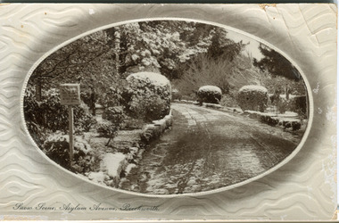 The Beechworth Burke Museum
Postcard, R & B Hall, c.1930
This postcard was published by R. & B. Hall in Beechworth and printed in Saxony, circa 1930. Saxony is a landlocked state of Germany which borders the states of Brandenburg, Saxony-Anhalt, Thuringia, Bavaria and the countries of Poland and the Czech Republic. This particular postcard is embossed with a pattern which surrounds the middle image in the center of the card. This image depicts Asylum Avenue which leads to the Mayday Hills Asylum in Beechworth, Victoria. What makes this scene particularly interesting is the appearance of snow which is rare in Beechworth. The road depicted on the postcard has track marks made by a car with thin wheels. Beechworth's Mayday Hills was chosen as the site of Victoria's newest asylum, at the time, due to the landscape and altitude. The hilltop atmosphere and the native fauna, it was argued, would assist in the cure of the patients kept at the hospital (Wood 1985, 122). The positioning of the hospital had a beneficial effect on the rural town. A pamphlet published by James Ingram and Son (1849) reveal that famous landmarks in Beechworth which included the Post Office, Gaol, Courthouse and Asylum "demonstrate the appreciation of Beechworth by the Government not only as as important district center, but also as a site unrivaled as a sanitarium". There were other locations in contention at the time, but ultimately Beechworth was chosen (Craig 2000, 33). Prior to the creation of the Asylum in Beechworth, those charged with having mental illnesses or, as it was termed, "insanity" were unable to be properly cared for in the Gaol (which is where they were often sent). John Buckley Castieau wrote, in 1861 for the Ovens and Murray Advertiser, that the Gaol was unable to properly care for those classified then as "insane" but that they would endeavor to treat them above the other inmates (which he notes is not always the case in other establishments). Castieau wrote this in favour of supporting the building of the Mayday Hills Hospital in Beechworth. It was stated that at the time the Mayday Hills Hospital was built, there were 83 prisoners kept in the Gaol who were to be rehoused to the Hospital on the grounds of "insanity". The classification as someone as "insane", in this period of time is a reflection on the inability to cure and understand illnesses of the mind during the mid to late 1800s. Beechworth's Mayday Hills was chosen as the site of Victoria's newest asylum, at the time, due to the landscape and altitude. Opening on the 24th of October 1867, the Mayday Hills Hospital was originally named the "Ovens Lunatic Asylum", a title which is very much a product of its time. Whilst controversial, changes to the name is part of the history of the Hospital and can provide much insight into the understanding of mental illness throughout history and the use/disuse of this term provides information into the reception/changing opinions of mental illness in society. The Hospital would later become known as the "Mayday Hills Asylum" and/or "Mayday Hills Hospital" with the latter being the most commonly used title. An article in the Ovens and Murray Advertiser notes that on the 7th of March 1865, the foundation stone of the Hospital was laid (it would officially open in 1867) and that it was such a moment of accomplishment and joy for Beechworth that a letter to the editor even suggested that there should be a holiday dedicated to the day the foundation stone as laid. This reveals an extent to which the townspeople of early Beechworth valued the construction of the Hospital in their town. It provided the town with a sense of prestige and honour.At first glance, the remains of the Mayday Hills Hospital in Beechworth, Victoria, inspire tragedy, trauma and beauty. The buildings themselves, with their Italianate style Renaissance architecture designed by J.J. Clark (Craig 2000, 49 & Smith 2016, 203) reflect a bygone period of European and Australian history. The gardens provide a sense of tranquility and beauty. The experience of those within these walls remains a valuable area of study to provide a more complete understanding. This particular hospital is considered the fourth of its like and one of three identified as the largest of their kind. The Mayday Hills Hospital is a sister to the Kew and Ararat Asylums in Melbourne which are both located in relative proximity. Understanding the role of the Mayday Hills Hospital in Beechworth history is integral to understanding the development of the goldfields town, but also for providing important information as to the history of caring for, and the reception of, mental illnesses in Australian and wider European history. Mayday Hills provides a case study which can be researched through oral history, an analysis of the grounds/buildings and through images like this postcard which portray the structure in a highly deliberate manner. Images like this depict the strong façade of the Hospital and provide a glimpse into the tranquility of the gardens. This has been done deliberately to provide a sense of comfort and healing about the building to those looking from the outside. Further research into the importance of the Hospital in Beechworth and it's connection to the town will be supported through images like these kept in the Mayday Hills photo album in the collection of the Burke Museum.Pale coloured rectangular postcard printed on matte embossed card.Obverse: Snow Scene; Asylum Avenue, Beechworth. / Reverse: POST CARD / ADDRESS ONLY / Published by R. & B. Hall, Beechworth. / Printed in Saxony. / 3447 [crossed out] / 1997.2492 / AFFIX STAMP /asylum, asylum avenue, beechworth, snow north-east vic, victoria, snow scene, mayday hills, mayday hills hospital, mental hospital, colonial attitudes, mental health, history, town development, postcard -
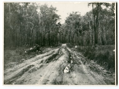 Orbost & District Historical Society
black and white photograph, 1924
This photograph shows the main road near Bellbird, East Gippsland, in 1924. This road would have been the Princes Highway, a main thoroughfare through to New South Wales. Bellbird Creek is a small rural location between Orbost and Cann River. There was no township at Cabbage Tree at this time. The Cabbage Tree Creek township was established to support the booming timber industry of the mid 20th century. Five timber mills worked full time supporting the families that were drawn to the area's wealth of natural resources. Nestled on the banks of the Cabbage Tree Creek, the township was built by those mills to house their workers. Today although the timber mills have disappeared, some of the buildings still remain. Little now remains to remind of the saw-milling history apart from photographs and some relics - a boiler and a brick furnace. There was also a thriving agricultural community farming dairy, beef, seed beans and fresh peas and beans that were sent to the Victoria Market in Melbourne. Dairy farming still plays an essential role in the township. this is a pictorial record of the Princes Highway, the main road from East Gippsland to the New South Wales border.A large black / white photograph of a very wet and boggy bush road.on front - "Main Rd near Bellbird 1924"road princes-highway bellbird-creek-1924 -
 Ringwood and District Historical Society
Pamphlet, Southwood Primary School (Ringwood) advertising flyer
Light green coloured, folded A4 paper pamphlet titled "A School of Pride and Quality" advertising Southwood Primary School enrolements. Address - Maidstone St, Ringwood, 3134, PH: 9870 4106 List details of facilities, curriculum, and parental involvement. Advertises after school care. Some B&W photos of students. Descibes Southwood as a School of the Future, striving to 'preserve a rural school ethos' -
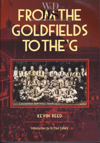 Warrnambool and District Historical Society Inc.
Book, Kevin Reed, From the Goldfields to the G, 2014
An account of the development of Australian Rules football in both rural and suburban Victoria.This is a paper back book with a red and gold cover with a photograph of Costerfield Football Team, 1919 on the cover (335 pages) The book is signed inside by Kevin Reed non-fictionAn account of the development of Australian Rules football in both rural and suburban Victoria.warrnambool, kevin reed, dr john douglas, warrnambool cricket 1980's, warrnambool football 1970's 1980's -
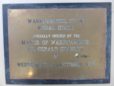 Warrnambool and District Historical Society Inc.
Plaque, Warrnambool Co-op Rural Store, 1997
The Warrnambool Co-operative had its beginnings as the Allansford Artificial Breeders Co-operative in the 1960's. In the 1970s they opened a retail store in Timor Street which had a strong rural and farming base which gradually expanded to become the largest trading department store in the district. By the late 1990's they had 8000 members and employed 84 full time and 120 casual staff. It met a sorry end in the 2000's.This plaque commemorates the opening of the Rural store which consolidated the large rural aspect of the business. It opened up the site from Merri Street at the back of the Timor Street building trading in all agricultural products, , chemicals and fuels.A link to one of Warrnambool's largest stores of the latter part of the 20th century and as such it has historical and social significance. Rectangular brass plaque with stamped black text with eight screws around the edge attaching it to a piece of heavy particle board , painted black.Warrnambool Co-Op rural Store officially opened by the Mayor of Warrnambool Cr. Gerald Shanley on Wednesday, 8th October 1997.warrnambool co-operative society limited, warrnambool co-operative rural store, warrnambool -
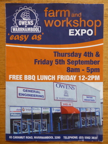 Warrnambool and District Historical Society Inc.
Pamphlet, Owens of Warrnambool
This is a brochure produced for the Owens of Warrnambool Farm and Workshop Expo. The story of Owens of Warrnambool began in the 1880s when Flett and Hopkins began a plumbing and blacksmith business in Lava Street. In the early 1900s the business was taken over by Bruce and McClure who added a foundry and produced and serviced farm equipment. In 1945 the business was purchased by four Owen brothers. In 1953 the business became known as Owens of Warrnambool. In 1987 the business was purchased by Alan Lane and following his death in 1995 the business became part of the Alan Lane Foundation. In 2000 the business was transferred to Caramut Road. This brochure is of some interest as it contains information on Owens of Warrnambool, a prominent business in Warrnambool today and one with a significant history in the city. This is an Owens of Warrnambool A4- size fold-out brochure of three pages, printed back to back. There is information on the history of Owens of Warrnambool, Owens Water Industries, Owens Rural and Industrial Supplies and associated firms with their logos. There are black and white and colour photographs and the front page features the Owens logo and a photograph of the shop front in Caramut Road, Warrnamboolowens of warrnambool, warrnambool -
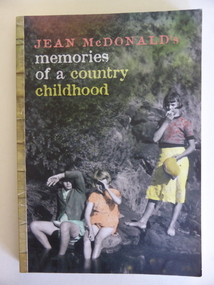 Warrnambool and District Historical Society Inc.
Book, Memories of a Country Childhood, 2008
This is a book by Jean McDonald (nee Henderson) telling of her childhood experiences. Born in 1924 Jean McDonald was one of seven children who grew up at Rivery Park, a dairy farm in Grassmere in the 1930s and 40s. She went to school in Cooramook and Warrnambool. This book is of interest as it describes the life of Jean McDonald in Grassmere. It is an important social history of the life and times of a local woman. This is a soft cover book of 189 pages. The front cover has a coloured photograph of three children near a stream and the back cover has an extract from the book and some comments on it. The book contains ten chapters and many black and white photographs. ‘M. Jansen’ jean mcdonald, grassmere, cooramook, rural life in the western district -
 Warrnambool and District Historical Society Inc.
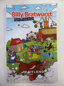
Book, Billy Bratwurst, 2013
This is a fictional story about a small boy growing up in rural Australia. The author, Jo Hyland, lives in Woolsthorpe. The story, written in a light-hearted way, is suitable for adults and older children. This book is of minor interest as it was written by a resident of Woolsthorpe, a small town in the Warrnambool district. This is a soft cover book of 134 pages. The cover is multi-coloured with many comic images centred around the activities of a small boy. The book contains 22 chapters. jo hyland, history of warrnambool -
 Kiewa Valley Historical Society
Photographs – Set of 4 black and white photographs. One of a wooden church and three of rural homes and farmland. Area not identified
Europeans arrived in the Kiewa and Ovens Valleys in the 1830's and 40's. Following the drought of 1838-44, seeking out the rich pastures in the fertile Valleys. It proved to be perfect conditions for dairy farming and the raising of cattle. Miners Cottages and other similar wooden structures were a common sight in the area as they were a modest form of accommodation for their period, were quick to erect and economical as they made use of locally available building materials such as local timbers.These photographs provide a snapshot into the early dwellings and architecture of the Kiewa and Ovens Valley regions, including buildings such as the church, which provided an important gathering place for social interaction, especially in these isolated areas.1-Wooden church building with no identification. Large tree in the foreground in front of church 2&3- Black and white photographs of farmland and assorted dwellings, mostly miners style cottages in a valley with mountains in the background. A bridge with wooden railings is visible over the river in the middle of the photograph, also a more modern dwelling is visible in the north east of the photograph close to the river. 4-Black and white photograph of residential homes and farmland with an unsealed road running through the middle. Foreground shows a field which has been semi cleared of trees (stumps remaining). In the background are larger farming properties with the road disappearing into the distant hills. This might be Old Tallangatta before the town was moved in 1956. 1-3 - No inscriptions 4- Signature written on back in lead pencil - Sandra Templebuildings; church; farmland -
 Kiewa Valley Historical Society
Photographs – Set of 3 black and white photographs of a building being transported by steam train
Prior to the sealing of the Kiewa Valley Highway in 1950, all heavy road stock including building materials, farm equipment and other heavy machinery had to be transported via railway lines to either Albury, Wodonga or Bright and then transported overland for the remainder of the distance by wagon on rough, poorly made roads. Trains also services the mining industries of the Ovens Valley and the transportation of tourists to Mount Buffalo and the very popular Mount Buffalo Chalet.Steam trains were a major form of transport for rural community members prior to the introduction of road transport. Local producers including farmers relied on rail transport to send and receive essential building equipment, farming produce, materials, stock and mail to maintain their lifestyles and social connections with the outside world. 3 black and white photographs of a building being transported by steam train. Photos show the train in three progressively closer photos. Photo shows a man standing in the doorway at the controls of the train, 3 figures, possibly children leaning out of the window of the carriage and another man, standing on the tracks with hands on hips. Photo could have been taken in Tallangatta, Cudgewa or Ebden near Lake Hume where trains were a major form of transport prior to the 1950’s. No markingstransportables; steam train; railway;, old tallangatta, esther temple -
 Kiewa Valley Historical Society
Scales Weighing Pocket, circa early 1900s
Historically this item would have been used by gold miners, rabbit shooters, mobile "Rag and Bone" traders and other mobile(in caravans and/or horse drawn cart) traders of various small goods and haberdashery. Although marked as not to be used as trade, the isolation and sometimes difficult terrain rules out using larger and more delicate scales. In the early 1900s rough roads and severe weather conditions forced traders to be more flexible in trading with weights and measures. The "close enough is good enough" doctrine was the Australian outback rule of thumb.The significance of this item in the Kiewa Valley during this period demonstrates the slower acceptance of accurate trading measure using the country side principle "my hand shake is my bond". In the Kiewa Valley small quantity commercial undertakings e.g. gold mining, fur pelts and rabbit meat trade did not require bulk weight type scales. Commerce in rural production e.g. fruit and vegetables involved more farmers and their staff in a barter and/or "in kind" payments. This was more so in the depression years 1929 to late 1930s. Self sufficiency was to a large extent more attainable in this region than in the city/ large country town environment. The Australian "fair go" ethical approach to life and commerce was very much ingrained in those living in country regions, like Kiewa Valley as is demonstrated by the not so accurate hand balance, spring loaded scales.This brass "faced" portable Pocket Balance ( Fish Scales) has front plate made from thin pressed brass. The mild steel spring mechanism enclosed by black painted medium gauge steel cover( three quarters cylindrical). Front scale face and rear spring casing fastened by three rivets. Spring loaded marker blade is located in the centre of the front plate. A steel " finger holder" ring is attached at the top of the scale unit from one of two pre drilled holes. The top is for holding the scale upright and the bottom for a hook to dangle the item to be weighed from the bottom. See item KVHS 0223 for similar scales"THE BILLY BALANCE" and at the bottom "MADE IN GERMANY"antique pocket balance, scales, mobile weights, vintage appliances -
 Kiewa Valley Historical Society
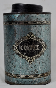
Tin Coffee and Chicory, circa mid to late 1900's
Chicory was mixed with coffee to reduce the amount of coffee bean required to be used. This coffee "substitute" was due to the repeated fluctuations in availability of coffee beans (and price fluctuations) in the USA in the late 1800s and early 1900s resulting in the search for substitutes and additives to bulk out the available supplies. This was especially so during times of the major World Wars. Chicory was an excellent choice of fillers as it did not greatly influence the strong coffee bean taste. The first choice in USA households was coffee not tea and the influence of the American servicemen's thirst for coffee was a major thrust into the Australian "colonial" preference for a "cuppa" tea. Rural areas took longer to acquire a coffee "break" but with more and more subliminal advertising through "American" films the rural regions developed a growing preference for coffee, however the tea break alias "smoko" has lingered on.This coffee and chicory blend tin container is very significant to the Kiewa Valley in that it demonstrates that even in rural regions of Australia tastes and drinking preferences have changed by subliminal advertising as time goes by. The American "influence" whether by the "invasion" of friendly troops during the major wars or the avalanche of "American films" has altered some of the "dinky-di" Australian "true blue" tastes and mores. The availability of "straight " coffee supplies to rural areas was also in proportion to the level of all weather transport routes. In the late 1800's and early 1900's road freight had to contend with dirt roads, flooded roads, bush fires and grazing cattle/sheep in rural areas. The easier access that city households had with regard to replenishment of food and drink products, up until the mid 1900's, was severely retarded in rural areas. This extensively rusted tin of "Bushells Blue Label" Coffee and Chicory has an octagonal shaped body with a "push/pull" lid(tin).Three sides has reproduced painted ladies in "Roman dress" ladies picking the coffee beans. There is no reproduction of any chicory roots. There are two "Indian dressed" field workers(pickers) with turban head dress. On one side of the tin is "directions of use, net weight and manufacturer details."Bushells Coffee & Chicory", "NET 1-Ib. weight", " No. 144" "Under the Pure Food Act N.S.W. 1938" "by Bushells Ltd. No 144"chicory / coffee drinks, tin hydrated drink, rural food and drink consumption patterns, tinned food and drink -
 Kiewa Valley Historical Society
Tin Coffee Cylindrical, circa mid to late 1900's
This "coffee" tin has by the "art deco" appearance its origins in the late 1950's to 1960's. This time period was one of accelerated growth both in the physical (housing) sense and the mental (new ideas and inventions) changes in "attitudes". These occurred more rapidly in cities but had its effects on the rural environment. The drinking of coffee was spurred on by easier distribution of imported food and drinks. Advertising by stronger radio links and then by television brought the variety of foods and drinks to semi isolated rural regions. The accessibility through greater information channels becoming available brought with it unbelievable ranges of goods and foodstuffs. Rural regions still relied on bulk supplies and relatively larger storage containers than those in cities. This "bulk" buying and storage "syndrome" was a lingering result of many years of "drought" periods when road transports met delays from flooded roadways in supplying population centres in the Kiewa Valley. The construction phases in building the SEC Vic Hydro electricity Scheme in the eastern sections of the Victorian Alps brought many changes to the quiet rural regions in the Kiewa Valley. Changes in population and social mores. The influx of a varied , mostly temporary, and "European flavoured cuisine" changes the "cuppa tea only" flavour to the have a "coffee break". The subliminal influence of the "American" films changed those children growing up in the post 1950s from the "English tea" to the "American coffee". This "Americanisation process has influenced not only rural Australia but also other areas throughout the world.This "insignificant" coffee tin is very significant as it demonstrates that the Kiewa Valley was becoming more accessible to reliable coffee supplies and general food items.The container was part of a "set" of containers that included tea, sugar,biscuits,flour, rice and other family condiments. This type of kitchen storage containers was brought about through changing patterns in tea and coffee useage and overall consumption. Household demands for faster "self help" cooking especially beveridges and the greater choice of kitchen "utensils" was brought on by easier access to products due to a lessening of the area's "isolation" by having a reliable (all weather) road system and an ever increasing population growth. The need for travelling goods/merchant supply caravans to service the area became a diminishing factor, as a result of the establishment of grocery stores in Tawonga and Mount Beauty in the supply of previously "hard to get" groceries. This transition was precipitated by the SEC Vic Hydro Scheme of the 1940's to 1960's which increased the valley's population level three fold.This cylindrical tin has a pull/push lid(for easy access to the contents). The container is labelled for "coffee" however it has no commercial manufacturer's label to establish that it was bought with coffee ingredients in it. The majority of the container's external surface has a "metallic" light blue colour with two sets of silver rings confining black (horizontal spotted) rectangles. "COFFEE" within an elongated spherical "art deco" four pointed banner of silver and black colouringkitchen containers, domestic food storage, bulk stocks of dried condiments -
 Kiewa Valley Historical Society
Postcard Circa 1950, Road to Bogong High Plains Kiewa Hydro Electric Project, Circa 1950's
This postcard was produced in the 1950's for the tourist trade in the Kiewa Valley and Alpine region. It encompasses the period when the State of Victoria was pressured by the ever increasing demand by industry and its population for electricity supplies. Hydro electricity was seen as an untapped natural resource to quench this demand. The Victorian Alps and the rivers flowing into its valleys was ideal for the construction of the Kiewa Hydro Electricity Scheme. The late 1940's saw the development of this scheme and the changing of sections of alpine landscape is covered by this and other postcards/pictures (tourists, construction workers, and established rural populations). This period in time was before the established wildlife and forest/nature groups became political activist who changed legislative acts to protect the environment.This rural region (Kiewa Valley/alpine plains) was at most only significant to a smaller group of winter sports, summer hikers/horse riders and rural farmers/graziers. The numbers of tourists and the increase in the local resident population was boosted by the construction of the Hydro Electricity Scheme. This influx to the regional population resulted in a corresponding diversity in services and brought about an environment that responded to a growing level of tourists and thereby permitting this industry to grow more rapidly than it would have naturally. This postcard details an attraction to the "cleaner" method of providing electricity. This postcard was purchased in 1950 by a surveyor at Landford's Gap.This black and white photograph on a Valentine's postcard is from a V2 Argus photograph.. It is on a 200g/m paper density photo side gloss. See 0480 (A) - (G) for other photos of similar postcards.In white lettering " ROAD TO BOGONG HIGH PLAINS KIEWA HYDRO-ELECTRIC PROJECT", V3secv, road making, victorian alps -
 Warrnambool and District Historical Society Inc.
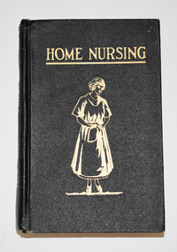
Book, W. Howard James, Home Nursing, 1923
A compendium for assisting mothers with children's ailmentsThis is a book of 508 pages. The cover is black with embossed patterns on the spine and gold lettering on the front cover and spine. The front cover has an embossed gold image of a woman. The pages are edged with a mottled pattern and contain printed text and black and white illustrations. There are four loose sheets; one is a flyer from the publisher and the others are advertisements.non-fictionA compendium for assisting mothers with children's ailmentsnursing, children's ailments -
 Warrnambool and District Historical Society Inc.
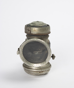
Functional object - Portable cycle carbide lamp, Powell & Hanmer, Birmingham, c 1920
This is a removable bicycle lantern probably dating from the first half of the 20th Century. It is a carbide lamp which was a popular form of lighting, particularly in rural areas. This item has no known local provenance but is retained as it is a good example of an early bicycle lamp.This is a brass and steel bicycle lamp. It has a circular glass front, a mechanism for attaching the lamp to the bicycle, a lighting adjustable wick and two glass panels on the side, one green and one red. There is a label with the manufacturer's name on the side. POWELL & HANMER "KINGFISHER" MAKERS, BIRMINGHAMvintage lighting, powell and hanmer -
 Warrnambool and District Historical Society Inc.
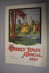
Magazine, Edgar Baillie for the Herald & Weekly Times, The weekly times annual 1929, 1929
This is the Weekly Times Annual of 1929. The Weekly Times newspaper was established in 1869 and was taken over by the Herald Newspaper group in 1892. It is a paper dedicated to rural affairs and is now the oldest rural newspaper in Australia. It has long been known as the ‘Bible of the Bush’. This annual contains many advertisements and photographs and sketches of places in rural Australia. It also has many articles, short stories and illustrations. Notable people that have contributed to this annual include Will Dyson (sketches), C.J.Dennis (poem), Vance Palmer (short story) and Norman Lindsay (reproduction of an art work). It also has a short story by Gertrude Hart, a novelist and short story writer. Her parents lived in Warrnambool in the 1850s (her father was the local Wesleyan minister) and her father retired to a place near to Warrnambool – Kirkstall. This attractive booklet is retained as an excellent example of Weekly Times Annuals in the past. It is also important because it has a short story by Gertrude Hart, a writer with connections to Warrnambool. This is a newspaper annual booklet of 68 pages. The cover has a buff-coloured background with a colour illustration of a stately building on the front with red printing and five colour photographs on the back page with black printing. The booklet has many advertisements, articles, short stories and photographs. Some pages are missing and a couple of pages are torn. the weekly times, gertrude hart, history of warrnambool -
 Warrnambool and District Historical Society Inc.
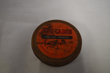
Tin, Log Cabin Tobacco, Late 20th century
The firm of W.D. & H.O. Wills is a British firm which first began making tobacco and cigarettes in Australia in 1913. This tin is a reminder of the times when many people (especially men in rural areas) used to make their own cigarettes (‘rolling your own’). This tin is retained as an example of a tobacco tin in the times when smoking was more popular in society and when pipe smoking and ‘rolling your own’ cigarettes were more common.This is a round tin, originally painted brown, with a vacuum-sealing lid and a red and black painted label on the lid. The label has an image of a farm scene with a log cabin. The base of the tin has a ridge in the middle on to which the lid fits. The tin is empty and very rusty. ‘Log Cabin Fine Cut Tobacco’ ‘To open insert coin under lid and twist’ tobacco tin, log cabin tobacco tin, vintage tobacco tin -
 Warrnambool and District Historical Society Inc.
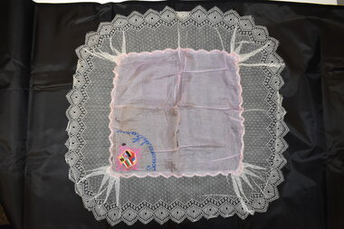
Souvenir Handkerchief, World War One
This item has been brought back to Australia by a returning soldier from World War One (1914-1918). At a time when France was completely disrupted by the ravages of war many French women, especially those in rural areas, earned a living by making souvenir pieces of embroidery to sell to soldiers in the Allied forces. These embroidered pieces took the form of postcards, doyleys, centerpieces, handkerchiefs etc. The items are noted for the handcraft skills shown by the makers and are prized by collectors today. This item, although fragile, is of considerable interest, firstly as an attractive embroidered piece and secondly, because of its association with World War One as an example of the souvenirs brought back from France to Australia by returning soldiers. This is an oblong-shaped handkerchief or doyley. It has a pink or mauve silk square in the middle with a coloured motif embroidered in one corner. This s a shield with representations of several European flags and embroidered wording underneath. The silk square is edged in a wave pattern in pink. The square has a white lace border. The item is slightly stained and has fold marks.Souvenir de Franceworld war one