Showing 187 items
matching slater house
-
 Glenelg Shire Council Cultural Collection
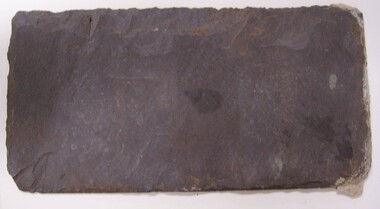
Functional object - Roof tiles, n.d
3 slate roofing tiles, various dimensions.roof, tiles, building, industry, trade -
Glenelg Shire Council Cultural Collection
Painting, S.S. Casino Off Cape Otway 1932, 1932
Depiction of a ship in heavy swells, tilting towards viewer. Ocean is deep blue green with white crests. Ship has a black and red hull, white cabin, white and black smokestack and red mast. Flags from mast and at rear of ship are flapping in strong wind. Sky is cloudy and grey, with lighter areas in cream and pale grey, darker areas in slate grey and blue. Framed in wooden frame with gold edging.Front: SS CASINO OFF CAPE OTWAY 1932 (lower left, paint) A.V. GREGORY 1932 (lower right, paint) -
 Glenelg Shire Council Cultural Collection
Domestic object - Slate Tile, n.d
... House. Slate tile used to cover lid of George V Monument time ...Displayed in History House.Slate tile used to cover lid of George V Monument time capsule (June 1911). -
Glenelg Shire Council Cultural Collection
Functional object - Slate, n.d
Found on shipwreck of the Nene Valley by an abalone diver c 1990Pre-drilled hand cut slate -
Glenelg Shire Council Cultural Collection
Functional object - Scales - gold weighing, c. 1854
Betty Vivian's maternal grandfather was a gold miner at Majorca, near Maryborough Vic and the scales belonged to himBrass scales for gold, in wooden box, with brass weights and gold ready-reckoner bookletgold mining, scales, gold rush -
Glenelg Shire Council Cultural Collection
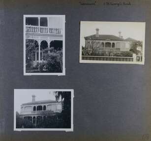
Photograph - Photograph - 'Stanton Drew', Portland, n.d
Stanton Drew was a two storey stucco rendered bluestone house was constructed in 1864 for Major Alexander Davidson, a Scottish born pastoralist who had earlier in 1848 settled on the Wando River near Casterton. Stanton Drew is a characteristic pattern book, regency gothic villa and virtually devoid of ornamentation save for unusually fenestrated bay windows and window label mouldings. Stanton Drew is a late example in Victoria of the primitive regency gothic style of villa architecture popularised by pattern books of the period 1840-60. The two storey house is an undistinguished design most notable for its associations with Western District pastoralist Alexander Davidson. No important historical associations are apparent, although the Davidson family lived in the residence until c.1908. Stanton Drew is in an extremely dilapidated state and has suffered badly form subsidence and lack of regular maintenance. The slate roof has been replaced with iron. The house was originally named Wando Villa by Davidson in memory of his time at Wando River. The house was renamed in 1938.Black and white photo. View of the front of 'Stanton-Drew' house, Portland.Back: 'STANTON-DREW, PORTLAND, VICTORIA, 1971' -handwritten black biro. Purple stamp 'ALEX PRIESTLEY BOX 155 PHONE 309 HEYWOOD VIC 3304'historic homestead, bluestone building, alexander davidson, pastoralist -
Glenelg Shire Council Cultural Collection
Photograph - Photograph - Unknown double story building, c. 1970
Photographic print of a rephotographed photograph. Image shows double storey building with pitched iron roof and fenced balcony on first floor, attached to single storey building with slate roof, 2 large multi-paned windows and partly open front door. Small child in open doorway, man in top hat and small boy on footpath. -
Glenelg Shire Council Cultural Collection
Functional object - Memo Slate - Peter F. Cram Chemist, Casterton, c. 1958
Peter Francis Cram was a pharmacist based in Casterton. In the 1966 Victorian government gazette he is listed as being at 83 Henty Street and having registered on 20 April 1955.Memo slate advertising Peter F. Cram, Chemist, Henty St., Casterton. Yellow plastic, red lettering, 1958 calendar on back. Slide-out white plastic slate, held between front and back by round metal stud.casterton, local business, industry, pharmacy, chemist -
 Victoria Police Museum
Police stations (Aitken's Gap)
Aitken's Gap, otherwise known as The Gap or Buttlejork, and 3km west of Sunbury, was established as a township in 1845. It is in the area which is now bordered by the Calder Highway and Gap Road. The village was named after John Aitken, a Port Phillip pastoralist who took up the Mount Aitken run in 1836. Aitken's Gap Police Barracks (in the District of Bourke) opened in 1853 and was staffed by two Mounted Constables and one Foot Constable. The gaol (used to house prisoners and also gold en route to Melbourne) was built in 1857 from bluestone quarried in the area. The roof was made of slate. In 1861 it was staffed by 1 Mounted Senior Constable and 1 Foot Constable. The Barracks closed in 1863 when the Bendigo rail line was completed and the gold was transported to Melbourne by rail. All the buildings, except the gaol, were moved to Sunbury. The land was sold in 1870 and in 1989 the current owner donated the building to the Sunbury Police. The original building was dismantled, restored and rebuilt outside Sunbury police station.15 colour photos and 1 black and white photopolice stations; aitken's gap police station -
 Victoria Police Museum
Police Stations (Ararat)
Ararat is a city in south-west Victoria, Australia, about 198 kilometres west of Melbourne, on the Western Highway on the eastern slopes of the Ararat Hills and Cemetery Creek valley between Victoria's Western District and the Wimmera. It is named after Mount Ararat 10 kilometres south-west of the town. A police station opened in Ararat in 1859, though there was a police presence in the area formerly known as Cathcart, Canton Lead and later Mount Ararat. In 1861 staff consisted of 1 Superintendent, 2 Mounted Constables, 1 Sergeant 2nd class, 1 Senior Constable, 8 Constables. The police reserve was on land bounded by Ligar Street, Barkley Street, Ingor Street and High Street. In 1930 the police station was described as a six-room brick dwelling with a slate roof, situated on one quarter acre of land. There was also a bathroom, wash-house, pantry, office, muster room and quarters for a single constable, stables with three stalls, and a lock-up consisting of two six-person cells. Later residences were located at 3 Ligar Street (brick veneer with a tile roof); 32A High Street (brick veneer with tile roof); and 3 Tobin Street (wood with an iron roof). A new, purpose built police station was opened in October 2010 at 77 Barkly Street. The Ararat Police District was reformed into the Wimmera Police District in 1870. Ararat Police Station became part of "R" (Glenelg) District in January 1948 and "M" (Highlands/Wimmera) District from March 1990. A list of police stationed at Ararat from 1903 - 1930 is available from the Victoria Police Museum8 photos comprising: 7 black & white photos 1 colour photopolice stations; ararat police station -
 Victoria Police Museum
Police Stations (Ascot Vale)
Ascot Vale is an inner suburb 6 km north-west of Melbourne, Victoria, Australia in the local government area of the City of Moonee Valley. Ascot Vale police station was opened on 31 October 1887 in the Melbourne Police District. From 1900-1905 it was located at 54 Parade, Ascot Vale; from 1910-1925 at 71 St Leonards Road; from 1930-1953 at 37 St Leonards Road. In 1953 it was relocated to government owned premises at 111 Union Road until the police station closed on 1st May 1970 and the Sub-district was divided between Flemington and Moonee Ponds police stations. The former police station was used by the Crime Car Squad until about 1987 when the premises were damaged by fire. The police station at 37 St Leonards Road was described as a six-roomed brick dwelling with slate and iron roof on land measuring 150' x 50'. There was also a bathroom and W.C., wash-house, office and lock-up with one cell. It was staffed by one second-class sergeant and four foot constables. The purpose-built police station at 111 Union Road included a four-roomed residence with the exterior clad in rough cast Conite and a tile roof. There was also a kitchen, bathroom, laundry and separate garage. 4 black and white photospolice stations; ascot vale police station -
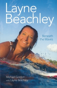 Australian National Surfing Museum
Book, Ebury Press/Random House Australia, Layne Beachley - Beneath the Waves
Authorised biography on Australia's Layne Beachley the most successful female surfer in the history of the sport. This book follows her story as she strives to overcome the obstacles of injury, chronic fatigue and family tragedy to achieve success in the male dominated sport of surfing.The first biography on seven times, World Surfing Champion Layne Beachley, one of the most succesful female athletes in the history of modern sport. Written by award winning journalist and surfer Michael Gordon.Colour cover with a close up photographic image of a smiling Layne Beachley paddling into a wave.Book title, author name.layne beachley, kelly slater, stephanie gilmore, lisa anderson, michael gordon, ken bradshaw, kirk pengilly -
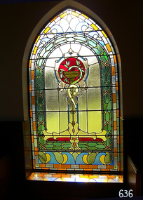 Flagstaff Hill Maritime Museum and Village
Artwork, other - Window, circa 1928
This religiously themed window is situated in the western (weather) wall of the St. Nicholas Mission to Seamen’s Church building in the Flagstaff Hill Maritime Village. It was crafted circa 1928. ABOUT THE WINDOW This window, once known as the Dr Connell Memorial Window, was a feature of an external wall adjacent to the Women’s Children’s Wards of Warrnambool Hospital. Honorary Doctors had played a significant role in the operation of the hospital between the years 1900 to 1939. One of these doctors was Dr. Connell, who passed away in 1928. The green glass plaque is also a registered object in Flagstaff Hill's Collection. Its inscription dedicates the window to Dr. Connell. The inscription reads: “A tribute to Egbert John Connell M.B.B.S. who for 30 years rendered devoted and valuable service to this institution. Obiit April 4th 1928 A.D." A paragraph in the book ‘A History of the Warrnambool Base Hospital’ by Forth and Yule describes the role of the Honorary Doctors - “At the start of the period the senior-part time medical officer was replaced by the junior resident medical officer and control of beds and the right to operate were given to the honorary medical officers...and these men dominated the Warrnambool medical world in the years before the Second World War.” Dr. Connell leased ‘Ambleside’, 192 Koroit Street, in the early 20th century, following Dr Teed who had previously run his medical practice there. In 1914 Dr Connell purchased the property and continued his private practice there until his death in 1928. He also took a prominent part in hospital work, both as physician and surgeon, and often acted as spokesmen for the Honorary Doctors. According to colleague Dr. Horace Holmes’ subsequent notes, it was after the close of the First World War, and the following years of the world-wide pneumonic influenza epidemic, that Dr. Connell himself contracted pneumonia and died. His family and friends then recognised his work by gifting the memorial window in his honour to the Hospital. By the mid-1970s the old wards at the hospital had been replaced and there was no obvious place for the window. Discussions between the previous and past Hospital managers, the Anglican Diocese, and Flagstaff Hill Planning Board, led to its installation in its present position in St Nicholas Seamen’s Church and the memorial plaque was later installed beside the window. St NICHOLAS SEAMEN’S CHURCH, Anglican Church Flagstaff Hill’s Mission to Seamen was opened in 1981. Its conception was partly motivated by the offer of Stained Glass Memorial Windows from the local Warrnambool and District Base Hospital, which was undergoing multi-storey development in the late 1960’s and early 1970’s. The Manager/Secretary at the time was keen to see the historical windows installed in an appropriate location. The chapel was designed by a local architectural draftsman in conjunction with members of the Planning Board of Flagstaff Hill, and built by Mr Leon Habel. The vision of the designers included the hope that the church be used for formal worship such as weddings and funeral, and for multi-denominational special services such as War commemorations. The design is based on the ‘Mission to Seamen’ buildings in both Portland and Port Melbourne. These types of buildings were often erected to house social and worshipful activities for seamen. The materials used in the building include sandstone recycled from nineteenth-century buildings demolished in Warrnambool and American slate tiles retrieved from the 1908 wreck of the FALLS OF HALLADALE. Most of the chapel furnishings came from the Williamstown Missions to Seamen, which was consecrated in 1946 but later decommissioned. These artefacts range from the altar cloth to the hymn board and include a visually stunning round stained glass widow called ‘Christ Guiding the Helmsman’. However the provenance of this particular artefact, large western window, is local. This stained glass memorial window is of local, historical and social significance, linking local history and heritage with one of Warrnambool's doctors, Dr. Egbert John Connell (d. 1928), who gave 30 years of dedicated, medical service to the local citizens.Stained glass leadlight window in Gothic arched metal frame with six horizontal reinforcing rods. Image depicts a golden flat-bowled baptismal font on a slender stand with foliage proceeding from it. The image is internally framed by a Roman arch of coloured glass and surrounding rectangular and breaking-wave shapes. (The window was previously known locally as the Dr. Connell Memorial Window and a plaque dedicated to Dr. Connell is catalogued separately. See Context notes for details.)flagstaff hill, warrnambool, shipwrecked coast, flagstaff hill maritime museum, maritime museum, shipwreck coast, flagstaff hill maritime village, great ocean road, chapel window, stained glass window, warrnambool and district base hospital, st nicholas mission to seamen’s church, williamstown mission to seamen, dr egbert connell, ambleside warrnambool, leon habel builder, falls of halladale slate, memorial window, commemorative window, dr connell -
 Eltham District Historical Society Inc
Folder, 2 Metery Road, Eltham South
Morrison Kleeman Real Estate sales information material for the Alistair Knox designed house known as the Zull House. "Nestled into a private hill of more than an acre of established gardens, shady ornamental gardens, shady ornamental grapesvines and gumtrees, sounds of bellbirds engulf this Alistair Knox home of special ambience. This home features the textures and colours of nature, home made Hawthorn bricks, flooirng slate from the old St Kilda baths and recycled timbers..." The property was sold Feb 26, 2004 (Source: realestateview.com.au) Knox was a pioneer in the use of mudbricks and recycled materials and is significant to his contribution of this style of architecture in Eltham and the wider Shire of Nillumbik.1 documents, 2 pages A4 gayle blackwood collection, houses, morrison kleeman real estate, metery road, eltham south, alistair knox, zull, st kilda baths -
 Glen Eira Historical Society
Album - Album page, Glenfern, Inkerman Street, Circa 1972
This photograph is part of the Caulfield Historical Album 1972. This album was created in approximately 1972 as part of a project by the Caulfield Historical Society to assist in identifying buildings worthy of preservation. The album is related to a Survey the Caulfield Historical Society developed in collaboration with the National Trust of Australia (Victoria) and Caulfield City Council to identify historic buildings within the City of Caulfield that warranted the protection of a National Trust Classification. Principal photographer thought to be Trevor Hart, member of Caulfield Historical Society. Most photographs were taken between 1966-1972 with a small number of photographs being older and from unknown sources. All photographs are black and white except where stated, with 386 photographs over 198 pages.From Victorian Heritage Database citation for Glernfern H0136 https://vhd.heritagecouncil.vic.gov.au/places/57 (as at 23/10/2020) Glenfern was built on spacious grounds at the corner of Inkerman and Hotham Streets, East St Kilda in two main stages in 1857 and 1876. From 1876 to 1984 Glenfern had only two owners, including the well known Melbourne family of artists, the Boyds. The property was bequeathed to the National Trust of Australia (Victoria) in 1984 and has remained in their ownership. The original Glenfern allotment was bought by John Bakewell in 1856 and sold the following year to Francis McDonnell, a prominent Melbourne investor. By 1858, the house, rated as the most valuable in Caulfield, had been built on the site. Due to financial difficulties, McDonnell offered a number of properties for sale in 1860, including Glenfern. It was not sold at this stage, but subsequently mortgaged in 1862. In 1866 Thomas Watson purchased the property and lived there until 1876 when it was sold to Captain John T. T. Boyd and his wife, Lucy, founders of the Boyd dynasty of artists, musicians, writers and architects. The Boyd family, including twelve children, lived there until 1907, with Lucy Boyd retaining ownership after her husband's death in 1891. In 1907 the property was subdivided and the greatly reduced Glenfern portion was purchased by the Ostberg family, who lived there from 1915. In the latter years of Boyd family ownership and the Ostberg ownership, Glenfern had several tenants and was run as a school on two occasions. The Ostberg family occupancy continued until the death of Miss Amy Ostberg in 1984. From 1929 the property was listed as Glenfern Flats, necessitating various internal alterations over a period of time. The original two storey house, attributed to architect Charles Laing, was extended for the Boyd family in 1876, by architect M. Hennessy. This comprised the addition of a two storey wing to the south of the existing building. Stables were built in 1884 by the architects Smith and Johnson and other outbuildings, since removed, were recorded on the site. The gardens were developed from the establishment of the estate and remnants of early plantings, exotic trees in particular, are evident. Various additions and alterations were made to the house in the twentieth century and a separate block of flats was built on the southern boundary in c1964. Glenfern is a two storey picturesque Gothic house of stuccoed brick with steep, gabled slate roofs, elaborate bargeboards and chimneys of conjoined stacks set diagonally. The original, asymmetrically planned L-shaped house, containing the principal rooms and a rear wing, was designed with two main facades facing north and west. The north facade contains an unusual recessed pointed arch bay formed between twin chimney flues. Internally cedar joinery includes an unusual set of double doors between the drawing room and parlour, the centre pair of which fold back and then slide into the walls. Detailing of the 1876 additions copied that of the original house, including the bargeboards, chimneys and western verandah. Ownership of Glenfern passed to the National Trust of Australia (Victoria) in 1984 and in 2002 transformation of the property into a Centre for the Arts and Culture commenced. This began with the establishment of an Artist-in-residence programme, followed by the Glenfern Writers Centre. Restoration and renovation of the building has been undertaken concurrently with the establishment of this centre. How is it significant? Glenfern, East St Kilda is of architectural and historical significance to the State of Victoria. Why is it significant? Glenfern is of architectural significance as an unusually intact and rare example of the picturesque domestic Gothic Revival house in Victoria. Of particular note are the clustered chimneys, bargeboards and twin arched chimney flues and the folding/sliding cedar doors between the principal rooms. It is significant as an important work of the prominent Melbourne architect, Charles Laing. Glenfern is of historical significance for its connection with the distinguished Victorian Boyd family. It has been recorded in a painting by Emma Boyd, wife of Arthur, in 1885 and in print by writer, Martin Boyd in 1952. Glenfern is of historical significance due to its ownership by only two families from 1876; firstly the Boyds until 1907 and the Ostbergs until 1984. Of note is the resistance to redevelopment in the latter half of the twentieth century and the subsequent survival of the 1907 Glenfern estate.Page 98 of Photograph Album with two photographs (one square and one landscape) of views of Glenfern.Handwritten: "Glenfern" 417 Inkerman Street [top right] / 98 [bottom right]trevor hart, east st kilda, garden, pitched roof, glenfern, hotham street, boyd family, 1850's, 1860's, 1870's, john bakewell, francis mcdonnell, thomas watson, lucy boyd, glenfern flats, charles laing, m. hennessy, smith and johnson, stables, gothic, stuccoed brick, gabled slate roofs, elaborate bargeboards, asymmetrical, cedar joinery, verandah, national trust of australia, centre for the arts and culture, artist-in-residence, glenfern writers centre, gothic revival, clustered chimneys, emma boyd, inkerman street, north caulfield, captain john boyd, artists, writers, st kilda east, national trust of australia (victoria), caulfield, amy ostberg, architects, m hennessy, doors, chimneys, martin boyd, arthur boyd, ostberg family -
 Glen Eira Historical Society
Album - Album page, Nithsdale now Five Way Hill, Kambrook Road, Circa 1972
This photograph is part of the Caulfield Historical Album 1972. This album was created in approximately 1972 as part of a project by the Caulfield Historical Society to assist in identifying buildings worthy of preservation. The album is related to a Survey the Caulfield Historical Society developed in collaboration with the National Trust of Australia (Victoria) and Caulfield City Council to identify historic buildings within the City of Caulfield that warranted the protection of a National Trust Classification. Principal photographer thought to be Trevor Hart, member of Caulfield Historical Society. Most photographs were taken between 1966-1972 with a small number of photographs being older and from unknown sources. All photographs are black and white except where stated, with 386 photographs over 198 pages. Glen Eira Heritage Management Plan (1996) by Andrew Ward and Associates - Vol 3 "Nithsdale", built for J.S. Crouchin 1858 and extended in 1885 with a tower and associated rooms, survives as testimony to the nineteenth century occupation of the vicinity of the Kambrook/Glen Eira Road intersection. Caulfield's Building Heritage by Dr Geulah Solomon, Vol 1 p49 records it as a small Victorian mansion home on bluestone foundations of Italianate style with a tower. Built for J S Chambers circa 1860, it was built in stages and then the land subdivided in the 1920s. Other owners include Adolph F Brockhoff (of Brockhoff Biscuits company). Names used besides Nithsdale have been Bundoora and Five Way Hill. Page 102 of Photograph Album with four photographs (three landscape and one portrait) of Nithsdale, now known as Five Way Hill. Three views of the tower and one of the house.Handwritten: "Nithsdale" now "Five Way Hill" Kambrook road [top right] / CNR KAMBROOK AND GLENEIRA ROADS [under bottom right photo] / 102 [bottom right]trevor hart, north caulfield, victorian, mid victorian, late victorian, tower, j.s. crouchin, 1850's, 1880's, italianate, rendered, five way hill, nithsdale, slate roof, plaster arches, ornamental columns, triangular pediment, ornamental parapet, cast iron balconies, kambrook road, glen eira road, t crouch, j s crouchin, mansions, j s chambers, bluestone foundations, land subdivision, adolph f brockhoff, bundoora, house names -
 Glen Eira Historical Society
Album - Album page, Kambrook Road, Circa 1972
This photograph is part of the Caulfield Historical Album 1972. This album was created in approximately 1972 as part of a project by the Caulfield Historical Society to assist in identifying buildings worthy of preservation. The album is related to a Survey the Caulfield Historical Society developed in collaboration with the National Trust of Australia (Victoria) and Caulfield City Council to identify historic buildings within the City of Caulfield that warranted the protection of a National Trust Classification. Principal photographer thought to be Trevor Hart, member of Caulfield Historical Society. Most photographs were taken between 1966-1972 with a small number of photographs being older and from unknown sources. All photographs are black and white except where stated, with 386 photographs over 198 pages. https://vhd.heritagecouncil.vic.gov.au/places/43737 - re 26 Kambrook Road and 345 Balaclava Road corner building: A prominently situated two-storeyed complex of late Victorian buildings consisting of "Wybar's Buildings" occupying the Balaclava Road/ Kambrook Road corner and the "Caulfield Bakery" facing Kambrook Road, separated by a driveway from a single storeyed shop. The main building has a comer splay and balustraded parapet with curved pediments, the words "Wybar's Buildings 1887" having been obliterated but "Caulfield Bakery 1887" with the characteristic wheatsheaf surviving in raised cement work. The walls are stuccoed and richly ornamented with bracketed cornices and keystones with masks extending to the Bakery. The main building is further distinguished by the Masonic symbol of the mason's dividers in the pediment whilst the upper level of the bakery is in overpainted brickwork. The single storeyed shop incorporates the bracketed cornice and consoles characteristic of the main buildings and is in other respects a utilitarian structure. https://vhd.heritagecouncil.vic.gov.au/places/35413 - re 16 Kambrook Road A small late Victorian Italianate villa distinguished by its parapeted window bays either side of a small verandah with encaustic tiled floor. The parapets are balustraded with console enrichment and glazed tiles, the stuccoed surfaces being unpainted. Ornamentation is in other respects undistinguished. https://www.gleneira.vic.gov.au/services/planning-and-building/heritage/heritage-management-plan - re 9-11 Kambrook Road ... they demonstrate most of the commonly employed aesthetic devices characteristic of the Italianate Style including patterned brickwork, patterned slate roofs, cast iron lace verandahs, ornamental stucco work and ashlar boards...https://vhd.heritagecouncil.vic.gov.au/places/43737 - 345 Balaclava and 26 Kambrook Roads HO91 in City of Glen Eira "Wybar's Buildings" at the corner of Balaclava Road and Kambrook Road are important as a prominent late Victorian commercial development incorporating a variety of activities including a bakery and possibly a coffee palace, the latter understood to be unique within the municipality, but characteristic of the period. It is a rare complex of its type in Caulfield and is important also as evocative evidence of the late Victorian Land Boom and the creation of a small now defunct commercial centre at this location by the George Wybrow. https://vhd.heritagecouncil.vic.gov.au/places/35413 - 16 Kambrook Road HO121 in City of Glen Eira ''Hollywood'' at 16 Kambrook Road is of architectural interest for its pavilions which retain their unpainted parapets and ornamental tiles in the manner of other less imposing examples in the immediate locality possibly linked with the builder George Wybar and his son, who undertook substantial projects nearby. Its association with James Yorston, presumably is Yorston of Dickson and Yorston, important builders and estate developers at Caulfield during the Inter war period is of interest. https://www.gleneira.vic.gov.au/services/planning-and-building/heritage/heritage-management-plan - re 9-11 Kambrook Road HO152 Normanby Road/Kambrook Road, Caulfield North Statement of Significance: The Precinct is historically significant for its capacity to demonstrate standards of design and building construction in this part of the municipality during the late Land Boom years and especially just prior to the bank collapse of 1891. The housing stock is representative of the standards of amenity excepted by the middle classes of Melbourne society at the time, including artists, (horse) trainers, jockeys, managers, travellers, journalists and the like, also having a functional link with the activities of the Caulfield Racecourse which forms an important element in the history of the Municipality. The row of attached pairs at 5-11 Kambrook Road and 53-67 Kambrook Road is especially significant in this respect in that the narrow allotments are indicative of the owner/developer’s determination to maximise profits at the height of the Land Boom in 1891...Page 104 of Photograph Album with four photographs (landscape) of three different properties on Kambrook Road.Handwritten: Kambrook Road [top right] / WYBAR'S BUILDING 1887/ INC CAULFIELD BAKERY / [under top right photo] / 16 KAMBROOK ROAD / 1970 HIRST MRS J.N.[under bottom left photo] / 11-9 KAMBROOK ROAD / 1970 9-BUCKLAND MRS L.A / 11- ATKINS MRS N.E. [under bottom right photo] / 104 [bottom right]trevor hart, kambrook road, victorian, caulfield north, parapets, wybar's buildings 1887, caulfield bakery 1887, architectural features, painted bricks, balaclava road, victorian italianate style, houses, bay windows, verandahs, glazed tiles, shops, george wybar, builders, james yorston, dickson and yorston, j n hirst, l a buckland, n e atkins, patterned slate roofs, patterned bricks, cast iron work, attached houses -
 Glen Eira Historical Society
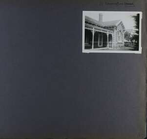
Album - Album page, Leamington Crescent, Circa 1972
This photograph is part of the Caulfield Historical Album 1972. This album was created in approximately 1972 as part of a project by the Caulfield Historical Society to assist in identifying buildings worthy of preservation. The album is related to a Survey the Caulfield Historical Society developed in collaboration with the National Trust of Australia (Victoria) and Caulfield City Council to identify historic buildings within the City of Caulfield that warranted the protection of a National Trust Classification. Principal photographer thought to be Trevor Hart, member of Caulfield Historical Society. Most photographs were taken between 1966-1972 with a small number of photographs being older and from unknown sources. All photographs are black and white except where stated, with 386 photographs over 198 pages. Page 118 Photograph Album with one photograph (landscape) of a brick house at Leamington Crescent.Handwritten: 21 Leamington (Street) [crossed out] / Crescent [top right] / 118 [bottom right]trevor hart, verandah, arched windows, leamington crescent, ornate cornerstone, slate roof, triple windows, decorative brackets, eave brackets, leamington street, caulfield east, cast iron frieze, victorian architectural style, cast iron work, polychrome bricks -
 Glen Eira Historical Society
Album - Album page, Malakoff Street, Circa 1972
This photograph is part of the Caulfield Historical Album 1972. This album was created in approximately 1972 as part of a project by the Caulfield Historical Society to assist in identifying buildings worthy of preservation. The album is related to a Survey the Caulfield Historical Society developed in collaboration with the National Trust of Australia (Victoria) and Caulfield City Council to identify historic buildings within the City of Caulfield that warranted the protection of a National Trust Classification. Principal photographer thought to be Trevor Hart, member of Caulfield Historical Society. Most photographs were taken between 1966-1972 with a small number of photographs being older and from unknown sources. All photographs are black and white except where stated, with 386 photographs over 198 pages. Page 126 of Photograph Album with two landscape photographs of a Victorian house.Handwritten: Malakoff Street [top right] / 126 [bottom right]trevor hart, bracketed eaves, slate roof, bay windows, decorative brackets, verandah, caulfield north, malakoff street, cast iron work, stairs, victorian style -
 Glen Eira Historical Society
Album - Album page, Labassa, 4 Manor Grove, Circa 1972
This photograph is part of the Caulfield Historical Album 1972. This album was created in approximately 1972 as part of a project by the Caulfield Historical Society to assist in identifying buildings worthy of preservation. The album is related to a Survey the Caulfield Historical Society developed in collaboration with the National Trust of Australia (Victoria) and Caulfield City Council to identify historic buildings within the City of Caulfield that warranted the protection of a National Trust Classification. Principal photographer thought to be Trevor Hart, member of Caulfield Historical Society. Most photographs were taken between 1966-1972 with a small number of photographs being older and from unknown sources. All photographs are black and white except where stated, with 386 photographs over 198 pages. HISTORY:-- From Victorian Heritage Database citation for Labassa https://vhd.heritagecouncil.vic.gov.au/places/278 as at (26/10/2020) Labassa, Caulfield is one of Melbourne's most lavishly decorated nineteenth century mansions. It resulted from the extensive remodelling in 1890, of an earlier house, known as Sylliott Hill, which was begun in 1862-3 for lawyer, Richard A. Billing. The land at the corner of Balaclava and Orrong Roads was first acquired in 1854 by William Lyall, transferred to his partner, John Mickle, in 1859, who also acquired the adjoining allotment in Balaclava Road, and the three allotments were conveyed to Billing. His first eight-roomed house was extended significantly in 1873 into a twenty-roomed house by architects Crouch and Wilson, who were possibly also responsible for the first house. This reflected Billing's success as a barrister, and he resided at this property until his death in 1882. In 1883 prominent Melbourne businessman, Alexander William Robertson, leased the Sylliott Hill property from Billing's widow, and in 1885 he purchased the adjoining allotment in Balaclava Road. He purchased the Billing's property in 1887 and renamed the 6.31 hectare property, Ontario. In 1889-90, Robertson commissioned the German born architect, John A. B. Koch, to extensively remodel the house into a thirty-five roomed mansion. The existing house was extended and altered, largely resulting in the nineteenth century mansion as it now appears. After Robertson's death in 1896, the house was tenanted until it was eventually sold to the mining millionaire, John Boyd Watson, in 1904. He renamed the property Labassa and carried out repair and re-decoration work to the house. In the early twentieth century, many large estates were subdivided into smaller allotments as the demand for land grew and it became difficult to maintain such large estates. After Watson's death in 1911, portions of the Labassa estate were offered for sale, with Mrs Watson retaining a 1.73 hectare portion containing the house. In 1913 forty-six allotments were auctioned at Labassa Estate, with the formation of Labassa Grove and Ontario Street to the east of the property. Labassa was first recorded as containing flats in 1923 and in the late 1920s, the owner, Robert Hannon, built a red brick block of flats adjacent to the house. Subdivision continued, until the National Trust of Australia (Victoria) purchased the house in 1980 and subsequently purchased adjoining sites, one to the south-east in 1984 (house demolished in 1988) and to the west in 1988. Labassa as it now stands is substantially as it appeared when Koch completed the work in 1890. The original two storey house was transformed into a French Renaissance style mansion, with the addition of a two level L-shaped arcaded verandah and two prominent terminating bays to the south and the east. The building is of unpainted cement render with dressed bluestone plinths, balustraded parapet and steep, slate covered, flat topped mansard roofs behind. A truncated conical roof is a feature of the south bay and a helmeted head is incorporated in the parapet over the east bay. The main south and east facades incorporate many cast cement details, including sculptures, elaborate cornices, swagged Corinthian columns and caryatid consoles flanking the entrance porch, as well as pink marble panels and imitation marble, or scagliola, on curved surfaces. At the rear of the building is a two storey wing and a single storey cottage, the former being connected to the main house by a tower. This section of the house was constructed in 1873. The estate at its peak included stables (1873), conservatory (probably 1890) and a tennis pavilion (probably 1890). All of these outbuildings survive, with the stables and conservatory being converted for residential use after 1922. Internally a range of decorative treatments remain from the late nineteenth century and the early twentieth century, both from the Robertson and Watson periods of occupancy. These include wallpapers, ceiling decoration, chimney pieces, mouldings, joinery and decorative glass. From Victorian Heritage Database citation for H0135 Labassa 2/2A Manor Grove Caulfield North https://vhd.heritagecouncil.vic.gov.au/places/278 as at (26/10/2020) HOW IS IT SIGNIFICANT? Labassa, Caulfield is of architectural, aesthetic and historical significance to the State of Victoria. WHY IS IT SIGNIFICANT? Labassa, Caulfield is of architectural significance as the most prominent example of a small number of houses built in Australia in the French Renaissance style. It is of further note due to the German interpretation of the style and the use of Hellenistic sources, via Germany. It is exceptional for its lavish treatment externally, including marble, scagliola, caryatids, swagged columns, mansard roofs and ornamental cresting. Labassa is of architectural significance as the most important surviving example of German architect, John Koch's domestic work. He undertook a large variety of work in Melbourne, including a number of houses, however Labassa is the most lavish example of his work. Labassa is of aesthetic significance for its outstanding assemblage of late nineteenth and early twentieth century European style interior decoration, which remain remarkably intact. These include a trompe l'oeil ceiling, painted ceilings, embossed imitation leather and other papers, chimney pieces, ceramic tilework, oak parquetry and stained glass, including a tripartite window by Ferguson and Urie, probably dating from the 1873 period. Labassa is of historical significance as an illustrative example of the wealth acquired by a number of prominent Victorian families in the second half of the 19th century. The early development of the property, Sylliott Hill, was due to the wealth acquired by Richard Billing, barrister and fifth Victorian to be appointed Queen's Counsel in 1878. The significant development in 1890 of Ontario, is illustrative of the wealth of Alexander Robertson, a partner in Cobb and Co., a director of Goldsborough Mort & Co., and a pastoral speculator. John B. Watson, whose father had acquired great wealth from the goldfields of Bendigo and subsequently invested in city and country properties, was the third resident to impact on the house, particularly the interiors. The Labassa estate is of historical significance as an illustrative example of the development that occurred in such suburbs as Caulfield in the 1880s due to the land boom, its proximity to Melbourne and the establishment of the Melbourne to Gippsland railway in 1879. It is also illustrative of an estate which succumbed to the pressures of subdividing in the early twentieth century, as properties became difficult to maintain and demand for land close to the city grew. It was typically divided into flats in the 1920s and was used as such for about sixty years. It is of historical significance for its associations with the remnants of the earlier estate which remain extant. These include the stables, conservatory (H2005) and tennis pavilion which all remain on separate sites. Also significant are the remains of early electrical wiring and fittings. Labassa was one of the first houses in Caulfield to be electrified and some of the original wires remain. [Online Data Upgrade Project 2004]Page 128 of Photograph Album with four photographs (two portrait and two landscape) of Labassa.Handwritten: "Labassa" 4 Manor Grove [top right] / Neg 232 8 Oct 1966 [under bottom right photo] / 128 [bottom right]trevor hart, bracketed eaves, slate roof, bay windows, decorative brackets, caulfield north, labassa, richard a. billing, balaclava road, orrong road, sylliott hill, william lyall, crouch and wilson, alexander william robertson, ontario, 1880's, john a. b. koch, mansion, john boyd watson, labassa grove, french renaissance style, l-shaped arcaded verandah, bluestone plinths, balustraded parapet, flat topped mansard roofs, conical roof, elaborate cornices, corinthian columns, caryatid consoles, marble panels, imitation marble, scagliola, tower, conservatory, stables, tennis pavilion, mouldings, decorative glass, caryatids, swagged columns, ornamental cresting, trompe l'oeil ceiling, embossed imitation leather, oak parquetry, stained glass, tripartite window, triple window, ferguson and urie, 1870's, flats, 1920's, electric wiring, 1860's, verandahs, curved windows, arched windows, italianate, terraces, gargoyles, ornamentation, ornate entrance, la bassa, manor grove, st kilda east, victorian, cast iron work, john koch, richard billing, architects, electrification, john mickle, land subdivision, mrs watson, labassa estate, robert hannon, national trust of australia (victoria), sculpture -
 Glen Eira Historical Society
Album - Album page, Labassa, 4 Manor Grove, Circa 1972
This photograph is part of the Caulfield Historical Album 1972. This album was created in approximately 1972 as part of a project by the Caulfield Historical Society to assist in identifying buildings worthy of preservation. The album is related to a Survey the Caulfield Historical Society developed in collaboration with the National Trust of Australia (Victoria) and Caulfield City Council to identify historic buildings within the City of Caulfield that warranted the protection of a National Trust Classification. Principal photographer thought to be Trevor Hart, member of Caulfield Historical Society. Most photographs were taken between 1966-1972 with a small number of photographs being older and from unknown sources. All photographs are black and white except where stated, with 386 photographs over 198 pages. HISTORY:-- From Victorian Heritage Database citation for Labassa https://vhd.heritagecouncil.vic.gov.au/places/278 as at (26/10/2020) Labassa, Caulfield is one of Melbourne's most lavishly decorated nineteenth century mansions. It resulted from the extensive remodelling in 1890, of an earlier house, known as Sylliott Hill, which was begun in 1862-3 for lawyer, Richard A. Billing. The land at the corner of Balaclava and Orrong Roads was first acquired in 1854 by William Lyall, transferred to his partner, John Mickle, in 1859, who also acquired the adjoining allotment in Balaclava Road, and the three allotments were conveyed to Billing. His first eight-roomed house was extended significantly in 1873 into a twenty-roomed house by architects Crouch and Wilson, who were possibly also responsible for the first house. This reflected Billing's success as a barrister, and he resided at this property until his death in 1882. In 1883 prominent Melbourne businessman, Alexander William Robertson, leased the Sylliott Hill property from Billing's widow, and in 1885 he purchased the adjoining allotment in Balaclava Road. He purchased the Billing's property in 1887 and renamed the 6.31 hectare property, Ontario. In 1889-90, Robertson commissioned the German born architect, John A. B. Koch, to extensively remodel the house into a thirty-five roomed mansion. The existing house was extended and altered, largely resulting in the nineteenth century mansion as it now appears. After Robertson's death in 1896, the house was tenanted until it was eventually sold to the mining millionaire, John Boyd Watson, in 1904. He renamed the property Labassa and carried out repair and re-decoration work to the house. In the early twentieth century, many large estates were subdivided into smaller allotments as the demand for land grew and it became difficult to maintain such large estates. After Watson's death in 1911, portions of the Labassa estate were offered for sale, with Mrs Watson retaining a 1.73 hectare portion containing the house. In 1913 forty-six allotments were auctioned at Labassa Estate, with the formation of Labassa Grove and Ontario Street to the east of the property. Labassa was first recorded as containing flats in 1923 and in the late 1920s, the owner, Robert Hannon, built a red brick block of flats adjacent to the house. Subdivision continued, until the National Trust of Australia (Victoria) purchased the house in 1980 and subsequently purchased adjoining sites, one to the south-east in 1984 (house demolished in 1988) and to the west in 1988. Labassa as it now stands is substantially as it appeared when Koch completed the work in 1890. The original two storey house was transformed into a French Renaissance style mansion, with the addition of a two level L-shaped arcaded verandah and two prominent terminating bays to the south and the east. The building is of unpainted cement render with dressed bluestone plinths, balustraded parapet and steep, slate covered, flat topped mansard roofs behind. A truncated conical roof is a feature of the south bay and a helmeted head is incorporated in the parapet over the east bay. The main south and east facades incorporate many cast cement details, including sculptures, elaborate cornices, swagged Corinthian columns and caryatid consoles flanking the entrance porch, as well as pink marble panels and imitation marble, or scagliola, on curved surfaces. At the rear of the building is a two storey wing and a single storey cottage, the former being connected to the main house by a tower. This section of the house was constructed in 1873. The estate at its peak included stables (1873), conservatory (probably 1890) and a tennis pavilion (probably 1890). All of these outbuildings survive, with the stables and conservatory being converted for residential use after 1922. Internally a range of decorative treatments remain from the late nineteenth century and the early twentieth century, both from the Robertson and Watson periods of occupancy. These include wallpapers, ceiling decoration, chimney pieces, mouldings, joinery and decorative glass.From Victorian Heritage Database citation for H0135 Labassa 2/2A Manor Grove Caulfield North https://vhd.heritagecouncil.vic.gov.au/places/278 as at (26/10/2020) HOW IS IT SIGNIFICANT? Labassa, Caulfield is of architectural, aesthetic and historical significance to the State of Victoria. WHY IS IT SIGNIFICANT? Labassa, Caulfield is of architectural significance as the most prominent example of a small number of houses built in Australia in the French Renaissance style. It is of further note due to the German interpretation of the style and the use of Hellenistic sources, via Germany. It is exceptional for its lavish treatment externally, including marble, scagliola, caryatids, swagged columns, mansard roofs and ornamental cresting. Labassa is of architectural significance as the most important surviving example of German architect, John Koch's domestic work. He undertook a large variety of work in Melbourne, including a number of houses, however Labassa is the most lavish example of his work. Labassa is of aesthetic significance for its outstanding assemblage of late nineteenth and early twentieth century European style interior decoration, which remain remarkably intact. These include a trompe l'oeil ceiling, painted ceilings, embossed imitation leather and other papers, chimney pieces, ceramic tilework, oak parquetry and stained glass, including a tripartite window by Ferguson and Urie, probably dating from the 1873 period. Labassa is of historical significance as an illustrative example of the wealth acquired by a number of prominent Victorian families in the second half of the 19th century. The early development of the property, Sylliott Hill, was due to the wealth acquired by Richard Billing, barrister and fifth Victorian to be appointed Queen's Counsel in 1878. The significant development in 1890 of Ontario, is illustrative of the wealth of Alexander Robertson, a partner in Cobb and Co., a director of Goldsborough Mort & Co., and a pastoral speculator. John B. Watson, whose father had acquired great wealth from the goldfields of Bendigo and subsequently invested in city and country properties, was the third resident to impact on the house, particularly the interiors. The Labassa estate is of historical significance as an illustrative example of the development that occurred in such suburbs as Caulfield in the 1880s due to the land boom, its proximity to Melbourne and the establishment of the Melbourne to Gippsland railway in 1879. It is also illustrative of an estate which succumbed to the pressures of subdividing in the early twentieth century, as properties became difficult to maintain and demand for land close to the city grew. It was typically divided into flats in the 1920s and was used as such for about sixty years. It is of historical significance for its associations with the remnants of the earlier estate which remain extant. These include the stables, conservatory (H2005) and tennis pavilion which all remain on separate sites. Also significant are the remains of early electrical wiring and fittings. Labassa was one of the first houses in Caulfield to be electrified and some of the original wires remain. [Online Data Upgrade Project 2004]Page 129 of Photograph Album with three landscape photographs of Labassa. One of the photographs is of Labassa's drive and gates.Handwritten: 4 JUNE 1910 / SALE JUNE 28 1910 "LA BASSA' / "AUSTRALASIAN" FORMERLY "ONTARIO"/ RES OF JOHN B WATSON / 15 ACRES 3 ROADS [under bottom left photo] / 4 JUNE 1910 [under bottom right photo] / 129 [bottom left]trevor hart, bracketed eaves, intricate lacework, slate roof, bay windows, decorative brackets, caulfield north, labassa, richard a. billing, balaclava road, orrong road, sylliott hill, william lyall, crouch and wilson, alexander william robertson, ontario, 1880's, john a. b. koch, mansion, john boyd watson, labassa grove, french renaissance style, l-shaped arcaded verandah, bluestone plinths, balustraded parapet, flat topped mansard roofs, conical roof, elaborate cornices, corinthian columns, caryatid consoles, marble panels, imitation marble, scagliola, tower, conservatory, stables, tennis pavilion, mouldings, decorative glass, caryatids, swagged columns, ornamental cresting, trompe l'oeil ceiling, embossed imitation leather, oak parquetry, stained glass, tripartite window, triple window, ferguson and urie, 1870's, flats, 1920's, electric wiring, 1860's, verandahs, curved windows, arched windows, italianate, terraces, gargoyles, ornamentation, ornate entrance, la bassa, manor grove, st kilda east, gates, cast iron work, richard billing, architects, john koch, electrification, victorian style, drives, john mickle, land subdivision, mrs watson, labassa estate, robert hannon, national trust of australia (victoria), sculpture -
 Glen Eira Historical Society
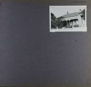
Album - Album page, Meadow Street, Circa 1972
This photograph is part of the Caulfield Historical Album 1972. This album was created in approximately 1972 as part of a project by the Caulfield Historical Society to assist in identifying buildings worthy of preservation. The album is related to a Survey the Caulfield Historical Society developed in collaboration with the National Trust of Australia (Victoria) and Caulfield City Council to identify historic buildings within the City of Caulfield that warranted the protection of a National Trust Classification. Principal photographer thought to be Trevor Hart, member of Caulfield Historical Society. Most photographs were taken between 1966-1972 with a small number of photographs being older and from unknown sources. All photographs are black and white except where stated, with 386 photographs over 198 pages. Page 134 of Photograph Album with one landscape photograph of a Victorian house on Meadow Street.Handwritten: Meadow Street [top right] / 134 [bottom right]trevor hart, east st kilda, decorative brackets, picket fence, slate roof, chimneys, garden, cast iron columns, cast iron frieze, meadow street, st kilda east, caulfield, victorian style, cast iron work, verandahs -
 Glen Eira Historical Society
Album - Album page, 31 Nepean Highway, Circa 1972
... style polychrome bricks william millar slate roofs brick houses ...This photograph is part of the Caulfield Historical Album 1972. This album was created in approximately 1972 as part of a project by the Caulfield Historical Society to assist in identifying buildings worthy of preservation. The album is related to a Survey the Caulfield Historical Society developed in collaboration with the National Trust of Australia (Victoria) and Caulfield City Council to identify historic buildings within the City of Caulfield that warranted the protection of a National Trust Classification. Principal photographer thought to be Trevor Hart, member of Caulfield Historical Society. Most photographs were taken between 1966-1972 with a small number of photographs being older and from unknown sources. All photographs are black and white except where stated, with 386 photographs over 198 pages. Victorian Heritage Database - HO48 - 31 Nepean Highway Elsternwick https://vhd.heritagecouncil.vic.gov.au/places/35531 (at 15/08/2021) "Roseneath" at 31 Point Nepean Road is a bi-chromatic Italianate villa built for William Millar in 1874. It is aesthetically and historically important. "Roseneath's aesthetic value derives from its survival as a substantially intact bi-chromatic brick villa, distinguished by the symmetrical north and south facing bays and by its spacious grounds. Its historical value rests on its comparatively early date and link with Shire councillor William Millar. The choice of bi-chromatic brick, which was highly fashionable at the time, is also of note. "Roseneath" compares with "Cumbernauld" (pre 1872) at 504 Hawthorn Road and "Glenmoore" (1870) at 1 St Georges Road.Page 140 of Photograph Album with three (landscape) photographs of Roseneath on Nepean Highway. Handwritten: 31 Nepean Highway [top right] / 140 [bottom right]trevor hart, verandah, chimneys, porch, decorative brackets, single storey, cast iron columns, return verandah, garden, nepean highway, roseneath, italianate, 1870's, elsternwick, cast iron work, victorian style, polychrome bricks, william millar, slate roofs, brick houses, house names -
 Glen Eira Historical Society
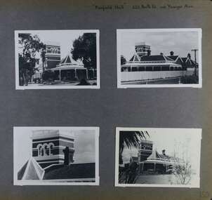
Album - Album page, Fairfield Hall, 225 North Road, Circa 1972
This photograph is part of the Caulfield Historical Album 1972. This album was created in approximately 1972 as part of a project by the Caulfield Historical Society to assist in identifying buildings worthy of preservation. The album is related to a Survey the Caulfield Historical Society developed in collaboration with the National Trust of Australia (Victoria) and Caulfield City Council to identify historic buildings within the City of Caulfield that warranted the protection of a National Trust Classification. Principal photographer thought to be Trevor Hart, member of Caulfield Historical Society. Most photographs were taken between 1966-1972 with a small number of photographs being older and from unknown sources. All photographs are black and white except where stated, with 386 photographs over 198 pages. Glen Eira Heritage Management Plan 1996 by Andrew Ward https://www.gleneira.vic.gov.au/media/4777/heritage_mment_plan_vol_3b.pdf (as of 27/01/2021) - p90 An imposing single storeyed Italianate bi-chromatic brick villa with three staged tower surmounting the entry and facetted corner bay with conical roof. White tuckpointed black body bricks are relieved with reds and stucco work. Gable ends are fretted and there is a concave cast iron verandah to the principal elevations.Victorian Heritage Database (as of 27/10/2020) - HO49 225 North Road Caulfield South https://vhd.heritagecouncil.vic.gov.au/places/42426 "Maniar" (?) is a substantial late Victorian Italianate villa with tower and extensive grounds built for Frederick Curwan, an inspector of the National Bank, in 1890. It is aesthetically and historically important. An imposing single storeyed ltalianate bi-chromatic brick villa with three staged tower surmounting the entry and facetted comer bay with conical roof. White tuckpointed black body bricks are relieved with reds and stucco work. Gable ends are fretted and there is a concave cast iron verandah to the principal elevations. It is aesthetically important as an imposing and substantially intact villa residence demonstrating the changing architectural fashions of the 1890's, evidenced by the use of face brickwork and fretted gables in the Queen Anne manner. It is historically important for the manner in which it demonstrates the lifestyle to which a businessman could aspire during the boom period.Page 150 of Photograph Album with four landscape photographs of Fairfield Hall on North Road.Handwritten: "Fairfield Hall" 225 North Rd cnr Younger Ave [top right] / 150 [bottom right]trevor hart, jenny o'donnell, verandah, porch, tower house, tower, mansion, three storey tower, bichromatic brickwork, fairfield hall, 1890's, george jobbins, conical roofed projecting corner bay, conical roofed bay, timber ceilings, north road, younger avenue, frederick wallis curwan, curwan, italianate, queen anne, australian homestead, arched windows, curved windows, columned parapet, return verandah, fairfield estate, fairfield street, slate roofed, red brick, polychrome bricks, victorian style, cast iron work, caulfield south, maniar, house names -
 Glen Eira Historical Society
Album - Album page, 84 Orrong Crescent, Circa 1972
... iron work victorian style mansions house names slate roofs ...This photograph is part of the Caulfield Historical Album 1972. This album was created in approximately 1972 as part of a project by the Caulfield Historical Society to assist in identifying buildings worthy of preservation. The album is related to a Survey the Caulfield Historical Society developed in collaboration with the National Trust of Australia (Victoria) and Caulfield City Council to identify historic buildings within the City of Caulfield that warranted the protection of a National Trust Classification. Principal photographer thought to be Trevor Hart, member of Caulfield Historical Society. Most photographs were taken between 1966-1972 with a small number of photographs being older and from unknown sources. All photographs are black and white except where stated, with 386 photographs over 198 pages. From Victorian Heritage Database citation for 84 Orrong Crescent https://vhd.heritagecouncil.vic.gov.au/places/35584 as at (28/10/2020) "St. Reliers" at 84 Orrong Crescent is important as an unusually excessively enriched asymmetrical villa residence of the Boom period. From Victorian Heritage Database citation for HO50 84 Orrong Crescent Caulfield North https://vhd.heritagecouncil.vic.gov.au/places/35584 as at (28/10/2020) An imposing Italianate two storeyed asymmetrical villa with overpainted stuccoed surfaces to the facade, distinguished by their ornate treatment. Unusually rich ornamentation includes the acanthus leaf impost capitals, aedicules with swags and volutes, foliated panels to the frieze, ashlar treatment to the lower level and quoins above. The two storeyed cast iron verandah with timber frieze rail protects a black and white tiled floor. The hipped roof has patterned slates.Page 152 of Photograph Album with two landscape photographs of Bonhurst on Orrong Crescent.Handwritten: 84 Orrong Crescent [top right] / NOW 84 - PREVIOUSLY 120 ORRONG CRESCENT / "BONHURST" [under bottom photo] / 152 [bottom right]trevor hart, verandah, porch, slate roof, garden, decorative brackets, fanlight, protruding bay, bay window, garden lamp, asymmetrical, bonhurst, st reliers, rendered, orrong crescent, caulfield north, cast iron work, victorian style, mansions, house names, slate roofs, italianate style -
 Glen Eira Historical Society
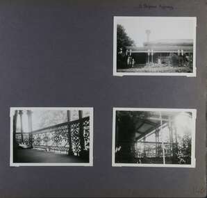
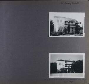
Album - Album page, Grimwade House, Orrong Road, Circa 1972
... house of its time, the classic Italian form with comer verandah ...This photograph is part of the Caulfield Historical Album 1972. This album was created in approximately 1972 as part of a project by the Caulfield Historical Society to assist in identifying buildings worthy of preservation. The album is related to a Survey the Caulfield Historical Society developed in collaboration with the National Trust of Australia (Victoria) and Caulfield City Council to identify historic buildings within the City of Caulfield that warranted the protection of a National Trust Classification. Principal photographer thought to be Trevor Hart, member of Caulfield Historical Society. Most photographs were taken between 1966-1972 with a small number of photographs being older and from unknown sources. All photographs are black and white except where stated, with 386 photographs over 198 pages. From Victorian Heritage Database citation HO54 Grimwade House, former Harleston stables, outbuilding, garden, gate and Picconia excelsa tree. https://vhd.heritagecouncil.vic.gov.au/places/35573 as at (28/10/2020) ''Harleston'', now "Grimwade House", is situated at no. 67 Balaclava Road, Caulfield North, at the Orrong Road corner. It was built for Frederick, later Sir Frederick, Grimwade, to the design of architect Thomas Watts in 1875. Today the complex has been incorporated in the Melbourne Grammar Junior School campus. It retains not only the main house but also the stables and mature garden setting with driveway and gates. It is historically, aesthetically and socially significant.From Victorian Heritage Database citation HO54 Grimwade House, former Harleston stables, outbuilding, garden, gate and Picconia excelsa tree. https://vhd.heritagecouncil.vic.gov.au/places/35573 as at (28/10/2020) It is historically significant (Criterion A) as the former home of prominent business man, speculator and benefactor, Sir Frederick Grimwade. Both Grimwade and his house are exemplars of the commercial enterprise of the Boom period and the amassing of personal fortunes with which it is associated. It is aesthetically significant (Criterion E) as an imposing yet stately large house of its time, the classic Italian form with comer verandah terminated by projecting wings being most distinctively seen in this instance. It is enhanced not only by the garden setting but also by the delicate cast iron verandah spandrels, stained glass work and stencilled ceiling in the music room. It is socially significant (Criterion G) on account of the value placed on it by the community associated with the Melbourne Grammar Junior School since its inception on this site in 1911.Page 154 of Photograph Album with five photographs (4 landscape and one portrait) including Grimwade House, gates and a tram shelter.Handwritten: Grimwade House (Melbourne Grammar Prep School) / incorporating "Harleston" Orrong Rd. S.E cnr Balaclava Rd [top right] / 154 [bottom right]trevor hart, verandah, porch, slate roof, garden, grimwade house, grimwade, harleston, sir frederick grimwade, thomas watts, orrong road, balaclava road, melbourne grammar, melbourne grammar junior school, italianate, cast iron verandah spandrels, stained glass, stencilled ceiling, mgs, m.g.s, school, grimwade family, jessie grimwade, gates, palisade style fence, cast iron spears, stone plinths, melbourne grammar prep school, victorian style, cast iron work, caulfield north, gardens, cars, tram services, outbuildings, stables, trees, picconia excelsa tree -
 Glen Eira Historical Society
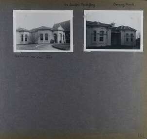
Album - Album page, St Joseph's Presbytery, Orrong Road, Circa 1972
This photograph is part of the Caulfield Historical Album 1972. This album was created in approximately 1972 as part of a project by the Caulfield Historical Society to assist in identifying buildings worthy of preservation. The album is related to a Survey the Caulfield Historical Society developed in collaboration with the National Trust of Australia (Victoria) and Caulfield City Council to identify historic buildings within the City of Caulfield that warranted the protection of a National Trust Classification. Principal photographer thought to be Trevor Hart, member of Caulfield Historical Society. Most photographs were taken between 1966-1972 with a small number of photographs being older and from unknown sources. All photographs are black and white except where stated, with 386 photographs over 198 pages. St Joseph's buildings and grounds are contributory properties to HO72 Elsternwick Estate and environs - City of Glen Eira.Page 162 - two photographs of St Joseph's Presbytery, Orrong Road.Handwritten: St Joseph's Presbytery Orrong Road [top right] / PREVIOUSLY "THE EMS" 1908 [under left photo] / 162 [bottom right]trevor hart, orrong road, curved windows, decorative brackets, arched windows, bay window, portico, slate roof, st joseph's presbytery, catholic church, st joseph's church, st joseph's primary school, porte cochere, the ems, elsternwick, rendered walls, clergy residences, drives, late victorian style, house names -
 Glen Eira Historical Society
Album - Album page, Glenmoore, St George's Road, Circa 1972
This photograph is part of the Caulfield Historical Album 1972. This album was created in approximately 1972 as part of a project by the Caulfield Historical Society to assist in identifying buildings worthy of preservation. The album is related to a Survey the Caulfield Historical Society developed in collaboration with the National Trust of Australia (Victoria) and Caulfield City Council to identify historic buildings within the City of Caulfield that warranted the protection of a National Trust Classification. Principal photographer thought to be Trevor Hart, member of Caulfield Historical Society. Most photographs were taken between 1966-1972 with a small number of photographs being older and from unknown sources. All photographs are black and white except where stated, with 386 photographs over 198 pages. From Victorian Heritage Database citation for HO59 Glenmoore, 1 St Georges Road Elsternwick https://vhd.heritagecouncil.vic.gov.au/places/35202 as at 30/10/2020 "Glenmoore" is locally significant as a surviving mid nineteenth century villa residence in the then fashionable bi-chromatic brick form. It is also important as the home of Hugh Moore who built several shops in nearby Glen Huntly Road and which remain as important contributors to the architectural character of the Elsternwick Shopping Centre.Victorian Heritage Database citation HO59 Glenmoore, 1 St Georges Road Elsternwick https://vhd.heritagecouncil.vic.gov.au/places/35202 An imposing two storeyed villa in bichrome brick with two storeyed timber posted verandah, coupled with cast iron lace frieze, spandrels and central tympanum enrichment. The hipped roof is in slate and has a prominent crean1 brick chimney stack forming part of the facade. Openings are flat arched although the entrance is round arched with a fan light. The south elevation has bayed windows. Two storeyed hip roofed additions are sympathetic and attached on the north side and at the rear. Inside, the staircase and stained glasswork with initials "HM" and family coat of arms are important surviving elements. INTEGRITY: Good, timber outbuildings of an early date, mature and spacious front garden includes early palm trees. Alterations include reconstruction of facade verandah including tiled pavement and front door on east side. Interior has a high level of integrity. Original grounds included adjoining "Carramar".Page 178 of Photograph Album with three photographs of Glenmoore, St Georges Road. Handwritten: "Glenmoore" 1 St George's Road [top right] / 178 [bottom right]trevor hart, chimneys, porch, mansion, slate roof, return verandah, stained glass, cast iron frieze, glenmoore, 1860's, hugh moore, glenmoore estate, double storey, elsternwick shops, st george's road, thomas watts, elsternwick, victorian style, protruding bay windows, cast iron work, bi-chromatic bricks, gardens, balconies, moore's buildings, glen huntly road, stairs, house names -
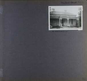 Glen Eira Historical Society
Album - Album page, Staniland Grove, Circa 1972
This album was created in approximately 1972 as part of a project by the Caulfield Historical Society to assist in identifying buildings worthy of preservation. The album is related to a Survey the Caulfield Historical Society developed in collaboration with the National Trust of Australia (Victoria) and Caulfield City Council to identify historic buildings within the City of Caulfield that warranted the protection of a National Trust Classification. Principal photographer thought to be Trevor Hart, member of Caulfield Historical Society. Most photographs were taken between 1966-1972 with a small number of photographs being older and from unknown sources. All photographs are black and white except where stated, with 386 photographs over 198 pages. 15 Staniland Grove is a contributory property to HO72 Elsternwick Estate and environs.Page 192 of Photograph Album with one photograph of a house on Staniland Grove.Handwritten: Staniland Street altered to Staniland Grove [top right] / 15 STANILAND ST [under photo] /192 [bottom right]trevor hart, chimneys, porch, villa residence, garden, verandah, 1890's, late victorian, decorative brackets, cast iron lacework, 1880's, slate roof, single storey, cast iron columns, cast iron frieze, elsternwick, boom period, triangulated pediment, coloured glass, mosaic tiling, complex tiled patterns, pots, italianate, staniland grove, rendered -
Glen Eira Historical Society
Letter - ‘MOOD KEE’
Three items about this property, two of which were provided by Peter R Murray (author of ‘From sand, swamp and heath...’. 1/A handwritten letter to P Murray from ex resident Gwen Joynes giving some history on people and places, possibly to help with his book on Caulfield’s past. Dated 08/12/1976. 2/A handwritten letter to Mr Murray from Gwen Joynes with details about accompanying photograph of ‘Moodkee’ and people in photograph; photograph presumably returned as requested. Dated 24/03/1977 3/A photocopied photo of Mood Kee and some written research from Sand Swamp and Heath. Photo likely to be that referred to above.pennington harold, caulfield council’s meeting room, harcourt avenue, caulfield town hall, ‘rosecraddock’, caulfield, davies sydney, langdon family, ‘mood kee’, fonts, ‘yerangle’, house names, st mary’s church of england, johnstone brid. gen., subdivisions, swagmen, johnstone mrs, davis sydney, r.s.l club, ‘ripley’, slaney family, ‘sylverly’, ‘belton’, davis family, glen eira, ‘garrell’, greenwood family, ‘sanquar’, kooyong road, bell family, ‘royston’, slatter family, ‘hengar’, glen eira road, langdon family, joynes gwen, davis gwen, mosley g mrs, davies mrs, mudge mrs, slate tiles, verandahs, weatherboard buildings, brick houses, bluestone, board and shire offices