Showing 68 items matching "splitting"
-
 Flagstaff Hill Maritime Museum and Village
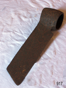
Tool - Froe, Late 19th to Early 20th century
A froe was used for splitting, or riving, wood in the early days and was a skill practiced by craftsmen who made boards, shingles, c lapboards, fences, basket splints, chair parts, wagon spokes, lath, and more. Our ancestors used axes, gluts or wedges, froes, draw knives and spelk planes for splitting wood. The froe was designed in many sizes and designs for splitting timber. It is typically an L-shaped tool made up of a wedge-shaped blade with a dull, but not blunt, knife edge and a wood handle. Blades were usually straight with a socket forged at one end for a handle, but curved blades were also made. Most handles were round and tapered and were inserted up through this socket. But some froes had eyes similar to those on axes for handles that were wedged. The froe handle is held in an upright position in one hand while the other hand drives the top of the blade downward with a wood froe club or mallet. After a split is started, the froe is wiggled downward to lengthen it until the split is complete. Most old froes were hand forged, but they were also available in many catalogues. The 1873 D.R. Barton American catalogue offered straight froes at 12 1/2 cents per inch. You can still buy new froes from many tool manufacturers today.A tool that has not changed in design or use since its inception several hundred years ago to split timber for various uses.Froe, also called cooper's froe or stave froe, without handle.Noneflagstaff hill, warrnambool, flagstaff-hill, flagstaff-hill-maritime-museum, maritime-museum, shipwreck-coast, flagstaff-hill-maritime-village, froe, cooper's froe, stave froe, wood splitter, carpenders tools, coopers tool, splitting timber -
 Flagstaff Hill Maritime Museum and Village
Spoon, circa 1878
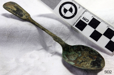
This tea spoon is from the wreck of the LOCH ARD, a Loch Line ship of 1,693 tons which sailed from Gravesend, London, on 2 March 1878 with 17 passengers and a crew of 36 under Captain George Gibbs. “The intention was to discharge cargo in Melbourne, before returning to London via the Horn with wool and wheat”. Instead, on 1 June 1878, after 90 days at sea, she struck the sandstone cliffs of Mutton Bird Island on the south west coast of Victoria, and sank with the loss of 52 lives and all her cargo. The manifest of the LOCH ARD listed an array of manufactured goods and bulk metals being exported to the Colony of Victoria, with a declared value of £53,700. (202 bills of lading show an actual invoice value of £68, 456, with insurance underwriting to £30,000 of all cargo). Included in the manifest is the item of “Tin hardware & cutlery £7,530”. This teaspoon is one of 482 similar items of electro-plated cutlery from the LOCH ARD site, comprising spoons and forks of various sizes but all sharing the same general shape or design and metallic composition. 49 of these pieces display a legible makers’ mark — the initials “W” and “P” placed within a raised diamond outline, which is in turn contained within a sunken crown shape — identifying the manufacturer as William Page & Co of Birmingham. An electroplater’s makers’ marks, unlike sterling silver hallmarks, are not consistent identifiers of quality or date and place of manufacture. A similar line of five impressions was usually made to impress the consumer with an implication of industry standards, but what each one actually signified was not regulated and so they varied according to the whim of the individual foundry. In this case, the maker’s marks are often obscured by sedimentary accretion or removed by corrosion after a century of submersion in the ocean. However sufficient detail has survived to indicate that these samples of electro-plated cutlery probably originated from the same consignment in the LOCH ARD’s cargo. The following descriptions of maker’s marks are drawn from 255 tea spoons, 125 dessert spoons, and 99 table forks. These marks are clearly visible in 66 instances, while the same sequence of general outlines, or depression shapes, is discernible in another 166 examples. 1. A recessed Crown containing a raised Diamond outline and the initials “W” and “P” (the recognised trademark of William Page & Co) 2. An impressed Ellipse containing a raised, pivoted, Triangle in its lower part and bearing a Resurrection Cross on its upper section (a possible dissenting church symbol reflecting religious affiliation); OR a rounded Square impression containing a raised, ‘lazy’, letter “B” (possibly mimicking sterling silver hallmark signifying city of manufacture i.e. Birmingham) 3. An impressed rounded Square filled with a raised Maltese Cross (the base metal composite of nickel silver was also known as ‘German silver’ after its Berlin inventors in 1823) 4. A recessed Circle containing a Crab or Scarab Beetle image; OR a recessed Circle containing a rotated ‘fleur de lys’ or ‘fasces’ design 5. A depressed Diamond shape enclosing a large raised letter “R” and a small raised letter “D” (mimicking the U.K. Patent Office stamp which abbreviated the term ‘registered’ to “RD”, but also included date and class of patent) Suggested trade names for William Page & Co’s particular blend of brass plating are ‘roman silver’ or ‘silverite’. This copper alloy polishes to a lustrous gold when new, discolouring to a murky grey with greenish hue when neglected. HISTORY OF THE LOCH ARD The LOCH ARD belonged to the famous Loch Line which sailed many ships from England to Australia. Built in Glasgow by Barclay, Curdle and Co. in 1873, the LOCH ARD was a three-masted square rigged iron sailing ship. The ship measured 262ft 7" (79.87m) in length, 38ft (11.58m) in width, 23ft (7m) in depth and had a gross tonnage of 1693 tons. The LOCH ARD's main mast measured a massive 150ft (45.7m) in height. LOCH ARD made three trips to Australia and one trip to Calcutta before its final voyage. LOCH ARD left England on March 2, 1878, under the command of Captain Gibbs, a newly married, 29 year old. She was bound for Melbourne with a crew of 37, plus 17 passengers and a load of cargo. The general cargo reflected the affluence of Melbourne at the time. On board were straw hats, umbrella, perfumes, clay pipes, pianos, clocks, confectionary, linen and candles, as well as a heavier load of railway irons, cement, lead and copper. There were items included that intended for display in the Melbourne International Exhibition in 1880. The voyage to Port Phillip was long but uneventful. At 3am on June 1, 1878, Captain Gibbs was expecting to see land and the passengers were becoming excited as they prepared to view their new homeland in the early morning. But LOCH ARD was running into a fog which greatly reduced visibility. Captain Gibbs was becoming anxious as there was no sign of land or the Cape Otway lighthouse. At 4am the fog lifted. A man aloft announced that he could see breakers. The sheer cliffs of Victoria's west coast came into view, and Captain Gibbs realised that the ship was much closer to them than expected. He ordered as much sail to be set as time would permit and then attempted to steer the vessel out to sea. On coming head on into the wind, the ship lost momentum, the sails fell limp and LOCH ARD's bow swung back. Gibbs then ordered the anchors to be released in an attempt to hold its position. The anchors sank some 50 fathoms - but did not hold. By this time LOCH ARD was among the breakers and the tall cliffs of Mutton Bird Island rose behind the ship. Just half a mile from the coast, the ship's bow was suddenly pulled around by the anchor. The captain tried to tack out to sea, but the ship struck a reef at the base of Mutton Bird Island, near Port Campbell. Waves broke over the ship and the top deck was loosened from the hull. The masts and rigging came crashing down knocking passengers and crew overboard. When a lifeboat was finally launched, it crashed into the side of LOCH ARD and capsized. Tom Pearce, who had launched the boat, managed to cling to its overturned hull and shelter beneath it. He drifted out to sea and then on the flood tide came into what is now known as LOCH ARD Gorge. He swam to shore, bruised and dazed, and found a cave in which to shelter. Some of the crew stayed below deck to shelter from the falling rigging but drowned when the ship slipped off the reef into deeper water. Eva Carmichael had raced onto deck to find out what was happening only to be confronted by towering cliffs looming above the stricken ship. In all the chaos, Captain Gibbs grabbed Eva and said, "If you are saved Eva, let my dear wife know that I died like a sailor". That was the last Eva Carmichael saw of the captain. She was swept off the ship by a huge wave. Eva saw Tom Pearce on a small rocky beach and yelled to attract his attention. He dived in and swam to the exhausted woman and dragged her to shore. He took her to the cave and broke open case of brandy which had washed up on the beach. He opened a bottle to revive the unconscious woman. A few hours later Tom scaled a cliff in search of help. He followed hoof prints and came by chance upon two men from nearby Glenample Station three and a half miles away. In a state of exhaustion, he told the men of the tragedy. Tom returned to the gorge while the two men rode back to the station to get help. By the time they reached LOCH ARD Gorge, it was cold and dark. The two shipwreck survivors were taken to Glenample Station to recover. Eva stayed at the station for six weeks before returning to Ireland, this time by steamship. In Melbourne, Tom Pearce received a hero's welcome. He was presented with the first gold medal of the Royal Humane Society of Victoria and a £1000 cheque from the Victorian Government. Concerts were performed to honour the young man's bravery and to raise money for those who lost family in the LOCH ARD disaster. Of the 54 crew members and passengers on board, only two survived: the apprentice, Tom Pearce and the young woman passenger, Eva Carmichael, who lost all of her family in the tragedy. Ten days after the LOCH ARD tragedy, salvage rights to the wreck were sold at auction for £2,120. Cargo valued at £3,000 was salvaged and placed on the beach, but most washed back into the sea when another storm developed. The wreck of LOCH ARD still lies at the base of Mutton Bird Island. Much of the cargo has now been salvaged and some was washed up into what is now known as LOCH ARD Gorge. Cargo and artefacts have also been illegally salvaged over many years before protective legislation was introduced. One of the most unlikely pieces of cargo to have survived the shipwreck was a Minton porcelain peacock - one of only nine in the world. The peacock was destined for the Melbourne International Exhibition in 1880. It had been well packed, which gave it adequate protection during the violent storm. Today, the Minton peacock can be seen at the Flagstaff Hill Maritime Museum in Warrnambool. From Australia's most dramatic shipwreck it has now become Australia's most valuable shipwreck artefact and is one of very few 'objects' on the Victorian State Heritage Register The LOCH ARD shipwreck is of State significance – Victorian Heritage Register S 417. Flagstaff Hill’s collection of artefacts from LOCH ARD is significant for being one of the largest collections of artefacts from this shipwreck in Victoria. It is significant for its association with the shipwreck, which is on the Victorian Heritage Register (VHR S417). The collection is significant because of the relationship between the objects, as together they have a high potential to interpret the story of the LOCH ARD. The LOCH ARD collection is archaeologically significant as the remains of a large international passenger and cargo ship. The LOCH ARD collection is historically significant for representing aspects of Victoria’s shipping history and its potential to interpret sub-theme 1.5 of Victoria’s Framework of Historical Themes (living with natural processes). The collection is also historically significant for its association with the LOCH ARD, which was one of the worst and best known shipwrecks in Victoria’s history. Unrestored tea spoon from the wreck of the LOCH ARD. The spoon design has a flattened fiddle-back handle, with a thin stem or shank, flared collar, and elongated bowl. The spoons metallic composition is a thin layer of brass alloy which has partially corroded back to a nickel-silver base metal. Only 15% of plate remains with 10% acqua-marine verdigris. Outlines of five makers marks are visible (Crown, Ellipse, Rounded Square, Circle, Diamond). There is splitting on the edge of the bowl.flagstaff hill, warrnambool, shipwrecked coast, flagstaff hill maritime museum, maritime museum, shipwreck coast, flagstaff hill maritime village, great ocean road, loch line, loch ard, captain gibbs, eva carmichael, tom pearce, glenample station, mutton bird island, loch ard gorge, electroplated cutlery, loch ard shipwreck, nickel silver, william page & co, birmingham, brass plating, makers marks -
 Bendigo Historical Society Inc.
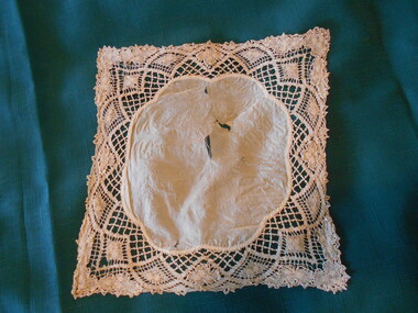
Clothing - MAGGIE BARBER COLLECTION: DARK CREAM SILK AND LACE HANDKERCHIEF, 1800's
Clothing. Deep cream silk centre piece, with scalloped edges - 18 cm x 16 cm. (Scallops 6.5 cm wide). Cream linen bobbin lace - (probably Brussells Lace) surrounds the silk-9cms deep at each corner, 3.5 cms deep at the sides. Fan shapes woven in the lace, emphasize the scalloped centrepiece. Flowers as in 11414.26 and 11414.30a and b, would suggest that this lace has been made by the same maker. Silk centrepiece is damaged, with some splitting of fabric.costume accessories, female, dark cream silk and lace handkerchief -
 Robin Boyd Foundation
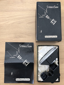
Functional object - Camera lens
Penleigh Boyd, Robin and Patricia Boyd's son, recalls that "Robin experimented with stereoscopic photography which, when viewed through either polaroid or red/green glasses, produced a three dimensional effect. A special double lens attachment with image splitting mirror was added in front of the normal camera lens to produce a double image similar to the image seen by each left and right eye". Robin experimented with stereoscopic photography when they lived in the 158 Riversdale Road Camberwell.Stereoscopic camera lens in a box with instructions in Japanese and Englishwalsh st miscellaneous, robin boyd -
 Forests Commission Retired Personnel Association (FCRPA)
Pulpwood billet hook
Pulpwood was often split by hand or with black powder splitting guns into more manageable sizes and cut into 8 foot lengths (or billets). Billets were first stacked endwise to drain the sap and lighten the load before they were loaded by hand onto flat bed trucks for transport to the mills. This long length metal hook was used to pull and manoeuvre the pulpwood billets onto the truck. The advent of excavators in logging operations in the 1970s led to the loading and carting pulpwood in long tree lengths.Long steel tool with handle on one end and hook on the other. -
 Flagstaff Hill Maritime Museum and Village
Functional object - Light Bracket, Before 1878
This pressed brass artefact is a highly decorative side bracket for distancing a gas lamp flame from the internal wall of a building. It is hollow and made of light gauge metal, with an innovative aesthetic design, but no internal piping to transport gas. It was recovered from the wreck of the LOCH ARD. There are similar artefacts in the Flagstaff Hill collection. The LOCH ARD left Gravesend (London) on 2 March 1878, bound for Melbourne, with a crew of 37, 17 passengers, and a diverse and valuable cargo of manufactured goods, luxury items, and refined metal. Some of the cargo was destined for display at Melbourne’s first International Exhibition in 1880. At 3 am, 1 June 1878, the ship was wrecked against the high limestone cliffs of Mutton Bird Island on Victoria’s south west coast near Port Campbell. Only two people survived the disaster — Tom Pearce, a male crew member, and Eva Carmichael, a female passenger. The cargo proved too difficult to salvage in the vessel’s exposed condition and was largely written off. The manifest of goods in the LOCH ARD’s holds included “Fittings gas (4 cases)”. The gas lighting of streets, public buildings, and the dwellings of wealthier private citizens was already well-advanced in the cities and major towns of the Australian colonies. In 1841 Sydney was the first to be gas-lit with 23 street lamps, 106 hotel lamps, and 200 private residences connected to the Darlinghurst “gasometer” by an underground network of metal pipes. “The dim days of oil and tallow are gone by!” pronounced one newspaper, flushed with civic pride. The 1850s Gold Rush promoted a similar attitude of confidence and affluence in the Colony of Victoria. In 1855 Melbourne was connected to its own system of subterranean gas pipes despite the same high rates of 25 shillings per 1000 cubic feet being charged, (reduced to 15 shillings in 1865 with cheaper sources of coal). By1858 Kyneton had its own gasworks to light the town (fuelled by eucalyptus leaves) and Geelong followed suit in 1860. Had the LOCH ARD reached its intended destination in 1878, it is probable that the 4 cases of brass gas light fittings on board would have found a ready market.The LOCH ARD shipwreck is of State significance — Victorian Heritage Register S417. The gas light bracket is an example of lamp fittings and plumbing from the late 19th century.A pressed brass lighting bracket recovered from the wreck of the LOCH ARD. It would be used for attaching, but simultaneously offsetting, a gas nozzle to a wall. Highly decorative in an unusually ‘modern’ or ‘art-deco’ style, with sweeping curves dissected by angular geometric pattern, and supporting a short, vertical bar with a gas nozzle on top. It is constructed of light gauge metal, with splitting along seams, and some delicate tracery is missing. Outer surface has been polished, removing sediment, but greenish oxidation remains in dents and joins. warrnambool, shipwreck coast, flagstaff hill, shipwrecked coast, flagstaff hill maritime village, flagstaff hill maritime museum, shipwreck artefact, maritime museum, gas lamps, gas lighting, gas works, brass fittings, gas pipes, loch ard, 1878 shipwreck, victorian affluence, colonial gas lighting -
 Melbourne Tram Museum
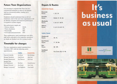
Pamphlet, Public Transport Corporation (PTC), "It's business as usual", 10/1997
Pamphlet titled "It's business as usual" issued to staff at the time of the splitting of Met Tram into two business units operating within the PTC, on 1-10-1997. This action formed Yarra Trams and Swanston Trams, later M>Tram when privatised. Provides a tram network map, depots and the routes they would be operating and names of Managing Directors and senior staff. Has a note on the future tram organisations, timetable for change and nominates the key performance targets. Provides the two logos that the companies commenced with.Yields information about the split of Met Tram into Yarra and Swanston Trams and the management of the two operators.Document - 3 fold A5 printed on gloss paper.yarra trams, swanston trams, ptc, managers, notices to staff -
 Bendigo Historical Society Inc.
Clothing - MAGGIE BARBER COLLECTION: FINE LINEN PETTICOAT- LACE TRIMMED
Clothing. Extremely fine linen petticoat, rounded neckline with a blue satin ribbon insertion, threaded through a lace insertion. This ribbon is now badly aged and shedding and splitting. A plackett at the centre back conceals six tiny 9mm covered buttons, and machine (?) stitched button holes. The neckline is outlined with three bands of cotton lace - the first band is 4.5 cm wide, and has a 'shamrock' leaf design. The middle band is 1.5 cm wide, and has a 'twisted' design, which holds the blue ribbon insertion. The outer row is 2.5 cm wide and has a scalloped edging.costume, female, lace trimmed fine linen petticoat -
 Orbost & District Historical Society
Invitation, 1969
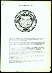
The current building was opened on Friday 28th February 1969 by the Premier of Victoria, The Hon. Sir Henry E. Bolte, K.C.M.G., M.P. The Shire of Orbost was a local government area about 380 kilometres east of Melbourne, the state capital of Victoria, Australia. The shire covered an area of 9,347 square kilometres and existed from 1892 until 1994. Originally, Orbost was part of the Bairnsdale Road District which was created on 30 April 1867. Splitting away as part of the Shire of Tambo in 1882, Orbost was first incorporated as a shire in its own right as the Shire of Croajingolong on 30 May 1892. It received its present name on 17 February 1893. On 3 January 1913 part of its western riding was annexed to Tambo as its Cunninghame Riding. Local governments play an important role in the lives of citizens in Australia. Local government authorities exist to provide services and amenities to local communities, and are also responsible for regulating and providing services for land and property in their district. This item is representative of a time when Orbost had its own Shire Council. A stapled program and invitation to the official opening of the new Orbost Shire Council Municipal Offices. A light blue card with the Orbost Shire Council insignia and gold print on front. The invitation is addressed to the secretary of Orbost Historical Society Judith Walcott.handwritten in blue pen - "Judith G Walcott"orbost-shire-council -
 Orbost & District Historical Society
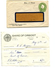
envelope and receipt, Snowy River Mail as "Mail" Print, May 17 1956
This receipt was issued to R. C. Morgan of Orbost. on May 17, 1956. It was for rent of reserve for six shillings. It was issued by the Orbost Shire Council. The Shire of Orbost was a local government area about 380 kilometres east of Melbourne, the state capital of Victoria, Australia. The shire covered an area of 9,347 square kilometres and existed from 1892 until 1994. Originally, Orbost was part of the Bairnsdale Road District which was created on 30 April 1867. Splitting away as part of the Shire of Tambo in 1882, Orbost was first incorporated as a shire in its own right as the Shire of Croajingolong on 30 May 1892. It received its present name on 17 February 1893. On 3 January 1913 part of its western riding was annexed to Tambo as its Cunninghame Riding. Local governments play an important role in the lives of citizens in Australia. Local government authorities exist to provide services and amenities to local communities, and are also responsible for regulating and providing services for land and property in their district. This item is representative of a time when Orbost had its own Shire Council. A widow - faced envelope with a green threepence stamp top right corner. At the top is "Shire of Orbost". Bottom right is "If not claimed within 7 Days please return to SHIRE HALL, ORBOST".There is a receipt to R.C. Morgan for 6/- being for the "rent of reserve" and signed by L.A. Walker. It has the Orbost Shire logo in the top left corner.orbost-shire-council morgan-r.c. -
 Orbost & District Historical Society
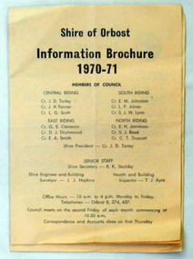
brochures, Snowy River Mail as "Mail" Print, Shire of Orbost Information Brochure, December 1970
The Shire of Orbost was a local government area about 380 kilometres east of Melbourne, the state capital of Victoria, Australia. The shire covered an area of 9,347 square kilometres ), and existed from 1892 until 1994. Originally, Orbost was part of the Bairnsdale Road District which was created on 30 April 1867. Splitting away as part of the Shire of Tambo in 1882, Orbost was first incorporated as a shire in its own right as the Shire of Croajingolong on 30 May 1892. It received its present name on 17 February 1893. On 3 January 1913 part of its western riding was annexed to Tambo as its Cunninghame Riding. On 2 December 1994, the Shire was abolished, and merged with City and Shire of Bairnsdale, Shire of Tambo, most of Shire of Omeo and the Boole Boole Peninsula from Shire of Rosedale into the Shire of East Gippsland This is a useful research tool.Two copies of a triple fold paper brochure. It is titled"Shire of Orbost Information Brochure" in black print. It contains the names of councillors, staff, the work program and budget.shire-of-orbost -
 Orbost & District Historical Society
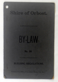
booklet, Snowy River Mail, Shire of Orbost By Laws No 28, 1920's
This booklet contains by law No 28 pertaining to building regulations. The Shire of Orbost was a local government area about 380 kilometres east of Melbourne, the state capital of Victoria, Australia. The shire covered an area of 9,347 square kilometres ), and existed from 1892 until 1994. Originally, Orbost was part of the Bairnsdale Road District which was created on 30 April 1867. Splitting away as part of the Shire of Tambo in 1882, Orbost was first incorporated as a shire in its own right as the Shire of Croajingolong on 30 May 1892. It received its present name on 17 February 1893. On 3 January 1913 part of its western riding was annexed to Tambo as its Cunninghame Riding. On 2 December 1994, the Shire was abolished, and merged with City and Shire of Bairnsdale, Shire of Tambo, most of Shire of Omeo and the Boole Boole Peninsula from Shire of Rosedale into the Shire of East Gippsland. This item is a useful research tool.A dark grey, stapled, paper covered booklet with title "Shire of Orbost By Law No 28" in black print. -
 Orbost & District Historical Society
information sheet, Welcome to the Shire of Orbost, 1992
This was possibly produced for an open day in the centenary year. The Shire of Orbost was a local government area about 380 kilometres east of Melbourne. The shire covered an area of 9,347 square kilometres and existed from 1892 until 1994. Originally, Orbost was part of the Bairnsdale Road District which was created on 30 April 1867. Splitting away as part of the Shire of Tambo in 1882, Orbost was first incorporated as a shire in its own right as the Shire of Croajingolong on 30 May 1892. It received its present name on 17 February 1893. On 3 January 1913 part of its western riding was annexed to Tambo as its Cunninghame Riding. On 2 December 1994, the Shire was abolished, and merged with City and Shire of Bairnsdale, Shire of Tambo, most of the Shire of Omeo and the Boole Boole Peninsula from Shire of Rosedale into the Shire of East Gippsland. This is a useful reference tool.Two stapled pages of printed information. On the front page is the logo of Orbost Shire Council. There is information on the role of the Shire Councillors for 1992/93. It has a map of the council building.orbost-shire-council -
 Orbost & District Historical Society
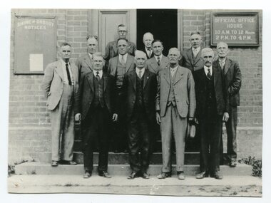
black / white photograph, first half 20th century
This is a photograph of some of the Orbost Shire councillors standing outside their council chambers. This photograph was taken before 1969 outside the previous council offices in Orbost. The current building was opened on Friday 28th February 1969 by the Premier of Victoria, The Hon. Sir Henry E. Bolte, K.C.M.G., M.P. The Shire of Orbost was a local government area about 380 kilometres east of Melbourne, the state capital of Victoria, Australia. The shire covered an area of 9,347 square kilometres and existed from 1892 until 1994. Originally, Orbost was part of the Bairnsdale Road District which was created on 30 April 1867. Splitting away as part of the Shire of Tambo in 1882, Orbost was first incorporated as a shire in its own right as the Shire of Croajingolong on 30 May 1892. It received its present name on 17 February 1893. On 3 January 1913 part of its western riding was annexed to Tambo as its Cunninghame Riding. Local governments play an important role in the lives of citizens in Australia. Local government authorities exist to provide services and amenities to local communities, and are also responsible for regulating and providing services for land and property in their district. This item is representative of a time when Orbost had its own Shire Council. A black / white photograph of a group of men standing in front of an open door of a brick building. On the left of the building is a Shire of Orbost notice board and on the right wall is a notice of the office opening hours - 10AM - 12 NOON 2PM - 4PMorbost-shire-council local government -
 Orbost & District Historical Society
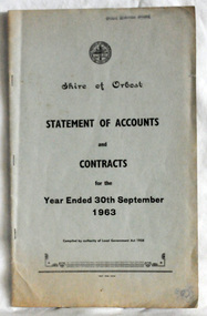
statement of accounts, Shire of Orbost Statement of Accounts, 1963
This document was made by the Shire of Orbost, local government. The Shire of Orbost was a local government area about 380 kilometres (236 mi) east of Melbourne, the state capital of Victoria, Australia. The shire covered an area of 9,347 square kilometres (3,608.9 sq mi), and existed from 1892 until 1994. Originally, Orbost was part of the Bairnsdale Road District which was created on 30 April 1867. Splitting away as part of the Shire of Tambo in 1882, Orbost was first incorporated as a shire in its own right as the Shire of Croajingolong on 30 May 1892. It received its present name on 17 February 1893. On 3 January 1913 part of its western riding was annexed to Tambo as its Cunninghame Riding. On 2 December 1994, the Shire was abolished, and merged with City and Shire of Bairnsdale, Shire of Tambo, most of Shire of Omeo and the Boole Boole Peninsula from Shire of Rosedale into the Shire of East Gippsland. Local governments play an important role in the lives of citizens in Australia. Local government authorities exist to provide services and amenities to local communities, and are also responsible for regulating and providing services for land and property in their district. This item is representative of a time when Orbost had its own Shire Council. A document with a light blue cover, black print. It is a "statement of accounts for the Shire of Orbost for the year ended 30th September, 1963".document-statement-of-accounts orbost-shire -
 Orbost & District Historical Society
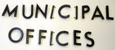
metal letters, Before 1969
These letters are from the Shire Office prior to its amalgamation to East Gippsland. They were located directly above the front doors at the front entrance to the building. The Shire coat of arms was on the wall on the right of the front entrance to the building directly above the front doors. The current building was opened on Friday 28th February 1969 by the Premier of Victoria, The Hon. Sir Henry E. Bolte, K.C.M.G., M.P. Originally, Orbost was part of the Bairnsdale Road District which was created on 30 April 1867. Splitting away as part of the Shire of Tambo in 1882, Orbost was first incorporated as a shire in its own right as the Shire of Croajingolong on 30 May 1892. It received its present name on 17 February 1893. On 3 January 1913 part of its western riding was annexed to Tambo as its Cunninghame Riding. On 2 December 1994, the Shire was abolished, and merged with City and Shire of Bairnsdale, Shire of Tambo, most of Shire of Omeo and the Boole Boole Peninsula from Shire of Rosedale into the Shire of East Gippsland. Sixteen metal letters - M U N I C I P A L O F F I C E S They are probably painted aluminium.municipal orbost-shire-council government -
 Orbost & District Historical Society
program, 1936
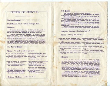
This service was held on January 28, 1936 at the Mechanics' Institute, Orbost. Born in 1865, George V was the second eldest son of Edward VII and Alexandra 1865. He first visited Australia with his elder brother Prince Albert as midshipmen aboard the HMS Bacchante in 1880. He was King of the United Kingdom and the British Dominions, and Emperor of India, from 6 May 1910 until his death in 1936. The Shire of Orbost was a local government area about 380 kilometres east of Melbourne. The shire covered an area of 9,347 square kilometres and existed from 1892 until 1994. Originally, Orbost was part of the Bairnsdale Road District which was created on 30 April 1867. Splitting away as part of the Shire of Tambo in 1882, Orbost was first incorporated as a shire in its own right as the Shire of Croajingolong on 30 May 1892. It received its present name on 17 February 1893. On 3 January 1913 part of its western riding was annexed to Tambo as its Cunninghame Riding. On 2 December 1994, the Shire was abolished, and merged with City and Shire of Bairnsdale, Shire of Tambo, most of the Shire of Omeo and the Boole Boole Peninsula from Shire of Rosedale into the Shire of East Gippsland.This item reflects the significance of monarchy for Australia and the constitutional history of Australia.The item reflects the interest in the royal family to Australians at this time as well as the general feeling of respect and admiration felt by the rural communities towards the British Royal Family..A folding single sheet, white paper program with a dark purple print. It is a program for the Orbost Shire Council memorial service for the death of King George V. On the front is "Shire of Orbost Memorial Service for his late Majesty King George V". Details of the time and venue are below. This print is inside a rectangular border. On the back of the program are the words of the national anthem, Kipling's "Recessional" and a prayer. Inside is the order of the service.royalty george-v-death-memorial orbost-shire-council -
 Mission to Seafarers Victoria
Article - Digital copy, Sailors on Holiday, 9 November 1909
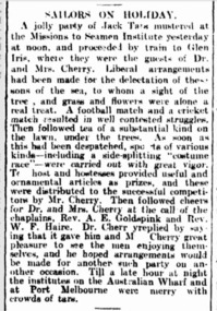
SAILORS ON HOLIDAY. . "A jolly party of Jack Tars mustered at the Missions to Seamen Institute yesterday at noon, and proceeded by train to Glen Iris, where they were the guests of Dr. and Mrs. Cherry. Liberal arrangements had been made for the delectation of these sons of the sea, to whom a sight of the tree , and grass and flowers were alone a real treat. A football match and a cricket match resulted in well contested struggles. Then followed tea of a substantial kind on the lawn, under the trees. As soon as this had been despatched, sports of various kinds— including a side-splitting "costume race"— were carried out with great vigor. The host and hostesses provided useful and ornamental articles as prizes, and these were distributed to the successful competi tors by Mr. Cherry. Then followed cheers for Dr. and Mrs. Cherry at the call of tire chaplains, Rev. A. E. Goldspink and Rev. W. F. Haire. Dr. Cherry replied by say ing that it gave him and M Cherry great pleasure to see the men enjoying them selves, and he hoped arrangements would be made for another such party ou an other occasion. Till a late hour at night the institutes on the Australian Wharf and at Port Melbourne were merry with crowds of tars."The article shows the importance of these outdoor outings for sailors after spending several months at sea.sailors, seamen, lhlg, picnics, sports, dr cherry, glen iris, thomas cherry -
 Melbourne Tram Museum
Newsletter, Rail Tram & Bus Union (RTBU), "Secretary's Newsletter 1st February 2007" & Nov. 2007, Feb. 2007
Newsletter - printed - printed full colour gloss paper A3 sheet folded to A4, titled "Secretary's Newsletter 1st February 2007", issued by the Tram and Bus division of the RTBU. Has a photo of Lou Di Gregorio. Story of Union presentations for members with 30 years of service or more, Enterprise Bargaining Agreements (EBA), sick leave, heat stress policy, splitting of annual leave, defective trams, national day of Protest and notes from the website. Includes an Advertisement from the Austral Credit Union, formerly Melbourne Credit Union. Has contact details. November 2007 issue 3 - State and Federal elections, re-tendering of the tram system franchise, Heat stress policy, PLD (Paid leave days) and distance between trams - number of incidents - photo of trams 2080 and 134. includes a photo of Bill Shorten Maribyrnong candidate visiting Essendon Depot Has photos of Lou Di Gregorio, Des Davies, Phil Altieri, Doug Brady, Ray Cooke, Ray Phillips, Greg Rogers.trams, tramways, rtbu, unions, yarra trams, presentations -
 Orbost & District Historical Society
menu, 1912
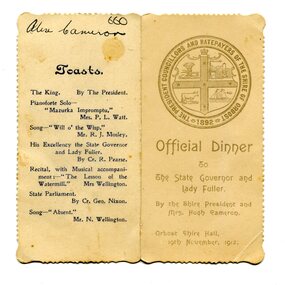
This item is an invitation to a dinner given by the Shire President and Mrs Hugh Cameron for the State Governor and Lady Fuller to be held in the Orbost Shire Hall on November 19, 1912. The governor and his wife left Melbourne on November 14 on a visit to East Gippsland. Hugh Cameron (1850-1921) was on the Orbost Shire council from 1892-1915. (more info. in O.D.H.S. newsletter -Tambo Shire) The Shire of Orbost was a local government area about 380 kilometres east of Melbourne, the state capital of Victoria, Australia. The shire covered an area of 9,347 square kilometres (3,608.9 sq mi), and existed from 1892 until 1994. Originally, Orbost was part of the Bairnsdale Road District which was created on 30 April 1867. Splitting away as part of the Shire of Tambo in 1882, Orbost was first incorporated as a shire in its own right as the Shire of Croajingolong on 30 May 1892. It received its present name on 17 February 1893. On 3 January 1913 part of its western riding was annexed to Tambo as its Cunninghame Riding. On 2 December 1994, the Shire was abolished, and merged with City and Shire of Bairnsdale, Shire of Tambo, most of Shire of Omeo and the Boole Boole Peninsula from Shire of Rosedale into the Shire of East Gippsland. This item is associated with Orbost Shire Council which no longer exists. It is also associated with Hugh Cameron.A small menu on a cream folded card with blue print. On the front is stamped a large blue logo of the Shire of Orbost. The text is "Official Dinner". On the back is a list of toasts and inside is the menu.On back - handwritten - "Alex Cameron"orbost-shire-council cameron-hugh -
 Orbost & District Historical Society
black and white photograph, late 19th century - early 20th century
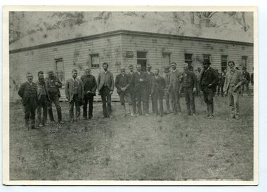
Probably taken 1890's before Orbost was separated from Tambo. The Shire of Tambo was a local government area about 320 kilometres east of Melbourne. The shire covered an area of 3,506.86 square kilometres and existed from 1882 until 1994. Tambo was first incorporated as a shire on 6 January 1882, splitting away from the Shire of Bairnsdale. On 30 May 1892 it lost three-quarters of its land area when the Shire of Orbost was incorporated. A small amount was re-annexed as Cunninghame Riding on 3 January 1913. On 2 December 1994, the Shire was abolished, and merged with the City and Shire of Bairnsdale, Shire of Orbost, most of the Shire of Omeo and the Boole Boole Peninsula from Shire of Rosedale into the Shire of East Gippsland. ( more information Newsletter July 2010). This photograph is of Tambo Shire Council meeting at Faithful's Hotel, Nowa Nowa. It includes Snowy River Riding councillors. Mary Stirling, wife of Shire Secretary Thomas Telfer Stirling, took over the Nowa Nowa Hotel from Moses Faithful in 1895. Photograph includes: John Butter BESLEY, John William BORLAND, Charles Begg IRVINE, William J. LAMBOURN, James LARKIN, Ronald McDOUGALL, Donald McRAE, William ROADKNIGHT jnr., David WILLIAMS, James CAMERON, Charles Henry GROVE. (info. John Phillips) This item is associated with the Tambo Shire Council, a local government which no longer exists.A black / white photograph of a group of men standing in a line outside a large timber building.on back - "Tambo Shire Council . Meeting at Nowa Nowa - Stirling's Hotel"tambo-shire-council faithful's-hotel-nowa-nowa local-government -
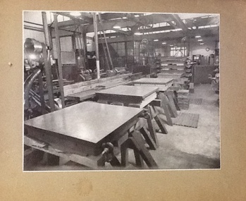 NMIT (Northern Melbourne Institute of TAFE)
Photographs - CTS 1940-1943, Collingwood Technical School. Defence Training Scheme, 1940-1943
Collingwood Technical School trained apprentices in many trades. CTS was also invlved in Training Schemes during the late 1930s and during World War II. These photographs depict some of the machines and machine parts built in class. These are high quality professional photographs taken circa 1940-1943. At this time , CTS was part of the Defence Training scheme. These photographs are a visual record of this scheme.6 black and white photographs mounted on brown card. Photographs depict various aspects of lathe work undertaken during the Defence Training Scheme, 1940-43. Also a smaller photograph of a Moultar Thread Milling Machine 1941.Each photograph has a hand written caption on the back. Captions: 1. Finished surface plates for R.A.A.F. / standing on trestle after scraping. Stack of / others in background waiting for scraping. 2. Lathe bodies in foreground, with machined / parts of lathes in middle distance, and milling / cutters, gauges and bearings in background. 3. Frames of glass splitting machines, thread / rectifying machines, and two types of milling / machine vises made in technical schools. 4.View of engineering machine shop. Carbon dioxide / freezing box in foreground, and stack of / surface plates for RAAF in middle / distance. 5.Fan geared lathes, 6 inch centres, with / self-contained motor drives, made for / cartridge factory. To be used for making / this 6.Freezing of cast iron surface plates / in layers of solid carbon dioxide / blocks. Smaller photograph has a handwritten note on the reverse: 'this photograph shows how, with the aid of a 3ft. extension mounted in front of the tool box, on which Mr. Grubb sen. is seated, these large milling machine bases ... machinists at Collingwood Technical School. A Strang, Principal 21.4.1941'. collingwood technical school, cts, apprentices, students, defence training scheme, lathes, machinery, machine parts, nmit, -
 Melbourne Legacy
Film, Firewood
15 min black and white 16 mm film, no sound. Begins with shots of trees in the bush and piles of cut logs beside a track before moving to a group of men standing by a car with 'Operation Firewood' on the boot. A road sign indicates 'Nathalia 6 1/2', 'Numurkah 22', 'Picola 3'. 'Katunga' and 'Barmah'. Shots of an empty Austin flat bed truck with 'Legacy Operation Firewood', poster on the drivers door covering the truck company name,and other empty flat bed trucks parked along a country town street which looks unsealed. A shot of a wooden sign saying 'Euroa Please slow down' follows with the Legacy car travelling very slowly past it before we see a large group of men throwing up logs onto a nearly fully loaded truck, and then a partially loaded truck with men on the flat bed stacking the logs. Five trucks are shown fully loaded and a crowd of men are gathered around a table. A circular saw (with no safety guards!) is being used to cut the bigger logs into a manageable size for splitting before being loaded by a lot of men of varying ages. The film then moves to the city where we see three men riding on the back of a moving fully loaded truck, before it stops to deliver the cut but unsplit logs to a delighted widow and her children. The logs are hurled into her front garden as a well dressed man photographs the proceedings. Other deliveries follow to further widows, but it is not clear who is going to split the logs, some of which are extremely large. The film ends showing a line of empty trucks, and a fenced city area with a sign saying 'Melbourne Legacy Firewood' holding further a supply of logs. 15 mins 07 sec. Legatees delivered firewood annually until 1995 to widows to help them through the winters in a project called 'Operation Firewood' . See also Cat. No. 000848.A record of Legacy helping widows with supplying and stacking firewood. When open fires were the main source of heating a load of firewood, and help moving it, would have been very important to the widows.Metal Kodak film cannister, silver coloured, with 'Firewood' label on outer casing.No inscriptions on internal film. operation firewood, widows -
 Box Hill Historical Society
Photograph - P Bird's timber merchant
P Bird's timber merchant brick premises established 1918 and original building with staff lined on the street.Sepia photo mounted on cardboardHandwritten family history of original donor "Ruby Sweetland daughter of Frederick & Emma Sweetland Hay N.S.W./ granddaughter James & Mary Ann Adelaide Collier, Box Hill./ now wife of Alexander Thomas Gunn of Hepburn Springs Vic 1976/Mary Ann Adelaide Collier nee Britnell, was born on way out/to Australia in the St. Vincent Gulf in a sailing boat near Adelaide/ Sth Australia, hence the name of Adelaide/ Alexander Thomas Gunn's grandfather owned the No 1 Country Hotel Licence at Kangaroo Flat "The Glasgow Arms/Hotel. near Bendigo Victoria, about 1840./ They had a family of 6 boys & 5 girls/4 boys Tom, Dan, Jack & Alexander took up land in Thorpedale/ Victoria about 1860 & paid 1 [pound] an acre for it. This land was covered/ in dense forest fern tree & fern gullies & would rain for 6 months/ in this district was the tallest tree in the world height 365 feet./ Palling splitting was main source of living for many years after being/ cleared now produces the best potatoes in Victoria. Very pretty hilly country"bird's timber yard, businesses, bird> p., timber yards, timber merchants, employees -
NMIT (Northern Melbourne Institute of TAFE)
Video recordings: Instructional NMCOT and NMIT 1980s
U-Matic Video recordings (Master tapes) mostly dated in the 1980s. Alphabetically: A house of all trades [No date] (14 min). An Introduction to floor managing An introduction to floor managing. Architrave: running the mould. Solid plastering. [No date] (17 min). Boom spray calibration (turf management). [No date] (6 min). Drafting. Module C51 Step no 4.(footwear) (1987) [No time] (Edit master) Fibrous plastering (1988) (Duration 11.00) Firm foundations: presenting a case for finance (21 min) Flux cored arc welding. Roof plumbing: fitting outlet. Friction in engineering (20 min). Grafting and budding techniques. (1986) (Duration 10.00) Horticultural courses at Collingwood College of TAFE. [No date] (10 min). Making a hand made thread. [No date] [No time] Making a hand-made thread Manual metal arc welding [No date] (24 min). Master saddlery; stitching: 1 saddle, 2 back. Microphones and their use in location sound recording [No date] [No time] Microphones and their uses in location sound recording Mold cutting [No date] [No time] Plain sailing: a film about business planning (20 min). Potentiometers, Part 1. (1983)(16 min). Preparation of artwork for video tape production (1977)(162 min). Preparation of instructional video tapes (1977)(12 min). Roof plumbing: fixing eaves cutters: Part 1 – fixing methods. [no time] Saddlery: hand stitching Safe saddle making. (1985) [No time] Solid plastering/Setting in Plaster and lime (1987) (Duration 10.00) (Edit master) Special electronic effects in video production. [No date] [No time] Splitting a stone using plugs and feathers [No date, possibly 1987] (Duration 9.40) (Master edit) The necessary art; videotape lighting: practical tips. (1974)(15 min). Tiling a staircase (1987) (Duration 25.00) (master edit) Water resistant board (W.R. Board): What is a word processor (26 min). WR Board northern metropolitan college of tafe, handbooks, nmit -
 Brighton Historical Society
Clothing - Dress, Day dress, circa 1870
The donor and family of this gown were long-term Brighton residents, and the gowns were held by them as family heirlooms prior to donation to Brighton Historical Society. Originally owned by Elizabeth Emma Adams and Cecilia Elizabeth Adams, it is believed that the dress was brought to Australia by either a half brother, James Smith Adams, or a younger sister, Sophia Charlotte Louisa Adams (later known as Mother Rose Columba Adams). Elizabeth and Cecilia were the daughters of James Smith Adams (a squire, 1780-1860) and Elizabeth Emma McTaggart (1793-1843) of Tower House, Woodchester in Gloucester, a property which Elizabeth later inherited. Originally a monastery, Tower House had been converted into a stately home after the Reformation. According to information originally provided by the donor, both this dress and the dress T0004.3 were made for Elizabeth and Cecilia, to be worn at the young Queen Victoria’s first 'drawing room ball' following the end of court mourning in 1838 for her uncle William IV who died in 1837. In 1838 Cecilia would have been twelve years old and Elizabeth would have been ten years old. It is possible that the dress T0004.3 was worn by one of the girls to this event as it is of appropriate dimensions for a child of that age, although its design is very formal and adult. However, it is unlikely that either of the girls wore this dress at the ball due to the size and styling of the dress. It is likely that the dress belonged to one of the girls, but was worn at a later date. Elizabeth was born on 30 June 1828 at Tower House and died on 1 May 1909. She created a scandal when she eloped with her first husband, Thomas Charles Gardiner at the age of 18. The validity of the marriage was later formally investigate and, while it was confirmed as valid, a second church wedding was subsequently held. Thomas died in 1878. Elizabeth subsequently remarried Reverend R. E. Blackwell, but was widowed again by 1889. Cecilia was born on 17 December 1826 and died in 1902 a spinster recluse in England. At the inquest into Cecelia's death in 1904 it was revealed that she had clearly come from a family of means as her home was filled to the brim with highly valuable goods, many in boxes. She was buried in the family vault at Woodchester. Elizabeth and Cecilia's sister Sophia converted to Roman Catholicism in 1851 and became a nun, taking the religious name 'Rose Columba'. In 1883 Mother Rose Columba led a group of eight to Australia, answering a call for Dominican sisters to nurse the sick in Adelaide. Upon arrival, she founded St. Dominic's Priory and the Church of Perpetual Adoration in North Adelaide, using her inheritance to build the chapel. Elizabeth's second son, George Henry Somerset, who inherited the Adams family estate dropped the 'i' in Gardiner and added the maiden name of his grandmother. Therefore, the family name has now become Gardner McTaggart. These Adams family entries have been updated with information provided by Dr Herbert Gardner McTaggart, great-grandson of George Henry Somerset in April 2016. Mr McTaggart contacted the society after finding our entries online.A hand sewn white purple, pink, green, blue and yellow floral silk chiffon dress from circa 1870. The dress consists of two pieces worn together as a dress. This dress has received a great deal of mending and alteration and so it is difficult to be sure of what constitutes its original state. The following description is of its current state. The bodice has a high neck with a simple shallow band collar, an olive braid and a press stud closure. The bodice fastens down the centre front with ten hook and eyes closures and two sets of ribbon ties . The bodice has three darts providing shaping into the waistline. The bodice finishes at the waist and gently tapers towards the front creating a 'V' line. Down the centre front from the neck to the waist concealing the bodice opening is a pressed pleated ruffle of the dress fabric and a line of olive braid. The dress features pagoda sleeves finished at the hem with pressed pleated ruffle of the dress fabric, a line of olive braid and a silk fringe of 4 cm pale pink and white. The skirt part of the bodice section attaches to the front of the dress with two hooks and eyes on the left hand side of the waist. The fabric drops down to approximately the knees at the front, curving up and splitting on either side over the hip. The edge of this piece is also trimmed with a pressed pleated ruffle of the dress fabric and a line of olive braid. Just below the hip on either side is a large bow of pink, cream, purple and green taffeta. The bodice at the back is shaped with four panels into the waistline. Where it joins the bodice skirt the skirt is pleated, creating fullness. The skirt of the dress ensemble secures at the waist on the left hand side. At the front it has two pleats (that may have been repositioned during repair), and is fully gathered at the back. At the front the dress falls to the floor whilst at the back it is longer to accommodate the bustle and possibly a small train.cecilia elizabeth adams, elizabeth emma adams, 1870s fashion, tower house, woodchester, james smith adams, elizabeth emma mctaggart, mary rose columba adams, sophia charlotte louisa adams -
 Brighton Historical Society
Clothing - Dress, Afternoon dress, c.1890
This afternoon dress belonged to Clara Johnstone Miller (nee Bell, 1866-1910). Clara was the only daughter of Mr James Bell, a councillor of the Shire of Leigh (today a part of Golden Plains Shire) and owner of Woolbrook Homestead in Teesdale, near Geelong. In 1888, Clara married prominent businessman, racehorse owner, racing identity and pastoralist Septimus Miller (1854-1925). Septimus was the sixth of seven children born to Henry 'Money' Miller and Eliza Miller (nee Mattinson). 'Money' Miller was a well known financier and politician and reputedly one of Australia's wealthiest people in his time. In 1889, Clara and Septimus moved into the house 'Cantala' in Dandenong Road, Caulfield. They had one child, Gwendoline Stewart Miller, who died in 1902 at the age of thirteen of diabetes - a largely untreatable condition at the time (insulin would not be discovered until 1921). Clara died in 1910, aged only 44. Septimus subsequently married Helen (nee Henderson), with whom he had a son, Ronald (1915-1990). The Millers were buried in the Brighton General Cemetery in a large Gothic-style vault. Upon Clara's death, Septimus sent much of her clothing and Gwendoline's to her mother Mary Bell. Some of these items were passed down to two of Clara's nieces, Miss Mary Bell and Mrs Lois Lillies, who donated them to BHS around 1973.A salmon (pale orange pink) corded silk afternoon dress with orange beaded embellishments, consisting of a bodice (.1) and skirt (.2) from c.1890. The bodice features a high standing collar with triple pleated bone silk chiffon trim along the top line, under the chin. This same chiffon is also secured in two pieces gathered and secured under the collar and and at the waist adding volume over the bust line and partially obscuring the jacket closing. The chiffon is secured at the side into the main fabric of the bodice by the beaded embellishment. The pink seed beads are sewn in lines of five beads one after the other creating a diagonal design that tapers from the shoulder to the waist. The bodice is boned around the front and back and secured down the centre font by nineteen hook and eyes and additional cotton tapes. Further beading details the bottom centre front and base line of the bodice. The shoulders have been repaired with replacement fabric to match, from our records it appears that the repair work was performed in circa 1974 but no record exists of the original shoulder design and if the repair was an exact copy of the original. The repaired shoulders feature a small frill around the shoulder yoke and top of the arm. The sleeve is fitted and three quarter finishing just below the elbow. The base of the sleeve is also trimmed with the pink bead design and bone three pleat chiffon trim. The back of the bodice features shaped panels contouring the jacket neatly in at the waist and then splitting and splaying out over the fullness of the skirt. The skirt appears to have been floor or ankle length held at the waist by a wide waistband. The skirt openings have been altered from the original currently featuring two openings secured by press studs. The skirt is gathered to the waistband at front and back creating fullness. The lower part of the skirt features the same pink bead embellishment and additional beaded flowers and diagonal point edge detail.clara miller, woolbrook, septimus miller, henry 'money' miller, gwendoline miller, cantala, 1890s fashion, caulfield, brighton general cemetery -
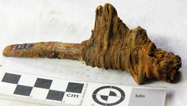 Flagstaff Hill Maritime Museum and Village
Nail, 1855
The artefact is the lower portion of a rectangular shanked ‘planking nail’ with a straight-edged ‘flat point’. The distinctive ‘point’ of a planking/skirting nail was designed to be driven into timber across the grain in order to prevent the wood from splitting. This relic is from the shipwreck of the SCHOMBERG, which ran aground near Peterborough in 1855. It was retrieved in 1875 from a large section of the ship’s bow which had been carried by ocean currents to the western coast of New Zealand’s South Island. The nail is still fixed in a fragment of the original timber that it secured in the SCHOMBERG. The top portion, or ‘head’ of the nail, has corroded away but the pronounced rectangular shank and its flat point indicate its likely purpose and position on the vessel. Most fastenings used in sailing ship construction were either wooden treenails or copper bolts, which were relatively resistant to seawater corrosion. In addition, the preferred hull-frame timber of British Oak has a high content of gallic acid which rapidly corrodes unprotected iron work. The ferrous composition of this planking nail suggests it came from an internal and upper portion of the ship’s bow (protected from exposure to the sea or oak). According to an 1855 edition of the Aberdeen Journal, the five outer layers, or ‘skins’, of the SCHOMBERG’s pine hull were “combined by means of patent screw treenails”. However the “beams of her two upper decks” were of “malleable iron”, and “part of the forecastle” was “fitted for the accommodation of the crew”. It is therefore possible that iron nails of this description were used by the ship’s builders to secure floor and wall planks in enclosed areas of the crew’s quarters. (The same reasoning would apply to officer and passenger accommodation amidships and at the stern of the vessel, but it was the bow that floated to New.Zealand.) The SCHOMBERG was a 2,000 ton clipper ship, specifically designed for the Australian immigration trade (back-loading wool for Britain’s mills), and constructed in Hall’s shipyard in Aberdeen, Scotland. She was owned by the Black Ball Line and launched in 1855. Alexander Hall & Son were renowned builders of sleek and fast 1,000 ton clippers for the China trade (opium in, tea out) and were keen to show they could also outclass the big North American ships built by Donald Mackay. Consequently the SCHOMBERG was ‘overbuilt’. Her hull featured five ‘skins’ of Scotch Larch and Pitch Pine overlaying each other in a diagonal pattern against a stout frame of British Oak. Oak has been favoured by builders of wooden ships for centuries. Its close, dense grain made it harder to work, but also gave it great strength and durability. In addition, the lateral spread of its branches supplied a natural curvature for the ribs of a vessel’s hull, as well as providing the small corner or curved pieces (‘knees’ and ‘elbows’) that fit them together. At the launch the SCHOMBERG’s 34 year old master, Captain ‘Bully’ Forbes, had promised Melbourne in 60 days, "with or without the help of God." James Nicol Forbes was born in Aberdeen in 1821 and rose to fame with his record-breaking voyages on the famous Black Ball Line ships; MARCO POLO and LIGHTNING. In 1852 in the MARCO POLO he made the record passage from London to Melbourne in 68 days. There were 53 deaths on the voyage but the great news was of the record passage by the master. In 1954 Captain Forbes took the clipper LIGHTNING to Melbourne in 76 days and back in 63 days, this was never beaten by a sailing ship. He often drove his crew and ship to breaking point to beat his own records. He cared little for the comfort of the passengers. On this, the SCHOMBERG’s maiden voyage, he was going to break records. SCHOMBERG departed Liverpool on her maiden voyage on 6 October 1855 flying the sign “Sixty Days to Melbourne”. She departed with 430 passengers and 3000 tons cargo including iron rails and equipment intended to build the Melbourne to Geelong Railway and a bridge over the Yarra from Melbourne to Hawthorn. She also carried a cow for fresh milk, pens for fowls and pigs, 90,000 gallons of water for washing and drinking. It also carried 17,000 letters and 31,800 newspapers. The ship and cargo was insured for $300,000, a fortune for the time. The winds were poor as she sailed across the equator, slowing SCHOMBERG’s journey considerably. Land was first sighted on Christmas Day, at Cape Bridgewater near Portland, and Captain Forbes followed the coastline towards Melbourne. Forbes was said to be playing cards when called by the Third Mate Henry Keen, who reported land about 3 miles off, Due in large part to the captain's regarding a card game as more important than his ship, it eventually ran aground on a sand spit near Curdie's Inlet (about 56 km west of Cape Otway) on 26 December 1855, 78 days after leaving Liverpool. The sand spit and the currents were not marked on Forbes’s map. Overnight, the crew launched a lifeboat to find a safe place to land the ship’s passengers. The scouting party returned to SCHOMBERG and advised Forbes that it was best to wait until morning because the rough seas could easily overturn the small lifeboats. The ship’s Chief Officer spotted SS QUEEN at dawn and signalled the steamer. The master of the SS QUEEN approached the stranded vessel and all of SCHOMBERG’s passengers and crew were able to disembark safely. The SCHOMBERG was lost and with her, Forbes’ reputation. The Black Ball Line’s Melbourne agent sent a steamer to retrieve the passengers’ baggage from the SCHOMBERG. Other steamers helped unload her cargo until the weather changed and prevented the salvage teams from accessing the ship. Later one plunderer found a case of Wellington boots, but alas, all were for the left foot! Local merchants Manifold & Bostock bought the wreck and cargo, but did not attempt to salvage the cargo still on board the ship. They eventually sold it on to a Melbourne businessman and two seafarers. In 1864 after two of the men drowned when they tried to reach SCHOMBERG, salvage efforts were abandoned. Parts of the SCHOMBERG were washed ashore on the south island of New Zealand in 1870, nearly 15 years after the wreck. The wreck now lies in almost 9 metres of water. Although the woodwork is mostly disintegrated the shape of the ship can still be seen due to the remaining railway irons, girders and the ship’s frame. A variety of goods and materials can be seen scattered about nearby. Flagstaff Hill holds many items salvaged from the SCHOMBERG including a ciborium (in which a diamond ring was concealed), communion set, ship fittings and equipment, personal effects, a lithograph, tickets and photograph from the SCHOMBERG. One of the SCHOMBERG bells is in the Warrnambool Library. This nail is a registered artefact from the wreck of the SCHOMBERG, Artefact Reg No S/35 and is significant because of its association with the SCHOMBERG. The SCHOMBERG collection as a whole is of historical and archaeological significance at a State level, listed on the Victorian Heritage Register VHR S612. Flagstaff Hill’s collection of artefacts from the SCHOMBERG is significant for its association with the Victorian Heritage Registered shipwreck. The collection is primarily significant because of the relationship between the objects, as together they have a high potential to interpret the story of the SCHOMBERG. The SCHOMBERG collection is archaeologically significant as the remains of an international passenger ship. The shipwreck collection is historically significant for representing aspects of Victoria’s shipping history and its potential to interpret sub-theme 1.5 of Victoria’s Framework of Historical Themes (living with natural processes). The collection is also historically significant for its association with the shipwreck and the ship, which was designed to be fastest and most luxurious of its day. The SCHOMBERG collection meets the following criteria for assessment: Criterion A: Importance to the course, or pattern, of Victoria’s cultural history. Criterion B: Possession of uncommon, rare or endangered aspects of Victoria’s cultural history. Criterion C: Potential to yield information that will contribute to an understanding of Victoria’s cultural history. The object is the bottom end of a slightly curved iron planking nail with remnant of timber still attached, recovered from the wreck of the SCHOMBERG (1855). The shank of the nail is rectangular and it narrows to a flat (chisel like) ‘point’. The ‘head’ is missing although there is a quantity of dark red corrosion within the top of the surrounding wood, suggesting where it might have been. The artefact is from the wreck of the SCHOMBERG (1855) and was retrieved from part of the ship’s bow which was carried by sea currents to the South Island of New Zealand. flagstaff hill, warrnambool, shipwrecked-coast, flagstaff-hill-maritime-museum, maritime-museum, shipwreck-coast, flagstaff-hill-maritime-village, schomberg, planking nail, rectangular ship’s nail, cast iron nail -
 Eltham District Historical Society Inc
Photograph, Tess Justine (Nillumbik Shire Council), Murray's Bridge over the Diamond Creek, Eltham North, 19 Feb 2022
Murray's Bridge over the Diamond Creek on the Diamond Creek Trail just prior to demolition and replacement with a new steel bridge. Heritage advice obtained by Nillumbik Shire Council, following a suggestion by the Eltham District Historical Society (EDHS), is that the original bridge appears to have been a simplified version of the Country Roads Board’s (CRB) standard timber bridge design of the early-to-mid 1920s. In c1990 Murray’s bridge was renovated with three recycled steel girders as part of a bike/pedestrian path in the reserve. During these alterations many parts of the bridge were removed, and some were replaced. Heritage advice indicates the condition of Murray’s bridge is poor. The remaining original parts are all in poor condition, with severe weathering, splitting and rot, especially to the stringers retained on the bridge. Heritage advice is that Murray’s Bridge does not have sufficient significance in the cultural history of the Nillumbik area to warrant inclusion in the Nillumbik Shire Heritage Overlay and also does not have sufficient significance as a rare survivor to warrant inclusion in the Nillumbik Shire Heritage Overlay. There are no indications in the historical record that this site was individually important to the cultural history of this area. EDHS is comfortable with the heritage advice provided to Council and has worked closely on this project with Council. EDHS has suggested some of the removed timbers be used in the vicinity of the bridge for landscaping and possibly seating, so as to retain these remnants close to the site of the original bridge, which is the last old timber bridge along the lower reaches of the Diamond Creek. Mary (Sweeney) Murray and John Wright Murray selected 80 acres, Lot C Section 16 and Lot 5 Section 17 Parish of Nillumbik, under an occupation license in 1866. John died in 1867 and freehold was granted to his son John in 1873. The farm was known as ‘Laurel Hill’. John Junior was an Eltham Shire councillor and sometime president from 1887 up until 1897. He added Lot A Section 16 to the farm in ca1888. John and his younger brother James arranged to rent/purchase Lot B Section 17, across Diamond Creek to the west, in ca1900. It appears that John and James farmed separately for a few years, with a new homestead built for James ad family on the high point of Lot B Section 17 in ca1910. John sold off Lot 5 Section 17 in 1912. When John died in 1912 James took over the land on both sides of the Diamond Creek. The old homestead on the west side of the Creek disappeared. A farm bridge over Diamond Creek from this period may have been located close to the northern boundary of the farm. John Langlands, owner of the farm known as ‘Ihurst’ on the west side of Diamond Creek to the south of the Murray’s land, died in 1907. In 1909 his land was then subdivided into 100 lots to become the ‘Glen Park Estate’. Other similar subdivisions of nineteenth century farms around Eltham in this period included the ‘Franktonia (or Beard’s) Estate’ to the northeast and ‘Bonsack’s Estate’ between Eltham and Greensborough. Soon after the opening of the railway extension line from Eltham to Hurstbridge in 1912, Glen Park and nearby residents including James Murray agitated for a railway station or siding to be located half-way between Eltham and Hurstbridge, so that the Glen Park residents who used the railway daily did not have to walk into the Eltham or Hurstbridge stations. Some believed Coleman’s Corner (opposite Edendale Farm) was an appropriate spot for the platform. James Murray was among those who thought the railway should be located on his land, closer to half-way between Eltham and Hurstbridge stations. The Railways Commissioners warned that the locals would have to fund these works themselves. The Glen Park Estate residents initially had difficulty accessing Eltham by road, with only an old low-level bridge over Diamond Creek at the south end of their estate. A new timber trestle bridge across the creek, now on Wattletree Road, was opened in 1915. Road access to the north was gained in 1927 when the new Murray’s Road, which crossed the Murray’s land, was built. Residents continued to agitate for a Glen Park station. By 1926 the Railways Commissioners’ preferred site was on the Murray’s land. They arranged an estimate of cost of a full-length platform. The estimate was too much for the locals, who in 1928 argued unsuccessfully for a shorter and hence cheaper platform. By 1929 Murray had agreed to donate the land, but the locals would still have to fund the works. Murray decided, unilaterally it would appear, to commence work on a timber trestle road bridge over Diamond Creek to link the new Murray Road to the proposed station. Late in 1929 he stopped work on the bridge, for reasons unknown, but started work again and completed the bridge in 1931. There is no further newspaper evidence of the campaign for the Glen Park station until 1939, when Murray and another local, Mr Maxwell, met the Railways Commissioner. The Glen Park locale now included 45 homes on the west side of the creek and 20 on the Eltham side. Most of the residents used the train every day. The Commissioner remained adamant that only a full-length platform could be built for safety reasons. It appears the campaign dissolved at this point. The increasing move to cars may have had an impact. There is no evidence of Murray’s bridge ever being connected to Murray’s Road, or of it having wide use for any purpose by locals. James Murray died in 1947 and the farm was taken over by his son James (Jim). Jim started to sell off parts of the farm in the 1980s, retaining a few acres around the ca1910 homestead and building a new house there. Recreation reserves were established along the creek. In ca1990 Murray’s bridge was renovated with steel girders as part of a bike/pedestrian path in the reserve. The old farmhouse was demolished in ca2014. * * * A theory posted on local community Facebook groups was that the bridge was built in the 1860s and was built to be more robust than was necessary for the movement of cows from one side of the creek to the other. It was suggested the robustness was necessary to support the weight of gold ore being transferred from a mine on Murray’s land to a railway siding near Murrays Bridge (presumably for transfer and processing at Diamond Creek). Perhaps this may have been one of the motivators for Murray, who really knows? Knowing when mining operations ceased on his land and how that fits the overall timeline would be useful but at the time the bridge was built, local gold production was minimal at best. The known facts are: • The railway line came to Eltham in 1902. • The extension of the railway from Eltham to Hurstbridge was constructed in 1912 so no railway line even existed through Murray's property until 1912 and the Victorian Railways maps at the time show no such siding on Murray’s property. • In 1923 a new company was formed in anticipation of the old Diamond Creek Gold Mine being re-opened. The mine had been previously closed and flooded. It was noted in the press at the time that the mine was within a mile of the railway. Nothing really came of this. • Construction of Murrays Bridge was commenced by James Murray in early 1929 in anticipation of a proposed flag station being nominated on his land, but work ceased shortly afterwards. The proposed flag station was commonly referred to as Glen Park as the residents of the Glen Park Estate wanted Option 1, located near them with the platform adjacent to Colemans corner. This was probably never going to fly as it was virtually in eyesight of Eltham station. Allandale Road was the third option, but the Commissioners' preferred option was No. 2 - on Murray's property. • The Railway Commissioners were not going to finance any such station and the works had to be funded by private landowners and residents, hence Murray investing in this himself. • Murray recommenced work two years later and finished his bridge in 1931 but unfortunately for him, the proposed flag station never eventuated. The bluestone siding you reference may well have been built by Murray as part of the proposed station platform. • Up until then, apart from the Main Road bridge, which was washed away in 1924, virtually all local crossings over the Diamond Creek were low lying bridges – Kaylocks Bridge at Brougham Street, Diamond Street bridge, Glen Park Road bridge. It is expected that Murray also had a low-lying bridge to connect his land either side of the creek. These were all washed away or severely damaged multiple times in the 1920s. Lessons were learnt, and Murrays Bridge appears to have been built in accordance with Country Road Board standards of the time. Flood damage was ongoing, and even more recently constructed raised bridges kept getting washed away, e.g., the new Wattle Tree Road bridge in 1958 just months after completion. Murray’s bridge was reinforced with steel some 30 years ago presumably to provide additional floodwater resistance, given the history of bridges disappearing in floodwaters. • In March 1932 it was reported in the Advertiser that there were still some prospectors operating around Eltham North who apart from further scarring the face of the earth over the previous two years had gained significant experience but little gold - hardly a driving factor for constructing a dedicated railway siding and bridge to transfer gold ore. It is far more probable that James Murray was hoping to have the railway station located on his property and invested his money by building the bridge to lead to it as well as a station platform. Had the station eventuated, it may well have driven up the value of his land for subdivision and new housing estates like the Glen Park Estate. That did not eventuate. Whilst the bridge was indeed old (90 years), the core structure being completed in 1931, it had been modified substantially from original and hence had no significant historic value – i.e., it was not a representative example of its type, construction, and age. Given that the bridge was not worthy of saving, the Eltham District Historical Society with Council’s support, and the Eltham Woodworkers group endeavoured to see what suitable sized timbers were salvageable to fabricate a commemorative seat. Unfortunately, the experts at the Woodworkers group were unable to salvage any suitable length/width timbers to fabricate the seat due to the presence of rot. Last remaining wooden trestle bridge on the Diamond Creek Trail just prior to demolition and replacementBorn digital image (27)diamond creek (creek), diamond creek trail, murrays bridge, ‘laurel hill’, john wright murray, mary (sweeney) murra, john murray jnr, james murray, john langlands, ‘ihurst’, ‘glen park estate’, beard's estate, franktonia, bonsack's estate, glen park estate, glen park railway station -
 The Beechworth Burke Museum
Photograph, c. 1918
Taken in c. 1918, this photograph depicts the ruins of the French village Villers-Bretonneux. In the foreground of the image are rows of shell damaged houses and buildings. In the background of the image stands a tower of the ruined church.On 24 April, Villers-Bretonneux was captured by the Germans as they advanced towards the regional city of Amiens. If they achieved their goal and drove onto the French coast, splitting the British and French armies, the Allied cause might have been lost. The fate of Amiens hung in the balance as two Australian brigades were given the task of retaking Villers-Bretonneux through a swift night-time counter attack. One brigade would assault from the south, while another would attack from the north. The assault began at 10pm on 24 April. The 13th Brigade in the south were held up by German machine guns, before the Australians linked up east of the village. After dawn on 25 April Australian and British troops were involved in fierce fighting to clear the Germans from the village. Some Germans escaped Villers-Bretonneux through nearby woods. Later on the morning of 25 April, three years to the day after the Anzacs landings at Gallipoli, French and Australian flags were raised over Villers-Bretonneux.Black and white rectangular reproduced photograph printed on matte photographic paperReverse: (A copyright and reproduction notice from the Australian War Museum, printed upside-down in blue ink) Church x Ruins/ Villers Bretonneux/ (in pencil) burke museum, world war 1, ww1, wwi, france, australia, villers-bretonneux, ruins, military album