Showing 385 items
matching subdivision map
-
 City of Kingston
Pamphlet - Colour, Ozone Hill Estate, Cheltenham, 1923
... Handwritten in blue ink on the subdivision map: 'Sold... on the subdivision map: 'Sold' is written on subdivisions 1-4, 8, 11, 13, 16 ...Sales plan for land in the suburb of Cheltenham, along both sides of Victori Avenue, off Weatherall Road.The developing urban area of Cheltenham within the City of Kingston. This land sale pamphlet illustrates the subdivision of land within the municipality and the changing demographic of the district as new houses are constructed.Colour pamphlet advertising for sale the Ozone Hill Estate, Cheltenham. Incorporates a map of the estate on either side of Victor Avenue, off Weatherall Road. Handwritten in blue ink on the subdivision map: 'Sold' is written on subdivisions 1-4, 8, 11, 13, 16-26, 28, 29, 33, 39-41 Handwritten in blue ink on the subdivision map: 'House being erected' is written on subdivisions 22 and 33. Handwrittten in grey pencil adjacent to subdivisions 21 and 22: Tennis / Courts / being / constructed / here Handwritten in grey pencil at bottom of page: Revised to 30/1/24 Handwritten in grey pencil on subdivision map: assumed land sale price is recorded on subdivisions 5-9, 9-10, 12, 14-15, 27, 30-32, 34-38. land sales, cheltenham, estate -
 City of Kingston
Pamphlet - Colour, Stillwell and Co, The Hill Estate Highett Great Subdivisional Auction Sale, 1917
... Handwritten in blue pencil on subdivision map: [tick] [on majority... sale pamphlet illustrates the subdivision of land within ...Sales plan for land in the suburb of Highett, bounded by Point Nepean Road and incorporating Sandford Street, Turner Road, Alfred Street, Peace Street and Tennyson Street. .The developing urban area of Highett within the City of Kingston. This land sale pamphlet illustrates the subdivision of land within the municipality and the changing demographic of the district as new houses are constructed.Colour pamphlet advertising subdivisional auction sale of the Hill Estate Highett. Incorporates a map of the estate bordered by Point Nepean Road and encompassing Sandford Street, Turner Road, Alfred Street, Peace Street and Tennyson St. Handwritten in grey pencil on reverse: Hill Street / Jamieson Handwritten in blue pencil on reverse: The Hill Estate Handwritten in blue pencil on subdivision map: [tick] [on majority of properties marked on map]highett, land sales, estate -
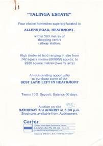 Ringwood and District Historical Society
Flyer, Land Auction Advertisement, Talinga Estate, Allens Road, Heathmont, Vic. - 1985
... Double sided A4 page with subdivision map showing location.... Double sided A4 page with subdivision map showing location ...Double sided A4 page with subdivision map showing location and size of allotments for auction on Saturday 3rd August (1985). Agent - C.E. Carter & Son Pty. Ltd., 122 Whitehorse Road, Ringwood 3134, Telephone 870 6211.Handwritten sale price annotations - Lot 1 Sold $42,000, Lot 2 Sold $42,200, Lot 3 Sold $41,500, Lot 4 Sold $53,000. -
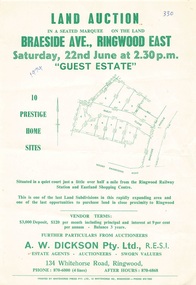 Ringwood and District Historical Society
Flyer - Land Auction, Guest Estate, Ringwood East - 1974
... include subdivision map and vendor terms. Second copy of flyer... June (1974). Details include subdivision map and vendor terms ...Two copies of single page with green print advertising auction of ten home sites on Saturday 22nd June (1974). Details include subdivision map and vendor terms. Second copy of flyer includes handwritten notation of allotment sale prices.Subdivision layout includes Mount Dandenong Road, Braeside Avenue and Guest Close, Ringwood East. Agent: A.W. Dickson, 136 Whitehorse Road, Ringwood, Phone 870-6000, after hours 870-6868. Printed by Whitehorse Press Pty. Ltd., 14 Whitehorse Road, Ringwood, Phone 870-7855. -
 Bendigo Historical Society Inc.
Map - SUTTON GRANGE, 10th July 1872
... subdivision Sutton Grange Residence sites Allotment 10 Sec. 3 Map ...Map: Residence sites at Sutton Grange, being subdivision of Allotment 10 Sec. 3, Parish of Sutton Grange (number 275 in map cupboard 1)map, subdivision, sutton grange, residence sites, allotment 10 sec. 3 -
 City of Moorabbin Historical Society (Operating the Box Cottage Museum)
Plan - Grandview Estate
... Hand drawn map of subdivision ... Grandview Estate, Bentleigh Hand drawn map of subdivision Plan ...The train line from the city to Frankston was electrified in 1922 which intensified the sale in the municipality of Moorabbin, particularly land which was in the vicinity of the railway stations.The train line from the city to Frankston was electrified in 1922 which intensified the sale in the municipality of Moorabbin, particularly land which was in the vicinity of the railway stations. The Grandview Estate was auctioned on Saturday 10 November 1922.Example of the progress of the Municipality of MoorabbinHand drawn map of subdivision Grandview Estate, Bentleighcentre road, evelyn street (now wilson street), lily street, bentleigh, realestate, auction -
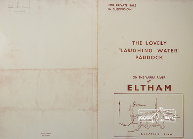 Eltham District Historical Society Inc
Photograph, For Private Sale in Subdivisions; The Lovely "Laughing Water" Paddock on the Yarra River at Eltham
... Collins Street, Melbourne Location plan and subdivision map... Collins Street, Melbourne Location plan and subdivision map ...Private sale of the "Laughing Water" paddock in subdivision; 5 river frontages with weatherboard villa on Lot 8; 6 woodland blocks of 5 and 6 acres. Sole Agent: Edward Haughton, 379 Collins Street, Melbourne Location plan and subdivision mapA3 colour photographic print from digital image of sales brochure and A4 reproduction of price listlaughing waters, edward haughton, real estate agent, eltham -
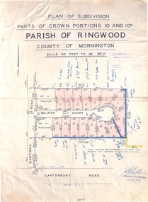 Ringwood and District Historical Society
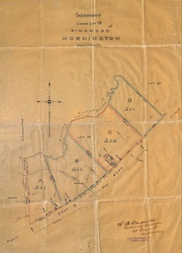
Map - Plan of Subdivision, Parts of Crown Portions 10 and 10B Parish of Ringwood - 1958
... Folded subdivision map of 15 residential allotments...Scale 80 feet to an inch. Folded subdivision map of 15 ...Folded subdivision map of 15 residential allotments in McKay Court Ringwood, off Wantirna Road north of Canterbury Road. Rubber stamped by Surveyors and Chartered Engineers J.S. Watson & Associates, Mornington and South Yarra, with illegible signature dated 17/2/58. Handwritten notations indicating allotment sale names and amounts or where passed in.Scale 80 feet to an inch. -
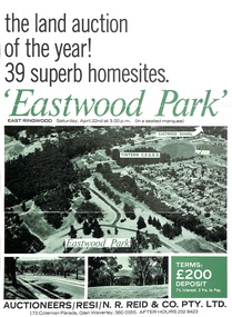 Ringwood and District Historical Society
Document - Folder, Eastwood Park Subdivision, Ringwood East, Vic. - Land Sale Circa 1967 - Site of former Eastwood/Eastfield Golf Course
... Collection of subdivision maps, and double-sided.... 5% discount for cash." Collection of subdivision maps ...Subdivision is advertised as including homesites on former Eastwood Golf Course fairways and land contours.Collection of subdivision maps, and double-sided advertisement for auction sale on Saturday, April 22nd, 1967, with summary of local features and services. Subdivision includes Croydon South streets, Andrew Crescent and Banksia Court. Agents - N.R. Reid & Co Pty Ltd, 173 Coleman Parade, Glen Waverley, Tel. 560 0355 A.H. 232 8423.Handwritten sales notations include "Vendor - Willcroft Development P/L 54-60 Southern Road Mentone Tel 93-1267 (Mrs. Morley). Lot 19 $5200, Lot 25 $4500, Lot 28 $3800, Lot 29 $3700, Lot 30 $3600. $400 deposit balance 3 yrs @ 7% $40 per month. All C/S to be prepared by vendor. 5% discount for cash." -
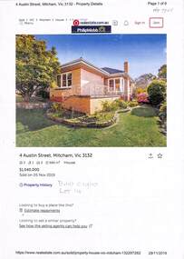 Whitehorse Historical Society Inc.
Document - Various including maps, titles, posters, Land ownership of 4 Austin Street, Mitcham, 1873 - 2019
... by Martin and Shirley Gleeson 1956 and sold in 2019. Subdivision... 1956 and sold in 2019. Subdivision map of area south of Burnett ...Ownership history of 4 Austin Street, Mitcham.Ownership history of 4 Austin Street, Mitcham between 1873 to 2019, including the plan of the Mellorton Estate, Mitcham (1923), showing some lots priced at one hundred and forty-five pounds and the Charlesworth Estate ((1913). The Austin Street house was purchased by Martin and Shirley Gleeson 1956 and sold in 2019. Subdivision map of area south of Burnett Street to Harrison Street. non-fictionOwnership history of 4 Austin Street, Mitcham.drake real estate, charlesworth estate mitcham, mellorton estate mitcham, austin street mitcham no4, ainger frank -
 City of Kingston
Pamphlet - Colour, J. F. Brady, Matthiesson's Estate, Highett, c. 1905
... the edges of the subdivision map Handwritten in grey pencil... in blue pencil: x marked on every subdivision on the map ...Sales plan for land in the suburb of Highett, bounded by Tennyson Street, James Street and Point Nepean Road and including Maher Street, Connors Street, Enright Street, Edward Street, James Street and Matthieson Street.The developing urban area of Highett within the City of Kingston. This land sale pamphlet illustrates the subdivision of land within the municipality and the changing demographic of the district as new houses are constructed close to infrastructure.Colour pamphlet advertising for private sale subdivisions in the Matthiesson's Estate, Highett. Incorporates a map of the estate bordered by Tennyson Street, James Street and Point Nepean Road and including Maher Street, Connors Street, Enright Street, Edward Street, James Street and Matthieson Street.Handwritten in blue pencil: x marked on every subdivision on the map Handwritten in grey pencil at the end of the Price List: x not sold Handwritten in grey pencil adjacent to subdivisions 58, 167 and 166: JP. Turner Handwritten in grey pencil adjacent to subdivision 164: [indecipherable] Markings in grey pencil around the edges of the subdivision map Handwritten in grey pencil on reverse: Matthiesson / Matthiesson Estate / Matthiesson Estateland sales, estate, highett -
 Ringwood and District Historical Society
Document - Folder, Byways Estate Residential Subdivision, Ringwood East, Victoria 1965-1970
... Collection of Subdivision brochures, plans, maps and sales... Collections RDHS 18023 refers.) Collection of Subdivision brochures ...Collection of Subdivision brochures, plans, maps and sales information for sectional releases of Byways Estate.Subdivision plans include: First and second release (1965-66) - Alexandra Road, Isabel Avenue, Byways Drive and Buronga Avenue. Third release (1967) - Byways Drive, Buronga Avenue, Hender Street, Lester Avenue and Jess Court. Fourth and final release (1970) - Hume Street, Walhalla Drive and Hender Street. (Agent) C.E. Carter & Son R.E.S.I. 126 Whitehorse Road, Ringwood, 3134 (Telephone) 870 2519, 870 6830, 870 6024, A.H. 723 3298, 870 4604, 870 6454. Accompanying handwritten sales notes researched in 2024 by Richard Carter - Carter Real Estate - "Vendors - Jessie May Cleland & Alan Cleland of (what became) 4 Bywats Drive. Vendors retired to Buronga near Mildura. Rex was (I think) their son. Jess Court reflects vendor's name. See also History of Byways & Coolooli by Richard Carter in RDHS archives." (Vic Collections RDHS 18023 refers.) -
 Ringwood and District Historical Society
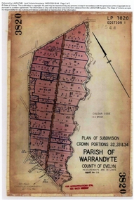
Document, Titles of land subdivision, Crown Portions 32, 33 & 34, Parish of Warrandyte, 1884 and 1907, Ringwood, Victoria
... subdivision maps and mortgage transfer pages dating from 1884 for 303... of 18 LANDATA subdivision maps and mortgage transfer pages ...Evolution of the subdivision and the use of landBlack plastic bound pockets containing copies of 18 LANDATA subdivision maps and mortgage transfer pages dating from 1884 for 303 acres 2 roods and 1 perch bounded by Warrandyte Road, Wonga Road, Oban Road and Mullum Mullum Creek in Ringwood, Victoria. Certificates of Title include Vol 1606 Fol 045 Frederick Walter Purches 1884 and subsequent transfers to 1902, and Vol 3232 Fol 646357 Ann Jane Kennedy 1907 and transfers to 1921. -
 Ringwood and District Historical Society
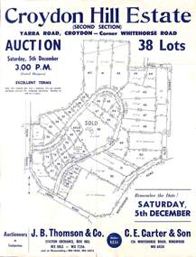
Flyer, Land Auction Sale Advertisement, Croydon Hill Estate, Croydon, Victoria - 1959
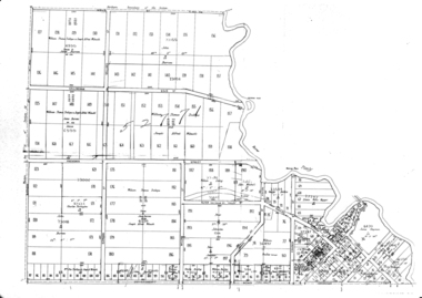
... Subdivision map includes Richardson Road, Yarra Road... Road Ringwood North melbourne Subdivision map includes ...Single sided land auction sale advertisement for 38 residential allotments - Croydon Hill Estate (Second Section) Yarra Road, Croydon - corner Whitehorse Road. Auction Saturday, 5th December, and corresponding newspaper advertisement - Ringwood Mail, Thursday, November 26, 1959.Subdivision map includes Richardson Road, Yarra Road, Whitehorse Road, Alice Street, Hull Street (later Mulawa Stret). Auctioneers in Conjunction: J.B. Thomson & Co., Station Entrance, Box Hill, (Telephone) WX 1862, WX 7356, and at Nunawading, WU 1968, WU 3452, and C.E. Carter & Son, 126 Whitehorse Road, Ringwood. WU 6024. -
 Ringwood and District Historical Society
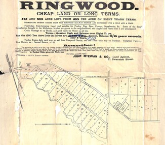
Flyer, Land Sale Advertisement, Ringwood, Victoria - 1894
... Subdivision map includes Mullum Mullum Road, Wonga Road... Road Ringwood North melbourne Subdivision map includes Mullum ...Land sale advertisement for 10 and 20 acre lots from £5 per acre on eight years' terms in Ringwood, with description of local facilities and agricultural features.Subdivision map includes Mullum Mullum Road, Wonga Road, Oban Road and Anderson's Creek Road (later Warrandyte Road). Markings on reverse side indicate the sheet was sent by post from John McEwan & Co., Auctioneers, Land Agents & Business Brokers, 71 Swanston Street, Melbourne, to Mr Allan, Builder, Ringwood, postmarked in JE (June), 1894. -
 Ringwood and District Historical Society
Document, Land Title Certificate for Henrietta Greenwood of Ringwood, Vic. - 31st January, 1931. (4 pages)
... , Victoria, including Transfers and map of subdivision..., Ringwood, Victoria, including Transfers and map of subdivision Land ...Certificate of Title - Henrietta Greenwood, Ringwood, Victoria, including Transfers and map of subdivisionIncludes transfers as part to Ernest Allan Devenish, 27th October, 1938 Lillian Alice Clegg, 10th July, 1936 Francis Leslie Little and Rose Little, 12 November, 1940 Ralph Wigley, 25 November, 1937 Alan Geoffrey Clegg, 25 November, 1937 Phillip McKinley, 8 May, 1941 John Andrew Pearson, 11 May, 1938 Paul Clegg, 8 May, 1941 The Mayor, Councillors and Burgsses of the Borough of Ringwood, 18 June, 1941 Ruby Grace Holloway, 15 October, 1941 William Herbert Holloway, 28 June, 1949 -
 Greensborough Historical Society
Map, Green's subdivision of Greensborough, 1860c
... This map shows the original subdivision of Greensborough...Copy of early map showing subdivision of Greensborough... greensborough Copy of early map showing subdivision of Greensborough ...This map shows the original subdivision of Greensborough by Edward Bernard Green. Some street names are different to today. This map shows the plan on which the town of Greensborough was based.Copy of early map showing subdivision of Greensborough. Black ink on white paper.edward bernard green, greensborough -
Whitehorse Historical Society Inc.
Map, Shire of Blackburn and Mitcham, 1928
... Combination of two sheets of detailed map. Many... Mitcham melbourne Many subdivisions shown in details with lot ...Combination of two sheets of detailed map.Combination of two sheets of detailed map. Many subdivisions shown in details with lot numbers.Combination of two sheets of detailed map. maps, shire of blackburn and mitcham -
 Ringwood and District Historical Society
Plan, Subdivision of Crown Lot 19, Ringwood, Victoria - circa 1915
... Subdivision map includes Mullum Creek, Government Road... Road Ringwood North melbourne Subdivision map includes Mullum ...Surveyor's map on wax paperSubdivision map includes Mullum Creek, Government Road to Anderson's Creek, later Warrandyte Road, Government Road to Lillydale, later Whitehorse Road, small creek bridge, later Sandy Creek at Ringwood Lake. Buildings marked include Roman Catholic Church, O.J. Pratt's House and Pratt's butcher shop (photos attached). Map by A.B. Bruford & Co., Licensed Surveyor, 47 Queen Street, Melbourne. -
 Ringwood and District Historical Society
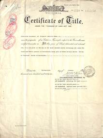
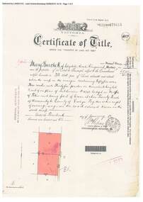
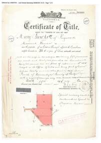
Document, Certificate of Title - Mary Burchett, Lilydale Road, Ringwood - part of Crown Section 20, Parish of Warrandyte, County of Evelyn - 14th January, 1910
... . Subdivision map includes un-named road - Grandview Grove (later.... Subdivision map includes un-named road - Grandview Grove (later ...A4 copies of Landata Victoria Historical Search documents - Vol 3398 Fol 679415.Mary Burchett of Lilydale Road, Ringwood, Married Woman, is now the proprietor of an Estate in Fee-simple subject to the Encumbrances notified hereunder ... 55 acres 3 roods 35 perches or thereabouts, being lots 8 and 9 on plan of subdivision no.4315. Subdivision map includes un-named road - Grandview Grove (later Bemboka Road, Warranwood, Vic). Title transferred to Theodore Hartley Burchett, 27th July, 1911. -
 Ringwood and District Historical Society
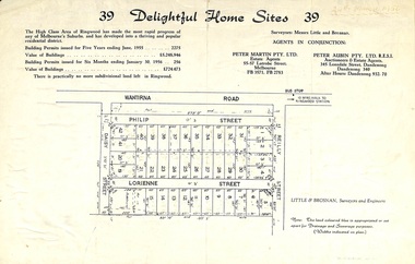
Flyer, Subdivision advertisement for sale of home sites - Ringwood, Victoria - 1956
... Subdivision map includes Reilly Street, Philip Street... Road Ringwood North melbourne Subdivision map includes Reilly ...Cardboard-backed advertisement for 39 home sites for sale, with location map, and summary of local real estate statistics in 1955 & 1956. Handwritten date noted in top right corner - 24th March, 1956.Subdivision map includes Reilly Street, Philip Street, Lorienne Street and Daisy Street in Heathmont. Surveyors: Messrs Little and Brosnan. Agents in conjunction: Peter Martin Pty. Ltd., Estate Agents, 55-57 Latrobe Street, Melbourne (Phone) FB 3571, FB 2783, and Peter Aubin Pty. Ltd., Auctioneers & Estage Agents, 345 Lonsdale Street, Dandenong (Phone) Dandenong 340, after hours Dandenong 932, 70. -
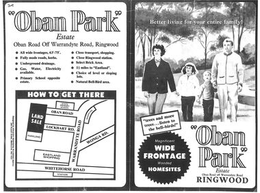 Ringwood and District Historical Society
Flyer, Land Sale Advertisement, Oban Park Estate, Ringwood, Vic. - 1969
... map, subdivision features and summary of local services...., including terms of sale, locality map, subdivision features ...One double-sided and two single-sided pages advertising Oban Park Estate land sale, including terms of sale, locality map, subdivision features and summary of local services.Subdivision includes Oban Road, Terrigal Close, Dorelaw Drive (later Melview Drive), Naroo Court, Barook Court, and Lockhart Road. Agents in Conjunction: E. Wachman, Melbourne, Hutchinson Real Estate, Ashwood, and A.W. Dickson, 136 Whitehorse Road, Ringwood (Phone) 870-6007 A.H. 882967. Separate newspaper advertisement (digital only) shows agents - Hutchison Real Estate (Telephone 277-2326) and Michelson Gelfand Pty Ltd (Telephone 53-8151). -
 Ringwood and District Historical Society
Document, Certificate of Title - Harry Temple Marshall, Wesburn Farmer, Vic. - part of Crown Section 20, Parish of Warrandyte, County of Evelyn - 1928
... with a right of carriage way over roads coloured brown. Subdivision map... with a right of carriage way over roads coloured brown. Subdivision map ...A4 copies of Landata Victoria Historical Search documents - Vol 5485 Fol 1096803. Harry Temple Marshall is now the proprietor of an Estate in Fee-simple subject to the Encumbrances notified hereunder ... 10 acres 3 roods 10 perches or thereabouts, together with a right of carriage way over roads coloured brown. Subdivision map includes un-named roads - western side is Wonga Road (later Warranwood Road), and eastern side is Grandview Grove (later Bemboka Road), both north of Plymouth Road, Ringwood, Vic. Transfers include Harold Claude Howship, 1st December, 1928 James Bell McAlpin, 26th March, 1939. -
Bendigo Historical Society Inc.
Map - DINGEE SUBDIVISION, 25/11/1913
... Map: Dingee Subdivision, Parishes of Talambe and Yallook... Map: Dingee Subdivision, Parishes of Talambe and Yallook ...Map: Dingee Subdivision, Parishes of Talambe and Yallook, County of Bendigo, Parish Plan, Canvas Backed ( number 128 in Map Cupboard 1)map, bendigo, rural, dingee subdivision, talambe, yallook, county of bendigo -
Bendigo Historical Society Inc.
Map - SUBDIVISION OF STERNBERG'S ESTATE, 24/06/1920
... Map: Subdivision of Sternberg's Estate, Crown Allotments 75... Rochester West County of Bendigo Map: Subdivision of Sternberg's ...Map: Subdivision of Sternberg's Estate, Crown Allotments 75, 76, 76A, 76B and 77, Parish of Rochester West, County of Bendigo. Parish plan Canvas backed ( number 133 in Map Cupboard 1)map, bendigo, rural, sternberg's, crown allotments 75, 76, 76a, 76b, 77, rochester west, county of bendigo -
 Ringwood and District Historical Society
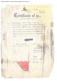
Document, Certificate of Title - Mary Burchett, Lilydale Road, Ringwood - part of Crown Section 20, Parish of Warrandyte, County of Evelyn - 5th July, 1911
... , being lots 1 and 10 on plan of subdivision no.4315. Subdivision..., being lots 1 and 10 on plan of subdivision no.4315. Subdivision ...A4 copies of Landata Victoria Historical Search documents - Vol 3520 Fol 703990.Mary Burchett of Ringwood, Married Woman, is now the proprietor of an Estate in Fee-simple subject to the Encumbrances notified hereunder ... 50 acres 1 rood 32 perches or thereabouts, being lots 1 and 10 on plan of subdivision no.4315. Subdivision map includes un-named roads - western side is Wonga Road (later Warranwood Road), and eastern side is Grandview Grove (later Bemboka Road), both north of Plymouth Road, Ringwood, Vic. Title transferred to Theodore Hartley Burchett, 27th July, 1911. Encumbrance comment "Special railway condition contained in Grant to Francis Cooke." -
Southern Sherbrooke Historical Society Inc.
Information folder - "The Bungalow"
... , description and location map./Subdivision maps, 6 sheets./Certificate..., description and location map./Subdivision maps, 6 sheets./Certificate ...Material donated by current owner, Inga Melgaard, 20th November 2006.Folder containing information pertaining to "The Bungalow", Belgrave Heights. Material supplied by current owner, Inga Melgaard, on 20th November, 2006. Contents:/"Specifications of a bungalow for W.J. Murrell's (sic) Esq" drawn up by Leslie J.W.Reed, Architect, "Kaleno", 45 Thanet St, Malvern, dated September 1915./House sale advertisement, showing photograph, floor plan, description and location map./Subdivision maps, 6 sheets./Certificate of Title, Vol. 3892, Fol.778347, dated 28th May 1915, William Joseph Murrells./Certificate of Title, Vol. 6939. Fol. 1387757, dated 31st October, 1946, Agnes Murrells and Nora Murrells./CD containing Certificates of Title, photos taken in 1994 and photos taken by current owner, and a list of previous owners, 1915-1979./Copy of above list. -
 Ringwood and District Historical Society
Document, Certificate of Title - Edward Thomas Miles, Gentleman, "Woorara", Ringwood - part of Crown Section 20, Parish of Warrandyte, County of Evelyn - 1913
... of carriage way over roads coloured brown. Subdivision map includes un... of carriage way over roads coloured brown. Subdivision map includes un ...A4 copies of damaged Landata Victoria Historical Search documents - Vol 3726 Fol 200 - incomplete proprietor and transfer details.Edward Thomas Miles is now the proprietor of an Estate in Fee-simple subject to the Encumbrances notified hereunder ... 27 acres 19 perches or thereabouts, together with a right of carriage way over roads coloured brown. Subdivision map includes un-named roads - western side is Wonga Road (later Warranwood Road), and eastern side is Grandview Grove (later Bemboka Road), both north of Plymouth Road, Ringwood, Vic. Transfers include (illegible) Dobbs, November, 1927 - 5 acres Harry Temple Marshall, 1st December, 1928 - 10ac 3r David Edward Meyland, 4th October, 194-? (illegible). -
 Ringwood and District Historical Society
Flyer, Land Auction Sale Brochure, Proclamation Estate, Ringwood, Victoria - circa 1963
... , Ringwood, with map of subdivision and summary of local features... Road Ringwood North melbourne Subdivision plan includes ...Land sale auction advertisement - Proclamation Estate, Ringwood, with map of subdivision and summary of local features and services. Auction date, Saturday, March 2, (1963?), at 2pm.Subdivision plan includes Maidstone Street, Stanhope Court, Wrights Court, and Watirna Road. (Agents) Blackburn & Lockwood in conjunction with C.E. Carter & Son, 126 Whitehorse Road, Ringwood (Phone) 87 6024. -
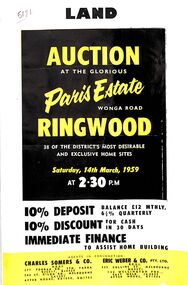 Ringwood and District Historical Society
Flyer, Land Auction Advertisement, Paris Estate, Ringwood, Vic. - 1959
... , locality map, subdivision features and summary of local services...., 14th March, 1959, with terms of sale, locality map, subdivision ...Double sided single page black and yellow printed advertisement for auction of home sites at Paris Estate, Wonga Road, Ringwood, Vic., on Saturday, 14th March, 1959, with terms of sale, locality map, subdivision features and summary of local services.Subdivision includes Mullum Mullum Road, Hendra Grove, Sunhill Road, and Wonga Road. Agents in conjunction: Charles Somers & Co., South Yarra and Melbourne, and Eric Weber & Co., Melbourne and East Melbourne.