Showing 659 items matching "survey plan"
-
 Eltham District Historical Society Inc
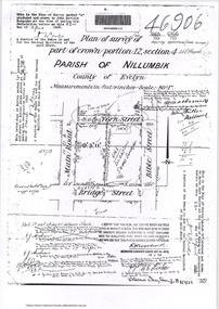
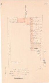
Document - Photocopy, Survey Fleld Notes of Part of Crown Portion 12, Section 4 at Eltham, Parish of Nillumbik, County of Evelyn, 18 March 1926
... Survey Plan... Street Eltham Main Road Map Survey Plan York Street A4 printouts ...Portion of land bounded by: Main Road, York Street, Bible Street, Bridge Street Application 46906 R.H. Woodcock, Licensed Surveyor, 18 March 1926application 46906, bible street, bridge street, eltham, main road, map, survey plan, york street -
 Eltham District Historical Society Inc
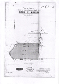
Document - Photocopy, Survey Fleld Notes of Part of Crown Portions 12 & 13, Section 4 at Eltham, Parish of Nillumbik, County of Evelyn, 6 May 1929
... Survey Plan... Main Road Map Survey Plan Swan Street York Street A4 printouts ...Portion of land bounded by: Main Road, York Street, Diamond Creek, Swan Street Application 48223 P.N. Guy, Licensed Surveyor, 6 May 1929application 48223, diamond creek (creek), eltham, main road, map, survey plan, swan street, york street -
 Bayside Gallery - Bayside City Council Art & Heritage Collection
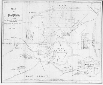
Map, H.B. Foot, Plan of the Brighton Estate containing 5120 acres, first special survey at Port Phillip, c. 1842
... Survey Henry Dendy Jonathan Binns Were W.B. Were survey plan map ...This plan records the Brighton Estate, also known as Dendy's Special Survey. In 1840 Henry Dendy, a farmer in Surrey, England acquired a "Special Survey" from the Commissioners for Land and Emigration which gave him the right to choose land in Port Phillip for the low price of £1 per acre for 5120 acres. Dendy appointed Jonathan Binns Were, as his agent, who later became a partner. Together, Dendy and Were decided on an area 5 miles south from Melbourne, bounded by North Road, East Boundary Road, South Road and to the west by Port Phillip Bay. Their Brighton Estate was first surveyed by T. S. Townsend in May 1841 and was re-surveyed by Robert Hoddle. Dendy and Were were making plans to sell the land and advertised a 30-guinea prize for the best subdivision which was to be divided into a village, marine residences, suburban and cultivation allotments, with the remainder being divided into country sections. The competition was won by H.B. Foot, who planned the village around a reserve and crescents and a 'green belt' forming the town boundary. brighton estate, dendy's special survey, special survey, henry dendy, jonathan binns were, w.b. were, survey, plan, map, brighton, george ward cole, baker's lithographer, hibernian, subdivision, town planning, cartographic material, h.b. foot -
 Bendigo Historical Society Inc.
Plan - MCCOLL, RANKIN AND STANISTREET COLLECTION: PLAN OF SURVEY OF DAM SITE, 1941
... MCCOLL, RANKIN AND STANISTREET COLLECTION: PLAN OF SURVEY... Plan of Survey of Dam site...McColl Rankin & Stanistreet, Plan of Survey of Dam site... & Stanistreet Plan of Survey of Dam site McColl Rankin & Stanistreet ...McColl Rankin & Stanistreet, Plan of Survey of Dam site, Part of Crown Allotment 98 Section C, City of Bendigo, Parish of Sandhurst, County of Bendigo. Signed by Garnet G Birch 1 Feb 1941. 33.5 x 43. Attached is a Copy of Field notes, Dam Site in Crown Allotment 198 Sec. City of Bendigo, Parish of Sandhurst. True Meridian, County of Bendigo, Area 0A 1R 16P. Signed Garnet G Birch, 1/2/1941. Drawn in red and black pen. 20.8 x 33. Both maps are for Deborah Extended Gold Mining Co. No Liabilityorganization, mining, deborah extended gold mining co nl, mccoll rankin & stanistreet, plan of survey of dam site -
 Ringwood and District Historical Society
Photograph, Map of Melbourne & Vicinity - 1853. Survey of Port Phillip. Plan in Bonwick's "Settlement of Port Phillip"
... Map of Melbourne & Vicinity - 1853. Survey of Port Phillip.... Survey of Port Phillip. Plan in Bonwick's "Settlement of Port... of Melbourne & Vicinity - 1853. Survey of Port Phillip. Plan ...Catalogue card reads, 'Map of Melbourne & Vicinity - 1853. Survey of Port Phillip. Plan in Bonwick's "Settlement of Port Phillip"'. -
 Federation University Historical Collection
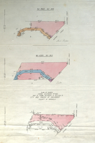
Plan, Plan of Survey Crown Allotment 9A and Part of Crown Allotment 8 Section 10 City and Parish of Ballaarat, after 1929
... Plan of Survey Crown Allotment 9A and Part of Crown...plan of survey... ballaraat ballarat plan plan of survey armstrong street skipton ...ink and watercolor on watermarked laid paper dated 1928text and measurementsballaraat, ballarat, plan, plan of survey, armstrong street, skipton street -
 Federation University Historical Collection
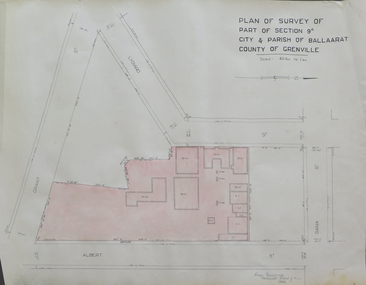
Plan, Plan of Survey of Part of Section 9A City & Parish of Ballarat County of Grenville (Albert Street frontage), 1932
... Plan of Survey of Part of Section 9A City & Parish of... Plan of Survey of Part of Section 9A City & Parish of Ballarat ...The M.B. John Trade Building was built on the Albert Street Frontage..1) Plan of SMB showing Albert, Grant, Lydiard and Dana streets, on paper with colored highlights undertaken by Ballarat School of Mines student George Murrowood in 1932 .2) Hand written page by George Murrowood, of technical description of land surveying Grade II 1932ballarat school of mines, surveying, george murrowood, albert street, alumni, m.b. john building, architectural plan -
 Ringwood and District Historical Society
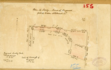
Map, Plan of Survey, Parish of Ringwood - Part of Crown Allotment 31A - 1950
... Plan of Survey, Parish of Ringwood - Part of Crown... drawn and labelled copy of map with survey measurements ...Hand drawn and labelled copy of map with survey measurements of allotment on Isobel Avenue (Isabel Avenue?), Ringwood East. Raymond Dudley Steele Licensed Surveyor 10-8-50, signed 6-9-50, Seal of Borough of Ringwood 26-9-50. Rubber stamp - Dugdale, Simmons & Stevens, Solicitors, Peacock House, 486 Bourke Street Melbourne. Typewritten heading on backing paper - Capt. M.H. Moyes - Correspondence Supplementary to Statements. -
 Bacchus Marsh & District Historical Society
Map, Plan of Survey of Part of Crown Allotment 9, Parish of Korkuperrimul, 1890
... Plan of Survey of Part of Crown Allotment 9, Parish of... stored on BMDHS computer network. Plan of Survey of Part of Crown ...This map documents a transfer of an allotment of land in Clarke Street Bacchus Marsh in 1890. Clarke Street is located on the eastern side of Bacchus Marsh not far from Main Street and Crook Street. It is now known as Candeloro Street. The map indicates J. Booth as the owner of the land and H. Simpson as the occupier. Next to this allotment is a an allotment of land owned by J. Elmore,Single page map showing Crown allotment 9, Parish of Korkuperrimul, County of Bourke. Scale 100 feet to inch. Part of a set of maps which are pasted into a bound volume containing 76 maps or plans in total. High resolution digital image stored on BMDHS computer network. At bottom of map: I hereby certify that I have made this survey expressly for the purpose of an application under the Transfer of Land Statute that this plan is correct. Barry B???, Lic. Surveyor, 16.10.90bacchus marsh victoria maps, clarke street bacchus marsh maps -
 Ringwood and District Historical Society
Map, Plan of Survey, Part of CP12, Adelaide Street, Ringwood, Circa 1920s
... Plan of Survey, Part of CP12, Adelaide Street, Ringwood... Surveyor 36 Narissa Street Burwood BX1917. Plan of Survey, Part ...Undated map of part of commercial area in Parish of Ringwood, County of Mornington showing Adelaide Street, Whitehorse Road, and un-named laneway behind Whitehorse Road shops marked as Road, and New Road Alignment. Made by H.J. Macey, Licensed Surveyor 36 Narissa Street Burwood BX1917. -
 University of Melbourne, Burnley Campus Archives
Plan, Richmond Park, 1926-1954
... Photocopy of Section of a Survey Plan 1926 showing fencing... of a Survey Plan 1926 showing fencing and hedging dated 1927. Stamp ...Photocopy of Section of a Survey Plan 1926 showing fencing and hedging dated 1927. Stamp, Department of Lands and Survey 8.9.54 (Original plan dated 25.3.27) Part of handwritten notes signed "M. Anderson ? 28/2/45."parks, richmond, burnley gardens, orchards -
 Ringwood and District Historical Society
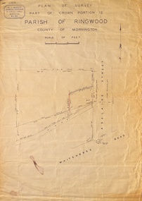
Map - Plan of Survey, Part of Crown Portion 12, Parish of Ringwood, Victoria - circa 1930
... Plan of Survey..., Victoria - circa 1930. Map Plan of Survey ...Map of area bounded by Ringwood Street, Melbourne Street and Adelaide Street, showing details of Adelaide Street allotments and existing outbuildings. Certificate of Title numbers include Ringwood Street C/T 3418-553, C/T 3563-433, Adelaide Street C/T 7151-047, C/T 7038-465, C/T 7098-464, C/T 7098-465, C/T 3604-635, C/T 8066-900, C/T 3866-118, C/T 3609-728, and C/T Vol 3670 Fol 133992.Subsequent additional notations identifying 1971 closure of Melbourne Street North, and properties of Hone, Patendon, Pines Hosptial, Mail Office, Presbyterian Church and Falconers Grocery Shop on Whitehorse Road corner. -
 Bendigo Historical Society Inc.
Map - PLAN GENERAL SURVEY MALMSBURY PORCUPINE INN, FOREST CREEK TO GOLDEN POINT. ALEXANDRA RANGE 1853
... PLAN GENERAL SURVEY MALMSBURY PORCUPINE INN, FOREST CREEK...Colour Copy of Plan of the General Survey from the Town... Victoria by Gerry Gill. Map PLAN GENERAL SURVEY MALMSBURY PORCUPINE ...Colour Copy of Plan of the General Survey from the Town of Malmsbury to the Porcupine Inn, from the sources of Forest Creek to Golden Point, shewing (sic) the Alexandrian Range also Sawpit Gully Bendigo and Bullock Creeks. Handwritten note under the title a follows '' Forwarded to the Colonial Secretary with my letter No A 53/105 dated 30th March 1853 for transmission to the Geological Surveyor. R Hoddle Surveyor General. ' Stamped by Department of Mines Victoria with record#123 in Top right Hand corner. Also contains a catalogue number 2053/M/2. Part of the Contents of a DVD entitled 'Mapping Great Change' - Archival Maps, produced to support an exhibition in the Post Office Gallery Bendigo. A description of the Map, its history and implications for both historical and future discussions is contained in an Essay 'Mapping Great Changes' : The landscape of central Victoria by Gerry Gill.R. Hoddlemap, bendigo, country lands -
University of Melbourne, Burnley Campus Archives
Plan, Detail Plan of Victoria Park, 1976
... . Survey Plan, Sheet 1 of 2 by Alan Baker, Terry Martin, Richard... July 1976. Survey Plan, Sheet 1 of 2 by Alan Baker, Terry ...Swinburne College of Technology Ltd. Plan dated July 1976. Survey Plan, Sheet 1 of 2 by Alan Baker, Terry Martin, Richard Yeoman.swinburne college of technology, alan baker, terry martin, richard yeoman, kew -
University of Melbourne, Burnley Campus Archives
Plan, Victoria University of Technology Melton Campus, 1994
... Photocopy of 'Feature and Level Survey' plan by WBCM group...victoria university of technology melton WBCM Surveys Pty ...Photocopy of 'Feature and Level Survey' plan by WBCM group. Job No 4776/5 Sheet 1 of 1. Compilation Sheet Part of 477630A and 477631A. Dated 06.07.1994. Drawn b y RVvictoria university of technology, melton, wbcm surveys pty. ltd., feature survey -
Whitehorse Historical Society Inc.
Map, Burwood Road, Box Hill City, 15/02/1952 12:00:00 AM
... . Marked as 'Survey Plan No 5440'..... Marked as 'Survey Plan No 5440'. Burwood Road, Box Hill City Map ...Detailed map of subdivision along the north side of Burwood Road, Box Hill between Station Street and Middleborough Road.Detailed map of subdivision along the north side of Burwood Road, Box Hill between Station Street and Middleborough Road. Shows many block owners, types of buildings, nature of fencing. Marked as 'Survey Plan No 5440'.Detailed map of subdivision along the north side of Burwood Road, Box Hill between Station Street and Middleborough Road. maps, burwood road, burwood, andrews street, greenwood street, tennyson street, middleborough road, station street -
Clunes Museum
Map - MAPS/ DOCUMENTS, CIRCA 1857
... FEBRUARY, 1857. COUNTY OF TALBOT - GOLDFIELD'S SURVEY PLAN NO.1... SURVEY PLAN NO.1 CLUNES COUNTY OF TALBOT. GLENDONALD - CRESWICK ...COLLECTION OF DOCUMENTS (COPIES OF10 MAPS AND DIAGRAMS OF TOURAAL PURCHASED UNDER PREEMPTIVE RIGHT BY DONALD CAMEROM 17TH FEBRUARY, 1857. COUNTY OF TALBOT - GOLDFIELD'S SURVEY PLAN NO.1 CLUNES COUNTY OF TALBOT. GLENDONALD - CRESWICK/CLUNES.local history, mining -
 Greensborough Historical Society
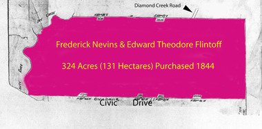
Folder of documents, Flintoff - various documents, 1844_
... in the Greensborough area. Includes a survey plan for acquisition of land... a survey plan for acquisition of land for the aqueduct 1897 ...Records the Flintoff family's ownership of parcels of land in the Greensborough area. Includes a survey plan for acquisition of land for the aqueduct 1897.Various photocopies of title documents relating to land owned by the Flintoff family in Greensborough.Mainly handwritten documents dating from early 20th century.flintoff family, land titles, greensborough, aqueduct -
 Bendigo Historical Society Inc.
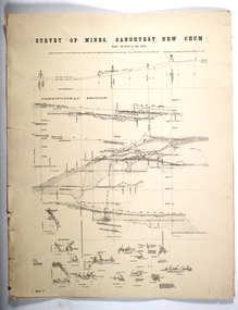
Map - SURVEY OF MINES, SANDHURST, NEW CHUM, Circa 1881
... MAP mining plan Survey of Mines Sandhurst New Chum Gold ...Map: Survey of Mines, Sandhurst, New Chum, Longtitudinal Section of the New Chum, reef. 2 sheets. Sheet 5 and Sheet 8map, mining plan, survey of mines , sandhurst, new chum, gold mines bendigo -
Bendigo Historical Society Inc.
Plan - SANDHURST BOYS CENTRE SITE PLANS: LISLE STREET UNITS
... Survey Plan for Lot 69D 3950 Sq m. Location unknown 16.02.2023.... Inc. History House 11 Mackenzie Street Bendigo goldfields PLAN ...16 Working drawings including Floor Plans and Elevations Prepared by Michael DeVincentis, Architects; Wellington St Strathfieldsaye. October-November 1995. Scale 1:200. No 9538. Also Survey Plan for Lot 69D 3950 Sq m. Location unknown 16.02.2023.plan, bendigo, institutions, victoria. department of planning and development -
University of Melbourne, Burnley Campus Archives
Plan, Wilsons Promontory8119-I and Glennie 8119-IV, 1971
... State Aerial Survey Plan of Wilsons Promontory and Glennie... aerial survey State Aerial Survey Plan of Wilsons Promontory ...State Aerial Survey Plan of Wilsons Promontory and Glennie. Dated 1971. Provisional Compilation of Sheets 8119-I and 8119-IV from Commonwealth Department of National Development Photography for the Department of Crown Lands and Survey Victoria. Students made excursions to Wilsons Promontory.wilsons promontory, glennie group, anser group, bass strait, aerial survey -
Port Melbourne Historical & Preservation Society
Document - Reports, Planning, development and traffic management, Loder & Bayly, 1974 - 1978
... 12 surveys re planning, development and traffic management... - zoning loder & bayly glen cosham 12 surveys re planning ...12 surveys re planning, development and traffic management carried out by Loder & Bayly, August 1974 to February 1978local government - city of port melbourne, town planning, transport - roads, built environment - commercial, built environment - zoning, loder & bayly, glen cosham -
Stawell Historical Society Inc
Map, Gold Mines of Australia, Gold Mines of Australia underground workings. Newington Rd Darlington Rd Area 1950, 1950
... Plans Showing Surveys & Drilling Stawell Investment... 2003 Plans Showing Surveys & Drilling Stawell Investment Gold ...Plans Showing Surveys & Drilling Stawell InvestmentGold Mines of Australia Stawell Investment 2003 mining, gold, map -
Bendigo Historical Society Inc.
Photograph - FORTUNA COLLECTION: FORTUNA VILLA, circa 1970
... 'The Sun' April 8th 1970 referring to the Army Survey Regiment's... PHOTOGRAPH Landscape bendigo Fortuna Villa Survey Regiment The Sun ...Photograph: Fortuna Villa and a newspaper clipping from 'The Sun' April 8th 1970 referring to the Army Survey Regiment's plan to move out of the building. On a cardboard backingphotograph, landscape, bendigo, fortuna villa, survey regiment, the sun april 8th 1970 -
Kiewa Valley Historical Society
Papers - Mt Beauty Airport Development
... Survey Plan of Airstrip 1975 4. Large folder titled Mr J. R... Survey Plan of Airstrip 1975 4. Large folder titled Mr J. R ...The SECV began investigating four possible sites for an airstrip in Mt Beauty in 1965. The land was owned by the SEC and leased by Mr J. Sharp. It became available on the condition that the land would only be available to the Municipal shire. This land was officially opened as an Airport as an official tourist activity in 1977. It continues to be available to tourists, fire fighters, the air ambulance and the local gliding club.The opening of Mt Beauty Airport has enhanced Mt Beauty township by enabling fire fighters to access the surrounding bush during bush fires, by enabling Ambulance helicopters to rush emergency patients to city hospital, by giving tourists the opportunity to fly in and to give the local Gliding Club the opportunity to store and fly their gliders. 1. Set of papers titled 'History Mt Beauty Airport Development' held together by large steel clip by Alex McCullough. 2. Set of papers titled 'Department of Transport' and 'Alpine Shire' both held together by one staple. 3.Mt Beauty Township Survey Plan of Airstrip 1975 4. Large folder titled Mr J. R. Sharp 1975 - Mt Beauty Airfieldmt beauty airport history, alex mccullough, transport, tourism -
Federation University Historical Collection
Book, University of Ballarat Interim Strategic Plan, 1997, 1989
... * Finanace Database Volume Statistics * Client Survey - PLanning... * Finanace Database Volume Statistics * Client Survey - PLanning ...A4 book compiled by the University of Ballarat Financial and Resource Services Branch. Appendices include: * Statutory requirements for Financial & Planning Services Branch * Halls of Residence Strategic Plan * Campus Amentities Strategic Plan * Finanace Database Volume Statistics * Client Survey - PLanning Services and Budgeting Services * Recent In-House I.T. Development * Processes to be investigated/Introduced Tables include: * Staffing by level, gender and age * Fianancial & Resource Services Budget, 1997 * Fianancial & Resource Services Budget, 1998 strategic plan, fiancial planning, robert hook, mission, vision, values, staffing, information technology, halls of residence, student accomodation -
 Bendigo Military Museum
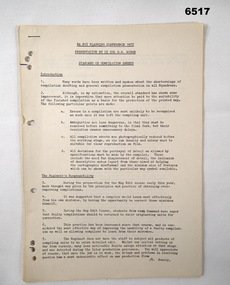
Administrative record - Royal Australian Survey Corps Planning Conference 1972 - Standard of Compilation sheets by LtCol DR Ridge (RASvy), LtCol DR Ridge (RASvy), Fortuna Bendigo, Circa 1972
... at the Royal Australian Survey Corps Planning Conference 1972 held... at the Royal Australian Survey Corps Planning Conference 1972 held ...This is a paper that was prepared for and delivered at the Royal Australian Survey Corps Planning Conference 1972 held at Fortuna Bendigo. The paper was written and delivered by LtCol DR Ridge RASvy.A 6 x A4 page report with typed text, stapled and four hole punchedroyal australian survey corps, rasvy, fortuna, army survey regiment, army svy regt, asr -
 Bacchus Marsh & District Historical Society
Map, Limestone Reserve Parish of Merrimu 1888
... Copy of plan surveyed by Mr. G? [illegible] an authorised... Alkemade Family Coimadai Copy of plan surveyed by Mr. G? [illegible ...Limestone deposits in the Coimadai area 10 kilometers north of Ballarat were first worked in the 1850s. The area was quarried for limestone for many years by various people and companies. The surveyor's name who produced this plan is inscribed on the map and below this is the name P. L. Alkemade, who presumably paid for the map to be produced. In 1886 Petrus Alkemade in partnership with Matthew Egan established the Alkemade Hydraulic Lime and Cement Company. The Alkemade family were involved in the limestone industry over several generations at Coimadai.Single page map showing part of the Limestone reserve near Coimadai in the Parish of Merrimu. Scale 4 chains to 1 inch. Part of a set of maps which are pasted into a bound volume containing 76 maps or plans in total. High resolution digital image stored on BMDHS computer network. Copy of plan surveyed by Mr. G? [illegible] an authorised surveyor on 17th July 1888. P. L. Alkemadebacchus marsh victoria maps, lime kilns coimadai, limestone, coimadai victoria maps, alkemade family coimadai -
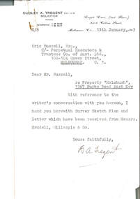 Melbourne Legacy
Document, re Property "Holmbush", 1267 Burke Road East Kew, 1943
... Committee, enclosing the survey sketch plan. White paper, black... punched for filing 00310.2 Survey sketch plan by Meudell ...Formal identification of the property to be bought as the first Melbourne Legacy residence sent to Legatee E. Russell, Chair of the Hostel Committee. The survey is hand drawn and meticulously measured.The documents demonstrate business practices in the 1940s with regard to the purchase of property, as well as being an important record of the first property to be purchased by Melbourne Legacy as a residence for children.00310.1 Letter from Dudley A. Tregent, Solicitor, dated 15 January 1943, to Legatee E. Russell, Chair of the Hostel Committee, enclosing the survey sketch plan. White paper, black letterhead and typing, two holes punched for filing 00310.2 Survey sketch plan by Meudell, Gillespie & Co, dated 13 January 1943. Black type and printing, with some red shading and writing, on white foolscap paper. 00310.3 Letter from Meudell, Gillespie & Co to Mr. D.A. Tregent, Solicitor. Quarto, black typing, red underlining, on white.00310.1 Signed by D.A. Tregent 00310.2 Signed by Percival A. Jordan 00310.3 Signed by Percival A. Jordanholmbush initial negotiations, properties, holmbush -
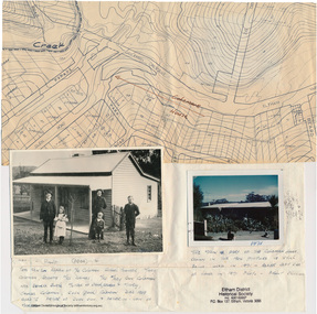 Eltham District Historical Society Inc
Folder, Colemans Corner, Eltham
... and 1678A) Photo of "Coleman's house", 1971 Survey plan showing... and 1678A) Photo of "Coleman's house", 1971 Survey plan showing ...Letter from Nillumbik Council to H.Gilham in response to consultation on Wattletree Road Bridge replacement, 13 August 2007, 1p. VicRoads brochure on Wattletree Road bridge replacement project, August 2007, 1p Photo of "Coleman's house", 1904 with brief family history. (Photo retrieved by Harry Gilham from from a 1972 'time capsule bucket' found at the Eltham Shire Office during its demolition in July-August 1996 (See also SEPP_0745 and 1678A) Photo of "Coleman's house", 1971 Survey plan showing location of Coleman's houseFolder of information and photos relating to the Colemans Corner precinct located on the corner of Main Road and Wattletree Road, Eltham. HG Booklet 9bus services, wattletree road bridge, coleman family, coleman's corner, harry gilham collection