Showing 42 items
matching swamp creek
-
 City of Kingston
Photograph - Colour, Paul Tresize, 1998
The name Mordialloc was derived from the name Moody Yallock, which comes from the Bunurong language. The Bunurong Peoples are the Traditional Owners of this area. The name means “high water” or “high creek”. In 1839, colonial authorities declared the mouth of the creek, and an additional 830 odd acres as an Aboriginal Reserve, although this proclamation was never gazetted. The reserved land included part of the Carrum Carrum Swamp which was abundant with wild life and natural resources. Regular encroachments, including land sales which began in 1863, were made on the land until 1878 when the Reserve was declared closed, and the land was opened up to land sales. Market gardening and suburban house lots quickly began to develop, and Mordialloc became a renowned picnic and holiday site. Mordialloc Creek is a popular bay side destination for local and visitors, and is a site for boating, kayaking, fishing and swimming, along with many other activities.Colour photograph of Mordialloc Creek, looking out to the bay. Many small fishing and leisure craft are moored on either side of the banks of the creek. To the right hand side can be seen parklands, while the left hand side has a small inlet in which more small crafts are moored.mordialloc, bunurong, traditional owners, suburbs, boats, fishing, waterways -
 City of Kingston
Photograph - Colour, 1998
The name Mordialloc was derived from the name Moody Yallock, which comes from the Bunurong language. The Bunurong Peoples are the Traditional Owners of this area. The name means “high water” or “high creek”. In 1839, colonial authorities declared the mouth of the creek, and an additional 830 odd acres as an Aboriginal Reserve, although this proclamation was never gazetted. The reserved land included part of the Carrum Carrum Swamp which was abundant with wild life and natural resources. Regular encroachments, including land sales which began in 1863, were made on the land until 1878 when the Reserve was declared closed, and the land was opened up to land sales. Market gardening and suburban house lots quickly began to develop, and Mordialloc became a renowned picnic and holiday site. Mordialloc Creek is a popular bay side destination for local and visitors, and is a site for boating, kayaking, fishing and swimming, along with many other activities.Colour photograph of Mordialloc Creek, looking inland.Small fishing and leisure boats are moored on either side of creek, with a view of the Mordialloc Bridge Hotel in the background.mordialloc, bunurong, traditional owners, suburbs, boats, fishing, waterways, hotel -
 City of Kingston
Photograph - Colour, Paul Tresize, 1998
The name Mordialloc was derived from the name Moody Yallock, which comes from the Bunurong language. The Bunurong Peoples are the Traditional Owners of this area. The name means “high water” or “high creek”. In 1839, colonial authorities declared the mouth of the creek, and an additional 830 odd acres as an Aboriginal Reserve, although this proclamation was never gazetted. The reserved land included part of the Carrum Carrum Swamp which was abundant with wild life and natural resources. Regular encroachments, including land sales which began in 1863, were made on the land until 1878 when the Reserve was declared closed, and the land was opened up to land sales. Market gardening and suburban house lots quickly began to develop, and Mordialloc became a renowned picnic and holiday site. Mordialloc Creek is a popular bay side destination for local and visitors, and is a site for boating, kayaking, fishing and swimming, along with many other activities.Colour photograph of Mordialloc Creek, looking inland. Boats are moored on either side of the creek and the Bridge Hotel is visible in the background.mordialloc, bunurong, traditional owners, suburbs, boats, fishing, waterways, hotel -
 City of Kingston
Photograph - Colour, Paul Tresize, 1998
The name Mordialloc was derived from the name Moody Yallock, which comes from the Bunurong language. The Bunurong Peoples are the Traditional Owners of this area. The name means “high water” or “high creek”. In 1839, colonial authorities declared the mouth of the creek, and an additional 830 odd acres as an Aboriginal Reserve, although this proclamation was never gazetted. The reserved land included part of the Carrum Carrum Swamp which was abundant with wild life and natural resources. Regular encroachments, including land sales which began in 1863, were made on the land until 1878 when the Reserve was declared closed, and the land was opened up to land sales. Market gardening and suburban house lots quickly began to develop, and Mordialloc became a renowned picnic and holiday site. Mordialloc Creek is a popular bay side destination for local and visitors, and is a site for boating, kayaking, fishing and swimming, along with many other activities.Colour photograph of Mordialloc Creek with boats moored on both sides of the street and Pompei's boat yard visible on the right hand side of the creek., Main Street and St Brigid's Catholic Church are visible in backgroundmordialloc, bunurong, traditional owners, suburbs, boats, fishing, waterways, hotel, church -
City of Kingston
Photograph - Colour, Paul Tresize, 1998
The name Mordialloc was derived from the name Moody Yallock, which comes from the Bunurong language. The Bunurong Peoples are the Traditional Owners of this area. The name means “high water” or “high creek”. In 1839, colonial authorities declared the mouth of the creek, and an additional 830 odd acres as an Aboriginal Reserve, although this proclamation was never gazetted. The reserved land included part of the Carrum Carrum Swamp which was abundant with wild life and natural resources. Regular encroachments, including land sales which began in 1863, were made on the land until 1878 when the Reserve was declared closed, and the land was opened up to land sales. Market gardening and suburban house lots quickly began to develop, and Mordialloc became a renowned picnic and holiday site. Mordialloc Creek is a popular bay side destination for local and visitors, and is a site for boating, kayaking, fishing and swimming, along with many other activities.Colour photograph of Mordialloc Creek with boats moored on both sides of the street and Pompei's boat yard visible on the right hand side of the creek., Main Street and St Brigid's Catholic Church are visible in background.mordialloc, bunurong, traditional owners, boats, fishing -
City of Kingston
Photograph - Colour, 31 January 1993
... Creek were previously part of the extensive Carrum Carrum Swamp ...Patterson Lakes is a suburb in the City of Kingston that is built one kilometre upstream of the mouth of the Patterson River. The area is bordered by the Patterson River and Eel Race Drain which enters the Kananook Creek. The suburb consists predominantly of newer housing developments and the tidal canal system of the development joins Port Phillip Bay. Patterson Lakes and the Kananook Creek were previously part of the extensive Carrum Carrum Swamp. The area was once a source of fish and eels for the Mayone-Bulluk clan of the Bunurong people. Over time the area was drained and in 1973 investigations commenced into the development of a unique residential area that would be built adjacent to canals and waterways. It was originally proposed to be known as "Gladesville". The development would give the suburb's homeowners access to Port Phillip Bay "from their back door". Circa 1974, the area was rezoned from rural to residential and named Patterson Lakes. Development has been continuous since the 1970s with construction of residential housing, schools, shopping centres, marinas, a hotel and library.Laminated colour aerial photograph of the Carrum and Patterson Lakes region within City of Kingston. This 1993 image includes Patterson River Secondary College, Roy Dore Reserve, Kananook Creek and Nepean Highway. The railway line can be seen as it veers inland from Eel Race Road, Seaford. The section of Ocean Reef Drive and Palm Beach Drive in Patterson Lakes appears to be a recent development with many spare blocks and new houses under construction.Black typed lettering on white adhesive label: 31.1.93 Black typed lettering on white adhesive label: 27E/7140 31/1/93 12.55 pm Black typed lettering on white label: 7140 Yellow round adhesive label located on left sidepatterson lakes, seaford, kananook creek, carrum carrum swamp, canals and waterways -
City of Kingston
Photograph - Colour, c. 1993
... Creek were previously part of the extensive Carrum Carrum Swamp ...Patterson Lakes is a suburb in the City of Kingston that is built one kilometre upstream of the mouth of the Patterson River. The area is bordered by the Patterson River and Eel Race Drain which enters the Kananook Creek. The suburb consists predominantly of newer housing developments and the tidal canal system of the development joins Port Phillip Bay.Patterson Lakes and the Kananook Creek were previously part of the extensive Carrum Carrum Swamp. The area was once a source of fish and eels for the Mayone-Bulluk clan of the Bunurong people. Over time the area was drained and in 1973 investigations commenced into the development of a unique residential area that would be built adjacent to canals and waterways. It was originally proposed to be known as "Gladesville". The development would give the suburb's homeowners access to Port Phillip Bay "from their back door". Circa 1974, the area was rezoned from rural to residential and named Patterson Lakes. Development has been continuous since the 1970s with construction of residential housing, schools, shopping centres, marinas, a hotel and library.Laminated colour aerial photograph of the Carrum and Patterson Lakes region within City of Kingston. This 1993 image includes Patterson River Secondary College, Roy Dore Reserve, Kananook Creek and Nepean Highway. The railway line can be seen as it veers inland from Eel Race Road, Seaford. The section of Palm Beach Drive, Curlew Point Drive, Snapper Point Drive, Clipper Island and Myola Street in Patterson Lakes appears to be a recent development with many spare blocks and new houses under construction.patterson lakes, seaford, kananook creek, carrum carrum swamp, canals and waterways -
City of Kingston
Photograph - Colour, 1993
Carrum is a suburb in the City of Kingston bordered by the Patterson River in the north and Kananook Creek in the south. To the east the suburb is adjacent to Patterson Lakes. The Carrum Station was opened in 1882, when the railway line from Mordialloc was extended to Frankston. In the early 20th century, it was a destination for holidaymakers occupying tents and cabins. The area now consists of older housing and over time there have been many new housing developments.Carrum is located in the area that was originally part of the Carrum Carrum Swamp. The district had originally been the home of the Bunerong people who fished, gathered food and found refuge in the sand dunes. The Swamp was drained in 1879 when the Patterson Cut was formed and became known as Patterson River. Apart from local farmers, fishermen and hotel-keepers, there were few permanent residents until the early 20th century when it had become popular as a beach resort. In the 1920s and 1930s the area became occupied by more permanent residents.Laminated aerial colour photograph of Carrum and Patterson Lakes in the City of Kingston. The photograph also includes Kananook Creek and the northern section of Seaford. Prominent features include Roy Dore Reserve, Carrum Primary School, Patterson River Secondary College, Keast Park Seaford, the Seaford Swamp Drain and a section of Downs Estate situated on the traditional lands of the Bunurong people.Black type on white adhesive sticker: No. 7140 Black type of white adhesive sticker: 31-1-93 Black handwritten ink (marker): * [an asterisk] Yellow circular adhesive stickerpatterson lakes, seaford, carrum carrum swamp -
 Federation University Historical Collection
Map, Ballarat Goldfield, c1898
... Leigh Creek Black Swamp Lead Yorkshire Reef Nil Desperandum reef ...This map shows geological features, suggests the last basalt flow, and includes alotments and names of Mining Companies. Although this map has no date on it the Ballarat Industrial School is used for dating purposed. The Ballarat Industrial School ran from 1869-1879, but the term Ballarat Industrial School Reserve was still in use in 1898 and possibly beyond.Geological Map of Ballarat with 3 holes in the left hand side. The map indicates the position of Lake Wendouree, Township of Warrenheip, Ballarat East, Industrial School Reserve, Winters Swamp, Police Paddock, Wyndholm Premptive Right (Salton and Waldie), Black Hill, Vale Park Reserve, Pennyweight Hill, Little Bendigo, Black Swamp Lead, monte Christo Reef, Chinaman's Gully, Miners Rest, Pincotts Dam, Northumberland Gully. It also show the following goldmining companies: City of Ballarat, Kohinor, Hand and Band, Great North West, Northern Junction, Kneeshaw, Rossers Freehold, Silurial.ballarat, warrenheip, lake wendouree, ballarat east, winters swamp, winter swamp, wyndholm premptive right, cemetery, vale park reserve, little bendigo, kneeshaw co., industrial school reserve, kirks dam, pincotts dam, black hill, wombat hill, dead horse gully, miners rest, mt rowan, salton and waldie, rose hill co, great north west no 1, rose's freehold co, hand and band co, police reserve, police paddock, mount rowan, ballarat industrial school reserve, market reserve, winter's swamp, kneeshar co, monte cristo line of reef, chinaman's gully or black snake, milkmaid's gully, ballarat gold field, bakery hil lead, old gravel pits lead, golden point lead, eureka lead, miner's rest, yarrowee creek, leigh creek, black swamp lead, yorkshire reef, nil desperandum reef, cockatoo lead, hit or miss gully, herbert werner frederick de nully, pennyweight hill, esmond's lead, ash's lead, nightingale lead, john bull gully, gladstone reef, whitehorse reef, petticoat creek, pincott's dam, frenchman's gully, tim's crushing plant, jenkin's gully, california gully, drake's creek, sulton and waldie, ballarat undustrial school, ballarat & mariborough railway -
 Federation University Historical Collection
Book, Final recommendations Ballarat Study Area Land Conservation Council, Victoria, 1982, 1982
Yellow soft covered report of 95 pages . The contents of the report include: Parks, reference areas, wildlife reserves, water production, harwood production, softwood production, flora Reserves and Flora and Fauna reserves, bushland reserves, historic area and reserves, rivers and streams, Roadside conservation and Highway parks, Education areas and School Plantations, Lake Reserves, geological reserves, recreation, scenic reserves, agriculture, mineral and stone production, utilities and survey, township land, Uncommitted Land, military training, other reserves and public land. Maps include: The Study area 1: 250 000 Supplementary Mapsland conservation authority, ballarat, endowment plantations, pine plantations, langi ghiran state park, mount buangor state park, enfield state park, ballarat-creswick regional park, rossbridge, black lake, flax mill swamp, dereel lagoon, lake bolac, lake wongan, langi ghiran reservoir, gong gong reservoir, pincotts reservoir, beales reservoir, wilsons reservoir, moorabool reservoir, korweinguboora, korweinguborra reservoir, learmonth bores, sago hill, illabarook reservoir, ballarat water commission, dunneworthy, mount cole, mont lonarch, ben major, waterloo, trawalla, linton, ross creek, canadian, shepherds flat, lal lal, mount doran, raglan, chute, carngham, buninyong, watsons hill, enfield, cape clear, illabrook, rokewood junction, mount warrenheip, nerrina, jubilee, golden stream, australasian deep lead mine, happy valley school, piggoreet, berringa, bulldog, ballarat common, wildlife, water, timber, flora, rivers, geology, agriculture, warrenheip, biodiversity -
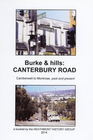 Ringwood and District Historical Society
Book, Burke & Hills: Canterbury Road Camberwell to Montrose, by Heathmont History Group - 2014
Soft cover book of 40 pages with spiral wire spine. Compilation of images and descriptive timeline of the geology, geography and European settlement history of Canterbury Road.Soon after beginning at Burke Road Camberwell, Canterbury Road moves into the gentle hills of Canterbury, then on to Surrey Hills, Box Hill and Forest Hill. Further along past these three "hills" come three "monts" - Vermont, Heathmont and at its other end, Montrose, by then in the foothills of the Dandenongs. Grand homes and churches at one end, major and minor shopping centres along the 25km, factories now where farms were, big box stores, fast food outlets, train stations, resrvoir, traffic, residential stretches, modern apartment blocks, parklands, child-minding centres, sporting ovals, a sewage farm, hotels, quarries, commercial developments, plant nurseries, a golf course, bridges, memorials, Asian food shops, telecommunication towers, bushland, creeks, crossroads, traffic lights, mansions, orchards, swamps ... Delaneys Road, renamed Canterbury Road after a 19th century Victorian Governor, is a fascinating study in land use and history as suburban Melbourne has continually diversified and pushed outwards. Compiled by Heathmont History Group, Rita James, Les Prato, Betty Colbert, Jeff Leipold, Gerry Robinson (convenor). -
 Federation University Historical Collection
Map, Ballaarat Gold Field, 1861, 1861
A party of surveyors camped by Yuille's Swamp (later Lake Wendouree) and surveyed the countryside for a map to be produced by the Geological Survey of Victoria. In November 2004 the Central Highlands Regional Library presented a special edition of 200 copies of the 1861 map reproduced from a copy in their collection. Original 1861 map of Ballarat showing streets and leads. Blue dots indicate gold leads, and red lines indicate auriferous quartz reef and outcrops of quartz veins."Compiled & Drawn from the Survey of Mining Surveyors Davidson, Fitzpatrick and Cowan & the Plans in the Surveyor General's Office by J. Brahe, 21st October 1861. R. Brough Smyth, Secretary for Mines. The Honourable J.B. Humffray, M.L.A. Commr of Mines.”ballarat, map, ballarat east, lake wendouree, survey, mines, robert davidson, ballarat gold field 1861, yuille's swamp, wendouree swamp, little bendigo diggings, gold leads, old post office hill, specimen hill, bakery hill, black hill, dead horse creek, brown hill, pennyweight hill, clayton hill, soldiers hill, golden point, gum tree flat, white flat, poverty hill, chinese village, robert brough smyth, ballarat map 1861, ballaarat vineyard, dead horse gully, deadhorse creek, invermay, black hill flat, gaelic church, police reserve, magpie range, dalton's flat, caadian lead, rifle butts, powder magazine, bathing house, government camp, gold office, chinese, llanberrris, victoria theatre, charlie napier hotel, united states hotel, grape's hoel, clayton's hill, cattleyard hill, free trade hotel, esmond lead, bakery hill, black hill lead, juvenile reformatory, ballarat orphanage, lady barkly lead, triffet's slaughter yard, little bendigo, melbourne road, t. cowan, thomas cowan