Showing 91518 items matching "tambo-shire-history"
-
 Stawell Historical Society Inc
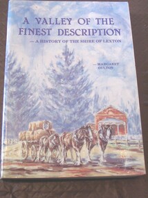
Book, Margaret Oulton, A Valley of the Finest Description - A History of the Shire of Lexton, 1995
A History of the shire of LextonCard Cover With painting showing a horse team entering Lexton on the Left of the paining is the Pyrenees Hotel, with the Lexton Court House on the right.A Valley of the Finesst Description - A History of the Shire of Lexton. Margaret Oultonstawell, lexton -
 Lakes Entrance Historical Society
Book, Tract Consultants Australia Pty Ltd and J L Sach and Associates Pty Ltd, Shire of Tambo Strategy Plan 1986, 1986
A development strategy plan prepared by Tract Consultants and J L Sach and Associates, for the Shire of Tambo, focusing in particular on the townships at the Eastern section of the Gippsland Lakes. Minimal consideration is given to the Buchan areagovernment, tourism -
 Orbost & District Historical Society
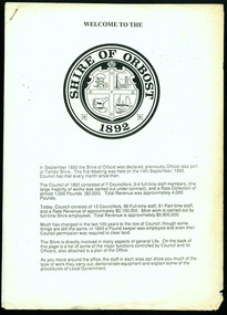
information sheet, Welcome to the Shire of Orbost, 1992
This was possibly produced for an open day in the centenary year. The Shire of Orbost was a local government area about 380 kilometres east of Melbourne. The shire covered an area of 9,347 square kilometres and existed from 1892 until 1994. Originally, Orbost was part of the Bairnsdale Road District which was created on 30 April 1867. Splitting away as part of the Shire of Tambo in 1882, Orbost was first incorporated as a shire in its own right as the Shire of Croajingolong on 30 May 1892. It received its present name on 17 February 1893. On 3 January 1913 part of its western riding was annexed to Tambo as its Cunninghame Riding. On 2 December 1994, the Shire was abolished, and merged with City and Shire of Bairnsdale, Shire of Tambo, most of the Shire of Omeo and the Boole Boole Peninsula from Shire of Rosedale into the Shire of East Gippsland. This is a useful reference tool.Two stapled pages of printed information. On the front page is the logo of Orbost Shire Council. There is information on the role of the Shire Councillors for 1992/93. It has a map of the council building.orbost-shire-council -
Marysville & District Historical Society
Article (item) - Newspaper article, The Alexandra and Eildon Standard, Indigenous history in the shire after colonisation, 08-03-2017
A newspaper article regarding indigenous history in the Murrindindi Shire after colonisation of the region.A newspaper article regarding indigenous history in the Murrindindi Shire after colonisation of the region.Wednesday, March 8, 2017alexandra, kulin, taungurung, goulburn, woi wurrung, yarra, acheron river, little river, dandenong ranges, land board, aboriginal guardian, william thomas, aboriginal station, lands minister, acheron station, mohican run, rubicon river, cathedral mountain, john green, mohican station, upper yarra, yarra tribe, woori yallock, hoddles creek, yarra river, badger creek, healesville, coranderrk, christmas bush, prostanthera lasianthos, black's spur -
 Greensborough Historical Society
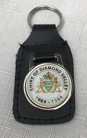
Key Ring, Shire of Diamond Valley, Shire of Diamond Valley 1964-1994 keyring, 1993c
Produced to celebrate the 30th anniversary of the Shire of Diamond Valley. The Shire of Diamond Valley was formed in 1964 and was disbanded in 1994 during the changes to local government areas.Image of enamelled crest with Shire of Diamond Valley, 1965-1995 attached to tag.Crest and wording 'Shire of Diamond Valley 1964-1994'shire of diamond valley, keyring -
 Lakes Entrance Historical Society
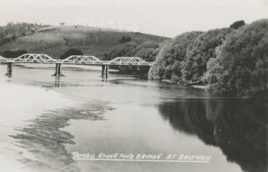
Postcard - Tambo River bridge at Bruthen Victoria, H D Bulmer
Ringbarked trees on hill in background and willows along river bankBlack and white postcard of bridge over the Tambo River at Bruthen Victoria'TAMBO RIVER BRIDGE AT BRUTHEN'agriculture, rivers, bridge -
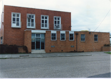 Lakes Entrance Historical Society
Photograph - Tambo Shire Office, Tambo Shire, 1994 c
Also second identical copyColour photograph of the old Tambo Shire Office, shows additions and a brick facade which was added to the original building around 1960's. Bruthen Victoria buildings, administration -
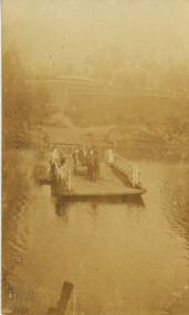 Lakes Entrance Historical Society
Postcard, Tambo Upper Punt, 1900 c
Faded postcard showing the river punt at Tambo Upper with horse and jinker on board also several people. View is looking east towards Redenbachs house and Swan Reach Bruthen road Tambo Upper Victoriatransport, waterways -
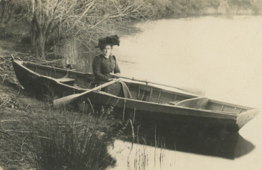 Lakes Entrance Historical Society
Postcard, Tambo River, 1900 c
Black and white postcard showing a woman in a row boat on Tambo River VictoriaB Ross on back of cardwaterways, transport -
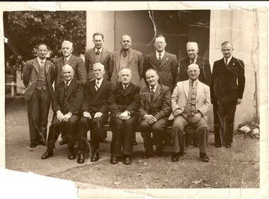 Lions Club of Maldon Inc.
Photograph, Maldon Shire Council 1948, 1948
12 Men pictured out the front of the Old Shire Hall. Maldon Shire Council 1948 Standing - Press; Cr. T.A. Grigg; Cr. Stevens, Shire Engineer; Cr. R. Bailey; Cr. A Wood; Cr. M. Allen; Cr. Wade, Shire Secretary. Seated: - Cr. T. Ottery; Cr. T. Bell; Cr. W. Rewell, Shire President; Cr. C. Talbot; Cr. B. Bryantmaldon shire council, maldon shire gardens -
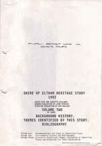 Eltham District Historical Society Inc
Document, Carlotta Kellaway, Shire of Eltham Heritage Study 1992 Volume 2 (draft): Background History - Themes identified by this study, Bibliography (pages 201-289), 1992
Shire of Eltham Heritage Study 1992 prepared by David Bick and Carlotta Kellaway; Garden Evaluation by John Patrick and Planting Evaluation by Ken Wallace Volume One: Recommendations, Conservation Areas, Identified Places Volume Two: Environmental History and Bibliography Volume Three: Culturally Significant Themes and the Evaluations of the Individually Identified Places that Illustrate the ThemesProvides the foundation for future planning assessments in the Shire of Eltham.90 A4 pages (double sided), contyained in black PVC 2-ring binder.background history, carlotta kellaway, conservation areas, culturally significant themes, david bick, garden evaluation, heritage study, identified places, john patrick, ken wallace, planting evaluation, recommendations, shire of eltham heritage study -
 Lakes Entrance Historical Society
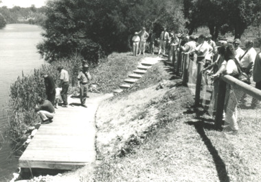
Photograph, fishing platform , Tambo River Victoria, 1/11/1994 12:00:00 AM
Black and white photograph showing crowd gathered at launch of the fishing platform installed by Tambo Nicholson Management Group and Department of Natural Resources and Environment on the bank of the Tambo River Victoria. Also three other black and white photographs showing the TAFE students under LEAP program building the fishing platform. birds, fishing, jetties -
 Lakes Entrance Historical Society
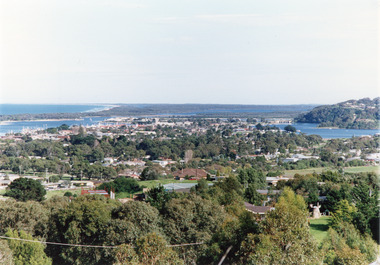
Photograph - Township, Tambo Shire, 1990c
Also second copy photographic enlargements of significant sites in the Tambo ShireColor photograph of the township, showing a distant view of the Ninety Mile Beach, the Gippsland Lakes and islands, Kalimna Heights, the bridge over the North Arm, Cunninghame Arm, and a broad view of the town and tree lined streets. Lakes Entrance Victoriabridges, topography, township, waterways -
 Marysville & District Historical Society
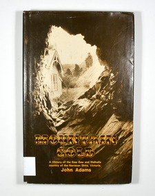
Book - Hardback book, Mountain Gold-A History of the Baw Baw and Walhalla country of the Narracan Shire, Victoria, 1980
A history of the Baw Baw and Walhalla country of the Narracan Shire, VictoriaHardback. Brown dust cover. Photograph on front cover looks out from the entry of a mine onto the front of a building which has a hill to the side of it. The back cover has a photograph of the side of a hill with some trees on it.G&V THOMAS Stamp of the Marysville & District Historical Society Inc / P.O. Box 22 / Marysville 3779gold, gold field, gold miner, gold mining, gold town, walhalla, baw baw, gippsland, victoria, australia, history -
 Greensborough Historical Society
Booklet, Shire of Corio, A Brief history of the Shire of Corio, 1980s
History of Shire of Corio, a local government area between Geelong and Werribee. The Shire included all of Geelong's northern suburbs and existed from 1861 to 1993.12 p., printed in green on white paper, photographs, stapled.geelong, shire of corio, werribee -
 Greensborough Historical Society
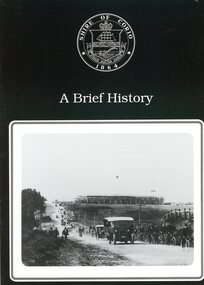
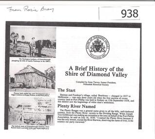
Article, Shire of Diamond Valley, A brief history of the Shire of Diamond Valley by Irene Turvey, 1837o
This brief history discusses the Shire of Diamond Valley. The Shire of Diamond Valley was a Local Government Area located about 20 kilometres northeast of Melbourne. The shire covered an area of 74.38 square kilometres and existed from 1964 until 1994.This article includes some images of early building in the Shire of Diamond Valley.Photocopied article. 4 pages text and illus.On front page "from Rosie Bray"shire of diamond valley, irene turvey -
 Greensborough Historical Society
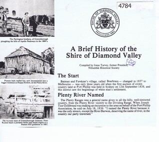
Article, Irene Turvey, A Brief history of the Shire of Diamond Valley, compiled by Irene Turvey, 1835o
Compiled by Irene Turvey, this brief history of the Shire of Diamond Valley is based on "The Diamond Valley Story" by Diane Edwards (published 1979), and includes photographs from the book.4 photocopied pages, text and photographsshire of diamond valley, diamond valley story -
 Lakes Entrance Historical Society
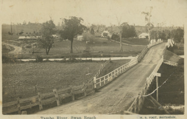
Postcard, Vogt Bairnsdale, Tambo River Swan Reach, 1920 c
Note on back to Ella from her brother Don dated 1920Black and white postcard showing the old Swan Reach bridge over the Tambo River looking east. Buildings L to R Riverslea guesthouse and school with high pitched roof. Swan Reach VictoriaTambo River Swan Reachwaterways, boats and boating, township, guesthouses, bridges -
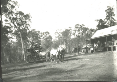 Lakes Entrance Historical Society
Photograph - Halfway House Hotel between Bruthen and Tambo Crossing Victoria, 1890 c
Double Bridges was the breakfast stop on the Bairnsdale Omeo coach trip, the horses were changed there.Black and white photograph of coach and horses at Halfway House Hotel when A Lucus was publican, ten people in front of the building which was situated at Double Bridges midway between Bruthen and Tambo Crossing Victoriatransport, hotels -
 Ringwood and District Historical Society
Book, Footprints - History of the Shire of Tullaroop
History of the Shire of Tullaroop -
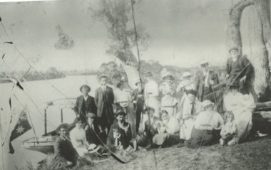 Lakes Entrance Historical Society
Photograph, Phillip Hancock, Howlett, Legg, Froud, Bly, Brideson, Bull, Bell, Thompson, Wilson Families on the bank of the Tambo River Gippsland Victoria, January 1915 c
James, Maud, Eva, May, Mabel Howlett, Fred, Marion, Alf, Gladys Legg, Carrie Froud, Jessie Bly, Lena Brideson, George Bull, Will Bell, Jim Thompson, Mr Wilson on the bank of the Tambo River Gippsland VictoriaBlack and white photograph showing small launch beside river and large Aboriginal canoe tree in background and eighteen adults and two children, genealogy, families -
Glenelg Shire Council Cultural Collection
Uniform - Glenelg Shire Council Name Badge - Karl Hatton, Glenelg Shire Council badge, 1995
In use by Council 1995-March 2006 Karl Hatton used to manage the Portland Arts Centre and is now part of the Portland CEMA groupGlenelg Shire Council badge bearing the name "Karl Hatton"Front: KARL HATTON Glenelg Shire Council Back: (no inscriptions) -
 Greensborough Historical Society
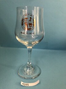
Glass, Shire of Eltham, Shire of Eltham commemorative glass, 1856-1994
Shire of Eltham commemorative glass. The Shire of Eltham existed from 1856 until 1994.Stemmed wine glass. Clear glass with gold embellishment."Shire of Eltham" and shire crest in gold.shire of eltham, commemorative glasses -
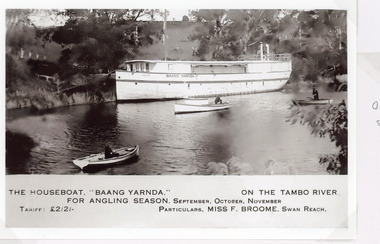 Lakes Entrance Historical Society
Postcard - Baang Yarnda, 1930c
The houseboat Baang Yarnda on the Tambo River for angling season, September October November. Tariff 2 pound 2 shillings Particulars Miss F Broome Swan ReachSepia toned postcard of the houseboat Baang Yarnda associated with Broome's Federal Hotel houseboat is moored in the Tambo River, people fishing from two small rowing boats and motor boat on river. Tambo Upper VictoriaThe Boat Baang Yarnda On the Tambo River. For Angling Season September, October, November Tariff Pounds 2/2/. Particulars:.Miss F Broome Swan Reachguesthouses, tourism, boats and boating -
Lakes Entrance Historical Society
Book, Wilson, John, The Official History of the Avon Shire 1840-1900, 1951
A history of the Shire of Avon, Gippsland, Victoriasettlers, government -
Greensborough Historical Society
Booklet - Calendar, Shire of Diamond Valley, Shire of Diamond Valley 1993 Calendar, 1993_
Copies of this calendar were distributed to households in the Shire of Diamond Valley. This 1993 Calendar features images of the Shire. Includes a Guide to services provided by Shire of Diamond Valley. The Shire of Diamond Valley was a Local Government Area located about 20 kilometres northeast of Melbourne. The Shire covered an area of 74.38 square kilometres and existed from 1964 until 1994.The annual calendar is a record of the activities and services in the former Shire of Diamond Valley.28 page calendar illustrated with photographs of the Shire, with 16 page liftout "Shire of Diamond Valley Resource Guide". shire of diamond valley, shire of diamond valley calendar -
 Eltham District Historical Society Inc
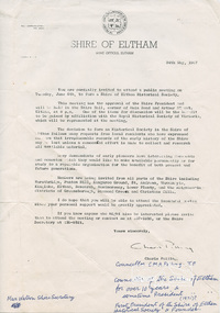
Letter, Shire of Eltham, Invitation by Councillor Charis Pelling to attend a public meeting on 6 June 1967 to form a Shire of Eltham Historical Society, 24 May 1967, 24/05/1967
Councillor Charis M.A. Pelling was a Councillor in excess of ten years and a former President of the Shire of Eltham. Cr Pelling was the founder of the Shire of Eltham Historical Society and the Society's first President.Public meeting for creation of the Shire of Eltham Historical Society, later Eltham District Historical Society subsequent to the cessation of the Shire of Eltham in late 1994. The society celebrates its 50th anniversary in 2017 and retains two founding members as current members.Letter typed on Shire of Eltham letterheadshire of eltham, shire of eltham historical society, society foundation, charis m.a. pelling -
 City of Greater Bendigo - Civic Collection
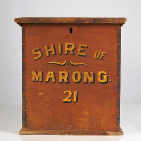
Functional object - Ballot Box, Shire of Marong, Shire of Marong 21, Unknown
The first local government authority for Marong was the Marong Road District (an early form of single-purpose local government), which was proclaimed on 19 August 1860. Its boundary was altered twice in 1862 and on 12 December 1864 it was re designated as a Shire. It absorbed Raywood Borough in 1915, and was proclaimed a Rural City in 1990. On 2 December 1994, with the creation of Greater Bendigo City Council, it was abolished through the amalgamation which took place between Bendigo City, Eaglehawk Borough, Huntly Shire, part of McIvor Shire, part of Metcalfe Shire and Strathfieldsaye Shire to form the City of Greater Bendigo. This box would have been used to collect votes during council elections.Wooden, painted, lidded box with hinged opening lid. Central slit in lid to insert ballot papers. Front face painted in black and gold paint. Hinged at back of box with lock on front. Front of box Shire of / Marong / 21shire of marong -
 City of Greater Bendigo - Civic Collection
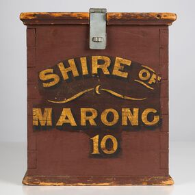
Functional object - Ballot Box, Shire of Marong, Shire of Marong 10, Unknown
The first local government authority for Marong was the Marong Road District (an early form of single-purpose local government), which was proclaimed on 19 August 1860. Its boundary was altered twice in 1862 and on 12 December 1864 it was re designated as a Shire. It absorbed Raywood Borough in 1915, and was proclaimed a Rural City in 1990. On 2 December 1994, with the creation of Greater Bendigo City Council, it was abolished through the amalgamation which took place between Bendigo City, Eaglehawk Borough, Huntly Shire, part of McIvor Shire, part of Metcalfe Shire and Strathfieldsaye Shire to form the City of Greater Bendigo. This box would have been used to collect votes during council elections.Wooden painted, lidded box with hinged opening lid. Central slit in lid to insert ballot papers. Front face painted in black and gold paint. Hinged at front of box with lock on back. Handle attached to the back.Front of box; Shire of / Marong / 21shire of marong -
 Lakes Entrance Historical Society
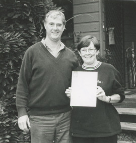
Photograph - Tambo Lodge winners of Tidy Town Award 1996 Kalimna West Victoria, Lakes Post Newspaper, 1/12/1996 12:00:00 AM
Terry and Sandra McMasters proprietors of Tambo Lodge winners of Tidy Town Award 1996 Kalimna West VictoriaBlack and white photograph of Terry and Sandra McMasters proprietors of Tambo Lodge winners of Tidy Town Award 1996 Kalimna West Victoriatourism, accommodation