Showing 106 items
matching topographic map
-
 Creswick Campus Historical Collection - University of Melbourne
Still Image, 1952
... of a topographical map marked State Aerial Survey. Stored in a brown... section of a topographical map marked State Aerial Survey. Stored ...Subject: King Lake . 6 brown envelopes marked Run 3, 4, 7, 7a, 8, 9 containing c. 80 prints. 1 section of a topographical map marked State Aerial Survey. Stored in a brown cardboard file box marked King Lake Run No.3 - 9. (x9). Photos commissioned by Forests Commission Victoria.Aerial Photographs -
 Department of Energy, Environment and Climate Action
Fire Finder
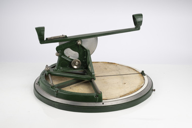
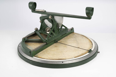
... Heavy cast iron circular object with a paper topographic... with a paper topographic map mounted on it. The metal dial and ruler ...Victoria once had well over one hundred fire lookouts and firetowers. Fire lookouts, or observation posts, were often just a clearing on a hill or a vantage point, whereas firetowers were definite structures. Many were established by the Forests Commission Victoria (FCV) in the 1920s, but the network was expanded rapidly in response to recommendations of the Stretton Royal Commission after the 1939 Black Friday bushfires. When a fire or smoke was spotted from the tower a bearing was taken with the alidade and radioed or telephoned into the district office. It was then cross referenced with bearings from other towers on a large wall map to give a "fix" on the fire location. Alidades and telescopes were used in the post war period but were replaced with a much simpler map table and reference string suspended from the centre of the tower cabin. This "Fire Finder" was used in Canadian fire towers to identify the location of wildfires. The unique design was first developed by the British Columbia Forest Service (BCFS) in the early 1950s. Close examination of the map indicates that this particular Fire Finder may have been once used at Bluejoint Mountain lookout in Granby Provincial Park. This Fire Finder was a gift to Barry (Rocky) Marsden from the British Columbia Forest Service in the late 1980s in recognition of the close relationships that had been forged with the staff at the Altona Workshops over many decades. Fire Finders were originally painted black but this one was repainted green after it arrived at Altona. The BC Forest Service had a large facility where they manufactured Fire Finders and many other items of equipment, but in the 1980s it was shut down. Heavy cast iron circular object with a paper topographic map mounted on it. The metal dial and ruler works similar to a compass. The sight tube is used to determine the bearing and elevation of the fire on the map. This Fire Finder also sometimes known as an Alidade. Its a different design from the Osborne Fire Finder widely used in North American fire lookouts from the 1920s. British Columbia Forest Service. Model 62A. Serial Number 6308.bushfire -
 Department of Energy, Environment and Climate Action
Fire Finder
... Heavy cast iron circular object with a paper topographic... with a paper topographic map mounted on it. The metal dial and ruler ...Victoria once had well over one hundred fire lookouts and firetowers. Fire lookouts, or observation posts, were often just a clearing on a hill or a vantage point, whereas firetowers were definite structures. Many were established by the Forests Commission Victoria (FCV) in the 1920s, but the network was expanded rapidly in response to recommendations of the Stretton Royal Commission after the 1939 Black Friday bushfires. When a fire or smoke was spotted from the tower a bearing was taken with the alidade and radioed or telephoned into the district office. It was then cross referenced with bearings from other towers on a large wall map to give a "fix" on the fire location. Alidades and telescopes were used in the post war period but were replaced with a much simpler map table and reference string suspended from the centre of the tower cabin. This "Fire Finder" was used in Canadian fire towers to identify the location of wildfires. The unique design was first developed by the British Columbia Forest Service (BCFS) in the early 1950s. Close examination of the map indicates that this particular Fire Finder may have been once used at Bluejoint Mountain lookout in Granby Provincial Park. This Fire Finder was a gift to Barry (Rocky) Marsden from the British Columbia Forest Service in the late 1980s in recognition of the close relationships that had been forged with the staff at the Altona Workshops over many decades. Fire Finders were originally painted black but this one was repainted green after it arrived at Altona. The BC Forest Service had a large facility where they manufactured Fire Finders and many other items of equipment, but in the 1980s it was shut down. Heavy cast iron circular object with a paper topographic map mounted on it. The metal dial and ruler works similar to a compass. The sight tube is used to determine the bearing and elevation of the fire on the map. This Fire Finder also sometimes known as an Alidade. Its a different design from the Osborne Fire Finder widely used in North American fire lookouts from the 1920s. British Columbia Forest Service. Model 62A. Serial Number 6308.bushfire -
Ringwood and District Historical Society
Map, Government Printer, Melbourne, Ringwood Zone Ordinance Survey Map, 1935
... - Commonwealth topographical map dated 1.8.35, scale 1:63,360... to cheesecloth, of Ringwood zone - Commonwealth topographical map dated ...Ordinance survey map glued to cheesecloth, of Ringwood zone - Commonwealth topographical map dated 1.8.35, scale 1:63,360. Information correct up to June 1922. "Ringwood 81" printed on the reverse side.; Envelope and note from donor of item, with return letter of appreciation from Ringwood & District Historical Society dated 20-May-2005. +Additional Keywords: Reid, Don -
 Surrey Hills Historical Society Collection
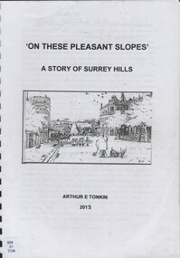
Book, On these pleasant slope's: a story of Surrey Hills, 2015
... , Jocelyn Hall. Includes: Topographical maps, first Elgar Survey..., Frank Bamford, Jocelyn Hall. Includes: Topographical maps, first ...Sourced via conversations with those interested in Surrey Hills History. Including Alan Holt, Jack McLean, Frank Bamford, Jocelyn Hall. Includes: Topographical maps, first Elgar Survey. First Wesleyan Church in Surrey Hills. Bibliography on P.50 (last numbered page) Provides a chronological history of Surrey Hills. Includes: First settlers, location, early land sales, commerce and trade.Provides a chronological history of Surrey Hills. Includes: First settlers, location, early land sales, commerce and trade.Back of Title page: To the Surrey Hills Historical / Arthur E. Tonkinfreehold investment and banking company, windsor park estate, (mr) dennis delany, mont albert village, surrey hills - history, royal hotel, surrey hills, humberstone's hotel, chatham state school, holy trinity church, lydswood, lugano, (mr) john butler maling, (mr) john hanlon knipe, mont albert primary school, (mr) james sneddon, (mr) arthur tonkin -
 Bendigo Military Museum
Photograph - 4th Field Survey Squadron – Operation MIZMAZE 92, Kimberley region, Western Australia, 1992
... the field completion of topographic maps and the acquisition... the field completion of topographic maps and the acquisition ...This is a set of 40 photographs taken in 1992 during 4th Field Survey Squadron’s deployment on Operation MIZMAZE 92 in the Kimberley region of Western Australia from the 13th of May to the 14th of July 1992. The area of operations was Wyndham, Halls Creek and Sandfire Flat. It was a two-part operation involving the field completion of topographic maps and the acquisition of mapping control by GPS field parties utilising Texas Instruments TI4100 Global Positioning System receivers. Survey parties conducted field checking of topographic maps and GPS control acquisition in Perentie 110 Series Survey variant FFR Land Rovers. Three Bell Kiowa LOH helicopters provided by 162 Recce Sqn supported field checking and limited deployment of GPS surveys parties. C-l30 Hercules from 36 Sqn supported deployment and extraction of personnel and equipment to and from from the AO. A Cessna 404 Titan Ambassador from Vee-H Aviation was used as the Wild RC10 camera platform for aerial photography acquisition.This is a set of 40 photographs taken in 1992 during 4th Field Survey Squadron’s deployment on Operation MIZMAZE 92 in the Kimberley region of Western Australia. The colour photographs are on 35mm negative film and are part of the Army Survey Regiment’s Collection. The photographs were scanned at 96 dpi. .1) - Photo, colour, 1992. CAPT Craig Hersant. .2) - Photo, colour, 1992. Unidentified officer/soldier. .3) & .4) - Photo, colour, 1992. Aboriginal rock art - Wandjina Gunduran, Donkey Creek. .5) - Photo, colour, 1992. Aboriginal rock art - Track Wandjinas, Donkey Creek. .6) & .7) - Photo, colour, 1992. CAPT Craig Hersant. .8) - Photo, colour, 1992. Kimberley region topography. CPL Glen Weatherell. .9) - Photo, colour, 1992. Unidentified personnel .10) - Photo, colour, 1992. Supermarket at unknown location. .11) to .13) - Photo, colour, 1992. Caravan park at unknown location. .14) - Photo, colour, 1992. Old bridge at Fitzroy Crosssing. .15) & .16) - Photo, colour, 1992. Survey party in Perentie 110 Series Land Rover. .17) & .18) - Photo, colour, 1992. Kimberley region topography. .19) - Photo, colour, 1992. Kimberley region topography. CPL Glen Weatherell. .20) - Photo, colour, 1992. Kimberley region topography, possibly the Bungle Bungles. .21) - Photo, colour, 1992. Kimberley region topography. SGT Frank Downie. .22) - Photo, colour, 1992. Kimberley region topography: the Bungle Bungles. .23) - Photo, colour, 1992. Kimberley region topography: the Bungle Bungles. .24) - Photo, colour, 1992. Kimberley region topography: the Bungle Bungles. SPR Neil Pedler. .25) & .26) - Photo, colour, 1992. Kimberley region topography: the Bungle Bungles. .27) - Photo, colour, 1992. Kimberley region topography. .28) - Photo, colour, 1992. Survey party with Perentie 110 Series Land Rover. .29) - Photo, colour, 1992. Kimberley region topography. .30) - Photo, colour, 1992. Survey party outside Perentie 110 Series Land Rover. .31) & .32) - Photo, colour, 1992. Survey party operating TI4100 GPS Receiver next to Perentie 110 Series Land Rover. SGT Eddie Jacobs. .33) & .34) - Photo, colour, 1992. Survey party operating TI4100 GPS Receiver next to Perentie 110 Series Land Rover. Unidentified surveyor. .35) - Photo, colour, 1992. Kimberley region topography. Hand water pump at well. .36) - Photo, colour, 1992. Survey party in Perentie 110 Series Land Rover. .37) - Photo, colour, 1992. Kimberley region topography. CPL Glen Weatherell. .38) - Photo, colour, 1992. Kimberley region topography viewed from Bell Kiowa LOH helicopter. .39) & .40) - Photo, colour, 1992. Unidentified surveyor field checking a preliminary map in a Bell Kiowa LOH helicopter..1P to .40P – There are no personnel identified. ‘1992 OP MIZMAZE annotated on negative sleeve.royal australian survey corps, rasvy, 4 fd svy sqn, op mizmaze 92 -
 Bendigo Military Museum
Poster - Map Production flow chart poster using Automap 2, Army Survey Regiment, Bendigo, 1982
... of a topographic data base, Future tactical applications and map products... of a topographic data base, Future tactical applications and map products ...This poster designed to be folded into a brochure describes the second phase of the computer assisted cartographic system to be used by the Royal Australian Survey Corps in the establishment of a topographic data base, Future tactical applications and map products using the data base are displayed. A topographic map of Series R631 1:100,000 Helenvale, Queensland printed on the reverse side that was produced by the Automap system using information from the topographic data base. This is the fifth edition of the poster.A multi colour poster of map production using the Automap 2 system. Poster shows a schematic and pictorial flow chart diagram of the stages of the map production process using the Automap 2 system. The poster was intended to be folded into a small brochure. A 1:100,000 Army Survey Map Series R631, 7966 Helenvale, Queensland Edition 2 is printed on the reverse side of the poster. The map is an example of one of the initial maps produced on the Automap 2 System at the Army Survey Regiment, Bendigo.royal australian survey corps, rasvy, fortuna, army survey regiment, army svy regt, asr, automap 2 -
University of Melbourne, Burnley Campus Archives
Map - Topographic Survey, Grampians, 1969
... Australia 1:100,000 Topographic Survey Map of the Grampians... Australia 1:100,000 Topographic Survey Map of the Grampians ...Australia 1:100,000 Topographic Survey Map of the Grampians, Victoria dated 1969. Sheet 7323 (Edition 1) Series R 652. Produced by the Royal Australian Survey Corps.grampians, royal australian survey corps, topographic survey -
University of Melbourne, Burnley Campus Archives
Map - Topographic Survey, Ararat, 1970
... Australia 1:100,000 Topographic Survey map of Ararat... Australia 1:100,000 Topographic Survey map of Ararat district ...Australia 1:100,000 Topographic Survey map of Ararat district, Victoria dated 1970. Sheet 7423 (Edition 1) Series R 652. Produced by the Royal Australian Survey Corps.royal australian survey corps, ararat area, stawell area -
 Wodonga & District Historical Society Inc
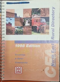
Book - North East Rural Directory 1998
... A spiral bound volume including colour topographic maps... topographic maps and illustrations of North East Victoria. The cover ...The CFA North East Rural Directory for Regions 23 and 24 was designed to assist fire brigades and other emergency services in responding to calls in the North East region of Victoria. Its purpose was to minimize response times to emergency situations by providing accurate and detailed information about all of the localities in the regions. District 23 is based at Wangaratta and Extends as far south as Woods Point. District 24 is centred in Wodonga and extends past Corryong to the New South Wales border following the Murray River. It also includes Falls Creek and Mount Hotham.A spiral bound volume including colour topographic maps and illustrations of North East Victoria. The cover features a collage of colour photo of North East Victoria including a CFA firefighter in a truck with members of his family beside it. The book also features a key map, explanation of map references and symbols, localities index. Alphabetical road indexes for Wodonga, Albury, Wangaratta and Benalla as well as township maps and alphabetical road indexes for smaller communities are included.The CFA North East Rural Directory for Regions 23 and 24 was designed to assist fire brigades and other emergency services in responding to calls in the North East region of Victoria. Its purpose was to minimize response times to emergency situations by providing accurate and detailed information about all of the localities in the regions. District 23 is based at Wangaratta and Extends as far south as Woods Point. District 24 is centred in Wodonga and extends past Corryong to the New South Wales border following the Murray River. It also includes Falls Creek and Mount Hotham.emergency management north east victoria, cfa region 24, cfa wodonga, cfa region 23 -
 Bendigo Military Museum
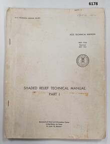
Manual - Shaded Relief Technical Manual - United States Air Force, Department of the Air Force, USA, May 1958
... on small scale topographical maps and RAAF Aeronauical Charts... on small scale topographical maps and RAAF Aeronauical Charts ...This manual describes how to hand create "Shaded Relief" or the appearance of hills. This manual was produced by the Aeronautical Chart Information Centre, United States Air Force, St Louis 18, Missouri. Shaded relief was produced by hand at the Army Survey Regiment in the 50's, 60's and 70's so that it could be shown on small scale topographical maps and RAAF Aeronauical Charts. Shaded relief continued to be produced by hand until the mid 1980's when it was replaced by digital production methods.Grey covered Manual, gloss paper, stapled together.royal australian survey corps, rasvy, fortuna, army survey regiment, army svy regt, asr -
 Nillumbik Shire Council
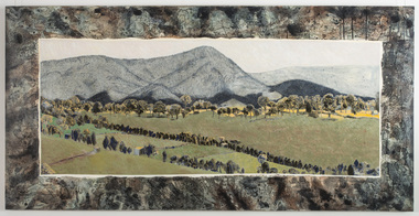
Mixed media: Liz NETTLETON, Liz Nettleton, Respite and Repose, 2010
... / Framing this view of the landscape is a pattern (topographical... (topographical maps of the Nillumbik area), which suggest the vast extent ...Nettleton creates an image of peace and tranquility after the violence felt from the 2009 Black Saturday bush fires / At the Arthurs Creek cemetery Nettleton found the grave of Reg Evans and Angela Brunton, friends who had perished in the fires / Nettleton sat on the edge of their joint grave and photographed their view / It was only after examining the photos more closely that she realized Mount Sugarloaf had burnt almost to the valley / Sugarloaf is always in an indigo haze. This work is by a local contemporary artist and encompasses themes dealing with the 2009 Black Saturday bushfires. Mixed media (acrylic paint, acrylic ink and indian ink) on board / Landscape painting of Mount Sugarloaf and green pastures after the 2009 Black Saturday bushfires / Mount Sugarloaf is depicted in an indigo haze in the background / A line of trees bathed in light border the mountain's edge / Lines of trees parallel to each other jut out diagonally in the foreground / Framing this view of the landscape is a pattern (topographical maps of the Nillumbik area), which suggest the vast extent of the devastated area of landscape. In black marker 'LIZ NETTLETON' + artist signature '2011' on back - middle right side nettleton, respite and repose, landscape, painting, mixed media, black saturday, mount sugarloaf -
 Bendigo Military Museum
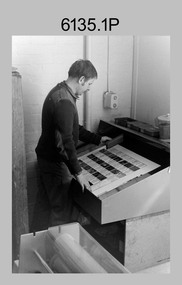
Photograph - Print Troop – Lithographic Squadron – Army Survey Regiment, Fortuna, Bendigo
... on the reverse side of a topographic map. This map was commonly referred... on the reverse side of a topographic map. This map was commonly referred ...This collection of 23 photos was most likely taken in Lithographic Squadron, Army Survey Regiment, Fortuna, Bendigo, in 1988. In photos .1P and .2P the technician is preparing a Chromalin map proof for supporting information that would be printed on the reverse side of a topographic map. This map was commonly referred to as a ‘snack’ map, with photos of edible indigenous plants and descriptions endemic to that region printed on the reverse side to assist soldiers living off the land in survival situations. The authoritative information was provided by Major Leslie James (Les) Hiddins aka ‘the Bush Tucker Man’ He is a retired Australian Army soldier and war veteran, who is best known for his love and knowledge of the Australian bush. See item 6190.6P for more information on the Chomalin proof production process. In the remaining photos, Print Troop’s technicians were most likely operating the Komoni, Planeta or Ultra-MAN-III offset printing presses, as well as working in the map despatch dock. Although these photos are not annotated most personnel are positively identified. This is a set of 23 photographs of Print Troop personnel and equipment from Lithographic Squadron at the Army Survey Regiment, Fortuna, Bendigo, 1988. The photographs were on 35mm negative film and were scanned at 96 dpi. They are part of the Army Survey Regiment’s Collection. .1) - Photo, black & white, 1988, Chromalin Proof laminating, Terry King. .2) - Photo, black & white, 1988, Chromalin Proof laminating, Terry King. .3) to .6) - Photo, black & white, 1988, Ultra-MAN-III Printing Press, Colin Yeats. .7) - Photo, black & white, 1988, Ultra-MAN-III Printing Press, L to R: Greg Rowe, SPR Mark ‘Dogs’ Doherty. .8) - Photo, black & white, 1988, Ultra-MAN-III Printing Press, SPR Mark ‘Dogs’ Doherty. .9) to .10) - Photo, black & white, 1988, Ultra-MAN-III Printing Press, John Bateman. .11) - Photo, black & white, 1988, Ultra-MAN-III Printing Press. .12) - Photo, black & white, 1988, Map laminator? L to R: SGT Dale Hudson, SGT Gary Kerr. .13) - Photo, black & white, 1988, Newkoni Komori Printing Press, Peter Hamilton. .14) to .17) - Photo, black & white, 1988, Original Heidelberg Printing Press, Peter Hamilton. .18) to .19) - Photo, black & white, 1988, Map Despatch area, SPR Steve Wright. .20) - Photo, black & white, 1988, Map Despatch area, L to R: unidentified, SGT Gary Kerr. .21) - Photo, black & white, 1988, Printing Presses - foreground: Ultra-MAN-III (x2), centre: Newkoni Komori and background: Planeta Polygraph. .22) - Photo, black & white, 1988, Ultra-MAN-III Printing Presses (x2). .23) - Photo, black & white, 1988, L to R: Daryl South, Mark McCulloch.No personnel are identifiedroyal australian survey corps, rasvy, army survey regiment, army svy regt, fortuna, asr, litho, printing -
 Bendigo Military Museum
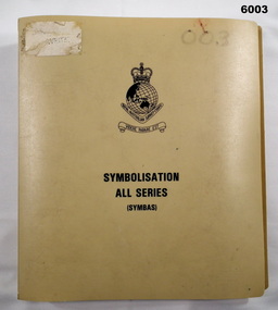
Manual - Symbolisation All Series (Symbas), Specification for maps produced by the Royal Australian Survey Corps, C 1988
... ) for the collection and compilation of topographic data; the basic...) for the collection and compilation of topographic data; the basic ...Symbas provides the specification (rules) for the collection and compilation of topographic data; the basic instructions for colour preparation and reproduction of topographical detail on maps produced by RASvyPlastic cover, book, beige, 7 chapters, metal clip bindingroyal australian survey corps, rasvy, fortuna, army survey regiment, army svy regt, asr, symbas, specification -
 Bendigo Military Museum
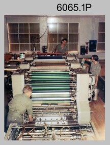
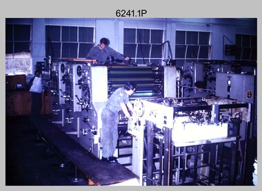
Photograph - Ultra-MAN-III Printing Presses operating at the Army Survey Regiment, c1970s to c1980s
... colour standard topographic map in two passes, rather than... colour standard topographic map in two passes, rather than ...These ten photographs of the Ultra-MAN-III Printing Presses were probably taken circa 1970s to 1980s in Lithographic Squadron at the Army Survey Regiment, Fortuna, Bendigo. Although most photos are not annotated except for photos .1, .3P, .6P; most personnel are positively identified. The two Ultra-MAN-III Printing Presses were made in Germany at a standard map size format and introduced in June 1962 as a two-colour offset press with improved safety features. With an upgrade to a third colour deck in 1968, productivity greatly improved as the two presses could print a five colour standard topographic map in two passes, rather than the three passes before their upgrade. They were replaced with a single Heidelberg Speedmaster 102 five colour Printing Press in 1990. c1970s to c1980s.This is a set of photographs of the Ultra-MAN-III Printing Press operational at the Army Survey Regiment, Bendigo c1970s to c1980s. The photographs were printed on photographic paper and are part of the Army Survey Regiment’s Collection. The photographs were scanned at 300 dpi. .1) - Photo, colour, c1970s, L to R: Morgan, Mulqueen, Cook, Lithographic Squadron .2) - Photo, black & white, c1980s, unidentified, Lithographic Squadron .3) - Photo, black & white, c1980s, Ken Slater, Lithographic Squadron .4) - Photo, black & white, c1980s, L to R: Kim Reynolds, Terry Winzar, Lithographic Squadron .5) - Photo, black & white, c1980s, Lithographic Squadron .6) - Photo, black & white, c1980s, L to R: Steve Egan, unidentified, Jim Cook, Lithographic Squadron .7) - Photo, black & white, c1980s, Kim Reynolds, Lithographic Squadron .8) - Photo, black & white, c1980s, Roy Hicks, Lithographic Squadron .9) - Photo, black & white, c1980s, Lithographic Squadron .10) - Photo, black & white, c1980s, Colin Yeats, Lithographic Squadron.1, .3P, .6P – personnel annotated 2P, .4P to .5P, .76P to .10P – no annotation royal australian survey corps, rasvy, army survey regiment, army svy regt, fortuna, asr, printing, litho -
 Bendigo Historical Society Inc.
Document - VICTORIA HILL - VISITOR PLANS FOR VICTORIA HILL
... and sign post shafts, engine beds, etc and prepare a topographical... and prepare a topographical map with these features on it. Second ...Handwritten carbon copy and typed copy of notes on 1st and 2nd stage plans for a tourist area on approx. 20 acres at Victoria Hill. First stage was to clean up the area, locate and sign post shafts, engine beds, etc and prepare a topographical map with these features on it. Second stage was to arrange for the purchase of typical miners homes and shops in the vicinity to be restored for inspection by visitors. Mining equipment to be placed in the area. Prepare brochures for sale. Set up a mining museum.Prepare an area near BCV 8 with direction finder to mining and general features, as this has the best natural ground level view in the City. Notes prepared by Albert Richardson.mine, gold, victoria hill, victoria hill, visitor plans for victoria hill, darrel mcclure, bendigo city council, bendigo historical society, central nell gwynne, caleb thomas, bcv 8, lazarus, old chum, new chum, victoria, repeater station (p. m. g.) -
 Bendigo Military Museum
Photograph - New Printing Press, Lithographic Squadron – Army Survey Regiment, Fortuna, Bendigo, 1990
... for a standard topographic map was printed in a single pass. The print... for a standard topographic map was printed in a single pass. The print ...This is a set of 30 photographs of contractors installing the Army Survey Regiment’s new Heidelberg Speedmaster 102 printing press in Lithographic Squadron’s purpose-built printing building at Fortuna, Bendigo in 1990. The computer-controlled five colour lithographic offset printing press provided the Royal Australian Survey Corps vastly improved printing capability, as the five colours for a standard topographic map was printed in a single pass. The print room was named Wayzgoose Hall after a medieval printing house festival. Wayzgoose Hall and the Speedmaster printing capability was commissioned by the Commander of the 3rd Military District BRIG P. Davies AM, ADC on Wednesday 27th June 1990. This occasion is covered in more detail in page 145 of Valerie Lovejoy’s book 'Mapmakers of Fortuna – A history of the Army Survey Regiment’ ISBN: 0-646-42120-4.This is a set of 30 photograph of the Heidelberg Speedmaster 102 Printing Press installation in Lithographic Squadron, Army Survey Regiment at Fortuna, Bendigo, 1990. The photographs were on 35mm colour negative film and were scanned at 96 dpi. They are part of the Army Survey Regiment’s Collection. No personnel are identified. Annotated with date on negative sleeve.royal australian survey corps, rasvy, army survey regiment, army svy regt, fortuna, asr, litho, printing -
 Bendigo Military Museum
Photograph - 4th Field Survey Squadron – Operation ARIGHT 93, Queensland, 1993
... checking of topographic maps covering Bamaga, Heathlands, Weipa... checking of topographic maps covering Bamaga, Heathlands, Weipa ...This is a set of 42 photographs taken during 4th Field Survey Squadron’s deployment on Operation ARIGHT 93 in North Queensland from the 30th of August to the 8th of October 1993. The Survey Field Completion area of operations was Weipa near the top end of the Cape York Peninsula. Survey parties conducted field checking of topographic maps covering Bamaga, Heathlands, Weipa, Lockhart River and Strathgordon in Perentie 110 Series Survey variant FFR Land Rovers. Hand-held Trimble and Magellan GPS receivers were used to assist with navigation and to position remote isolated features. Three Bell Kiowa LOH helicopters provided by 162 Recce Sqn supported field checking operations. Supplementary and Vital Asset Protection photography was taken by air camera operators in AAAvn Nomad aircraft from 173 Survl Sqn fitted with an RC10 aerial camera.This is a set of 42 photographs taken in 1993 durin8g 4th Field Survey Squadron’s deployment on Operation ARIGHT in North Queensland. The colour photographs are on 35mm negative film and are part of the Army Survey Regiment’s Collection. The photographs were scanned at 96 dpi. .1) - Photo, colour, 1993. Survey party in Perentie 110 Series Land Rover navigates through Cape York Peninsula sand hills. .2) - Photo, colour, 1993. Cape York Peninsula sand hills. .3) - Photo, colour, 1993. Cape York Peninsula Island. .4) - Photo, colour, 1993. Survey party in Perentie 110 Series Land Rover enters a Cape York Peninsula beach. .5) - Photo, colour, 1993. SPR Kim Baker takes a break on a Cape York Peninsula beach. .6) - Photo, colour, 1993. L to R: MAJ Andy Cordova (USA Exchange) from the Army Survey Regiment and unidentified civilians. .7) to .14) - Photo, colour, 1993. Cape York Peninsula topography. .15) - Photo, colour, 1993. Unidentified surveyor in Bell Kiowa LOH helicopter. .16) - Photo, colour, 1993. Bell Kiowa LOH helicopter circles base camp. .17) to .18) - Photo, colour, 1993. Cape York Peninsula topography. .19) - Photo, colour, 1993. Vehicle convoy taking a break. L to R: LT John Bath (Detachment OC), unidentified (x2), SPR Chris Pearse. .20) - Photo, colour, 1993. Vehicle convoy taking a break. .21) - Photo, colour, 1993. Vehicle convoy ready to go. SPR Chris Pearse. .22) - Photo, colour, 1993. Vehicle convoy on the move. .23) - Photo, colour, 1993. Cape York Peninsula topography. .24) - Photo, colour, 1993. Unidentified personnel. .25) - Photo, colour, 1993. SGT Neale ‘Tex’ Houston. .26) - Photo, colour, 1993. Ground below a Bell Kiowa LOH helicopter .27) - Photo, colour, 1993. L to R: SPR Mark Sinderberry and CPL Stuart Adrain in a Bell Kiowa LOH helicopter. .28) & .29) - Photo, colour, 1993. Ground below a Bell Kiowa LOH helicopter. .30) - Photo, colour, 1993. Base camp viewed from a Bell Kiowa LOH helicopter. .31) - Photo, colour, 1993. Cape York Peninsula topography in recovery after burn-off. .32) & .33) - Photo, colour, 1993. SPR Kim Baker contemplates crossing this bridge in his Land Rover. .34) - Photo, colour, 1993. SPR Kim Baker takes a break next to a billabong. .35) - Photo, colour, 1993. Survey party in Perentie 110 Series Land Rover crosses a creek. .36) - Photo, colour, 1993. Cape York Peninsula bush fire in distance. .37) - Photo, colour, 1993. Survey party in Perentie 110 Series Land Rover traverses a sand hill. .38) - Photo, colour, 1993. SPR Kim Baker. .39) - Photo, colour, 1993. Cape York Peninsula bush fire. .40) - Photo, colour, 1993. Cape York Peninsula topography. .41) & .42) - Photo, colour, 1993. Cape York Peninsula sand hills..1P to .42P – There are no personnel identified. ‘1993 OP ARIGHT’ annotated on negative sleeve.royal australian survey corps, rasvy, 4 fd svy sqn, op aright 93 -
 Bendigo Military Museum
Administrative record - Geodetic Survey and Topographical Mapping in Australia - Report by BP Lambert 1968, 1968
... been an urgent and increasing demand for topographic maps... been an urgent and increasing demand for topographic maps ...Australia is governed by a Federal Government and by six State Governments. National coordination of their respective geodetic survey and topographic mapping activities is effected on the advice of a National Mapping Council. Twenty years ago, at least 95% of Australia was poorly mapped and what maps existed were in need of revision. only a small area of the continent was covered by horizontal geodetic control and there was no scheme for a national levelling survey. Over the intervening period there has been an urgent and increasing demand for topographic maps varying from large scale contoured maps in support of specific engineering projects to rapid reconnaissance maps required for mineral prospecting in remote areas. Superimposed on this has been a defence requirement, specifically for military training areas, and generally for maps of the whole country. During the period much progress has been made. This paper reports on the progress from early colonial days through to the present time and finally hazards a prediction of future trends.Photocopy of 18-page typed report including diagrams, stapled top left-hand corner. Geodetic Survey and Topographic Mapping a Report by BP Lambert Director of National Mapping, Department of National Development, Canberra, Australia, 1968.royal australian survey corps, rasvy, fortuna, army survey regiment, army svy regt, asr, national mapping -
 Bendigo Military Museum
Pamphlet - An Introduction to Topographic Mapping, C 1991
... . The pamphlet comprehensively detailed the eight steps of topographic.... The pamphlet comprehensively detailed the eight steps of topographic ...This pamphlet was published by the Army Survey Regiment as an overview of the Royal Australian Survey Corps (RASvy), its role and unit structure circa 1991, prior to RASvy’s disbandment in 1996. The pamphlet comprehensively detailed the eight steps of topographic map production: Establish Survey Control, Aerial Photography, Aerotriangulation, Stereoplotting, Field Verification, Cartography, Printing and Storage/Map Distribution. Leading technologies used by RA Svy in 1991 included GPS control surveys, 5 colour printing on the Speedmaster offset press and bulk map packaging using the Map Handling Station (with guillotine). Digital map production was operating on the AUTOMAP 2 system, before the “Newheart” system upgrade two years later. Printed on the pamphlet cover was a portion of the plane tabled “four inches to a mile” map of Newcastle. This was compiled and surveyed in 1910 by LCPL A. Barrett, a member of the RAE Detachment, as part of the first major topographic mapping effort of Australia.This is a Royal Australian Survey Corp pamphlet with a historical map printed in colour on cardboard on both sides of the cover. There are 16 pages printed in colour on gloss paper, with photos, diagrams and descriptions. The pamphlet is bounded by two staples on its spine. Each of the 17 images were scanned at 300 dpi in JPEG (.jpg) format and stored on the attached 16 Gb USB memory stick. The images have been converted into MPEG-4 (.mp4) video format, 4Mb in size and runs for 2:16 minutes and is also stored on the memory stick.royal australian survey corps, rasvy, fortuna, army survey regiment, army svy regt, asr -
 Kiewa Valley Historical Society
Maps - Bogong x2, Tawonga, Omeo, Dargo, Victoria and others, 1. Bogong Alpine Area; 2. Bogong 8324; 3. Tawonga Topographical; 4. Omeo 8433; 5. Dargo 8323; 6. Victoria State
... . A topographical Map: 1:100,000 scale (1 cm to 1 KM). Map has a red..., Commonwealth of Australia 1981. A topographical Map: 1:100,000 scale (1 ...1. Bogong Alpine Area (outdoor Leisure Map. survey & Mapping Victoria, Government of Victoria, Edition 2, reprinted 1991 with an image of Mt. Feathertop on the front. Information for tourist in the Alpine National Park: Bogong Area. Including: recreational activities, history, weather and vegetation and a list of walks together with locality maps and photographs. The front cover has an image of Mt Feathertop against a blue sky with yellow writing 'Bogong Alpine Area', there is a yellow triangular block on the right hand top corner with black writing 'Outdoor Leisure Map. On the bottom edge is a block of yellow with black writing 'Survey & Mapping Victoria' and a light green map of Victoria with 'VICMSP' printed in white. 2. 8324 Bogong Victoria, Edition 1, Commonwealth of Australia 1981. A topographical Map: 1:100,000 scale (1 cm to 1 KM). Map has a red cover with white writing together with a white block and black writing and a map insert. 3. Tawonga Topographical Map - Forests Commission Victoria, / revised 5/9/77, DEG No. 68-G/399. A Tawonga 803 folded map in a beige colour with the back blank. 4. Omeo 8433 Victoria, Edition 1, Department of Natural Resources. The map has a red and white cover with black writing and a simple map of Australia at the bottom. 5. 8323 Dargo, Edition 1, Commonwealth of Australia. A red and white cover with a map insert. 6. Victoria State Map, Hema Maps, 2002. Hema Maps, State Map, colourful cover with a map of Australia and four tourism photographs. Scale 1: 850,000 An inscription handwritten in blue pen "Trappers Gap to Mitta Mitta 1" to 1 mile". There are some pen markings and notations of tracks.maps, bogong, omeo, tawonga, dargo, victoria, bogong alpine area -
 Bendigo Military Museum
Photograph - 4th Field Survey Squadron deployed on Operation NERIGHT, Queensland & Northern Territory, 1989
... . Part 1 was the field completion of topographic maps conducted.... Part 1 was the field completion of topographic maps conducted ...This is a set of 19 photographs taken in 1989 during 4th Field Survey Squadron’s deployment on Operation NERIGHT 89 in Queensland and the Northern Territory. It was a two-part operation in 1989 with work conducted in the areas of Camooweal and Weipa. Part 1 was the field completion of topographic maps conducted near Camooweal QLD, along the Barkley Highway on the border between NT and QLD, from the 12th of September to the 20th of October 1989. A Bell Kiowa LOH helicopter from 162 Recce Sqn supported topographic field completion. Operation NERIGHT 89 Part 2 was the acquisition of mapping control by GPS field parties utilising Texas Instruments TI4100 Global Positioning System receivers around Weipa on Cape York Peninsula from the 22nd of September to the 22nd of October 1989. Part 2 Two Bell UH-1H Iroquois helicopters from RAAF’s 35 Squadron were principally used to deploy GPS field parties. Identification photography of control points was taken by air camera operators in AAAvn Pilatus Porter aircraft from 173 Gen Spt Sqn fitted with an RC10 aerial camera. The two parts of the operation were conducted concurrently. This is a set of 19 photographs taken in 1989 during 4th Field Survey Squadron’s deployment on Operation Neright in Queensland & the Northern Territory. The colour photographs are on 35mm negative film and are part of the Army Survey Regiment’s Collection. The photographs were scanned at 96 dpi. .1) to .3) - Photo, colour, 1989. En-route to areas of survey operations. .4) to .5) - Photo, colour, 1989. Unidentified personnel relax next to river/waterhole. .6) - Photo, colour, 1989. Two Bell UH-1H Iroquois helicopters from RAAF’s 35 SQN utilised in the movement of GPS parties. .7) to .9) - Photo, colour, 1989. Unidentified soldier practices repelling from a UH1H Iroquois helicopter. .10) - Photo, colour, 1989. Inside the cockpit of a UH1H Iroquois helicopter. .11) - Photo, colour, 1989. Field Party camp with GPS equipment in foreground. Unidentified soldier prepares a meal. .12) - Photo, colour, 1989. GPS antenna plumbed over a survey ground mark. Witness post on left. .13) & .14) - Photo, colour, 1989. Unknown Cape York Peninsula beaches. .15) & .16) - Photo, colour, 1989. Dramatic fire next to base camp. .17) - Photo, colour, 1989. Aboriginal rock art at unknown location. .18) - Photo, colour, 1989. Aboriginal rock art at unknown location. L to R: unidentified, SPR Andrew Quin. .19) - Photo, colour, 1989. Aboriginal rock art at unknown location. LT Chris Topovsek..1P to .19P – There are no personnel identified. ‘1989 OP NERIGHT’ annotated on negative sleeve.royal australian survey corps, rasvy, 4 fd svy sqn, op neright 89 -
 Bendigo Military Museum
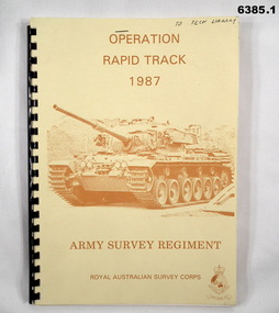
Administrative record - Army Survey Regiment - Operation Rapid Track 1987 Operation Report, Army Survey Regiment, Bendigo, 27 May 1987
... completion of four 1:50,000 topographical line maps and one Special 1... completion of four 1:50,000 topographical line maps and one Special 1 ...The Survey Operation Report deals with the cartographic completion of four 1:50,000 topographical line maps and one Special 1:50,000 map covering the Puckapunyal Military Training Area. The report covers in detail the digital stereo plotting, field completion (checking) and the cartographic completion including printing. The four 1:50.000 maps are 7823-1 PYALONG, 7824-2 COSTERFIELD, 7923-4 TALLAROOK and 7924-3 NAGAMBIE. Annex A lists personnel and dates involved and is attached as 6385.2. Annex B lists the members of the field completion parties.A4 sized buff coloured light cardboard covered report, plastic spiral binding. Front cover includes text, Survey Corps badge and light brown image of a Centurian tank. "To Tech Library", Page 2 has two small handwritten notes indicating that Phase 2 was the Field Completion Phaseroyal australian survey corps, rasvy, fortuna, army survey regiment, army svy regt, asr -
 Bendigo Military Museum
Photograph - Print Troop Equipment and Personnel, Lithographic Squadron – Army Survey Regiment, Fortuna, Bendigo, c1970s to 1980s
... topographic map in two passes, rather than the three passes before... topographic map in two passes, rather than the three passes before ...This collection of nine photos was most likely taken in Lithographic Squadron, Army Survey Regiment, Fortuna, Bendigo, c1970s to 1980s. The two Ultra-MAN-III Printing Presses were made in Germany at a standard map size format and introduced in June 1962 as a two-colour offset press with improved safety features. With an upgrade to a third colour deck in 1968, productivity greatly improved as the two presses could print a five-colour standard topographic map in two passes, rather than the three passes before their upgrade. They were replaced with a single Heidelberg Speedmaster 102 five colour Printing Press in 1990. There is more information on the Ultra-MAN-III, Printing Press on page 71 of Valerie Lovejoy’s book 'Mapmakers of Fortuna – A history of the Army Survey Regiment’ ISBN: 0-646-42120-4. For additional photos, refer to item 6065.10P for Ultra-MAN-III presses. The Krause Wohlenberg in photo .5P was a heavy-duty guillotine to trim bulk printed map stock in the c1970s and c1980s. See item 6069.6P for more information and photos of guillotine equipment. Densitometer readings as shown in photo .6P were essential to the quality control of film and printing processes, reductions in time taken and material wastage.This is a set of nine photographs of Print Troop personnel and equipment from Lithographic Squadron at the Army Survey Regiment, Fortuna, Bendigo, c1970s to 1980s. The photographs are on 35mm colour slides and were scanned at 96 dpi. They are part of the Army Survey Regiment’s Collection. .1) - Photo, colour, c1970s, Ultra-MAN-III Printing Presses, L to R: unidentified technician, Laurie Sutton, SGT Jim Cook, unidentified technician. .2) - Photo, colour, c1970s, Ultra-MAN-III Printing Presses, unidentified technicians (x2). George Mann Fast Five Quad Demi Printing Press in background. .3) - Photo, colour, c1970s, Ultra-MAN-III Printing Presses, unidentified technicians (x2), George Austen in background and George Mann Fast Five Quad Demi Printing Press next to back wall. .4) - Photo, colour, c1970s, Ultra-MAN-III Printing Press, unidentified technicians (x2) operating George Mann Fast Five Quad Demi Printing Press in background. .5) - Photo, colour, c1970s, Krause Wohlenberg heavy-duty paper guillotine, unidentified technician. .6) - Photo, colour, c1970s, Densitometer reading taken by unidentified technician. .7) - Photo, colour, c1980s, Ultra-MAN-III Printing Presses, L to R: Janet Murray, Lance Strudwick, Terry Winzar, Komori Newkoni and Planeta Polygraph Printing Press in background. .8) to .9) - Photo, colour, c1980s, Ultra-MAN-III Printing Presses, Janet Murray, Komori Newkoni and Planeta Polygraph Printing Presses in background..1P to .9P - There are no annotations stored with the 35mm slides.royal australian survey corps, rasvy, army survey regiment, army svy regt, fortuna, asr, printing, litho -
 Bendigo Military Museum
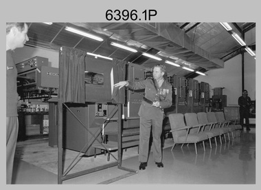
Photograph - Wayzgoose Hall and Speedmaster Printing Press Commissioning, Army Survey Regiment, Fortuna Villa, Bendigo, 1990
... printed topographic map – 8123 4 Mansfield 1:50 000. .3) - Photo... printed topographic map – 8123 4 Mansfield 1:50 000. .3) - Photo ...The first photograph was probably taken at a media event announcing the introduction of the Heidelberg Speedmaster printing press in late 1990. LTCOL Rene van den Tol was the CO of the Army Survey Regiment from 1989 to 1991. Partly obscured behind the CO was Mr Bruce Reid, who was the newly elected federal member for Bendigo. The media event was held in Wayzgoose Hall, Lithographic Squadron’s new purpose-built building constructed to house the Speedmaster printing press. This occasion is covered in more detail in page 143 of Valerie Lovejoy’s book 'Mapmakers of Fortuna – A history of the Army Survey Regiment’ ISBN: 0-646-42120-4. Refer to Item 6291.6P for more photos of the Open Day.This set of three photographs were taken at the commissioning ceremony of Wayzgoose Hall, the Army Survey Regiment’s new printing building and the Heidelberg Speedmaster Printing Press, at Fortuna Bendigo on Wednesday 27th June 1990. The black & white photographs were printed on photographic paper and are part of the Army Survey Regiment’s Collection. The photographs were scanned at 300 dpi. .1) - Photo, black & white, 1990. Commissioning Ceremony L to R: CO LTCOL Rene van den Tol, Commander 3rd Military District BRIG P. Davies AM ADC, WO2 Jeff Willey in background. .2) - Photo, black & white, 1990. L to R: CO LTCOL Rene van den Tol, Commander 3rd Military District BRIG P. Davies AM ADC with first printed topographic map – 8123 4 Mansfield 1:50 000. .3) - Photo, black & white, 1990. L to R: SGT Gary Kerr in background, Seligson Claire Printing Press Suppliers - Richard Rasmussen and Oliver Holliwell, Bob Martin, Director of Survey COL Don Swiney MBE, RA Svy COL CMDT COL John Hillier, Commander 3rd Military District BRIG P. Davies AM ADC, Bruce Reid Bendigo MHR..1P to .3P – Annotated on back of photos ‘Opening New Print Room BRIG Davies 27 Jun 90’. Personnel and civilians are identified.royal australian survey corps, rasvy, army survey regiment, army svy regt, fortuna, asr, litho -
 Bendigo Military Museum
Photograph - Print Troop Equipment, Lithographic Squadron – Army Survey Regiment, Fortuna, Bendigo, c1990s
... printing capability, as the five colours for a standard topographic... printing capability, as the five colours for a standard topographic ...This is a set of 25 photograph of Print Troop Equipment in Lithographic Squadron, Army Survey Regiment at Fortuna, Bendigo, 1990. Photo .1P features the new Howson Algraphy Autoneg printing plate processor. It improved quality control and efficiency and allowed the conversion of printing plates for positive or negative use. The Heidelberg Speedmaster 102 shown in photos .2P to .4P was a computer-controlled five colour lithographic offset printing press. It provided the Royal Australian Survey Corps a vastly improved printing capability, as the five colours for a standard topographic map was printed in a single pass. The print room housing the Speedmaster printing press was named Wayzgoose Hall after a medieval printing house festival. Wayzgoose Hall and the Speedmaster printing capability was commissioned by the Commander of the 3rd Military District BRIG P. Davies AM, ADC on Wednesday 27th June 1990. This occasion is covered in more detail in page 145 of Valerie Lovejoy’s book 'Mapmakers of Fortuna – A history of the Army Survey Regiment’ ISBN: 0-646-42120-4. For additional photos, refer to item 6062.4P for more photos of the Heidelberg Speedmaster printing press. The Print Room’s Map Assessment and Colour Evaluation Stations in photos .5P to .12P provided the Printer Technician suitable viewing environments to perform quality assessments of map samples. See item 6151.34P for more information and photos of technicians using the equipment. The Print Room’s Map Handling Station in photo .15P to .20P provided ergonomic benefits to the Printer Technician and improved despatching productivity. See Item 6070.9P for more information and photos. The Wohlenberg MCS-2 guillotine seen in photos .21P & .22P was a heavy-duty guillotine integrated component of the Map Handling Station, to trim bulk printed map stock. See item 6069.6P for more information and photos of earlier types of guillotine equipment. This is a set of 25 photograph of Print Troop Equipment in Lithographic Squadron, Army Survey Regiment at Fortuna, Bendigo, 1990. The photographs are on 35mm colour slides and were scanned at 96 dpi. They are part of the Army Survey Regiment’s Collection. .1) - Photo, colour, c1990s, Howson Algraphy Autoneg printing plate processor .2) to .4) - Photo, colour, 1990. Heidelberg Speedmaster 102 computer-controlled five colour lithographic offset printing press .3) to .10) - Photo, colour, c1990s, Heidelberg Speedmaster CPC 1-04 control unit. .11) to .12) - Photo, colour, c1990s, Map Colour Evaluation Work Station. .13) to .14) - Photo, colour, c1990s, Linear printing plate registration punch. .15) to .20) - Photo, colour, c1990s, Print Room’s Map Handling Station. .21) to .22) - Photo, colour, c1990s, Wohlenberg MCS-2 guillotine. .23) - Photo, colour, c1990s, Print Room Power supply equipment. .24) to .25P - Photo, colour, c1990s, Print Room Crown Fork Lift..1P to .25P - There are no annotations stored with the 35mm slides.royal australian survey corps, rasvy, army survey regiment, army svy regt, fortuna, asr, printing, litho -
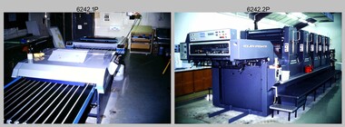
 Bendigo Military Museum
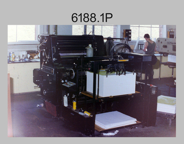
Photograph - Lithographic Squadron’s Printing Presses at the Army Survey Regiment, Fortuna Bendigo, c1980s
... -colour standard topographic map in two rather than the three...-colour standard topographic map in two rather than the three ...This is a set of 19 photographs of the four types of printing presses in Lithographic Squadron at the Army Survey Regiment, Bendigo in the late 1980s. The Original Heidelberg Printing Press features in photograph 6188.1P. It was a robust and well-made single colour lithographic offset press that was in service at the Army Svy Regt for decades. Its primary use was for initial training and rapid response tasks, such as single pass overprints over existing print stock. See item 6062.4P for more information and photographs of the Heidelberg press. The Komori Newkoni Printing Press features in photographs 6188.2P to 6188.6P. It was a four-colour offset press in service at the Army Svy Regt from 1975 to the late 1980s. Intended improvements to productivity were not realised as it was unreliable, was very cramped between decks and there were safety concerns for the operators. See item 6063.5P for more information and photographs of the Komori press. The Planeta Polygraph Printing Press features in photographs 6188.7P to 6188.11P. It was a two-colour offset press in service from 1976 to 1994 and was mainly used to print Naval and medium format RAAF charts. It was more reliable than the Komori Printing Press however procurement was difficult when spare parts were required. It was replaced by the larger format Roland 8047B four colour Printing Press. See item 6064.9P for more information and photographs of the Planeta press. The Ultra-MAN-III Printing Presses feature in photograph 6188.12P to 6188.19P. The two presses were a standard map size format and were introduced in June 1962 as two-colour offset presses with improved safety features. Productivity greatly improved with the addition of a third colour deck in 1968, as the two presses could print a five-colour standard topographic map in two rather than the three passes before the upgrade. See item 6065.10P for more information and photographs of the Ultra-MAN-III presses. They were replaced with a single Heidelberg Speedmaster 102 five colour Printing Press in 1990. See item 6136.30P for more information and photographs of the Speedmaster press.This is a set of 19 photographs of the four types of printing presses in Lithographic Squadron at the Army Survey Regiment, Bendigo in the late 1980s. The photographs were on 35mm negative film and scanned at 96 dpi. They are part of the Army Survey Regiment’s Collection. .1) - Photo, colour, c1980s, Original Heidelberg Printing Press, Print technician Jeff Willey on right, Lithographic Squadron. .2) to .6) - Photo, colour, c1980s, Komori Newkoni Printing Press, Lithographic Squadron. .7) to .11) - Photo, colour, c1980s, Planeta Polygraph Printing Press, Lithographic Squadron. .12) to .19) - Photo, colour, c1980s, Ultra-MAN-III Printing Presses, Lithographic Squadron.There are no annotations.royal australian survey corps, rasvy, army survey regiment, army svy regt, fortuna, asr, litho -
 Bendigo Military Museum
Photograph - Detachment - Army Survey Regiment, Bonegilla, Victoria, c1973
... topographic maps ranging in scale from 1:25,000 to 1: 250,000 scale... topographic maps ranging in scale from 1:25,000 to 1: 250,000 scale ...This is a set of six photographs of personnel from the Detachment - Army Survey Regiment taken in front of its main map production building at Bonegilla, Victoria in c1973. This cartographic map production sub-unit of the Army Survey Regiment operated in buildings owned by the School of Military Survey from 17th of June 1970 to the 30th of September 1985. A total of 800 topographic maps ranging in scale from 1:25,000 to 1: 250,000 scale were completed. A major focus of production in the 1970s was the cartographic completion of the Papua-New Guinea 1:100,000 map series and the Flexiflow quality control system was developed as a tool to coordinate production. The Flexiflow system comprised a series of job plans and charts linked to a task allocation to resource magnetic planning board. Using critical path analysis and task prioritisation, complex job planning was efficiently scheduled, and re-prioritisations readily made. Reproduction requirements were effectively coordinated by way of weekly courier to the Army Survey Regiment at Bendigo. Supervisors and technicians fully embraced the system as they could understand their role, others around them and the positive production achievements. WO1 Bill Boyd (who does not appear in this photograph) was the technical warrant officer for 11 years at the Detachment was awarded the OAM, the Order of Australia Medal for leading the development and the implementation of the Flexiflow system. By mid-1982, production of maps at these scales was undertaken digitally on Bendigo’s AUTOMAP 2 system and the Detachment reverted to production of small-scale large format RAAF aeronautical charts. Detachment personnel managed to produce 18 charts in the following two years, which was an impressive achievement for the staff, given major differences in format, specification and scales. Development of digital production of aeronautical charts in 1984-85 led to gradual reduction in production output and contracting out production was instigated to meet the shortfall and as a consequence the Detachment closed in September 1985. See pages 177 to 180 of Valerie Lovejoy’s book 'Mapmakers of Fortuna – A history of the Army Survey Regiment’ ISBN: 0-646-42120-4. for more information on the history of the Detachment at Bonegilla.This is a set of six photographs of the Detachment - Army Survey Regiment taken in front of the main map production building at Bonegilla, Victoria in c1973. The photographs were printed on photographic paper and are part of the Army Survey Regiment’s Collection. The photographic print and proofs were scanned at 600 dpi. .1) to .3) - Photo, black & white c1973. Back Row L to R: Peter Simpson, Chris Edwards, unidentified (x2), Colin Harden, Rowan Gillies, Bob Rowley OAM, Steve Hansen, Stu Thaxter. Centre Row L to R: Kevin Boehm, Dennis McCarthy, Peter Cross, unidentified, Brian Ryan, unidentified, Ian Marner, unidentified, Phil Smalley. Front Row L to R: Geoff Haynes, Bruce Wetzig, Dave Thompson, unidentified, OC Bob Roche, Ike Lever, John McCulloch, Dick Barwald, unidentified. .4) - Photo, black & white c1973. Back Row L to R: Peter Simpson, Chris Edwards, unidentified (x2), Colin Harden, Rowan Gillies, Bob Rowley OAM, Steve Hansen, Stu Thaxter. Centre Row L to R: Kevin Boehm, Dennis McCarthy, Peter Cross, unidentified, Brian Ryan, unidentified, Ian Marner, Phil Smalley, unidentified, Dick Barwald. Front Row L to R: Geoff Haynes, Bruce Wetzig, Dave Thompson, unidentified, OC Bob Roche, Ike Lever, John McCulloch, unidentified (x2). .5) - Photo, black & white c1973. Back Row L to R: Geoff Haynes, unidentified, John McCulloch, Bruce Wetzig. Front Row L to R: Dave Thompson, Ike Lever, unidentified. .6) - Photo, black & white c1973. L to R: OC Bob Roche, unidentified.There are no personnel annotated.royal australian survey corps, rasvy, army survey regiment, detachment - army survey regiment, army svy regt, asr -
 Bendigo Military Museum
Letter - Army Survey Regiment - Letter of request for additional computer disk space for Automap 2, Army Survey Regiment, 19 Feb 1987
... , RAAF Chart symbol Placement, ASTIS - Army Survey - Topographic..., RAAF Chart symbol Placement, ASTIS - Army Survey - Topographic ...Automap 2 was the Army Survey Regiment's computerized Mapping system. This letter is a request for an additional 700 Mb of computer disk space for the Automap 2 System because of newly developed applications. Those applications were: Analytical Hill shading, Digital Terrain Modelling, Mask and stipple Production, RAAF Chart symbol Placement, ASTIS - Army Survey - Topographic Information System, and, Map Catalog Production.Two page letter, foolscap size, Stapled top left corner"A Spurling, Computer Operations Manager for CO"royal australian survey corps, rasvy, fortuna, army survey regiment, army svy regt, asr -
 Bendigo Military Museum
Photograph - AITA Award - RA Svy’s AUTOMAP 2 Computer Based Map Production System, Army Survey Regiment, Fortuna, Bendigo, 1984
... topographical maps have a scale of 1:50,000 or 1:100,000 although... topographical maps have a scale of 1:50,000 or 1:100,000 although ...This collection of three photos of the Australian information Technology Award (AITA) won by the Royal Australian Survey Corps (RA Svy) AUTOMAP 2 computer-based map production system, was taken in 1984 at the Army Survey Regiment, Fortuna, Bendigo. The following article appeared in the ARMY Newspaper on Thursday 21st February 1985. ‘In computerised map production. Survey soldiers lead the world. BENDIGO: Army surveyors have been put on the map as world leaders in computerised map production following the Australian information Technology Awards. RA Svy won the Computer Assisted Draughting – Mapping section for its Automap II System which has created considerable interest among overseas defence experts. The award for the digital mapping system was accepted by OC Air Survey Sqn, MAJ Rob John, who said it was a great morale-booster for the soldiers of the Bonegilla (sic)* -based Army Survey Regiment. "Setting up a state-of-the-art system like Automap II. is an enormous task, " he said. "We started in August 1983 and it's only recently that we have achieved production results. "We were all very pleased to have our efforts recognised in this way. “Of course, credit must also go to the Intergraph Corporation for manufacturing the system and carrying out most of the development." RA Svy is responsible for producing all of Australia's maps used for defence purposes. Its topographical maps have a scale of 1:50,000 or 1:100,000 although Automap II has the capability of producing smaller scale maps - down to 1: 2,000,000. Automap II consists of three computers and three sub-systems: input, raster scanning, and graphic edit. The input sub-system has eight stereo plotters, two interactive graphic workstations and a system manager workstation. The stereo plotters use superimposition optics to digitise features from aerial photographs. It incorporates a voice recognition system so the operator can simply say "House", "Windmill", etc; and the relevant feature will be incorporated in the digital picture. Individual map separations are scanned and converted by the raster scanning sub-system to a digital raster image. This image is then converted to a graphics file in Intergraph format.’ *Note – the Army Survey Regiment was located in Bendigo, not Bonegilla as incorrectly stated in the article. The article appears on Page 137 of Valerie Lovejoy’s book 'Mapmakers of Fortuna – A history of the Army Survey Regiment’ ISBN: 0-646-42120-4. Additional history of the AUTOMAP 2 system with historic photographs is covered in pages 119, 137-143 and 157 of the 'Mapmakers of Fortuna’ book. See item 6223.23P for additional history and photographs of the AUTOMAP 2 system.This collection of three photos of the Australian information Technology Award (AITA) won by the Royal Australian Survey Corps (RA Svy)’s AUTOMAP 2 computer-based map production system, was taken in 1984 at the Army Survey Regiment, Fortuna, Bendigo. The photographs are printed on photographic paper and are part of the Army Survey Regiment’s Collection. The black and white photographs were scanned at 300 dpi. .1) - Photo, black & white, 1984, AITA Award sitting between the dual screens of an AUTOMAP 2 Graphic Edit Workstation. .2) - Photo, black & white, 1984, MAJ Job Johns (centre) and two of Intergraph Corporation IT engineers proudly hold the AITA Award next to an AUTOMAP 2 Graphic Edit Workstation. .3) - Photo, black & white, 1984, The AITA Award displayed on a pedestal in the Army Survey Regiment Officers Mess. .1P to .3P –No personnel are identified. ‘AITI Award to AUTOMAP II 1984’ annotated on cover sleeve. royal australian survey corps, rasvy, army survey regiment, army svy regt, fortuna