Showing 199 items
matching vehicle track
-
 8th/13th Victorian Mounted Rifles Regimental Collection
Photograph
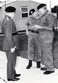
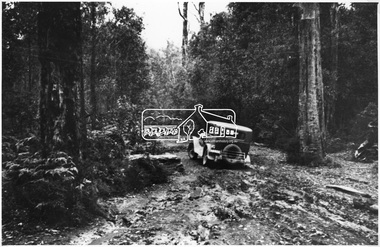
... The 8/13th Victorian Mounted Rifles held its tracked... melbourne The 8/13th Victorian Mounted Rifles held its tracked ...The 8/13th Victorian Mounted Rifles held its tracked Armoured vehicle training program camps at Puckapunyal. The regiment was raised as part of the Royal Australian Armoured Corps on 1 May 1948 with Headquarters in Melbourne and squadrons in Sale, Benalla/Wangaratta and Albury. In 1955 Regimental Headquarters moved to Wangaratta and a second squadron was located at Albury. The Sale squadron transferred to 4th/19th Prince of Wales’s Light Horse. In 1977 8/13 VMR Regiment was reduced to an independent squadron A Squadron 8th/13th Victorian Mounted Rifles and in 1991 was linked with 4th/19th Prince of Wales’s Light Horse forming the VMR Squadron of that regiment.Black and white photograph of three officers at 8/13 Victorian Mounted Rifles Annual Caomp at Puckapunyal 1974.. They are Colonel LG Coleman ( Honorary Colonel ). Lieutenant Colonel J Neale ( Commanding Officer and Major ( Ret'd) N. whitehead MC. -
 Kew Historical Society Inc
Photograph - Filling in the Outer Circle Railway cutting at East Kew, 1939
... ) showing workers and vehicles filling in the tracks of the former... and vehicles filling in the tracks of the former Outer Circle railway ...W.D. Vaughan (Kew's Civic Century, 1960, pp.195-6) quotes Council Minutes of 1938 and 1939 to record that: "After protracted negotiations between the Council, the Railways Department and the Tramways Board agreement was reached in June, 1938, for the filling of the railway cutting at the Harp Junction and shifting tram tracks to the High Street alignment ... The Outer Circle railway land from Princess Street to Park Crescent was purchased by the Kew Council in October, 1939, for 2,750 [pounds]. The land from Park Crescent to High Street was leased for 1 [pound] per annum. Considerable work was done in levelling the embankments to the original surface level."Important and rare photograph of the period, showing major works by Kew Council in Kew East working on a significant piece of urban infrastructure.Small, original black and white positive (photograph) showing workers and vehicles filling in the tracks of the former Outer Circle railway at East Kew. In the background is the metal bridge with brick piers, adjacent to the Harp Junction. The bridge crossed the cutting, linking the two parts of High Street. Behind the tip truck, painted on the side with the name 'Fowler Quarries' [located Keilor Road, North Essendon], one can see shops [including T.G. Garroway, Cash Grocer] in High Street. What appears to be the City of Kew Steamroller is immediately in front of the bridge. A group of passers-by watch from the bridge and from the road. Annotation in pencil on verso: "Filling in Outer Circle line at High St East Kew prior to straightening High St. (c. Feb 1930?)outer circle railway, railway cuttings, harp junction, high street -- kew east -
 Phillip Island and District Historical Society Inc.
Photograph, Harry Bradley - Phillip Island Identity
... -03: Original House of Bradleys, opposite Race Track?? Ford... Track?? Ford Vehicle. Now Beachcomber Estate 491-04: Harry ...Harry Bradley was a local Identity. Born in Yorkshire, England, 8/4/1916. Joined the Australian Army 19/5/1941 living in Cowes Phillip Island Victoria.Historical491-01: Harry Bradley an Australia Army Portrait - WWII 491-02: Harry Bradley & Ted Walton, very close fishing mates 491-03: Original House of Bradleys, opposite Race Track?? Ford Vehicle. Now Beachcomber Estate 491-04: Harry Bradley working on the 1st Phillip Island Bridge 491-05: Harry Bradley's parents - Father - Edwin and Mother who was killed by a bull 491-06: Harry Bradley - Equal 1st Competition at the Lang Lang Gun Club 491-07: Elsford Guest House - Post Card 491-08: Map of Phillip Island - Post Card Also DVD supplied with 491-01 to 06 on it.As Above with Harry's details listed on 491-01harry bradley, ted walton, edwin bradley, lang lang gun club, elsford guest house, phillip island map -
 Phillip Island and District Historical Society Inc.
Photograph - Post Cards, A. J. Murray et al, c 1940
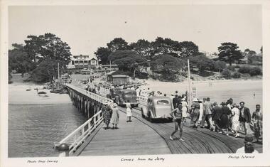
... Pier with vehicles and pedestrians. Rail tracks on pier. Isle... with vehicles and pedestrians. Rail tracks on pier. Isle of Wight Hotel ...A collection of 6 postcards and 1 photograph taken around Phillip Island. Donated by Julie Barnett.Photograph 228-01. Black & White photograph of the Cowes Pier with vehicles and pedestrians. Rail tracks on pier. Isle of Wight Hotel in background. Sheds at end. Photograph 228-02. Black & White aerial photograph of "Broadwater" Guesthouse, Cowes. Photograph 228-03. Black & White photograph of Cowes Pier with Steamer coming in. Shed at end of Jetty and Cenotaph in the foreground. Looking north. Photograph 228-04. Black & White photograph of a Koala and her young. Photograph 228-05. Black & White photograph looking over the Cowes shoreline near Lover's Walk. Photograph 228-06. Black & White photograph of a group of penguins coming home at dusk at the "Penguin Parade". Photograph 228-07. Black & White photograph of Bert West holding a Shearwater (Mutton Bird) with it's wings outstretched.Photo 01. "Photo Shop Series". "Cowes from the Jetty". Photo 02. Aerial view of "Broadwater" Cowes, Phillip Island. No. 146 Photo 03. "Photo Shop Series". The Jetty. Cowes. Photo 04. "Photo Shop Series". "Koala Bear". Phillip Island Photo 05. "The Rose Series P3416". "Near the Lovers' Walk, Cowes, Phillip Is., Vic. Photo 06. "Penguins, Phillip Island." No. 82. Valentines Series. Photo 07. On Back: Mr West with Mutton bird at Phillip Island.wildlife - koalas, wildlife - penguins, penguin parade, bert west, wildlife - mutton birds, mutton birds, shearwaters, cowes pier phillip island, cowes jetty, lover's walk cowes, broadwater guesthouse cowes phillip island, guesthouses cowes phillip island, julie barnett -
 Falls Creek Historical Society
Photograph - Axtrack oversnow vehicle Falls Creek Hotel
... by trade. He built this small twin track vehicle for Ivan Spargo... by trade. He built this small twin track vehicle for Ivan Spargo ...This vehicle, an Axtrack is located outside the Falls Creek Museum. It was built by Axel Andre who worked in Falls Creek as a mechanic for several years in the early 1970s. Axel was an engineer by trade. He built this small twin track vehicle for Ivan Spargo at the Falls Creek Hotel and then progressed to building bigger and better models. This included one for Ziggy Doer at Koki and Neville Mashford at Snowland purchased two of them. Some of these machines were also exported to America. Axel Andre later established a company Axtrack Engineering in Melbourne. There are still three of these Axtrack vehicles on the hill at Falls Creek in 2024. The vehicles were used for commercial purposes such as transporting supplies and staff around the mountain. The Spargo family from the Falls Creek Hotel used this vehicle for oversnow transport and it advertised Harvey Wallbanger Happy Hour. Ivan and Joy Spargo relocated from Melbourne to Falls Creek in 1965. They purchased a piece of leasehold land and built Spargo Lodge. This was a dorm style chalet built to accommodate large groups and families. Their son Rob Spargo met his future wife Blanche in 1967 when she was on holiday in Falls Creek. They married and purchased the site where the Falls Creek Hotel is today. The steep gradient of the site was a challenge to build on but was the best location available in the village. In 1970 Rob’s sister Leonie and her husband Glenn joined the business, and they started operating the hotel in 1972. The family played a critical role in the growth of the Falls Creek community and were involved in the foundation of Falls Creek Primary School and Falls Creek Search & Rescue. Rob was also involved in the start-up of Ski Victoria and has served as a member of the Chamber and Resort Management Board. Rob’s eldest daughter Lisa competed with the Australian Ski Team from 1985 to 1989 and has worked as a ski instructor in Australia, Austria & Colorado. In 2010 Lisa and her husband Damien Allport joined the family business and her parents retired to Tawonga South in 2014. Their children are now the fourth generation of the Spargo family living at Falls Creek enjoying the alpine lifestyle and providing outstanding hospitality. The 40 year tradition of the Harvey Wallbanger Happy Hour held on Tuesdays and Thursdays continues at Falls Creek Hotel in 2024.This item is significant because it depicts an important form of transport at Falls Creek, VictoriaA coloured photo of a black Axtrack oversnow vehicle decorated with red and yellow advertising.FALLS CREEK HOTEL APRES ENTERTAINMENT HARVEY HOUR TUES & THURS 3.30 PM LIVE ENTERTAINMENTaxtrack, oversnow vehicles, falls creek transport, spargo lodge, falls creek hotel -
 Melbourne Tram Museum
Photograph - Black & White Photograph/s, c1926
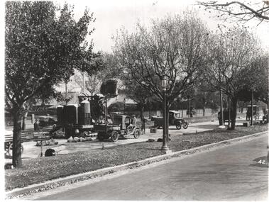
... Construction Ltd, with a concrete mixer tracked vehicle and two... by the Foundation Construction Ltd, with a concrete mixer tracked vehicle ...Black and white photograph of the construction of the tram track in St Kilda Road, during 1925 or 1926 by the Foundation Construction Ltd, with a concrete mixer tracked vehicle and two aggregate or crushed rock trucks. Photo from the Collection of the Department of Infrastructure now with the Public Records Office - image number H514. Note: this photo is now out of copyright and was not an original VR photograph, but one copied from another source and collected as their Heritage series. See Image 3674i2 and 3674i3 for a digital image of the card photograph at the PRO on 7/1/2019 that this photograph comes from. Further notes from Rod Atkins 11/7/2019: The cement mixer was state of the art machine at the time. "Buddy" in the USA were making them but this one is slightly different and may have been made by a company call AAC in Sheffield U.K. You can just make out the word " ….field" etc … on the water tank . The sign; now this is very interesting. "The Foundation Company" is the Australian company of the one in London.. from The Argus at the time. run by no less than by Herbert Del Cott Ply Ltd. (you can just make that out in the bottom line of the sign.) A rather interesting person in Melbourne society between the wars. His name pops up a lot in The Argus. was not short of a pound either.... Had his "Buick" stolen from Russell Street in 1920. Had some issues with wages on Wellington Street conversion. Looks to have run a electrical business before seeing opportunity with cable tram replacement coming up. In the 1930' lived in Stevenson Street, Kew. Travelled a lot to Europe. (Austria) …..Has Department of Infrastructure copy right stamp on rear and number "H 514" in ink on rear and "2-1"trams, tramways, st kilda rd, trackwork, construction, conversion -
 Ballarat Tramway Museum
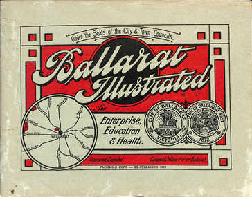
Book, "Ballarat Illustrated", 1972
... vehicles. Tram tracks apparent. Bottom left hand photo shows... with signal gantry and horse drawn vehicles. Tram tracks apparent ...Original c 1914 (see below), facsimile copy - re-published 1972. Original features photos of Ballarat City and Town, its buildings, parks and the various industries and organisations that were in Ballarat at the time of publication, including ESCo. Many photos features ESCo trams. Photos sepia toned. Has some red colour block printing on the front cover and rear, for Star Oil Engines. On inside back cover is a map with the places of interest and tram route map, marked in red. Pages are un-numbered. Original published by Ballarat East Town Council and Ballaarat City Council. On cover has number stamped in black in, "No. 87" (assume facsimile copy No.). Photos with publication show tram No. 21, built 1913 and ESCo photo page shows Mr. Pringle as Manager. Mr Pringle became manager in January 1911, As there is no photos of the "Avenue of Honour", or other mention of the first world war, assume original published about 1913 or 1914. Original shows Engravings and printing by "Campbell Wilson Prop Ltd, Ballarat". See Other Information as well for more listing details. High Resolution image added 31/8/2012 of i2 of ESCo page and i3 for Ballarat identies and sheet i4 extracted for Mr Pringle. PDF scan of full document added 21/5/2019 - see images btm633-1i.pdf and btm633-2i.pdf Notes on "Ballarat Illustrated" Reg. Item No. 733 From notes made by Neville Gower 12/1/1997 Cover: Inside front cover: Last paragraph, "Facilities for Travelling" - Electric trams serve all parts of Ballarat. Page 3: Street Scene, Municipal Town Hall, showing tram wiring Page 7: Street Scene, Lydiard St. North, intersection and tramway centre, with ESCo tram No. 21 in the bottom photo. Other photos features trams as well in Sturt St and Lydiard St. North. Page 9: Street Scene, Top photo of Sturt St. from Lydiard St. looking east, shows piles on right-hand side of road. Car parked by Post Office has a car registration number "9007". Bottom photo, an tram climbing hill, shows double trolley in the street, with early English type of pull offs. Page 13: Street Scenes and Historic Buildings: One of five photos, shows Victoria St. looking East, with tram track prominent in photo and how stone work was set up about the rails and overhead poles. Page 23: Street scene, Gardens North Entrance gates, shows details of gates near St. Aidans Drive. Note double trolley wire on poles, and style of insulators. No trams in photo, three ladies walking down the track. Page 37: Street Scene; Lydiard St views, top left hand photo, shows Railway station and railway gates with signal gantry and horse drawn vehicles. Tram tracks apparent. Bottom left hand photo shows Lydiard St. North, near Post Office, double track with centre poles - Single wire per track. Top right hand photo, showing Cemetery gates in background. Bottom right hand photo - from north end of Lydiard St. South, looking north, with an ESCo tram in background. Also has a parked car on left hand side. Page 45: Street Scenes - Bridge St; top photo at west end of Bridge St. with ESCo No. 11 with possibly double trolley wire in photo. Bottom photo at east end of Bridge St. with tram in background, shows junction. Double trolley heading out to Mt. Pleasant, single trolley for Victoria St. Page 45: Street Scenes - Bridge St; top photo at west end of Bridge St. with ESCo No. 11 with possibly double trolley wire in photo. Bottom photo at east end of Bridge St. with tram in background, shows junction. Double trolley heading out to Mt. Pleasant, single trolley for Victoria St. Page 61: Street Scenes and Historic Buildings - Public Institutions Ballarat - top left hand photo of the Hospital shows some tram track in foreground, with double trolley wire. Top right photo is of the Orphanage, the name of the tram terminus for many years. Page 68: Electric Supply Co. of Victoria's pages - top photo showing powerhouse in background, across the lake, can hardly see anything for the trees, except for the chimney. Bottom photos of the steam Turbo Generators and the switchboard. Gives Mr. P.J. Pringle as Chief Engineer and General Manager. He took over in Jan. 1911. Page 69: Ballarat East Views - features photo of Black Hill open cut, Ballarat East Railway Station, Ballarat Fire Station and "Victoria St. looking East", repeat of photo printed on page 12, but slightly darker. Image on system includes fire station and railway station, - Ballarat East. Page 78: Series of photos of various Ballarat VIP's of the era, fourth one in on top line features "P.J.Pringle, Electric Supply Co." Inside Back cover - map of Ballarat including tram lines and places of interest marked in red. Gives a detailed photographic presentation of Ballarat in 1914.80 page book with, in addition, light green card covers, titled "Ballarat Illustrated". Loose copy of page 9 and 10 held.trams, tramways, ballarat, local history, heritage buildings, esco -
 Melbourne Tram Museum
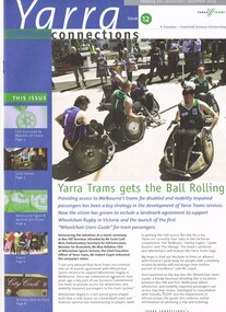
Magazine, Yarra Trams, "Yarra Connections", Dec. 2003
... track maintenance vehicle -"scrubber truck". .2 - Letter... and return of W class trams to route 30. New track maintenance ...Demonstrates a Yarra Trams staff newsletter..1 - Magazine - 8 pages, full colour, centre stapled, printed on recycled paper, titled "Yarra Connections Issue 12, December 2003", published by Yarra Trams. Notes the launch of the "Wheelchair users guide" for tram passenger, Yarra Trams support for Wheelchair Rugby, planning for Vermont South extension, French award for CEO, Hubert Guyot, photo exhibition featuring employees by Georgia Metaxas, Boroondara residents and Travelsmart, Metlink Team Tigers Basketball, Ikea store in Richmond, pram friendly trams, feedback and return of W class trams to route 30. New track maintenance vehicle -"scrubber truck". .2 - Letter on Yarra Trams letterhead, addressed to Ron Wilson of Orange Grove Bayswater, signed by Paul Matthews Marketing Manager forwarding a copy of the magazine to Ron, noting highlights. Gives address details. .3 - Magazine - as for .1 - issue 1 dated October 1999 with a forward by the CEO Steve Macdonald , Camberwell depot, Deputy CEO Hubert Guyot, new logo designs, reduction in tram stops, tennis trams, family day, Docklands route 70 extension and competition. .4 - magazine - 3 fold A4 - issue 9, dated Nov. 2002, Notes the construction of Route 109, W class, St Vincent's Plaza, Gordon Atkins, Docklands tram services, explorer program, Feedback, Line Officers, Corporate Report and Melbourne Museum tram. .5 - magazine - issue 11 - August 2003 - 8 pages - opening of Box Hill line, Harry the Wombat, trams in the press, Welcome to Dennis Cliche, B class seating trial, Metlink, Docklands, trial information at tram stops (early TramTracker) project and route 75. .6 - magazine issue 13 - April 2004 - Australian Open tram service, Collins and Spencer Superstop, tram services, feedback, Metlink, Channel 10 - The Secret life of us, PTC Cricket Squad. .7 - issue 8 - April 2002 - Grand Prix, Box Hill update, Citadis update, Collins and Spring superstop, Australia Open, Fare Evastion and track joints. 8 - issue 10, undated - Australian Open tennis, Eurotram comes to Melbourne, Docklands joins the City Circle, route 109, Box Hill extension and what is a substation.trams, tramways, yarra trams, w class, disability services, vermont south, awards, metlink, route 30, camberwell depot, docklands, route 70, st vincent's plaza, line officers, box hill, route 109, b class, superstops, cricket, tennis, tramtracker, route 75, city circle -
 Eltham District Historical Society Inc
Photograph - Digital Photograph, Marguerite Marshall, One Tree Hill Mine, Smiths Gully, 8 June 2006
... of families and vehicles on the dirt tracks en route to the Caledonia... of families and vehicles on the dirt tracks en route to the Caledonia ...Gold was discovered on One Tree Hill in 1854. The site has been worked intermittently until fairly recent times. Published: Nillumbik Now and Then / Marguerite Marshall 2008; photographs Alan King with Marguerite Marshall.; p53 Though still a working mine, One Tree Hill Mine at Smiths Gully, now stands in a tranquil reserve surrounded by bush and native animals - in contrast to its heyday. In the mid 19th century, when the mine was part of the Caledonia Goldfields, hundreds of men in search of their fortune worked the alluvial gold in the Yarra River, its tributaries and the reefs that made up the goldfields. Miner Stan Bone, assisted by Wilfred Haywood, is the last of the independent gold miners in the area and still uses the quartz crushing battery as miners did when gold was first discovered in the area in 1851.1 Stan, who is the last of six generations of miners in his family, was aged 17 when he began mining on his father Alex’ mine, The Golden Crown in Yarrambat. These days, after blasting the gold-bearing rock in Mystery Reef, one of the four reefs at One Tree Hill, Stan transports it around five kilometres by tip truck to the Black Cameron Mine for crushing. There he uses water from the waterlogged mine, (which still contains gold), as the Happy Valley Creek at One Tree Hill is usually dry.2 The One Tree Hill Mine has been worked for close to a century since it opened around the late 1850s.3 The Swedish Reef was its most productive reef and one of the largest in the area. Around 1859, extractions included 204 ounces (5.8kg) of gold, won from 57 pounds (26kg) of stone.4 Then during World War Two, Stan’s uncle, Bill Wallace, and Alex Bone, closed the mine. In 1973, Stan, with his Uncle Bill, reopened the Black Cameron Mine and worked there until 1988. Stan resumed mining One Tree Hill in 1998. As late as the 1920s gold was picked up by chance! When crossing a gully on his way to vote at the St Andrews Primary School, Bill Joyce picked up some quartz containing gold. This site was to become the Black Cameron Mine. The Caledonia Diggings, named after Scotland’s ancient name by local Scots, began around Market Square (now Smiths Gully) and included Queenstown (St Andrews), Kingstown (Panton Hill) and Diamond Creek. There were also poorer bearing fields in Kangaroo Ground and Swipers Gully (now Research). * None of these compared in riches to the Ballarat and Bendigo fields5, but the Caledonia Diggings continued intermittently for close to 100 years. Gold was discovered in Victoria following a bid to stem the disappearance of much needed workmen to the New South Wales diggings. Several businessmen offered a reward of £200, for the discovery of gold within 200 miles (322 km) of Melbourne. Late in June 1851, gold was first discovered at Andersons Creek, Warrandyte. Then in 1854, George Boston and two other men discovered gold at Smiths Gully. Gold transformed the quiet districts, with a constant flow of families and vehicles on the dirt tracks en route to the Caledonia Diggings. Three thousand people worked the gullies in Market Square, including about 1000 Chinese miners. The square established its own police, mining warden, gold battery, school, shops and cemetery and grog flowed. Market Square flourished until the middle 1860s. Bullocks transported quartz from the Caledonia Goldfields to the crushing machinery at the Queenstown/St Andrews Battery, near Smiths Gully Cemetery. It was destroyed by bushfire in 1962. By the late 1850s, most early alluvial fields were in decline, but minor rushes continued until around 1900 and some until the early 1940s. Some miners did well, although most earned little from their hard labour in the harsh and primitive conditions.6 But according to historian, Mick Woiwod, the gold fields helped to democratise society, as individuals from all walks of life were forced to share experiences, and the ability to succeed, depended less on inherited wealth or social rank.This collection of almost 130 photos about places and people within the Shire of Nillumbik, an urban and rural municipality in Melbourne's north, contributes to an understanding of the history of the Shire. Published in 2008 immediately prior to the Black Saturday bushfires of February 7, 2009, it documents sites that were impacted, and in some cases destroyed by the fires. It includes photographs taken especially for the publication, creating a unique time capsule representing the Shire in the early 21st century. It remains the most recent comprehenesive publication devoted to the Shire's history connecting local residents to the past. nillumbik now and then (marshall-king) collection, gold mining, one tree hill mine, smiths gully -
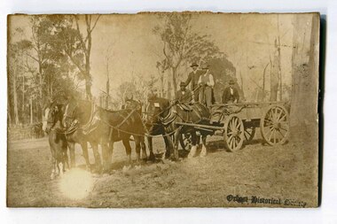 Orbost & District Historical Society
black and white photograph, second half 19th century?
This photograph is a record of the time when horse drawn vehicles were the main form of transport.A black / white photograph of five well - dressed men on a four horse drawn cart. It is on a rough bush track. Three men are standing, the others sitting. There are trees and bush in the background There is another horse - drawn vehicle on the left in the background.transport horse-drawn-vehicle -
 Orbost & District Historical Society
black and white photograph, 1913
... a bush track with a motor vehicle behind them.... a bush track at Hospital Creek. Their vehicle was bogged. The y ...This photograph shows Country Roads Board men clearing a bush track at Hospital Creek. Their vehicle was bogged. The y Roads Board was formed in 1913 1910 it had become apparent that there was a need for a central roads authority to take over responsibility from the Board of Lands and Works for the care and management of the main roads of the state of Victoria. Because there was no consistent and systematic policy for road maintenance Victorian roads were in a deplorable condition. At this time the use of the motor car accentuated the demands for better roads. As a result of these needs the Country Roads Act 1912 was proclaimed in 1913 providing for the establishment of the Country Roads Board as a central road authority with responsibility for those roads within the State considered to be main roads. the C.R.B. was responsible for the construction of roads and bridges including the Snowy River road bridges in Orbost.. This is a pictorial record of transport difficulties in East Gippsland in early 20th century.A large black / white photograph of three men clearing a bush track with a motor vehicle behind them.transport roads road-maintenance country-roads-board -
 Bendigo Military Museum
Photograph - Johnson Ground Elevation Meter (JGEM) Survey Vehicle - Army Survey Regiment, Fortuna, Bendigo, c1960s
This is a set of 16 photograph of the Royal Australian Survey Corps’ Johnson Ground Elevation Meter (JGEM) Survey Vehicle taken at the Army Survey Regiment, Fortuna, Bendigo. The JGEM vehicle was extensively used by RA Svy within Australia from the late 1960s. A limited number of Ground Elevation Meter (GEM) station wagon type vehicles were manufactured by General Motors Corporation (GMC) in the USA for the United States Geological Survey, Canada’s mapping agencies, RA Svy and National Mapping (Natmap). The GEM was a four-wheel drive, four-wheel steer vehicle. Four-wheel steering was necessary to avoid systematic errors caused by non-tracking of front and rear wheels on conventionally steered vehicles. The manufacturer substituted the rear axle with a front axle and connected them to form the four-wheel steering mechanism. The two Australian GEM vehicles, referred to as Johnson GEMs (JGEMs) were converted into right-hand drive. After delivery in 1964, acceptance Natmap and RA Svy testing and operator training was undertaken at the Army's School of Military Survey located at Balcombe, Victoria. A small fifth wheel was mounted on a cantilever arm suspension midway between the front and rear wheels on the right side of the vehicle. It was lowered to and raised from its operating position by use of a constant pressure air cylinder. A telescopic bar, suspended between the front and rear axles, provided the reference datum for the angle measurement. The wheel provided the velocity or distance signal through a pulse generator system. A sensitive pendulum mounted on this bar provided the angle measurement for each minute distance traversed. The JGEM contained electromechanical instruments used to determine relative elevations, by trigonometric principles, along a traversed path. These relative elevations were obtained through apparatus which measures the instantaneous angle of inclination of the road and the instantaneous velocity of the meter along such a path. Road routes over which the JGEM operated were planned so that each started and ended as near as practicable to an existing point of known elevation (formally referred to as a level traverse bench mark). The difference in height from the bench mark and the road surface alongside the JGEM’s fifth wheel was measured with a level and staff. Along each route, mapping control photo reference points where new elevation values were required were identified on aerial photographs. Under favourable conditions it was possible to survey as much as 160km in an ordinary working day. The first of RA Svy’s JGEM operations was undertaken in 1:250,000 scale map areas of Queensland. CPL John Hook was the JGEM’s main operator in the early 1970s undertaking operations covering 1:250,000 scale map blocks over northern Victoria and central NSW, each requiring 36 points (9 runs of photography and 4 points across. SPR Lyn Thompson and SPR Bob McDonagh teamed with CPL Hook on some of these JGEM operations. When RA Svy was integrated into the Royal Australian Engineers in 1996, the JGEM vehicle with the Survey Corps collection was donated to its museum. It is believed to be the last of the original manufactured fleet in existence. The JGEM has undergone extensive refurbishment to achieve roadworthiness and is currently housed at The Australian Army Museum of Military Engineering, Hoslworthy Barracks, NSW. It can be viewed by making an appointment with the museum’s curator.This is a set of 16 photograph of the Royal Australian Survey Corps’ Johnson Ground Elevation Meter (JGEM) Survey Vehicle taken at the Army Survey Regiment, Fortuna, Bendigo. The photographs were on 35mm slide film and were scanned at 96 dpi. They are part of the Army Survey Regiment’s Collection. .1) - Photo, colour, c1960s, Johnson Ground Elevation Meter (JGEM) Survey Vehicle .2) - Photo, colour, c1960s, JGEM instrumentation, on-board computer. .3) - Photo, colour, c1960s, JGEM instrumentation. .4) - Photo, colour, c1960s, JGEM instrumentation, on-board computer. .5) - Photo, colour, c1960s, JGEM tyre pressure controller .6) - Photo, colour, c1960s, JGEM rear doors, SGT Geoff Briggs. .7) - Photo, colour, c1960s, JGEM 5th wheel distance/angle measurement device in lowered position, SGT Geoff Briggs. .8) - Photo, colour, c1960s, JGEM 5th wheel distance/angle measurement device in lowered position. .9) & .10) - Photo, colour, c1960s, JGEM tyre pressure system, SGT Geoff Briggs. .11) - Photo, colour, c1960s, JGEM tyre pressure system. SGT Geoff Briggs. .12) - Photo, colour, c1960s, JGEM levelling scope, levelling staff, unidentified technicians. .13) & .14) - Photo, colour, c1960s, JGEM levelling scope, unidentified technician. .15) & .16) - Photo, colour, c1960s, probably survey operation adjusted height plotted on block base sheet. .1P to .16P - Some of the equipment is annotated on the frame of the 35mm slides.royal australian survey corps, rasvy, army survey regiment, army svy regt, fortuna, asr, surveying -
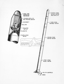 Eltham District Historical Society Inc
Photograph - Black and White Print, NASA, Four stage solid fuel Scout vehicle and cross section, 1960
On reverse: Four stage solid fuel Scout vehicle and cross section of payload instrumentation. First solid fuel rocket used by N.A.S.A. to launch a satellite on orbital trajectory. Front cap comes off and satellite built of tghin mylar plastic film and aluminium foil emerges and inflates. Radio beacon built in for tracking.alan gardiner collection, space industry, 1960, nasa, rocket, scout solid fuel rocket -
 Glen Eira Historical Society
Photograph - Elsternwick Fire Station, Selwyn Street
A photocopied black and white photograph (96mm x 127mm) of the 1891 Elsternwick Fire Brigade on their way to a fire with a crew of three fire fighters in a one-horse cart racing up a track.elsternwick, fire brigades, fire fighters, elsternwick fire brigade, horse drawn vehicles, carts and wagons -
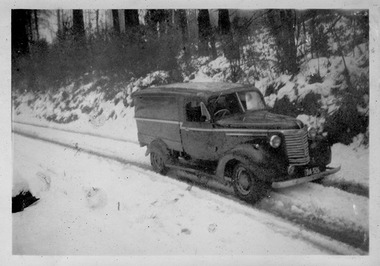 Marysville & District Historical Society
Photograph (Item) - Black and white photograph, c1950
A digital copy of a black and white photograph of one of Barton's Delivery fleet of vehicles from Marysville in Victoria, driving down a snow covered track.A digital copy of a black and white photograph of one of Barton's Delivery fleet of vehicles from Marysville in Victoria, driving down a snow covered track. Thomas John Barton was born in 1836 in Gloucestershire and after his father died in 1850 arrived in Melbourne in 1852 along with his mother, adult sisters, younger brothers, his uncle, his uncle's wife Suzanna and their family. Thomas tried gold mining at Woods Point but found it too difficult. He then partnered with Ewen Hugh Cameron to provide the miners with meat. In 1864 they purchased a plot of land in Marysville and set up a butchers/abattoirs and from there began their business of taking supplies to the miners at the nearby Woods Point and Jamieson goldfields. In 1865 the business was firmly established and Thomas married Selina Croker at Heidelberg and brought her back to Marysville. Their first home was 'The Chestnuts', which included the store, and was situated on the town side next to the Steavenson River. Sadly, in 1876 Selina died of complications after giving birth to their sixth child. Thomas was in need of a nanny to care for his six children, including the newborn baby, and so he employed Emily Ada Sparke, who is the eldest daughter of the local school teacher. Thomas and Emily subsequently marry in 1878 and they go on to have a further 10 children over the next several years. Thomas assisted in the establishment of the first school in Marysville in 1870 and remained a very active member of the community including as a Councillor for the Shire of Healesville, Shire President and he was also appointed as a Justice of the Peace. Thomas died in Carlton in 1911. After their father's death, his sons Fred and Frank took over the family business, which was then known as Barton Bros Store which continued to operate until sometime in the 1970's.marysville, victoria, barton's store, thomas john barton, ewen hugh cameron, woods point, jamieson, gold mining, goldfields, selina croker, the chestnuts, emily ada sparke, shire of healesville, fred barton, frank barton, barton bros store, francis adam barton, frederick john barton, photograph, barton's garage, barton bros stables, chevrolet van -
 Phillip Island and District Historical Society Inc.
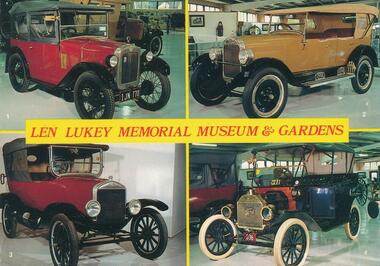
Photograph - Post Card, Color Offset (Aust.) Pty. Ltd, c 1970
A collection of nine postcards donated by the Bass Coast Op Shop. Information on the back of No. 276-05. "Koala Bears were first seen by white explorers in the Blue Mountains, 1798. Early colonists from N.S.W. called it a "monkey bear". Koala means in Aboriginal "does not drink" or "no drink". They are slow-moving, tree-climbing, friendly marsupials with thick woolly fur coats, large ears and rubber nose. They live in gum trees and feed upon their leaves. Babies are born every two years, spending nine months in mother's pouch and then on her back for about six months, then leaving its parents and looking for a tree with comfortable branches."Nine coloured postcards of Phillip Island and wildlife. 276-01. Postcard showing four vintage vehicles displayed in the Len Lukey Memorial Museum & Gardens at the GP Race Track. 1. 1928 Austin Chummy. 2. 1926 Maxwell. 3. 1924 Model T Ford. 4. 1913 Model T Ford. 276-02. Postcard showing penguin in burrow possibly on egg/s 276-03. Postcard with two photographs of penguins coming up the beach at dusk. 276-04. Postcard with three photographs of penguins coming up the beach and people looking over the railing at them. 276-05. Postcard of a koala sitting on a branch. 276-06. Postcard of seals at Seal Rocks with man sitting on the rocks beside one. 276-07. Postcard with four photographs of koalas, penguins, Cowes Jetty and Cowes beach. 276-08. Postcard with three photographs of koalas, penguins and a seal. 276-09. Postcard with four photographs of penguins, koalas, seals and penguins.276-01. Len Lukey Memorial Museum & Gardens. Vehicle description as above in Physical Description. 276-02. Phillip Island, Victoria, Australia. On back: Australian Penguin Reserve, Phillip Island Victoria. 276-03. Australian Penguin Parade Phillip Island. 276-04. Penguins at Phillip Island, Victoria, Australia 276-05. On back: Full description of Koalas - see Historical Information below. 276-06. On back: Making friends at Seal Rocks, Phillip island, Vic. 276-07. Cowes Phillip Island. 276-08. Phillip Island Victoria 276-09. Greetings from Phillip Island. On back: Phillip Island, Victoria, Australia. Interesting aspects of this fascinating Island which gives shelter to some of Australia's unique fauna.wildlife - seals, wildlife - koala, wildlife - penguins, vintage cars, t model ford, len lukey musem, cowes beach, cowes pier, bass coast op shop -
 Halls Gap & Grampians Historical Society
Map - Coloured
Background on Bridle Path up Stony Creek Gorge Pre 1840 C. B. Hall, squatter on Mokepilly Run 1841-1842, first European to discover the Fyans Creek valley, the entrance of which became known as Hall's Gap. He later recorded that he followed a number of tracks which he assumed had been made by the Aboriginies and described one as "leading up a wild romantic glen and over on to the source of the Glenelg River". This could well have been the route taken up Stony Creek gorge by the first timber-cutters in this part of the Grampians to the saddle between the Wonderland and Mt. Difficult ranges known as Valley Gap 1850s/60s Timber cutters and shingle splitters were reported to be moving into the eastern side of the Grampians and by the mid 1860s there were a number of families connected to the supplying of timber to Pleasant Creek living in the "Hall's Gap ranges". John Wakeham, the first store owner in Pleasant Creek in 1854, established a timer-mill in upper Stony Creek Gorge in the late 1850s. Wakeham is credited for the clearing and levelling of the first bridle-path up the gorge. 1870s By the mid 1870s the track had been extended over Valley Gap to the Victoria Forest (the upper region of the Victoria Valley). McKeon's bullock team was known to have hauled red gum from the Valley to Stawell in the late 1870s and the 1880s. 1880s In 1887 an article in the Pleasant Creek news describes the Stony Creek Gorge track as "being a ledge alongside the mountain range, formed in the early days with the aid of earth and timber, along which the bullock teams used to travel to Horsham and plains of the Wimmera beyond." 1890s Gold was discovered in the catchment area of Stony Creek and by the end of the 1890s a new track was built from "near the junction of Fyan's and Stony Creeks, up the gorge to the diggings settlement. The mining Department had paid L300 for its construction and, when completed, the track was "three miles and 30 chains in length, the side cuttings at the narrowest part being 10 feet between" and "the watercourses which cross the track at various points" having been "filled up with rocks rolled down the sides of the hills, and consequently there can be no damage caused by bushfires which destroyed the former wooden bridges erected on the old track to Wakeham's saw-mill, the remains of which are still to be seen at the side of the diggings" The article goes on to further describe the track as one which "can with ease travel with a two horse conveyance either up or down" and that the workmen engaged in the construction of the track would be attending "a ball that night at McKeon's farm near the mouth of the gap to celebrate the successful completion of the undertaking". 1900s At what time the bridle path was extended beyond Valley Gap to the Wartook basin on the Mt. Difficult Range has not yet been determined. However, it is known that, by the turn of the century, people were travelling between Halls Gap and the caretakers' residence at Wartook Reservoir along what was now known as the "Bluff Road. Wartook's embankment had been constructed in 1887 and at that time there was already a track from Rosebrook Station homestead (near the present day Wartook Pottery) to the reservoir. Philip Rose owned both Rosebrook and Wartook Stations from the mid 1840s to the late 1850s and had regularly leased the Wartook basin to Cobb & Co. to rest horses there. 1920s Following the war of 1914-1918, tourism really took off in the Grampians, and Halls Gap rapidly grew. People would travel as far as they could on the many tracks then hike to the many lookouts being discovered by local tour guides. This led to the need for access across the range so that horse riders and the increasing number of vehicles could travel between Horsham and Halls Gap. To this end, the Bluff Road was improved and extended on 1929 and at its opening in March, 1930, by Lady Somers it was renamed the Mt. Victory Road.Map of Mt Victory Road and othersaccess routes, mt victory rd, bridle path, roads -
 Halls Gap & Grampians Historical Society
Flyer - B/W, C 1924-25
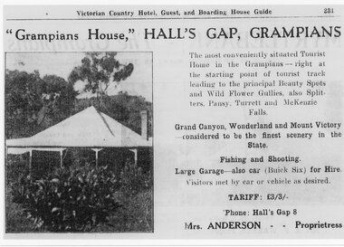
Tariff L 3/3 Mrs Anderson was proprietress "Grampians House," Hall's Gap, Grampians, The most conveniently situated Tourist Home in the Grampians - right at the starting point of tourist track leading to the principal Beauty Spots and Wild Flower Gullies, also Splitters, Pansy, Turrett and McKenzie Falls Grand Canyon, Wonderland and Mount Victory considered to be the finest scenery in the State. Fishing and Shooting. Large Garage - also Car (Buick Six) for Hire. Visitors met by car of vehicle as desired. Phone Halls Gap 8Detail of advertisement for Victorian Country Hotel Guest and boarding house Guide with photo of original housemedia, flyers, accommodation, grampian house -
 Halls Gap & Grampians Historical Society
Photograph - B/W, C ?
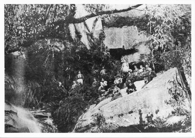
This photo has been copied from an article in the Weekly Times. The falls were in the Roses Gap area and there was once a track leading there. It is probable that the group went there by horse drawn vehicle.The photo shows a group of adults seated on a rocky outcrop at the base of a waterfall, in bushland beside a running creek (at left of photo). All are dressed formally.scenery, waterfalls -
 Eltham District Historical Society Inc
Photograph, Goodwood Powelltown Melbourne Daily
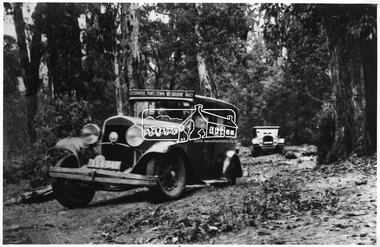
Two cars, probably 1929 Chryslers navigate the forest track probably Kinglake National Park. Front vehicle has sign: "Goodwood Powelltown Melbourne daily". Photo sourced from the Forests Commission of Victoria. Ref. JJ 399This photo forms part of a collection of photographs gathered by the Shire of Eltham for their centenary project book,"Pioneers and Painters: 100 years of the Shire of Eltham" by Alan Marshall (1971). The collection of over 500 images is held in partnership between Eltham District Historical Society and Yarra Plenty Regional Library (Eltham Library) and is now formally known as the 'The Shire of Eltham Pioneers Photograph Collection.' It is significant in being the first community sourced collection representing the places and people of the Shire's first one hundred years.Digital imagesepp, shire of eltham pioneers photograph collection, kinglake, goodwood powelltown melbourne daily, automobile, chrysler, kinglake national park, forest track -
 Eltham District Historical Society Inc
Photograph, Goodwood Powelltown Melbourne Daily rear view
Two vehicles, possibly 1929 Chryslers negotiate a forest track, probably in the Kinglake National Park. Front vehicle has sign: Goodwood Powelltown Melbourne daily". Source: Forests Commission of Victoria. Ref. JJ 397This photo forms part of a collection of photographs gathered by the Shire of Eltham for their centenary project book,"Pioneers and Painters: 100 years of the Shire of Eltham" by Alan Marshall (1971). The collection of over 500 images is held in partnership between Eltham District Historical Society and Yarra Plenty Regional Library (Eltham Library) and is now formally known as the 'The Shire of Eltham Pioneers Photograph Collection.' It is significant in being the first community sourced collection representing the places and people of the Shire's first one hundred years.Digital imagesepp, shire of eltham pioneers photograph collection, kinglake, goodwood powelltown melbourne daily, automobile, forest track, chrysler, kinglake national park -
 4th/19th Prince of Wales's Light Horse Regiment Unit History Room
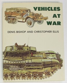
Book, Denis Bishop & Christopher Ellis: Vehicles at War, 1979 (exact)
An account of vehicles which have made history in mechanised warfare. Ranging from tanks, armoured cars, personnel carriers, and gun carriers to vehicles such as jeeps, staff cars, ambulances, traction engines and motor cycles. Examples are from many countries and theatres of war, from the Crimean War to the Cold War. Contains 225 colour illustrations and 261 in black & white. ISBN 0-04-623012-2military history, tanks, armoured fighting vehicles, military vehicles, scout car, armoured cars, half track, military history, tanks, armoured fighting vehicles, military vehicles, scout car, armoured cars, half track -
 4th/19th Prince of Wales's Light Horse Regiment Unit History Room
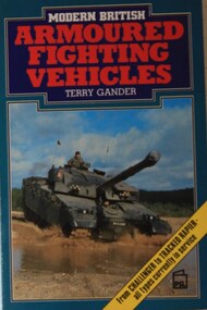
Book, Terry Gander: Modern British Armoured Fighting Vehicles, 1986 (exact)
... are tracked and wheeled reconnaissance vehicles such as Scorpion... are tracked and wheeled reconnaissance vehicles such as Scorpion ...This book gives details of armoured fighting vehicles in service with the British Army of the eighties. Included are tracked and wheeled reconnaissance vehicles such as Scorpion, Scimitar and Fox, armoured personnel carriers, command, engineer and signals vehicles, bridge layers and others. Specifications and performance details are accompanied by constant-scale plans and photographs.ISBN 0-85059-836-2photographs, armour, armoured fighting vehicles, british army, specifications, terry gander, photographs, armour, armoured fighting vehicles, british army, specifications, terry gander -
4th/19th Prince of Wales's Light Horse Regiment Unit History Room
Transmission Assembly, Ferret Scout Car, Daimler, c 1950
The Ferret Scout Car , was developed by the British Army in the late 1940s and came into production in the 1950s. The Ferret first saw service in the British Army in 1952, and a little later in Australia. There were many series and Marks of the Ferret. In Australia two were primarily used. The Mark1, which had no turret and a crew of three, and the Mark2, with a turret and a crew of two. The Australian Army used the Ferrets as scout cars until the 1960s, they were disposed of by public auction in the early 1970s. The Ferret is a light armoured car, intended for light reconnaissance work, they are very mobile and were well suited to their role. The vehicle was designed by Daimler, as a further development on the successful Daimler Dingo of WW2. The Ferret is fully armoured and the standard model of the Ferret Mk2 was further strengthened shortly after its design and became the Mk2/3 (this is the usual model referred as the Mk2). The motor was Roll Royce B60 motor, giving the vehicle a power to weight ratio of 29.35 break horse power per tonne, the vehicle weighs 3.6 tonnes, although a combat weight would be 4.3 tonnes. It is four wheel drive, constant, and has a top speed of 93 k.p.h. (approx 50 m.p.h.). Fuel consumption is only about 34 litres per kilometer. The Ferret is 3.8 metres long by 1.9 metres wide and is 1.9 metres high, not including radio aerials. The ground clearance is .33 of a metre and the track width is 1.5 metres.Ferret Scout Car - B60 No 1 Mk 6A transmission assembly incorporating engine, fluid coupling, gear box and transfer box.Engine Number 12993 List Number 35418 Modification plate marked to Mod 3. ferret scout car, transmission -
4th/19th Prince of Wales's Light Horse Regiment Unit History Room
Transmission Assembly, Ferret Scout Car
The Ferret Scout Car Mark 2, was developed by the British Army in the late 1940s and came into production in the 1950s. The Ferret first saw service in the British Army in 1952, and a little later in Australia. There were many series and Marks of the Ferret. In Australia two were primarily used. The Mark1, which had no turret and a crew of three, and the Mark2, with a turret and a crew of two. The Australian Army used the Ferrets as scout cars until the 1960s, they were disposed of by public auction in the early 1970s. The Ferret is a light armoured car, intended for light reconnaissance work, they are very mobile and were well suited to their role. The vehicle was designed by Daimler, as a further development on the successful Daimler Dingo of WW2. The Ferret is fully armoured and the standard model of the Ferret Mk2 was further strengthened shortly after its design and became the Mk2/3 (this is the usual model referred as the Mk2). The motor was Roll Royce B60 motor, giving the vehicle a power to weight ratio of 29.35 break horse power per tonne, the vehicle weighs 3.6 tonnes, although a combat weight would be 4.3 tonnes. It is four wheel drive, constant, and has a top speed of 93 k.p.h. (approx 50 m.p.h.).Fuel consumption is only about 34 litres per kilometer. The Ferret is 3.8 metres long by 1.9 metres wide and is 1.9 metres high, not including radio aerials. The ground clearance is .33 of a metre and the track width is 1.5 metres.ferret scout car, transmission -
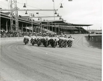
 Victoria Police Museum
Photograph (police motorcycle)
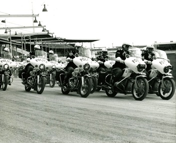
Hondas and BMWs in exhibition formation at a showgrounds or trotting track. There are grandstands in the background and lights over the track. Circa 1973Noel Duffy, Terry Walsh, Ian Taylorpolice vehicles; motor transport branch; motor transport section; motor cycle patrol; police motorcycles; honda motorcycle; bmw motorcycle -
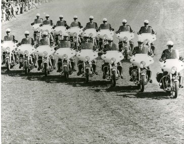
 Victoria Police Museum
Photograph (police motorcycle)
Hondas and BMWs in exhibition formation at a showgrounds or trotting track. There are grandstands in the background and lights over the track and an equestrian field set up in the centre of the track. Circa 1973police vehicles; motor transport branch; motor transport section; motor cycle patrol; police motorcycles; honda motorcycle; bnmw motorcycle -
 Victoria Police Museum
Photograph (police car)
A former patrol car used for driving instruction at the Atwood police training complexStudebaker Cruiser, registration number JES-131, performing on a test track with unidentified driver. Circa 1965police vehicles; wireless patrol; motor transport branch; motor transport section; studebaker cruiser car -
 Victoria Police Museum
Photograph (police motorcycle)
Two rows of Kawasakis being ridden on a grass track. Circa 1960police vehicles; wireless patrol; motor transport branch; motor transport section; motor cycle patrol; police motorcycles; kawasaki motorcycles -
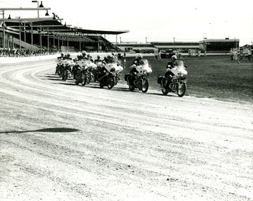
 Victoria Police Museum
Photograph (police motorcycle)
Hondas and BMWs in close formation riding around a track at Ballarat Showgrounds. Circa 1973police vehicles; wireless patrol; motor transport branch; motor transport section; motor cycle patrol; police motorcycles; honda motorcycle; bmw motorcycle