Showing 297 items
matching victorian landscapes
-
 Eltham District Historical Society Inc
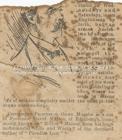
Newspaper - Newspaper Clipping, Melbourne Punch, Artist Walter Withers, PEOPLE WE KNOW, Melbourne Punch, June 17, p. 2, 1897
ARTIST WALTER WITHEBS, whose pictures are now on exhibition at his Melbourne studio on Wednesdays and Saturdays, is an Englishman by birth, but an ardent Australian by adoption. His landscapes are "racy of the soil,” and amongst the most successful work of the kind done by Victorian artists. Withers does most of his work at his Heidelberg home, where he leads a serene life of artistic simplicity amidst the most picturesque surroundings. PEOPLE WE KNOW (1897, June 17). Melbourne Punch (Vic. : 1855 - 1900), p. 2. Retrieved August 22, 2023, from http://nla.gov.au/nla.news-article174626232Journal inscribed: "Mrs Withers 463 Collins St. West Melbourne"art exhibition, art review, john withers collection, melbourne, walter withers studio, 463 collins street west, walter herbert withers, artist -
 Eltham District Historical Society Inc
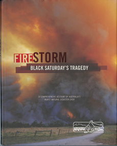
Book, Glenvale School (Lilydale, Vic.). Committee of Parents and Friends, Firestorm : Black Saturday's Tragedy, 2009
This book is dedicated to all who lost so much on the darkest Saturday in Australia's history. Australia's worst natural disaster was a tragedy beyond belief that scarred Victoria physically and the whole Australian nation physiologically. Extreme temperatures, tornado-like wind speeds and tinder-dry land, culminated in the disaster we now know as Black Saturday. Before the sun would set on the blackest day in Australia's history, thousands of hectares would become blackened landscape and an unparalleled loss of lives could only mean that many areas would never be the same again. This graphic pictorial record takes you through the conditions prior to the day, the horrific fires that destroyed both bush and townships alike, the amazing bravery of emergency services personnel and the tragic aftermath. Accounts from eye-witnesses describe a fire like never seen before, a wild fire that outran every warning system. "A comprehensive account of Australia's worst natural disaster ever"black saturday, bush fires, bushfire, fire damage - buildings, victorian bushfires - 2009 -
 Marysville & District Historical Society
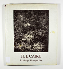
Book - Hardcover book, N.J. Caire Landscape Photographer, 1988
A book of photographs taken by Nicholas John Caire of places and scenery throughout Victoria.A book of photographs taken by Nicholas John Caire of places and scenery throughout Victoria. Photographs by Nicholas John Caire are among the most widely published late nineteenth and early twentieth-century Australian photographs. Between 1875 and 1905 Nicholas Caire travelled the Victorian countryside, looking to capture the scenery for the commercial market. His artistic sensitivity created images which earned him popular acceptance during his lifetime and an enduring place as one of Australia's finest landscape photographers.Hardcover. Front cover photograph-Fairy Scene at the Landslip, Blacks' Spur c1878-9; taken by Nicholas John Caire.For Jane and Clarephotographers, australia, photograpy, landscapes, history, description, travel, views, anne pitkethly, don pitkethly, nicholas john caire, victoria -
 Marysville & District Historical Society
Book, N.J. Caire Landscape Photographer, 1988
A book of photographs taken by Nicholas John Caire of places and scenery throughout Victoria.A book of photographs taken by Nicholas John Caire of places and scenery throughout Victoria. Photographs by Nicholas John Caire are among the most widely published late nineteenth and early twentieth-century Australian photographs. Between 1875 and 1905 Nicholas Caire travelled the Victorian countryside, looking to capture the scenery for the commercial market. His artistic sensitivity created images which earned him popular acceptance during his lifetime and an enduring place as one of Australia's finest landscape photographers.Hardcover. Front cover photograph-Fairy Scene at the Landslip, Blacks' Spur c1878-9; taken by Nicholas John Caire.For Jane and Clarenicholas j caire, photographers, australia, photograpy, landscapes, history, description, travel, views, anne pitkethly, don pitkethly, victoria -
 Greensborough Historical Society
Article - Website, National Trust of Australia (Victoria), Mont Park: Statement written by National Trust of Australia (Victoria), 17/09/2010
Statement of Cultural heritage Significance for Mont Park acquired by Victorian state government in 1909 and used as a mental hospital complex comprising Larundel Kingsbury and Greswell facilities, finally decommissioned in1969. Contains extensive descriptions of regionally significant indigenous and exotic vegetation, landscaped by designer Hugh Linaker.2p. typescriptmont park, larundel, gresswell, hugh linaker -
 Greensborough Historical Society
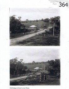
Photograph (copy), Old Bridge and Hotel Lower Plenty, 1925c
2 historical views of the Lower Plenty bridge and hotel. Original photographs are in the Victorian State Library collection.Both the bridge and hotel remain but are in a very different landscape. This shows the area about 110 years ago.A4 photocopy of 2 black and white photographslower plenty, lower plenty hotel, plenty river, lower plenty river bridge. -
 Kiewa Valley Historical Society
Postcard Circa 1950, Lake Guy Dam and Bogong Village, Circa 1950
This postcard was produced in the 1950's for the tourist trade in the Kiewa Valley and Alpine region. It encompasses the period when the State of Victoria was pressured by the ever increasing demand by industry and its population for electricity supplies. Hydro electricity was seen as an untapped natural resource to quench this demand. The Victorian Alps and the rivers flowing into its valleys was ideal for the construction of the Kiewa Hydro Electricity Scheme. The late 1940's saw the development of this scheme and the changing of sections of alpine landscape is covered by this and other postcards/pictures (tourists, construction workers, and established rural populations). This period in time was before the established wildlife and forest/nature groups became political activist who changed legislative acts to protect the environment.This rural region (Kiewa Valley/alpine plains) was at most only significant to a smaller group of winter sports, summer hikers/horse riders and rural farmers/graziers. The numbers of tourists and the increase in the local resident population was boosted by the construction of the Hydro Electricity Scheme. This influx to the regional population resulted in a corresponding diversity in services and brought about an environment that responded to a growing level of tourists and thereby permitting this industry to grow more rapidly than it would have naturally. This postcard details an attraction to the "cleaner" method of providing electricity. This postcard was purchased in 1950 by a surveyor at Landford's Gap.This black and white photograph from a Valentine's postcard is from a V2 Argus photograph postcard. It is on a 200g/m paper density photo side gloss. See 0480 (B) - (F) for other photos of similar postcards.In white lettering " LAKE GUY & BOGONG VILLAGE KIEWA HYDRO-ELECTRIC PROJECT"kiewa valley tourism, victorian alps, alternate energy supplies, alpine population growth -
 Kiewa Valley Historical Society
Postcard Circa 1950, Snowfall at Bogong Village Kiewa Hydro-Electric Project, 1950s
This postcard was produced in the 1950's for the tourist trade in the Kiewa Valley and Alpine region. It encompasses the period when the State of Victoria was pressured by the ever increasing demand by industry and its population for electricity supplies. Hydro electricity was seen as an untapped natural resource to quench this demand. The Victorian Alps and the rivers flowing into its valleys was ideal for the construction of the Kiewa Hydro Electricity Scheme. The late 1940's saw the development of this scheme and the changing of sections of alpine landscape is covered by this and other postcards/pictures (tourists, construction workers, and established rural populations). This period in time was before the established wildlife and forest/nature groups became political activist who changed legislative acts to protect the environment.This rural region (Kiewa Valley/alpine plains) was at most only significant to a smaller group of winter sports, summer hikers/horse riders and rural farmers/graziers. The numbers of tourists and the increase in the local resident population was boosted by the construction of the Hydro Electricity Scheme. This influx to the regional population resulted in a corresponding diversity in services and brought about an environment that responded to a growing level of tourists and thereby permitting this industry to grow more rapidly than it would have naturally. This postcard details an attraction to the "cleaner" method of providing electricity. This postcard was purchased in 1950 by a surveyor at Landford's Gap.This scanned black and white photograph of a postcard, shows vehicles covered in thick snow at Bogong Village in 1950. See 0480(A), (C) - (F) for other similar photos of postcards available at this period."SNOWFALL AT BOGONG VILLAGE KIEWA HYDRO-ELECTRICITY PROJECT"kiewa valley tourism, victorian alps, alternate energy supplies, alpine population growth, bogong village, secv -
 Kiewa Valley Historical Society
Postcard Circa 1950, Scene in Bogong Village Kiewa Hydro-Electric Project, 1950s
This postcard was produced in the 1950's for the tourist trade in the Kiewa Valley and Alpine region. It encompasses the period when the State of Victoria was pressured by the ever increasing demand by industry and its population for electricity supplies. Hydro electricity was seen as an untapped natural resource to quench this demand. The Victorian Alps and the rivers flowing into its valleys was ideal for the construction of the Kiewa Hydro Electricity Scheme. The late 1940's saw the development of this scheme and the changing of sections of alpine landscape is covered by this and other postcards/pictures (tourists, construction workers, and established rural populations). This period in time was before the established wildlife and forest/nature groups became political activist who changed legislative acts to protect the environment. This rural region (Kiewa Valley/alpine plains) was at most only significant to a smaller group of winter sports, summer hikers/horse riders and rural farmers/graziers. The numbers of tourists and the increase in the local resident population was boosted by the construction of the Hydro Electricity Scheme. This influx to the regional population resulted in a corresponding diversity in services and brought about an environment that responded to a growing level of tourists and thereby permitting this industry to grow more rapidly than it would have naturally. This postcard details an attraction to the "cleaner" method of providing electricity. This postcard was purchased in 1950 by a surveyor at Landford's Gap. The couple shown in this photograph would have been employed by the S.E.C. under the Kiewa Hydro-Electricity Scheme.This item is a scanned black and white photograph of a couple walking along a gravel street in Bogong Village in 1950. See 0480 (A) ,(B), (D) - (F) for other photos of similar postcards" SCENE IN BOGONG VILLAGE KIEWA HYDRO-ELECTRIC PROJECT"kiewa valley tourism, victorian alps, alternate energy supplies, alpine population growth, bogong, secv -
 Kiewa Valley Historical Society
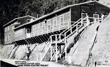
Postcard Circa 1950, Men's Mess No.4 Power Station, Kiewa Hydro-Electric Project
This postcard was produced in the 1950's for the tourist trade in the Kiewa Valley and Alpine region. It encompasses the period when the State of Victoria was pressured by the ever increasing demand by industry and its population for electricity supplies. Hydro electricity was seen as an untapped natural resource to quench this demand. The Victorian Alps and the rivers flowing into its valleys was ideal for the construction of the Kiewa Hydro Electricity Scheme. The late 1940's saw the development of this scheme and the changing of sections of alpine landscape is covered by this and other postcards/pictures (tourists, construction workers, and established rural populations). This period in time was before the established wildlife and forest/nature groups became political activist who changed legislative acts to protect the environment.Although this photo details the eating facilities of the construction workers at the power station it was not only a postcard for the people employed in the Hydro Scheme is was also provided to tourists visiting the area and thus used for promotional purposes.This rural region (Kiewa Valley/alpine plains) was at most only significant to a smaller group of winter sports, summer hikers/horse riders and rural farmers/graziers. The numbers of tourists and the increase in the local resident population was boosted by the construction of the Hydro Electricity Scheme. This influx to the regional population resulted in a corresponding diversity in services and brought about an environment that responded to a growing level of tourists and thereby permitting this industry to grow more rapidly than it would have naturally. This postcard details an attraction to the "cleaner" method of providing electricity. This postcard was purchased in 1950 by a surveyor at Landford's Gap. The men shown in this photograph would have been employed by the S.E.C. under the Kiewa Hydro-Electricity Scheme.This item is a scanned black and white photograph of a construction worker walking from stairs leading down from the men's mess building, in 1950. See 0480 (A) -(C), (E) - (F) for other photos of similar postcards"MEN'S MESS No.4 POWER STATION AREA, KIEWA HYDRO-ELECTRIC PROJECT" "ARGUS PHOTO V.IIkiewa valley tourism, victorian alps, alternate energy supplies, alpine population growth, secv -
 Kiewa Valley Historical Society
Postcard Circa 1950, Mt. Beauty Village, Kiewa Hydro-Electricity Project, circa 1950
This postcard was produced in the 1950's for the tourist trade in the Kiewa Valley and Alpine region. It encompasses the period when the State of Victoria was pressured by the ever increasing demand by industry and its population for electricity supplies. Hydro electricity was seen as an untapped natural resource to quench this demand. The Victorian Alps and the rivers flowing into its valleys was ideal for the construction of the Kiewa Hydro Electricity Scheme. The late 1940's saw the development of this scheme and the changing of sections of alpine landscape is covered by this and other postcards/pictures (tourists, construction workers, and established rural populations). This period in time was before the established wildlife and forest/nature groups became political activist who changed legislative acts to protect the environment. The regulatory pondage on the northern aspect of the village had no water over-spill from the unfinished power station.This rural region in 1950 (Kiewa Valley/alpine plains) was at most only significant to a smaller group of winter sports, summer hikers/horse riders and rural farmers/graziers. The numbers of tourists and the increase in the local resident population was boosted by the construction of the Hydro Electricity Scheme. This influx to the regional population resulted in a corresponding diversity in services and brought about an environment that responded to a growing level of tourists and thereby permitting this industry to grow more rapidly than it would have naturally. This postcard details an attraction to the "cleaner" method of providing electricity. This postcard was purchased in 1950 by a surveyor at Landford's Gap. The couple shown in this photograph would have been employed by the S.E.C. under the Kiewa Hydro-Electricity Scheme.This item is a scanned black and white photograph of a panoramic view of Mount Beauty Village in 1950 (a closed village, entry by pass only). The regulatory pondage has earthen walls but no water.See 0480 (A) -(D) and (F) for other photos of similar postcards"MT. BEAUTY VILLAGE KIEWA HYDRO-ELECTRIC PROJECT"kiewa valley tourism, victorian alps, alternate energy supplies, alpine population growth -
 Kiewa Valley Historical Society
Postcard Circa 1950, Howman Gap Hostel under snow Kiewa Hydro-Electric Project, Circa 1950
This postcard was produced in the 1950's for the tourist trade in the Kiewa Valley and Alpine region. It encompasses the period when the State of Victoria was pressured by the ever increasing demand by industry and its population for electricity supplies. Hydro electricity was seen as an untapped natural resource to quench this demand. The Victorian Alps and the rivers flowing into its valleys was ideal for the construction of the Kiewa Hydro Electricity Scheme. The late 1940's saw the development of this scheme and the changing of sections of alpine landscape is covered by this and other postcards/pictures (tourists, construction workers, and established rural populations). This period in time was before the established wildlife and forest/nature groups became political activist who changed legislative acts to protect the environment.This rural region (Kiewa Valley/alpine plains) was at most only significant to a smaller group of winter sports, summer hikers/horse riders and rural farmers/graziers. The numbers of tourists and the increase in the local resident population was boosted by the construction of the Hydro Electricity Scheme. This influx to the regional population resulted in a corresponding diversity in services and brought about an environment that responded to a growing level of tourists and thereby permitting this industry to grow more rapidly than it would have naturally. This postcard details an attraction to the "cleaner" method of providing electricity. This postcard was purchased in 1950 by a surveyor at Landford's Gap.This item is a scanned black and white photograph of a panoramic view of Howman Gap Hostel under snow in 1950 (a closed village, entry by pass only). This accommodation was for construction workers only. See 0480 (A) -(E) for other photos of similar postcards.On the photo, " Howman Gap Hostel under snow Kiewa Hydro-Electric Project" . On postcard address and personal information side "V.2 Valentine's Post Card "kiewa valley tourism, victorian alps, alternate energy supplies, alpine population growth, bogong, secv, howman's gap hostel -
 Kiewa Valley Historical Society
Photograph Farm Land, Mount Beauty Acreage before Golf Course, Circa 1950
This photograph is a "snap shot" in time circa 1950s detailing the rural environment before the effects of the Kiewa Valley Hydro Scheme altered the basic rural setting of the valley. The golfing fairway was being mapped out on previous grazing land, before the laying of a golf course, for use by the construction workers and auxiliary administration employees of the Victorian State Electricity Commission. This photograph details a dramatic period in time which saw an enormous change to the exclusively rural area of the Kiewa Valley region in the mid 1900s. This change presented both physical and mental challenges to the existing quiet rural inhabitants of the valley. The State of Victoria had to make adjustments to the changing demands imposed by population and industrial expansions. The development of cleaner energy supplies to a growing population has its downside ,which ever way the intrusion into the "natural" landscape is made.Black and white photograph detailing surveyor posts for construction of golf course. Land used, before establishment of the Mount Beauty Village, as farming/grazing cattle and viewed towards Mount Bogong and its Alpine ranges. The photo is on 200gms paper and not on photographic paper.nilmount beauty in the 1940s - 1950s, grazing in the kiewa valley, sec victoria -
 Kiewa Valley Historical Society
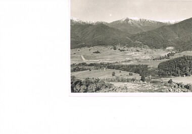
Photograph Transmission lines Mount Beauty, 66 KVA Transmission lines from Clover Power Station, Circa 1950
This photograph is a "snap shot" in time circa 1950s detailing the rural environmental change and the progressive effects of the Kiewa Valley Hydro Scheme on the basic rural setting of the valley (note the sparsity of rural infrastructure). This photograph shows the beginning of the accommodation and administration buildings for use by the construction workers and auxiliary administration employees of the Victorian State Electricity Commission. It also provides a view of the landscape before extensive development of Pondage and other non rural buildings.This photograph details a dramatic period in time which saw an enormous change to the exclusively rural area of the Kiewa Valley region in the mid 1900s (see sparse rural buildings/houses). This change presented both physical and mental challenges to the existing quiet rural inhabitants of the valley. The State of Victoria had to make adjustments to the changing demands imposed by population and industrial expansions. The development of cleaner energy supplies to a growing population has its downside ,which ever way the intrusion into the "natural" landscape is made. The construction of the large Pondage at the centre of the photograph is a good example.This black and white photograph of a panoramic view of the Kiewa Valley (Mount Beauty SEC construction workers village) shows the newly completed transmission line towers delivering electrical power(66KVA) from the Clover Power Station. The photo is on 200gms paper and not on special photographic paper.mount beauty 1940 to 1950s, development of sec kiewa hydro scheme, sec victoria -
 Kiewa Valley Historical Society
Photograph of Snow Covered Catchment Area Vic, Snow Covered Catchment Area Victorian Alps - 1950s, Circa 1950
This photograph details (early to mid1950s), the Victorian Alpine region when this remote area was part of a "lay back" rural landscape,occasionally visited by recreational adventurers and some wayward tourists. The mountain ranges had provided an adequate barrier against the way-would traveller, but with the opening up of this region by the provision of improved roadways and accommodation facilities, courtesy of the Kiewa Valley Hydro Electricity Scheme, changes such as tourism and its impact upon the "natural" state started to show its side effects (clearing of the land). The expansion of the European immigration numbers (1950s) coming into Australia was increasing after World War II which not only provided increased construction workers to the region but also immigrants who appreciated alpine regions. Some of these immigrants contributed to the expansion of the region and provided for a greater degree of diverse professions and rural related work force.This photograph depicts the borderline in time between an exclusively rural based population and respective activities(early 1900s)to the present (2000 on wards) integrated village, tourist and retiree/holiday area. The time when land was exclusively used in agriculture and Alpine grazing lands is over. The Kiewa Valley is loosing its hiding place and is becoming more and more a source of untapped residential land and winter time recreational adventure lands. The changes brought about by modern technologies involving recreational activities such as hang gliding, gliding (local airstrip), mountain bikes, car rallies and their associated clubs is providing for an increased short term population boost. These together with the attractions for retirees is changing not only the physical nature of the Kiewa valley but also its "soul".This item is a black and white photograph of a section of snow covered catchment area in the Victorian Alps in the mid 1900. It is on 200 gms paper but not on photographic paper and has a white boarder (3 mm).kiewa valley tourism, victorian alps, alternate energy supplies, alpine population growth -
 Kiewa Valley Historical Society
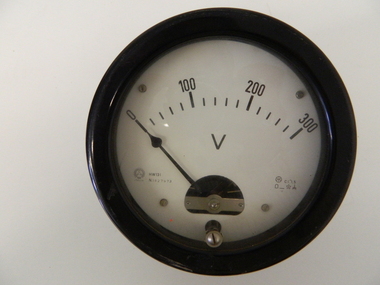
Meter Volt, mid to late 1900's
This analog voltmeter is quite a large (industrial type) apparatus which permits the easy monitoring of electrical variations within the large SEC Victoria Hydro Scheme's electrical generators. These generators are powered by the hydro force of "stored" water at a higher altitude. The establishment of both the NSW and Victorian Hydro schemes was achieved from the mid 1900's to the 1960's. At this point in time the need for additional power sources to quench both an industrial and domestic demand for electricity was purely an economic and not and environmental (carbon reduction) factor. This hydro scheme was instigated by "the Government of the day" as a bold move and was the major force of the World War II refugee and "technical" workforce inclusion of skilled and unskilled migration into the Australian environment. Although this mass "invasion" of workers with families was thought of in some circles as intrusive, the expansion of population post war years and its integration into the Australian rural sector, produced the multi- lingual multi-cultural diversity of later years. This voltmeter is very significant to the Kiewa Valley as its use was introduced during the Kiewa Hydro Scheme. Although only a small apparatus it was part of the explosion of human resources into the valley. This influx of population transformed the region from that of a basically quiet rural region to one which evolved into both an industrial and a larger residential community. This evolution in the valley created a change, not only in the "physical" landscape but also the socio-economic expansion which permitted other "tourist" based industries into the valley. This analog volt meter has two metal rods protruding from the "back" of instrument with screw on points for the negative and the positive leads allowing the "current" to flow across the calibrated resistors to indicate on the "face" side the strength of the voltage "power". The "face" of the instrument has a zero point and then five evenly graduated marks from Zero to the "100, 200 and 300" marked points of measures. A large "V" below these pointers indicates that they represent levels of voltage. Three small screws hold the "face" in place. At the back of the meter is an aluminium "clasp" with three protruding screws (positioning fasteners) and a a screw tightening fixture for the correct fastening of the "clasp" into the correction location on the meter "board".Manufacturer's logo "CSG" underneath "ITALIA"kiewa valley tourism, victorian alps, alternate energy supplies, alpine population growth -
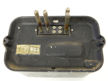
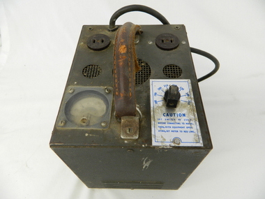 Kiewa Valley Historical Society
Transformer Lamp System, late 1950's
This transformer lamp system, which has a dial to transform 240 volts to a minimum of 32 volts was used by electrical technicians to inspect internal parts of the large generators (even in small confined spaces). The reason for the reduction of the 240 volts to the 32 volts was for the safety of the inspector. The SEC Victoria Hydro Scheme's electrical generators are powered by the hydro force of "stored" water at a higher altitude. The establishment of both the NSW and Victorian Hydro schemes was achieved from the mid 1900's to the 1960's. At this the point in time the need for additional power sources to quench both an industrial and domestic demand for electricity was purely an economic and not and environmental (carbon reduction) factor. This hydro scheme was instigated by "the Government of the day" as a bold move and was the major force of the World War II refugee and "technical" workforce inclusion of skilled and unskilled migration into the Australian environment. Although this mass "invasion" of workers with families was thought of in some circles as intrusive, the expansion of population post war years and its integration into the Australian rural sector, produced the multi- lingual multi-cultural diversity of later years.This transformer lamp is very significant to the Kiewa Valley as it was introduced as a very small part of the explosion of human resources into the valley. This influx of population transformed the region from that of a basically quiet rural region to one which evolved into both industrial and larger residential community. This evolution in the valley created a change, not only in the "physical" landscape but also the socio-economic expansion which permitted other "tourist" based industries into the valley. This is also a specific electronic item which was manufactured in Melbourne and not sourced from Europe or Asia. This demonstrates the fast evolution of Australian technology to a high standard compatible to that of the rest of the world.This heavy hand held electrical transformer (transforms 240 volts to 32 Volts) an has one leather handle on the top with three small (gauze filtered) air holes. It also has two 2 pin directional cable distribution (clipsal) in/out points 10amps / 240 volts. There is one glassed in volts/ac meter and one variable switch (180 to 150 voltage in settings of 10 volt increments.There are two vents (one on each of the smaller sides). There is also one three pin electrical lead coming out from the top.On one side is a manufacturer's plaque with "ELECTRONIC A & R EQUIPMENT MELBOURNE" and underneath "TYPE 1719, PRI V. 180 250" underneath "V.A. 1250" underneath "CYC 50" underneath "SEC V. 115" underneath "SEC A. 10 . 8". The label on topside "CAUTION SET SWITCH TO 250 v BEFORE CONNECTING TO MAINS THEN, WITH EQUIPMENT OPERATING, SET METER TO RED LINE.kiewa hydro electricity scheme, victorian state electricity commission, transformers -
 Kiewa Valley Historical Society
Meter Millivolt, after 1950
This milli-volt meter was manufactured after 1950 and used by the SEC Vic (Kiewa Hydro Electricity Scheme) from that date until late 1900's. It was used to measure very small voltages associated with the operation of the various Hydro Generators. The readings were able to be shown by the resistor in use in the current circuit. During this time period, high quality testing instruments were either sourced from Europe or England.This milli-volt meter is very significant to the Kiewa Valley as it was used by those electrical technicians, who were part of the Kiewa Hydro Scheme. An "off spin" from the Scheme was the beginning of an explosion in "human" resources into the Kiewa Valley. This influx of population transformed the region from that of a basically quiet rural region to one which evolved into both industrial and larger residential community. This evolution in the Kiewa Valley created a change, not only in the "physical" landscape(better roads and infrastructure), but also the socio-economic growth within the Valley allowing other "tourist" based industries to expand within the valley and Alpine areas.This millivolts DC meter was used in the 1950's. It is contained in a wooden box and has two coloured (red/black, positive and negative) screw tight knobs which have bake-lite connections. It also has a covered (black tin) view meter marked from zero to 10 millivolts. Underneath this and within a round bake-lite is a small adjustment screw. The top of the box is fastened onto the main structure by six brass screws. The back of the structure is fastened by eight brass screws and there are four small bake-lite rest knobs.On the face of the millivolt compartment , and at the top "TO BE USED WITH DIAL HORIZONTAL TEMP. COEF. +- .08 % PER oC. Underneath the scale "MILLIVOLTS D.C. F.G." (LEAD RESIS. .05 OHMS)" underneath and to the left "MADE IN ENGLAND BY" "EVERSHED & VIGNOLES Ltd" and to the right "No. 857842" underneath Regd. TRADE MARK MEGGERkiewa valley tourism, victorian alps, alternate energy supplies, alpine population growth -
 Kiewa Valley Historical Society
Relay Protection Instrument, Circa 1950's
This protection relay apparatus (a large electrical fuse), which permits the easy monitoring and disconnection of faulty electrical apparatus connected to the large SEC Victoria Hydro Scheme's electrical power producing generators. These generators are powered by the hydro force of "stored" water at a higher altitude. The establishment of both the NSW and Victorian Hydro Schemes was achieved from the early 1900's to the 1960's. At this point in time the need for additional power sources to quench both an industrial and domestic demand for electricity was purely an economic and not and environmental (carbon reduction) factor. This hydro scheme was instigated by "the Government of the day" as a bold move and was the major force of the World War II refugee and "technical" workforce inclusion of skilled and unskilled migration into the Australian environment. Although this mass "invasion" of workers with families was thought of in some circles as intrusive, the expansion of population post war years and its integration into the Australian rural sector, produced the multi- lingual multi-cultural diversity of later years.This protection relay is very significant to the Kiewa Valley as its use was introduced during the Kiewa Hydro Scheme. Although only a small apparatus it was part of the explosion of human resources into the valley. This influx of population transformed the region from that of a basically quiet rural region to one which evolved into both an industrial and a larger residential community. This evolution in the valley created a change, not only in the "physical" landscape but also the socio-economic expansion which permitted other "tourist" based industries into the valley.This protection relay unit has a black painted metal shell with four copper enclosed "prongs" fastened to the rear of the housing(from a bake-lite plate) . Between these "prongs" are four "empty" points allowing additional "screw on" bases. The front glass enclosed meter and recorder allows for the identification and automatic disconnection of any faulty equipment connected to the main power generator. This equipment acts similarly to a modern day circuit breaker found on the electrical circuit boards of residential homes.On the top section of the front panel "ASEA" to the left "Made in Sweden" and to the right "Frabrique en Suede" below this "RIS" below this a graph and next to it two columns of numbers and a pointer for each setkiewa hydro electricity scheme, victorian state electricity commission, relays, generators -
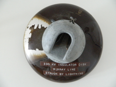 Kiewa Valley Historical Society
Insulator Disk High Voltage, 1964
This insulator disk for the high voltage carrying electrical cables was manufactured in 1964 and used by the SEC Vic (Kiewa Hydro Electricity Scheme) from that date until late 1900's. It was used to connect high voltage cables to their "towers" going from various Hydro Generators to and from power "stations". During this time period, high quality "cable" insulators were manufactured in Japan. In an earlier time they would have been sourced from Europe or England. After the 1950's the sourcing of electrical hardware was being influenced by the lower costs obtainable from Japan. Later on other Asian sources also became available.The need for a mountainous and a large area of operational requirements, such as the SEC Vic Kiewa Hydro Electricity Scheme, to distribute the electricity produced in the Victorian Alps to the major users required power transmission lines to "carry" high above the sometimes inaccessible land mass electricity generated at the power stations to the various sub stations along the valleys and ranges to flatter populated regions. The significance of this insulation "high voltage" disk to the Kiewa Valley region relates to the impact of modern technology (at that time) upon a mainly rural environment. These power lines are a stark visual "show" of the impact that the "Scheme" has on the mostly rural landscape of the Kiewa Valley and what a boost of "modern" equipment into the area has taken place. The "Hydro Scheme" had facilitated the transition of a semi rural area to an advanced rural region within a shorter time frame, than would have taken under "normal" evolutionary time. The speed of information of all "new technology" had a relatively slow assimilation rate before the SEC Kiewa Hydro Scheme came to those living in the then quieter rural communities. This high voltage (330 KV) insulation disk is made from non conductive porcelain stoneware. It is highly polished brown in colour and has a clip fastening for the high voltage cable to be attached to. This disk was hit by lightning and the burn marks are quite noticeable. The top metal connector has a "mushroom" extension jutting below the semi cone like insulation disk. Also four circular ridges or grooves (old 78 rpm disc recording style).Cable bell on top of insulation disk "4K " next to it the international symbol for electricity (triangle containing one horizontal line under one V line and one vertical flame like line.) On the opposite side "2" and to the right "64"sec vic kiewa hydro scheme, alternate energy supplies, alpine (above ground) high voltage electricity cables, volt cable, 330000 volt cable -
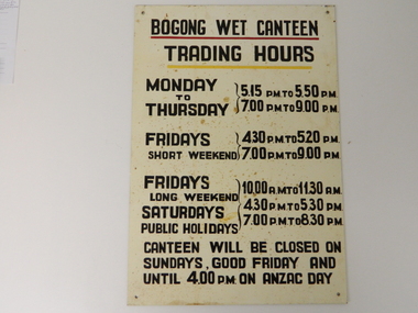 Kiewa Valley Historical Society
Sign Canteen Painted, Circa 1950
This sign is a part of the "human" factor required for remote and difficult, large impact (both labour and other resources) projects. It is one of the "human" factors which was clearly used in the big 1930's to the 1970's "landscape redevelopment" schemes which started in the early 1900's and is highly regarded as lifting the Australian psyche of only primary producers to an industrial level, equal to any in the world.This "Wet Canteen" sign was installed at the entrance of the Bogong "workers" village "provision's hut" detailing the operational times for the SEC Victorian staff and construction workers, involved in the building of the Kiewa Hydro Electricity Scheme to obtain alcoholic beverages. This facility lasted for over the extensive period (1938 to 1961) of the "Schemes" building phase. This large project was the forerunner when industrial legislation provided for the welfare of workers living in the Bogong Village. The provision of facilities such as a "wet canteen" was of the utmost importance not only to ensure that the long running project was both successful, production wise, but also that its employees were not only physically but also mentally healthy. This sign details that all aspects required for a fit and productive labour force were in place, in this remote and demanding work environment. The majority of heavy equipment and machinery used was either made in England or Europe. A section of the specialised workforce came from local and European expertise in dam construction and water management in alpine terrain. The majority of labour came from migrants and some specialists recruited from England and Europe. At this point in time, the quality of the machines used came from England, Europe and the USA and could not be matched from anywhere else in the developed world. With a specialised workforce came the responsibility of providing all the "comforts of home" including alcoholic beverages. On site accommodation for the workforce is still a requirement for some mining areas but high market returns have produced fly in/out labour.This anodised metal sign has been "block" stenciled on. Black lettering and numbers with the main headings underlined with a red and a yellow line(emphasising the headings)In black stenciled type "BOGONG WET CANTEEN" underneath this "TRADING HOURS" Below this "MONDAY TO THURSDAY 5.15 PM TO 5.50 PM, 7.00 PM TO 9.00 PM" "FRIDAYS SHORT WEEKEND 4.30 PM TO 5.20 PM 7.00 PM TO 9.00 PM" Below this "FRIDAYS LONG WEEKEND 10.00AM TO 11.30 AM" Below this "SATURDAYS PUBLIC HOLIDAYS 4.30 PM TO 5.30 PM 7.00 PM TO 8.30 PM" bELOW THIS "CANTEEN WILL BE CLOSED ON SUNDAYS, GOOD FRIDAY AND UNTIL 4.00 PM ON ANZAC DAY"saucer, plate, secv, state electricity commission of victoria, canteen, bogong mess hall, recreational amenities, socialisation of sec vic kiewa hydro scheme labour force -
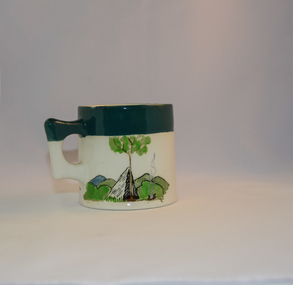 Kiewa Valley Historical Society
Mug Stoneware
This ceramic mug is titled "Bill Bogong's Mug" in honour of one of Australia's Scouting (Rovers) notable office holders, Mr.W.F."Bill" Waters. He was born on 22nd August 1897 in Taralgon, Victoria, Australia and died 8th October 1968 in Fitzroy, Victoria. He was instrumental in the Rovers building two chalets in the Victorian Alps. The Victorian Award of the National Rover Service Award(1980) has been named after Bill Waters. Bill Waters was also the leader of the first team that climbed Mount Bogong in winter in 1929. Also was part of rescue team of what is now know as the Cleve Cole tragedy on Mt Bogong in the mid 1930's. There is also a water fall named after him Waters Falls on the Bogong High Plains. W.F."Bill" Waters aka "Bill Bogong" (Bogong mountain, were his ashes were scattered), was not only a prominent bush walker (Melbourne Walking Club) of the high country (Victorian Alps) but was instrumental in establishing two Chalets. One of these Chalets was the first one to be built on the Bogong High Plains. This item, "Bill Bogong's Mug" is what the Flinders Petrie(famous English Egyptologist/Archaelogist) Rover Crew(formed in 1940) presented newly invested members of the exclusive(200 membership) Alpine Rover Crew. The Melbourne Walking Club has a long history with the Victorian High Plains area, of which the Kiewa Valley is an integral part of the Victorian Alpine Region. Due to the connections Bill Waters has with the Bogong High Plains and Mt Bogong this cup has a lot of significance to the social history of the area.. Round glazed stoneware mug, white in colour, with a heritage green coloured band covering the top rim and handle. Written inscription on the front "Bill Bogong's Mug" in large print and beneath it, in smaller print, "with compliments from Flinders Petrie Rover Crew" The other side of the mug is a free hand landscaped drawing of green bush and blue hills with a tree supporting a tent and a camp fire (with smoke rising from it).To the left of the inscription is the Scout (Rover) emblem coloured black with an unraveled and unwritten signage scroll fowler ceramics, local alpine history, alpine rovers, scouts, mugs, mt bogong, bogong high plains -
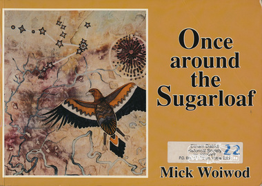 Eltham District Historical Society Inc
Book, Mick Woiwod, Once around the Sugarloaf : the transformation of a Victorian landscape and the story of its people / Mick Woiwod, 1992
... Victorian landscape and the story of its people / Mick Woiwod..... Once around the Sugarloaf : the transformation of a Victorian ...Paperback; 301 p. : ill., ports., maps ; 21 x 30 cm.ISBN 0646106198 [signed by author on title page]sugarloaf mountain -
 RSL Victoria - Anzac House Reference Library and Memorabilia Collection
Photograph, Macleod Repatriation Sanitorium, circa 1914
The former Mont Park/Bundoora Psychiatric and Repatriation Hospitals Complex consisted of seven hospitals on a site of 185 hectares. The site comprising the Mont Park and Strathallen estates was consolidated by the Victorian government by purchase and transfer from the Closer Settlement Board in 1909 . The Mont Park Hospital commenced in 1910 with the building of the Farm Workers Block . In 1912 the landscape gardener Hugh Linaker was employed to layout the grounds of Mont Park and other State mental hospitals. The other hospitals were gradually split off from the Mont Park administration to form separate entities included among these was the Macleod Repatriation Hospital (1915), An agreement was made with the Defence Department in 1914 for the latter to erect the Mont Park central block (the "Chronic Wards") for use as a Military Hospital, and for it later to revert to the State as portion of Mont Park Hospital. The buildings now known as the Chronic Wards were completed in this way in 1916 and used as the Australian General Hospital no. 16 for the duration of the war. One wing of this building was set aside for mental patients during this period. Silver gelatin photographww1, macleod repatriation sanitorium, mont park -
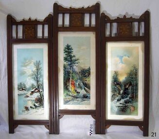 Flagstaff Hill Maritime Museum and Village
Furniture - Screen, Thomas Hope, 1905-1913
The fire screen was part of the original furnishings of the Lighthouse Keeper's Quarters in Merri Street, Warrnambool. It was made by Lighthouse Keeper, Thomas Hope. Thomas served two terms as an assistant lighthouse keeper in Warrnambool. His first term was from 1905 to 1907. He later returned from 1910 to 1913, when he was appointed as Keeper five months after the untimely death of his predecessor Peter Quinn. Woodworking was one of Thomas Hope’s hobbies, and the three-panel fire screen he made as a lighthouse keeper is now in the Flagstaff collection and is displayed in the Lighthouse Keeper’s Cottage. Thomas Hope 1857 - 1928 Thomas James Hope was born in Camden, Surrey, England in 1857. His father, also called Thomas, was reputed to be a member of the Royal Family, and Thomas Hope Junior his illegitimate son. Thomas was subsequently brought up on the estate of the Earl of Hopetoun in Somerset and it was thought that Thomas was the Earl’s grandson. Against the wishes of those in charge of Thomas, he joined the navy at an early age, seeing much of the world until he settled in New Zealand at the age of twenty-four. After some years in New Zealand, he came to Australia to live. One of the jobs Thomas Hope had prior to becoming an assistant lighthouse keeper in 1896 was as a cook in the Lunatic Asylum at Sunbury, Victoria. He served as an assistant keeper at Shortlands Bluff, Gabo Island, Split Point and Warrnambool, retiring in 1918. He bought a house in Nicholson St, Warrnambool and died in March 1928. He is buried in the Warrnambool cemetery. Thomas Hope is recorded in family history as being of short stature and, not surprisingly given his alleged aristocratic connections, possessed a beautiful speaking voice. He and his wife Elizabeth nee Waters, whom he married in New Zealand, had six children (Thomas, killed in World War One), Ellen (Nell), Nora (who was married at the Warrnambool lighthouse keepers cottage), William (who died in Warrnambool), Marion and Alan. Joseph Hoover (Dec 29, 1830, to Aug 7, 1913) Joseph Hoover, the printer of the pictures on the screen, was born in Baltimore, of Swiss-German heritage. He was trained as an architectural woodturner. In 1856 Hoover moved to Philadelphia and began producing elaborate wooden frames in his wood-turning and framing business. By 1865 Hoover had started to produce popular prints for publishers and artists, which included noted Philadelphia artist James F. Queen. In the 1880s Hoover set up a complete plant specialising in chromatography, the process of producing colour prints from lithographic plates. The coloured prints he produced were affordable to business and private customers. In 1893 his son Henry L., a trained lithographer, joined the company as overseer and it was called J. Hoover & Son. It became one of the largest in America by the turn of the century. Hoover won a medal for Excellence for his Chromolithographs of James Queen’s works. In 1904 Joseph’s other son, Joseph W, joined the business as a partner and the company was called Jos. Hoover & Sons. Hoover died of a heart attack in 1913. He was survived by his wife and six children: two sons who were also his business partners, and four daughters. The firm continued in production until around 1985. Hoover’s prints included scenes, still life and landscapes of America and other locations. They were sold in America and overseas to countries including Canada, Germany, Mexico and England. The three-panelled screen in the Lighthouse Keeper’s Cottage was made by the Assistant Lighthouse Keeper, Thomas Hope during one of his two terms at the Lighthouse Keepers' Quarters. It is the only object in the collection known to be connected to Hope. The Lighthouse Keeper's Cottage is part of the Lady Bay Lighthouse Complex, which is listed on the Victorian Heritage Register for being of historical, scientific (technological) and architectural significance to the State of Victoria.Fire screen comprising three black wood framed panels hinged together. Each panel contains a glass-encased print depicting a rural landscape. Ornate stencil cut wood edging and quilt-inspired parquetry sits above each panel. The central panel is taller than those either side. Screen is lined in black-painted cardboard.Printed at the base of each of the three prints “COPYRIGHT 1896 BY J. HOOVER & SON, PHILAD’’A.”flagstaff hill, warrnambool, shipwrecked coast, flagstaff hill maritime museum, firescreen, thomas hope junior, ellen (nell) hope, nora hope, william hope, marion hope, alan hope, jos. hoover & sons of philadelphia, lighthouse keeper, assistant lighthouse keeper, carved screen, merri street, lighthouse keeper's cottage, lighthouse residence, lighthouse, wood carving, lighthouse complex, lady bay lighthouse, fire screen -
 Marysville & District Historical Society
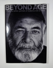
Book, Murrindindi Shire Council, Beyond Age-From the ashes: portraits of resilience, love and loss, 2011
The devastating Victorian bushfires of February 2009 claimed the lives of 173 people. Since then, residents and property-owners throughout the Shire of Murrindindi have rallied together to reclaim their homes, their communities, their relationships and the landscapes they love. Many of them are senior citizens, who have demonstrated through their resilience, wisdom and sense of humour that age often means nothing more than numbers. From CFA volunteers to church-wardens, shearers to scone-makers, older members of the Shire of Murrindindi continue to play their parts in helping communities rise from the ashes. These are their portraits-and some of their stories.Front cover has a black and white photograph of a bearded man whose story is in the book. The back cover has a photograph of a man with his back to the camera and the blurb about the book.non-fictionThe devastating Victorian bushfires of February 2009 claimed the lives of 173 people. Since then, residents and property-owners throughout the Shire of Murrindindi have rallied together to reclaim their homes, their communities, their relationships and the landscapes they love. Many of them are senior citizens, who have demonstrated through their resilience, wisdom and sense of humour that age often means nothing more than numbers. From CFA volunteers to church-wardens, shearers to scone-makers, older members of the Shire of Murrindindi continue to play their parts in helping communities rise from the ashes. These are their portraits-and some of their stories.black saturday, bushfire, photographs, portraits, victoria -
 Marysville & District Historical Society
Book - Hardcover book, N.J. Caire Landscape Photographer, 1988
A book of photographs taken by Nicholas John Caire of places and scenery throughout Victoria.A book of photographs taken by Nicholas John Caire of places and scenery throughout Victoria. Photographs by Nicholas John Caire are among the most widely published late nineteenth and early twentieth-century Australian photographs. Between 1875 and 1905 Nicholas Caire travelled the Victorian countryside, looking to capture the scenery for the commercial market. His artistic sensitivity created images which earned him popular acceptance during his lifetime and an enduring place as one of Australia's finest landscape photographers.Hardcover. Front cover photograph-Fairy Scene at the Landslip, Blacks' Spur c1878-9; taken by Nicholas John Caire.For Jane and Clarephotographers, australia, photograpy, landscapes, history, description, travel, views, anne pitkethly, don pitkethly, nicholas john caire, victoria -
 Marysville & District Historical Society
Painting (Item) - Oil painting, Isaac Whitehead, A spring morning near Fernshaw 1880, 1880
A copy of an early oil painting of Fernshaw in Victoria.A copy of an early oil painting of Fernshaw in Victoria by Isaac Whitehead. Isaac Whitehead (1819–1881) was an Irish-Australian artist who worked in watercolour and pastel. He was also a picture framer and art promoter. It is believed that Isaaz Whitehead emigrated to Australia with his family in either 1853 or 1858. Isaac Whitehead died at his home 50 Punt Road, Prahran, Melbourne, on 21 April 1881. Isaac Whitehead had established himself as the foremost picture framer in Melbourne by 1860, known for his highly ornate frames with floral decorations. Among the clients of his framing business were Louis Buvelot, Nicholas Chevalier, and Eugene von Guérard. In his own paintings, he painted a number of scenes of the forests of Gippsland, Victoria. His work focused on the rich landscapes with trees and ferns, with a high degree of botanical detail. His work won him two medals and his work was posthumously exhibited at 1884 Victorian Jubilee Exhibition, the 1886 London Colonial and Indian Exhibition, and the 1888 Melbourne Centennial Intercolonial Exhibition. Fernshaw was a rural township 63 km northeast of Melbourne and 10 km northeast of Healesville. Situated on the Watts River, near where a log had fallen making a convenient crossing, Fernshaw was settled in the 1860s. It provided good country for orchards and berry growing. The location was at the foot of Blacks Spur, with Mounts Juliet and Mondah rising on either side, providing spectacular scenery. There were nearby fern gullies giving rise to the name – ‘shaw’ is old English for thicket or wood. By 1875 Fernshaw had a post office (1865), two hotels, a school (1871), and stores. It was famed for its beauty, attracting tourists. In 1886 the Melbourne and Metropolitan Board of Works began work on the Watts River water catchment scheme – later to become Maroondah – and the Board obtained approval for the catchment country to be reserved and kept free of settlement. This required the removal of the Fernshaw township, which was completed by about 1890.isaac whitehead, fernshaw, victoria, louis buvelot, nicholas chevalier, eugene von guerard, gippsland, victorian jubilee exhibition, london colonial and indian exhibition, melbourne centennial intercolonial exhibition, watts river, healesville, blacks spur, mount juliet, mount mondah -
 Marysville & District Historical Society
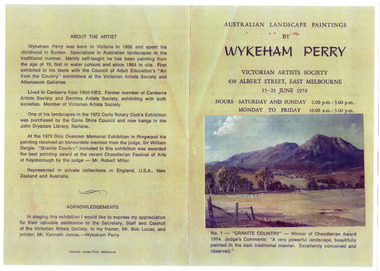
Booklet (Item) - Artshow Catalogue, Victorian Artists Society, Australian Landscape Paintings by Wykeham Perry, 1974
A copy of a catalogue from an art show of paintings by Wykeham Perry that was held at the Victorian Artists Society in 1974.A copy of a catalogue from an art show of paintings by Wykeham Perry that was held at the Victorian Artists Society in 1974. Wykeham Lindley Perry grew up near Marysville in Victoria and painted local scenes from a very early age. wykeham lindley perry, victorian artists society, marysville, victoria -
 Marysville & District Historical Society
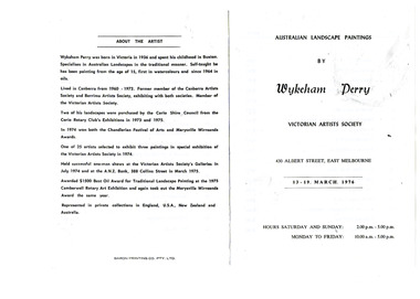
Booklet (Item) - Art show Catalogue, Victorian Artists Society, Australian Landscape Paintings by Wykeham Perry, 1976
A copy of a catalogue from an art show of paintings by Wykeham Perry that was held at the Victorian Artists Society in 1976.A copy of a catalogue from an art show of paintings by Wykeham Perry that was held at the Victorian Artists Society in 1976. Wykeham Lindley Perry grew up near Marysville in Victoria and painted local scenes from a very early age. wykeham lindley perry, victorian artists society, marysville, victoria