Showing 416 items
matching city of camberwell
-
![Cr. W.H.S. Dickinson, Mayor [of Kew] 1946-47, 1960-61](/media/collectors/550653872162f11fb04854aa/items/5922be6bd0cde6131c21cfa1/item-media/5c1b161221ea840a58f4a66b/item-fit-380x285.jpg) Kew Historical Society Inc
Kew Historical Society IncPhotograph, Cr. W.H.S. Dickinson, Mayor [of Kew] 1946-47, 1960-61, 1946
Kew achieved independence from the Boroondara Roads Board in 1860. As a new municipality, its first three leaders were designated as chairmen. On becoming a borough in 1863, its leaders were identified as mayors. The earliest photographs date from ca.1906, when the Town of Kew commissioned the noted local photographer Josiah E Barnes to produce standardised portraits of former mayors to be displayed in the Mayoral Chamber of the Town Hall. The collection also includes photographs by other well-known photographic studios such as Burlington Studios, Melba – Melbourne, Stuart Tompkins, Spencer Shier and Talma & Co. The majority of mounts identify the photographer. Eighty photographs are housed in their original frames.This portrait is one of a series of mounted and framed photographic portraits of Mayors and Town Clerks of the former Borough, Town and City of Kew, for the period 1863 to 1969. The portraits were transferred by the City of Kew to the Kew Historical Society in March 1989. A Significance Assessment in 2018, funded by the National Library of Australia confirmed the historic, and often artistic significance of the series. Framed portrait of Cr. W.H.S. Dickinson, Mayor of Kew 1946-47, 1960-61. The mounting and framing of the photograph follows a typical layout or style in that each is framed in dark wood, glazed, and laid down on an inscribed board. The inscription identifies the name of the mayor and the year/s that he/she served.Cr. W.H.S. Dickinson / Mayor 1946-47, 1960-61 Stuart Tompkins / Camberwellmayors of kew (vic), cr. w.h.s. dickinson, australian photographers - stuart tompkins camberwell, kew (vic.) — municipal collection -
![Cr. W.D. Vaughan, Mayor [of Kew] 1937-1938 and 1947-1948](/media/collectors/550653872162f11fb04854aa/items/5922be86d0cde6131c21e128/item-media/5c1b12fe21ea810a58620f86/item-fit-380x285.jpg) Kew Historical Society Inc
Kew Historical Society IncPhotograph, C Stuart Tompkins ARPS, Cr. W.D. Vaughan, Mayor [of Kew] 1937-1938 and 1947-1948, 1937
Kew achieved independence from the Boroondara Roads Board in 1860. As a new municipality, its first three leaders were designated as chairmen. On becoming a borough in 1863, its leaders were identified as mayors. The earliest photographs date from ca.1906, when the Town of Kew commissioned the noted local photographer Josiah E Barnes to produce standardised portraits of former mayors to be displayed in the Mayoral Chamber of the Town Hall. The collection also includes photographs by other well-known photographic studios such as Burlington Studios, Melba – Melbourne, Stuart Tompkins, Spencer Shier and Talma & Co. The majority of mounts identify the photographer. Eighty photographs are housed in their original frames.This portrait is one of a series of mounted and framed photographic portraits of Mayors and Town Clerks of the former Borough, Town and City of Kew, for the period 1863 to 1969. The portraits were transferred by the City of Kew to the Kew Historical Society in March 1989. A Significance Assessment in 2018, funded by the National Library of Australia confirmed the historic, and often artistic significance of the series. Framed portrait of Cr. W. D. Vaughan, Mayor of Kew 1937-1938 and 1947-1948. The mounting and framing of the photograph follows a typical layout or style in that each is framed in dark wood, glazed, and laid down on an inscribed board. The inscription identifies the name of the mayor and the year/s that he/she served.Cr. W.D. Vaughan / Mayor 1937-1938 and 1947-1948 C Stuart Tompkins / ARPS / Camberwellmayors of kew (vic), cr. w. d. vaughan, kew (vic.) — municipal collection -
![Cr. Frederick William Dods, Mayor [of Kew] 1949-50](/media/collectors/550653872162f11fb04854aa/items/5922beb2d0cde6131c21fc54/item-media/5c1a472c21ea760a58adfefb/item-fit-380x285.jpg) Kew Historical Society Inc
Kew Historical Society IncPhotograph, Cr. Frederick William Dods, Mayor [of Kew] 1949-50, 1949
Kew achieved independence from the Boroondara Roads Board in 1860. As a new municipality, its first three leaders were designated as chairmen. On becoming a borough in 1863, its leaders were identified as mayors. The earliest photographs date from ca.1906, when the Town of Kew commissioned the noted local photographer Josiah E Barnes to produce standardised portraits of former mayors to be displayed in the Mayoral Chamber of the Town Hall. The collection also includes photographs by other well-known photographic studios such as Burlington Studios, Melba – Melbourne, Stuart Tompkins, Spencer Shier and Talma & Co. The majority of mounts identify the photographer. Eighty photographs are housed in their original frames.This portrait is one of a series of mounted and framed photographic portraits of Mayors and Town Clerks of the former Borough, Town and City of Kew, for the period 1863 to 1969. The portraits were transferred by the City of Kew to the Kew Historical Society in March 1989. A Significance Assessment in 2018, funded by the National Library of Australia confirmed the historic, and often artistic significance of the series. Framed portrait of Cr. Frederick William Dods, Mayor of Kew 1949-50. The mounting and framing of the photograph follows a typical layout or style in that each is framed in dark wood, glazed, and laid down on an inscribed board. The inscription identifies the name of the mayor and the year/s that he/she served.Cr. Frederick William Dods / Mayor 1949-50 Stuart Tompkins Camberwellmayors of kew, cr. frederick william dods, australian photographers - stuart tompkins camberwell, kew (vic.) — municipal collection -
![Cr. V.M. Luke, Mayor [of Kew] 1950-1](/media/collectors/550653872162f11fb04854aa/items/5922bec9d0cde6131c220c75/item-media/5c1abe1621ea7e0a5819bb14/item-fit-380x285.jpg) Kew Historical Society Inc
Kew Historical Society IncPhotograph, Cr. V.M. Luke, Mayor [of Kew] 1950-1, 1950
Kew achieved independence from the Boroondara Roads Board in 1860. As a new municipality, its first three leaders were designated as chairmen. On becoming a borough in 1863, its leaders were identified as mayors. The earliest photographs date from ca.1906, when the Town of Kew commissioned the noted local photographer Josiah E Barnes to produce standardised portraits of former mayors to be displayed in the Mayoral Chamber of the Town Hall. The collection also includes photographs by other well-known photographic studios such as Burlington Studios, Melba – Melbourne, Stuart Tompkins, Spencer Shier and Talma & Co. The majority of mounts identify the photographer. Eighty photographs are housed in their original frames.This portrait is one of a series of mounted and framed photographic portraits of Mayors and Town Clerks of the former Borough, Town and City of Kew, for the period 1863 to 1969. The portraits were transferred by the City of Kew to the Kew Historical Society in March 1989. A Significance Assessment in 2018, funded by the National Library of Australia confirmed the historic, and often artistic significance of the series. Framed portrait of Cr. V. M. Luke, Mayor of Kew 1950-1. The mounting and framing of the photograph follows a typical layout or style in that each is framed in dark wood, glazed, and laid down on an inscribed board. The inscription identifies the name of the mayor and the year/s that he/she served.Cr. V.M. Luke / Mayor 1950-1 Stuart Tompkins / Camberwellmayors of kew (vic), cr. v. m. luke, australian photographers - stuart tompkins camberwell, kew (vic.) — municipal collection -
![Cr. C.H. Simpson, Mayor [of Kew] 1951-2](/media/collectors/550653872162f11fb04854aa/items/5922bee4d0cde6131c221e31/item-media/5c1abcd121ea7d0a58c7bd19/item-fit-380x285.jpg) Kew Historical Society Inc
Kew Historical Society IncPhotograph, Cr. C.H. Simpson, Mayor [of Kew] 1951-2, 1951
Kew achieved independence from the Boroondara Roads Board in 1860. As a new municipality, its first three leaders were designated as chairmen. On becoming a borough in 1863, its leaders were identified as mayors. The earliest photographs date from ca.1906, when the Town of Kew commissioned the noted local photographer Josiah E Barnes to produce standardised portraits of former mayors to be displayed in the Mayoral Chamber of the Town Hall. The collection also includes photographs by other well-known photographic studios such as Burlington Studios, Melba – Melbourne, Stuart Tompkins, Spencer Shier and Talma & Co. The majority of mounts identify the photographer. Eighty photographs are housed in their original frames.This portrait is one of a series of mounted and framed photographic portraits of Mayors and Town Clerks of the former Borough, Town and City of Kew, for the period 1863 to 1969. The portraits were transferred by the City of Kew to the Kew Historical Society in March 1989. A Significance Assessment in 2018, funded by the National Library of Australia confirmed the historic, and often artistic significance of the series. Framed portrait of Cr. C. H. Simpson, Mayor of Kew 1951-2. The mounting and framing of the photograph follows a typical layout or style in that each is framed in dark wood, glazed, and laid down on an inscribed board. The inscription identifies the name of the mayor and the year/s that he/she served.Cr. C.H. Simpson / Mayor 1951-2 Stuart Tompkins / Camberwellmayors of kew (vic), australian photographers - stuart tompkins camberwell, kew (vic.) — municipal collection -
![W. D. Birrell, Town Clerk [Kew] 1936 -](/media/collectors/550653872162f11fb04854aa/items/5922c01dd0cde9131c35460b/item-media/5c22673821ea6713f45cc993/item-fit-380x285.jpg) Kew Historical Society Inc
Kew Historical Society IncPhotograph, Stuart Tompkins Studios, W. D. Birrell, Town Clerk [Kew] 1936, c.1938
In Kew’s Civic Century (1960), Cr. W.D. Vaughan described William Dickie Birrell M.B.E. (1899-1974) as follows: “Mr. W. D. Birrell, who had been on the staff of the Country Roads Board after his return from active service with the First A.I.F., was appointed assistant town clerk on February 15, 1921. On Mr. Harrison’s retirement he was appointed town clerk and city treasurer, and has given outstanding service. His knowledge of municipal administration has been acknowledged by the Government calling on his services to advise on amendments to the Local Government Act. He is a past president of the Town Clerks Institute, and on the nomination of that body was honoured by Her Majesty the Queen in 1958 with the award of the M.B.E. He still occupies the position and is held in the highest esteem not only by the Kew Council, but also by local government administrators throughout the metropolitan area.” (page 132) He died on 7 May 1974, and his ashes were interred at the Boroondara General Cemetery. This portrait is one of a series of mounted and framed photographic portraits of Mayors and Town Clerks of the former Borough, Town and City of Kew, for the period 1863 to 1969. The portraits were transferred by the City of Kew to the Kew Historical Society in March 1989. A Significance Assessment in 2018, funded by the National Library of Australia confirmed the historic, and often artistic significance of the series. Framed portrait of W. D. Birrell - Town Clerk of the City of Kew from 1936 -. The mounting and framing of the photograph follows a typical layout or style in that it each is framed in dark wood, glazed, and laid down on an inscribed board. The inscription identifies the name of the town clerk and the year/s that he served.W.D. BIRRELL / TOWN CLERK 1938-town clerks - kew (vic), w.d. birrell, photographers - stuart tompkins studios - camberwell (vic), kew (vic.) — municipal collection -
 Kew Historical Society Inc
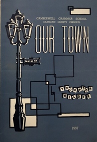
Programme, 'Our Town' / by Thornton Wilder, 1957
The back page of the programme includes details of previous productions: 1950 - The Resignation of Mr. Bagsworth, The Shirt, 1951 - Richard of Bordeaux, 1952 - Ned Kelly, 1953 - Saint Joan, 1954 - Treasure Island 1955 - Toad of Toad Hall, and 1956 School for Scandal. Arthur Henry Dear was an employee of the City of Kew, acting as Hall Keeper of the Kew Recreation Hall in Wellington Street, and later the new Kew City Hall in Cotham Road. The Arthur Dear Collection contains memorabilia - tickets, programmes, invitations - as well as his identification badge. Items in the collection dates from the 1940s to the 1960s. The Kew Recreation Hall (Wellington Street) and later the Kew City Hall (Cotham Road) were major locations in suburban Melbourne in the postwar period for civic and private events including theatre productions and exhibitions. The Arthur Dear Collection (in conjunction with the scrapbooks compiled by Marion Tilley) provide a comprehensive snapshot of performing arts in Kew during the 1940s, 1950s and 1960s. The collection includes valuable data about performances, performers, directors etc., during this period. Theatre programme for a production of Our Town by the Camberwell Grammar School Dramatic Society. The 4-page programme includes a cast list and information about supernumeraries. arthur dear collection, performing arts -- kew -- victoria, kew recreation hall -- wellington street, theatre memorabilia, camberwell grammar school dramatic society -
 Kew Historical Society Inc
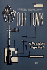
Programme, Camberwell Grammar School Dramatic Society, 'Our Town' / by Thornton Wilder, 1957
The back page of the programme includes details of previous productions: 1950 - The Resignation of Mr. Bagsworth, The Shirt, 1951 - Richard of Bordeaux, 1952 - Ned Kelly, 1953 - Saint Joan, 1954 - Treasure Island 1955 - Toad of Toad Hall, and 1956 School for Scandal.The Kew Recreation Hall (Wellington Street) and later the Kew City Hall (Cotham Road) were major locations in suburban Melbourne in the postwar period for civic and private events including theatre productions and exhibitions. The Arthur Dear Collection (in conjunction with the scrapbooks compiled by Marion Tilley) provide a comprehensive snapshot of performing arts in Kew during the 1940s, 1950s and 1960s. The collection includes valuable data about performances, performers, directors etc., during this period. Theatre programme for a production of Our Town by the Camberwell Grammar School Dramatic Society. The 4-page programme includes a cast list and information about supernumeraries. arthur dear collection, theatre memorabilia, theatre programmes, camberwell grammar school dramatic society -
 Kew Historical Society Inc
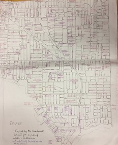
Plan, Gwen McWilliam, Annotated Plan of City of Boroondara, c.1995
Gwen Barton McWilliam (nee: Nelson), OAM, BA (1933- ). Gwen McWilliam is well known as an authority on the history of Boroondara and the author of a large number of books and pamphlets about the City. She was awarded the medal of the Order of Australia in 2001 ‘for service to the community of Hawthorn and district, particularly through the research, documentation and publication of its history.’ Digitally annotated part plan of the City of Boroondara, created by Council (Library?) staff, based on annotated plans provided by the historian Gwen McWilliam, identifying significant landholdings, subdivisions and key dates. On the plan Gwen McWilliam noted that the attempt to copy her annotations had resulted in incorrect data being included, so the plans were never published. For plans including her original 1993 annotations, see 2017.0143 and 2017.0144.Council markings in pinksubdivisions - hawthorn, subdivisions - kew, subdivisions - camberwell, subdivisions - balwyn, subdivisions - surrey hills, subdivisions - canterbury, gwen mcwilliam -
 Kew Historical Society Inc
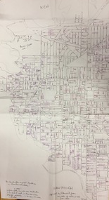
Plan, Gwen McWilliam, Annotated Plan of City of Boroondara, c.1995
Gwen Barton McWilliam (nee: Nelson), OAM, BA (1933- ). Gwen McWilliam is well known as an authority on the history of Boroondara and the author of a large number of books and pamphlets about the City. She was awarded the medal of the Order of Australia in 2001 ‘for service to the community of Hawthorn and district, particularly through the research, documentation and publication of its history.’ Digitally annotated part plan of the City of Boroondara, created by Council (Library?) staff, based on annotated plans provided by the historian Gwen McWilliam, identifying significant landholdings, subdivisions and key dates. On the plan Gwen McWilliam noted that the attempt to copy her annotations had resulted in incorrect data being included, so the plans were never published. For plans including her original 1993 annotations, see 2017.0143 and 2017.0144.Council additions in pinksubdivisions - hawthorn, subdivisions - kew, subdivisions - camberwell, subdivisions - balwyn, subdivisions - surrey hills, subdivisions - canterbury, gwen mcwilliam -
 Kew Historical Society Inc
Plan, Gwen McWilliam, Annotated Plan of City of Boroondara, c.1995
Gwen Barton McWilliam (nee: Nelson), OAM, BA (1933- ). Gwen McWilliam is well known as an authority on the history of Boroondara and the author of a large number of books and pamphlets about the City. She was awarded the medal of the Order of Australia in 2001 ‘for service to the community of Hawthorn and district, particularly through the research, documentation and publication of its history.’ Digitally annotated part plan of the City of Boroondara, created by Council (Library?) staff, based on annotated plans provided by the historian Gwen McWilliam, identifying significant landholdings, subdivisions and key dates. On the plan Gwen McWilliam noted that the attempt to copy her annotations had resulted in incorrect data being included, so the plans were never published. For plans including her original 1993 annotations, see 2017.0143 and 2017.0144.Additions in pink by City of Boroondarasubdivisions - hawthorn, subdivisions - kew, subdivisions - camberwell, subdivisions - balwyn, subdivisions - surrey hills, subdivisions - canterbury, gwen mcwilliam -
 Kew Historical Society Inc
Plan - Subdivision Plan, Plan of Subdivision of Part of Crown Portion 84 / Parish of Boroondara / County of Bourke / Lodged Plan No. 2217, Twentieth Century
Pru Sanderson, in her groundbreaking ‘City of Kew Urban Conservation Study : Volume 2 - Development History’ (1988), summarised the periods of urban development and subdivisions of land in Kew. The periods that she identified included 1845-1880, 1880-1893, 1893-1921, 1921-1933, 1933-1943, and Post-War Development. These periods were selected as they represented periods of rapid growth or decline in urban development. An obvious starting point for Sanderson’s groupings involved population growth and the associated economic cycles. These cycles also highlighted urban expansion onto land that was predominantly rural, although in other cases it represented the decline and breakup of large estates. A number of the plans in the Kew Historical Society’s collection can also be found in other collections, such as those of the State Library of Victoria and the Boroondara Library Service. A number are however unique to the collection.The Kew Historical Society collection includes almost 100 subdivision plans pertaining to suburbs of the City of Melbourne. Most of these are of Kew, Kew East or Studley Park, although a smaller number are plans of Camberwell, Deepdene, Balwyn and Hawthorn. It is believed that the majority of the plans were gifted to the Society by persons connected with the real estate firm - J. R. Mathers and McMillan, 136 Cotham Road, Kew. The Plans in the collection are rarely in pristine form, being working plans on which the agent would write notes and record lots sold and the prices of these. The subdivision plans are historically significant examples of the growth of urban Melbourne from the beginning of the 20th Century up until the 1980s. A number of the plans are double-sided and often include a photograph on the reverse. A number of the latter are by noted photographers such as J.E. Barnes.Undated Plan of Subdivision of Crown Portion 84 in what is now Kew. The area shown is bordered by Burke Road, Harp Road, Arglye Road and Normanby Road.subdivision plans -- kew (vic), harp road, burke road, normanby road, lady loch's drive, gladstone street, second avenue, first avenue -
 Kew Historical Society Inc
Plan - Subdivision Plan, J Hurrey, Section 115 in the Parish of Boroondara Near Richmond Bridge, 1853
Despite the plans claims that it is a subdivision near the Richmond Bridge, Section 115 was located at what is now Camberwell Junction. While the plan only lists government roads rather than named streets, the section was located on the east side of Burke Road, stretching up the hill from the current Junction. Research on Trove, conducted by Kerry Fairbank, discovered an advertisement for unsold lots in Section 115 which clarifies the extent and location of subsequent land sales in the original section. The original article can be viewed through the link in the catalogue record. The interesting link to Kew is the reference to James Beavan as the purchaser of lots 14 and 15. The historian Gwen McWilliam has notes that a Mr Beavan changed his name from Bevan. The Bevans were descendants of the Derricks family of Kew. This subdivision plan is the earliest original map or plan in the collection which shows parts of what is now the City of Boroondara, dating from circa 1853. It provides important information for researchers on subsequent subdivisions following the original land sales in [Camberwell] Boroondara. The site, on the east side of Burke Road is a highly-significant and historic site. This is believed to be the only extant copy of the subdivision in public collections.A small plan on parchment listing 28 lots, between one and two acres each, for sale in Section 115 in the Parish of Boroondara, dating from 1853 when the portion was subdivided.Obverse: Lot 16 "Joseph Duval", Lots 14 & 15 "James Beavan". Other annotations (measurements) are unreadable. Reverse: "KH-981 / Section 115 in the Parish of Boroondara / Near Richmond Bridge / 1640T. / J Duval / 14-15 J. Beavanparish of boroondara, subdivision plans - camberwell, section 115 - boroondara, subdivision plans -- camberwell (vic), riverscape road, burke road, camberwell junction -
 Kew Historical Society Inc
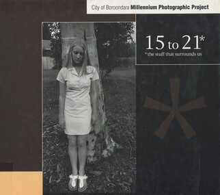
Book, City of Boroondara, 15 to 21: the stuff that surrounds us, 2001
... Camberwell, Vic. : City of Boroondara, 2001 1 v. (unpaged... that surrounds us Camberwell, Vic. : City of Boroondara, 2001 1 v ...Fifteen to twenty-one, the stuff that surrounds us Millennium photographic project : 15 to 21, the stuff that surrounds usCamberwell, Vic. : City of Boroondara, 2001 1 v. (unpaged) : ill. ; 22 x 26 cm non-fictionFifteen to twenty-one, the stuff that surrounds us Millennium photographic project : 15 to 21, the stuff that surrounds usphotography -- artistic -- victoria -- boroondara -
Surrey Hills Historical Society Collection
Document - Plans, Andrew Wood, Building plans associated with Andrew Wood, builder of Surrey Hills, 1920s
These plans were associated with Mr Andrew Wood, a contract builder who worked in the 1920s and built many Californian bungalows in Surrey Hills and surrounding suburbs. Andrew Wood was born in Chiltern in 1861 to Andrew and Ellen Wood (MS: Green). His father had emigrated from Falkirk, Scotland. As a young man Andrew worked as a carpenter in the mines in South Africa (c 1899). He married Eleanor Agnes Stuchbery in Hamilton, Victoria in May 1901. They had 5 children - Doris (M Roberts), Robert Andrew, Donald Allen, Jean (M Cowan), and Gwenyth (M Bray). The first 2 children were born in Hawthorn; the other 3 in Surrey Hills. The family home at 286 Canterbury Road, Surrey Hills (on the corner of Middlesex Road) was built by Andrew. Andrew died in 1940; Eleanor died in 1977, aged 100 years. After Eleanor's death the house was sold and demolished. Surrey Lighting was established on the site. Gwenyth May Wood (3 May 1917, Surrey Hills - 5 Jan 2004) married Leslie David Charles Bray (1921-1983). Gwenyth was the donor's mother. Andrew, Eleanor and one son Robert are buried in Box Hill Cemetery - B-071-0028. .1: Specifications & plans for the kinder hall, Howard Street, Mont Albert for the Mont Albert Methodist Church, May 1925 .2 Plans for a proposed villa, 48 Payne's Paddock, Highfield Road, Canterbury for Mr E H Sillifant, dated 22/4/1920 .3 Plans for a timber villa for Mrs J A Burchell at Riversdale Road, Surrey Hills, stamped 9/5/1922 .4 Plan of a garage at Victoria avenue, Canterbury; stamped 14/2/1922 .5 Building permit & receipt from City of Hawthorn re Lot 16 Homebush Crescent; dated 7/4/1925 .6 Plans for a concrete house at Camberwell for Mr H W Field andrew wood, builders, box hill cemetery, kindergartens, mont albert methodist church, building plans, highfield road, ernest horatio sillifant, victoria avenue canterbury, lot 16 homebush crescent, californian bungalows, h w field -
 Surrey Hills Historical Society Collection
Book, Diary of 138 Spr. R Garford M.M. Battalion and Div.Sig.Coy A.I.F
By arrangment with local and family history librarian, Myra Dowling, this diary was transcribed by Sandra Dexter from the original, which was donated to the City of Boroondara Library Service following the Boroondara Remembers project in 2015. It is a day-to-day account of a soldier's experience going to fight in World War 1, 1914-1919. Robert Thomas Garford (SERN 1138) was born in Fitzroy in 1892. He was aged 23 and living in Camberwell when he enlisted on 14 September 1914. He embarked from Melbourne on board HMAT A38 Ulysses on 22 December 1914. He was a sapper with the 2nd Divisional Signal Company. He was awarded a Military Medal: 'At CLERY, near MT.ST. QUENTIN, on the 31st of August 1918, this soldier was engaged as a linesman at the Brigade Forward Station. Throughout the day forward lines were repeatedly broken by enemy shell fire. Despite this Sapper FARFORD [sic], with very conspicuous coolness patrolled the lines from end to end repairing one break after another. His untiring efforts were responsible for the constant maintenance of communications from the Brigade Station to the Battalions.' Source: 'Commonwealth Gazette' No. 115, 10 October 1919. He returned to Australia 3 December 1918. He married Annie Christina Devine in 1941. They lived at 16 York Street, Surrey Hills and later 17 Blackburn Street, Surrey Hills. He died 30 May 1969 at Surrey Hills and is buried in Box Hill Cemetery: P-A-0054.A day to day account of a soldier's experience going to fight in World War 1, 1914-1919world war, 1914-1918, diaries and journals, (mr) (sapper) r garford, box hill cemetery, robert thomas garford -
 Surrey Hills Historical Society Collection
Photograph, 386-384 Canterbury Road Surrey Hills
The donor, Bob Lennox believed that these were the work of his great-grandfather William Lennox and his builders. William and his son were plasterers and often used the shell motif which is seen on the pediment of the buildings. These two terraces were part of the retail development of five terraces along Canterbury Road which were constructed on land subdivided from the parcel of land originally owned by John Woodhead. The Alan Holt register of properties in 3127 gives a list of proprietors / residents at the beginning of each decade from 1890-1980. There are also earlier photos depicting these buildings in the collection. These buildings have been included in the City of Boroondara Heritage Overlay Union Road Commercial Precinct 2011, Surrey Hills.These buildings were amongst the first commercial buildings serving the area of Surrey Hills and followed the extension of the railway from Camberwell in 1883.A colour photo with rounded corners taken from slightly diagonally across Canterbury Road from 2 double-storey Victorian style buildings. Both have the decorative shell motif in the pediment.Back of photo in green pencil "CANTERBURY RD SURREY HILLS / EAST OF UNION RD"victorian style, allegro graphics, william lennox, 386-384 canterbury road, shops, victorian terraces, canterbury road, surrey hills, john woodhead, heritage overlay union road commercial precinct 2011, heritage overlays -
 Surrey Hills Historical Society Collection
Photograph, Baby Health Centre in the Surrey Gardens, 1982, 1982
The Baby Health Centre opened in the Surrey Gardens in 1930 on the site previously occupied by the screen for outdoor pictures. Previously during the 1920s it had operated in the room underneath the rotunda in the Surrey Gardens. The room was also shared by other groups including the Surrey Hills Progress Association (SHPA). The SHPA raised 200 pounds to provide the materials for the building, which was built by voluntary labour under the leadership of Ralph Hayes, a local builder. The foundation stone was laid by Mrs A Latham, Mayoress of Camberwell on 31 March 1930. There is a bottle containing the names of the committee members sealed in the pillar behind the memorial stone. The centre was managed by a committee until 1975. Maternal health nurses associated with the centre included Sister D Thompson, Sister Newnham, Sister Kelsell, Sister Barker, Sister Sharp and Sister Bolton. Ref: Mrs D Lancashire - a long-serving member of the committee. The site of the Surrey Hills Maternal and Child Health Centre was moved to 18 Verdun Street, adjacent to the pre-school, in accord with Council policy to co-locate services and from a concern regarding solo staff working in relatively isolated locations. The building was included in the heritage overlay protecting the gardens and was refurbished by Council for community use. The cairn commemorates the work of Cr Albert Ernest Vine who was a Camberwell Councillor from 1926-1934 and 1937-1944; he was also Mayor on 1940-41. There is a photo of him in Mayoral robes in the City of Boroondara Library Service collection.Black and white photo of a timber building with a tiled roof and a brick veranda supported by brick and concrete pillars. In front of the baby health centre is a small cairn.surrey gardens, baby health centres, monuments and memorials, surrey hills progress association, cr albert ernest vine, sister d thompson, sister d. newnham, sister kelsell, sister barker, sister sharp and sister bolton, mrs a latham, ralph hayes, mrs d lancashire -
 Surrey Hills Historical Society Collection
Photograph, Grovedale Road Quarry in the 1920s - looking south, c1920
The quarry was part of John Butler Maling's property. He was one of the original settlers of the area and farmed the area between Weybridge Street and Whitehorse Road. Clay was quarried from part of this area and used to make the bricks used in the construction of his home, known as 'Ancyra'. This is still extant at the corner of Weybridge and James Streets. Maling grazed cows and used the quarry as a water source. He was the uncle of John Butler Maling, Mayor of Camberwell. He was married to Kate Conlon in 1882. They had 3 children: Silas Young, Alick and Zillah. Maling was born in c1829 in Shepreth, Cambridgeshire; he died in Surrey Hills on 9 October 1912 and is buried in Box Hill Cemetery - CE-*-0586. Mrs Kate Maling (born c1859 in Co Meath, Ireland) died at the property on 8 March 1921. She is buried in Brighton General Cemetery. Probate was valued at over 10,000 pounds and included other properties in Sandringham, Hawthorn and Macedon. At the time of her death the Surrey Hills property was described as being 23 acres with 2 brick houses, 1 cow, 2 heifers and 40 fowls or chickens. The property was subdivided after her death. The property was subdivided into 110 house blocks in c1923 - see Maling's Estate subdivision flyer on the State Library of Victoria's website. This shows that the Grovedale Park site had been acquired by Camberwell Council by this time. An attached newspaper clipping documents prices realised for a cross-section of blocks. The MMBW map of 1925, also on the SLV website, shows the outline of the clayhole / quarry. The quarry was filled in after several drownings or near drownings and the land is now occupied by a park and playground, known as Grovedale Road Park, maintained by the City of Boroondara. Beckett Park is sited on horizon to the left beyond the trees. This documents the landscape prior to close settlement and is material to early building and farming in the Surrey Hills area.Black and white photo of the quarry between Grovedale Road and James Street taken in the 1920s and looking south. In the foreground is an area of water with reeds in the LH corner. Beyond on the high banks there are single storey houses in the background and (?) some light poles. An object that looks like a tank on posts is in a cutting on the far bank.quarries, grovedale road, james street, clay quarries, farming, kate conlon, kate maling, john butler maling, ancyra -
 Surrey Hills Historical Society Collection
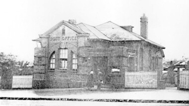
Photograph, Surrey Hills Post Office
... the City of Camberwell conducted a heritage study, (which still ...The post office opened at this location in 1912. It was demolished in 2000. Post office history in the area: Until 1883 when the railway came through to Surrey Hills, this was essentially a rural community of scattered farms. Land subdivisions soon occurred along the railway line and limited postal services followed soon after, although a ‘permanent’ home for the post office was two decades away. George Sim Junior is acknowledged as our first postmaster; he opened a post office on 1 October 1884 in his father’s general store at 619-621 Canterbury Road, a few doors down from the Surrey Hills Hotel on the corner of Union Road. Over the next 20 years, the Surrey Hills Post Office moved several times into temporary, shared accommodation – in 1889 into Woodhead’s Corner Store at 364 Canterbury Road; then in 1895 to No 376, Hansen’s Exchange Building, part of Hansen’s Terrace (demolished) and in 1901 to 109 Union Road, on the corner of Windsor Crescent. Following Federation in 1901, the new Commonwealth Government established the Postmaster-General's Department to provide postal services to the nation. Many of the post offices constructed in the following years reflected a growing sense of Australian pride and nationalism. It was 1914 when building commenced on the ‘purpose-built’ post office at 609 Canterbury Road, Surrey Hills. Described as “a polychromatic Federation Freestyle building”, it served as the local post office for nearly 85 years until sold by the Commonwealth Government in c1999, after which the post office moved to the current, less prominent site at 100 Union Road. For nearly 10 years under private ownership, the building was successfully adapted for use as the base for two businesses, Gargoyles and Dragons and later the Surrey Sculpture Studio, and fortuitously the historic integrity of the building was maintained. However although renovated in the 1990's, structurally sound and of historic significance, it was not protected under local or commonwealth heritage legislation and was demolished soon after sale. This is an early image of a demolished building which should have been protected. In 1991, when the City of Camberwell conducted a heritage study, (which still informs the basis of the City of Boroondara’s heritage guidelines for this part of the municipality,) the post office was owned by the Commonwealth Government. As such, it could not be considered for heritage listing by the local authorities. Some years later, the Commonwealth and Australia Post rather belatedly recognized not only that post offices have heritage and social value, but also that the architecture of post offices as community buildings is important. A heritage management scheme was developed for the buildings they own or control under the Environment Protection and Biodiversity Act 1999. Unfortunately, the Surrey Hills Post Office had been sold and demolished before this was finally enacted in 2004. Black and white image, perhaps from a post card, of Surrey Hills post office at 609 Canterbury Road. The building is flanked by a picket fence. There is a woman, a dog and a man in front of the entrance. The man is in uniform - possibly a postal employee.post offices, canterbury road, businesses, surrey hills post office, surrey sculture studio, gargoyles and dragons -
 Surrey Hills Historical Society Collection
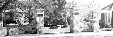
Photograph, View of Surrey Gardens looking east from Union Road
The 2 cannons in the gardens were acquired by Mr Arthur Brookes, popularly known as 'Empire Brookes'. They were from a British vessel used during the Crimean War and were originally placed in the grounds of the Guildford Road Recreation Oval. The Dimmick Gateway was erected in 1950 by the citizens of Camberwell in memory of Cr William Dimmick, JP, Mayor of Camberwell, 1935-1936 and a Councillor from 1934-1947. There is a photo of him in Mayoral robes in the City of Boroondara Library Service collection. Cr Dimmick was commonly called Roy.Black and white photo of the Dimmick Gateway in Surrey Gardens. The gateway is built as if it was designed to have a fence attached but there is none. There are 2 tall central pillars and an arched bridge to 2 smaller pillars. It appears to be constructed from a variegated slate material. There is a light on the top of each of the tall pillars and also a plaque. To the RHS of the photo is part of the Surrey Shrine, skirted by 2 cypress trees. A canon and the Memorial Cross can be seen between the gateway pillars and to the LHS of the photo the wooden bandstand can be seen.dimmick gateway, surrey gardens, surrey shrine, boer war, bandstand, parks and reserves, cr william dimmick, roy dimmick -
 Surrey Hills Historical Society Collection
Book, 15 to 21: the stuff that surrounds us, 2001
Produced as part of the City of Boroondara's Milennium record.A collection of photographic images produced by young people aged 15 to 21 capturing aspects of life in the City of Boroondara of importance to them.photography, boroondara, millenium project, 2001, (ms) elise baro, (mr) daniel hender, (ms) elizabeth gonsalves, (ms) jess bartlett, (ms) sophie basseghi, (ms) georgia biggs, (ms) teagan boscia, (ms) robyn bowden, (ms) jennifer grindrod, (ms) jo fraser, (ms) jessie fowler, (ms) michaela brown, (ms) melanie cass, (mr) damian corney, (ms) denise damianos, (ms) laura edwards, sam forsythe, yi ya huang, branka injac, (mr) daniel ippoliti, fintona girls school, methodist ladies college, balwyn high school, xavier college, camberwell high school, camberwell girls grammar, hawthorn secondary college, carey grammar school -
 Surrey Hills Historical Society Collection
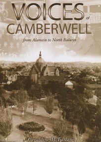
Book, Voices of Camberwell : Alamein to North Balwyn, 1999
A collection of interviews showing a picture of life in Camberwell in the first half of the century. Includes index and contributions from Surrey Hills, Lorraine Carrington, Charles Hausen and Jack McLean.A collection of interviews showing a picture of life in Camberwell in the first half of the century. Includes index and contributions from Surrey Hills, Lorraine Carrington, Charles Hausen and Jack McLean.Top rh corner of the title page Sue Barnett Centre of title page - Geraldine McFarlaneinterviews, (mrs) lorraine carrington, camberwell, (mr) charles hausen, surrey hills, history, (mr) jack mclean, wildlife sanctuary, social life and customs, vines timber yard, anecdotes, norfolk road, scouts, canterbury road -
 Surrey Hills Historical Society Collection
Book, Early Canterbury, 1994
... Camberwell City Libraries... Camberwell City Libraries Gwen McWiilliam ...This booklet gives a brief description of the local settlement in Canterbury giving the landholders names and name of the house (before street numbering was introduced) and street it was located in.This booklet gives a brief description of the local settlement in Canterbury giving the landholders names and name of the house (before street numbering was introduced) and street it was located in.canterbury, (ms) jane f portingale, postmistress, (mr) arundel wrighte, wood brothers, koonung creek, (mr) thomas power, (mr) oliver russell, (mr) frederick griffin, (mr) thomas payne, shrublands, w creek, (mr) john gardiner, (mr) james shanley, (mr)robert hoddle, (mr) michael logan, (mr) patrick moloney, (mr) hugh glass, r. larkins, t. hassett, e. sturt, d.s. campbell, (mr) joseph camm, riversdale road, w. logan, rochester road, 1843, trees, mont albert road, a. sikes, (mr) william smith, 1853, (mr) ernest carter, dentist, elgar's surrey, hindson family, (mr) george granville mercy, (mr) alfred golding, (mr)alexander patterson, (mr) thomas boanas, (mr) thomas hyde, builders, (mr) richard terrill, architects, (mr) thomas miles, drapers -
 Surrey Hills Historical Society Collection
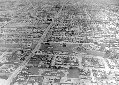
Photograph - Aerial view Riversdale Heights Estate area, c1923
This was probably part of a real estate promotion for the sale of the Riversdale Heights Estate. This was subdivided by Messrs. Duncan and Weller. Of the allotments offered, 30 were sold and realised £4600. Date of this sale was c December 1923. This suggests that the date This are was one of the last pieces of former rural land to be sub-divided for housing in Surrey Hills.The land between it and South Surrey Park was sub-divided post WW1, hence the naming of the streets after sites of WW1 battles.A black and white reproduction of an aerial photo of the area near the corner of Warragul and Riversdale Roads looking west towards the city. Some features have been identified by name including the Riversdale Heights Estate, which was being sub-divided. North and South Courts are shown. Other roads (unmarked) in the foreground are Graham Street, Allie Street, Thistle Street, Lille Street, Amiens Street, and Marne Street. Beyond these is the area marked 'PARK' (South Surrey Park), which is devoid of vegetation. Areas of Camberwell and Canterbury are also shown. The area covered extends to beyond St Dominic's Church. The original is mounted on a cream deckle-edged paper.Beneath the original on the mount: "SOUTH SURREY HILLS LOOKING WEST c. 1936" [The reference to the sale in the Box Hill Reporter of December 1923 found on Trove suggests that this date is not accurate.] Rear top LH corner of original in Jocelyn Hall's handwriting: "For Centre / from Mr James Long"riversdale heights estate, riversdale road, allie street, south surrey park, lille street, thistle street, amiens street, marne street, south court, north court, duncan and weller, real estate sales, graham street, st dominics church, highfield park, canterbury primary school, aerial photo -
 University of Melbourne, Burnley Campus Archives
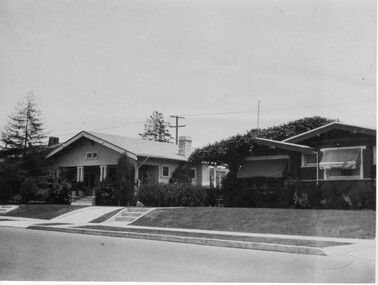
Photograph - Black and white print, Camberwell City Council, Two Suburban Houses, 1930
... Camberwell City Council... print Camberwell City Council Stuart Tomkin ...Note by T.H. Kneen 24 June 1992, "B91.424 and 425 are paired to show effect of lowering road level and consequent adjustment to access to the houses photographed. The handwriting is Mr. Jessep's."Black and white photograph. The front of 2 suburban houses. No front fences.suburban house, a.w. jessep, landscaping -
 University of Melbourne, Burnley Campus Archives
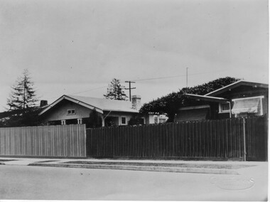
Photograph - Black and white print, Camberwell City Council, Two Suburban Houses, 1930
... Camberwell City Council... Suburban Houses Photograph Black and white print Camberwell City ...Note by T.H. Kneen 24 June 1992, "B91.424 and 425 are paired to show effect of lowering road level and consequent adjustment to access to the houses photographed. The handwriting is Mr. Jessep's."Black and white photograph. The front of the same 2 suburban houses as B91.424. The nature strip has been lowered to the same level as the road and each has a wooden paling front fence.suburban house, a.w. jessep, landscaping -
Canterbury History Group
Photograph - Canterbury Gardens, 1958 and 1961, 1958 and 1961
... melbourne Canterbury Canterbury Road Canterbury Gardens Camberwell ...Photocopies of four photographs taken in the Canterbury Gardens in 1958 and 1961.The 1961 photographs relate to a Camberwell Scouts Own Service , 19 February, but the 1958 photographs are not labelled.canterbury, canterbury road, canterbury gardens, camberwell scout group, scout groups, city of boroondara -
Canterbury History Group
Document - The foundation of our city, Renwick, Reg, c1973
A paper read to Camberwell Historical Society by Mr Reg. Renwick describing the part played by the Boroondara Road Board in the development of Camberwell and surrounding areas.4 foolscap pagescanterbury, camberwell, kew, hawthorn, boroondara road board, roads, tollhouses, palmer> sir james, affleck> john, box> henry, brooks> thomas, lavis> george, lynch> mkichael, pettett> william henry, stobie> david, wade> william henry, walsh> henry sellars, withers> john -
Canterbury History Group
Letter - Camberwell Honor Roll relocation, 1/02/2015 12:00:00 AM
Memorandum sent from the City of Boroondara notifying the residents of the Canterbury Memorial Homes of the decision of council to remove the Honor Roll from the entrance of the homes where it had been erected after the demolition of the Soldiers' Memorial Hallcity of boroondara, canterbury, canterbury road, canterbury memorial home units, world war 1914-1918, soldiers' memorial hall, honour boards