Showing 486 items
matching kilometres
-
 Wodonga & District Historical Society Inc
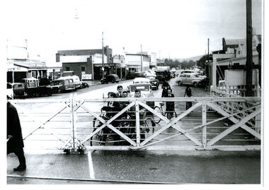
Photograph - High Street, Wodonga Level Crossing, 1954
This image is representative of many photographs illustrating the level crossing in the centre of Wodonga. Since its opening in 1873 the railway line had crossed High Street, originally called Sydney Road. It bisected the city with level crossing gates frequently stopping the flow of traffic and pedestrians as trains passed through. Signal Box B stood on the eastern side of the High Street level crossing and a big wheel closed and opened the gates. On 17th September, 1961, it was replaced by boom gates and flashing lights. The railway crossing was removed from High Street as part of the Wodonga Rail Bypass project. This involved a 5.5 kilometres bypass, the elimination of 11 level crossings and the relocation of the Wodonga station. It was moved from its original central location to a position on a new line on the northern edge of the town. The old station closed on 8 November 2008 and the new station opened on 25 June 2011.This image has local and statewide significance as it captures the former crossing in a major railway system. The railways played a critical role in opening up Victoria and connecting Australia for trade, business, social communication and transport.A black and white photo of the railway level crossing in High Street, Wodonga with gates closed. The Melbourne to Sydney railway line went through the centre of Wodonga and trains frequently held up internal vehicular and pedestrian traffic in the main street. railways wodonga, wodonga railway relocation, high st wodonga rail crossing -
 City of Greater Bendigo - Civic Collection
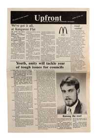
Newspaper, Shire of Marong, Upfront, c 1989
Marong was first incorporated as a road district on 27 August 1861, and became a shire on 23 December 1864. On 1 October 1915, the Borough of Raywood, which was gazetted on 17 January 1865 on 23.31 square kilometres of land 28 kilometres north of Bendigo was united with Marong. On 1 October 1990, the Shire of Marong became a rural city, under the Local Government Act 1989. In a report on 17 February 1994, the Local Government Board recommended that the five councils in the Bendigo region merge to form a "super city", with a population of about 81,000. Marong, Eaglehawk and Huntly had earlier objected to the proposal, and the Board noted a weak no vote against the merger proposal in a referendum in the region; about 70% had voted against, but with a turnout of between 30% and 40% of eligible voters. The three councils filed a writ in the Supreme Court, alleging failure to follow process by the Minister for Local Government, Roger Hallam, but by the time the new "super city" was announced, the writ had not yet been heard, and on 24 March 1994, the Rural City of Marong successfully applied for an injunction blocking the publication of the gazette the following day abolishing the five councils and appointing three commissioners. The government responded by introducing legislation, the City of Greater Bendigo Bill 1994, to Parliament, to effectively override the Supreme Court action, with Hallam saying "the bill would make clear that the Government is determined to achieve its objective for a more efficient municipal structure for the Bendigo region." Marong mayor Robert Hynes described the action as "terribly disappointing", adding, "One way or another, I believe it does mean an end to our fight... it seems the Government are above the law to me." On 6 April 1994, Marong voted to drop the Supreme Court action, effectively in doing so voting itself out of existence, and on 7 April 1994, the Rural City of Marong was abolished, and along with the City of Bendigo, the Borough of Eaglehawk and the Shires of Huntly and Strathfieldsaye, was merged into the newly created City of Greater Bendigo. On 29 April 1994, the Minister confirmed the Bill was not being proceeded with. https://en.wikipedia.org/wiki/Rural_City_of_MarongEight page newspaper style council newsletter providing community updates, news and information. shire of marong, city of greater bendigo amalgamation, councillor phillip eddy, rural city of marong -
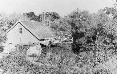
 The Beechworth Burke Museum
Photograph, Approximately 1930
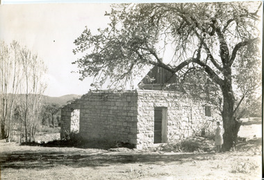
Taken in approximately 1930, this photograph depicts the ruins of Rosehill Dairy. A woman stands beside the ruins, observing them solemnly. The owner of this once prominent dairy, John Brewer, was born in Cornwall, England in 1832. After coming to Australia in 1849, Brewer worked in various forms of livestock transportation. Upon hearing of the vast discovery of gold in Victoria's north-east, he engaged in mining in the Ovens Goldfield district before starting his own dairy on Wooragee road (now Old Wooragee road). The Wooragee Valley, approximately five kilometres north of Beechworth, was used extensively during the nineteenth century to build farming practices in the area, possessing eighteen farms by 1860. Brewer enjoyed a prosperous career in the dairy industry, personally delivering milk to the residents of Beechworth. He died on the thirteenth of August 1915, a few weeks shy of his eighty-third birthday. As this photograph is dated approximately fifteen years later, it can be assumed that the dairy fell into neglect following his death. This photograph is historically significant as it provides insight the development of the dairy industry in Beechworth in the second half of the nineteenth century.Black and white square photograph printed on matte photographic paper Reverse: 1997.2912 / John Brewers / Rosehill / Dairy / top of the 'rising sun' /john brewer, 1930 beechworth, rosehill dairy, dairy industry beechworh, dairy factories beechworth, dairying, dairy farm beechworth, wooragee road, wooragee valley, old wooragee road, dairy farm ruins -
 Warrnambool and District Historical Society Inc.
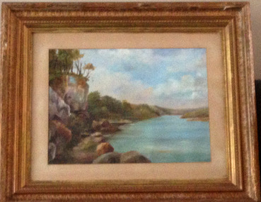
Painting, Hopkins River - Mary Norman - Clifton Banks
Clifton Banks is the name given to a bank on the Hopkins River Estuary, about one kilometre upstream from Proudfoots Boathouse. It is at the foot of the property, Clifton, which dates from 1850s. There are several works of art and photographs of Clifton Banks dating from the late 19th and early 20th centuries. Mary Norman (later known as Mary Norman=Bail) came to Warrnambool in 1901, residing with Canon and Mrs McGeorge. She studied art with Samuel Pearce Fuller and later taught art at Fuller's studio and at a local private school. She produced several seascapes and landscapes while she was in Warrnambool, leaving the town in 1905. She devoted the rest of her life to art as an artist and teacher. In 1922 she married Jess Bail. This art work of Clifton Banks won first prize at the 1902 Annual Ararat Art competitions. It was reported at the time that the work was not a copy but had been drawn from nature. The Warrnambool and District Historical Society has five of Mary Norman-Bail's art work.This is a most significant item as it is one of Mary Norman's art works and she was known in the early 20th century as a competent artist and a member of the Victorian Artists' Society. This art work also has historical significance as one of a number of Clifton Banks representations still surviving. Mary Norman also had an impact on the cultural life of Warrnambool during her short stay in the town. She also returned to teach in the town several times for short periods during the summer vacation times.This is a water colour mounted on art board and with a gilt framed and three outer layers of wooden gilded ornamental frames. The sides of the frames are broken in places and the guided material is somewhat discoloured. There are Les O'Callaghan handwritten notes and some typed material on the back giving information on Mary Norman and the art work. The back is sealed with pasted paper and there are both string and wire attached for hanging the pictureBack of art work: 'Diamond Bros, Photo Enlargers, Importers of Mouldings, Mounting Boards, Albums, Mirrors etc, Picture Framers. Mount Cutters and Plush Workers, Studio - 27 Bridge Road, Melbourne, Factory- 45 and 47 Duke Street, Richmond, Armstrong Street, Ballarat, Pirie Street, Adelaide, Brisbane, & Freemantle W.A.'mary norman, clifton banks, warrnambool -
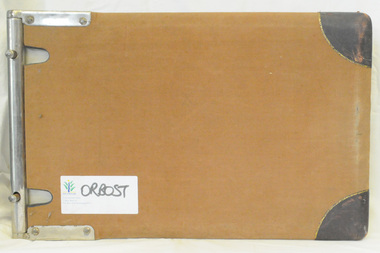
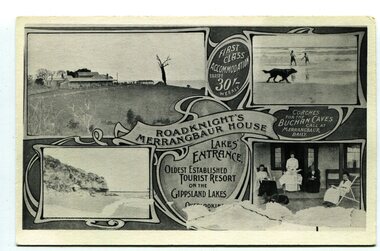 Orbost & District Historical Society
black and white postcard, C1910
This an advertisement / souvenir for Merrangbaur House in Lakes Entrance. Merrangbaur was in , Lakes Entrance and stood on the on the Prince's Highway, about a kilometre from Lakes Entrance. It was destroyed by fire on the early morning of December 15, 1935. The original residence of the Roadknight family, the first white settlers in the Lakes Entrance district, Merrangbaur House had been conducted as a guest house for many years. Much of the furniture was lost, although a portion of the building, consisting of the ballroom and several bedrooms, was saved Mrs. Anne McInnes, aged more than 80 years, the mother of the proprietress, Miss McInnes, was the only guest sleeping in the house when the fire began and had to be assisted from her blazing bedroom on the ground floor. She was carried through a window by members of the fire brigade and spent the remainder of the night at the house of a friend. Miss McInnes was in Melbourne on a business visit arranging for Christmas bookings, when she was informed of her loss. (info. from The Argus Melbourne Monday December 16 1935)This item is associated with tourism in East Gippsland in the early 20th century.A black / white photograph / postcard.There is a photograph of a Lakes Entrance scene in each corner with a banner for "ROADKNIGHT'S MERRANGBAUR HOUSE' in the middle.In a circle is "FIRST CLASS ACCOMMODATION TARIFF 30/- WEEKLY". It has a note that "Coaches for Buchan Caves call at Merrangbaur daily".merrangbaur-lakes-entrance roadknight-lakes-entrance postcard-lakes-entrance -
 Orbost & District Historical Society
ledger, POUND KEEPERS BOOK ORBOST COUNCIL, mid 20th century
This ledger was used by the Shire of Orbost pound keeper from 15 june 1947 -12 June 1971. The item was donated to Orbost & District Historical society from P.R.O.V. as a Place of Deposit (POD) item for safe keeping by a local history group or museum. The shire covered an area of 9,347 square kilometres and existed from 1892 until 1994 when it became part of the East Gippsland Shire Council. Orbost was at first included in the Bairnsdale Shire from 1882 and was later part of the Tambo Shire. Because of travelling distances the Croajingalong Shire was created in 1892 (name changed to Orbost Shire 17.2.1893 with James Cameron as the first Shire President. In 1994 it amalgamated to become part of East Gippsland Shire Council. This book records the impounding of animals which have been found wandering on local roads or trespassing on land. Many are farm animals. Impounded animals were either claimed by their owners after payment of a fee or if unclaimed , they were sold. The Orbost Pound was situated on Martin Street.This book is a record of a practice which was necessary to remove stock which were wandering on local roads or trespassing on neighbours. It contains many local names and is of social interest. (ref. Vic. Collections)A rectangular hard cover leather bound ledger with fawn cloth spine, titled "POUND KEEPERS BOOK SHIRE OF ORBOST". Inside the back cover are several sales dockets and Shire of Orbost By-Law No 48. Pages are lined in blue and red and pages are headed in black . Entries are hand written in blue and black. The entries give particulars of the animal impounded and where found with name of council officer and owner, if known.orbost-pound orbost-shire-council -
 Orbost & District Historical Society
cash book, 1905 - 1914
This ledger was used by the Shire of Orbost pound keeper from 1906 - 1914. The item was donated to Orbost & District Historical society from P.R.O.V. as a Place of Deposit (POD) item for safe keeping by a local history group or museum. The shire covered an area of 9,347 square kilometres and existed from 1892 until 1994 when it became part of the East Gippsland Shire Council. Orbost was at first included in the Bairnsdale Shire from 1882 and was later part of the Tambo Shire. Because of travelling distances the Croajingalong Shire was created in 1892 (name changed to Orbost Shire 17.2.1893 with James Cameron as the first Shire President. In 1994 it amalgamated to become part of East Gippsland Shire Council. This book records the impounding of animals which have been found wandering on local roads or trespassing on land. Many are farm animals. Impounded animals were either claimed by their owners after payment of a fee or if unclaimed , they were sold. The Orbost Pound was situated on Martin Street.This book is a record of a practice which was necessary to remove stock which were wandering on local roads or trespassing on neighbours. It contains many local names and is of social interest. (ref. Vic. Collections)A ledger with a black cover, brown binding. The page edges are marbled. It contains hand-written records of payments received by the treasurer of the Orbost Pound.on spine : inside a red box in gold lettering"Pound Cash Book" inside a black box in gold lettering"Shire of Orbost"orbost-shire-council orbost-pound accounts cash-book -
 Otway Districts Historical Society
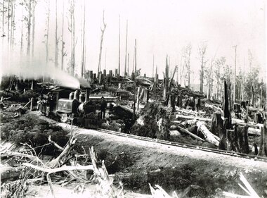
Photograph, Victorian Railways, Between Devitt Bros. Siding & Ditchley, 1901, 1901
Construction of the Colac-Beech Forest railway line began in 1900 with about 100 men engaged in laying and ballasting the track, as well as others forming the earthworks and building culverts and bridges. The result of this labour saw the railway advance from Colac until it climbed a spur hugging the side of a forty degree slope emerging on top of the ridge at Beech Forest. This photograph was taken 28 miles (45 kilometres) from Colac between Devitt Bros. Siding and Ditchley, just out of Beech Forest. Two 2-6-2 Tank engines of the narrow-gauge A class built by Victorian Railway's Newport workshop, were commonly dubbed 'Coffee Pots'. As well as pulling a load of NQR wagons a NBB saloon car ended the train. The devastation to the standing timber was deliberate: the Engineer-in-Chief of VR ruled that all trees within a certain distance of the railway line were to be cut down. This certainly saved the line from destruction several times in the future.B/W. An NA class locomotive, NQR wagons and an NBB saloon car, all with workmen, going around a bend between Devitt Brother's Siding and Ditchley on the Beech Forest line in 1901.beech forest; ditchley; devitt bros siding, railways; -
 Eltham District Historical Society Inc
Audio - Audio Recording, David Taylor, Dr Andrew Lemon and Irene Kearsey - Public Records Office Victoria, 12 Aug. 2023
EDHS Newsletter No. 271 August 2023 Public Record Office Victoria (PROV) is the Archive of the State Government of Victoria. Established fifty years ago under the Public Records Act 1973, PROV at the Victorian Archives Centre in North Melbourne now holds around 106 kilometres of public records from 1836 to the present day. There are also PROV collections at Ballarat, Beechworth, Bendigo, Geelong and the University of Melbourne. Our next meeting will be about PROV and former PROV staff member Andrew Lemon, will briefly reminisce about his work there, in it’s early days. As Assistant Director Access Services at PROV, David Taylor oversees the management of, and access to, the State collection. David will be outlining PROV’s unique role in Victoria, the nature of the public records it holds and how researchers can use increasingly sophisticated online resources to discover more about their ancestors and Victorian history. Finally, our Society member Irene Kearsey will talk about her experiences as a long-time volunteer at PROV.1:21:12 duration Digital MP3 file; 27.8MBaudio recording, eltham district historical society, meeting, society meeting, eltham, david taylor, dr andrew lemon, irene kearsey, public records office victoria (prov) -
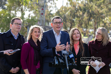 Eltham District Historical Society Inc
Photograph, Peter Pidgeon, Victorian Labor Government Press Release announcing planned upgrades to Hurstbridge line rail services and protection of historic Railway Trestle Bridge, Panther Place, Eltham, 1 August 2018, 1 Aug 2018
Announcement by Premier Daniel Andrews, Minister for Public Transport, Jacinta Allan and Member for Eltham, Vicki Ward mad alongside the Eltham Railway Trestle Bridge. MEDIA RELEASE "More Trains And Fewer Delays On The Hurstbridge Line" https://www.premier.vic.gov.au/wp-content/uploads/2018/08/180801-More-Trains-And-Fewer-Delays-On-The-Hurstbridge-Line-1.pdf Commuters on the Hurstbridge line will have more trains, more seats and fewer delays with a re-elected Andrews Labor Government to continue its massive upgrade of the Hurstbridge line. The Andrews Labor Government said it would deliver locals in Melbourne’s north-east more peak hour train services and less time stuck at boom gates, and we have. The first stage of the Hurstbridge Line Upgrade has been delivered – six months early and on budget. This includes the new Rosanna Station, duplicated track between Heidelberg and Rosanna and the removal of the dangerous level crossings at Alphington and Rosanna. There’s more to do and only Labor will deliver the next stage of the Hurstbridge Line Upgrade to give local commuters more train services and a more comfortable commute. The $530 million project will include a brand new train station at Greensborough and the duplication of three kilometres of track between Greensborough and Montmorency, and 1.5 kilometres of track between Diamond Creek and Wattle Glen to allow more train services during the morning peak. This will allow trains to run every six and a half minutes at Greensborough, every 10 minutes at Eltham and Montmorency, and every 20 minutes at Hurstbridge, Diamond Creek and Wattle Glen – as well as two extra Hurstbridge express services. Locals on the Labor Government’s new Mernda line will also get five extra train services during the morning peak, with a major upgrade of the Clifton Hill junction where the Mernda and Hurstbridge lines connect. Labor will also protect the Eltham Trestle Bridge – the last remaining timber bridge on Melbourne’s electric train network – which has local heritage protection and is an important part of the area’s character. The Liberals will leave this bridge to rot and demolish the nearby childcare centre and football club with their under-cooked and under-costed promise to upgrade the Hurstbridge line. Only Labor will protect this important piece of Melbourne’s history with planning work to be carried out for a long-term solution as part of the project. Stage two of the Hurstbridge Line Upgrade will create more than 950 jobs, with construction to start in 2020 and finish by 2022. Quotes attributable to Premier Daniel Andrews “We said we’d upgrade the Hurstbridge line and remove dangerous and congested level crossings at Rosanna and Alphington and we did – but there’s more to do.” “Only Labor will deliver the next stage of the Hurstbridge Line Upgrade with a new Greensborough Station and more trains, more often.” Quote attributable to Minister for Public Transport Jacinta Allan “The former Liberal Government promised new train lines but didn’t deliver a single kilometre of track – now they’re promising a half-baked upgrade of the Hurstbridge line with rubbery figures that don’t add up.” Quote attributable to Member for Eltham Vicki Ward “As a fifteen year old hopping on Red Rattlers at Eltham I wanted to do something to make the Hurstbridge line better. It’s taken me a few decades but finally our line will offer the frequency of services that are expected and needed in a 21st century city.”Born digital image (qty 27)jacinta allan, minister for public transport, panther place, premier daniel andrews, press announcement, railway line construction, trestle bridge, vicki ward mp for eltham, victorian parliament -
 The Beechworth Burke Museum
Photograph, Unknown c.1930s
This image shows Bethanga Bridge, which was constructed between 1927 and 1930 in Albury, NSW. The bridge was a necessity due to the building of the Hume Dam (Wier), 1919-1936. Bethanga Bridge is a long, nine-span, riveted-steel, variable depth, Pratt Truss road bridge of nine principal spans of 82 metres and a total length of 752 metres over the flooded valley of the Murray River, now part of Hume Reservoir. Because of its unique location, over the waters of a dam with the border running down the centre of the body of water, the Bethanga bridge is the only built structure shared by both New South Wales and Victoria. It was built 1.6 kilometres upstream of the dam and in 1961 was raised 300mm, with a concrete deck replacing the original wooden deck. The State Rivers and Water Supply Commission of Victoria and the New South Wales Department of Public Works were responsible for the construction works for the Hume Weir under the River Murray Waters Agreement. It is apparent that a similar joint arrangement was made for the construction of the Bethanga Bridge as part of the Hume Weir works.This photograph of the Bethanga Bridge is of historical significance as it showcases the architectural skills of Percy Allen and Vincent Packer. Additionally, it reveals the environmental landscape of the 1920s-1930s, is linked to the Hume Dam and both New South Wales and Victorian heritage. Unmounted black and white rectangular photograph. Reverse: 1997.3196 84-20-3bethanga, bethanga bridge, hume dam, pratt truss, murray river, hume weir, transportation -
 Eltham District Historical Society Inc
Photograph, Willis Vale on the north bank of the Plenty River, Church Street, Greensborough, c.1950
Photo sourced from Heidelberg Historical Society reproduced on p63 of The Diamond Valley Story by Dianne H. Edwards, Shire of Diamond Valley 1979. "Willis Vale, Greensborough, situated on the north bank of the Plenty River at the end of Church Street. The home wasa built about 1840 by Jame Willis Mayger from bricks hand-made nearby. It was later passed to the Partington family and when this photo was taken the building was deserted. Vandals and finally a bushfire destroyed Willis Vale in the 1950s." Greensborough Historical Society has same image with more accurate information on the date/cause of fire damage https://victoriancollections.net.au/items/585b6c96d0ce2c1268f1c96b "House built by Edward Maygar, Robert Whatmough lived there mid 19th century and later sold to Partington family. It was located on the Plenty River at Partington's Flat Greensborough. The derelict Willis Vale house was destroyed in 1964 when a fire originating from North Plenty Gorge - Kurrak Road - was lit by two teenage boys and made its way several kilometres down to Partington's Flat Greensborough."Black and white copy of photo printed on glossy photographic paper 30.5 x 40.5 cm (12 x 16 inch); image size approx. 18.5 x 28 cmchurch street, diamond valley story, greensborough, james willis mayger, partington family, willis vale -
 Orbost & District Historical Society
ledger, late 1950's - 1970's
This ledger was used by the Shire of Orbost in the late 1950's - 1970's.The item was donated to Orbost & District Historical society from P.R.O.V. as a Place of Deposit (POD) item for safe keeping by a local history group or museum. The shire covered an area of 9,347 square kilometres and existed from 1892 until 1994 when it became part of the East Gippsland Shire Council. Orbost was at first included in the Bairnsdale Shire from 1882 and was later part of the Tambo Shire. Because of travelling distances the Croajingalong Shire was created in 1892 (name changed to Orbost Shire 17.2.1893 with James Cameron as the first Shire President. In 1994 it amalgamated to become part of East Gippsland Shire Council. The Country Roads Board was the government authority for the construction and maintenance of main roads in Victoria between 1913 and 1983. It was succeeded by the Road Construction authority on 1 July 1983 and later merged with the Road Traffic Authority on July 1 1989 to form the Roads Corporation. James Cameron, an Orbost farming pioneer and Member of the Legislative Assembly, fathered the Country Roads Board This item is a hand-written record of Orbost Shire Council accounts. It pre- dates computer records. The Shire of Orbost local council no longer exists having been absorbed by the East Gippsland Shire Council.A black ledger with wooden covers. It contains hand-written records of transactions between Orbost Shire Council and the Country Roads Board.bottom left corner - Orbost in black on a white East Gippsland Shire logoledger accounts shire-of-orbost country-roads-board -
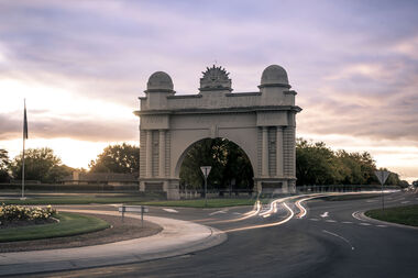 City of Ballarat
Public Artwork, Arch of Victory Monument, 1920
A grand cement rendered masonry structure of a single central arch flanked by wide piers 20metres in width, spanning the roadway, and 18 metres high. Crowned by the 'Rising Sun' symbol of the Australian Commonwealth Military Forces beneath which the words Avenue of Honour and Victory are written prominently across the arch. Erected in 1920, the Arch marks the beginning of s 22 kilometre stretch of 3728 trees, each one a memorial to men and women in order of enlistment for World War 1. On 2 June 1920, the Prince of Wales opened the Arch and was presented with a pair of silk pyjamas embroidered with Australian emblems. Each of the 500 'Lucas Girls' had put in a stich. The Arch of Victory, located at the entrance to the Avenue of Honour Ballarat, was erected in 1920 as a memorial to the people of the Ballarat and the surrounding district who enlisted in World War I. The Avenue of Honour, with the Arch of Victory, was officially opened by the Prince of Wales on 3rd June 1920. The single central arch is flanked by wide piers 20 metres in width, spanning the roadway, and 18metres high. The monument is of historical significance to the people of BallaratCement rendered masonry arch structureCrowned by the 'Rising Sun' symbol of the Australian Commonwealth Military Forces beneath which the words Avenue of Honour and Victory are written prominently across the arch.arch of victory, avenue of honour ballarat, australian commonwealth military forces, world war i, prince of wales, lucas girls -
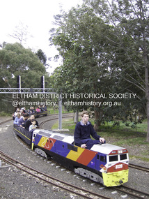 Eltham District Historical Society Inc
Photograph - Digital Photograph, Marguerite Marshall, Diamond Valley Railway, Eltham Lower Park, 7 September 2008
Kids of all ages enjoy the Miniature Railway. Published: Nillumbik Now and Then / Marguerite Marshall 2008; photographs Alan King with Marguerite Marshall.; p163 On Sundays in Eltham thousands of children, mums, dads and grandparents can be seen travelling around Lower Eltham Park in tiny trains. They are among the two and half million passengers who have travelled on the Diamond Valley Railway since it officially began in 1961. The miniature railway originally operated from the 1940s at Chelsworth Park, Ivanhoe, until flooding caused it to be moved to the Eltham Lower Park in 1959. The railway is modelled on the 1920s era – the heyday of passenger rail travel – and the trains are built on a scale of two inches to the foot (1/6). Although not exact replicas, trains include models of the Spirit of Progress, Puffing Billy, The Overland, Dog Boxes, Vic Rail S class, G class and a NSW 81 Class. The three and a half kilometres of track is set amongst native plants and picnic areas. A friendly hoot or the clang of a bell occasionally punctuates the tranquillity as a train emerges from a treed bend with passengers excitedly waving to onlookers. For $3 the train takes you on a 13-minute two-kilometre ride. Passengers sit in single file in the narrow train, which clatters along tracks built to the scale of the Australian narrow gauge of three feet six inches (1.1m). These are used in Queensland, South Australia, Tasmania and Western Australia. Safety standards are stringently kept. Even before you buy a ticket notices tell you that you must wear closed shoes. You can even borrow these, and you are given a pair of socks for the ride! Blue-overalled volunteers check tickets, see you aboard, and drive the train. They are mainly retired men who can at last devote their time to what little boys dream of – playing with trains. Passengers are instructed in safe behaviour, then the station master waves a white flag and off we go. The guard sits at the back with his whistle and green flag at the ready. The winding track, fringed by native trees and bushes planted by volunteers, stands on crown land managed by Nillumbik Council. The train clatters along the track and crosses a bridge over a drain elevated by name to The Blow Fly Creek. We pass by Meadmore Junction at a speed of three kilometres an hour. Then on through a tunnel, accompanied by squeals of delight, and after a few moments of blackness, light glimmers at the end. On we go, past the original platform, along another route past busy Main Road through Pine Creek Station, over a bridge and through another tunnel with more screams of delight.Then a signal stops us before the ‘all clear’ to return to our original point of departure. The railway services its passengers – the largest number of any miniature railway in Australia – with a fleet including: six diesel locomotives, three steam locomotives, eight sets of passenger cars and one battery electric Dog Box set. Members also privately own 20 locomotives and powered carriage sets as well as four carriage sets.1 All the trains are stored on-site in workshops, sheds and a tunnel. The railway is entirely run by volunteers, so that all ticket money is used for maintenance and extensions, and some goes to local charities. Since 1991, the entire railway has been rebuilt, including an upgraded signalling system. About half of the 120 volunteer members are active with about 35 working each Sunday, and a dozen or so working every Wednesday. Members are trained to positions of station assistant, booking officer, train guard, train driver or signalman. Members construct new carriages and locomotives as well as maintaining track, signalling and rolling stock.This collection of almost 130 photos about places and people within the Shire of Nillumbik, an urban and rural municipality in Melbourne's north, contributes to an understanding of the history of the Shire. Published in 2008 immediately prior to the Black Saturday bushfires of February 7, 2009, it documents sites that were impacted, and in some cases destroyed by the fires. It includes photographs taken especially for the publication, creating a unique time capsule representing the Shire in the early 21st century. It remains the most recent comprehenesive publication devoted to the Shire's history connecting local residents to the past. nillumbik now and then (marshall-king) collection, diamond valley railway, eltham lower park -
 Bendigo Historical Society Inc.
Map - Laminated map of Lake Eppalock at full capacity. Map 'E'
John Perry Collection. Laminated map of Lake Eppalock at full capacity. Black and white. The dam was built by the State Rivers and Water Supply Commission of Victoria. The dam wall height is 45 metres (148 ft) and the main embankment is 1,041 metres (3,415 ft) long. At 100% capacity the dam wall was designed to hold back 304,651 megalitres (6.7014×10¹⁰ imp gal; 8.0480×10¹⁰ US gal) of water. The surface area of Lake Eppalock is 3,011 hectares (7,440 acres) and the catchment area is 2,124 square kilometres (820 sq mi). The controlled spillway is capable of discharging 8,040 cubic metres per second (284,000 cu ft/s). Lake Eppalock supplies both stock and domestic water to the Campaspe irrigation district. It also serves as a water supply to Bendigo and Heathcote and, in more recent times, Ballarat. The lake is a major attraction for those engaging in watersports, with a number of tourist parks and accommodation facilities available. Permissible activities on the lake include high-speed boating, water skiing, sailing, canoeing, fishing and swimming. The lake's water levels were low for approximately eight years between 2002 and 2010 during a prolonged drought, which restricted the amount of recreational activity until rainfall in the latter half of 2010 returned the lake to 100 percent capacity. Built between 1961 and 1964, Lake Eppalock remains the only water storage on the Campaspe River system.map, eppalock, water, dam, reservoir -
 Orbost & District Historical Society
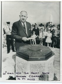
black and white photograph, April 20 1970
Sir Henry Bolte, premier of Victoria, renamed Cape Everard at Point Hicks during the Centenary of Cook's Landings on April 20, 1970. There is no land feature at Cook's coordinates of 38°0'S and 148°53'E, a point which lies several miles out to sea and under 50 fathoms of water. Captain Cook invented Point Hicks so that he could conceal Bass Strait and the insularity of Tasmania. The Admiralty had issued its usual instructions to hide strategically important discoveries that could become security risks. Captain Hicks was James Cook`s senior lieutenant. There has been some dispute as to whether Zachary Hicks actually saw Point Hicks or whether he saw Ram Head about 20 kilometres further up the coast. Although Cook named the promontory Point Hicks it was changed to Cape Everard in 1843.. In 1970 the Victorian government changed the name Cape Everard to 'Point Hicks'. It lies on dry land, about 22 nautical miles (41 km) northeast of Cook's phantom Point Hicks, where it preserves the story of Cook's first landfall in Australia. This is a contemporary pictorial record of a significant event in East Gippsland's history.A black / white photograph of a man in a suit making a speech with the audience standing behind him. He is standing in front of an octagonal-shaped directional marker set ointo a stone support. There is a policeman behind him. In the background to the right is a lighthouse.on front - "20th April 1970, Sir Henry Bolte renames C. Everard as Pt Hicks" handwritten in block letterscook-james-point-hicks cape-everard bolte-henry -
 Orbost & District Historical Society
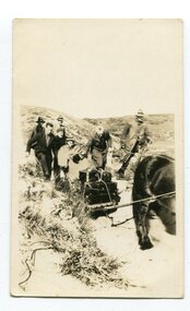
black and white photograph, first half 20th century
Access to the cottages at the lighthouse was difficult and the horse-drawn sled was in use until the 1940s. It was used to haul personal goods as wel as those needing medical attention at far-off Orbost. This photograph could be connected with the Gledhills in the 1930s when a medical emergency necessitated a removal to Orbost. Dr Nettleton was the doctor at Orbost at that time. (there could be a link through donor) Point Hicks is claimed to be Captain James Cook’s first sighting of mainland Australia. The lighthouse was built on the point during 1887 and 1888 and commenced operation in 1890, built from concrete and with timber keepers quarters. It was connected to mains electricity in 1965, and then to solar power recently. Originally access to Point Hicks was by sea. In 1920 a return trip, by land to Cann River, 47 kilometres away from the light station, took two days. By 1946 the journey had been reduced to 36 hours by a combination of horse and jeep. During the early 1950s it was still a 12-hour ordeal. The light no longer works, it was turned off 21 years ago and the Point Hicks lighthouse is now powered by a much smaller, more modern light. the lightkeepers' cottages are used for tourist accommodation.This photograph is associated with Point Hicks, a historically important lightstation in East Gippsland.A small black / white photograph of a horse dragging a sled with suitcases on it. There are seven people walking behind, one holding the reins. They are waalking through a sand dune.on label on back - "Bring Out to Light House keeper from Point Hicks"point-hicks-lighthouse -
 Orbost & District Historical Society
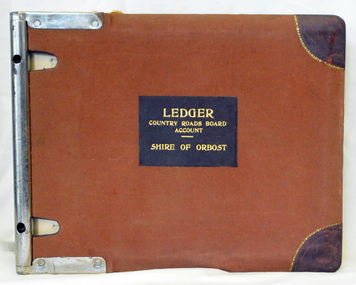
ledger, 1950's -1960's
This ledger was used bt the Shire of Orbost local government to record Country Roads Board accounts 1950's and 1960's. The item was donated to Orbost & District Historical society from P.R.O.V. as a Place of Deposit (POD) item for safe keeping by a local history group or museum. The shire covered an area of 9,347 square kilometres and existed from 1892 until 1994 when it became part of the East Gippsland Shire Council. Orbost was at first included in the Bairnsdale Shire from 1882 and was later part of the Tambo Shire. Because of travelling distances the Croajingalong Shire was created in 1892 (name changed to Orbost Shire 17.2.1893 with James Cameron as the first Shire President. In 1994 it amalgamated to become part of East Gippsland Shire Council. The Country Roads Board was the government authority for the construction and maintenance of main roads in Victoria between 1913 and 1983. It was succeeded by the Road Construction authority on 1 July 1983 and later merged with the Road Traffic Authority on July 1 1989 to form the Roads Corporation. James Cameron, an Orbost farming pioneer and Member of the Legislative Assembly, fathered the Country Roads Board. This ledger is a hand-written record of accounts for the Orbost Shire local council. It pre-dates computer records. The Orbost Shire Council no longer exists having been absorbed into the East Gippsland Shire Council.A heavy brown coloured ledger with covered wooden covers. it has steel metal binding. Inside are strips of paper marking pages. It contains blue ink hand-written records of monies in/out (?) to Shire of Orbost Council. On the front cover inside a black rectangle in gold print is " LEDGER COUNTRY ROADS BOARD ACCOUNT ORBOST". It is an "Emu Binder".ledger orbost-shire accounts country-roads-board -
 Orbost & District Historical Society
ledger, 1950's ; 1960's
This ledger was used by the Shire of Orbost to record transactions with the Country Roads board in 1950's and 1960's. The item was donated to Orbost & District Historical society from P.R.O.V. as a Place of Deposit (POD) item for safe keeping by a local history group or museum. The shire covered an area of 9,347 square kilometres and existed from 1892 until 1994 when it became part of the East Gippsland Shire Council. Orbost was at first included in the Bairnsdale Shire from 1882 and was later part of the Tambo Shire. Because of travelling distances the Croajingalong Shire was created in 1892 (name changed to Orbost Shire 17.2.1893 with James Cameron as the first Shire President. In 1994 it amalgamated to become part of East Gippsland Shire Council. The Country Roads Board was the government authority for the construction and maintenance of main roads in Victoria between 1913 and 1983. It was succeeded by the Road Construction authority on 1 July 1983 and later merged with the Road Traffic Authority on July 1 1989 to form the Roads Corporation. James Cameron, an Orbost farming pioneer and Member of the Legislative Assembly, fathered the Country Roads Board. This item is a hand-written record of accounts of the Orbost Shire local Government. It pre-dates computer records,The Shire of Orbost Council no longer exists having been absorbed into th East Gippsland Shire council.A heavy brown coloured ledger with steel bindings. Covers are probably wooden. It contains hand-written records of transactions the Country Roads Board. -
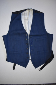 Warrnambool and District Historical Society Inc.
Textile, Fletcher Jones Man’s Shop, Waistcoat Fletcher Jones, 1946
This waistcoat was made for Mr Alan Vinnell by the Fletcher Jones Man’s Shop in 1946 and was worn by Mr Vinnell at his wedding in Lang Lang on 27/4/1946 to Miss Madge Ridgway. Alan was the son of Albert Vinnell and Ada Rose Wood. He attended school in Macarthur about 40 kilometres northwest of Warrnambool. The Fletcher Jones Man’s Shop was located at the corner of Liebig and Koroit Streets in Warrnambool. David Fletcher Jones (1895-1977) served in World War One and in the 1920s set up as a travelling hawker selling drapery in Western Victoria. In 1924 he leased three shops in Liebig Street and in 1928 he moved to the Koroit/Liebig Streets intersection with his Man’s Shop. He manufactured men’s clothing on site. In 1931 a new set of two-storeyed buildings was erected on the site and Fletcher Jones moved into the building. In 1946 a Fletcher Jones shop was opened in Melbourne and in 1948 a factory was established in Raglan Parade, Warrnambool with a new company, Fletcher Jones and Staff established in 1951. This company became known Australia-wide, firstly for the production of men’s trousers, and later men’s and women’s clothing. By 2011 the Warrnambool factory was sold and the company dissolved. This waistcoat is of historical interest as an example of the high quality work produced at the Fletcher Jones Man’s Shop in Warrnambool in the mid 1940s. The Fletcher Jones business became one of the most important ones in Warrnambool in the 20th century and the early 21st century.This is a sleeveless woollen waistcoat made of blue striped material with a black cotton backing. The back has two black cotton flaps with a metal buckle to allow for the tightening of the coat across the back. The inside is lined with a cream, yellow and grey striped cotton material. The waistcoat has one inside pocket with a button enclosure and four outside pockets. The waistcoat has six black buttons on the outside and a maker’s label stitched on the inside. ‘Fletcher Jones The Man’s Shop Warrnambool Mr A. Vinnell Date 15/2/46’fletcher jones man’s shop warrnambool, history of warrnambool, albert vinnell, vinnell -
 Warrnambool and District Historical Society Inc.
Document, Grasmere Church Dispute, 1882
These papers contain cuttings newspaper articles from the Standard of 1882 and handwritten comments appended to these cuttings. They refer to a dispute in 1882 regarding the ownership of the church in Grasmere to which the Anglican Church was claiming ownership The author of the handwritten comments is unknown but the comments purport to be a more accurate account of events than what appears in the paper cuttings. Grasmere is a small settlement 10 kilometres north of Warrnambool. In the 1850s land in Grasmere was donated for educational purposes and a Government-subsidized school which was a Denominational School run by the Church of England was established in 1858. This school was closed when Government State Schools were established after 1872 and the Anglican Church dismantled the old school and built a church on the site in the late 1870s. This church was erected by public subscription and many of the subscribers apparently believed they were donating to a building that could be used by any local Protestant churchgoers. The church in 1882 was being used by the Presbyterian Church for its services. A public meeting was held in 1882 to try to resolve the dispute between the Anglican Church claim and the local residents’ claim that the site belonged to the local community. Apparently the dispute remained unresolved and the Grasmere Anglican Church continued to operate until the early 20th century. This document is of interest as it is associated with a dispute that took place in Grasmere in 1882 and gives some indication of the arguments that were presented at the time in favour of, or opposed to, the Anglican Church’s claim to the ownership of the church. It is a document of particular interest to the history of the Grasmere. This is a folder of eleven foolscap-size sheets of paper enclosed in a mottle-coloured cardboard cover. The front cover is creased and partly torn and the back cover is detached and is in two pieces. The pages have been stitched together with thread and contain paste-in newspaper cuttings and handwritten material in purple ink. Grasmere Anglican Church -
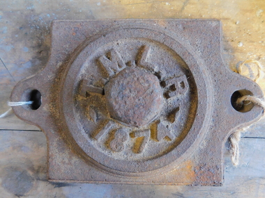 Puffing Billy Railway
Axle Box Cover - Tasmanian Main Line Co, 1874
Axle box cover from a Tasmanian Main Line Railway rail vehicle from 1874 The Tasmanian Main Line Railway Company (T.M.R.L.) was a privately owned railway company that existed in Tasmania from 1872 to 1890. The company were the first operators of rail services between Hobart and Launceston, where it connected with the Launceston and Western Railway (L.W.R.) It started construction of a 3' 6" gauge line between Hobart and Launceston in 1873 which was completed in December 1875. and was officially opened on 1 November 1876. The route of the railway was selected largely as a result of vocal local interests and accordingly traversed some reasonably unfavorable topography, particularly in the southern section. Because the TMLR had limited finances, the line was built to the narrow (1067 mm) gauge and included long sections of steep gradients and sharp curves. The final eighteen kilometres of the route from Western Junction to Launceston used the existing broad gauge alignment of the Launceston and Western Railway, with a third rail being laid for use by the narrow gauge trains A close but uncomfortable relationship with the Government was resolved in 1890 with the purchase of the company's assets by the Crown and their incorporation into the Tasmanian Government Railways on 1 October 1890. Historic early Tasmanian Main Line Railway - Vehicle Axel Box cover Axle box cover from a Tasmanian Main Line rail vehicle from 1874.T.M.L.R - 1874 -axle, tasmanian main line railway, axle box, tasmania, main line, -
 8th/13th Victorian Mounted Rifles Regimental Collection
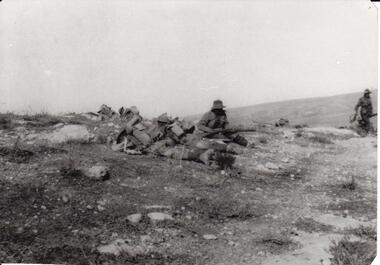
Photograph - 8th LH outpost, 1918 circa
The 8th Light Horse Regiment was engaged in the battle to capture Turkish defences at Tel El Khuweifle 16 Kilometres north of Beersheba from 1 to 6 November 1917. Other units were drawn from Imperial Camel Corps, British Yeomanry Division, New Zealand Mounted Rifles and 53 Welsh Division. The 8th Light Horse Regiment AIF was raised at Broadmeadows Victoria in September 1914 under the command of Lieutenant Colonel Alexander White and formed part of the 3rd Light Horse Brigade. The regiment served at Gallipoli where in a courageous but ill-fated charge at the Nek on 7 August 1915 it suffered horrendous casualties including Lieutenant Colonel White. Rebuilt in Egypt under the command of Lieutenant Colonel Leslie Maygar VC the regiment went on the serve throughout the Middle East Campaign. Colonel Maygar died of wounds at Beersheba when the regiment was attacked by enemy aircraft while waiting to follow up the successful charge of the 4th LH Brigade on 30 October 1917. The 8th Light Horse AIF was disbanded in 1919, but soon after re-raised as the 8th (Indi) Light Horse in the Citizen Military Forces, superseding 16th (Indi) Light Horse.Part of a rare collection of photographs of 8th Light Horse Regiment AIF during WWI (1914-1918).Black and white photograph of two soldiers of the 8th Light Horse Regiment AIF wearing slouch hats and armed with rifles. They are near three figures wearing helmets lying on the ground, possibly men of the Imperial Camel Corps or British infantry. Below photograph "Stony desert landscape known as Khuweilfe ( Thirsty Ridge ), 8 miles north of Beersheba. Only had a little water hence the name",tel el khuweifle, 8th, light horse, world war one, wwi -
 Eltham District Historical Society Inc
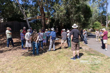
Photograph, Peter Pidgeon, Heritage Excursion: Woodridge Wander, 6 March 2021
The Woodridge Estate was a major residential subdivision that was developed in many stages in the 1970s and 80s. It extended easterly from the older residential area of Eltham into what had previously been largely privately owned bushland. The subdivision design took into account the steep topography and resulted in large blocks that enabled preservation of much of the tree cover. It included a number of small parks and walkways and the one kilometre long Woodridge Linear Park. A bushland area left as a proposed school site later became the Pauline Toner Butterfly Reserve for preservation of the rare Eltham Copper Butterfly. This walk explores some Woodridge streets as well as the linear park and butterfly reserve, a hilly walk of about 3 km and includes some moderately rough tracks. Permission to visit the external grounds of two private properties to view heritage listed houses not visible from the street was granted. The walk commenced at 2pm at the access to Woodridge Linear Park in Grove Street just east of the Eltham East Primary School (Melway ref 22 B4). This free walk was open to the general public as well as Society members. Whilst COVID restrictions did not require the wearing of masks in the open, masks had to be carried and all attendees registered with name and contct number.Born Digital (41 images)covid-19, eltham, eltham district historical society, heritage excursion, woodridge estate -
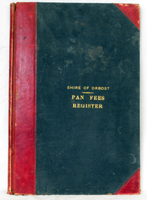 Orbost & District Historical Society
ledger, 1906
This ledger was used by the Shire of Orbost from 1906 to 1910. The item was donated to Orbost & District Historical society from P.R.O.V. as a Place of Deposit (POD) item for safe keeping by a local history group or museum. The shire covered an area of 9,347 square kilometres and existed from 1892 until 1994 when it became part of the East Gippsland Shire Council. Orbost was at first included in the Bairnsdale Shire from 1882 and was later part of the Tambo Shire. Because of travelling distances the Croajingalong Shire was created in 1892 (name changed to Orbost Shire 17.2.1893 with James Cameron as the first Shire President. In 1994 it amalgamated to become part of East Gippsland Shire Council. In Australian suburbs and rural towns where the sewer wasn't connected, people usually had an outside toilet. The toilet seat was made of a plank of wood secured at its ends to the walls of the building with a large round hole in the middle. Underneath was the removable sanitary pan and on a regular basis, usually weekly, the full pan was taken away and replaced with an empty one. This was the job of the sanitary carter. the sanitary depot was in Martins Lane, Orbost Development of the Orbost Wastewater Treatment Facility began in the 1960’s with the construction of four treatment lagoons. Shortly after the construction of the lagoons the sewerage system was installed throughout Orbost.This item is a record of accounting for the local government. The collection of sanitary pans was a necessary service before the Orbost township was had its own wastewater treatment facility.A large register of pan fees for the Shire of Orbost. A black hard cover book with red binding and marbled end pages. Entries are hand-written in black ink.On spine - "PAN FEES REGISTER: in gold lettering. In centre of front cover in gold - "SHIRE OF ORBOST (underlined) PAN FEES REGISTER"orbost-shire-council ledger-pan-fees sewage orbost-township-sanitary-service -
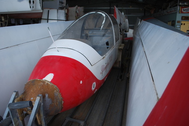 Australian Gliding Museum
Machine - Glider – Sailplane, 1967
The Slingsby T53 glider was designed by J. Sellars in the 1960s as an easily maintained two seat trainer suitable for RAF Air Training Corp use and for sale in the USA and Australian markets where wooden gliders were becoming less popular. The Slingsby T53 prototype first flew in 1967. The T53B version has a conventional fixed tailplane with elevator instead of the all-moving tailplane of the original type. The “B” version also has ailerons of narrower chord and lacks wing flaps. Further changes were made to the fin (extended above the tailplane) for the final “C” version. Production of the T53 at Slingsby was disrupted by a fire at the factory in 1968. As a consequence the contract to supply 40 of the type to the RAF was cancelled and only a relatively small number (possibly 27) were made by Slingsby before the project was discontinued. The rights were later sold to Yorkshire Sailplanes. It designated the glider as the YS53 Sovereign – only a few were produced (possibly 3). The Australian Gliding Museum’s example is a type “B” model. It bears serial number 1686 and was manufactured in 1967. It was registered in Australia as VH-GUB in name of Boonah Gliding Club, Boonah, which is about 90 kilometres south west of Brisbane in Queensland. Locally it was called “the Bomber”! This exhibit is a representative example of the Slingsby T53 sailplane type. It is a rarity in Australia.All metal twin seat glider / sailplane, painted white with red tips and markings.“Slingsby T53B” on each side of fuselage below cockpit opening; Registration VH-GUB on each side of fuselage at rear.australian gliding, glider, sailplane, slingsby, t53, sellars, boonah gliding club, slocombe, boyle -
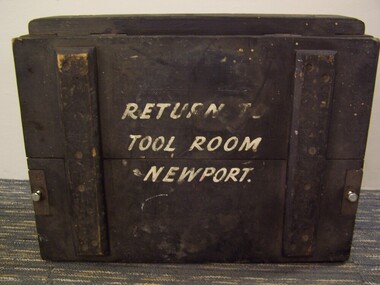 Puffing Billy Railway
Equipment - Flaman Speed Indicator and Recorder transport Box
Train Instrument transportation Box used for the transporting of Flaman Speed Indicator and Recorder to the repair workshops The Flaman Speed Indicator and Recorder was a device patented in 1901 by Nicolas Charles Eugène Flaman of France for indicating the current speed of a vehicle (for example a railway locomotive) and recording it on a paper tape that could be unrolled and examined at the end of a run to provide evidence of the speeds attained on the journey. Design features: The paper tape recording was driven directly by the wheels of the locomotive, with the paper spool moving at a fixed rate per kilometre travelled. Three graphs were recorded, the first being time elapsed (with the trace moving vertically if the train was stationary), the second being a speed curve. and the third recording the driver's attentiveness to signals ("Vigilance") by marking one tick above a line when the driver depressed a button, and another below the line when the engine went over the signal ramp. Data recorded: Read together, it was possible to determine exactly what speed the locomotive had been travelling at any point in time or distance. As well as allowing study of locomotive performance, it also allowed greater scrutiny of the observance of the driver of speed restrictions along the line and attentiveness to signals. It was practice on some railways such as the Victorian Railways in Australia for the driver to sign the speed chart prior to departure.Historic - Victorian Railways - Train Instrument transportation Box for the transporting of Flaman Speed Indicator and Recorder to the repair workshopsLarge wooden box with wrought iron fittings, painted black with white lettering on side panels. RETURN TO / TOOL ROOM / NEWPORTpuffing billy, train instrument transportation box, victorian railways, flaman speed indicator and recorder -
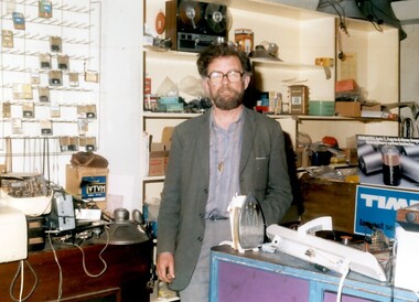 Surrey Hills Historical Society Collection
Photo, Henry Jamieson in his shop at 149 Union Road, Surrey Hills
Henry was a familiar persona in Union Road and around the Surrey Hills Neighbourhood Centre for decades. He lived all his life within 3 kilometres of his radio shop. Son of Catherine and ‘Mick’ Jamieson, Henry was born in 1927 in View Street, Surrey Hills and was educated at Box Hill Grammar School. His father died when he was young and Henry took a job as a technical assistant with the Commonwealth Film Unit. Film was a life-long interest and he became a longstanding member of CATHS (Cinema and Theatre Historical Society of Victoria). Henry also had a profound love of music which was reflected in his work and hobbies. He joined Adrian Knowles, who had started his radio shop at 149 Union Road in the 1940s, and trained at RMIT as a radio tradesman. In time Henry took over the business. When 3MBS established in Kew, Henry was an enthusiastic supporter and volunteer. For some years Henry and a co-producer presented a prime time Saturday evening programme 'Bach to Bernstein'; later his distinctive voice could be heard in the early morning time slot, 'Daybreak'. Henry was also a staunch supporter of the Surrey Hills Historical Society and served as its President for a number of years. Henry died in 2011. Colour photo of a bearded man inside a shop with an assortment of radio and electrical appliances and components.knowles radio, surrey hills neighbourhood centre, union road, surrey hills historical society, cinema and theatre historical society of victoria, 3mbs radio, henry jamieson, adrain knowles -
 City of Greater Bendigo - Civic Collection
Ceremonial object - Eaglehawk Bell, unknown
The Borough of Eaglehawk was a local government area which covered the northwestern suburbs of the regional city of Bendigo and covered an area of 14.54 square kilometres (5.6 sq mi). Eaglehawk was first incorporated as a borough on 29 July 1862. It had nine councillors, who represented the entire borough. Councillors met at the Town Hall (incorporating the Star Cinema) at the intersection of Sailors Gully Road and Loddon Valley Highway, Eaglehawk. The Town hall has always been the centre of the Borough's activities and was built in 1901 on the site of an earlier town hall which had stood on the location since 1865. The Victorian Heritage Database notes: "The present building replaced this earlier building and was opened on 14 August 1901. The architects were the Melbourne firm of Wilkinson and Permewan. As a much larger and more sumptuous building of brick and stone featuring a central clock tower, the new hall reflected prevailing architectural fashion and was a remarkable investment for a town consisting predominantly of poor mining families. The condition of the town hall is substantially as built. The design is almost identical to the Castlemaine Town Hall." On 7 April 1994, the Borough of Eaglehawk was abolished, and along with the City of Bendigo, the Rural City of Marong and the Shires of Huntly and Strathfieldsaye, was merged into the newly created City of Greater Bendigo.Brass bell with eaglehawk topper / handle on timber stand. The lower front section of the topper has the Borough of Eaglehawk seal attached. No hallmarks or makers stamps visible.borough of eaglehawk, star cinema