Showing 1053 items matching " train line"
-
 Eltham District Historical Society Inc
Photograph, Upper Yarra Dam, Spring Tour, 22 Oct 1995, 22/10/1995
EXPLORING THE UPPER YARRA (Newsletter No. 105, November 1995, by Bettina Woodburn) We enjoyed the Spring Excursion, this year "Exploring the Upper Yarra" - in spite of the constant rain and the countryside under the cloud cover, especially in the valleys, being mainly shiny shades of green. The occasional fields of buttercups, clumps of arum lilies and splendid rhododendron and other flowering bushes became very special. The Cobb and Co coach was warm and a cosy retreat as we zig-zagged on the highways and byways to glimpse the Yarra River, upstream and down, its secret places, and particularly the many bridges. Russell excelled as 'Poet Laureate', reading from Dacre Smyth's book. This 1979 publication includes paintings of all the bridges along the river with poems and brief descriptions of each one. Some of the bridges are in out of the way places and are not very well known. We looked forward to hearing the poetry as much as seeing the ' constructions'…Big Pat (was he short or tall, lean or fat? He did win the two hundred pound reward for discovering gold and had the creek named after him), about the 'Eddies'?, and the disliked 'meccano' bridge in Warburton, etc. etc. The hot roast lunch in the old Reefton Hotel was also most welcome. It was easy to imagine it peopled by miners and early settlers. Starting by crossing the new (1974) concrete bridge at Warrandyte we headed through Wonga Park with views to the Christmas Hills and to the escarpment of the Yering Gorge, which causes flood waters to back up through the Yarra Glen plain, so avoiding disasters downstream. At the end of a long driveway we found the wooden, privately owned Henley Bridge (1935 after the 1934 floods). This facilitates access to different parts of Henley Farm and to Lilydale. Everard Park, named after Blanche Shallard's father, a State Member for 17 years, below the Highway Yarra crossing was in need of care. It is 10 miles from Yarra Glen by road but, as "Yarra Marra” canoeists well know, 32 winding miles down by water. After more delightful countryside scenes we joined the Warburton Highway at Woori Yallock. From the old Railway Station at Launching Place the Centennial Trail for walkers, cyclists and ' horse riders has replaced the rails. The line from Lilydale was opened in 1901, and the last diesel freight train ran to Warburton in 1965. It continued to rain as we had morning tea in Warburton in a shelter between footbridges. From here we continued upstream past the Bridge to O'Shannasy Lodge and Reservoir, Starvation Creek, and the Peninsular tunnel (miners dug it as at Pound Bend) which we visited (scrambling down those steps!) on our return after lunch. Our furthermost point was the Upper Yarra Dam Reserve (and vast catchment area). Finished in 1957 after ten years work and 100 years after Yan Yean, it supplies much of Melbourne's water. After crossing the 30m Launching Place Bridge to the Eltham side of the Yarra and Healesville, we saw in the distance the Yarra Glen Timber Trestle Bridge over the river flats "the longest for years in the land it was said!" Harry's dream of "better weather over the Divide" unfortunately didn't come true, but I'm sure we 36 members will retain happy memories of a day that was wet and green and filled with Bridges. Bettina Woodburn - October 1995 Record of the Society's history of activities - Spring 1995 excursionRoll of 35mm colour negative film, 4 of 5 stripsKodak Gold 400-5shire of eltham historical society, activities, upper yarra dam, henley bridge -
 Eltham District Historical Society Inc
Photograph, The Weekly Times, Opening of the Heidelberg-Eltham Railway Line, 6 June 1902, 1902
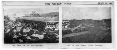
Reproduced from "The Weekly Times", 14th June 1902, page 10. 06 Jun 1902 Cross Reference Photo No.(s): 602, 604 Source: La Trobe Library and National Library, Canberra THE HEIDELBERG TO ELTHAM RAILWAY. OPENING CEREMONY. The opening of the railway line from Heidelberg to Eltham took place on the 6th inst. The special train, containing a large number of members of Parliament, including Mr Trenwith, the Minister for Railways, left Prince's Bridge at half-past eleven, and arrived at Eltham at twenty minutes past twelve. The party was accompanied by Mr Fitzpatrick, Acting Commissioner for Railways; Mr Lockhead, the Traffic Manager; and Mr Norman, Engineer for Existing Lines. On arrival, the visitors were entertained at a banquet in the marquee, of which a photograph is given, erected close to the railway station. Mr E. H. Cameron, M.L.A., the member for the district, occupied the chair, and, seated on his right, was Mr Mason, the Speaker of the Legislative Assembly, and on his left the Minister of Rail-ways. After the banquet His Excellency the Governor-General arrived, and was received and welcomed by Mr Cameron, the local State school children singing the National Anthem. The Governor-General, in declaring the line open, said that he felt highly honored at being asked to perform the opening ceremony, and he trusted that the railway would be a source of great convenience to the inhabitants of the district. He was sorry to say that this would be the last opportunity he would have of seeing them. It cost him a great deal to leave them. (Hear, hear.) He had a great many friends amongst all sections of the community, and he could hardly bear to trust himself to speak about leaving them. (Hear, hear.) He was sorry Lady Hopetoun was on the high seas, and unable to accompany him that day. Mr Cameron thanked his Excellency for performing the opening ceremony, and hoped the trip home would have the effect of restoring His Excellency to good health again. In replying. Lord Hopetoun thanked them sincerely for the cordial vote of thanks. He hoped Providence would shower her blessings over them, and that they would have a series of good seasons. He would always keep a warm corner in his heart for the people of Victoria. (Loud cheers.) THE COUNTRY. In our illustrations, views are given of a couple of sections of the new line, and glimpses of the surrounding country are shown. The line is eight miles in length, and cost £51,000 in construction. Eltham, which is the terminus, possesses many of the features that go to make a favorite holiday resort. It is a quiet picturesque little hamlet, snugly ensconced on the slope of one of many sombre-tinted hills by which it is sur-rounded. Even when viewed under ad-verse conditions one could not fail to be-impressed with the natural, rugged beauty of the place. It is situated about sixteen miles from Melbourne, and the line takes a circuitous course through a continuation of pretty undulating country. At intervals on the slopes of the surrounding green-mantled hills, patches of brown, freshly tilled soil indicate that for all its serene reposeful-ness Eltham possesses its phases of industrial life as well. Looking down into this valley from the main road which skirts the slope of a hill, distant something less than a quarter of a mile from the railway station is one of the prettiest pieces of scenery in the district. Verdure-clad hills ascend on all sides, whilst beneath stretches a broad expanse of carpet-like green sward, dotted here and there with picturesque homesteads, each with its patches of tilled soil. In the township itself the dwelling-houses are comparatively few, the larger portion of the inhabitants residing in the scattered homesteads. Eltham is as yet only in its youth, but energetic and un-tiring public men can effect wonders in a community's prosperity, and Eltham, whatever other real or imaginary advantages it may lay claim to, certainly possesses this one. The railway is the result of their endeavor. 1902 'THE HEIDELBERG TO ELTHAM RAILWAY.', Weekly Times (Melbourne, Vic. : 1869 - 1954), 14 June, p. 14. , viewed 26 Sep 2018, http://nla.gov.au/nla.news-article221230719This photo forms part of a collection of photographs gathered by the Shire of Eltham for their centenary project book,"Pioneers and Painters: 100 years of the Shire of Eltham" by Alan Marshall (1971). The collection of over 500 images is held in partnership between Eltham District Historical Society and Yarra Plenty Regional Library (Eltham Library) and is now formally known as the 'The Shire of Eltham Pioneers Photograph Collection.' It is significant in being the first community sourced collection representing the places and people of the Shire's first one hundred years.Digital image 35mm B&W negativesepp, shire of eltham pioneers photograph collection, eltham, heidelberg-eltham railway extension -
 Eltham District Historical Society Inc
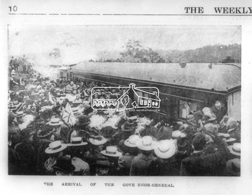
Photograph, Opening of the Railway Line; The arrival of the Governor-General, 6 June, 1902, 1902
Published: The opening of the railway line by His Excellency The Governor General, The Weekly Times, June 14, 1902, p10. Governor General was John Hope, Earl of Hopetoun THE HEIDELBERG TO ELTHAM RAILWAY. OPENING CEREMONY. The opening of the railway line from Heidelberg to Eltham took place on the 6th inst. The special train, containing a large number of members of Parliament, including Mr Trenwith, the Minister for Railways, left Prince's Bridge at half-past eleven, and arrived at Eltham at twenty minutes past twelve. The party was accompanied by Mr Fitzpatrick, Acting Commissioner for Railways; Mr Lockhead, the Traffic Manager; and Mr Norman, Engineer for Existing Lines. On arrival, the visitors were entertained at a banquet in the marquee, of which a photograph is given, erected close to the railway station. Mr E. H. Cameron, M.L.A., the member for the district, occupied the chair, and, seated on his right, was Mr Mason, the Speaker of the Legislative Assembly, and on his left the Minister of Rail-ways. After the banquet His Excellency the Governor-General arrived, and was received and welcomed by Mr Cameron, the local State school children singing the National Anthem. The Governor-General, in declaring the line open, said that he felt highly honored at being asked to perform the opening ceremony, and he trusted that the railway would be a source of great convenience to the inhabitants of the district. He was sorry to say that this would be the last opportunity he would have of seeing them. It cost him a great deal to leave them. (Hear, hear.) He had a great many friends amongst all sections of the community, and he could hardly bear to trust himself to speak about leaving them. (Hear, hear.) He was sorry Lady Hopetoun was on the high seas, and unable to accompany him that day. Mr Cameron thanked his Excellency for performing the opening ceremony, and hoped the trip home would have the effect of restoring His Excellency to good health again. In replying. Lord Hopetoun thanked them sincerely for the cordial vote of thanks. He hoped Providence would shower her blessings over them, and that they would have a series of good seasons. He would always keep a warm corner in his heart for the people of Victoria. (Loud cheers.) THE COUNTRY. In our illustrations, views are given of a couple of sections of the new line, and glimpses of the surrounding country are shown. The line is eight miles in length, and cost £51,000 in construction. Eltham, which is the terminus, possesses many of the features that go to make a favorite holiday resort. It is a quiet picturesque little hamlet, snugly ensconced on the slope of one of many sombre-tinted hills by which it is sur-rounded. Even when viewed under ad-verse conditions one could not fail to be-impressed with the natural, rugged beauty of the place. It is situated about sixteen miles from Melbourne, and the line takes a circuitous course through a continuation of pretty undulating country. At intervals on the slopes of the surrounding green-mantled hills, patches of brown, freshly tilled soil indicate that for all its serene reposeful-ness Eltham possesses its phases of industrial life as well. Looking down into this valley from the main road which skirts the slope of a hill, distant something less than a quarter of a mile from the railway station is one of the prettiest pieces of scenery in the district. Verdure-clad hills ascend on all sides, whilst beneath stretches a broad expanse of carpet-like green sward, dotted here and there with picturesque homesteads, each with its patches of tilled soil. In the township itself the dwelling-houses are comparatively few, the larger portion of the inhabitants residing in the scattered homesteads. Eltham is as yet only in its youth, but energetic and un-tiring public men can effect wonders in a community's prosperity, and Eltham, whatever other real or imaginary advantages it may lay claim to, certainly possesses this one. The railway is the result of their endeavor. 1902 'THE HEIDELBERG TO ELTHAM RAILWAY.', Weekly Times (Melbourne, Vic. : 1869 - 1954), 14 June, p. 14. , viewed 26 Sep 2018, http://nla.gov.au/nla.news-article221230719This photo forms part of a collection of photographs gathered by the Shire of Eltham for their centenary project book,"Pioneers and Painters: 100 years of the Shire of Eltham" by Alan Marshall (1971). The collection of over 500 images is held in partnership between Eltham District Historical Society and Yarra Plenty Regional Library (Eltham Library) and is now formally known as the 'The Shire of Eltham Pioneers Photograph Collection.' It is significant in being the first community sourced collection representing the places and people of the Shire's first one hundred years.Digital image Negative black and white film 120 6x9 format 2 stripsAgfa APX 100sepp, shire of eltham pioneers photograph collection, eltham, heidelberg-eltham railway extension, earl of hopetoun, john hope, opening day, railway line construction -
 Eltham District Historical Society Inc
Negative - Photograph, Diamond Creek, Eltham. Old Diamond Street Bridge
Copy of Rose Series Postcard P. 4314. (The Rose Stereograph Company) Shows two bridge crossings over the Diamond Creek in Diamond Street, Eltham. The upper pedestrian crossing provided continual access for foot traffic during times of flood. The railway came to Eltham in 1901, the Eltham Railway Station is visible in the distance as well as a wooden bodied Tait (Red Rattler) First Class train carriage. The Tait train was first introduced in 1910 as a steam locomotive hauled carriage and in 1919 electric motor carriages were introduced however the line to Heidelberg was not electrified till 1921 and to Eltham in April 1923. The Railway General Store on Main Road is visible beyond the station and was built by Luther Haley in 1902. It was the first shop in the present day shopping centre. It was later known as lloyd's stopre (1917-1920) followed by a succession of six other owners until purchased by Eric Staff in 1939. George Rose founded the Rose Stereograph Company in 1880 and was joined by Herbert (Bert) Cutts in the early 20th Century. The pair formed a lifetime working partnership and strong personal friendship. Assisted by George’s two sons, Herbert George and Walter, and later by Neil Cutts, the Rose Stereograph Company continued its operations for more than 140 years. The company was initially built on stereographs, but as cinema took over and stereographs fell out of fashion, the Rose Stereograph Company developed Australia’s first commercially viable photographic postcard business. Specialising in postcards of iconic historical moments and significant landmarks, The Rose Stereograph Company became a staple of the Australian travel industry.This photo forms part of a collection of photographs gathered by the Shire of Eltham for their centenary project book,"Pioneers and Painters: 100 years of the Shire of Eltham" by Alan Marshall (1971). The collection of over 500 images is held in partnership between Eltham District Historical Society and Yarra Plenty Regional Library (Eltham Library) and is now formally known as 'The Shire of Eltham Pioneers Photograph Collection.' It is significant in being the first community sourced collection representing the places and people of the Shire's first one hundred years.Digital image 4 x 5 inch B&W Negdiamond creek, diamond street bridge, eltham, eltham railway station, glass plate negative, lloyd's general store, postcard, railway station, railway store, rose series postcard, rose stereograph company, shire of eltham pioneers photograph collection, staffs general store, tait train, travel -
 Eltham District Historical Society Inc
Photograph, First electric train at Eltham Railway Station, 15 April 1923
... line electric train On verso in pencil "Const. W.C. Sargeant ...Pages from a scrapbook belonging to Heather Jenkins (nee Sargeant) who lived as a child in the Police Residence at 728 Main Road, Eltham in the 1920s.Heather Sargeant was the daughter of Constable W.C. Sargeant, the local police officer in residence at Eltham, 1922-1927Glued on a brown paper scrapbook page (torn from scrapbook) with 9 black and white/sepia photos of varying sizes, 1 newspaper clipping and handwritten captions in ink.On verso in pencil "Const. W.C. Sargeant 1922-1927 - see Police list"heather jenkins (nee sargeant), eltham, police residence, constable w.c. sargeant, eltham railway station, railway line, electric train -
 Eltham District Historical Society Inc
Photograph, Upper Yarra Dam, Spring Tour, 22 Oct 1995, 22/10/1995
EXPLORING THE UPPER YARRA (Newsletter No. 105, November 1995, by Bettina Woodburn) We enjoyed the Spring Excursion, this year "Exploring the Upper Yarra" - in spite of the constant rain and the countryside under the cloud cover, especially in the valleys, being mainly shiny shades of green. The occasional fields of buttercups, clumps of arum lilies and splendid rhododendron and other flowering bushes became very special. The Cobb and Co coach was warm and a cosy retreat as we zig-zagged on the highways and byways to glimpse the Yarra River, upstream and down, its secret places, and particularly the many bridges. Russell excelled as 'Poet Laureate', reading from Dacre Smyth's book. This 1979 publication includes paintings of all the bridges along the river with poems and brief descriptions of each one. Some of the bridges are in out of the way places and are not very well known. We looked forward to hearing the poetry as much as seeing the ' constructions'…Big Pat (was he short or tall, lean or fat? He did win the two hundred pound reward for discovering gold and had the creek named after him), about the 'Eddies'?, and the disliked 'meccano' bridge in Warburton, etc. etc. The hot roast lunch in the old Reefton Hotel was also most welcome. It was easy to imagine it peopled by miners and early settlers. Starting by crossing the new (1974) concrete bridge at Warrandyte we headed through Wonga Park with views to the Christmas Hills and to the escarpment of the Yering Gorge, which causes flood waters to back up through the Yarra Glen plain, so avoiding disasters downstream. At the end of a long driveway we found the wooden, privately owned Henley Bridge (1935 after the 1934 floods). This facilitates access to different parts of Henley Farm and to Lilydale. Everard Park, named after Blanche Shallard's father, a State Member for 17 years, below the Highway Yarra crossing was in need of care. It is 10 miles from Yarra Glen by road but, as "Yarra Marra” canoeists well know, 32 winding miles down by water. After more delightful countryside scenes we joined the Warburton Highway at Woori Yallock. From the old Railway Station at Launching Place the Centennial Trail for walkers, cyclists and ' horse riders has replaced the rails. The line from Lilydale was opened in 1901, and the last diesel freight train ran to Warburton in 1965. It continued to rain as we had morning tea in Warburton in a shelter between footbridges. From here we continued upstream past the Bridge to O'Shannasy Lodge and Reservoir, Starvation Creek, and the Peninsular tunnel (miners dug it as at Pound Bend) which we visited (scrambling down those steps!) on our return after lunch. Our furthermost point was the Upper Yarra Dam Reserve (and vast catchment area). Finished in 1957 after ten years work and 100 years after Yan Yean, it supplies much of Melbourne's water. After crossing the 30m Launching Place Bridge to the Eltham side of the Yarra and Healesville, we saw in the distance the Yarra Glen Timber Trestle Bridge over the river flats "the longest for years in the land it was said!" Harry's dream of "better weather over the Divide" unfortunately didn't come true, but I'm sure we 36 members will retain happy memories of a day that was wet and green and filled with Bridges. Bettina Woodburn - October 1995 Record of the Society's history of activities - Spring 1995 excursionRoll of 35mm colour negative film, 3 stripsKodak Gold 200-4shire of eltham historical society, activities, upper yarra dam, henley bridge -
 Eltham District Historical Society Inc
Photograph, Upper Yarra Dam, Spring Tour, 22 Oct 1995, 22/10/1995
EXPLORING THE UPPER YARRA (Newsletter No. 105, November 1995, by Bettina Woodburn) We enjoyed the Spring Excursion, this year "Exploring the Upper Yarra" - in spite of the constant rain and the countryside under the cloud cover, especially in the valleys, being mainly shiny shades of green. The occasional fields of buttercups, clumps of arum lilies and splendid rhododendron and other flowering bushes became very special. The Cobb and Co coach was warm and a cosy retreat as we zig-zagged on the highways and byways to glimpse the Yarra River, upstream and down, its secret places, and particularly the many bridges. Russell excelled as 'Poet Laureate', reading from Dacre Smyth's book. This 1979 publication includes paintings of all the bridges along the river with poems and brief descriptions of each one. Some of the bridges are in out of the way places and are not very well known. We looked forward to hearing the poetry as much as seeing the ' constructions'…Big Pat (was he short or tall, lean or fat? He did win the two hundred pound reward for discovering gold and had the creek named after him), about the 'Eddies'?, and the disliked 'meccano' bridge in Warburton, etc. etc. The hot roast lunch in the old Reefton Hotel was also most welcome. It was easy to imagine it peopled by miners and early settlers. Starting by crossing the new (1974) concrete bridge at Warrandyte we headed through Wonga Park with views to the Christmas Hills and to the escarpment of the Yering Gorge, which causes flood waters to back up through the Yarra Glen plain, so avoiding disasters downstream. At the end of a long driveway we found the wooden, privately owned Henley Bridge (1935 after the 1934 floods). This facilitates access to different parts of Henley Farm and to Lilydale. Everard Park, named after Blanche Shallard's father, a State Member for 17 years, below the Highway Yarra crossing was in need of care. It is 10 miles from Yarra Glen by road but, as "Yarra Marra” canoeists well know, 32 winding miles down by water. After more delightful countryside scenes we joined the Warburton Highway at Woori Yallock. From the old Railway Station at Launching Place the Centennial Trail for walkers, cyclists and ' horse riders has replaced the rails. The line from Lilydale was opened in 1901, and the last diesel freight train ran to Warburton in 1965. It continued to rain as we had morning tea in Warburton in a shelter between footbridges. From here we continued upstream past the Bridge to O'Shannasy Lodge and Reservoir, Starvation Creek, and the Peninsular tunnel (miners dug it as at Pound Bend) which we visited (scrambling down those steps!) on our return after lunch. Our furthermost point was the Upper Yarra Dam Reserve (and vast catchment area). Finished in 1957 after ten years work and 100 years after Yan Yean, it supplies much of Melbourne's water. After crossing the 30m Launching Place Bridge to the Eltham side of the Yarra and Healesville, we saw in the distance the Yarra Glen Timber Trestle Bridge over the river flats "the longest for years in the land it was said!" Harry's dream of "better weather over the Divide" unfortunately didn't come true, but I'm sure we 36 members will retain happy memories of a day that was wet and green and filled with Bridges. Bettina Woodburn - October 1995 Record of the Society's history of activities - Spring 1995 excursionRoll of 35mm colour negative film, 2 stripsKodak Gold 100-4shire of eltham historical society, activities, upper yarra dam, henley bridge -
 Eltham District Historical Society Inc
Photograph, Upper Yarra Dam, Spring Tour, 22 Oct 1995, 22/10/1995
EXPLORING THE UPPER YARRA (Newsletter No. 105, November 1995, by Bettina Woodburn) We enjoyed the Spring Excursion, this year "Exploring the Upper Yarra" - in spite of the constant rain and the countryside under the cloud cover, especially in the valleys, being mainly shiny shades of green. The occasional fields of buttercups, clumps of arum lilies and splendid rhododendron and other flowering bushes became very special. The Cobb and Co coach was warm and a cosy retreat as we zig-zagged on the highways and byways to glimpse the Yarra River, upstream and down, its secret places, and particularly the many bridges. Russell excelled as 'Poet Laureate', reading from Dacre Smyth's book. This 1979 publication includes paintings of all the bridges along the river with poems and brief descriptions of each one. Some of the bridges are in out of the way places and are not very well known. We looked forward to hearing the poetry as much as seeing the ' constructions'…Big Pat (was he short or tall, lean or fat? He did win the two hundred pound reward for discovering gold and had the creek named after him), about the 'Eddies'?, and the disliked 'meccano' bridge in Warburton, etc. etc. The hot roast lunch in the old Reefton Hotel was also most welcome. It was easy to imagine it peopled by miners and early settlers. Starting by crossing the new (1974) concrete bridge at Warrandyte we headed through Wonga Park with views to the Christmas Hills and to the escarpment of the Yering Gorge, which causes flood waters to back up through the Yarra Glen plain, so avoiding disasters downstream. At the end of a long driveway we found the wooden, privately owned Henley Bridge (1935 after the 1934 floods). This facilitates access to different parts of Henley Farm and to Lilydale. Everard Park, named after Blanche Shallard's father, a State Member for 17 years, below the Highway Yarra crossing was in need of care. It is 10 miles from Yarra Glen by road but, as "Yarra Marra” canoeists well know, 32 winding miles down by water. After more delightful countryside scenes we joined the Warburton Highway at Woori Yallock. From the old Railway Station at Launching Place the Centennial Trail for walkers, cyclists and ' horse riders has replaced the rails. The line from Lilydale was opened in 1901, and the last diesel freight train ran to Warburton in 1965. It continued to rain as we had morning tea in Warburton in a shelter between footbridges. From here we continued upstream past the Bridge to O'Shannasy Lodge and Reservoir, Starvation Creek, and the Peninsular tunnel (miners dug it as at Pound Bend) which we visited (scrambling down those steps!) on our return after lunch. Our furthermost point was the Upper Yarra Dam Reserve (and vast catchment area). Finished in 1957 after ten years work and 100 years after Yan Yean, it supplies much of Melbourne's water. After crossing the 30m Launching Place Bridge to the Eltham side of the Yarra and Healesville, we saw in the distance the Yarra Glen Timber Trestle Bridge over the river flats "the longest for years in the land it was said!" Harry's dream of "better weather over the Divide" unfortunately didn't come true, but I'm sure we 36 members will retain happy memories of a day that was wet and green and filled with Bridges. Bettina Woodburn - October 1995 Record of the Society's history of activities - Spring 1995 excursionRoll of 35mm colour negative film, 4 of 5 stripsKodak Gold 400-5shire of eltham historical society, activities, upper yarra dam, henley bridge -
 Eltham District Historical Society Inc
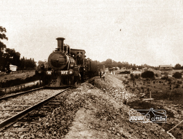
Negative - Photograph, Railway construction train hauled by steam locomotive W-197 between Eltham and Hurstbridge, c.1912
The locomotive was built by the American Baldwin Locomotive works in 1880 and was converted to a W class engine by the Phoenix Foundry at Ballarat in 1882. Agitation for a railway extension began in 1888 when a meeting was held at Arthurs Creek to press for the construction of a railway line from Heidelberg to Kinglake. The Chairman Mr Charles Draper said this was necessary because this was the best fruit growing district in Victoria. Mr Cameron M.P. pointed out that whatever route the line took it would have to follow the Diamond Valley from Eltham. At the same time another meeting was pressing for the line to be extended to Queenstown (St Andrews). However when detailed surveys were made it was discovered that the only possible route was to Hurstbridge because of the hills. In 1912 the railway was opened terminating at Hurstbridge. Roll of 35mm colour negative film, 4 stripsKodak Safety 5035steam train, w-197, railway construction, steam locomotive -
 Eltham District Historical Society Inc
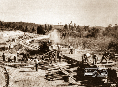
Photograph, Railway construction, Wattle Gen, c.1911-12
Agitation for a railway extension began in 1888 when a meeting was held at Arthurs Creek to press for the construction of a railway line from Heidelberg to Kinglake. The Chairman Mr Charles Draper said this was necessary because this was the best fruit growing district in Victoria. Mr Cameron M.P. pointed out that whatever route the line took it would have to follow the Diamond Valley from Eltham. At the same time another meeting was pressing for the line to be extended to Queenstown (St Andrews). However when detailed surveys were made it was discovered that the only possible route was to Hurstbridge because of the hills. In 1912 the railway was opened terminating at Hurstbridge. Roll of 35mm colour negative film, 4 stripsKodak Safety 5035steam train, railway construction, wattle glen -
 Kiewa Valley Historical Society
Ball Gown - Pink
Bright pink ball gown , with lace sleeves and floating panel. Long straight pink satin dress with lace sleeves and scoop neck. Princess line with lace under the bodice and across the back. Long back zip and a pleated chiffon attached train.Black label across the top 2 inches x 1 inch.ball gown, reid family -
 Eltham District Historical Society Inc
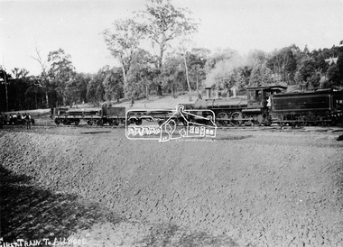
Photograph, First train to Hurstbridge
The first steam train to Hurstbridge was probably this one which carried equipment for the construction of the rail line and railway station. The formal opening of the train extension from Eltham to Hurstbridge railway station took place on June 25, 1912. The area was known as Allwood and was offically proclaimed as Hurstbridge in 1924. This photo forms part of a collection of photographs gathered by the Shire of Eltham for their centenary project book, "Pioneers and Painters: 100 years of the Shire of Eltham" by Alan Marshall (1971). The collection of over 500 images is held in partnership between Eltham District Historical Society and Yarra Plenty Regional Library (Eltham Library) and is now formally known as 'The Shire of Eltham Pioneers Photograph Collection.' It is significant in being the first community sourced collection representing the places and people of the Shire's first one hundred years.Digital imagesepp, shire of eltham pioneers photograph collection, diamond creek, hurstbridge, wattle glen, allwood, steam train, construction, railroad -
 Eltham District Historical Society Inc
Photograph, Steam Train, 18 April 1971
Passengers hang out the windows of the vintage steam train as it travels along the Hurstbridge Railway Line. Regular trips travelled from Montmorency to Hurstbridge and return as part of the Shire of Eltham centenary program. The train also stopped at Eltham, Diamond Creek and Wattle Glen stations on the afternoon of Sunday 18th April 1971. This photo forms part of a collection of photographs gathered by the Shire of Eltham for their centenary project book, "Pioneers and Painters: 100 years of the Shire of Eltham" by Alan Marshall (1971). The collection of over 500 images is held in partnership between Eltham District Historical Society and Yarra Plenty Regional Library (Eltham Library) and is now formally known as 'The Shire of Eltham Pioneers Photograph Collection.' It is significant in being the first community sourced collection representing the places and people of the Shire's first one hundred years.Digital imagesepp, shire of eltham pioneers photograph collection, shire of eltham, shire of eltham centenary, centenary celebrations, steam train -
 Eltham District Historical Society Inc
Photograph, Russell Yeoman, Onlookers watch from below as a steam train passes over the trestle bridge at Eltham, c.1970, 1970c
... melbourne russell yeoman collection Eltham Railway Line Trestle ...Digital file only; created from original colour positive slide transparencyrussell yeoman collection, eltham, railway line, trestle bridge, steam train -
 Eltham District Historical Society Inc
Photograph, Henley Bridge, Spring Excursion, Exploring the Upper Yarra, 22 October 1995, 22/10/1995
[article by Bettina Woodburn in EDHS Newsletter No. 105, November 1995:] EXPLORING THE UPPER YARRA - We enjoyed the Spring Excursion, this year "Exploring the Upper Yarra" - in spite of the constant rain and the countryside under the cloud cover, especially in the valleys, being mainly shiny shades of green. The occasional fields of buttercups, clumps of arum lilies and splendid rhododendron and other flowering bushes became very special. The Cobb and Co coach was warm and a cosy retreat as we zig-zagged on the highways and byways to glimpse the Yarra River, upstream and down, its secret places, and particularly the many bridges. Russell excelled as 'Poet Laureate', reading from Dacre Smyth's book. This 1979 publication includes paintings of all the bridges along the river with poems and brief descriptions of each one. Some of the bridges are in out-of-the-way places and are not very well known. We looked forward to hearing the poetry as much as seeing the 'constructions'… Big Pat (was he short or tall, lean or fat? - he did win the £200 reward for discovering gold and had the creek named after him), about the 'Eddies'?, and the disliked 'meccano' bridge in Warburton, etc. etc. The hot roast lunch in the old Reefton Hotel was also most welcome. It was easy to imagine it peopled by miners and early settlers. Starting by crossing the new (1974) concrete bridge at Warrandyte we headed through Wonga Park with views to the Christmas Hills and to the escarpment of the Yering Gorge, which causes flood waters to back up through the Yarra Glen plain, so avoiding disasters downstream. At the end of a long driveway we found the wooden, privately owned Henley Bridge (1935 after the 1934 floods). This facilitates access to different parts of Henley Farm and to Lilydale. Everard Park, named after Blanche Shallard's father, a State Member for 17 years, below the Highway Yarra crossing was in need of care. It is 10 miles from Yarra Glen by road but, as "Yarra Marra” canoeists well know, 32 winding miles down by water. After more delightful countryside scenes we joined the Warburton Highway at Woori Yallock. From the old Railway Station at Launching Place the Centennial Trail for walkers, cyclists and horse riders has replaced the rails. The line from Lilydale was opened in 1901, and the last diesel freight train ran to Warburton in 1965. It continued to rain as we had morning tea in Warburton in a shelter between footbridges. From here we continued upstream past the Bridge to O'Shannassy Lodge and Reservoir, Starvation Creek, and the Peninsular tunnel (miners dug it as at Pound Bend) which we visited (scrambling down those steps!) on our return after lunch. Our furthermost point was the Upper Yarra Dam Reserve (and vast catchment area). Finished in 1957 after ten years' work and 100 years after Yan Yean, it supplies much of Melbourne's water. After crossing the 30m Launching Place Bridge to the Eltham side of the Yarra and Healesville, we saw in the distance the Yarra Glen Timber Trestle Bridge over the river flats "the longest for years in the land it was said!" Harry's dream of "better weather over the Divide" unfortunately didn't come true, but I'm sure we 36 members will retain happy memories of a day that was wet and green and filled with Bridges. Situated on the Yarra River, 5.5 kms south of Christmas Hills on private property. This timber trestle bridge is said to have been built some time after 1907 by Melbourne master-builder, David Mitchell (the father of Dame Nellie Melba), to connect his two "Henley Farm" properties with Lilydale. In earlier days, when the McPhersons owned the property, their children used a punt to cross the river to attend Yering Primary School. This private bridge is best viewed from the end of Wendy Way. - Source: Christmas Hills Past and Present, Yarra Glen & District Historical Society, 2004.Two colour photographsactivities, henley bridge, upper yarra -
 Eltham District Historical Society Inc
Photograph, Spring Excursion, Exploring the Upper Yarra, 22 October 1995, 22/10/1995
[article by Bettina Woodburn in EDHS Newsletter No. 105, November 1995:] EXPLORING THE UPPER YARRA - We enjoyed the Spring Excursion, this year "Exploring the Upper Yarra" - in spite of the constant rain and the countryside under the cloud cover, especially in the valleys, being mainly shiny shades of green. The occasional fields of buttercups, clumps of arum lilies and splendid rhododendron and other flowering bushes became very special. The Cobb and Co coach was warm and a cosy retreat as we zig-zagged on the highways and byways to glimpse the Yarra River, upstream and down, its secret places, and particularly the many bridges. Russell excelled as 'Poet Laureate', reading from Dacre Smyth's book. This 1979 publication includes paintings of all the bridges along the river with poems and brief descriptions of each one. Some of the bridges are in out-of-the-way places and are not very well known. We looked forward to hearing the poetry as much as seeing the 'constructions'… Big Pat (was he short or tall, lean or fat? - he did win the £200 reward for discovering gold and had the creek named after him), about the 'Eddies'?, and the disliked 'meccano' bridge in Warburton, etc. etc. The hot roast lunch in the old Reefton Hotel was also most welcome. It was easy to imagine it peopled by miners and early settlers. Starting by crossing the new (1974) concrete bridge at Warrandyte we headed through Wonga Park with views to the Christmas Hills and to the escarpment of the Yering Gorge, which causes flood waters to back up through the Yarra Glen plain, so avoiding disasters downstream. At the end of a long driveway we found the wooden, privately owned Henley Bridge (1935 after the 1934 floods). This facilitates access to different parts of Henley Farm and to Lilydale. Everard Park, named after Blanche Shallard's father, a State Member for 17 years, below the Highway Yarra crossing was in need of care. It is 10 miles from Yarra Glen by road but, as "Yarra Marra” canoeists well know, 32 winding miles down by water. After more delightful countryside scenes we joined the Warburton Highway at Woori Yallock. From the old Railway Station at Launching Place the Centennial Trail for walkers, cyclists and horse riders has replaced the rails. The line from Lilydale was opened in 1901, and the last diesel freight train ran to Warburton in 1965. It continued to rain as we had morning tea in Warburton in a shelter between footbridges. From here we continued upstream past the Bridge to O'Shannassy Lodge and Reservoir, Starvation Creek, and the Peninsular tunnel (miners dug it as at Pound Bend) which we visited (scrambling down those steps!) on our return after lunch. Our furthermost point was the Upper Yarra Dam Reserve (and vast catchment area). Finished in 1957 after ten years' work and 100 years after Yan Yean, it supplies much of Melbourne's water. After crossing the 30m Launching Place Bridge to the Eltham side of the Yarra and Healesville, we saw in the distance the Yarra Glen Timber Trestle Bridge over the river flats "the longest for years in the land it was said!" Harry's dream of "better weather over the Divide" unfortunately didn't come true, but I'm sure we 36 members will retain happy memories of a day that was wet and green and filled with Bridges.Two colour photographsactivities, upper yarra, upper yarra dam -
 Eltham District Historical Society Inc
Photograph, Yarra River from Henley Bridge, Kangaroo Ground, Spring Excursion, Exploring the Upper Yarra, 22 October 1995, 22/10/1995
[article by Bettina Woodburn in EDHS Newsletter No. 105, November 1995:] EXPLORING THE UPPER YARRA - We enjoyed the Spring Excursion, this year "Exploring the Upper Yarra" - in spite of the constant rain and the countryside under the cloud cover, especially in the valleys, being mainly shiny shades of green. The occasional fields of buttercups, clumps of arum lilies and splendid rhododendron and other flowering bushes became very special. The Cobb and Co coach was warm and a cosy retreat as we zig-zagged on the highways and byways to glimpse the Yarra River, upstream and down, its secret places, and particularly the many bridges. Russell excelled as 'Poet Laureate', reading from Dacre Smyth's book. This 1979 publication includes paintings of all the bridges along the river with poems and brief descriptions of each one. Some of the bridges are in out-of-the-way places and are not very well known. We looked forward to hearing the poetry as much as seeing the 'constructions'… Big Pat (was he short or tall, lean or fat? - he did win the £200 reward for discovering gold and had the creek named after him), about the 'Eddies'?, and the disliked 'meccano' bridge in Warburton, etc. etc. The hot roast lunch in the old Reefton Hotel was also most welcome. It was easy to imagine it peopled by miners and early settlers. Starting by crossing the new (1974) concrete bridge at Warrandyte we headed through Wonga Park with views to the Christmas Hills and to the escarpment of the Yering Gorge, which causes flood waters to back up through the Yarra Glen plain, so avoiding disasters downstream. At the end of a long driveway we found the wooden, privately owned Henley Bridge (1935 after the 1934 floods). This facilitates access to different parts of Henley Farm and to Lilydale. Everard Park, named after Blanche Shallard's father, a State Member for 17 years, below the Highway Yarra crossing was in need of care. It is 10 miles from Yarra Glen by road but, as "Yarra Marra” canoeists well know, 32 winding miles down by water. After more delightful countryside scenes we joined the Warburton Highway at Woori Yallock. From the old Railway Station at Launching Place the Centennial Trail for walkers, cyclists and horse riders has replaced the rails. The line from Lilydale was opened in 1901, and the last diesel freight train ran to Warburton in 1965. It continued to rain as we had morning tea in Warburton in a shelter between footbridges. From here we continued upstream past the Bridge to O'Shannassy Lodge and Reservoir, Starvation Creek, and the Peninsular tunnel (miners dug it as at Pound Bend) which we visited (scrambling down those steps!) on our return after lunch. Our furthermost point was the Upper Yarra Dam Reserve (and vast catchment area). Finished in 1957 after ten years' work and 100 years after Yan Yean, it supplies much of Melbourne's water. After crossing the 30m Launching Place Bridge to the Eltham side of the Yarra and Healesville, we saw in the distance the Yarra Glen Timber Trestle Bridge over the river flats "the longest for years in the land it was said!" Harry's dream of "better weather over the Divide" unfortunately didn't come true, but I'm sure we 36 members will retain happy memories of a day that was wet and green and filled with Bridges.Colour photographactivities, upper yarra, henley bridge -
 Orbost & District Historical Society
ticket voucher book, Victorian Railways Commission, c. 1939 - 1987
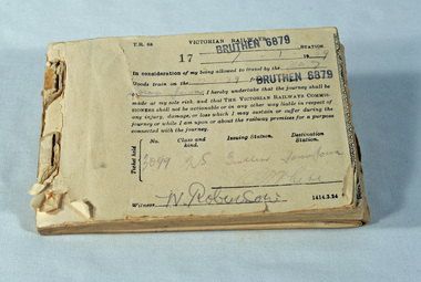
A ticket voucher book used on the railway line between Bairnsdale and Orbost which closed in 1987. Escept for special events, passenger trains ceased in 1937 and after that time, passengers wishing to travel by train had to take the good trains and be issued with this ticket. The train guard may have issued these tickets.This item is associated with the history of the Orbost-Bairnsdale railway line and therefore reflects the role that the rail line played in the social and economic history of Orbost.A Victorian Railways ticket voucher book. This is a tear-off ticket book, stapled at the left margin. It was used for passengers travelling on goods trains from Bruthen Railway Station.TR88 Victorian Railways BRUTHEN 6879 STATION 7/1/1939. In consideration of my being able to travel by the ......goods train on the 7/1/39 from BRUTHEN 6879 to NOWA NOWA, I hereby unertake ........................... etc.railway-history orbost-bairnsdale-railway-line -
 Orbost & District Historical Society
black and white photograph, second half 20th century
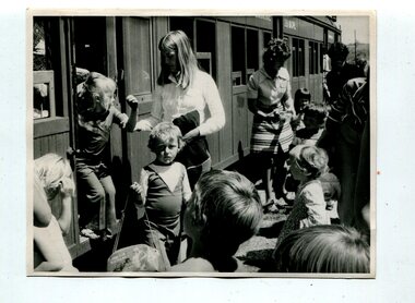
This photograph is of a group of pre-schoolers returning from a train trip to Nowa Nowa. It has been taken at Orbost Railway Station. A steam train? Although the Orbost Bairnsdale Rail Line was closed as a passenger line from 1935 to be used as a freight line, there were often special passenger trains.A black / white photograph of a group of women and young children alighting from a train.railway-orbost excursion-children -
 Orbost & District Historical Society
black and white photograph, second half 20th century
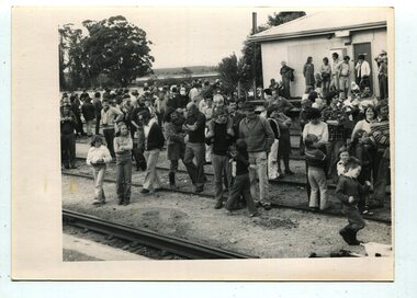
This appears to be a photograph of a large group of people at the Orbost Railway Station awaiting a train - a steam train? The group seems to be made up of family groups. This item is associated with the history of the Orbost-Bairnsdale railway line and therefore reflects the role that the rail line played in the social and economic history of Orbost. The closure of the line was a significant event in Orbost's history. It is a pictorial record of a social event in Orbost.A black / white photograph of a large group of people standing at a railway station. Some are standing on the platform, others on the line. Most are looking toward the right.orbost-railway-station family-activity -
 Orbost & District Historical Society
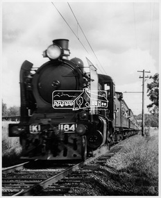
black and white photograph, Barkla, Ian R, 1925
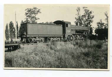
This is a photograph of Steam Engine K104. K104 was numbered as such in 1923. Engines were renumbered from K100-K109 to K140-149 in 1940. This one was renumbered as K144. The Bairnsdale-Orbost railway was opened in 1916 to serve the agricultural and timber industry. Because of the decline in traffic and heavy operating costs, the line was finally closed in August, 1987.This is a pictorial record of rail transport in the 1920s. This item is associated with the history of the Orbost-Bairnsdale railway line and therefore reflects the role that the rail line played in the social and economic history of Orbost. On April 10 1916, the first scheduled train service left Orbost for Bairnsdale. The Bairnsdale-Orbost railway was opened to serve the agricultural and timber industry. Because of the decline in traffic and heavy operating costs, the line was finally closed in August, 1987.A black / white photograph of a steam locomotive. on back - "Orbost 1924 Steam Engine K104"orbost-railway steam-locomotive-k104 transport-rail -
 Orbost & District Historical Society
black and white photographs, April 1916
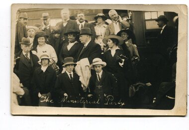
These photographs were taken at the official opening of the Orbost - Bairnsdale Railway Line. In 3150.3 which is of a group of children and two adults those identified in the photograph are ; L - R front row Mary Gilbert; Warren; Betty Gilbert; Marion Gilbert; Mrs Shaw and son; ? Gay; and Pen Gilbert. In 3150.4 L-R front " Mary Gilbert; Bet Gilbert (sitting with glasses); Pen Gilbert(Richardson); Marion Gilbert ( middle front little girl) About 1912 work began at Newmerella on clearing the track for the railway line from Bairnsdale to Orbost. A canvas town sprang up on the higher land adjacent to the river flats. Local farmers supplied meat, milk and fresh produce to the camp, as well as gaining employment carting and labouring. The line opened in 1916, the Orbost railway station being built on the Newmerella side of the river.This item is associated with the history of the Orbost-Bairnsdale railway line and therefore reflects the role that the rail line played in the social and economic history of Orbost. It is a pictorial record of a significant event in Orbost's history. On April 10 1916, the first scheduled train service left Orbost for Bairnsdale. The Bairnsdale-Orbost railway was opened to serve the agricultural and timber ndustry. Because of the decline in traffic and heavy operating costs, the line was finally closed in August, 1987. Four black / white postcards of people at the opening of The Orbost - Bairnsdale Railway. 3150.1 - on front - "The Ministerial Party" 3150.2 - on front - hand-written - " The Hon James Cameron" with arrow pointing to a man standing in the back row. at bottom - "The Ministerial Party X Florie Cameron" on back- "Opening the Orbost Railway" 3150.3 and 3150.4 - on back - hand-written "First train to Orbost with a list of names.orbost-bairnsdale-railway celebration-opening-of-railway east-gippsland-railway -
 Orbost & District Historical Society
black and white photographs, second half 20th century
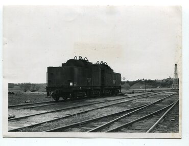
3151.1 is of a water tanker on stand by at Orbost ready for emergency use. Similar suppliers were at Bairnsdale and Nowa Nowa. The two tankers hels about 9,000 gallons (34068.7 litres) - from a news item in "Gippsland" September, 1971. 3151.2 is of Victoria's X class 1,800 H.P general purpose diesel electric locomotive. Si had been ordered for the Victorian Railways and cost about £ 250,000 each. 3151.3 is of several loaded, covered railway trucks on a rail line. 3151.4 was taken at the goods yard at Orbost Railway Station. 3151.5 has some rail wagons with "SHOWMOBILE COUNCIL OF ADULT EDUCATION" on the sides. 3151.6 is of goods wagons (Probably not at Orbost Station) 3151.7 is a goods train 3151.8 shows the loading or unloading of farm produce at Orbost railway Station. 3151.9 shows cattle being loaded at Orbost Railway Station. 3151.10 is of a container N.Y.K. LINE ( a Japanese shipping company) This item is associated with the history of the Orbost-Bairnsdale railway line and therefore reflects the role that the rail line played in the social and economic history of Orbost.Ten black / white photographs related to Orbost rail. orbost-railway east-gippsland-railway transport-railway railway-engine orbost-railway-station export-produce -
 Orbost & District Historical Society
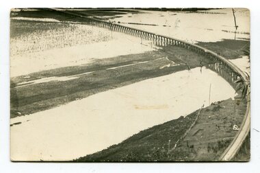
black and white photographs, second half 20th century
3154.1 is a postcard of the Orbost viaduct over the flooded Snowy River flats. 4153.2 is of a goods train on the viaduct. 3154.3 is of a loaded goods train with the driver at the window. Two men are standing on the plate and there are two workers below where there is some water and flood debris. 3154.4 is of amachine moving flood debris on the rail line. 3154.5 shows flood damage to the viaduct across the Snowy River flats. Two men are driving a dozer.This item is associated with the history of the Orbost-Bairnsdale railway line and therefore reflects the role that the rail line played in the social and economic history of Orbost.Five black / white photographs associated with the Orbost railway line during a flood.orbost-railway east-gippsland -railway orbost-floods -
 Orbost & District Historical Society
black and white photographs, 20th century
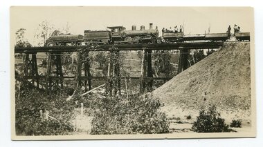
These photographs are probably of bridges on the East Gippsland railway line. 3162.2 is possibly Hospital Creek and 3162.3 possibly Burn Road Newmerella. The Orbost-Bairnsdale railway initially played a crucial role in developing agricultural industries in Gippsland as well as tourism. It opened in 1916 and operated until 1987, principally carrying timber and farming produce. In the early days of the railway's operation dedicated passenger trains ran but these ceased by the 1930s. The line was completely closed to freightage in 1987.The track infrastructure was dismantled in 1994 and has been redeveloped as the East Gippsland Rail Trail.These photographs are associated with the history of the Orbost-Bairnsdale railway line and therefore reflects the role that the rail line played in the social and economic history of Orbost. Three black / white photographs of railway bridges. 3162.1 has a steam train on the bridge. 3162.3 shows three men on the right working at clearing vegetation. 3162.3 has been taken from a height.orbost-bairnsdale-railway east-gippsland-railway bridges-railway -
 Orbost & District Historical Society
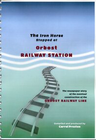
Book, The Iron Horse Stopped at Orbost Railway Station, 2019
Carrol Preston has used newspaper references from 1877 through to 1917, to document the history of the Orbost - Bairnsdael railway line.. It starts with the lobbying and jockeying, and moves through to the opening in 1916. The title is a reference to plans to further extend the railway beyond Orbost - but "The Iron Horse stopped at Orbost Railway Station". Most articles are from the Snowy River Mail and Bairnsdale Advertiser. All newspaper articles are dated and sourced. About 1912 work began at Newmerella on clearing the track for the railway line from Bairnsdale to Orbost. A canvas town sprang up on the higher land adjacent to the river flats. Local farmers supplied meat, milk and fresh produce to the camp, as well as gaining employment carting and labouring. The line opened in 1916, the Orbost railway station being built on the Newmerella side of the river.This item is associated with the history of the Orbost-Bairnsdale railway line and therefore reflects the role that the rail line played in the social and economic history of Orbost. On April 10 1916, the first scheduled train service left Orbost for Bairnsdale. The Bairnsdale-Orbost railway was opened to serve the agricultural and timber industries. This book has been compiled by a local historian. A spiral bound book titled, "The Iron Horse Stopped at Orbost Railway Station". The cover is blue / green with the title in black and red print. Underneath is a railway track leading to the bottom of the page. The book is 110 pages, A4 size and contains maps and photos. in black print on cover - "The Iron Horse Stopped at Orbost Railway Station ; The newspaper story of the eventual construction of the ORBOST RAILWAY LINE (in red print); Compiled and produced by CARROL PRESTON (in white print)railway-transport orbost-bairnsdale-railway east-gippsland-railway