Showing 557 items matching " tram junction"
-
 Ballarat Tramway Museum
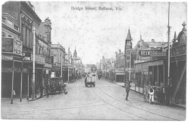
Postcard - Bridge Sreet Ballarat Vic, VSM Melbourne
Postcard - Bridge Sreet, Ballarat Vic showing tram tracks, a number of horse drawn carts and cabs. On the far right, a tram stop sign can be seen, along with men talking. In the view are shops, businesses or advertisements for: Junction Boot Store, Havelock Tobacco, Halls Corner, A Bregeut Ales & Butter shop, W A Stark Wines and Spirits, Velvet Soap, Thomas Dunstan? Leather Merchant.Yields infomation about the corner of Bridge Street, Main Road and Victoria Streets.Black and white postcard titled Bridge Sreet Ballarat Vic, looking west from the corner of Bridge Street, Main Road and Victoria Streets 1910c. Divided back type, published by VSM Melboune and printed in Prussia.bridge street, ballarat, stones corner, victoria street, main road, tramways, tram track, horse drawn vehicles -
 Ballarat Tramway Museum
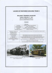
Document, Launch of restored Geelong tram 2 - 6-2-2022
Prepared for the launch of Geelong Tram No. 2 giving details of the program and the tram itself. Has a list of speakers and timing. Launched on 6/2/2022 at Depot Junction.Yields information about the program to launch Geelong No. 2 and the tram itself.Printed A3 sheet, double sided, giving details of the Launch programme 6/2/2022trams, tramways, geelong, tram 2, btm, programmes, program -
 Ballarat Tramway Museum
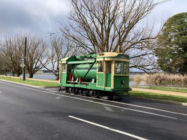
Photograph - Commissioning the new track in Wendouree Parade, Paul Mong, 25-8-2022
Following reconstruction of the track between Depot Junction and St Aidans drive, the track was tested and commissioned: 1 - Scrubber tram 8 at St Aidans Drive 2 - Trams 33 and 671 in the new loop at Gardens Loop Wendouree Parade. 3 - Trams 28 and 38 at Carlton StDemonstrates the commissioning of the replaced track in Wendouree Parade.Set of three digital images of the Commissioning of the new track in Wendouree Parade 25-8-2022btm, new track, track replacement, track work, wendouree parade, commssioning, tram 8, tram 33, tram 671, tram 28, tram 38 -
 Ballarat Tramway Museum
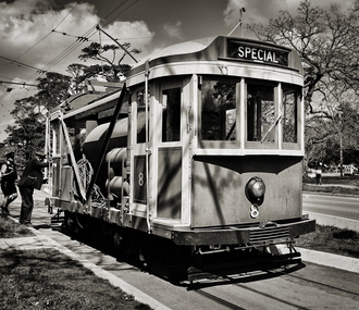
Photograph - BTM Scrubber tram No. 8, Greg Naylor, 2022
... Museum's scrubber tram No. 8 at Depot Junction. See reference ...Photo of Ballarat Tramway Museum's scrubber tram No. 8 at Depot Junction. See reference for the history of this tram. Photographed during 2022 on a Mamiya RB67 large format film camera.Yields information about BTM tram 8, used as the rail scrubber.Black and White photo of BTM Scrubber tram No. 8 at Depot Junction.btm, trams, tramcars, scrubber tram, tram 8 -
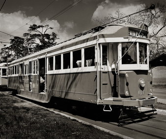 Ballarat Tramway Museum
Photograph - MTPA W2 class tram No. 407, Greg Naylor, 2022
Melbourne Tramcar Preservation Association W2 407, on loan to the Ballarat Tramway Museum. See reference for the history of this tram. Photographed during 2022 on a Mamiya RB67 large format film camera.Yields information about MTPA tram 407 on loan to the BTM.Black and White photo of Photo of MTPA W2 class tram No. 407 at depot Junction.btm, trams, tramcars, w2 class, tram 407, mtpa -
 Ballarat Tramway Museum
Sign - Tram Stop Information, State Electricity Commission of Victoria (SECV), Stop Information
... junction. Stop Information Sign Tram Stop Information State ...Sheet metal signs mounted onto 2 metal brackets top and bottom by rivets. Mounted on wood pole so it faced outwards at right angles. On both faces in black paint on white background is "Trams Leave here for Gardens, View Point, Sebastopol." Believed to be located at the intersection of Sturt St and Drummond St. on the south side before junction.trams, tramways, ballarat, secv, street furniture, tram stops, route signs -
Ballarat Tramway Museum
Sign, State Electricity Commission of Victoria (SECV), "CARS TAKE FOLLOWING LINE"
Galvanised sheet steel with top & bottom holes(central) & side mounting brackets & rounded corners. Painted with black base and white letters and lines used to indicate which depot track(Line) trams were to be parked or stabled on when returning to the depot. Depot had four under cover tracks (1 to 4) and one outside track ("0") road. Lettered as shown on the sketch on the original worksheet. Reg. Item No. 1170.1? shows the object in a wooden frame mounted onto a pole opposite the depot, by depot junction point.trams, tramways, depot, secv, ballarat, tramcar operations, operations -
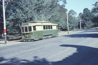
 Ballarat Tramway Museum
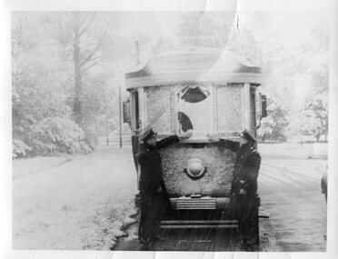
Photograph - Black & White Photograph/s, late 1940s
Yields information about the impact of a snow storm in Wendouree Parade.Photo of an Ex HTT bogie tram (see also item 289) in Wendouree parade, just north of present BTM depot junction, with crew standing in front of tram brushing snow off front after a snowstorm. Approx date between 1946 and 1952, possibly 1948. See Reg. Item 2793 for another print of this photograph.On rear in pencil "26/88" plus other markingstrams, tramways, ballarat bogie tram, wendouree parade, snowstorm -
 Ballarat Tramway Museum
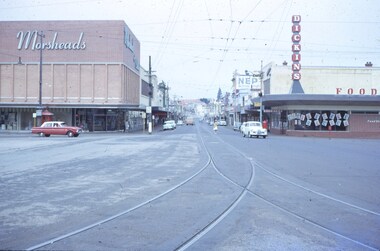
Slide - 35mm slide/s, Feb. 1963
View looking down Bridge St. from east end of Sturt St. Photographer standing before junction of tracks, looking east. No trams in photo, two or three cars on the roads. With Morseheads and Dickins stores on the corner.'Ballarat Feb. 1963, Bridge St in blue inktramways, trams, bridge st., grenville st -
 Ballarat Tramway Museum
Photograph - Black and White photocopy, Travis Jeffrey, 1961
... junction, in 1961. Tram fitted with lights and small white stripe... depot junction, in 1961. Tram fitted with lights and small white ...Negative No. N387 and black and white print made by a laser printer (stored in folder) of Ballarat No. 39 passing depot junction, in 1961. Tram fitted with lights and small white stripe. Small triangles in corners of front dash. Ad for 60/40 dancing at Civil hall on front of tram. Showing Victoria Street destination. Lake in background, no other vehicles. Photo by Travis Jeffrey, who advised could be Dave Kellett driving. Date of photo on folder 5/9/1960. Date of photo could be incorrect, due to fitting of lights taking place late 1960. Large print of this photo made for display 1995c. Item updated when negative added to collection - 1/6/2003. Original negative rescanned 24/5/2020 and image file updated. Paper print of original photo in folder 73.Paper folder that contained the negative had "NR40A" in red ink, "BA14" in pencil, date stamp of "5 Sep 1960" on front, and on rear date stamps "26 Sep 1962" and "6 Oct 1962".trams, tramways, ballarat, wendouree parade, tram 39 -
 Ballarat Tramway Museum
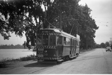
Slide - 35mm slide/s, Wal Jack, 24/03/1959 12:00:00 AM
Ballarat tram No. 30 in Wendouree Parade, Gardens, just before Ballarat Tramway Museum's junction. Has Mount Pleasant destination, large triangles on front dashes. Has just past a tram stop, No other vehicles on the roadway, including no parked motor cars.'SEC No. 30 at Gardens, Ballarat, 24-3-1959, W.Jack Photo' in blue ink.tramways, trams, ballarat, gardens, wendouree parade, tram 30 -
 Kew Historical Society Inc
Photograph - 'Mount Eri', 9 Highbury Grove, 1919
Subdivision plans are historically important documents used as evidence of the growth of suburbs in Australia. They frequently provide information about when the land was sold on which a built structure was subsequently constructed as well as evidence relating to surveyors and real estate and financial agents. The numerous subdivision plans in the Kew Historical Society's collection represent working documents, ranging from the initial sketches made in planning a subdivision to printed plans on which auctioneers or agents listed the prices for which individual lots were sold. In a number of cases, the reverse of a subdivision plan in the collection includes a photograph of a house that was also for sale by the agent. These photographs provide significant heritage information relating house design and decoration, fencing and household gardens.A photograph of Mount Eri, 9 Highbury Grove, an 11-room house for sale near the junction of Cotham and Glenferrie Roads. The substantial red brick, slate-roofed house and its location are not identified in the photograph, although the extent of the house is noted. It was described then as ‘well situated’ and close to 3 trams. Mathers, a financial agent in Cotham Road, placed advertisements about the sale of the property in The Argus in May and June 1919. The advertisement additionally refers to a billiard room and asserts that the house has every modern convenience. An annotation on the plan indicates that the house, with tennis court, was sold for £1960. Following extensive research, the house has now been conclusively identified, albeit extended and rendered. The house was originally built in the 19th century as a school and for much of the 20th century was used as a venue for receptions. -
 Kew Historical Society Inc
Map, Osboldstone & Co Pty Ltd, Railway and Tramway Map of Melbourne and Suburbs With Tram Timetables, 1917
The Railway and Tramway Map of Melbourne and Suburbs With Tram Timetables lists existing Cable Tram Services before the entire network was electrified. By 1917 the tramways system was divided into regions including: the Melbourne Cable Tram Service; Prahran - Malvern Electric Trams; Hawthorn Electric Trams; Melbourne, Brunswick and Coburg Electric Trams; and Brighton Beach Electric Trams. The old Outer Circle railway line is marked as ending in Deepdene, with the remainder of the line to Fairfield marked as 'Unused'. The Kew tram along High Street in 1917 ended at the Harp Junction. The Kew Spur Line is also marked on the map.The Railway and Tramway Map of Melbourne and Suburbs With Tram Timetables is historically significant as it captures at a point in time, 1917, the development of public transport infrastructure in Melbourne. As such it illustrrates the theme: Connecting Victorians by transport and communications.Printed card-covered pocket sized map that folds out with three horizontal and vertical folds. Colour map, with scale, of the rail and tram networks on one side and sixteen sections of black and white printed text and timetable information on the reverse.railway maps -- melbourne (vic.), tramways maps -- melbourne (vic.), public transport -- melbourne (vic.) -- 1910-1920, cartography -
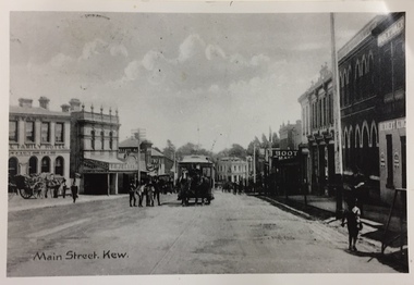 Kew Historical Society Inc
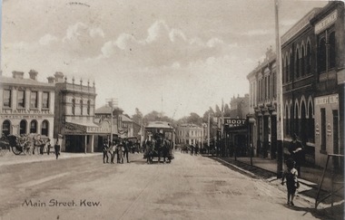
Postcard, Main Street, Kew
... tram - kew (vic) kew junction Reverse - "High St Kew looking ...Image copied from older postcard (c.1890-1900) showing horse drawn vehicles and a horse tram. Since then, the southern side of the street has been widened. Businesses identified in the photograph include the Ryan's Council Family Hotel, the Greyhound Hotel, the Clifton Hotel, the ES&A Bank and Jellis' Bakery. Black & white photograph of a postcard showing Main [High] Street, Kew looking south west showing horse drawn tram centre.Reverse - "High St Kew looking down from Post Office to Kew Junction"horse tram kew, clifton hotel - kew junction, ryan's council family hotel kew, horse tram - kew (vic), kew junction -
 Kew Historical Society Inc
Photograph, J F C Farquhar, High Street, Kew, 1891
At the beginning of the 1890s, the Kew businessman and Town Councillor, Henry Kellett, commissioned J.F.C. Farquhar to photograph scenes of Kew. These scenes included panoramas as well as pastoral scenes. The resulting set of twelve photographs was assembled in an album, Kew Where We Live, from which customers could select images for purchase.The preamble to the album describes that the photographs used the ‘argentic bromide’ process, now more commonly known as the gelatine silver process. This form of dry plate photography allowed for the negatives to be kept for weeks before processing, hence its value in landscape photography. The resulting images were considered to be finely grained and everlasting. Evidence of the success of Henry Kellett’s venture can be seen today, in that some of the photographs are held in national collections.It is believed that the Kew Historical Society’s copy of the Kellett album is unique and that the photographs in the book were the first copies taken from the original plates. It is the first and most important series of images produced about Kew. The individual images have proved essential in identifying buildings and places of heritage value in the district.In 1891, High Street was the centre of commercial activity in the Borough of Kew. It was unpaved and edged with deep bluestone gutters, which were designed to channel the significant flow of storm water down the hill to and beyond the Junction. On either side of the entrance to the shopping strip are two cast iron gas lamps that provided the only public street lighting before the Post Office was reached. Most shops, including the Nicholas Brothers’ Junction Store featured cast iron verandas. Further up the hill, Dougherty’s Greyhound Hotel was by this stage a local institution. Apart from the horse-drawn tram, the main form of personal and commercial transport in this period remained the horse, horse and cart, or buggy.The panoramic view predates the widening of High Street in the 20th century, and thus includes the original alignment of buildings on the south side. These included Henry Kellett’s shop.High Street, Kewkew illustrated, kew where we live, photographic books, henry kellett, high street - kew (vic) -
 Kew Historical Society Inc
Photograph - Harp of Erin Tram Terminus, c.1916
An electrified tram route from Melbourne along High Street replaced an original Horse Tram that terminated at the Kew Cemetery. This new tram only reached the bridge over the Outer Circle railway at the Harp Junction. The line was later extended to North Balwyn.Black and white print positive of the Tram Terminus in High Street, Kew at the Harp of Erin hotel. "Harp of Erin Tram Terminus about 1916. House on left still standing behind delicatessen [in 1978]. / Courtesy Mrs E Bennett, Kew East / Property of Miss Foley."tramways, mmtb, tram terminus, no 48 tram route, harp of erin hotel, trams - kew, trams - kew east -
 Kew Historical Society Inc
Photograph - Looking towards Kew from Strathalbyn Street and High Street, c.1916
An electrified tram route from Melbourne along High Street replaced an original Horse Tram that terminated at the Kew Cemetery. This new tram only reached the bridge over the Outer Circle railway at the Harp Junction. The line was later extended to North Balwyn.Black and white print positive showing the view west along High Street, Kew (formerly Bulleen Road). In the centre distance is the Boroondara General (Kew) Cemetery. In the foreground, the road crosses the Outer Circle railway. The photograph reflects the level of urbanisation in Kew during the First World War. "Looking towards Kew from Strathalbyn St / High St corner, about 1916. Courtesy Mrs E Bennett, Kew East / Property of Miss Foley"trams -- kew, trams -- kew east, mmtb, m&mtb, tramways, harp junction -
 Kew Historical Society Inc
Photograph - Harp of Erin Tram Terminus, 1977
An electrified tram route from Melbourne along High Street replaced an original Horse Tram that terminated at the Kew Cemetery. This new tram only reached the bridge over the Outer Circle railway at the Harp Junction. The line was later extended to North Balwyn.Black and white print enlargement of the Tram Terminus in High Street, Kew at the Harp of Erin hotel. The rear of the photograph identifies it as an enlargement donated by Stewart West from an original owned by Miss Foley.tramways, mmtb, tram terminus, no 48 tram route, harp of erin hotel, trams - kew, trams - kew east -
Kew Historical Society Inc
Journal, Kewriosity : November 1991
The Horse Tram returns to Kew [Kew Depot Open Day] / p1. Chief Executive's Comment [Kew Junction] / Malcolm Hutchinson p2. Mayor's Comment [Kew Junction Strategy Plan] / Cr Daryl Oldaker p3. Diary Dates for November / p4. Diary Dates for December / p5. The Lioness Club of Kew / p5. Market [Kew Community House] / p5. Invitation to Lawn Bowls [Auburn Heights Bowling Club] / p5. Leader Sports Challenge Camp / p6. New face [Heather Crichton] / p7. New Way Theatre [Company][Kew Cottages] / p7. Safe disposal of chemicals around the home [Disposal options - Waste type by location] / p8. Insects / Marlowe p9. Bothered by pests? [Improved and cheap pest control for Kew residents] / p9. Kewriosity advertising rates / p10. City of Kew Waste Disposal Services for 1991/92 / Malcolm Hutchinson p11. New mum presentation [Nursing Mothers' Association; St George's Hospital] / p12. Kew Auxiliary - Royal Women's Hospital / p12. L.Bear [Library Bear] / p13. Arthritis self help / p14. Mural [by Bill Wood] / p14. Old Trams [request for photos] / p14. Kew Info Youth / p15. Local Artist [Mary McQueen] / p15. Golden putter golf [Studley Park Golf Course] / p15. City of Kew Residential Policies Review Committee [update] / p16. Apology [Kew Community House program] / p16.Kewriosity was a local newsletter combining Kew Council and community news. It was published between November 1983 and June 1994, replacing an earlier Kewriosity [broad] Sheet (1979-84). In producing Kewriosity, Council aimed to provide a range of interesting and informative articles covering its deliberations and decision making, together with items of general interest and importance to the Kew community and information not generally available through daily media outlets.non-fictionThe Horse Tram returns to Kew [Kew Depot Open Day] / p1. Chief Executive's Comment [Kew Junction] / Malcolm Hutchinson p2. Mayor's Comment [Kew Junction Strategy Plan] / Cr Daryl Oldaker p3. Diary Dates for November / p4. Diary Dates for December / p5. The Lioness Club of Kew / p5. Market [Kew Community House] / p5. Invitation to Lawn Bowls [Auburn Heights Bowling Club] / p5. Leader Sports Challenge Camp / p6. New face [Heather Crichton] / p7. New Way Theatre [Company][Kew Cottages] / p7. Safe disposal of chemicals around the home [Disposal options - Waste type by location] / p8. Insects / Marlowe p9. Bothered by pests? [Improved and cheap pest control for Kew residents] / p9. Kewriosity advertising rates / p10. City of Kew Waste Disposal Services for 1991/92 / Malcolm Hutchinson p11. New mum presentation [Nursing Mothers' Association; St George's Hospital] / p12. Kew Auxiliary - Royal Women's Hospital / p12. L.Bear [Library Bear] / p13. Arthritis self help / p14. Mural [by Bill Wood] / p14. Old Trams [request for photos] / p14. Kew Info Youth / p15. Local Artist [Mary McQueen] / p15. Golden putter golf [Studley Park Golf Course] / p15. City of Kew Residential Policies Review Committee [update] / p16. Apology [Kew Community House program] / p16.publications -- city of kew (vic.), kewriosity, council newsletters, community newsletters -
 Kew Historical Society Inc
Photograph - Filling in the Outer Circle Railway cutting at East Kew, 1939
... of the railway cutting at the Harp Junction and shifting tram tracks... of the railway cutting at the Harp Junction and shifting tram tracks ...W.D. Vaughan (Kew's Civic Century, 1960, pp.195-6) quotes Council Minutes of 1938 and 1939 to record that: "After protracted negotiations between the Council, the Railways Department and the Tramways Board agreement was reached in June, 1938, for the filling of the railway cutting at the Harp Junction and shifting tram tracks to the High Street alignment ... The Outer Circle railway land from Princess Street to Park Crescent was purchased by the Kew Council in October, 1939, for 2,750 [pounds]. The land from Park Crescent to High Street was leased for 1 [pound] per annum. Considerable work was done in levelling the embankments to the original surface level."Important and rare photograph of the period, showing major works by Kew Council in Kew East working on a significant piece of urban infrastructure.Small, original black and white positive (photograph) showing workers and vehicles filling in the tracks of the former Outer Circle railway at East Kew. In the background is the metal bridge with brick piers, adjacent to the Harp Junction. The bridge crossed the cutting, linking the two parts of High Street. Behind the tip truck, painted on the side with the name 'Fowler Quarries' [located Keilor Road, North Essendon], one can see shops [including T.G. Garroway, Cash Grocer] in High Street. What appears to be the City of Kew Steamroller is immediately in front of the bridge. A group of passers-by watch from the bridge and from the road. Annotation in pencil on verso: "Filling in Outer Circle line at High St East Kew prior to straightening High St. (c. Feb 1930?)outer circle railway, railway cuttings, harp junction, high street -- kew east -
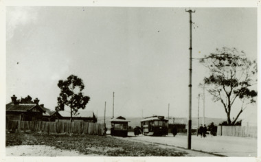
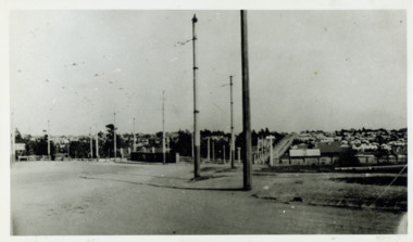
![Harp Junction [East Kew]](/media/collectors/550653872162f11fb04854aa/items/58cf089ed0ce9809d8713015/item-media/58cf59f9d0ce603314508da0/item-fit-380x285.jpg) Kew Historical Society Inc
Kew Historical Society IncPhotograph, Harp Junction [East Kew], 1910-1930
The Harp Junction, East KewAnnotations on reverse "KH-73. View from Junction of High St (then Bulleen Rd.) & Strathalbyn St. Kew. Looking toward Boroondara Cemetery. Wall in picture is side of bridge over Outer Circle Railway. Trams later cut across this curve."high street (kew), strathalbyn street (kew east), harp of erin hotel (kew) -
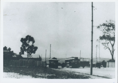
![Harp Junction [Kew East]](/media/collectors/550653872162f11fb04854aa/items/58cf094bd0ce9809d8715cf3/item-media/58cf59d0d0ce5d331467358d/item-fit-380x285.jpg) Kew Historical Society Inc
Kew Historical Society IncPhotograph, Harp Junction [Kew East], 1910-1930
Kew Junction at this stage was a tram terminusThe Harp Junction, East Kew.Annotation on reverse: "East Kew - looking towards city from harp of Erin Hotel - note wooden fence."harp of erin hotel (kew), high street (kew) -
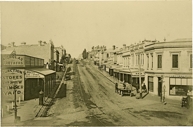
 Kew Historical Society Inc
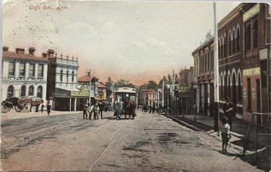
Postcard, Main Street, Kew, c.1890
The Kew Historical Society's Pictures Collection is comprised of photographs, postcards and original works of art. The postcards include original (mainly) images dating from the 1900s to the present. A number of postcards, some of which have numerous variants, were published as parts of series. Others are original images customised as postcards. Many of the postcards in the collection depict places within the suburbs of Kew and Kew East. Others depict locations in Victoria or internationally. A monochrome postcard showing Main Street [High Street], Kew, looking south west from near its junction with Cotham Road, showing: Ryan’s Council Family Hotel, T. G. Jellis (baker, confectioner), Herbert King (undertaker), L. Merritt (boot warehouse), horse tram, horse drawn vehicles and pedestrians.Post card text addressed to Miss Newell of Balmain.high street - kew, cotham road - kew, tramways - kew -
 Kew Historical Society Inc
Postcard, High Str., Kew, c.1906
The Kew Historical Society's postcard collection includes views of Kew, Melbourne and Greater Melbourne as well as those including overseas scenes sent or received from Europe or the Middle East. They date from the 1890s to the 2000s. These postcards may or may not include the name of the publisher or printer. A number of the cards were published as parts of popular series. A way of dating early postcards is to identify whether the reverse was divided by a central line which became the norm after 1902 in the United Kingdom. However, other postcards produced after this date do not always conform to this print layout.Polychrome postcard of High Street, Kew looking west towards Kew Junction. The photograph was also printed in monochrome format by the publishers, with different names and additions.Reverse - (to) Miss __. J. Thompson, "Dry Lake", Kerang (from) Very sorry indeed to hear of your Mother's illness. Sincerely hope all quite well ere this. Still going about very tired waiting __ being away. Love to all M.B.L.high street -- kew (vic.), postcards -- kew (vic.), horse tram -- kew (vic.) -
 Kew Historical Society Inc
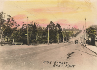
Postcard - High Street, East Kew, c.1927
High Street, Kew is the main Road in Kew. It was once also known as Bulleen Road, or Main Street. This section of the road is in Kew, although the narrow section on the right hand side of the photo is now Kew East. High Street progresses through a number of significant road junctions: beginning at Barkers Road; progressing through the intersection of Studley Park Road, Denmark Street and Princess Street at Kew Junction; branching left at the junction with Cotham Road; before reaching the junction with Valerie Street and Harp Road. It reaches its end at the junction of Burke Road, Kilby Road, Bulleen Road and High Street itself. An early photograph of this iconic Memorial that locates it in its context. Small, colorised real photo postcard of High Street, East Kew. Electric light poles line the road. Victoria Park is on the left and further on the horizon is the Boroondara General Cemetery.high street -- kew (vic.), victoria park, tram lines -- kew (vic.) -
 Melbourne Tram Museum
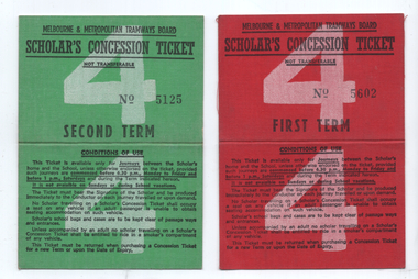
Ephemera, Melbourne & Metropolitan Tramways Board (MMTB), Scholar's Concession Ticket - 1st & 2nd term, 1962
Ticket allowed Scholars or school children to travel on MMTB trams/buses to attend schools at a concession rate. Inside gives issue details - issued to a person in Glen Iris, four sections, for use during 1962, from Camberwell Junction to the Methodists Ladies College in Barkers Road Cost 44/- Ticket No. 5125 and 5602. See item 7776 for the 3rd term ticket from the same donor.Demonstrates a Scholar's ticket to allow a student to travel from Camberwell Junction to Barkers Road.Set of two clothed-backed paper ticket, printed as a MMTB "Scholar's Concession Ticket", 1st term - red, 2nd term green. Gives condition of use on the outside cover. Details filled in of the person's name address etc.mmtb, tickets, schools, scholar's tickets, school tickets -
 Melbourne Tram Museum
Drawing - Set of 5, Melbourne Metrorail, "Melbourne Metro St Kilda Road - early works", 10/2016
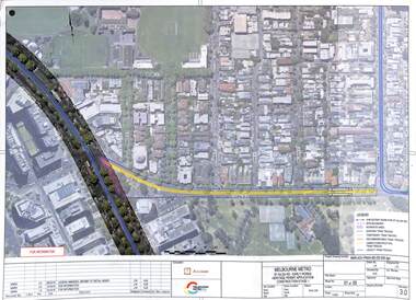
... work stages principally at the site of Domain Junction where... work stages principally at the site of Domain Junction where ...Drawings prepared by the Melbourne Metro project to show the relocation of Domain Interchange, Domain Road and Park St South Yarra to Toorak Road West and St Kilda Road. Drawings prepared for a Heritage Victoria application dated 26/10/2016. Shows the various work stages principally at the site of Domain Junction where the tram tracks had to be relocated to facilitate the construction of Anzac station.Yields information about the relocation of Domain Interchange to facilitate the construction of the Melbourne Metro.Set of five laminated A3 colour prints with a punch hole in the top left hand corner.metro tunnel, domain interchange, domain road, toorak road, st kilda road, heritage victoria, anzac station -
 Melbourne Tram Museum
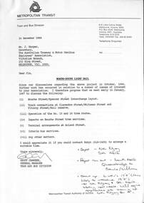
Letter, Metropolitan Transit Authority (MTA), "North - South Light Rail", 12/1986
Letter from Geoff Carkeek, MTA Tram and Bus Division General Manager to J Harper, Secretary ATMOEA dated 24/12/1986 regarding the North - South Light Rail proposal (St Kilda and Port Melbourne lines) and the conversion to light rail, and impacts on existing tram services. Includes a note on the proposed termination of route 15 and 16 trams at St Kilda Railway station. Includes two drawings - St Kilda Station - Fitzroy St using the former VR St Kilda station forecourt rather than the platforms which were actually later used, and Clarendon St - Port Junction layout.Yields information about the conversion of the St Kilda Railway project.Letter - photocoped - 6 A4 and 2 A3 folded sheets, part stapled.light rail, conversion, st kilda, port junction, atmoea, st kilda railway station -
 Ballarat Tramway Museum
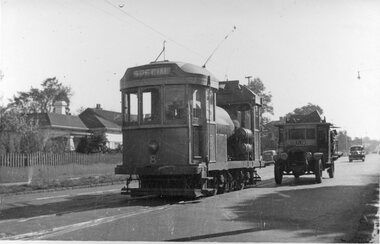
Photograph - Scrubber 8, Caulfield Junction, 24-8-1950
Black and white photograph of MMTB Scrubber No 8 at Caulfield Junction. No details as to the photographer. Taken 24-8-1950. This tram is the BTM's track cleaner or scrubber.Yields information about the use of Scrubber tram No. 8Photograph, black and white with notes on rear.In pencil on the rear "Caulfield Junction - 24-8-1950"tramways, trams, tram 8, scrubber, caulfield -
 Melbourne Tram Museum
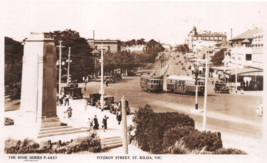
Postcard, Rose Stereograph Co, "Fitzroy Street St Kilda Vic", late 1930s
Rose Series postcard No. P 4827 titled "Fitzroy Street St Kilda Vic" showing two W2 class tramcars at the intersection of Fitzroy Street and The Esplanade St Kilda. Tram W2 class No. 362 is inbound while W2 548 is outbound to St Kilda Beach at Ackland Street. The St Kilda Cenotaph, dedicated on 25th April 1925, and a small part of the Catani Gardens are on the left side. Tram Route number boxes appear to not be in use yet and W2 No 548 look very new with its unique St. Louis EIB64 trucks (bogies) . St. Kilda Junction appears in the distant background. Yields information about Fitzroy Street, St Kilda early1930s.Postcard - printed real photograph with Rose Stereograph Co. name on the rear and remnants of blue card on the rear.trams, tramways, w2 class, tram 362, fitzroy st, st kilda, the esplanade, tram 548