Showing 5313 items
matching flood-marker-orbost
-
 Kew Historical Society Inc
Photograph - River Yarra in Flood from Kilby Road
Flooding of the Yarra Valley, including that section of the Yarra bordering Kew and Kew East in the north and west of the municipality, was a regular occurrence. Extreme flood events of the Yarra River are recorded to have occurred in 1891, 1901, 1916, 1923 and 1934. The Municipality of Kew's response to these floods was to enact planning decisions restricting residential development in flood prone areas following the floods of 1916, 1921 and 1934. While floods continued after the development of the Upper Yarra Reservoir (construction 1948-57), the regularity and extent of these inundations diminished.Print copy of an original photo of the River Yarra in Flood, taken from Kilby Road.VIEW ACROSS YARRA IN FLOOD / FROM KILBY RD KEWkilby road, floods -- kew (vic.), kilby farm -
 National Wool Museum
Photograph, Yarra Falls: Yarra River in Flood
James Murgatroyd worked at Warrnambool Woollen Mills, Federal Mill, Tweedside, Collins Mills and set up looms for Alexander Spinning Mills Sydney, his son Fred Murgatroyd worked as a loom tuner at Yarra Falls, Tweedside and Collins mills in Victoria as well as in Sydney, and studied at Leeds University.Murgatroyd Photograph CollectionF Murgatroyd Yarra Falls: Yarra River in Flood KODAK PRINTtextile machinery textile mills textile mills, yarra falls mill, murgatroyd, mr fred murgatroyd, mr james, textile machinery, textile mills -
 Ringwood and District Historical Society
Photograph, Mullum Creek in flood, July 1963. Taken from foot bridge at end of Adelaide St., Ringwood
See also 2982Typed below photograph, "Mullum Creek in Flood - 1963". Other photographs read, "Mullum Creek in flood, July 1963. Taken from foot bridge at end of Adelaide St." -
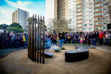 Yarra City Council
Artwork, other - Marker, Reko Rennie, Remember Me: Stolen Generations Marker, 2018
Kamilaroi artist Reko Rennie’s vision is an inclusive environment where people can sit and peacefully reflect on, mourn and acknowledge the deep trauma of the past, as well as connect with the ongoing strength and resilience of the Aboriginal community and support the process of healing. 'Remember Me' symbolises community resilience, identity and family. Positioned in a ceremonial ring, the seating and spears create a circle of gathering and remembrance within the park. In a contemporary and historical sense, the spear is an emblematic statement about struggle and adversity, and it is also an expression of identity and connection to land and culture.The 'Stolen Generations Marker, Remember Me', reflects the community’s wish to create a permanent tribute to the Stolen Generations and their families; a place of reflection and respectful commemoration. Integral to this is the surrounding garden with plants local to the area that have been re-introduced into the setting. Sited at the historically important Meeting Place in the heart of Aboriginal Fitzroy, the artwork honours not only the story of this place, but of all Aboriginal people who were taken away. This project was guided by the Stolen Generations Marker Steering Group and realised by Yarra City Council in partnership with the Victorian Government. Most importantly, it has received widespread grassroots community support. It was officially launched on the 20th anniversary of National Sorry Day (26 May 2018), which acknowledges the impact of the policies spanning more than 150 years of forcible removal of Aboriginal and Torres Strait Islander children from their families. On 26 May 1997 the landmark 'Bringing Them Home' report was tabled in Federal Parliament. The report was the result of a national inquiry that investigated the forced removal of Indigenous children from their families. This was a pivotal moment for many Stolen Generations. It was the first time the stories of forced removal were formally acknowledged by the Government and a recognition that these actions were inhumane. The impacts have been lifelong and intergenerational. A collection of bronze spears and a coolamon with accompanying seating, lighting and landscaping positioned in a ceremonial ring.stolen generations, fitzroy -
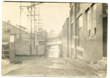
 Orbost & District Historical Society
black and white photograph, February 1971
This photograph was taken near the Snowy River Bridge on the the old Princes Highway in Orbost, near the caravan park. The 1971 flood was the the worst flood on record. At Jarrahmond it was at least 11 metres and up to one and a half kilometres wide on the flats causing enormous damage to the flood plain. Records say that "The brown floodwater stain in Bass Strait could be seen from passing airliners." Considerable damage was done to railway infrastructure, roads and farms. More information from the APRIL, 2008 newsletter by John Phillips. (see orbosthistory.com.au)This is pictorial evidence of a significant local event. Floods have been an integral part of Orbost's history for hundreds of years.A black / white photograph of debris, fallen power lines, a tree across the highway and floodwaters across the road.on front at bottom - handwritten in upper case print - " 1971 FLOOD PRINCES HIGHWAY NEAR SNOWY BRIDGE"floods-orbost-1971 -
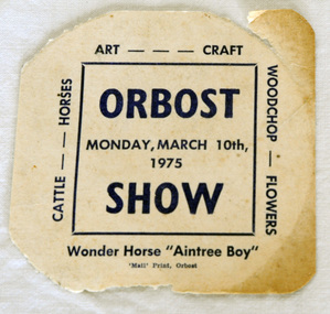 Orbost & District Historical Society
ticket, 1975
Owen 'Doc' Matthews is remembered for his spectacular Grand Prix dressage exhibitions with his horse Aintree Boy, performed to music under spotlights at Melbourne Royal Show from 1965-1975. He also performed at smaller country shows. Doc Matthews was born in the Melbourne suburb of Fitzroy in 1923, during the Great Depression. He and his brother Paddy were placed in a foster home and then in a Geelong orphanage before being put to work at a dairy farm. Doc was given an elderly piebald mare to ride, which ignited his passion for horses. When he was 16, he enlisted in World War 2 but captured by the Japanese and ended up working on the Burma Railway, spending years as a prisoner of war in the notorious Changi Prison. Doc joined Victoria Police in 1952 and by 1962 was chief horse master and riding instructor in the mounted branch. He drilled teams to perform musical rides and horses and riders were always turned out to perfection. Doc and Aintree Boy became a partnership after the horse had been used in the mounted branch for four years. Doc decided to try his hand at dressage and as there were few instructors, trained Aintree Boy with nothing to go by but a couple of books and film of a single dressage competition. Owen 'Doc' Matthews was truly a pioneer of Grand Prix dressage in Australia. ( ref. TOPHORSE )Agricultural shows are an important part of cultural life in small country towns and the Orbost Show is an integral part of Orbost 's agricultural history.A square shaped ticket for Orbost Show - Monday, March 10th 1975. It is on white card with blue print.Orbost Wonder Horse "Aintree Boy". Monday, March 10th 1975aintree-boy dressage equestrian matthews-owen -
 Orbost & District Historical Society
black and white photographs, 1977
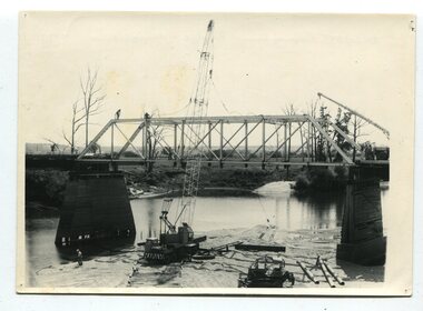
This is a series of photographs of the demolition of the 1922 bridge across the Snowy River at Orbost. This bridge over the Snowy River was opened on July 4 1922. It was constructed in 1922 alongside the previous suspension bridge. Its building was a combined effort of the Victorian Railways and the Country Roads Board at a cost of 35,000 pounds. It was replaced in 1976 by the present bridge after several major floods.This bridge was replaced in 1976 after several major floods. These photographs record the demolition of that bridge.Ten black / white photographs of a road bridge demolition. In the photographs are cranes, one on a barge, and workmenon back - Orbost Snowy River Bridge demolition 1977 -
 University of Melbourne, Burnley Campus Archives
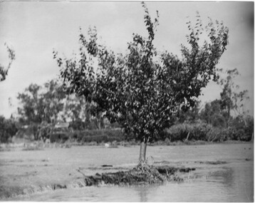
Photograph - Black and white print, Orchard After Flood, 1934
Black and white photograph. Orchard after flood: shows single fruit tree surrounded by water. Enlargement.orchard, yarra river, floods, 1934, fruit tree -
 Lakes Entrance Historical Society
Book, East Gippsland Catchment Management, Flood Event Photos 2007, 2007
A pictorial record in colour of the widespread damaging floods in East Gippsland in June 2007 . Spiral bound bookletnatural disasters, waterways, township -
Lakes Entrance Historical Society
Book, Glenvale School Committee, From Fire to Flood, 2007
A pictorial record which graphically represents the devastation caused by fire and flood in Gippsland during 2006-2007.natural disasters -
 Orbost & District Historical Society
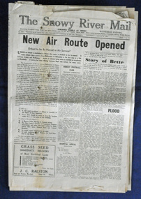
newspaper, Snowy River Mail, 29.3.1950
The Snowy River Mail is a weekly newspaper published in Orbost in the Shire of East Gippsland, Victoria, Australia. Previously published as The Snowy River mail and Tambo and Croajingolong gazette from 1890 to 1911. The Gippsland Courier merged with the Snowy River Mail when proprietor Lachlan Ross moved to Orbost in 1910. In 1999 the paper was acquired by the Yeates family when the Hollins family retired from the newspapers business. The paper is still being produced by the fourth generation of the Yeates family as part of East Gippsland Newspapers. The 1950 flood was a significant event in Orbost. This newspaper is a contemporary record of a significant local events.A Snowy River Mail newspaper dated 29.3.1950. It contains news articles and advertisements in black/white print. it contains an article on the flood at that time.snowy-river-mail 1950-flood newspaper -
 Orbost & District Historical Society
newspaper clippings, February 1971
These articles were compiled by Mary Gilbert who was the first curator of the Orbost Museum and a prominent historian / teacher in Orbost. The 1971 floods at Orbost were the worst on record. At Jarrahmond the river rose to a height of 11 metres and on the flats spread to one and a half kilometres wide. Considerable damage was done to railway infrastructure, roads and farms. More information from the APRIL, 2008 newsletter by John Phillips. (see orbosthistory.com.au)These articles are contemporary records of a significant historical event in Orbost.A manila folder containing black / white newspaper clippings from various publishers. They all relate to the 1971 floods in Orbost. (Details of contents in catalogue 735-900)floods-orbost-1971 -
 Kew Historical Society Inc
Photograph - Yarra Valley Floods: Kew East, 1916
Flooding of the Yarra Valley, including that section of the Yarra bordering Kew and Kew East in the north and west of the municipality, was a regular occurrence. Extreme flood events of the Yarra River are recorded to have occurred in 1891, 1901, 1916, 1923 and 1934. The Municipality of Kew's response to these floods was to enact planning decisions restricting residential development in flood prone areas following the floods of 1916, 1921 and 1934. While floods continued after the development of the Upper Yarra Reservoir (construction 1948-57), the regularity and extent of these inundations diminished. During the nineteenth century, the land abutting the south side of the Yarra in Kew was devoted to dairy farming. In the twentieth century, before and after the construction of the Eastern Freeway, much of this low-lying area was used as golf courses and public parks.One of a collection of photographs of flooding in the Kew section of the Yarra Valley which are in important research resource for the location and extent of flooding in the first half of the twentieth century. Flooding of the Yarra Valley at East Kew in 1916. The view is taken from a street (maybe Birdwood Avenue) intersecting with Kilby Road looking northeast across the flood waters to Ivanhoe and Heidelberg. The extensive flooded area shown in the photograph would have included remnant dairy farms and the Kew Golf Club. Verso: "Floods / Yarra River / East Kew / Kilby Road / 1917? / 87"yarra river, yarra valley, floods -- kew, kilby road -- kew (vic.), kew golf club -
 Orbost & District Historical Society
black and white photograph, August 1897
This is a photograph of the bridge from the Orbost side. The first pile bridge over the Snowy River was just completed by Mr Jim Granter when the 1891 flood took out the centre,. There were differences of opinion as to whether the council should pay . The Shire Secretary, Mr John Draffin, persuaded them to honour their obligations. Mr Granter and Mr Clarke finished it as a suspension bridge which was opened by Mrs William Watt. Soon after a mob of cattle stampeded, the weight snapped the cable, letting one side sag. Mr R.P. Cameron repaired it and this bridge remained until 1922. "In 1890 the contract for a bridge was let to Mr James Granter for £1450. This structure with additions and improvements made to it was to cost the ratepayers about £2,500, and its erection was proceeded with in a very satisfactory manner until, just as the greater-part of the work had been completed, the flood of 1891 came down on it, piling up mountains of logs, timber and debris against the piers, which had not been made wide enough apart to allow for. contingencies of this kind. The structure held out bravely until the turn of the flood and then gave way with a crash, about five bays from the centre disappearing in the stream." ( Snowy River Mail August 12 1893) This item is a pictorial record of one of the first bridges across the Snowy River in Orbost.A black / white photograph of the old wooden suspension bridge over the Snowy River. There are two copies 919.1 and 919.2. There are two other photos showing the whole bridge taken from further back.on back - "Orbost Bridge...."snowy-river-bridge-orbost granter-james -
 Kew Historical Society Inc
Photograph - Yarra Valley Floods: Kew East, 1916
Flooding of the Yarra Valley, including that section of the Yarra bordering Kew and Kew East in the north and west of the municipality, was a regular occurrence. Extreme flood events of the Yarra River are recorded to have occurred in 1891, 1901, 1916, 1923 and 1934. The Municipality of Kew's response to these floods was to enact planning decisions restricting residential development in flood prone areas following the floods of 1916, 1921 and 1934. While floods continued after the development of the Upper Yarra Reservoir (construction 1948-57), the regularity and extent of these inundations diminished. During the nineteenth century, the land abutting the south side of the Yarra in Kew was devoted to dairy farming. In the twentieth century, before and after the construction of the Eastern Freeway, much of this low-lying area was used as golf courses and public parks.One of a collection of photographs of flooding in the Kew section of the Yarra Valley which are in important research resource for the location and extent of flooding in the first half of the twentieth century. Flooding of the Yarra Valley at East Kew in 1916. The view is taken from the intersection of Kilby Road with what is believed to be Birdwood Street, looking across the flood waters to Ivanhoe. The extensive flooded area shown in the photograph would have included the Kew Golf Club. Verso: "Floods along Kilby Road / near Birdwood St? & Kilby Road / 1917? / 87yarra river, yarra valley, floods -- kew, kilby road -- kew (vic.), kew golf club -
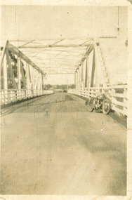 Lakes Entrance Historical Society
Photograph - Bridges, 1940
After 1934 flood damage to second bridge, centre pile was replaced by a truss girder, this survived until 1971 floodBlack and white photograph showing second Orbost Bridge over the Snowy River, wooden planks, railing and overhead support. Motor bike leaning on railing at near end of bridge. Orbost, Victoria.bridges, waterways -
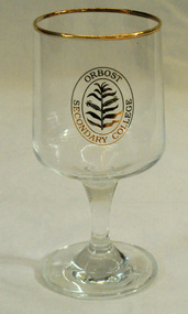 Orbost & District Historical Society
drinking glass, 1990
This glass was produced as a souvenir following the name change from Orbost High School to Orbost Secondary College in 1990.Orbost High School / Orbost Secondary College has played a significant part in the education of senior students in the Orbost district . It is the sole senior educational institution. This souvenir drinking glassis representative of its history.A clear drinking glass with a stem and base stand produced as a souvenir of Orbost Secondary College. Tt has a gold rim and the school badge is pirinted in gold on the outside of the glass.Orbost Secondary Collegesouvenir orbost-secondary-college -
 Kew Historical Society Inc
Photograph - Flood at Fairfield Park, 1934
Flooding of the Yarra Valley, including that section of the Yarra bordering Kew and Kew East in the north and west of the municipality, was a regular occurrence. Extreme flood events of the Yarra River are recorded to have occurred in 1891, 1901, 1916, 1923 and 1934. The Municipality of Kew's response to these floods was to enact planning decisions restricting residential development in flood prone areas following the floods of 1916, 1921 and 1934. While floods continued after the development of the Upper Yarra Reservoir (construction 1948-57), the regularity and extent of these inundations diminished.Black and white print positive. Yarra River at Fairfield in 1934. Major flood resulting in submerged buildings in middle ground and onlookers on far bankReverse: "Flood of Yarra at Fairfield Park 1934"fairfield park, yarra valley, river yarra, floods -- 1934 -
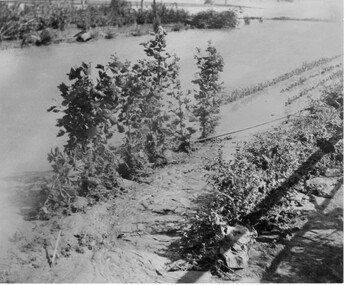
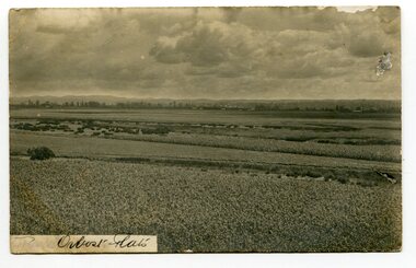 Orbost & District Historical Society
black and white photograph, Sherwood, first half 20th century
This postcard is addressed to Tom Lloyd from Uncle Frank c/o F. Lloyd Esq, Bairnsdale.This item is a pictorial record associated with the agricultural history of Orbost. .The extensive Snowy river flood plain was swampy, but by the 1880s the river flats were being drained. The Orbost flats are very fertile and crops were planted on the rich deep soil, with maize rapidly becoming widespread.A black / white photograph of the Orbost farming flats. The sky is very cloudy. There are paddocks of crops in the foreground.on front - "Orbost Flats" on back - "How are you enjoying your holiday.......Uncle Frank"orbost-flats-farming lloyd-frank -
 Orbost & District Historical Society
photographs, C1920's- 1930's
These are photos of the second Orbost Butter Factory built in 1916 in Forest Road Orbost.These photos are pictorial records of the Orbsot Butter Factory.Two b/w postcards of the Orbost Butter Factory. Both are copies of the originals.2627.1 on back ; John Scouller and Jo Cross standing behind grave of Dan the Cookorbost-butter-factory -
 National Wool Museum
Photograph, Yarra Falls: Yarra flood, early 1930's
James Murgatroyd worked at Warrnambool Woollen Mills, Federal Mill, Tweedside, Collins Mills and set up looms for Alexander Spinning Mills Sydney, his son Fred Murgatroyd worked as a loom tuner at Yarra Falls, Tweedside and Collins mills in Victoria as well as in Sydney, and studied at Leeds University.Murgatroyd Photograph CollectionF Murgatroyd Yarra Falls: Yarra flood, early 1930's KODAK PRINTtextile machinery textile mills weaving mills textile mills, yarra falls mill, murgatroyd, mr fred murgatroyd, mr james, textile machinery, textile mills, weaving mills -
 Ringwood and District Historical Society
Photograph, Ringwood Bowling Club- Installation of flood wall along the Miles Avenue frontage, 1979
Black and white photographs (2)Photographs show volunteers constructing the flood wall along the Miles Avenue frontage. Text attached to photos includes names of Committee Members who accepted the responsibility of recommending changes in 1979 including the flood wall. -
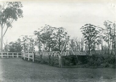
 Orbost & District Historical Society
black and white photographs, C1970
These photographs are of the 1922 road bridge across the Snowy River at Orbost. This bridge over the Snowy River was opened on July 4 1922. It was constructed in 1922 alongside the previous suspension bridge. Its building was a combined effort of the Victorian Railways and the Country Roads Board at a cost of 35,000 pounds. It was replaced in 1976 by the present bridge after several major floods.This bridge was replaced in 1976 after several major floods. These photographs are pictorial records of the 1922 brige.Two small black / white photographs of a road bridge across a river. 3248.1 is a close-up of wooden pylons.on label on back - "Snowy River Bridge at Orbost 1922 Bridge"bridge-orbost snowy-river-bridge -
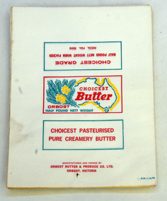 Orbost & District Historical Society
wrappers
Used to wrap half pound packs of butter made at the Orbost Butter Factory.The Orbost Butter and Produce Co. Ltd was registered on June 1st 1893 and was an important source of income to the Orbost district. .1 is a bundle of twenty wrappers for Orbost Choicest Butter -Half Pound Nett Weight. They are white, rectangular with yellow,red ang green print . .2 is two blank letter heads for Orbost Butter and Produce Co LtdManufactured and Packed by C.M. -L/FD Orbost Butter & Produce Co Ltd in bottom Orbost Victoria R.H. cornerorbost-butter-factory agriculture farming letter-head wrappers butter -
 University of Melbourne, Burnley Campus Archives
Photograph - Black and white print, Orchard in Flood, 1934
Black and white photograph. Orchard in flood: an irrigation ? Pipe is showing. Yarra River broke its bank on the night of 30.11.1934.orchard, yarra river, floods, 1934 -
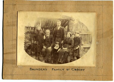 Orbost & District Historical Society
black and white photograph, C1888 -1889
This is a photograph of the Saunders Family at Orbost 1888-89. It is Arthur and Agnes Saunders with their children, Beatrice, Cyril, Hilda and Vera. Arthur Scott Saunders was born 1864 in Orbost and died 3.12.1913 in Orbost where he is buried. He was the son of Son of Thomas Frederick Saunders and Lucy Beard Scott. He was a storekeeper at Orbost, a member of the early Show Committees, a Rechabite in 1893, and was a member of the Board of Guardians of the Church of England from 1894 to 1913 where he served as secretary and treasurer of the Board. His wife was Agnes Louisa Stuart Morriss who was born in 1862 and died 26-11-1938 at East Malvern and is buried in . Orbost cemetery. She sold the business in 1919 to Mr J. H, V. Dale. She left Orbost with her two daughters for East Malvern in April 1927. Saunders General Store was opened in 1900, overlapping part of the present Mensland and Coultons. The ―Melbourne Store‖ refers to it being a branch of their Melbourne store. The shop was burnt down in the early 1930‘s. ( info. from Saunders Family Newsletter by John Phillips)This is a pictorial record of a prominent early Orbost family and is a useful research item.A black / white photograph of a family group with the parents seated and their children standing around them. In the background is a wooden fence. It is on a beige coloured buff card.on front - "Saunders family at Orbost" on back - " Saunders family at orbost, 1888 - 1889"saunders-orbost -
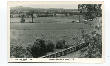 Orbost & District Historical Society
black and white postards, Rose Stereograph Company, 1940s -1950s
These postcards are part of the Rose series of photograph / postcards taken around Victoria. Rose was born in Clunes in 1861 and later worked in his father’s boot-making business in Prahran while studying photography. In 1880 he founded the Rose Stereograph Company and became famous for producing stereographs, or stereoviews, which gave the illusion of being in 3D when seen through a hand-held viewer, a big craze of the era. Rose produced stereoviews of the Western Front during the First World War. In all, he took about 9000 images in about 38 countries. As stereographs lost popularity in the 1920s, Rose switched to production of postcards and decorative cards, and he and the photographers who followed took thousands of scenes around Victoria as well as interstate that became iconic images of Australian life.These postcards are pictorial records of Orbost in the mid 20th century.Postcards such as these were a way of showing the scenic attractions of Orbost to potential tourists.Three black / white postcards of views over the Orbost flats and railway viaduct. 3183.1 is of a railway viaduct in the foreground and farming flats. 3183.2 is a view over the Orbost flats taken from Grandview Lookout. 3183.3 is a view from the Grandview Lookout showing the back of a woman looking across a rail fence. 3183.1 - bottom front - Rose Series P 478 SNOWY RIVER FLATS, ORBOST VIC 3183.2 - bottom front - Rose Series P 49 ORBOST, FROM GRANDVIEW HEIGHTS,VIC 3183.3 - bottom front - Rose Series P 14443 A VIEW FROM THE LOOKOUT, ORBOST, VICpostcards-orbost rose-series orbost-railway-viaduct grandview-lookout-orbost -
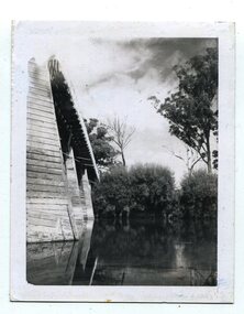
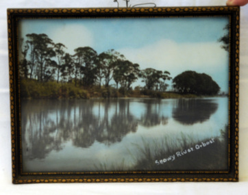 Orbost & District Historical Society
photograph, 1937
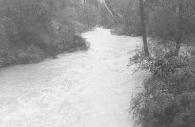
The photo was probably taken by Will Herbert and used at the 1937 "Back to Orbost" celebrations. The photo depicts the Snowy River at Orbost when it was at a high level.A coloured photograph in a brown wooden frame which has gold painted decorated edges. A wire hanger is attached. The photo shows reflections of trees along the bank of the Snowy River in 1937.On bottom right of photo - Snowy River Orbost On back of frame - Back to Orbost 1937 from Will Herbertphotography snowy-river orbost-1937 -
Tatura Irrigation & Wartime Camps Museum
Photograph - copy, 1955 Floods, 1955
Copy of photograph of floods outside Tacey's Garage, Tatura.Black and white photograph of floods, outside Tacey's Garage, 1955.on back: Tacey's garage, Tatura. Corner Park and Hogan Streets. 1955 Floods.1955 floods tatura -
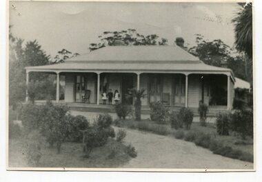 Orbost & District Historical Society
black and white photograph, early 20th century
The McLeods, were the original holders of the Orbost station. Sir William Clarke bought the station from McLeod Bros. Sir William was a very fine man and noted for his philanthropic actions. He finally cut up and sold the Orbost station and presented 10 acres of land to the people of Orbost for a show and recreation ground. Sir William Clarke had taken over the Orbost run from the McLeods in 1870. (more info. July 2006 Newsletter) When Sir William died the property was owned by his son, Rupert who offered the land for sale at 4 pounds per acre. No sale resulted and the property was leased for a few years until in 1898 it was subdivided and sold to many of Orbost's first families. (info. from In Times Gone By- Deborah Hall) This house was located on the western side of Forest Road. Orbost.This is a pictorial record of one of the first residences in Orbost.A black/ white photograph of a large wooden house. It has a verandah at the front and sides. There are three children two girls and a boy - standing on the verandah to the left of the door. The house is surrounded by gardens.on front - Orbost Home Stationorbost-station clarke-william clarke-rupert