Showing 22448 items
matching inverness-shire
-
 Stawell Historical Society Inc
Medallion, Victoria Jubilee 1887 Shire of Stawell, 1867
Commemorative item of Queen Victoria's Jubilee. Issued by Stawell shire. May have been given to school Children.Tarnished Medallion "Brass"Obverse - Victoria Jubilee 1887 - Young Head Left Profile. Reverse - Shire of Stawell T.H. Hutchings J.P President [Raised engraving of the Shire Hall]queen victoria jubilee -
Clunes Museum
Financial record - LEAFLET, Shire of Talbot & Clunes
The Shire of Talbot & Clunes is now part of Hepburn ShirePrinted leaflet containing information about the Shire of Talbot & Clunes Council's financial revenue and expenditure, (Ratepayer Report 1973)ratepayer's report, shire of talbot & clunes -
 Linton and District Historical Society Inc
Photograph, Hornby Studio Ballarat, Crowd outside new Shire of Grenville building for opening of new Shire Offices in 1939
Black and white photograph of a crowd of men, women and children posed outside a brick building."New Shire hall".buildings, grenville shire council, shire offices linton, events -
 Federation University Historical Collection
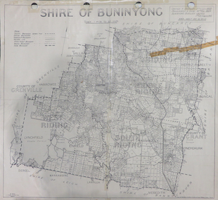
Map, Shire of Buninyong, c1970
The Shire of Buninyong was located on the southern side of Ballarat.Two maps of the Shire of Buninyong. .1) Map showing the County divisions, township boundaries, Railway line, State Forest boundary, riding boundary and shire boundary. Identifying words have been added in red and green texta. .2) Shire of Buninyong Parish Plan. Includes Buninyong, Clarendon, Narmbool, Enfield, Lychfield, SCotchman's, Navigators, Warrenheip, Scotsburn, mr Doran, Durham Lead, Cambrian Hill, Napoleons, Garibaldi, Mt Clear, Lal Lal, Bonshaw.1) B.I.A.E., St Martin's, cemetery, mt Buninyong, mt Innes, rly stn shire of buninyong, buninyong, clarendon, narmbool, enfield, lychfield, scotchman's, navigators, warrenheip, scotsburn, mt doran, durham lead, cambrian hill, napoleons, garibaldi, mt clear, lal lal, bonshaw, state forest, elaine, elaine north, cargerie, grenville, mt mercer, millbrook, wallace, yendon, canadian, kaolin deposits, mount helen campus -
 Orbost & District Historical Society
Invitation, 1969
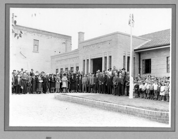
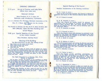
The current building was opened on Friday 28th February 1969 by the Premier of Victoria, The Hon. Sir Henry E. Bolte, K.C.M.G., M.P. The Shire of Orbost was a local government area about 380 kilometres east of Melbourne, the state capital of Victoria, Australia. The shire covered an area of 9,347 square kilometres and existed from 1892 until 1994. Originally, Orbost was part of the Bairnsdale Road District which was created on 30 April 1867. Splitting away as part of the Shire of Tambo in 1882, Orbost was first incorporated as a shire in its own right as the Shire of Croajingolong on 30 May 1892. It received its present name on 17 February 1893. On 3 January 1913 part of its western riding was annexed to Tambo as its Cunninghame Riding. Local governments play an important role in the lives of citizens in Australia. Local government authorities exist to provide services and amenities to local communities, and are also responsible for regulating and providing services for land and property in their district. This item is representative of a time when Orbost had its own Shire Council. A stapled program and invitation to the official opening of the new Orbost Shire Council Municipal Offices. A light blue card with the Orbost Shire Council insignia and gold print on front. The invitation is addressed to the secretary of Orbost Historical Society Judith Walcott.handwritten in blue pen - "Judith G Walcott"orbost-shire-council -
 Orbost & District Historical Society
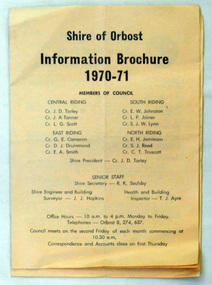
brochures, Snowy River Mail as "Mail" Print, Shire of Orbost Information Brochure, December 1970
The Shire of Orbost was a local government area about 380 kilometres east of Melbourne, the state capital of Victoria, Australia. The shire covered an area of 9,347 square kilometres ), and existed from 1892 until 1994. Originally, Orbost was part of the Bairnsdale Road District which was created on 30 April 1867. Splitting away as part of the Shire of Tambo in 1882, Orbost was first incorporated as a shire in its own right as the Shire of Croajingolong on 30 May 1892. It received its present name on 17 February 1893. On 3 January 1913 part of its western riding was annexed to Tambo as its Cunninghame Riding. On 2 December 1994, the Shire was abolished, and merged with City and Shire of Bairnsdale, Shire of Tambo, most of Shire of Omeo and the Boole Boole Peninsula from Shire of Rosedale into the Shire of East Gippsland This is a useful research tool.Two copies of a triple fold paper brochure. It is titled"Shire of Orbost Information Brochure" in black print. It contains the names of councillors, staff, the work program and budget.shire-of-orbost -
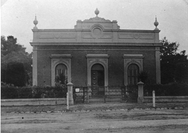
 Stawell Historical Society Inc
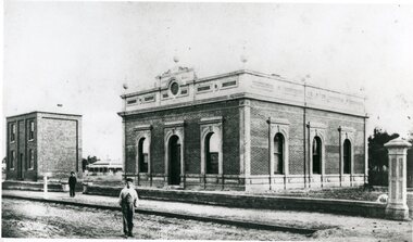
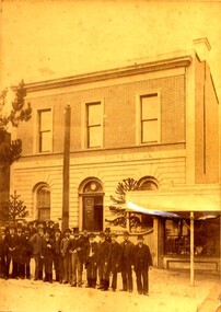
Photograph, Stawell Shire Hall 1866
This photograph is a copy obtained from State Library of Victoria. The photograph is of Stawell Shire Hall. Two persons can be seen in the foreground. The two story brick building beside the Stawell Shire Hall was once the Literary Institute. The Stawell Shire Hall building has been added to over the years. Ronald Campbell, the Shires second president laid the foundation stone on 28th April. 1866. The contractors were Hutchings and Delbridge. The photograph shows the first hall and office. The building contained simple 18 feet square rooms, with an entrance hall separating them, the facade was almost as it is now. The initial cost of the Shire Hall was $502.Black and white photograph of Stawell Shire Hall as one single storey brick building with parapet on top. Beside the Shire Hall is a two storey brick building. Also, a dwelling between the two building in the background in Cooper St. Two persons in the foreground, one on the road the other on the pathway. stawell -
 Rutherglen Historical Society
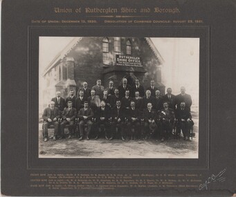
Image, Alf L. Bowden, The Studio, Union of Rutherglen Shire and Borough, 1920 (Exact)
Copy of a photograph of Wesleyan Church used as temporary Shire Office during building of new office. Group portrait of Councillors in front of building."Union of Rutherglen Shire and Borough / Date of Union: December 15, 1920. Dissolution of Combined Councils: August 25, 1921. Rutherglen Shire Office. The Secretary Attends Monday & Friday 10am till 4pm" Front row (left to right) Ex. Cr. S.P. Gollings, Cr. R. Ready, Cr. E.E. Cock, Cr. J. Burch (Ex Mayor), Cr. C.H. Morris (Shire President), J. Hiskins (Ex President), Cr. R.J. Burrowes, Cr. D.B. Smith, Cr. P. Gullifer / Centre Row (left to right) Cr. H.G. Richards, Cr. W.H. Chambers, Cr. R.H. Berryman, Cr. R.J. Harvie, Cr. W.R. McRae, Cr. W.V. McDonald, Cr. C.L. Dobbin, Cr. R.A. McLaurin, Cr. P.M. Seymour, Cr. M.T. Graham, Cr. F. Fuge, Cr J. Milthorpe / Back Row (left to right) T. Trenen (Editor "Sun"), P. Lingford (Shire Engineer), W.C. Bayliss (Banker), A.H. Thompson (Shire Secretary, A.C. Carter (Inspector), N.F. Turnbull (Assistant Secretary)" -
 Melton City Libraries
Photograph, Melton Shire Councillors, 1924
J.T Minns was president of the Shire Council from 1923-24 Isaac Robinson was president of the Shire Council from 1924-25. The Robinson family lived in the area. The following is from 100 Years at Melton: Isaac and Henrietta Robinson. Jeanette nee Rohner Robinson 1985. Creighton Melton. The Robinsons of Wyndham William Robinson married Ann Bee in 1952, Weardale, Durham England. They arrived in Australia on the ship “Ben Nevis” in 1852. They settled in Wyndham in 1855 and began dairying and haygrowing. They bought 50 acres and rented 300 acres until buying 300 acres in 1872 – Mt Pleasant Farm. Their children were sent to school even though Ann had been a school teacher in England. The older boys had to travel 5 ½ miles to Mt Cotterell school before one was built at Tarneit, a mile from their home. The children of William and Ann: George, Thomas, William, Isaac, Mary Ann, Mary Ann , John and Thomas. Thomas moved to Melton aged 19. When Ann died in 1898 Mt Pleasant farm was let then sold about 1920. In 1872 William Snr bought more land in Melton. William, Isaac and George worked on the land until 1887 when George and Isaac bought more land in Melton Creighton. Thomas and John also bought adjoining land. Outside Shire Offices, High Streetcouncil, local identities -
 Stawell Historical Society Inc
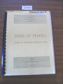
Book, Tom Hutchison & Denise Thorson, Shire of Stawell - Study of Selected Heritage Sites, 1994
This report is a re-evaluation of the Historical Survey: Shire of Stawell as undertaken by the Stawell and Halls Gap Historical Societies in June 1990.Yellow Card cover with black print and black plastic bindingFinal Document Prepared for the Shire of Stawell and Heritage Victoria Shire of Stawell Study of Selected Heritage Sites Prepared by Tom Hutchison and Denise Thornson November 1994stawell heritage -
 Linton and District Historical Society Inc
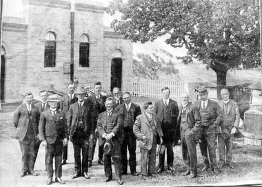
Photograph, Grenville Shire councillors outside first Council offices at Linton, c.1875
The Shire of Grenville was proclaimed in 1864. The Shire offices and hall are believed to have been completed by the mid 1860s.Original sepia photograph showing a group of men standing outside the Shire Council offices at Linton. Photo shows the fence at the front of the Grenville Shire offices, and part of the next-door shop (Austin's at that time?). This photograph is also Mounted photo 4 and Mounted photo 427. Original photograph and Mounted photograph 4 both have some names of Councillors handwritten on the back.shire of grenville offices, grenville shire hall, buildings, councillors, austin's shop, william brown, joseph shepherd, alex mcvitty, james dodds [shire secretary], john clarke, w. g. bennett, mr preston -
 Orbost & District Historical Society
cash book, 1960
This ledger was used by the Shire of Orbost from 1960-1962. The item was donated to Orbost & District Historical society from P.R.O.V. as a Place of Deposit (POD) item for safe keeping by a local history group or museum. The shire covered an area of 9,347 square kilometres and existed from 1892 until 1994 when it became part of the East Gippsland Shire Council. Orbost was at first included in the Bairnsdale Shire from 1882 and was later part of the Tambo Shire. Because of travelling distances the Croajingalong Shire was created in 1892 (name changed to Orbost Shire 17.2.1893 with James Cameron as the first Shire President. In 1994 it amalgamated to become part of East Gippsland Shire Council This is a handwritten record of accounts for the Shire of Orbost Council. It vpredates computer records. The Shire of Orbost no longer exists having been absorbed by the East Gippsland Shire Council.A heavy cash book with wooden covers and metal hinges. It is lockable and contains handwritten records of accounts. Emu Binding.On front cover - East Gippsland Shire council logo label with "ORBOST" handwritten in black. -
 Learmonth and District Historical Society Inc.
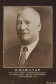
Photo - Ryan.M.J, Thornton Richards & Co, M.J.Ryan,(J.P.) Councilor/Shire President, "Circa 1950"
Councilor M.J.Ryan,(J.P.),was first elected as a member of the Ballarat Shire Council on the 30th. August 1897, serving until 1915. He was then re-elected in 1918 and served until1953. He was appointed Shire President in 1902-08-14-23-32-38-44-50.Original Historic photo.Sepia Photo of Councilor M.J.Ryan,(J.P.),set in a dark Brown plain wooden frame with gold trim on inside of frame.photo surounded by dark brown mount. Councilor M.J.Ryan (J.P.). First elected a member of the Ballarat Shire Council on 30th August 1897.Appointed Shire President 1902-08-14-23-32-38-44-50.ballarat shire council, ryan m j j p, 1897 1950 -
Clunes Museum
Photograph - POSTCARD, PHOTOGRAPHER - ALEX GILLESPIE
COLOURED POSTCARD OF THE CLAN CAMERON MUSEUM, ACHNACARRY SPEAN BRIDGE, INVERNESS-SHIRE, SCOTLANDlocal history, document, postcard, cameron of clunes -
 Learmonth and District Historical Society Inc.
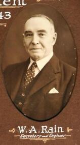
Photo - Rain W.A, Thornton Richards & Co, Rain WIlliam Alexander,Secreatary and Shire Engineer, 1942-43
Mr William.Alexander Rain was Secretary and Engineer for the Ballarat Shire Council for 1942-43.Original Historic Photo of Councilors 1942-43.Sepia photo, in brown mount,oval in shape, of Mr William Alexander Rain, Secretary and Engineer.Situated bottom row,second from right which forms part of collection of photos of all councilors and staff for 1942-43.Presented to Ballarat Shire Council by Councilor R.T.White,(J.P.),President 1942-43.1942, 43, rain, ballarat shire council, wa -
Clunes Museum
Document - REPORT, HEPBURN SHIRE, 2024
PLANNING POLICY PRINCIPLES WILL BE TAILORED TO RESPOND TO LANDSCAPE VARIATION AND DRIVERS OF LAND USE CHANGE AND THE DIFFERENTIAL IMPACT THAT THESE HAVE ACROSS THE SHIRE....1 RURAL HEPBURN - AGRICULTURAL LAND STUDY AND RURAL SETTLEMENT STRATEGY, UNBOUND REPORT PRINTED IN COLOUR ON PAPER, 94 PAGES .2 FUTURE HEPBURN - CLUNES STRUCTURE PLAN, UNBOUND REPORT PRINTED IN COLOUR ON PAPER, 67 PAGES ADOPTED BY HEPBURN SHIRE COUNCIL 3 SEPTEMBER 2024hepburn shire council, rural settlement strategy -
 Tatura Irrigation & Wartime Camps Museum
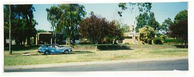
Photograph, Shire Office and Library, Casey Street, Tatura
Shows picture of the former Shire office and Library in Casey Street, Tatura. Colour photograph showing former Shire Office and Library in Casey Street, Tatura. Photograph stuck onto piece of white cardboard. shire office tatura, tatura library, casey street tatura -
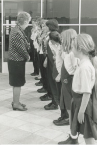
 Lakes Entrance Historical Society
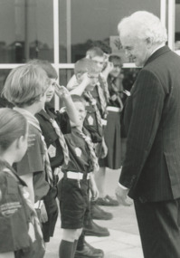
Photograph - Guides and Scouts outside Shire Office Lakes Entrance Victoria, Lakes Post Newspaper, 1/10/1996 12:00:00 AM
Governor Richard McGarvey inspecting Guides and Scouts outside Shire Office Lakes Entrance Victoria. Black and white photograph of Governor Richard McGarvey inspecting Guides and Scouts outside Shire Office Lakes Entrance Victoria. scouts, clubs -
 Bendigo Military Museum
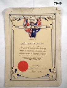
Certificate - SHIRE OF MCIVOR, Shire of McIvor, 1941
Refer Cat No. 7944. Item in the collection of "Arthur E. Tranter", V50166 - VX52843 - 2/29th Bn POW.Certificate - cardboard, off white colour with red, blue and brown print. Illustrated with scroll design: outline map of Australia, with inscription "GOD, KING/ AND/ COUNTRY": Crossed flags on poles and banner with "Shire of McIvor". Lower left corner - embossed red colour seal adhered to certificate. Certificate presented by the Shire of McIvor - "In appreciation of your voluntary enlistment for active service overseas".Handwritten in black ink - "Lieut Arthur E. Tranter/ 30th May 41" Signed by "A.R. Hagan (President) D.R. Thomas (Councillor) ??? (Shire Secretary)certificates, ww2, arthur e tranter -
 Stawell Historical Society Inc
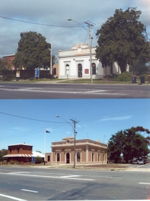
Photograph, Stawell Shire Hall -- Before and After colour photos of the Shire Hall, one photograph taken in 2011
Two Stawell Shire Hall colour photos showing the changes over time to the landscape around the Shire building. In 2011 the two Norfolk Island hibiscus trees were removed. In the photo with the trees removed the building is painted a brown colour and has the Australian flag flying on the flag post. Two colour photographs of Stawell Shire Hall showing how the landscape around the building has changed over time. In 2011 the Norfolk Island Hibiscus trees were removed. The building was painted white in one photo and when the trees removed painted a brown colour similar to the initial brick of the building. stawell -
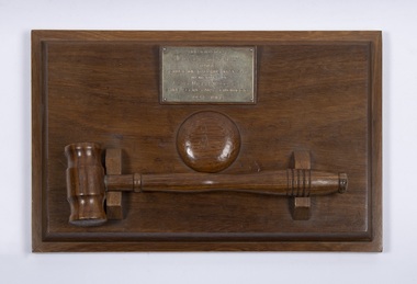 Bacchus Marsh & District Historical Society
Ceremonial object, Presentation Gavel and Sound Block presented to Shire of Bacchus Marsh in Memory of Alec William Bond, 1968
Alec William Bond was Secretary and Engineer for the Shire of Bacchus Marsh from 1924 until his death in 1968. The position of Secretary was similar to a Chief Executive Officer in contemporary terminology. Mr Bond was a prominent figure in the Bacchus Marsh community for nearly 50 years and as Shire Engineer was responsible for the design of a number of local infrastructure projects including the buildings and water scheme at the Lady Northcote Children's Farm at Glenmore and the public swimming pool in Grant Street, A physical memento that recognises the long and notable contributions of an important local government official and their service to the Bacchus Marsh Shire and community.A sound block with a green felt base and inscribed brass plaque with accompanying small hardwood mallet in a cradle.Engraved text on a brass plaque which reads: Presented by May Bond and Family to the Shire of Bacchus Marsh in memory of Alec William Bond Shire Secretary & Engineer 1924 – 1968.alec william bond, bacchus marsh shire council, gavel and sound blocks, local officials and employees, local government -
 Stawell Historical Society Inc
Photograph, Stawell Shire Hall 1866 - c 1890
Stawell Shire Hall built 1866, photo taken around c 1890s. The Shire Hall has a decorative gate and fence in front of the building. This photo is an enlargement of the post card in album 14, p26. Black & white enlarge photograph of the Stawell Shire Hall c 1890's. This photo is taken from the original post card in Album 14 page 26. The post card has an EMPIRE symbol on the back with a lion and kangaroo between them is a camera on a stand. The photo shows the Stawell Shire Hall with a decorative fence in front of the building and hedge behind the fence.Post Card with EMPIRE symbol on the back.stawell -
 Lakes Entrance Historical Society
Photograph - Brownies at Shire Office Lakes Entrance Victoria, Lakes Post Newspaper, 1/10/1996 12:00:00 AM
Mrs McGarvey wife of Governor Richard McGarvey inspecting the Brownies at Shire Office Lakes Entrance VictoriaBlack and white photograph of Mrs McGarvey wife of Governor Richard McGarvey inspecting the Brownies at Shire Office Lakes Entrance Victoriaguide group, scouts, clubs -
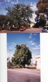 Stawell Historical Society Inc
Photograph, Stawell Shire Hall -- 1 Photo 1999 & 2 Photos 2011 -- Coloured
Three photos of trees around Stawell Shire Hall, one photo taken in 1999 and two coloured taken 2011. Two are of the Norfolk Hibiscus, one 1999 and the other 2011 when the tree was removed. The other coloured photo is of the English Oak on the right side of the Shire Hall taken in 2011.Three photos of trees around the Stawell Shire Hall, two taken in 2011 & one in 1999. The 1999 photo is black & white and of the garden bed on the right of the Stawell Shire Hall. The other two photos taken in 2011 are of two different trees. One on the left side the Norfolk Island hibiscus tree removed in 2011 and on the right an English Oak tree.stawell -
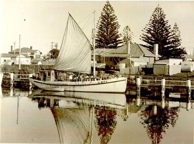 Port Fairy Historical Society Museum and Archives
Photograph
The Inverness was a well boat built in Port Fairy 1938 by K.N. Lacco and Sons for Johnny McDonald who owned and operated her until about 1942 when she was taken by the armed forces. In 1946 after the 1939-1945 War she was bought in Sydney by Tommy Davis, Jim 'Jumbo' Terjeson and Peter 'Runt' Terjeson. RFB 233 on the register 1938-1942 and 1946 - c1963Well known boat built in Port Fairy for Johnny McDonald taken for use by the armed forces in 1942 she was found in Sydney and bought by Tommy Davis , Jim Terjesen and Peter Terjesen and returned to Port FairyBlack and white photograph of Fishing boat ‘Inverness’ with sail furled berthed at lower end of wharfwell boat, peter runt terjesen, tommy davis, johnny mcdonald, jim jumbo terjesen, inverness, rfb 233, k.n.lacco, peter terjeson, tyson, runt -
Lakes Entrance Historical Society
Book, Voters Roll for the Bumbererrah Riding of the Shire of Tambo 1990-1991, 1990
Alphabetical list of Voters in the Nungurner, Kalimna West, Metung areas, Bumberrah Riding, Shire of Tambo, Victoria, giving names and addressesAlphabetical list of Voters in the Nungurner, Kalimna West, Metung areas, Bumberrah Riding, Shire of Tambo, Victoria, giving names and addresseselectoral rolls, directories -
 Stawell Historical Society Inc
Photograph, Stawell Shire Hall -- Before and After trees were removed 2011 -- 3 Photos -- Coloured
Three photos showing Stawell Shire Hall after trees removed in 2011. The building is painted a brown colour and in all 3 photos the Australian flag is flying on the flag post out the front. The three photos show different views of the building. One of the photos on page 29 Album 14 shows a deciduous tree also planted on the right side of the building. Three colour photos of Stawell Shire Hall taken in 2011 showing the building without the Norfolk Island Hibiscus trees. The Shire Hall is painted a brown colour and show the brick veneer addition on the left. The three photos are in Album 14 pages 26 & 29 showing the new deciduous tree planted out the front and the brick veneer addition on the left of the Shire Hall. stawell -
 Federation University Historical Collection
Booklet, John Fraser & Son, Shire of Buninyong, 1858-1958, 1958
Booklet of loose pages held together with yellow ribbon. Photographs of Buninyong.non-fictioncentenary, fisken, shire council, district road board, buninyong, 1958, dallas brookes, governor of victoria, archibald fisken -
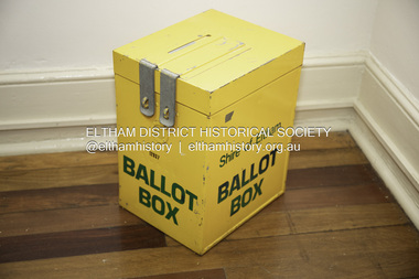 Eltham District Historical Society Inc
Decorative object (Item) - Steel Box, Shire of Eltham Ballot Box
These boxes were used at various polling booths throughout the Shire of Eltham for voters to place their completed votes in during council elections. On occassions EDHS has used this Ballot Box as a repository for cash donations at meetings and functions."Ballot Box" and "Shire of Eltham Ballot Box" and a serial number "12937".eltham shire council, shire of eltham archives, ballot box, elections, shire of eltham, activities, donation, council elections -
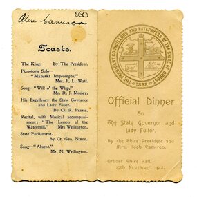 Orbost & District Historical Society
menu, 1912
This item is an invitation to a dinner given by the Shire President and Mrs Hugh Cameron for the State Governor and Lady Fuller to be held in the Orbost Shire Hall on November 19, 1912. The governor and his wife left Melbourne on November 14 on a visit to East Gippsland. Hugh Cameron (1850-1921) was on the Orbost Shire council from 1892-1915. (more info. in O.D.H.S. newsletter -Tambo Shire) The Shire of Orbost was a local government area about 380 kilometres east of Melbourne, the state capital of Victoria, Australia. The shire covered an area of 9,347 square kilometres (3,608.9 sq mi), and existed from 1892 until 1994. Originally, Orbost was part of the Bairnsdale Road District which was created on 30 April 1867. Splitting away as part of the Shire of Tambo in 1882, Orbost was first incorporated as a shire in its own right as the Shire of Croajingolong on 30 May 1892. It received its present name on 17 February 1893. On 3 January 1913 part of its western riding was annexed to Tambo as its Cunninghame Riding. On 2 December 1994, the Shire was abolished, and merged with City and Shire of Bairnsdale, Shire of Tambo, most of Shire of Omeo and the Boole Boole Peninsula from Shire of Rosedale into the Shire of East Gippsland. This item is associated with Orbost Shire Council which no longer exists. It is also associated with Hugh Cameron.A small menu on a cream folded card with blue print. On the front is stamped a large blue logo of the Shire of Orbost. The text is "Official Dinner". On the back is a list of toasts and inside is the menu.On back - handwritten - "Alex Cameron"orbost-shire-council cameron-hugh