Showing 481 items matching "john downing"
-
 Mt Dandenong & District Historical Society Inc.
Photograph, Looking Down Falls Road
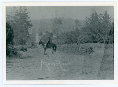
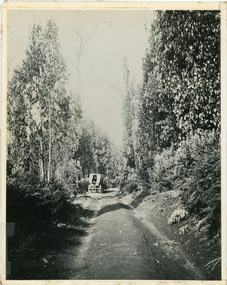
... 1914, shows Edward John Price on his pony delivering papers ...Edward John Price was a son of early settler Edward Joseph Price. Edward Joseph was the first settler in the Village Settlement when he took out Lot 1, Section 1. He built a small home of slabs and brought his family up in 1896. From the outset the Price family ran a store from their home.This picture, taken 1914, shows Edward John Price on his pony delivering papers from his parent's newsagency that was opposite 'Mountjoy' guesthouse on Ridge Road. He was taking them to Lily Badenhop's post office in Blythe's Road. The section of road he is on was called Main Road and is now Falls Road.Black and white photograph showing a man on horseback in the centre of an unmade road that is running into the distance.Trees, a fence and houses can be seen with hills in the background. Reverse of photograph has handwritten description by John Lundy-Clarke.On Front MAIN ROAD On Reverse Looking down Falls Road then the main road in 1914. Before Frank Craig built The Fron (1918). Dunbar’s house Halcyon on left of road. The hall on its right with Keogh’s sheds showing further in the trees. The horseman is Edward John Price who delivered the daily papers to Lil Badenhop’s shop. The bag he carried them in can be seen hanging from the saddle pommel. The first road formation can be seen on the bank to the right. The road seen was constructed 1905 by Bill McGivern.edward john price, edward joseph price, lily badenhop, post office, falls road, main road, mountjoy, frank craig, bill mcgivern, dunbar, halcyon, keogh, farndons hall -
 Mt Dandenong & District Historical Society Inc.
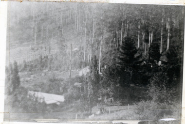
Photograph, Harmony Vale 1933
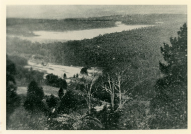
John Lundy-Clarke grew up in the Kalorama/Mt Dandenong area and later in life (1972-74) began to write a comprehensive history of the area working from an original settlement map in an effort to cover all areas. Harmony Vale was the name of the homestead built by early pioneer Jabez Richardson. The whole of the valley took on this name. The building lasted until 1933. The Silvan Dam was completed in 1932 and was full when this photograph was taken.Black and white photograph looking down over a forested area with a dam in the background. Copied from a Rose Series postcard c1933. Handwritten inscription on reverse by John Lundy-ClarkeRose Series photo of 1933 showing “Harmony Vale” still standing. Copied 1973 JLCharmony vale, silvan dam, jabez richardson -
 Mt Dandenong & District Historical Society Inc.
Photograph, View From Corner of Doughty's Road and Barbers Road 1913
John Lundy-Clarke grew up in the Kalorama/Mt Dandenong area and later in life (1972-74) began to write a comprehensive history of the area working from an original settlement map in an effort to cover all areas. Taken c1913, this photograph gives a clear indication of where significant buildings were located in relation to one another. Barbers Road is running through the picture with the guest house 'Kia-Ora' , built by George Barber in the centre. High on the skyline on the left is the 'Mountjoy' guesthouse, indicating the location of The Gap, or FiveWays. The small 'boxy' house above 'Kia-Ora' is 'Iona' built by the Paynter family who also built 'Mountjoy'. The Jeeves property 'Kalorama' is to the right of 'Iona' and this is the area you now look to from the FiveWays Lookout. The man in the photo is wearing a trilby hat so is probably a Rose Series employee - a feature in many Rose Series postcards.Black and white photograph that is a copy of Rose Series Postcard # 156. A man can be seen walking down an unmade road with haystacks to his right. Buildings and crops can be seen on the hillsides. Handwritten inscription on reverse by John Lundy-ClarkeView from corner of Doughty’s and Barbers Road 1913. “Kia Ora” in centre Paynter’s “Iona” near center skyline above “Kia Ora” with “Kalorama” on its right and Peter’s hut of the time below it among orchard trees. “Mountjoy” is on left skyline. W. Haye’s home is centre left. Hay paddock is Barbers Lot 25 Village Settlement.kia-ora, iona, kalorama, mountjoy, guesthouse, guest house, barbers road, doughty's road, paynter, jeeves, george barber -
 Mt Dandenong & District Historical Society Inc.
Photograph
Jim Keogh owned Lot 7 of the Village Settlement. When the new CRB road went through c1920 his block was cut through leaving a small triangle of land on the high side of the CRB road. He built a shop on this piece of land. The store burned down 31/12/1939. The woman on the step in this photo is Win Woodcock.Sepia image of a woman standing in front of a wooden store. Handwritten inscription on reverse by John Lundy-ClarkeJim Keogh's shop on the north west corner of Falls and Main Roads. Opposite diagonally from St Michael's Church of England. photo Nov 1926.jim keogh, keogh, store, shop, crb road, win woodcock -
 Mt Dandenong & District Historical Society Inc.
Photograph
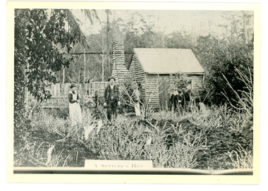
... as an office by the road builders. It burned down that year. Keogh John ...The Keoghs took up Lot 7 in the Village Settlement in 1905. John Keogh was a big Irishman and cleared many of the giant trees on his Lot 7. They had little water for their crops so grew gooseberries and red currants rather than the more valuable strawberries. Mrs Keogh (nee Cleary) inherited money in 1906 and they built a new weatherboard house. The original bush hut remained as the kitchen. Son James (Jimmie) married Mary Walsh, a teacher at the local school. Jimmie built the small shop on the triangle of land cut off when the CRB road went through. Jimmie and his wife left the district when he joined Victoria Police. Jimmie came back to the area and finally sold the land of Lot 7 to Rimington's Nurseries. He moved his family to Kilsyth. In 1939 the shop was moved across the road to be used as an office by the road builders. It burned down that year.Black and white photograph of a man, woman and young male standing outside a wooden hut. There are crop remnants in the foreground and a wooden paling fence behind the hut. A label on the front reads A SETTLER'S HUT. Reverse of photograph has handwritten description by John Lundy-Clarke.Front: A SETTLER'S HUT Reverse: 1905 Keogh's hut on Falls Road then Main Road. This was later the kitchen of their extended home as described in the narrative "Mountain of Struggle". The figures are - Mrs Keogh. John Keogh settler. Son James Keogh.keogh, john keogh, james keogh, jimmie keogh, mary walsh, cleary, shop, store, gooseberries, rimington's nursery -
 Mt Dandenong & District Historical Society Inc.
Photograph, Main Street Olinda c1908
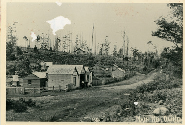
c1908 view of Main Street Olinda with Dodd's store in foreground and Olinda State School up on the hill. Reverse of photograph has handwritten description by John Lundy-Clarke.Photo of Olinda taken about 1908 showing State School on skyline. Dodd’s store in foreground. Hodges blacksmith shop on roadside right. Coonara Road, then Mernda Road leads up out the picture right, Mt Dandenong Road goes down left. Range Road (the bullock track) is in immediate foreground and Sassafras turns to the right before the visible tracks on Mernda Road.olinda, jack dodd, general store, school -
 Mt Dandenong & District Historical Society Inc.
Photograph, 'Hillcrest' on Mernda Road, Olinda 1911, 1911
Front view of 'Hillcrest' the Devine family home on Mernda Road, Olinda taken in 1911. The road deviation passed to the right of where the photographer was standing. The descriptive text on the reverse of this photograph was hand written by John Lundy-Clarke.“Hillcrest” the home of the Devine family 1911 in Mernda Road now Coonara Road. The road was deviated here to regrade it and the deviation past to the right of the camera. The house fronted down over the valley of the Sassafras Creek towards Kallista. It was close to the spot where the camera stood that the girls practiced the maypole dance in 1911. Vera Devine trained 11 of her mates in the dance here.hillcrest, mernda road, olinda, vera devine, devine family -
 Mt Dandenong & District Historical Society Inc.
Photograph, c1911
"Hillcrest" on Mernda Road, Olinda. The home of the Devine Family. c1911 The descriptive text on the reverse of this photograph was hand written by John Lundy-Clarke.“Hillcrest” Mernda Road Olinda 1911. The home of the Devine family. The early settlement road passed to the left of the camera. House faced down over the valley of the Sassafras + Perrin Creek towards Kallista. The deviation to regrade the road passed to the right of the house. It was in front of the house on the left hand side of the picture that Vera Devine and her school mates practiced the maypole dance under her tuition. hillcrest, devine, devine family, mernda road -
 Mt Dandenong & District Historical Society Inc.
Photograph, Jeeves Coach on CRB Road at Foot of Farringdon Road Kalorama, 1920, 1920
Scene looking down Farringdon Road showing Jeeves horse drawn coach going along the CRB road (Mt Dandenong Tourist Road) in 1920. Detailed inscription on the back handwritten by John Lundy-Clarke in 1974.Jeeves Coach on CRB road at foot of Farringdon Road Kalorama (Mt Dandenong North) 1920. Road was formed most of the length from Montrose by contractors Bladin and Dick employing Robert Logan the younger, in 1919 and lay unmetalled till metalled by the contractors in 1922. Mountain ash trees in foreground were on Thomas Hand’s original 23 acre holding. Those beyond coach were on Isaac Jeeves original 160 acre holding Selection Crown Allotment 925(B). This was the area forming part of the inheritance lost by John William Richardson because of the expense of his wife’s illness. Hand enlarged his 23 acres to 305 in 1874. William and his family grew large crops of raspberries on his area, part of which is in the foreground. It had been cleared by his father’s employees before 1877. The section below the Main Road was cultivated by Fred hand, son of William and grandson of Thomas in the twenties before he moved to Redcliffes where he is today (1974). Comment by John Lundy-Clarke 10.5.1974 coach service, jeeves, crb road, farringdon road, kalorama, mt dandenong north, mt dandenong tourist road, john lundy-clarke, coach -
 Mt Dandenong & District Historical Society Inc.
Photograph, Kalorama Gap Under Snow 1921, 1921
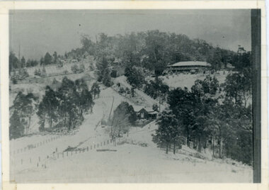
View of Kalorama Gap under snow taken in 1921. Mountjoy Guest House is at top right and Beulah Tea Rooms is in the centre. This photograph has a detailed inscription on the back handwritten by John Lundy-Clarke in 1974.Kalorama Gap under snow 1921 The leafless elm trees are low in the centre and the dual nature of the nearer one can be clearly seen, two small suckers of the older farther tree being twisted together in 1898 by Fred Jeeves. The older tree was planted 1880. Mrs Hands shop can be clearly seen, which was the Mount Dandenong North Post Office. The old Main Road runs up the centre of the picture and turns to the right and disappears behind “Mountjoy” the big guest house built by Paynters in 1905 and sold to Ellis Jeeves 1908, whose family ran it till 1943. At the bend of the road behind the big pine tree and the dark blackwood can be seen faintly the gable of Price’s house that contained the first shop on the mount. Above it is H Walker’s cottage on Ridge Road that still exists, his homestead is on the left of the picture on the same level. Below this house and to the left can be seen Ted Prices hay and corn store. The present estate agency lies between these two buildings, on the road which had recently been built. This can be seen winding from the lower left corner of picture to the left of the elms. The CRB had recently fenced the road and this is clearly seen as it circles behind trees in the left centre. Barber’s Road crosses CRB Road to the left of the dray under the leafless elm and the Coach Road dives down to the right just behind the pair of blackwoods to right of the elms. The picture was taken from just above the boundary of Isaac Jeeves’s selection Crown Allotment “C” (Jeeves Saddle) which stretched across the Gap to the other side of Mrs Hand’s shop, monopolising the gap from 1871 to 1879. Price’s house remains partly as the small house – “Mirra Laken”. kalorama gap, fiveways, post office, mountjoy, guest house, snow -
 Mt Dandenong & District Historical Society Inc.
Photograph, Isaac Jeeves First Home On Running Creek 1917, 1917
Enlargement of photograph taken by Norman Rowse in 1917 that shows the first home of Isaac Jeeves built at the Running (Olinda) Creek. This photograph has a detailed inscription on the back handwritten by John Lundy-Clarke in 1974.Enlargement of photo taken by Norman Rowse in 1917 of the group of buildings erected as his first home by Isaac Jeeves at the 800° contour on the Running (Olinda) Creek on Crown Allotment 925A. The small building on the right behind the pony and the fowls was Isaac’s first substantial home and was occupied in 1858 he having lived in camp on the creek as a miner since 1855. The tall building on left was barn built in the sixties and the large roof behind was the five roomed house with a tree fern floor. This last building was of blackwood entirely above the floor and was built in the early sixties. The two old homes were pulled down by the Rowses in 1918 and the tree fern floor was pulled up by Len Childs in 1933.norman rowse, isaac jeeves, len childs, running creek -
 Mt Dandenong & District Historical Society Inc.
Photograph, Post Office and 'Mountjoy', Mt. Dandenong North, 1913
Rose Series post card #182Copy of Rose Series postcard #182 showing Kalorama Gap in 1913. Haystacks in foreground with Mountjoy Guest House and Beulah Tea Rooms/Mt Dandenong North Post Office in centre. This photograph has a detailed inscription on the back handwritten by John Lundy-Clarke in 1974.Kalorama Gap in 1913 The elm trees are in the centre of the picture. One of these is really two as two suckers of the further tree were twisted together by Fred Jeeves in 1898 and grew as one tree. The other was planted in 1880. The shop is the shop of Mrs Eliza Hand and daughter Florence. The closed in far end of the verandah was the Mount Dandenong North Post Office. The large house is “Mountjoy” owned and run by the Jeeves Family from 1908 till 1943. It was built in 1905 by the Paynters who sold to Ellis Jeeves in 1908.He moved his line of coaches from “Kalorama” his old homestead and housed the horses in a line of stables behind “Mountjoy”. Price’s house, which contained their shop, the first one on the mountain, opened 1906, can be seen faintly behind the pine tree opposite the bend in the road, which was the main road then and now is Ridge Road. The Price’s house just shows in two tiny pieces, one on each side of the pine tree half way up. The house to the right of and high up the pine tree is Walker’s cottage which exists today opposite Jack Kidd’s home at the far edge of Lt 2 Village Settlement and was between Main Road and Barbers Road which runs down the left behind the elms. Walker’s homestead can be seen near left edge of picture 2/3 way up. The roof of the Methodist Church shows among trees left of picture. This, like Mrs Hand’s shop was built on portions separated from Isaac Jeeves’ Selection “C” known as Jeeves Saddle. kalorama gap, five ways, mountjoy, john lundy-clarke, beulah tea rooms, post office, fred jeeves, paynter, jeeves, frederick jeeves, price, walker, jack kidd -
 Mt Dandenong & District Historical Society Inc.
Photograph, Harry Walker's Home in Village Settlement 1908, c1908
View of Harry Walker's home taken from waht is now known as Ridge Road, Kalorama. Raspberry crops are in the foreground. This photograph has a detailed inscription on the back handwritten by John Lundy-Clarke in 1974.1908 view of H Walker’s home on Village Settle Lot 2 Section 1. Looking from what is now Ridge Road through the trees on Vil. Set Lot 18 to Barber’s house now known as “Forest Edge” on Vil Set Lot 25 down close to the Olinda Creek on Barbers Road. The Estate Agent’s modern office is on the edge of the patch of raspberries at the lower left as the C.R.B. Mt Dandenong Rd passes just behind Walker’s house crossing the picture behind the raspberries.walker, raspberry crop, forest edge, barber -
 Mt Dandenong & District Historical Society Inc.
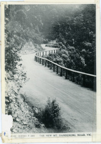
Photograph, The New Mt Dandenong Road, Vic
Copy of Rose Series postcard #385 showing the new Mt Dandenong Tourist Road with wooden railing fence on low side of road. Surface not yet made. This photograph has a detailed inscription on the back handwritten by John Lundy-Clarke in 1974.View downhill from the Windy Bend showing the site of the 1972 landslide. In this picture the road is running along the top edge of the wall 900’ thick of Kalorama Docite that plunges thousands of feet deep down into the earth below the Ranges and extends to Fern Tree Gully. It was once a horizontal terrace nearly ten miles square and tipped over to the left when the mountain subsided into its volcanic cauldron.mt dandenong road, rose series, windy bend, landslide -
 Mt Dandenong & District Historical Society Inc.
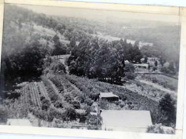
Photograph, View of valley looking south over 'Kalorama' towards falls, 1908
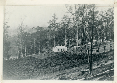
View taken 1908 looking south over 'Kalorama', home of Ellis and Eliza Jeeves, across the valley towards the falls.This photograph has a detailed inscription on the back handwritten by John Lundy-Clarke in 1974.View taken 1908 of valley looking south over “Kalorama” towards the falls. House right of “Kalorama” was Paynter’s “Iona” on Lot 29. Faintly below line of Barber’s Road above “Kalorama” is Logan’s house on Lot 28. House against orchard was Pimm’s later Prince’s Lot 19. Big trees on right were on Price’s Lot 18 and were between Tosari Rd and Rosemont Cres. It was FROM one of these being cut up in 1931 that the round length log weighing ½ a ton got away from the splitters and raced down the hill in bounces, one of which cleared Barber’s Rd and Logan’s house in leaping from the fence line above the road.kalorama, paynter, iona, barbers road, ellis jeeves -
 Mt Dandenong & District Historical Society Inc.
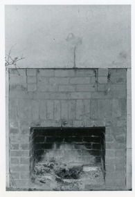
Photograph, Open Fire Place in Worker's Cottage, 1972
Photograph taken in 1972 showing an open fire place built of recycled brick in a worker's cottage. This photograph has a detailed inscription on the back handwritten by John Lundy-Clarke in 1974.Open fire place in workers cottage built of bricks from house built for John William Richardson 1897. Chimney built for Rowses by J. Lundy-Clarke May 1938. Picture taken 18-11-72 Richardsons house was pulled down by Rowse Bros. 1937-8. fireplace, richardson, rowse, john lundy-clarke -
 Mt Dandenong & District Historical Society Inc.
Photograph, 1913 View Over Logan's House in Village Settlement, 1913
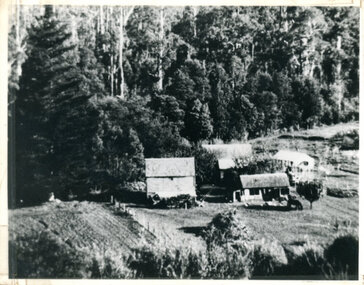
Photograph taken in 1913 from Barbers Road showing the view down the valley. Roof in foreground is house on Bob Logan's Lot 28 in the Village Settlement. This photograph has a detailed inscription on the back handwritten by John Lundy-Clarke in 1974.1913 view over Logan’s house on Village Settlement Lot 28 taken from Barber’s Road. This is the house that the runaway log leaped over in 1930 to land far down the orchard row beyond the house. “Shiloah” is centre partly behind the clump of trees and the paddocks of Child and Richardsons pioneer selections are in the background. Link Road is centre right.logan, bob logan, robert logan, barbers road, shiloah, child, richardson, link road -
 Mt Dandenong & District Historical Society Inc.
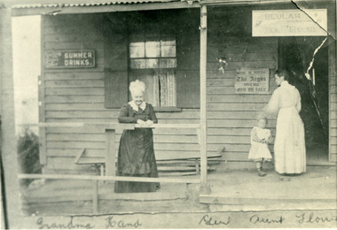
Photograph, Eliza Hand on the Verandah of her Shop 1907, 1907
1907 photoghraph of Eliza Hand (Grandma Hand), Florence Hand (Aunt Florrie) and little Gert on the verandah of the Beulah Tea Rooms at FiveWays (The Gap). This photograph has a detailed inscription on the back handwritten by John Lundy-Clarke in 1974.1907. Eliza Hand on the verandah of her shop at Kalorama gap with her daughter Florence. Opened as "Beulah Tearooms" it was made a post office in 1909 and Florence Hand became post mistress. It remained active till 1923 when, the building having been sold to Miss McPhee she built the Fiveways store alongside and moved the post office to another room. The verandah was pulled down but the room is still there (1974) facing Ridge Road at the west end of the complex. Eliza died 1918. Florence died 1968.beulah tea rooms, fiveways, the gap, florence hand, eliza hand, miss mcphee, post office -
 Southern Sherbrooke Historical Society Inc.
Information folder - Helen Gibson
Material formed part of estate of Helen Gibson and was acquired by the society.A4 folder containing documents pertaining to Helen Gibson. Contents: -letter of reference for Helen Gibson, handwritten, from William L. McSpeddon, Vicar, Drouin, Victoria, "To whom it may concern", dated 16th March 1944, A4 sheet folded in half -letter of reference for Helen Gibson, typed, from Ethel O. Matthews, ex-Sister-in-charge of [Infant Welfare] Centres in Dandenong Shire, "To whom it may concern", dated February 1952, 20.5 x 25.5 cms -letter of reference for Helen Gibson, handwritten, from A. Corcoran (?) Cleveland, Sister-in-charge, Port Melbourne Baby Health Centre, "To whom it may concern", dated 16th Aug 1946,16.5 x 19.5 cms -letter of reference for Helen Gibson, handwritten, from A. M. Adams, Sub-head, Correspondence School, Blackfriars, Sydney, dated 14th July 1931, 20 x 25 cms -Certificate of Competency as a Pre-School Play Leader, Department of Health, Victoria, No. 20, for Helen Alice Gibson, examiners Madeleine [illegible] & Gillian Henriques, signed N. Narbara Meredith & Helen W. Paul & [illegible], 27 x 21.5 cms -certificate, St John Ambulance Association, certifying that Helen Gibson has attended a course of instruction in home nursing. signed Arthur Sherwin, James Paterson, [illegible] Loomis, Enid Paterson, dated 25th Sep 1939, 23.5 x 17 cms -certificate, St John Ambulance Association, certifying that Helen Gibson has attended a course of instruction in rendering First Aid to the Injured, signed Rupert M. Downes, James Paterson, Henry Smith, Enid Paterson, dated 1st May 1939, 23.5 x 17 cms -letter of reference for Helen Gibson, typed, from Nobel Park Pre School Play Group, signed F. A. McGregor & F. B. Jenkins, undated but post-December 1951, 26.5 x 20.5 cms -letter of reference for Helen Gibson, typed, from Correspondence School, Blackfriars, Sydney, signed W. Finigan, dated 9th Feb 1032, 26.5 x 20.5 cms -letter of reference for Helen Gibson (labelled 'Copy" at head), typed, from Harry S. Needham, Archdeacon & Rector of Orange, NSW, dated 24th Feb 1932, 26.5 x 20.5 cms -letter of reference for Helen Gibson, typed, from G.W.S. Anderson, District Censor, Victoria Lines Of Communication Area, Melbourne, dated 26th July 1945, 21 x 18 cms -letter of reference for Helen Gibson, handwritten, from Enid Paterson, President, Garfield Country Women's Association, undated, 20.5 x 26.5 cms -letter of reference for Helen Gibson, typed, from W. Finigan, Headmaster, The Correspondence School, Blackfriars, Sydney, dated 16th Sep 1943, 20.5 x 26 cms (last three items held together with rusted pin) -also in back of folder is envelope containing the following items: -notebook, black, 16 x 10 cms, "Plots, Ideas, Bird Diary 1925" inside front cover, handwritten contents include story ideas and extracts copied from Joan Aiken's "The Way To Write For Children", extract from Wm. Temple's commentary on John's Gospel, a list of aboriginal names, and reminiscences by Miss Balmer -brown business-sized envelope with "References" written in pencil -brown A4 envelope with "Certificates P. L. St John Ambulance" written in ink and "Miss Helen A. Gibson" typed in blue ink, containing blue certificate stating that Helen Gibson has passed examinations and is entitled to receive the medallion, signed [illegible], General Secretary, dated 29th June 1942, 13 x 10 cms -cardboard certificate of baptism into the Church of God, for Ian Harold Gibson, born 13th May 1915, signed Edwin Dodd, St John, Nar-nar-goonhelen alice gibson, ian harold gibson, st john ambulance, pre-school centres, melbourne -
 Department of Health and Human Services
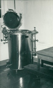
Photograph, Donated autoclave “If this only sterilizer (used only whenever all drums are filled to save electric power) breaks down, the hospital does not have sterile gauze or towels" - Equipment donated through Ziarah the Gull Force Association 2/21 Bn AIF / Dr John Forbes Fairfield Hospital & Caltex - Photo from Dr John Forbes photo albums - Ambon Hospital
Department of Health & Human Services - Dr John A Forbes Fairfield / Gull Force 2/21 Bn AIF / Ziarah Caltex & Rumah Sakit Ambon Hospital Indonesia CollectionDepartment of Health & Human Services - Dr John A Forbes Fairfield / Gull Force 2/21 Bn AIF / Ziarah Caltex & Rumah Sakit Ambon Hospital Indonesia Collection -
 Southern Sherbrooke Historical Society Inc.
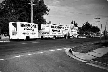
Photograph - Set of photos pertaining to Hermon's Removals, c. 1980s
Set of photos from c. 1980s pertaining to Hermon's Removals. William (Bill) Hermon Junior established a furniture removals business in 1935. Their depot was on the corner of Main Rd and Snodgrass St, Pakenham. When Bill's younger sons Ken and Ron, acquired the business in 1994 the business was renamed Hermon's Rainbow Removals, which remains in operation today. 1. Photograph of 3 trucks from Hermon's Removals on Main Road, Pakenham, down near McGregor Rd. Their depot was on the corner of Main Rd and Snodgrass St, Pakenham. 2. Photograph of one of Hermon's Removal trucks at Pakenham. 3. A photograph featuring three of Hermon's Removal Trucks lined up on a suburban street. 4. A photograph featuring Bill Hermon (second from the right of picture) and his sons, Ron, John and Ken. -
 Southern Sherbrooke Historical Society Inc.
Photograph - Glen Park Homestead, Percy and Cissy Johns on verandah, early 1900s
B&W photo shows siblings Percy and Cissie (Minnie Agnes) Johns on the verandah of their home, Glen Park Farm, Selby. Percy looks in his early teens, making the photo around 1910 or later. He is wearing a long-sleeved pale shirt, long dark trousers tucked into knee-high boots, and possibly a dark hat. Cissie is wearing a pale, knee-length dress, dark stockings, and a pale, wide-brimmed hat. She is aged about 10. A medium sized dark dog sits at Percy's feet. The house is an L-shaped weatherboard with two gables at right-angles and a verandah with a bullnosed roof, ornate support posts, and a striped end piece from the roof. Wooden steps lead down from side. There is a large brick chimney where the two wings meet, and a metal water tank to the side. There are large trees, both in leaf and dead, plus some flowers near the verandah. -
 Southern Sherbrooke Historical Society Inc.
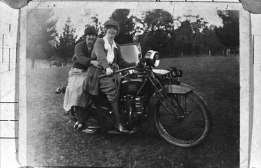
Photograph - Two women on a motorcycle
B&W photo shows Cissy Johns and friend on a motorbike at Glen Park Farm, Selby. The photo shows two women in their 20s or 30s, sitting on a motorbike with the registration number 12169. The woman on the right who is most likely Cissie, is sitting astride the bike, holding the handlebars. She is possibly wearing a peaked cap. She has a long knitted jacket over a pale blouse, and a medium coloured skirt which is rucked up by the bike's petrol tank, showing her right leg from the knee down. She has dark stockings and what appear to be medium-heeled, laced shoes with a high shine. The woman on the left is sitting sideways on the pillion seat, with her arms loosely around the first woman's waist. She is wearing a cloche-style hat, a dark knitted v-necked cardigan or jumper, a light-coloured, mid-calf-length skirt, dark stockings and dark shoes with large buckles. Her legs are crossed at the ankles. Both women are smiling at the camera. The windscreen of a sidecar is visible. They are in a cleared paddock with a wire fence and trees in the background. n.d. -
 Southern Sherbrooke Historical Society Inc.
Photograph - Percy Johns, 1930s
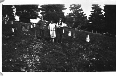
B&W photo of Percy Johns, an unknown woman and a farm worker during potato digging at Glen Park Farm, Selby, in the 1930s. Percy Johns stands on the left, wearing a dark hat, jacket with deep pockets, and pants. He is holding a shovel in his right hand, and his left hand is on his hip. Beside him is a young unidentified woman with dark hair, who is wearing a loose dress with a drop waist. Beside her is an unidentified farm worker, wearing a hat, dark waistcoat and pants, and pale shirt. He has a pipe in his mouth. They are standing between rows of potatoes. On the left of the photo there is a row with potatoes lying on the ground. There are at least eight full bags of potatoes in the field. Behind the trio is what appears to be the cypress avenue running down to the homestead out of range on the right of the photo. -
 Southern Sherbrooke Historical Society Inc.
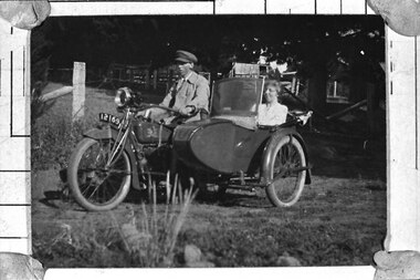
Photograph - Percy and Cissie Johns at Glen Park Farm
B&W photo of Percy and Cissie Johns at Glen Park Farm. Percy is astride a motorbike, reg # 12169, wearing a light coloured jacket over a shirt and tie, and wearing a peaked cap (similar to a uniform cap). Cissie is seated in the sidecar. She is wearing a light blouse and she is smiling. The sidecar has a folded-down roof and a windscreen. There are sheds and trees behind them. -
 Melbourne Legacy
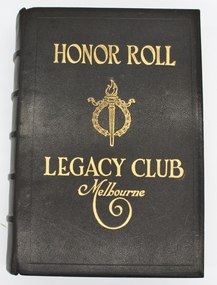
Book, Honor Roll Legacy Club Melbourne
This book is a record, made in honour of deceased Legatees, who have given service to the cause of Legacy. This is labeled Book 3. There are two similar books on display at Legacy House Melbourne.This is a record of Legatees who have given up their spare time to assist the families of deceased service personnel.Black hardcover book, white pages with floral border. Back cover has some scuff marks at the top. Inside front and back cover is decorated with a coloured pattern.Front cover, title and Legacy logo embossed in gold, thin indented rectangular border. Spine has 5 raised horizontal bars set at equal distance down the spine. The raised bars have an indented, horizontal thin line along the top centre and bottom of each bar. These raised bars are interspersed with an indented floral arrangement. At the top and bottom of the spine are two horizontal indented thin lines (2mm apart). Back cover has a thin indented rectangle line as a border. Inside front and back cover, gold embossed border. Pages 4-5 three poems "In Flanders Fields" by Col. John McCrae, KIA Flanders 1916. "The Torch" (The Badge of Legacy). "The Spirit of Legacy". Honor Roll consists of fifty eight pages of deceased Legatees names written boldly, and date of death, in black ink. Thirty two pages pencilled in names of deceased Legatees, waiting to be inked. Remainder of Honor Roll is blank. All pages have a coloured floral border in red with the Legacy logo at the top, centre of the border. honour roll, legatees -
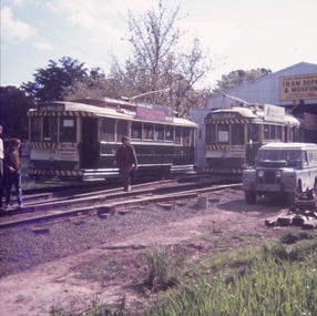 Ballarat Tramway Museum
Slide - 35mm slide/s - set of 3, John Theodore, 1972 - 1974
Yields information about depot activities of the BTPS in building the depot fan and access track.Set of 3 AGFA blue and white plastic mount 27mm sq slides of various works at the BTPS depot during 1972 / 1974 and an event set up with members. .1 - 26 and 40 on the fan with John Withers Landrover. - No. 1 road has been commenced. .2 - group photo of BTPS workers - in front of 27 = special event day given the flagging to the right hand side. .3 - 27 by itself.- track has been laid down the access track.Various notations by John as to the slide number and the trams in pencil and ink.tramways, trams, btps, depot, track construction, group photo, events, tram 26, tram 40, tram 27 -
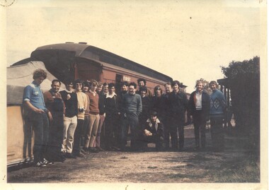 Ballarat Tramway Museum
Photograph - Colour Print, Richard Gilbert, 27/09/1973 12:00:00 AM
Has a strong association with those who travelled on the BTPS organised tour to Mirboo North in 1973.Colour Print of the tour group and loco crew on the BTPS arranged special train to Mirboo North on 27/9/1973 at Yinnar station. Printed on Kodak paper. See Reg items 1817, 1819 and 3274 for other related items. Names: Fireman, Driver, Terry Oakley, Geoff Cargeeg, Alan Harnwell, Clyde Croft, Richard Gilbert, Rolf Jinks, ?., Peter Winspur, John Withers, Warren Doubleday, Peter Rees, Graham Jordan, Tom Murray, John Wayman, Rob McUtcheon, Bill Kingsley and Jeff Bounds kneeling down."BTPS Mirboo North Tour / Thurs 27-9-73 at Yinnar" in ink on rear.trams, tramways, btps, tours, special trains, morwell mirboo north -
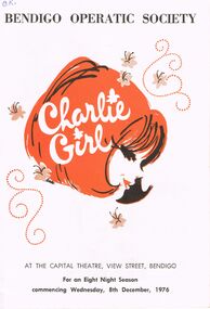 Bendigo Historical Society Inc.
Programme - BENDIGO OPERATIC SOCIETY ''CHARLIE GIRL''
Bendigo Operatic Society ''Charlie Girl'' At the Capital Theatre, View Street Bendigo For an Eight night Season Commnecing Wednsday 8th december, 1976. Producere: Max Collis - Assistant Producer, Wardrobe and Ballet Mistress: Madge Welch - Stage Manager: Malcolm Cannon - Musical Director: Gwen Grose - Society Pianist: Diana Cohn. Cast in Order of Appearance: Bill May as Pete - Malcom O'Brien as Fred - Trevor Boyd as Jerry - Bruce Ashman as Sam - Michelle Hocking as Lady Fiona - Annette Beckwith as Lady Penelope - Carol McKenzie as Lady Hadwell - Dorothy Kennedy as Charlie - Michael Nolan as Nicholas Wainwright - Ken Deuthmann as Joe Studholme - Trevor Cartwright as John Sasaki - Larry Bequir as Jack Connor - Phyllis Downing as Mrs. Kay Connor.program, theatre, bendigo operatic society -
 Bendigo Historical Society Inc.
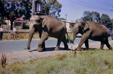
Slide - Images by Arthur Pulfer, 1957-1970
ROSEVIEW 407 High Street, Golden Square Bendigo "Roseview" was designed by Godfrey Eathorne and constructed in 1939. It is one of the few Streamline Moderne houses in the Central Goldfields region, and was one of the earliest constructed in the Bendigo region. It is an outstanding example of this style of housing. It resembles an ocean liner, and reflects the emphasis on the streamlining of methods of transportation. It utilizes both flat and curved surfaces and has little external ornamentation. The use of materials such as rounded glass windows and metal window and door frames reflects an innovative approach to construction consistent with the style. "Roseview" was constructed on a large scale, with large and spacious rooms. It reflects the prominent social status and wealth of the original owner, together with the desire for a building in 'the latest' style which was sure to attract attention and prominence in the region. It has been maintained largely in original condition. CARALULUP HOTEL 'The Sun' dated January 17, 1941 on the back. It states that 'The licence of Caralulup Hotel, near Talbot, has been surrendered, thus severing an 80 year association with the district' State Library of Victoria TOLMER GOLD ESCORT ROUTE The gold rush in New South Wales and Victoria left few able miners in South Australia. Bad economic conditions saw more than 15,000 men leave the Kapunda and Burra mines by the end of 1851. Alexander Tolmer, Commissioner of Police in 1852 proposed that the gold won by South Australians should be brought back to South Australia under an escort consisting of only a few men. In March a Gold Escort was on its way back to Adelaide with almost 6,000 ounces of gold for the vaults of the Treasury Building. After this successful trip Tolmer led two other escorts before handing over his duties. A total of eighteen gold escorts were made, the last one during November and December 1853 when Inspector Wyndham was in charge. You’ll find Gold Escort Route Monuments between Meningie, Coonalpyn and Tintinara.Many images from by Arthur Pulfer copied to slides. Twenty Slides of Bendigo: Bullen's Circus Bendigo February 1966 "Roseview", Pethard's Home at 407 High Street, Golden Square, Bendigo. 25th March 1957. House is possibly on the Midland Highway Epsom, Bendigo - 8 April 1955 Kangaroo Flat Bus Lines mini bus The Big Tree Sedgwick Road March 1972 The old Golden Gully Hotel Diamond Hill Road, Bendigo The old Lockup Eaglehawk Bendigo September 1967 Market Gardens - possibly North Bendigo North Deborah Mine photo taken from Breen Street 1958 Laying the track to get the engine into the park, looking down Mitchell Street Bendigo Engine R766 in the Victorian Railways Institute Park Railway Place Bendigo On the Methodist Church Steps Arnold street Bendigo Miner's Hut at Moliagul Basket Lunch - White Hills Botanical Gardens - St johns 100 year celebrations White Hills Swimming Pool February 1970 White Hills Botanical Gardens Bendigo Bendigo Show Parade 1958 The Arrival of the Cobb and Co Coach in Bendigo September 1963 history, bendigo, james lerk collection, golden square high school, dragon loong, white hill botanical gardens, 407 high street bendigo, r766 engine, bullens circus, caralulup, moligual, bendigo show, tolmer's gold route, kangaroo flat bus lines, eaglehawk lockup, arnold street methodist church, elephants