Showing 572 items
matching land surveyed
-
 City of Moorabbin Historical Society (Operating the Box Cottage Museum)
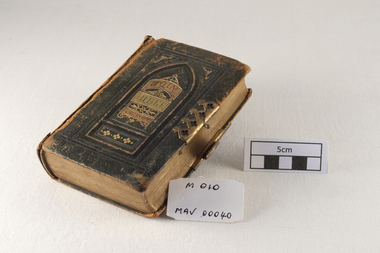
Functional object - Sewing Machine, Melber, Early 20th Century
Melber sewing machines were first sold in Australia in the late 1870s. The 'Box Cottage' Melber Treadle Sewing Machine was owned by Mary Box, nee Kloster / Closter, wife of Alonzo Box , the nephew of William and Elizabeth Box who purchased 'Box Cottage' in 1865 from a pioneer settler The machine was bought in 1909, and is a good example of its kind. This type of sewing machine was widely used in many homes, in an era when hand-made clothes were the “norm.”, and clothes were mended, or ‘re-made’ into another garment. The cottage has both the Receipt, cat 00004.1 and Guarantee, cat 00004.2, for the sewing machine. This machine was possibly built by Wertheim Pty Ltd Hugo Wertheim (1854 – 1919) arrived in Melbourne in 1875. He became a successful agent for sewing machines manufactured by his father’s cousin Joseph Wertheim in Frankfurt, Germany. Hugo married Joseph’s daughter Sophie Emilie and they settled in Richmond Melbourne Australia. Hugo made many trips back to the main factory in Germany and, with extensive advertising, established a thriving business for sewing machines, bicycles, pianos under various ‘brand names’ - Wertheim, Electra, Planet, Griffin, Hapsburg. It has been said that Dame Nellie Melba preferred a Wertheim piano for her performances. In 1908 Hugo opened a large piano factory in Bendigo St Richmond, Victoria and his son Herbert maintained the business until 1935 The sewing machine was donated in 1985 by, a descendant of the Box family. The machine is complete, and in good condition. William and Elizabeth Box purchased 'Box Cottage' in 1865 from a pioneer settler who had bought part of the land noted in Dendy's Special Survey 1841 Brighton. They raised their family there and established a market garden to supply produce to the population of Melbourne. Their nephew Alonzo married Mary Kloster/ Closter in 1918 and she brought with her this 'Melber' sewing machine that she used to provide clothing for the family. 'Melber'Treadle Sewing Machine that was owned by Mary Box, nee Kloster/ Closter. It was bought in 1909, and it is a good example of its kind. This type of sewing machine was widely used in many homes, in an era when hand-made clothes were the “norm.”, and clothes were mended, or ‘re-made’ into another garment. The Box Cottage Museum has both the Receipt, and Guarantee for the sewing machine. 'MELBER' stamped on sewing machine.dendys special survey, treadle sewing machine, box cottage, mary kloster, alonzo box, melber, wertheim hugo, wertheim sewing machine manufacturer, richmond melbourne victoria, -
 City of Moorabbin Historical Society (Operating the Box Cottage Museum)
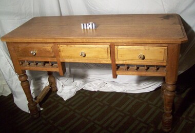
Furniture - Table, small hardwood, circa1850
A small, hard-wood table with decorative spindles, three drawers, and turned legs is from the original pioneer cottage built on land that was part of the Dendy's Special Survey 1841 . Now 302 Jasper Road Ormond. The table is in fair condition, but not complete. It is thought that the original drawer handles most likely deteriorated or were broken over the years. An unknown person replaced the original handles with modern glass knobs, in the late 1970’s. This table was in the original pioneer cottage which is now Reconstructed Box Cottage Museum. An unknown pioneer built the Cottage circa 1850 and it was purchased by William Box in 1865. William and Elizabeth Box lived in the Cottage until 1914 when it was sold to August Reitman who resided there until 1950. In 1964 the Cottage was moved to the present site , Joyce Park, adjacent to 302 Jasper Road Ormond A small, hard-wood table with decorative spindles, three drawers, and turned legs is from the original pioneer cottage built on land that was part of the 1841 Dendy's Special Survey The table is in fair condition, but not complete. It is thought that the original drawer handles most likely deteriorated or were broken over the years. An unknown person replaced the original handles with modern glass knobs, in the late 1970’s. moorabbin, table, ormond, bentleigh, pioneer, dendy henry, box william, market gardener, reitman august, dendy special survey -
 City of Moorabbin Historical Society (Operating the Box Cottage Museum)
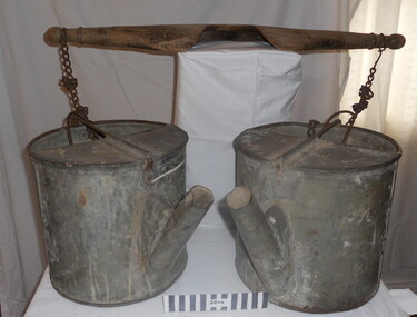
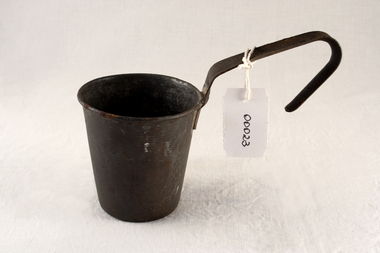
Tool - Chinese Market-Gardener's Watering-Cans
Chinese market-gardener’s watering-cans on a wooden yoke. This item was authenticated by the Bendigo Historical Society, and is said to be quite rare. It consists of two large galvanized watering-cans each with a pouring spout, suspended by chains from a well-used wooden yoke. The cans would each have been filled with water, then carried a distance into the market garden and used to water crops. The cans and yoke alone are very heavy, one can only imagine how heavy they were when filled with water.As profits from the gold-fields petered out the Chinese immigrants, (nearly all single men), were forced to seek other occupations. Many moved into furniture building in the East Melbourne area, whilst others went into market gardening . A significant number of Chinese men, realising the potential of the sandy, fertile soil, with a good supply of water, in the Shire of Moorabbin, leased tracts of land in that area to establish a market garden and grow produce for the increasing population of MelbourneAfter the Dendy Special Survey in1841in Brighton, Victoria, the first sale of Crown Land, taking in the whole Shire of Moorabbin, occurred in 1852. These allotments of land were eagerly bought up - some by speculators - although many were either worked by the owner, or leased out as market gardens and "fruit gardens", (orchards). Chinese market-gardener’s watering-cans suspended by chains on a wooden yoke. This item was authenticated by the Bendigo Historical Society, and is said to be quite rare. It consists of two large galvanized watering-cans each with a pouring spout, suspended by chains from a well-used wooden yokebrighton, gardeners, bentleigh, orchards, vegetables, dendy henry, market gardens, chinese settlers, pioneers moorabbin, water wells, creeks -
 City of Moorabbin Historical Society (Operating the Box Cottage Museum)
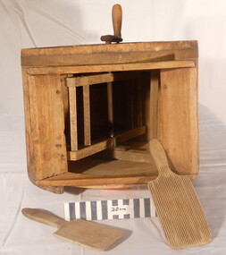
Functional object - Butter churn domestic, circa 1800s
... of Moorabbin. After the sale of land following 'Dendy's Special Survey ...Circa late 1800s. Wooden domestic butter-churn. This is a paddle churn, a barrel that contains a paddle, which is operated by a handle. The paddle churned the butter inside the container when the handle was turned. Early settlers had to be self sufficient, growing their own vegetables, making tools and clothing and usually had a house cow to produce their milk supply. An unsigned note states it was used by a Chinese market-gardener’s family. From the mid 1800s into the1900s, there were numbers of Chinese market gardeners working in Bentleigh, Moorabbin, Mc Kinnon, and Cheltenham in the Shire of Moorabbin. After the sale of land following 'Dendy's Special Survey' 1841 many Chinese settlers rented allotments and established market gardens in the area and sold their produce to the increasing population of Melbourne at the markets in St Kilda and Melbourne.Circa late 1800s. Wooden domestic butter-churn consisting of a wooden barrel with a lid and a crank that manually turned a paddle inside to separate the butter fat from the butter milk 'BUTTER CHURN' written in chalk undated, unsignedchinese, melbourne, brighton, moorabbin, butter, cows, milk, pioneers, dairy, settlers, fruit, bentleigh, markets, mckinnon, cheltenham, vegetables, dendy henry -
 City of Moorabbin Historical Society (Operating the Box Cottage Museum)
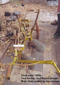
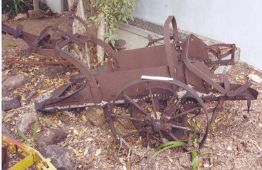
Tool - Farm Machinery, Horse-drawn Furrow Plough, Early 20th Century
Late 1800s-early 1900s A horse-drawn furrow plough is an example of the type of farm implement widely used by pioneer market gardeners in the Moorabbin Shire following 'Dendy's Special Survey' of 1841 and the Crown Land Sale in 1852. Land allotments were bought by pioneer settlers who established or rented allotments for market gardens in the area. They supplied produce to the markets in St Kilda and Melbourne. During the gold-rush of the 1850s the rapidly increasing population of Melbourne saw a huge demand and a rise in prices for all foodstuffs, including the vegetables and fruit grown in the Shire of Moorabbin. This heralded a time of prosperity for market gardeners, and an equally rapid expansion of the numbers of vegetable and produce growers in the area. The 'knock-on effect" resulted in an increased interest and development of the community in the Shire of Moorabbin.Following 'Dendy's Special Survey' of 1841 and the Crown Land Sale in 1852, land allotments were bought by pioneer settlers who established or rented allotments for market gardens in the area and they supplied produce to the markets in St Kilda and Melbourne. During the gold-rush of the 1850s the rapidly increasing population of Melbourne saw a huge demand and a rise in prices for all foodstuffs, including the vegetables and fruit grown in the Shire of Moorabbin. Circa late 1800's to early 1900s. A horse-drawn furrow plough was the most common type of agricultural implement used by the pioneers of the 1800s and continued on into the 1940s when motorised tractors came into use. This plough is an example of a two furrow, mullboard plough which would most likely have been pulled by two horses. The long handle was used to lower the silver plates, (mullboards), to the chosen depth of soil. Painted yellow. Although this Box Cottage museum plough is unbranded, the most widely used plough in the Shire of Moorabbin was made by Oliver. This plough appears to be identical to that brand. brighton, moorabbin, pioneers, fruit, bentleigh, vineyards, vegetables, plough, market gardens, plow -
 City of Moorabbin Historical Society (Operating the Box Cottage Museum)
Tool - Farm Machinery, Horse-drawn Plough Potato Digger, c1900
Circa late 1800s early 1900s a horse-drawn plough, potato digger, is one example of the implements that were widely used by early market gardeners in the Shire of Moorabbin. The flat plate, seen to the right of the photo, dug down into the ground below the potatoes and "scooped" them up. Behind the plate, two driving chains on cogs, (these chains are missing from our exhibit), then "rocked' the dug potatoes to loosen the soil from the "spuds". The potatoes were then harvested by hand. Very large tracts of land in the Shire of Moorabbin were planted with potatoes. Harvesting commenced in October, into November and on into December. Potatoes were a necessary food staple. The market gardeners were always in a rush to be first to get their potatoes to market, and hence the best price. Some market gardeners were so keen to be the first to market, (and get the most money), that they dug their potatoes "green" (or new). The only downside of this practice was that these early potatoes had to be handled with extreme care as their skins were very loose, and came off easily - so decreasing their profits.As well as taking their produce to the Melbourne and St Kilda markets, they also sent produce off to Sydney markets. It is interesting to note that a group of Chinese market gardeners were the first to access the Sydney market. .Following the 'Dendy's Special Survey' 1841 and the Crown Land Sale of 1852, land allotments were sold to pioneer settlers who established market gardens in the area of Moorabbin Shire. During the 1850s gold-rush population boom the number of market gardeners increased significantly spreading throughout the Moorabbin Shire. Potatoes were considered a staple foodstuff, so crops were regularly sown throughout the whole Moorabbin area. Circa late 1800s early 1900s. A horse-drawn plough potato digger is an example of the machines used by early market gardeners in Moorabbin Shiremelbourne, sydney, markets, vegetables, potato, dendy henry, st kilda, market gardeners, gold rush, moorabin, chinese gardeners, ploughs -
 City of Moorabbin Historical Society (Operating the Box Cottage Museum)
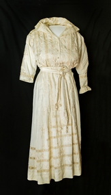
Clothing - Wedding Dress, Mary Box (nee Closter), circa 1918
Alonzo Box, of Oakleigh ,a nephew of William and Elizabeth Box who resided in 'Box Cottage' 1865 - 1914, married Mary Closter (Kloster), of Oakleigh, on June 12th 1918. Alozo's elder sister, Rebecca, sent a bolt of Chinese hand-embroidered silk from which this wedding dress was made. Rebecca Viloudakia, nee Box, was a missionary in China, and married to a Greek Silk Merchant. Alonzo Box, the 9th child of John and Martha Sheldrake Box , enlisted in the Army and landed at Gallipoli 25/4/1918. He was evacuated to Egypt and then sent to the battlefields of France and Flanders before returning home to Melbourne in February 1918. Rebecca Box, the eldest child of John and Martha Sheldrake Box, was in the first party of Methodist Missionaries to leave Australia for the China Inland Mission in 1890. During the Boxer Uprising 1900-1901 her Mission outpost was attacked but she escaped and was taken to Shanghai. She later married one of the rescue party Nicholas Viloudakia a Greek silk merchant .Australian Dress Register ID 573 12/5/2015 Following Henry Dendy's Special Survey 1841 pioneer settlers bought allotments of land in the area of Moorabbin Parish. Alonzo Box was the nephew of William and Elizabeth Box who bought the cottage on the 30acre allotment from an unknown pioneer settler in 1868 and resided there until Elizabeth's death in 1914. Alonzo Box served in the Army World War 1 1914- 1918 at Gallipoli, France and Flanders. Rebecca Box -Viloudakia was in the first party of Methodist Missionaries to leave Australia for the China Inland Mission in 1890 and was rescued during the Boxer Rebellion 1900-1901 and taken to Shanghai by her future husband.A cream two piece wedding dress made from a bolt of hand embroidered Chinese silk for the marriage of Mary Closter and Alonzo Box on June 12th, 1918. The bolt of Chinese silk was sent by Alonzo’s older sister, Mrs Rebecca Viloudakia, a missionary in China, who was married to a Greek silk merchant. The machine sewn dress was made by a dressmaker in Dandenong, Victoria. The jacket is blouson, with a front opening and is gathered at the waist by a band enclosing a drawstring. The collar is a sailor style that forms a slight / high V-shape front neckline. Four vertical roses are separated by three bands of lacework. The back of the jacket is plain silk. The right front of the jacket has a panel of embroidered roses, band of lacework and a facing fold that encloses 4 fastening presses. There are crocheted bobbles on the front representing buttons. The left jacket front also has the panel of embroidered roses, lacework and matching fold for the 4 fastening studs. The full length inset sleeves are gathered to a cuff that fastens with silk covered buttons. The sleeves have floral embroidery down the outside centre line. The left sleeve has an extra detachable cuff with embroidery on the flounce that matches the bottom panel of the skirt. It is held in position around the wrist by 4 white metal press studs. The skirt sits above the ankle. It consists of 5 panels slightly gathered at the back waistline with a left side placket 21cm with hooks and eyes and press studs. The waistband is lined with petersham and has 6 whalebone inserts. The front of the skirt has small pleats to fit the 3 decorated panels to the waistline. The front has 3 bands of lacework around the lower part. 3 panels form the centre front each embroidered with a different floral pattern. The back of the skirt is plain with 3 bands of lacework rising from the hem, which is sewn with spoke work stitch. The long waist sash/belt is plain silk with embroidered ends and 3 silk balls with crocheted caps suspended on 3 crocheted silk chains. It has a rose knot with 2 metal press stud fasteners. There are a variety of floral designs embroidered on the material including ‘corner motifs’ on the 2nd inner front panel of skirt. brighton, moorabbin, silk, box william, box elizabeth, box alonzo, box mary, kloster mary, closter mary, oakleigh, dandenong, chinese silk merchant, boxer rebellion 1900-1901, box rebecca, methodist china inland mission, viloudakia nichols, anzac landings, world war 1, gallipoli -
 City of Moorabbin Historical Society (Operating the Box Cottage Museum)
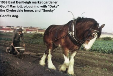
Photograph - Photograph: Horse-drawn Plough at Work, 1969 Geoff Marriott ploughing in his Market Garden, 1969
Members of the Marriott family arrived in Port Phillip in 1857. However it was John and Jane Marriott who in 1876, (after toiling hard since their arrival in1871, for very little gain), first leased, then purchased in 1882, 30 acres with a four-roomed house in East Boundary Road, in the area then called East Brighton. (Now known as East Bentleigh). The land they purchased had previously been a part of the 1841 Dendy Survey. Over the following years, John and his four sons with hard work and determination became prosperous vegetable growers and purchased further land in the area. Following John's retirement and subsequent death in 1903, the land was passed to his sons, and then onto the Marriott grandchildren. The family continued to remain very prosperous and successful vegetable growers. This lovely photo of Geoff Marriott bears testament to just one of the many families steeped in the tradition of vegetable growing which significantly contributed to the prosperity of the Shire, and its subsequent development into the City of Moorabbin. The photograph of Geoff Marriott of the Marriott family represents a typical example of the MANY early market gardening families, some names less prominent, but who with their labours contributed to the prosperity and the development of the community of the Shire of Moorabbin. This group of early pioneers, over many years, were a singularly important group responsible for the growth of schools, churches, the Mechanic's Hall, and were active in local government. Large coloured photograph, taken in 1969, showing Mr Geoff Marriott with his horse-drawn plough pulled by "Duke" the Clydesdale horse, and accompanied by "Smoky", his dog, working in his market garden, Brady Road, East Bentleighhorse, brighton, moorabbin, pioneers, settlers, fruit, markets, vegetables, plough, mayors, moorabbin shire, moorabbin roads board, marriott geoff, marriott john, marriott jane, market gardens, horse drawn plough, city of moorabbin -
 City of Moorabbin Historical Society (Operating the Box Cottage Museum)
Photograph - Map of Dendy's Special Survey, 1852 Map of Henry Dendy's Special Survey of 1841, 19th Century
A Map drawn in 1852 that shows the 5,120 acres that formed Dendy's Special Survey of 1841. In 1840 Henry Dendy, a farmer in Surrey, England acquired a "Special Survey" from the Commissioners for Land and Emigration which gave Dendy the right to choose land in Port Phillip for the "bargain basement" price of only £1 per acre for 5120 acres, (an area of 8 square miles). The Special Survey also included the right to "the shipment of a worker for every £20 spent on land, whose free passage was paid by the Crown, equalling a total of 100 workers ". Accordingly Dendy sold his English holdings and paid the required £5120 and arrived in Melbourne in February 1841. However by this time land in the new colony was selling for £5 - £40 per acre. Because Henry Dendy possessed the order from the Colonial Office in London he was able to successfully oppose Governor LaTrobe's attempts to alter the price of the land. Dendy appointed Jonathan Were, (an entrepreneur, who had arrived in 1839), as his Manager and who later became a partner. Together, Dendy and Were decided on an area 5 miles south from Melbourne, bounded by North Road, East Boundary Road, South Road and to the west by Port Phillip Bay. Were and Dendy pitched their tents in the area now known as ' Park St, Brighton' and sank a well near the corner of 'St Andrew's St and Wells St'. By 1845 J.B Were and Company had bought almost half of Dendy's land and Were built himself "Moorabbin House" in Were St Brighton made from stone, quarried from local cliffs. It was still standing in 1924. Legend records Moorabbin is named after the Aboriginal word for ' Mother's Milk ' The soil is very fertile and well supplied with water especially in the area called 'East Brighton' - now known as Bentleigh and East Bentleigh - By 1850 the area had developed with numerous market gardens, dairy farms, fruit gardens and vineyards supplying food for the growing population of Melbourne.This Map shows the birth of the Brighton and Moorabbin area. On 18th January1859 Brighton was proclaimed a Municipality and a Borough by October 1863. Meanwhile, following a Petition, the area of East and South Brighton, incorporating Mordialloc, Cheltenham, Mentone, Sandringham and Oakleigh separated from Brighton to form the Moorabbin District Roads Board becoming the first Local Government Authority. Col. William Mair was elected as the first Chairman of the Moorabbin Roads Board. Moorabbin Shire 1871 developed further and was declared a City in1934. The City of Moorabbin was the largest Municipality in Melbourne before the Amalgamation of Councils in 1994 when it was divided in the south to City of Kingston and in the north to City of Glen Eira A Photo-lithographed 1852 Map showing the 5,120 acres that formed Dendy's Special Survey of 1841. Henry Dendy & Jonathan Were chose an area 5 miles south from Melbourne, bounded by North Road, East Boundary Road, South Road and to the west by Port Phillip Bay. Moorabbin County of Bourke / Photo-Lithographed at the department of Lands and Survey. /Melbourne. / Price 1/- brighton, moorabbin, bentleigh, cheltenham, dendy henry, bent thomas, were jonathan, special survey -
 City of Moorabbin Historical Society (Operating the Box Cottage Museum)
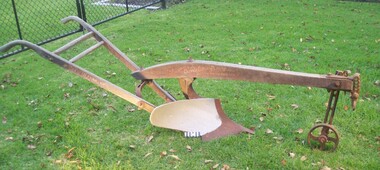
Photograph - Farm Machinery, Plough, single mull-board, c1900
Circa late 1800's to early 1900s. A horse-drawn furrow plough was the most common type of agricultural implement used by the pioneer market gardeners, in Moorabbin Shire, of the 1800s and continued on into the 1940s when motorised tractors came into use. This plough is an example of a single-mullboard plough which would have been pulled by horse. The long handle was used to lower the silver plate, (mullboard), to the chosen depth of soil. Following 'Dendy's Special Survey' of 1841 and the Crown Land Sale in 1852, land allotments were bought by pioneer settlers who established or rented allotments for market gardens in the area and they supplied produce to the markets in St Kilda and Melbourne. During the gold-rush of the 1850s the rapidly increasing population of Melbourne saw a huge demand and a rise in prices for all foodstuffs, including the vegetables and fruit grown in the Shire of Moorabbin. An "Oliver" single mull-board plough in good condition with faded manufactures markings on shaftsPainted on shaft "MANF'D BY/OLIVER CHILLED PLOW WORKS/Southend Ind. USA/" Engraved on blade " 13 OLIVER"brighton, moorabbin, plough, dendy henry, east bentleigh, market gardens, horse drawn plough, plow, mullboard -
 City of Moorabbin Historical Society (Operating the Box Cottage Museum)
Clothing - Clothing, girl's party dress c 1927, 1927
This child's green, silk, party dress was worn by Sylvia Marriott in 1927. The Marriott family were early settlers in the Moorabbin ShireMembers of the Marriott family arrived in Port Phillip in 1857. However it was John and Jane Marriott who in 1876, (after toiling hard since their arrival in1871, for very little gain), first leased, then purchased in 1882, 30 acres with a four-roomed house in East Boundary Road, in the area then called East Brighton. (Now known as East Bentleigh). The land they purchased had previously been a part of the 1841 Dendy Special Survey. Over the following years, John and his four sons with hard work and determination became prosperous vegetable growers and purchased further land in the area. Following John's retirement and subsequent death in 1903, the land was passed to his sons, and then onto the Marriott grandchildren. The family continued to remain very prosperous and successful vegetable growers and are one of many families steeped in the tradition of vegetable growing which significantly contributed to the prosperity of the Moorabbin ShireA home-sewn pale green silk party dress, worn to a wedding by four year old, Sylvia Marriott c 1927. The skirt of the dress has layers of ruffles. It has short cap sleeves. Decorative ribbons are attached at the shoulder continueing to the waist, then hang loosely over the skirt of the dress. Small pink and white ribbon rose buds have been applied at the neckline, waist and the edges of the sleeves .brighton, moorabbin, marriott, clothing, market gardeners, home, dressmaker, needlework, dendys special survey -
 City of Moorabbin Historical Society (Operating the Box Cottage Museum)
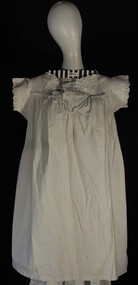
Clothing - Clothing, girl's nightgown, c1900
A typical, white ,cotton, nightgown worn by girls c1900.. it was probably made by her mother who usually made all the clothes for the family. The pioneer settlers and market gardeners in the Moorabbin Shire had to be very self reliant and make their own clothes and utensils. Many early settlers came to rent and eventually buy land after the 1841 Dendy Special Survey in Brighton Victoria. These settlers developed market gardens and supplied the growing Melbourne population with produce . They had to make their own clothing and this is an example of their dressmaking craftsmanship.A white, cotton, girl's nightgown is typical of those worn c 1900clothing, brighton, moorabbin, pioneers, dendy henry, box elizabeth, market gardeners -
 City of Moorabbin Historical Society (Operating the Box Cottage Museum)
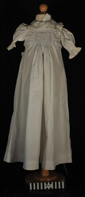
Clothing - Clothing, baby's nightgown, c1900
The pioneer settlers and market gardeners who came to the Brighton area after the 1841 Dendy Special Survey had to be self reliant. The women made most of the clothing for their families and many items on display exhibit their skill and craftsmanshipThis is a typical garment made by the women pioneer settlers in the Brighton area after the sale of land in the Dendy Special Survey 1841. By 1900 the area was known as Moorabbin Shire and the successful market gardeners were supplying the population of Melbourne with produce.This is a baby's long white cotton nightgown with a frilled collar and waist ties, typical of that made c 1900 an worn in Moorabbin Shiremelbourne, brighton, moorabbin, dendy henry, market gardeners, dressmakers -
 City of Moorabbin Historical Society (Operating the Box Cottage Museum)
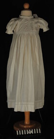
Clothing - Clothing, baby's long dress pin-tucked, c1900
This long, white cotton pin-tucked baby's dress is an example of the clothing the women of pioneer settlers and market gardeners in Moorabbin Shire made for their familiesAfter the 1841 Dendy Special Survey of Brighton, Victoria, allotments of land were rented or sold to pioneer settlers. These settlers had to be self reliant and the women made most of the clothing for their families. This garment is one of the examples of the skills and craftsmanship of these women.A white, cotton, pin-tucked, long Baby's dress c 1900clothing, brighton, moorabbin, dressmaking, dendy henry, market gardeners, pioneer settlers, craft working -
 City of Moorabbin Historical Society (Operating the Box Cottage Museum)
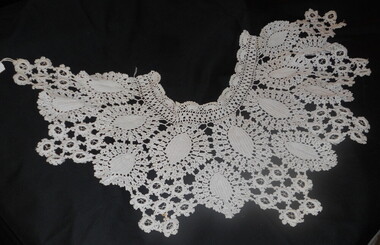
Clothing - Clothing, lace collar, c1880
This heavy, detachable lace collar is an example of the dressmaking and needle work skills of the women of the families of the pioneer settlers and market gardeners of the Moorabbin Shire c 1880 The Maggs family settled in the Brighton district in the late 1800,s. After the Dendy's Special Survey of the Brighton area in 1841 land allotments were rented or sold to pioneers who established market gardens, dairy farms, fruit gardens and vineyards. The pioneer settlers and market gardeners of Moorabbin Shire had to be self reliant and made their own clothing and utensils. This is one of many items that exhibit the skill and craftsmanship of the women in these familiesThis heavy, lace collar is detachable and consists of hand crochet work.clothing, crochetwork, pioneers, early settlers, dendy henry, maggs geoff, brighton, bentleigh, moorabbin, market gardeners, craft working, dressmakers -
 City of Moorabbin Historical Society (Operating the Box Cottage Museum)
Functional object - Kitchen equipment, water-dipper, c1920
Early settlers could only obtain clean water by sinking a well on their land. A pump was built to draw water for use by the family and this tin dipper would have been used for drinking water. The Lachlan Mackinnon family were early settlers in Moorabbin ShireEarly settlers had to sink wells on their land and build water pumps in order to obtain water. This tin dipper would have been used for drinking at the water pump . In 1846 Lachlan and Charles Mackinnon bought 117 acres of land in the 'Dendy's Special Survey' from J.B.Were This area is now known as the suburb of 'McKinnon' and may have been named after them.A tin water-dipper for obtaining drinking water from water pumpmoorabbin, wells, water supply, pioneers, ormond, bentleigh, mckinnon, market gardeners, early settlers, kitchen equipment, water pumps, mackinnon jessie, mackinnon donald, mackinnon lachlan, mackinnon charles, mackinnon daniel -
 City of Moorabbin Historical Society (Operating the Box Cottage Museum)
Book - Rites, Bible 1874, THE HOLY BIBLE, 1874
A Bible used by Mr James Jones, an early settler in Moorabbin Shire, from 1880 - 1940James Jones was the son of Philip Jones, a Chairmaker, and Ann Jones who settled in East Brighton after the sale of land c1852 in the area of the Henry Dendy Special Survey of 1841. Mary Ann Moore was the daughter of Thomas Moore, a Gardener, and Sarah Harris who also settled in Brighton c1852. James and Mary Ann Jones settled and raised their family in East Brighton now Bentleigh. Mr John Herron resided at 4 Vickery St Bentleigh until 1989.A Bible of Mr James Jones 1874Front cover THE HOLY BIBLE inside page THE/ HOLY BIBLE/ CONTAINING THE / OLD AND NEW TESTAMENTS/ APPOINTED TO BE READ IN CHURCHES/ herron john, jones james. early settlers, pioneers, collins william, printers, publishers, bibles, church of england, prayer books, moorabbin, brighton, melbourne, glasgow, scotland -
 City of Moorabbin Historical Society (Operating the Box Cottage Museum)
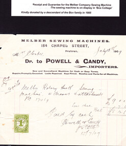
Document - Receipt, c1900
Mrs Martha Closter ( Kloster), of Oakleigh purchased the Melber Sewing Machine in 1909 and gave it to her daughter Mary when she and Alonzo Box married in 1918 and settled in Moorabbin Shire. This document was donated by a descendant of the Box family in 1985.William and Elizabeth Box purchased 'Box Cottage' in 1865 from a pioneer settler who had bought part of the land noted in Dendy's Special Survey 1841 Brighton. They raised their family there and established a market garden to supply produce to the population of Melbourne. Their nephew Alonzo married Mary Kloster/ Closter in 1918 and she brought with her the 'Melber' sewing machine that she used to provide clothing for the familyThe original paper Receipt of the Melber Company Sewing Machine, 154 Chapel Street Prahran on July 15th 1909. Mrs Closter purchased a ‘Melber Rotary Hook Sewing Machine , 4 drawers and attachment. No. 17469 costing 9 pounds, less due 7 shillings and 6 pence leaving the sum of 8 pounds 12 shillings and 6 pence Paid by Cash to Powell & Candy per ……… on 15/7/09 ( hand written ) MELBER SEWING MACHINES / 154 CHAPEL STREET, / Prahran / Mrs Closter July 15th 1909 ( handwritten) / Dr. to POWELL & CANDY, / IMPORTERS / New and Secondhand Machines for Cash and Easy Terms. / Repairs promptly executed Locks repaired. Keys fitted. Needles and Parts for all Machines. A stamp 25mm x 30mm is on left corner of document ‘ VICTORIA STAMP DUTY ‘ -at top and base - ‘1d ‘ - centrally victoria, melbourne, clothing, brighton, moorabbin, pioneers, sewing, box elizabeth, box alonzo, closter mary, kentucky, early settlers, america, craftwork, sewing machines, melber company, u s a, prahran, kloster martha -
 City of Moorabbin Historical Society (Operating the Box Cottage Museum)
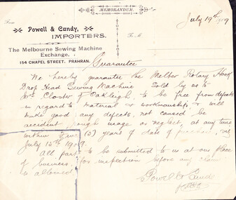
Document - Guarantee, c1900
Mrs Martha Closter ( Kloster), of Oakleigh purchased the Melber Sewing Machine in 1909 and gave it to her daughter Mary when she and Alonzo Box married in 1918 and settled in Moorabbin Shire. This document was donated by a descendant of the Box family in 1985.William and Elizabeth Box purchased 'Box Cottage' in 1865 from a pioneer settler who had bought part of the land noted in Dendy's Special Survey 1841 Brighton. They raised their family there and established a market garden to supply produce to the population of Melbourne. Their nephew Alonzo married Mary Kloster/ Closter in 1918 and she brought with her this 'Melber' sewing machine that she used to provide clothing for the family The original, hand written, Guarantee for the Melber Sewing Machine purchased by Mrs Martha Closter of Oakleigh in July 15th 1909 at Powell & Candy, Importers of Chapel Street, Prahran, Melbourne. MEMORANDUM / From / Powell & Candy/ IMPORTERS / ‘ July 19th 1909 ‘ ( hand written) / To M / The Melbourne Sewing Machine / Exchange, / 154 CHAPEL STREET, PRAHRAN / Guarantee ( hand written) / “ We hereby guarantee the Melber Rotary Hook / Drop Head Sewing Machine Sold by us to / Mrs Closter of Oakleigh, to be free from defects / in regard to material & workmanship & will / make good any defects not caused “be” / accident, rough usage or neglect at any time / within Five (5) years of date of purchase . viz. / July 15th 1909. / All parts to be submitted to us at our place / of business for inspection before any claim / is allowed. / Powell & Candy / per ……..” ( all hand written ) victoria, melbourne, clothing, brighton, moorabbin, pioneers, sewing, box elizabeth, box alonzo, closter mary, oakleigh, kentucky, early settlers, america, craftwork, sewing machines, melber company, u s a, prahran, kloster martha -
 City of Moorabbin Historical Society (Operating the Box Cottage Museum)
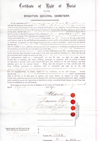
Certificate - Document, Certificate of Burial 1890, c1880
James Jones was the son of Philip Jones, a Chairmaker, and Ann Jones who settled in East Brighton after the sale of land c1852 in the area of the Henry Dendy Special Survey of 1841. Mary Ann Moore was the daughter of Thomas Moore, a Gardener, and Sarah Harris who also settled in Brighton c1852. James and Mary Ann Jones settled and raised their family in East Brighton now Bentleigh. Mr John Herron resided at 4 Vickery St Bentleigh until 1989. Sadly Martha Jones born 1888 died in 1890 and James Jones had to purchase this plot at Brighton General Cemetery for her burial. A further 2 children were interred in 1893 and 1900 then Mary Ann in 1903 and James in 1940 James Jones and Mary Ann Moore were born in Brighton c1857 and c 1859 into pioneer market gardener families in the area of the Dendy Special Survey of 1841. They married in 1883 and raised their family in East Brighton, now Bentleigh. Sadly infectious diseases took the lives of many infants throughout the Colony of Victoria due to the poor state of water supply and sewerage disposal and locally the swamps of the Elster Creek were a constant breeding ground.An original paper Certificate of Right of Burial in The Brighton General Cemetery signed and dated by the Trustees of the Cemetery upon the application of James Jones of East Brighton, Victoria, 22nd April 1890. A plot , Register No. 2844, of 4 feet in width and 8 feet in depth in the Wesleyan Section, No. 199, compartment G in the Brighton General Cemetery. would be supplied upon payment of Two Pounds two shillings and receipt of same is acknowledged. Certificate of Right of Burial / IN THE / BRIGHTON GENERAL CEMETERY. Application of Mr James Jones of East Brighton for a plot to be supplied upon payment of Two Pounds and 2 Shillings and receipt of same acknowledged. Signed by the Trustees of the Cemetery, (4 signatures) in presence of S. Simmonds, dated twenty- second April 1890 Reverse side Dated 22nd April 1890 / Certificate of Right of Burial / IN THE / BRIGHTON GENERAL CEMETERY/ Mr James Jones ( hand written) / DENOMINATION Wesleyan / Compartment G / No. 199 Hand written on right side 3454 (signed) S Simmonds / 4797 (signed) S Simmonds / 36897 20/ 11 / 40 melbourne, brighton, moorabbin, water supply, pioneers, bentleigh, dendy henry, market gardeners, early settlers, jones mary ann, wesleyan church, jones james, vaccination, typhoid, dendys special survey 1841, infectious diseases, elster creek, jones martha, brighton general cemetery -
 City of Moorabbin Historical Society (Operating the Box Cottage Museum)
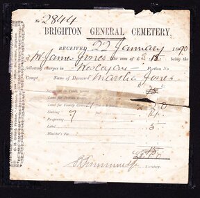
Certificate - Document, receipt burial 1890 Martha Jones, c1880
James Jones was the son of Philip Jones, a Chairmaker, and Ann Jones who settled in East Brighton after the sale of land c1852 in the area of the Henry Dendy Special Survey of 1841. Mary Ann Moore was the daughter of Thomas Moore, a Gardener, and Sarah Harris who also settled in Brighton c1852. James and Mary Ann Jones settled and raised their family in East Brighton now Bentleigh. Mr John Herron resided at 4 Vickery St Bentleigh until 1989. Sadly Martha Jones born 1888 died in 1890 and James Jones had to purchase a plot at Brighton General Cemetery for her burial. A further 2 children were interred in 1893 and 1900 then Mary Ann in 1903 and James in 1940James Jones and Mary Ann Moore were born in Brighton c1857 and c 1859 into pioneer market gardener families in the area of the Dendy Special Survey of 1841. They married in 1883 and raised their family in East Brighton, now Bentleigh. Sadly infectious diseases took the lives of many infants throughout the Colony of Victoria due to the poor state of water supply and sewerage disposal and locally the swamps of the Elster Creek were a constant breeding ground. Martha Jones born 1888 died 1890 and was interred in Brighton General Cemetery in a family plot purchased by her father James Jones. An original paper receipt No. 2844 for payment 22 January 1890 by James Jones to Brighton General Cemetery of 3 pounds 1 shilling for burial of Martha Jones aged approx. 2 years in a plot 4 feet x 8 feet. Fees include family grave at 2 pounds 2 shillings, Sinking to 7 feet at 14 shillings and Label 5 shillings .No. 2844( hand written) / BRIGHTON GENERAL CEMETERY / RECEIVED 22 January 18 90 / of Mr James Jones ( hand written ) the sum of £3. 1 being the / following charges in Wesleyan Portion No. / Compt. Name of deceased Martha Jones / Signed S Simmonds (handwritten) Secretary Along left side G.H Orford Printer “ Southern Cross Office” Bay St. Brighton melbourne, brighton, moorabbin, water supply, pioneers, bentleigh, dendy henry, market gardeners, early settlers, jones mary ann, wesleyan church, jones james, vaccination, typhoid, dendys special survey 1841, infectious diseases, elster creek, jones martha, brighton general cemetery, orford g h, printers, southern cross office, bay street brighton -
 City of Moorabbin Historical Society (Operating the Box Cottage Museum)
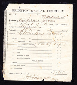
Certificate - Document, receipt Burial 1893 Ethel May Jones, c1890
James Jones was the son of Philip Jones, a Chairmaker, and Ann Jones who settled in East Brighton after the sale of land c1852 in the area of the Henry Dendy Special Survey of 1841. Mary Ann Moore was the daughter of Thomas Moore, a Gardener, and Sarah Harris who also settled in Brighton c1852. James and Mary Ann Jones settled and raised their family in East Brighton now Bentleigh. Mr John Herron resided at 4 Vickery St Bentleigh until 1989. Sadly Martha Jones born 1888 died in 1890 and James Jones had to purchase a plot at Brighton General Cemetery for her burial. Baby Ethel May was interred in 1893 and another baby in 1900 then Mary Ann in 1903 and James in 1940James Jones and Mary Ann Moore were born in Brighton c1857 and c 1859 into pioneer market gardener families in the area of the Dendy Special Survey of 1841. They married in 1883 and raised their family in East Brighton, now Bentleigh. Sadly infectious diseases took the lives of many infants throughout the Colony of Victoria due to the poor state of water supply and sewerage disposal and locally the swamps of the Elster Creek were a constant breeding ground. Martha Jones born 1888 died 1890 and was interred in Brighton General Cemetery in a family plot purchased by her father James Jones. In 1893 another daughter Ethel May died and was buried in the family plot. An original paper receipt No. 3454 for payment on 23 March 1893 by James Jones to Brighton General Cemetery of £1 . 1s For the burial of baby Ethel May Jones in a plot 4 feet x 8 feet, in the Wesleyan section portion 199 compartment G. Fee was for reopening the grave he had purchased in 1890 for the burial of his daughter Martha, aged 2 years . BRIGHTON GENERAL CEMETERY / 3454 ( stamped) / 23 March 1893 ( hand written ) / Received from Mr James Jones ( hand written ) / the sum of £1 . 1s being the following / charges in Wesleyan (hand written) / Portion No, 199 compt.G Name of / deceased Ethel May Jones ( handwritten) / for re-opening grave internment recent ( hand written) £1 . 1s / Signed S Simmonds ( ?manager) Along left side of receipt is printed SOUTHERN CROSS PRINT, BRIGHTON melbourne, brighton, moorabbin, water supply, pioneers, bentleigh, dendy henry, market gardeners, early settlers, jones mary ann, wesleyan church, jones james, vaccination, typhoid, dendys special survey 1841, infectious diseases, elster creek, jones martha, brighton general cemetery, orford g h, printers, southern cross office, bay street brighton, jones ethel may -
 City of Moorabbin Historical Society (Operating the Box Cottage Museum)
Certificate - Receipt for Burial of Stillborn Child, James & Mary Jones Child, 1900
James Jones was the son of Philip Jones, a Chairmaker, and Ann Jones who settled in East Brighton after the sale of land c1852 in the area of the Henry Dendy Special Survey of 1841. Mary Ann Moore was the daughter of Thomas Moore, a Gardener, and Sarah Harris who also settled in Brighton c1852. James and Mary Ann Jones settled and raised their family in East Brighton now Bentleigh. Mr John Herron resided at 4 Vickery St Bentleigh until 1989. Sadly Martha Jones born 1888 died in 1890 and James Jones had to purchase a plot at Brighton General Cemetery for her burial. Baby Ethel May was interred in 1893 and then Mary Ann in 1903 and James in 1940. Their stillborn baby was buried in the Wesleyan public grave in 1900James Jones and Mary Ann Moore were born in Brighton c1857 and c 1859 into pioneer market gardener families in the area of the Dendy Special Survey of 1841. They married in 1883 and raised their family in East Brighton, now Bentleigh. Sadly infectious diseases took the lives of many infants throughout the Colony of Victoria due to the poor state of water supply and sewerage disposal and locally the swamps of the Elster Creek were a constant breeding ground. Martha Jones born 1888 died 1890 and was interred in Brighton General Cemetery in a family plot purchased by her father James Jones. In 1893 another daughter Ethel May died and was buried in the family plot. A stillborn baby was interred in the public grave of Brighton General Cemetery in May1900An original paper receipt No.4360 for payment on 22 May 1900 by James Jones to Brighton General Cemetery of 6 shillings for the burial of a stillborn baby Jones in the Wesleyan section of the public graves. There is no fee for ‘re-opening the grave’ purchased by James Jones in 1890 and in which his daughters Martha 1890 and Ethel May 1893 were interred. BRIGHTON GENERAL CEMETERY / No. 4360 (stamped) 22 May 1900 ( hand written) / Received of Mr Jas. Jones ( hand written) / the sum of 6 s being the following / charges in Wesleyan / Portion No. -- Compt. - Name of / Deceased ‘Stillborn child of Jas / & Mary Ann Jones’ (hand written) Along left side “Brighton Leader” Print, Bay Street, North Brighton This receipt is signed A Shimon man. Secretary wesleyan church, brighton general cemetery, vaccination, pioneers, early settlers, typhoid, brighton, moorabbin, bentleigh, market gardeners, jones james, jones mary ann, jones martha, dendy henry, dendys special survey 1841, infectious diseases, water supply, elster creek, melbourne, orford g h, printers, southern cross office, “brighton leader” print, bay street brighton, jones ethel may -
 City of Moorabbin Historical Society (Operating the Box Cottage Museum)
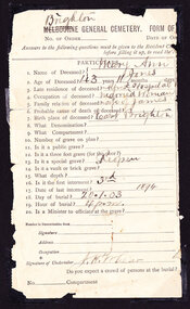
Certificate - Documents relating to Death and Burial of Mary Ann Jones, 1903
James Jones was the son of Philip Jones, a Chairmaker, and Ann Jones who settled in East Brighton after the sale of land c1852 in the area of the Henry Dendy Special Survey of 1841. Mary Ann Moore was the daughter of Thomas Moore, a Gardener, and Sarah Harris who also settled in Brighton c1852. James and Mary Ann Jones settled and raised their family in East Brighton now Bentleigh. Mr John Herron resided at 4 Vickery St Bentleigh until 1989. Sadly Martha Jones born 1888 died in 1890 and James Jones had to purchase a plot at Brighton General Cemetery for her burial. Baby Ethel May was interred in 1893 and then Mary Ann in 1903 and James in 1940. Their stillborn baby was buried in the Wesleyan public grave in 1900James Jones and Mary Ann Moore were born in Brighton c1857 and c 1859 into pioneer market gardener families in the area of the Dendy Special Survey of 1841. They married in 1883 and raised their family in East Brighton, now Bentleigh. Sadly infectious diseases took the lives of many infants throughout the Colony of Victoria due to the poor state of water supply and sewerage disposal and locally the swamps of the Elster Creek were a constant breeding ground. Martha Jones born 1888 died 1890 and was interred in Brighton General Cemetery in a family plot purchased by her father James Jones. In 1893 another daughter Ethel May died and was buried in the family plot. A stillborn baby was interred in the public grave of Brighton General Cemetery in May1900. Mary Ann Jones died at age 43years and was interred in January 19033 Original documents associated with the death of Mary Ann Jones 18th January 1903. 1) An original paper receipt No. 4797 for payment on 19th January 1903 by James Jones to Brighton General Cemetery of £1 . 1s for the burial of Mary Ann Jones in a plot 4 feet x 8 feet, in the Wesleyan section portion 199 compartment G. 2 ) An original part- section of Form of Notification of Death from The Alfred Hospital Prahran with personal particulars and burial details , signed by the Undertaker. 3) An original Mourning Card 1) BRIGHTON GENERAL CEMETERY / 4797 ( stamped) / 19th Jan. 1903 (hand written) / Received from “Mr James Jones”(hand written) / the sum of £1 . 1s being the following / charges in Wesleyan (hand written) / Portion No, 199 compt.G Name of / Deceased ‘Mary Ann Jones”(hand written) / For re-opening grave interment ‘third’ £1 . 1s./ signed by S. P. Simmonds Secretary. 2) ‘Brighton’ (written over Melbourne) GENERAL CEMETERY FORM OF… / No. of Order____ Date of… / PARTICULARS / Signature of Undertaker J H Lear On back of notice are guides to the questions 3) In Loving Remembrance of / Mary Ann Jones / Dearly Loved Wife of James Jones / Died January 18th 1903 / Aged 43 Years / Poem - “One Less at Home “ / DEEPLY REGRETTED / Art Engraving Company, Royal Arcade, Elizabeth Street, Melbourne * wesleyan church, brighton general cemetery, vaccination, pioneers, early settlers, typhoid, brighton, moorabbin, bentleigh, market gardeners, jones james, jones mary ann, jones martha, dendy henry, dendys special survey 1841, infectious diseases, water supply, elster creek, melbourne, orford g h, printers, southern cross office, “brighton leader” print, bay street brighton, jones ethel may, public grave brighton -
 City of Moorabbin Historical Society (Operating the Box Cottage Museum)
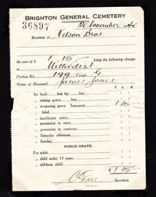
Certificate - Documents, Burial James Jones 1940, c1940
James Jones was the son of Philip Jones, a Chairmaker, and Ann Jones who settled in East Brighton after the sale of land c1852 in the area of the Henry Dendy Special Survey of 1841. Mary Ann Moore was the daughter of Thomas Moore, a Gardener, and Sarah Harris who also settled in Brighton c1852. James and Mary Ann Jones settled and raised their family in East Brighton now Bentleigh. Mr John Herron resided at 4 Vickery St Bentleigh until 1989. Sadly Martha Jones born 1888 died in 1890 and James Jones had to purchase a plot at Brighton General Cemetery for her burial. Baby Ethel May was interred in 1893 and then Mary Ann in 1903 and James in 1940. Their stillborn baby was buried in the Wesleyan public grave in 1900James Jones and Mary Ann Moore were born in Brighton c1857 and c 1859 into pioneer market gardener families in the area of the Dendy Special Survey of 1841. They married in 1883 and raised their family in East Brighton, now Bentleigh. Sadly infectious diseases took the lives of many infants throughout the Colony of Victoria due to the poor state of water supply and sewerage disposal and locally the swamps of the Elster Creek were a constant breeding ground. Martha Jones born 1888 died 1890 and was interred in the Brighton General Cemetery in a family plot, in the Wesleyan Section, purchased by her father James Jones. In 1893 another daughter Ethel May died and was buried in the family plot. A stillborn baby was interred in the public grave of Brighton General Cemetery in May1900. Mary Ann Jones died, at age 43years, and was interred in January 1903. Finally in November 1940 Mr James Jones was buried in the family grave. 2 original paper Receipts associated with the Burial of James Jones at Brighton General Cemetery 20th November 1940 by Nelson Bros. Funeral Directors of Williamstown1) 4202 Re the Funeral of the late Mr James Jones / 43 Douglas Parade Williamstown (Tel 34 & 43)/ 27/11/1940 / Received from Mr J P Jones./ by CHEQUE/ CASH the sum of Twenty eight pounds / ten shillings - pence/ WITH MANY THANKS / 7/563 / NELSON BROS./ £28:10:0 per N.Flack / THIS is our only recognised form of receipt / In full settlement / Stamped VICTORIA STAMP DUTY 3d 2) 36897 BRIGHTON GENERAL CEMETERY 20November 1940/ Received of Nelson Bros./ the sum of £1.15.- being the following charges/ in Methodist / Portion No. 199 Compt. G / Name of Deceased James Jones / for reopening grave £1.15.- / signed C Guy Secretarywesleyan church, brighton general cemetery, vaccination, pioneers, early settlers, typhoid, brighton, moorabbin, bentleigh, market gardeners, jones james, jones mary ann, jones martha, dendy henry, dendys special survey 1841, infectious diseases, water supply, elster creek, melbourne, orford g h, printers, southern cross office, “brighton leader” print, bay street brighton, jones ethel may, public grave brighton -
 City of Moorabbin Historical Society (Operating the Box Cottage Museum)
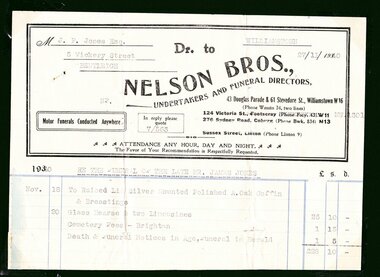
Certificate - Documents, Funeral James Jones 1940, c1940
James Jones was the son of Philip Jones, a Chairmaker, and Ann Jones who settled in East Brighton after the sale of land c1852 in the area of the Henry Dendy Special Survey of 1841. Mary Ann Moore was the daughter of Thomas Moore, a Gardener, and Sarah Harris who also settled in Brighton c1852. James and Mary Ann Jones settled and raised their family in East Brighton now Bentleigh. Mr John Herron resided at 4 Vickery St Bentleigh until 1989. Sadly Martha Jones born 1888 died in 1890 and James Jones had to purchase a plot at Brighton General Cemetery for her burial. Baby Ethel May was interred in 1893 and then Mary Ann in 1903 and finally James in 1940. Their stillborn baby was buried in the Wesleyan public grave in 1900James Jones and Mary Ann Moore were born in Brighton c1857 and c 1859 into pioneer market gardener families in the area of the Dendy Special Survey of 1841. They married in 1883 and raised their family in East Brighton, now Bentleigh. Sadly infectious diseases took the lives of many infants throughout the Colony of Victoria due to the poor state of water supply and sewerage disposal and locally the swamps of the Elster Creek were a constant breeding ground. Martha Jones born 1888 died 1890 and was interred in the Brighton General Cemetery in a family plot, in the Wesleyan Section, purchased by her father James Jones. In 1893 another daughter Ethel May died and was buried in the family plot. A stillborn baby was interred in the public grave of Brighton General Cemetery in May1900. Mary Ann Jones died, at age 43years, and was interred in January 1903. Finally in November 1940 Mr James Jones was buried in the family grave. 1 original paper account and 1 paper receipt from Nelson Bros. Funeral Directors re the funeral of James Jones in November 19401) M..J.P Jones Esq./ 5 Vickery Street/ Bentleigh / WILLIAMSTOWN/ 27/11/1940 Dr to / NELSON BROS.,/UNDERTAKERS AND FUNERAL DIRECTORS, / 43 Douglas Parade & 51 Stevedore St., Williamstown W16 / Motor Funerals Conducted Anywhere / In reply please quote 7/563/ Re The Funeral of The Late MR. JAMES JONES/ £28:10:0 -1 Glass Hearse & 2 Limousines, Cemetery Fees and Newspaper notices 2) As above / 27/111940 / A Memo. from NELSON BROS.,/ Dear Sir, /Herewith ...our official receipt... / signed A Nelson / Manager* wesleyan church, brighton general cemetery, vaccination, pioneers, early settlers, typhoid, brighton, moorabbin, bentleigh, market gardeners, jones james, jones mary ann, jones martha, dendy henry, dendys special survey 1841, infectious diseases, water supply, elster creek, melbourne, orford g h, printers, southern cross office, “brighton leader” print, bay street brighton, jones ethel may -
 City of Moorabbin Historical Society (Operating the Box Cottage Museum)
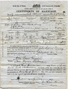
Document - Wedding Certificate, Elizabeth Jones, c1917
James Jones was the son of Philip Jones, a Chairmaker, and Ann Jones who settled in East Brighton after the sale of land c1852 in the area of the Henry Dendy Special Survey of 1841. Mary Ann Moore was the daughter of Thomas Moore, a Gardener, and Sarah Harris who also settled in Brighton c1852. James and Mary Ann Jones settled and raised their family in East Brighton now Bentleigh. They sadly lost Martha Jones born 1888 died in 1890 ,and. Baby Ethel May died 1893 and a stillborn baby was buried in 1900. However, their daughter Elizabeth Ann Jones born 1885 married John Patrick Kennedy born 1885, a the son of Thomas Kennedy , Dairyman deceased, and Jane Donovan early settlers in the Brighton area, at South Melbourne in January 1917 . James Jones and Mary Ann Moore were born in Brighton c1857 and c 1859 into pioneer market gardener families in the area of the Dendy Special Survey of 1841. They married in 1883 and raised their family in East Brighton, now Bentleigh. Sadly infectious diseases took the lives of many infants throughout the Colony of Victoria due to the poor state of water supply and sewerage disposal and locally the swamps of the Elster Creek were a constant breeding ground. Martha Jones born 1888 died 1890 and was interred in the Brighton General Cemetery. In 1893 another daughter Ethel May died and stillborn baby in May1900. Mary Ann Jones died, at age 43years, in January 1903 and in November 1940 Mr James Jones was buried in the family grave. Their daughter Elizabeth Ann Jones , born 1885, married John Patrick Kennedy, born 1885, the son of Thomas Kennedy, a dairyman and Jane Donovan also early settlers in Brighton area at St Luke’s Anglican Church in South Melbourne in January 1917 Original Certificate of Marriage of Elizabeth Ann Jones, the daughter of James and Mary Ann Jones, to John Patrick Kennedy at St Luke's Anglican Church in South Melbourne on January 1st 1917In the State of Victoria/ crest/ In the Commonwealth of Australia/FOURTH SCHEDULE ACTSNOS. 2691 and 2720 -FORM B/ CERTIFICATE OF MARRIAGE B/ Year 1917Parish or Church District South Melbourne Denomination Church of England/ signed by Patrick Kennedy and Elizabeth Jones, witnesses Ada Hewton and Alice Steedman and Vicar David Ross Hewton dated this first day of January 1917anglican church, st luke's south melbourne, jones elizabeth ann, kennedy john patrick, kennedy thomas, donovan jane, dairyman, dairy farms, brighton general cemetery, vaccination, pioneers, early settlers, typhoid, brighton, moorabbin, bentleigh, market gardeners, jones james, jones mary ann, jones martha, dendy henry, dendys special survey 1841, infectious diseases, water supply, elster creek, melbourne, jones ethel may, reverend hewton david ross -
 City of Moorabbin Historical Society (Operating the Box Cottage Museum)
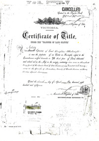
Document - Photocopy of Land Title 1881, c1881
This is a Certificate of Title for an acre of land in 'Tucker's Road' purchased by Jabez Gurr in 1881, in the area that was part of the Crown Block known as Henry Dendy's Special Survey 1841, in the Parish of Moorabbin, County of Bourke, Victoria. Following the 'Transfer of Land Statute' allotments in the area of Henry Dendy's Special Survey of 1841 were sold to early settlers. This Certificate of Title shows the passage of history in Moorabbin Shire . Jabez Gurr, a wheelwright, of East Brighton, now Bentleigh East, purchased an acre of land in 'Tucker's Road' , near Centre Road, in 1881. In 1889 he sold to a produce merchant, Robert Smith, and in April 1916 this block was purchased by William Henry George Box, a market gardener and relative of William and Elizabeth Box, who owned the land until 1926. The land was then purchased by Charles John Greenlaw Coates and remained with this family until 1971. All these Family names appear on Councils and Community Boards during the foundation and development of City of Moorabbin3 photocopied pages of the Certificate of Title for approximately 1 acre of land near the corner of Centre Road and Tucker Road, Parish of Moorabbin, County of Bourke, Victoria that was part of the 5,120 acre Henry Dendy Special Survey in Brighton in 1841 and purchased in 1881 by Jabez Gurr. It records subsequent proprietors up to 1971Stamped CANCELLED 12 OCT 1994 (top Right) / Entered in the Register Book / Vol.1245 Fol. 248877/ signed Henry Crowe / Assistant Registrar of Titles / Coat of Arms / VICTORIA / Certificate of Title / UNDER THE ' TRANSFER OF AND STATUTE' /dated ' eleventh day of April one thousand eight / hundred and eighty one' / signed 'Henry Crowe' / Assistant Registrar of Titles/ ENCUMBRANCES REFERRED TO / circular Stamp 'OFFICE OF TITLES VICTORIA' / Drawn and shaded on the left side is the area of land in "Tucker's" Road 3331/3 links fro Centre Road, 150 links x 6662/3 links / The measurements are in linksdendy henry, dendy's special survey 1841, brighton, moorabbin, bentleigh, market gardeners, early settlers, pioneers, wheelwrights, merchants, fruit gardens, markets, smith robert, box william henry george, gurr jabez, county of bourke, victoria, melbourne, land statutes, tucker road, centre road, box william, box elizabeth, box cottage museum -
 City of Moorabbin Historical Society (Operating the Box Cottage Museum)
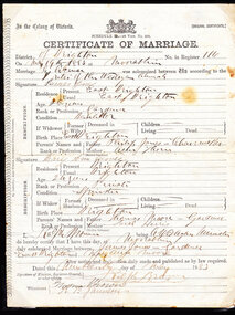
Certificate - Marriage Certificate, James Jones, c1880
James Jones was the son of Philip Jones, a Chairmaker, and Ann Jones who settled in East Brighton after the sale of land c1852 in the area of the Henry Dendy Special Survey of 1841. Mary Ann Moore was the daughter of Thomas Moore, a Gardener, and Sarah Harris who also settled in Brighton c1852. James and Mary Ann Jones settled and raised their family in East Brighton now Bentleigh. Mr John Herron resided at 4 Vickery St Bentleigh until 1989. James Jones and Mary Ann Moore were born in Brighton c1857 and c 1859 into pioneer market gardener families in the area of the Dendy Special Survey of 1841. They Married in 1883 and raised their family in East Brighton now known as BentleighThe original Certificate of Marriage of James Jones and Mary Ann Moore at the Wesleyan Church, Moorabbin on May 19th 1883In the Colony of Victoria / - Coat of Arms- / ( ORIGINAL CERTIFICATE) / Schedule D,-28 Vict. No. 268 / CERTIFICATE OF MARRIAGE / District of Brighton/ with date and signatures of participants. wesleyan church, pioneers, market gardeners, brighton, moorabbin, dendy’s special survey, wedding certificates, jones james, moore mary ann, browne ralph, rites -
 City of Moorabbin Historical Society (Operating the Box Cottage Museum)
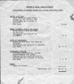
Document - Document, statement of fees 1950, c1950
Mr John Herron and his wife Isa Mary Herron purchased the house at 4 Vickery Street Bentleigh in 1950 from Miss M Marriott. He was a descendant of John James an early settler dairyman in Moorabbin Shire and Miss M Marriott was a descendant of the early settler market gardeners Marriott family. Mr Herron lived there until 1989 and the house was then demolished and turned into a carpark for the busy Shopping precinct of Centre Road, Bentleigh.The Marriott family were early settler market gardeners from 1878 in the area of Dendy’s 1841 Special Survey and John Herron was a descendant of Philip Jones , a chair-maker, who settled in the area of East Brighton, now Bentleigh, in 1852 An original, paper, Statement of Adjustments attached to previous item 00053.3 for purchase of the house at 4 Vickery Street, Bentleigh by Mr John Herron from Miss M Marriott in 1950 Heading - HERRON & ANOR. From MARRIOTT / Adjustment of Rates, Taxes, etc., as at 12th May 1950 / list of costs/ typed in left hand bottom corner – E. & O.E, / Melbourne, / 10th May 1950 pioneers, early settlers, brighton, moorabbin, bentleigh, market gardeners, dairyman, dairy farmer, jones james, jones mary ann, jones martha, jones elizabeth ann, dendy henry, dendys special survey 1841, elster creek, melbourne, jones ethel may, herron isa mary, herron john, tram conductor, marriott m, boothby b b, boothby n b, solicitors, land sales, house sales 1950, real estate