Showing 1208 items
matching late 1960s
-
 Melton City Libraries
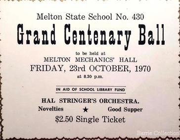
Document, Grand Centenary Ball Ticket, 1970
... from the UK, from the late 1960s. This presaged the boom... from the UK, from the late 1960s. This presaged the boom ...History of the Place "On 17th May 1858 a State subsidised, combined Denominational School was opened by HT Stokes, with an attendance of about 30 children. This school was conducted in the wooden Melton Combined Protestant Church, situated on ‘a creek flat’ thought to be on the north side of Sherwin Street between Pyke and Byran Streets. It is likely that the Church had been established by 1855 and that the first minister was the Rev. Hampshire, who lived in Cambridge House on the Exford Estate. Ministers of the Protestant denominations were invited to hold services there. As there was only one resident Minister in the town (Presbyterian Mr J Lambie), laymen of the various denominations often spoke on Sundays. In 1863 this building was declared a Common School with the number 430. One of its first and most prominent headmasters was John Corr, who served from 1860 to 1864. Most of Mr Corr’s children also became teachers, including Joseph Corr, at the Rockbank school, and J Reford Corr and WS Corr, headmasters and teachers at numerous prestigious private secondary schools around Australia. John Corr purchased land alongside the school and elsewhere in and near Melton, became secretary and treasurer of the new Cemetery Trust, and by July 1861 was deputy registrar of births, deaths and marriages. He walked three miles every Sunday to teach at the Weslyan Sunday School he had established. Despite good reports from the Education Department Inspector, and burgeoning enrolments, the local school committee recommended the dismissal of, firstly, his wife (from the work mistress position), and then him from the headmaster position. Corr saw his dismissal as an attempt to redirect state aid for education from the Combined Protestant school to the support of the Free Presbyterian Minister Rev James Lambie (by one account the owner of the land on which the Common School was erected), whose son-in-law James Scott subsequently assumed responsibility for the school. Rev Lambie failed in his efforts to keep the existing school, which the Education Department Inspector and the majority of Melton citizens regarded as badly situated and badly built. Following a conditional promise of state aid, local contributors in 1868-69 raised ₤72.10.6 towards the cost of an iron-roofed bluestone rubble building 43 ft x 12 ft. This was erected on a new site of 1.5 acres (the present site). The State contributed ₤120 to the new school, which opened in 1870. A very early (c.1874) photograph of the school shows its headmaster and work mistress / assistant teacher (probably James Scott and his wife Jessie) and its (very young) scholars. Similar photos show pupils in front of the school in c.1903, and 1933. In 1877 a second bluestone room costing ₤297 was added and further land acquired from the Agricultural Society (who only needed it two days a year) to enlarge the schoolground to 3 acres. In the early 1880s an underground tank augmented the school water supply and in 1919 a five-roomed wooden residence was added. During this period the school correspondents often compained that the walls of the bluestone buildings were damp, affecting the plaster. In 1923 a brick room 26 ft 6 in by 24 ft with a fireplace and four rooms facing south, was added, and a corridor built to link the three buildings. This served adequately for the next 40 years. The school bell probably dates to 1883. The school also has a memorial gate (1951) to World War One ex-students, and an honour board to the 64 ex-students who served in the First World War. The school roll fell to 42 in the early post war-years, but was boosted by an influx of migrants, mainly from the UK, from the late 1960s. This presaged the boom in Melton’s development, and the corresponding growth of the school, with timber and temporary classrooms added to the previous masonry ones. An endowment pine plantation established in 1930 augmented the school’s fundraising activities when it was harvested in 1968. Part of the site was planted with eucalyptus trees in 1959. Famous ex-students of the early twentieth century included Hector Fraser (internationally successful shooter) and cyclist Sir Hubert Opperman". Ticket for the Grand Centenary Ball at Melton State School 430education, local significant events -
 Eltham District Historical Society Inc
Photograph - Digital Photograph, Alan King, Maroondah Aqueduct Siphon Bridge over the Plenty River, 26 January 2008
... sections were replaced with large pipes. In the late 1960s a large... sections were replaced with large pipes. In the late 1960s a large ...Opened in 1891, the bridge formed part of the Maroondah Aqueduct carrying water from Watts River near Healesville to the reservoir at Preston where it joined Melbourne's metropolitan water system. Covered under Heritage Overlay, Nillumbik Planning Scheme. Published: Nillumbik Now and Then / Marguerite Marshall 2008; photographs Alan King with Marguerite Marshall.; p99 Built to supply thirsty Melbourne in the late 19th century, the siphon bridge spanning the Plenty River off Leischa Court, Greensborough, was part of an engineering masterpiece. Opened in 1891, the bridge formed part of the Maroondah Aqueduct carrying water from the Watts River near Healesville to the reservoir at Preston where it joined the metropolitan distribution system. A major link in Melbourne’s water supply, it also had a huge impact on communities, which mushroomed along its route. Named after the Aboriginal word for the area around the Maroondah Reservoir, the Maroondah Aqueduct was fully operational until the 1970s. Since the 1980s the land along parts of the aqueduct have been used for walking and bicycle riding, shaded in places by Monterey Pine trees planted to stabilise the surrounding ground. From 1857 the Yan Yean Reservoir supplied Melbourne’s water but the growing city needed additional catchments.1 In 1886 work began on a weir on the Watts River to enable the aqueduct to carry most of the river water 41 miles (66km) to Melbourne. The aqueduct, built by the Board of Works, is the oldest remaining aqueduct near Melbourne and was probably the first built with concrete.2 Although the aqueduct is now only used between the Maroondah and Sugarloaf Reservoirs, it can still be traced across the Shire. It extends from the Maroondah Reservoir through Christmas Hills, Kangaroo Ground, Research, Eltham, St Helena and then previously wound west through Greensborough to Reservoir.3 Built by horse and manpower the aqueduct gravity fed 25 million gallons (113.6ML) of water a day to Melbourne along a gradient of one foot to the mile. It included 25 miles (41km) of open concrete and brick channel, six miles (10km) of tunnels, and nine miles (15km) of 14 inverted siphons of riveted wrought-iron across creeks. Bricks for the aqueduct were made from clay found near the sites and remains of several kilns can still be found between Kangaroo Ground and Christmas Hills. Building the aqueduct transformed local communities. An abattoir was established at Christmas Hills. Grog shanties and labourers’ camps sprang up and local courts dealt with cases of ‘petty pilfering and boisterous behaviour’.4 The Kangaroo Ground school population jumped to 91, crammed into a room with one teacher. Miners who built the tunnels camped just north of Churinga in Greensborough – then called Tunnel Hill Camp – and adjacent to the Evelyn Arms Hotel. The miners’ high spirits were sometimes quenched in horse troughs or by a ‘welt under the ear and kick on the behind’ as the local constable calmed them down rather than lock them up.5 But the growing city of Melbourne needed more water, so the O’Shannassy catchment, east of Warburton, was added to the system in 1914. In 1920 work began on the present concrete Maroondah Dam one mile (1.6km) from the weir on the Watts River. The aqueduct capacity was thus doubled to 50 million gallons (227ML) a day.6 Intense land development threatened to pollute the open water supply, so channel sections were replaced with large pipes. In the late 1960s a large water main was built from the tunnel outlet at Research and extended through St Helena and Greensborough, so this section of the aqueduct was taken out of use. Long sections of the unused open channels in Greensborough and Bundoora were destroyed, but the old channel in Research and Eltham North remained largely intact. In the 1970s, the Sugarloaf Reservoir was constructed, inundating 445 hectares of land in Christmas Hills. Sugarloaf was officially opened in 1980 and serves as a water storage and treatment plant supplying Melbourne. In the early 1980s pipes replaced the section from Sugarloaf Reservoir to the tunnel entrance at Kangaroo Ground. The Research-Kangaroo Ground tunnel operates as part of the pipeline system.This collection of almost 130 photos about places and people within the Shire of Nillumbik, an urban and rural municipality in Melbourne's north, contributes to an understanding of the history of the Shire. Published in 2008 immediately prior to the Black Saturday bushfires of February 7, 2009, it documents sites that were impacted, and in some cases destroyed by the fires. It includes photographs taken especially for the publication, creating a unique time capsule representing the Shire in the early 21st century. It remains the most recent comprehenesive publication devoted to the Shire's history connecting local residents to the past. nillumbik now and then (marshall-king) collection, maroondah aqueduct, pipe bridge, siphon bridge -
 RMIT Design Archives
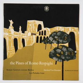
Record sleeve, The Pines of Rome - Respighi
... for the World Record Club in the late 1950s and early 1960s. Robinson’s... covers for the World Record Club in the late 1950s and early ...Max Robinson (1934-2018) designed this record sleeve for the World Record Club in 1961. Robinson studied for a year at the Melbourne Technical College (RMIT University), and in his early career worked for Peter Clemenger and the graphic designer, Max Forbes. He produced a number of striking record covers for the World Record Club in the late 1950s and early 1960s. Robinson’s work is familiar to many Australians – he designed the new $10 note in 1993, which featured Banjo Paterson and Dame Mary Gilmore. The World Record Club’s operated in Melbourne from 1957 until 1976; it was a mail order service, and its art director, Geoff Digby commissioned young designers and artist to design the record sleeves. It is regarded now as one of most representative collection of Australian designers’ work of its period, and highlights the years of transition from ‘commercial art’ to ‘graphic design’. The album cover was donated to the Archive by the World Record Club’s art director, Geoff Digby. Ann Carew, 2020This record sleeve is historically significant for its association with Max Robinson, who was inducted into the Australian Graphic Design Association’s (AGDA) Hall of Fame in recognition for his work as graphic artist, but also his tireless advocacy for graphic design in Australia. It is aesthetically significant as an early example of the design work of Max Robinson. It is historically significant for its association with the World Record Club, an organisation that produced a representative collection of Australian graphic designers’ work from 1957 until 1976. the Pines of Rome . Respighi / Roman Carnival overture . Berlioz / Herbert Von Karajan / the Philharmonia Orchestra / Les Preludes . Lisztworld record club, max robinson, rmit university, rmit design archives, geoff digby, record sleeve design, graphic design -
 Australian Gliding Museum
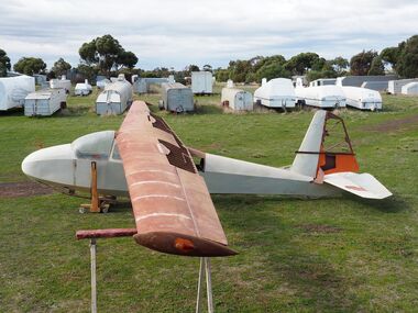
Machine - ES56 Nymph Sailplane
... by the Leichardt Soaring Club at Mount Isa in the (late?) 1960s... at Mount Isa in the (late?) 1960s. The history from ...ES 56 Nymph Following the successful introduction of the ES 52 Kookaburra two-seater in mid-1954, Edmund Schneider Ltd designed a higher performance single seat sailplane of similar construction and with similar handling qualities. It was designated the ES 56 and became known as the ES56 “Nymph”. The ES56 Nymph was a success in that it delivered the anticipated performance and was found to have satisfactory flying characteristics. However, only the prototype (“Nymph -I”) and three production examples (“Nymph-II”) were built. Schneiders made some changes to the design before building the production version. The wing chord at the tip on the prototype measured 650 mm. This was reduced to 500 mm for subsequent builds. The explanation is that provision was made in the original design for the possible lengthening of the tapered wing to 13 metres. However, apparently it was decided to retain the 11.900 metre span which allowed the tip chord to be reduced slightly. Other changes included the installation of scissor type air brakes in the wing instead of simple hinged flap spoilers and the addition of a landing wheel behind the skid on the fuselage. On one of the Nymph-II a dorsal was added on top of the fuselage forward of the vertical fin when repairs were made rectifying damage incurred as a result of an accident at Benalla on 31 March 1963. Even before these ES56 gliders were finished, Edmund Schneider Ltd decided to offer a less expensive single seat design to cater in particular for newly solo pilots, the ES57 Kingfisher. With the Kingfisher, Schneiders reverted to a traditional airfoil (Gott 549) for the wing instead of the laminar flow section that was chosen for the Nymph in the pursuit of performance. As such, the Kingfisher was more appropriately characterised as a single seat version of the Kookaburra in comparison to the Nymph. Schneiders continued for a time to offer the ES56 Nymph as a high-performance sailplane. However, its place in the market was soon overtaken by imported designs with superior performance, such as the Schleicher KA6, which Schneiders also imported and built under license. Nymph-I was test flown in December 1955 and entered by Harry Schneider into the gliding championships held at Waikerie from 5th to 16th of that month. Harry finished 12th in the individual placing out of a field of approximately 24. The capabilities of the Nymph were further demonstrated by Harry Schneider in January 1956 with a Gold C flight of 193 miles from Gawler in South Australia to Walpeup in Victoria. Nymph-I was acquired by the Port Pirie Gliding Club in South Australia. It has been saved and restored and is a regular feature at vintage glider rallies in Victoria and New South Wales. See Museum Newsletter No 35 Winter Edition 2017 pages 3 -6, for that story. The Nymph-II production models were delivered by Edmund Schneider Ltd in October 1956 to the Gliding Club of Victoria, the Victorian Motorless Flight Group and the Royal Australian Navy Gliding Association. The VMFG flew its Nymph in the First National Gliding Championships at Tocumwal, NSW, in December 1956 and all three were flown at the Second National Gliding Championships at Benalla in 29th December 1958 to 8th January 1959, delivering competitive performances based on handicap. Nymph-I Serial Number 17 Original owner – Port Pirie Gliding Club, S.A. Registered VH-GHG on 20 August 1957 Re-registered VH-GHA on 11 October 2016 Currently Raywood, Victoria Believed airworthy Nymph-II Serial Number 20 Original owner – R.A.N. Gliding Association Registered VH-GDX on 20 May 1957 Currently Locksley, Victoria. In storage Nymph-II Serial Number 21 Original owner – Gliding Club of Victoria Registered VH-GHU on 27 August 1957 Currently Bendick Murrell, N.S.W. In storage Nymph-II Serial Number 22 Original owner – Victorian Motorless Flight Group Registered VH-GFE on 5 March 1957 Currently Bacchus Marsh, Victoria Under restoration for display. The Museum’s exhibit is the ES56, serial number 22, registered as VH-GFE. The glider was flown by the VMFG in Victoria until approximately September 1968. GFA records show that it was transferred to Queensland in 1968, and it passed through several owners until the mid-1970s. Information received indicates that it was flown by the Leichardt Soaring Club at Mount Isa in the (late?) 1960s. The history from then is not presently known except to say that it has been kept in dry storage for many years. It is not known when the glider was last flown. What is Significant? The Schneider ES 56 Nymph single seat sailplane, serial number 22, designed and built in 1955-1956, by Edmund Schneider Ltd in Adelaide. It was delivered to its original owner, the Victorian Motorless Flight Group, in October 1956, and registered as VH-GFE on 5 March 1957. How it is Significant? The ES56 Nymph is of historical, aesthetic, scientific and research, and social significance to the Australian gliding community. Why it is Significant? The ES56 is of historical significance as it was designed and built by Edmund and Harry Schneider. The Schneiders immigrated to Australia after the end of the second world war bringing with them considerable expertise in relation to glider design and construction. Over the following decades they maintained a close association with the Gliding Federation of Australia and the gliding clubs and through their glider production made a major contribution to the sport. The ES56 is part of that story. The ES56 in its design and construction exhibits the glider construction technology of the time, which principally consisted of lightweight wooden framework skinned with ply and doped fabric. It exbibits design innovation, notably the use of a laminar flow wing profile in pursuit of better glide performance. Also, considerable attention was given to simplifying the structure in order to keeping cost and the weight low. The ES56 played a useful role at gliding clubs where it was operated, especially the late 1950s and early 1960s and is remembered well by pilots who flew her. The glider is in the course of restoration and provides an insight into the skills and workmanship that were involved in design, building and maintenance of these wooden aircraft. It is of aesthetic and scientific and research significance. Glider airframe of a traditional wood and fabric covered constructionNoneglider, sailplane, edmund schneider, harry schneider, es56, nymph, es57, kingfisher, victorian motorless flight group, gliding club of victoria, ran gliding association, port pirie gliding club, leichardt soaring club. -
 Ballarat Tramway Museum
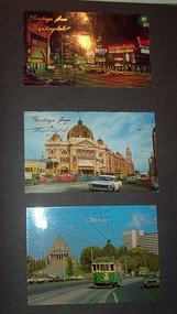
Album - Photo Album, Newstar, 1960s to 1970's
... Road and Nolan St., late 1960s - photograph. Princes Bridge...., late 1960s - photograph. Princes Bridge, looking over Yarra ...Photographic album containing 39 Colour postcards of Melbourne trams. The album consists of 30 leaves of dark grey heavy paper with three creases on left hand side of sheet, bound into a heavy bluey grey folder, embossed in gold 'Scrap Book" and bound with bluey grey string with two holes. The cover has been embossed with a the blue grey in swirls. Inside of back cover is a white label, "A New Star Product", with a please ask for No. with "425" stamped on. Postcards have been glued into the album. Entries have been kept to a single line - cards are able to be dated from buildings, whether the trams have marker lights, types of motor cars and general Melbourne history. Image files in page number order. Image 15 is of book. All taken with a electronic camera. Page 1 - Night photo - Flinders and Swanston St. - with "Greetings from Huntingdale" embossed in gold. Flinders St. station, with "Greetings from Huntingdale" embossed in gold. (post 1972 ) St. Kilda road with the Shrine of Remembrance in the background and W2 453 inbound on route 6. (post 1974) Page 2 - Bourke St, looking from Parliament House westwards, with Z8 inbound - after 13/8/1975 on route 89. Bourke St, looking east from Queen St., night photo, early 1970's. Princes Bridge looking towards Flinders St. Station Page 3 - Flinders St. Station, from Princes Gate buildings, - Photo E. Ludwig, John Hinde Studios. Bourke St. from Queen St, looking east, late 1960's - all W's. - W7 1026 east bound on route 88. Flinders St and Swanston St. corner, from Princes Bridge - night photo - W5 756 northbound route 15. Page 4 - W2 584 inbound route 64, St. Kilda Road and Nolan St., late 1960s - photograph. Princes Bridge, looking over Yarra River to the east. (pre Concert Hall) St. Kilda Road, with Shine of Remembrance in background, W2 303 inbound route 4D, mid 1960's. Page 5 - Flinders and Swanston St, W2 530 outbound route 8, early 1970's. Swanston and Collins St., W2 596 westbound in Collins St. City Square built - 1st version. (post 1972) St Kilda Road, with Shine in background, W2 298 and others, route 8 and 72. (post 1972) Page 6 - Flinders and Swanston St., W2, inbound route 5 on a wet evening. (mid 1970's) W2 515 outbound, Collins St., late 1960's, with Town Hall in background. (early 1970's, prior to lights) Collins St. looking west at Russell St with W2 637outbound route 42, early 1960's. Page 7 - Swanston St looking south at Little Bourke, W2's 373 route 67 and 374?(route 5), southbound, early 1970's Flinders St. Station, looking west in Flinders St., early 1970's, at dusk. Melbourne Town Hall with City Square from the North West (early 1970's) Page 8 - Bourke St looking east from Queen St. with W7 1005 inbound on route 96 - early 1970's. Bourke St. looking west from Exhibition St. with W6 976 outbound on route 95 - early 1970's. Swanston St. looking south from Lonsdale, with W2 484 on route 64, W2 228 and W2 364 in photo - early 1970's. Page 9 - Swanston looking south from north of Lonsdale St with many tramcars in photo - mid 1970's. St Kilda Road, with Shrine in background, W2 345 outbound route 4, SW6 913 inbound route 4 - prior to 1970. St Kilda Road, with Shrine in background, with trams in photo - early 1970's. (Photo loose in album - National View postcard by Murfett Ltd. Aust.) Page 10 - Postcard - TMSV? of 1041 and cable car set at Preston Workshops. 1041 in Bourke St., looking east from Queen St. - early 1970's - 1974? Collins St. looking east from Elizabeth St. with W2 253 inbound route 11, and W2 224 outbound - rout 47, early 1970's Page 11 - TMSV Postcard, X217 in Dandenong Road with L class in background. Shrine of Remberance from BP building, looking towards the city with St. Kilda Road on the left. Princes Gate and Flinders St. from the SEC buildings in Flinders St. looking south east - mid 1960's. Page 12 - Swanston St. at Flinders St. looking north at dusk. Flinders St. station at Swanston St with trams crossing at intersection - late 1960's Flinders St. station with W2 327 outbound. Page 13 - Temporary City Square at Collins and Swanston St. with tramcars at intersection. Wellington Parade (Mugs Alley), looking towards the City, with W2 546 inbound on route 38 - mid to late 1960's. Page 14 - Swanston St. looking south, at Lonsdale St, W2 432 inbound route 7 - late 1960's or early 1970's. Partly loose in album - National View postcard by Murfett Ltd. Aust. trams, tramways, photo album, melbourne, postcards -
 The Beechworth Burke Museum
Photograph, 1960s
... exploded during this post-war period of the late 1950s and 1960s... exploded during this post-war period of the late 1950s and 1960s ...This photograph was taken in the 1960s at Lake Sambell Caravan Park and visible in the photograph are individual caravan sites with electricity outlets, a large single-story building with a caravan park banner, dirt roads, a freestanding message board, and a parked car. Lake Sambell Caravan Park opened in 1959 owing to the work of R.E. Carter, Beechworth Shire engineer from 1954-63. Carter advocated for improvements to the lake and surrounding area in order to encourage tourism in Beechworth. The opening of the caravan park was part of many improvements to Lake Sambell made in this period by Carter including: the swimming pool in 1961, water skiing and boating facilities, and increased lake surface in 1964. These improvements were financed mainly by grants from the Tourist Development Authority. The popularity of caravanning in Australia exploded during this post-war period of the late 1950s and 1960s. This popularity was driven by multiple factors, including: the stopping of fuel rations, the accessibility of car ownership through the manufacturing of affordable cars, technological developments in caravan design, and the increase in prosperity and leisure time for many Australians. Facilities such as electrical outlets to power caravans are present in this photograph of Lake Sambell Caravan Park. Lake Sambell is an artificial lake that was developed on the previous site of the Rocky Mountain Mining Company workings and was officially opened by Minister for Lands, Mr Baily, on October 5, 1928. The disused and unattractive remains of the mine were converted into a recreational area intended for swimming, boating, and fishing. The lake is named after Mr L.H. Sambell, shire engineer and secretary of the Forward Beechworth Committee, who advocated for the enhancement of Beechworth into a tourist destination and was central to the planning and establishment of the lake. This photograph is of historical and social significance in providing insight into caravanning during the 1960s in Australia. Caravanning was extremely popular during the 1960s in Australia due to multiple social and economic factors including the stopping of fuel rations, the accessibility of car ownership through the manufacturing of affordable cars, technological developments in caravan design, and the increase in prosperity and leisure time for many Australians.Black and white rectangle photograph printed on photographic paper and unmounted.Reverse: 3536/ [logo back printing: KODAK/ VELOX/ PAPER] / C798 lake sambell caravan park, lake sambell, caravanning 1960s, caravan park, rocky mountain mining company, kodak velox paper, r.e. carter, l.h. sambell, caravan electricity outlets, tourist development authority, post-war prosperity, forward beechworth committee, lake sambell boating, lake sambell swimming pool, lake sambell fishing, artificial lake, travel 1960s, recreation 1960s -
 The Beechworth Burke Museum
Photograph, 1960s
... exploded during this post-war period of the late 1950s and 1960s... exploded during this post-war period of the late 1950s and 1960s ...This photograph was taken in the 1960s at Lake Sambell Caravan Park, visible in the photograph are individual caravan sites with electricity outlets, a large single-story building, a parked car, and two caravans partially obstructed by trees. Lake Sambell Caravan Park opened in 1959 owing to the work of R.E. Carter, Beechworth Shire engineer from 1954-63. Carter advocated for improvements to the lake and surrounding area in order to encourage tourism in Beechworth. The opening of the caravan park was part of many improvements to Lake Sambell made in this period by Carter including: the swimming pool in 1961, water skiing and boating facilities, and increased lake surface in 1964. These improvements were financed mainly by grants from the Tourist Development Authority. The popularity of caravanning in Australia exploded during this post-war period of the late 1950s and 1960s. This popularity was driven by multiple factors, including: the stopping of fuel rations, the accessibility of car ownership through the manufacturing of affordable cars, technological developments in caravan design, and the increase in prosperity and leisure time for many Australians. Facilities such as electrical outlets to power caravans are present in this photograph of Lake Sambell Caravan Park. Lake Sambell is an artificial lake that was developed on the previous site of the Rocky Mountain Mining Company workings and was officially opened by Minister for Lands, Mr Baily, on October 5, 1928. The disused and unattractive remains of the mine were converted into a recreational area intended for swimming, boating, and fishing. The lake is named after Mr L.H. Sambell, shire engineer and secretary of the Forward Beechworth Committee, who advocated for the enhancement of Beechworth into a tourist destination and was central to the planning and establishment of the lake. This photograph is of historic and social significance in documenting the enhancement of the Lake Sambell area overseen by R.E. Carter and providing insight into caravanning during the 1960s in Australia. Caravanning was extremely popular in Australia during the late 1950s and 60s due to multiple social and economic factors including the stopping of fuel rations, the accessibility of car ownership through the manufacturing of affordable cars, technological developments in caravan design, and the increase in prosperity and leisure time for many Australians. Black and white rectangle photograph printed on photographic paper and unmounted.Reverse: 3538/ [logo back printing KODAK/ VELOX/ PAPER] / C798lake sambell caravan park, lake sambell, lake sambell 1960s, lake sambell fishing, lake sambell boating, lake sambell swimming pool, r.e. carter, l.h. sambell, tourist development authority, caravanning 1960s, caravan electricity outlets, caravan park, forward beechworth committee, rocky mountain mining company, lake caravan park, caravan mid 20th century, beechworth tourism, travel in the 1960s, holiday 1960s -
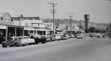 Wodonga & District Historical Society Inc
Photograph - High Street Wodonga in the 1950s
... This image shows High Street, Wodonga in the late 1950s... This image shows High Street, Wodonga in the late 1950s to early ...This image shows High Street, Wodonga in the late 1950s to early 1960s. The view is taken looking southwards towards the Water Tower at the end of the street. Businesses visible in the image include Currans Shoe Store, Greens Shoe Repair, a barber store, Pat's Ladies Hairdresser and Beauty Parlour, Albury Drycleaners, Jim Costello's, Bye's Butchery, Cafe, Astor Electrical goods and Victorian Producers. It is an enlargement of a Rose Series postcard. This photograph is representative of many images representing High Street, Wodonga as it developed over time. The Rose Series of postcards is a series of postcards of scenes from around Australia and some international ones as well. They were produced by the Rose Stereograph Company, which was the business of Victorian photographer George Rose (1861-1942). In 1880, George, aged 19, founded his business in Victoria, and soon became famous for producing stereographs, or stereo views. His early images included the landing at Anzac Cove, Ned and Dan Kelly’s Armour (taken at trial in 1880), The Duke & Duchess of York and their daughter Princess Elizabeth and Phar Lap winning the Melbourne Cup. When stereographs lost popularity during the 1920s, Rose switched to the production of postcards and decorative cards. He and his team of photographers took thousands of photos of scenery around Victoria and beyond, and the postcards became iconic images of Australian life. The Rose Stereograph Company Collection comprising more than 100,000 items was auctioned by Lloyds in June 2021. This image shows the main street of Wodonga and allows us to trace its development over time.A large photo printed on canvas. It shows High Street Wodonga in the late 1950s, looking southwards towards the water tower.high street wodonga, wodonga businesses, wodonga 1950s -
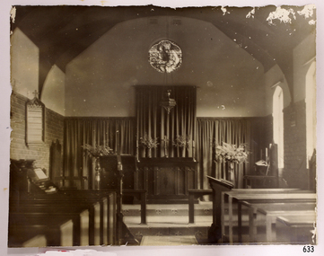 Flagstaff Hill Maritime Museum and Village
Photograph - Historical, religious, mid-20th century
... was undergoing multi-storey development in the late 1960s and early 1970s... was undergoing multi-storey development in the late 1960s and early 1970s ...This photograph records the interior of St Nicholas Seamen's Church at 139 Nicholson Street, Williamstown, Victoria, which was purchased and furnished around 1943. The furniture and furnishings are now part of the St. Nicholas Seamen's Church collection. HISTORY of the Missions to Seamen: - The Missions to Seamen is an Anglican (Church of England) charity that has been serving the seafarers of the world since 1856. It was inspired by the work of Rev. John Ashley, who, 20 years earlier, had pioneered a ministry to seafarers in the Bristol Channel in Great Britain. When Ashley retired, others continued the work, founding the Missions to Seamen. It adopted a Flying Angel as its symbol, inspired by a verse from the Bible in Revelation 14. Today, over 200 ports in the world have Missions to Seamen centres and chaplains. A Missions to Seamen’s club offers a warm welcome to sailors of all colours, creeds and races and provides a wide range of facilities. The Missions to Seamen organisation changed its name to the Mission to Seafarers in the year 2000 and continues, including Missions to Seamen clubs in Victoria’s cities of Melbourne, Portland, Geelong and Hastings. Flagstaff Hill’s St Nicholas’ Seamen’s Church is named after its namesake from Williamstown, Victoria, which began in 1857. Bishop Perry opened the first Sailors’ Church there, known as ‘Bethel’, on an old hulk floating in Hobson’s Bay, Port of Melbourne. In 1860, a Sailors’ Rest began operating from various rented premises at Williamstown. In 1878, the Sailors’ Church moved into an old Wesleyan chapel in Ann Street. By the end of that year, they were able to purchase the building, which they had already refurbished. In 1883, they affiliated with the Victorian Seamen’s Mission. A few years later, in 1906, the building had to be demolished as it was no longer safe. While they were raising funds for a new building, the Sailors’ Rest temporarily moved to a building in front of Customs House in Nelson Place. Around this time, in 1906, the Ladies Harbour Lights Guild was formed in Australia to support and raise funds for the Mission to Seamen organisation in Melbourne. Two of the most significant ladies of the Guild were founding members Ethel Godfrey and Alice Sibthorpe. During the Mission's time at Siddeley Street, Melbourne, the activities of the Guild raised funds for the Mission to Seamen's Chapel at their new, and still current, premises in Flinders Street, Melbourne, opened in 1917. The Guild continued its important work until the 1960s. In 1908, the Williamstown Mission had enough money to purchase the former Mascotte skating rink on Thompson Street, Williamstown. In August of that year, they were inaugurated into the Victorian Missions to Seamen. They continued at that venue for a few decades. In 1943, the former ES&A Bank building at 139 Nelson Place, Williamstown, was purchased to become the new Mission to Seaman’s Club. On May 6th, 1944, it was officially opened, described as a ‘distinctive little building’. Funds had previously been raised for the building and furnishing of the chapel at the rear. The chapel was named St Nicholas’ Seamen’s Church, after St Nicholas, fourth-century bishop and patron saint of sailors. Services were held on Wednesdays and Sundays. The church was supported by the Williamstown Lightkeepers’ Auxiliary, newly founded by Mrs Ethel Margaret Musther in 1943, as well as the Harbour Lights Guild and the League of Soldiers’ and Sailors’ Friends. The Williamstown Mission to Seamen’s Church operated until 1966, when the Port of Williamstown was no longer used by large international ships. The Commonwealth Government then leased the premises. In the formative years of Flagstaff Hill Maritime Village, the Advisory Board decided to include a Missions to Seamen Chapel and Recreation Room in its village. The Missions organisation was a significant feature of ports during the late 1800s and early 1900s, the period that the Village represents. They often erected Missions to house social and worshipful activities for seamen. Flagstaff Hill’s curator, Mr Ken Marshman, approached the Melbourne Board of Management of Missions to Seamen regarding the Williamstown branch. Consequently, the Board gave its permission for the entire furnishings of the Williamstown chapel to be transferred to Flagstaff Hill Maritime Village. A provision of the transfer was that the Victoria Missions to Seamen be recognised, that the items would remain as a collection, and that the chapel would be called St Nicholas Seamen’s Church and conduct Divine services. The donation was approved on 21st May 1979. Flagstaff Hill's St. Nicholas Seamen's Church: - The conception of Flagstaff Hill’s Missions to Seamen’s Church was partly motivated by the offer of Stained Glass Memorial Windows, originally from the local Warrnambool and District Base Hospital, which was undergoing multi-storey development in the late 1960s and early 1970s. The hospital’s Manager/Secretary was keen to see the historical window installed in an appropriate location. The church, or chapel, was designed by a local architectural draftsman in conjunction with the Flagstaff Hill Planning Board and was built by Mr Leon Habel. The designers had the hope that the church would be used for formal worship such as weddings, funerals and multi-denominational special services such as War commemorations. The design is based on the ‘Missions to Seamen’ buildings in both Portland and the Port of Melbourne. Placement of the furnishings was done as accurately as possible according to photographs of the Williamstown St Nicholas Seamen’s Church and with assistance from local clergy. The Recreation Room was furnished and arranged on advice from experienced members of the Missions to Seamen organisation. A framed document in the building recognises the donor of the furnishings, Victoria Missions to Seamen, as well as the names of some of the original donors and their donated item/s. The design of the building incorporates local features such as Warrnambool sandstone, which was no longer commercially available but was procured from demolished buildings and uniformly cut, to be used as a veneer over the stronger Mt. Gambier stone. Also, traditional green American roofing slate was used, sourced from the 1908 local shipwreck “Falls of Halladale” by Flagstaff Hill volunteer divers. The bell tower includes a bell believed to be from a local shipwreck. The additional furnishings were acquired locally, and several items were donated by Warrnambool residents. Light fittings in both rooms were assembled to simulate 19th-century gas light fittings. The stained-glass window at the back of the church is a memorial to Dr Connell, a well-respected member of the Warrnambool community. It was originally installed in 1928 in what was then the main building of Warrnambool Hospital. The St Nicholas’ Seamen’s Church at Flagstaff Hill was officially opened by His Worship the Mayor, Cr. John Lindsay, on Sunday 11th October 1981. The event included a service of thanksgiving conducted by the Warrnambool Ministers Fraternal. Since then, the Chapel has been the historic venue for many weddings.This item is significant through its association with the St Nicholas' Mission to Seamen Church in Williamstown, Melbourne, established in 1857.Photograph of St Nicholas Seamen's Church, Williamstown. Sepia photograph. The photograph shows the inside of the Chapel of Mission to Seamen, including organ, pews and other furniture and furnishings. There is a circular stained glass window high on the back wall depicting a sailor at the helm of a ship and a man standing behind him and pointing the way - "Christ Showing The Helmsman The Way". A Sanctuary Light is suspended from the ceiling. The Sanctuary chars are visible. This shows the St Nicholas Seamen's Church in Williamstown, the furnishings and furniture of which is now part of the St Nicholas Seamen's Church Collection’.flagstaff hill, warrnambool, shipwrecked-coast, flagstaff-hill, flagstaff-hill-maritime-museum, maritime-museum, shipwreck-coast, flagstaff-hill-maritime-village, st nicholas mission to seamen's church williamstown, mission to seamen williamstown, mission to seamen victoria, st nicholas mission to seamen, chapel window, christ showing the helmsman the way, stained glass window, st nicholas seamen's church, religion, religious service, sailor's rest, ladies harbour light guild -
 Albert Park-South Melbourne Rowing Club
Moore Sculling Machine
... in the 1960s. SMRC later donated it to APRC. • Bob Duncan remembers... in the 1960s. SMRC later donated it to APRC. • Bob Duncan remembers ..."Grace Blake’s conversations with older members of the Club have elicited the following information during July 2014: • Don Christie recalls the machine being acquired by (or donated to) SMRC in the 1960s. SMRC later donated it to APRC. • Bob Duncan remembers it being at APRC. • Max Shaw joined the club in 1946 but doesn’t recall it at all. • Peter Watson recalls collecting the rowing machine from the old APRC club house before its demolition (c. 1995). The AP-SMRC machine carries a ‘maker’s plate’ with the name Moore... Moore Crane and Engineering Company Pty Ltd was a subsidiary of Malcolm Moore Industries Ltd whose manufacturing engineering works were located on Williamstown Road, Port Melbourne from 1927. The founder established the main business in 1921 and retired in 1953.21 The business was delisted from the Australian Stock Exchange in 1976. Grace Blake advises that some of the earlier SMRC members were plumbers and therefore worked in trades connected with engineering. She reports that Peter Watson recalls some of his contemporaries completing their engineering apprenticeships at Malcolm Moore Industries Ltd in the 1970s. There are still many unanswered questions concerning the history and provenance of the rowing machine at the time of writing this report, but the connection with a local engineering works is certainly fascinating. Questions to explore in the future include: Did Moore manufacture the machine, or import it (and perhaps assemble it) under licence? Was this machine a ‘one-off’ or did Moore make / distribute others within Australia? When, why and how did SMRC acquire the machine? Why did SMRC decide not to retain it, but to pass it over to APRC? And how did APRC use it?" 2014 Significance Assessment, pp38-40. "The ‘Moore’ Rowing Machine at the Albert Park – South Melbourne Rowing Club (AP- SMRC) is a rare example in Australia of the Kerns patent design from 1900. This machine may not, however, be that old in construction or use. The AP-SMRC machine is almost intact, appearing to lack only the leather straps for fastening the rower’s feet to the foot-rests. Spalding manufactured the design in the USA in the early decades of the 20th century, but the metal elements in its models are traditionally black. The bright red paint on the AP-SMRC machine suggests something different. The AP-SMRC machine carries a maker’s plate that associates it directly with a local engineering business, Malcolm Moore Industries Ltd of Williamstown Road, Port Melbourne. Club members recall the machine being at the South Melbourne Rowing Club in the 1960s, and being transferred at a later date to the Albert Park Rowing Club. The machine has not been used since the founding of the amalgamated AP-SMRC and requires careful conservation. The ‘Moore’ rowing machine is of national research significance as a rare survivor, in Australia, of the well-regarded Kerns patent design that was popularised by Spalding in the northern hemisphere. The English River and Rowing Museum website quotes a testimonial from an AG Spalding & Bros’ Mail Order Catalogue: ‘This machine was described by ‘an experienced oarsman’ ... “to be the most perfect rowing machine ever produced”. A feature was the adjustment of the resistance so “the weaker sex can use the machine”’. Its historic significance lies in its rarity (and perhaps uniqueness) as an aid to the training of rowers at two successful clubs on Albert Park Lake. Additional historic significance lies in the connection that the rowing machine represents between local rowing clubs and a major local manufacturing engineer. The ‘Moore’ rowing machine bridges the realms of innovation and application, of industry and recreation, of land-based and aquatic sports, and of two neighbouring rowing clubs on the Albert Park Lake." 2014 Significance Assessment, p43"A rowing machine that appears to be built to the Kerns patent design from 1900 but may not be that old in construction or use. The machine is heavy and includes parts made from cast iron. The cast iron components are painted in a distinctive bright red. The wooden seat moves on timber slides. Resistance is created by spring mechanisms at the ends of two frame elements that connect with two wooden ‘oars’, and by the central chain-driven system that co-ordinates with the rower’s movements. The machine carries a maker’s plate with the single word ‘Moore’ in an oval design, using white letters against a navy background, fastened to the base board and close to the foot-rests." 2014 Significance Assessment, p38Moorerowing, apsm rowing club, significance assessment, malcolm moore industries ltd, kerns, 1900, sculling machine, albert park rowing club, south melbourne rowing club, albert park lake, rowing machine, ergo -
 Eltham District Historical Society Inc
Photograph - Digital Photograph, Alan King, Downing-Le Gallienne house, Yarra Braes Road, Eltham, 30 January 2008
... famous from the late 1940s to the 1960s. Covered under Heritage... famous from the late 1940s to the 1960s. Covered under Heritage ...The property is a classic example of what made Eltham famous from the late 1940s to the 1960s. Covered under Heritage Overlay, Nillumbik Planning Scheme. Published: Nillumbik Now and Then / Marguerite Marshall 2008; photographs Alan King with Marguerite Marshall.; p149 The first view of the large double-storey house at Yarra Braes Road, Eltham South, is of a jutting roofline over a balcony, reminiscent of a large sailing vessel or galleon – very appropriate, considering the name of one of the first owners, Le Gallienne. The Downing-Le Gallienne property is a classic example of what made Eltham famous from the late 1940s to the 1960s and attracted so many artists and intellectuals to the area. Set in a largely indigenous bush-style garden, the mud-brick and timber house was built by Alistair Knox. It was built for economist Richard Downing, to become a founder of the welfare state in Australia and Chairman of the Australian Broadcasting Commission, and musician and composer Dorian Le Gallienne. Le Gallienne was a pioneering composer of modern music in Victoria before 1945, whose works included the Symphony in E.1 He wrote several pieces of film music for Eltham Films, including The Prize, working with its writer and artistic director Tim Burstall. Le Gallienne was also a music critic for The Argus and later for The Age. In 1967 the music critic Roger Covell argued that Le Gallienne’s Symphony, was ‘still the most accomplished and purposive . . . written by an Australian’. According to Alan Marshall the main inspiration behind the building that evolved from 1948 to 1964 was Le Gallienne. ‘He was able to see value in the simplest things and many who worked there had their eyes opened for the first time to the Eltham environment, to the bush and the trees and the fauna which lived there.’ The garden included no formality, no lawns, nor exotic plants. ‘Natural informal growth came right up to their doors and so did the indigenous birdlife.’ This informal style – consisting of mass and void – was to be developed and popularised by landscaper Gordon Ford from the 1950s. The large mud-brick and timber house, which was built in four stages and has three separate but linked sections, began as a small weekend retreat for the couple. In 1948, Downing and Le Gallienne (Dick and Dor to their friends), asked Knox to build the 36 x18 foot (11mx5.4m) building with a pitched slate roof. It was built on a concrete slab and included a fireplace, which is still in use. The second wing was built in 1954 after Downing had returned from working at the International Labour Office and the couple decided to live there full-time. The third section was built after the death of Le Gallienne in 1963, aged 48. He is buried in the Eltham Cemetery. When Downing married widow, Jean Norman (nee McGregor) and had to accommodate a large family, including her six children and one of their own, the last stage was built by 1964. At that time the house was considered one of the largest mud-brick houses in Victoria. It consists of five living areas, including a small ballroom. Several artists helped Knox build the Downing-Le Gallienne house, which was one of his first of mud-brick. They included painter Clifton Pugh, artist John Howley and actor Wynn Roberts. Ellis Stones had landscaped the first wing and Gordon Ford set the boulder steps and made a pool as part of the landscaping he completed. Inside, the mud-bricks are largely whitewashed with pine-lined ceilings and Oregon beams. A winding timber staircase in the front extends behind a glass window from the ground floor to the top. The property, of a little more than 0.5 ha, is bordered by Parks Victoria land, which extends to the Yarra River.This collection of almost 130 photos about places and people within the Shire of Nillumbik, an urban and rural municipality in Melbourne's north, contributes to an understanding of the history of the Shire. Published in 2008 immediately prior to the Black Saturday bushfires of February 7, 2009, it documents sites that were impacted, and in some cases destroyed by the fires. It includes photographs taken especially for the publication, creating a unique time capsule representing the Shire in the early 21st century. It remains the most recent comprehenesive publication devoted to the Shire's history connecting local residents to the past. nillumbik now and then (marshall-king) collection, dorian le gallienne, downing-le gallienne house, eltham, mudbrick construction, mudbrick houses, richard downing, yarra braes road -
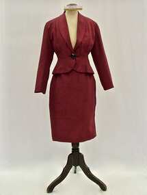 Brighton Historical Society
Suit, 1940s
... the late 1950s and early 1960s. Born in Riga, Latvia in 1923... a dance academy at 97 Bay Street during the late 1950s and early ...This suit was tailor-made for Latvian dancer, choreographer and dance teacher Vija Vetra, who lived at the Old Hall, 93-95 Bay Street, Brighton and ran a dance academy at 97 Bay Street during the late 1950s and early 1960s. Born in Riga, Latvia in 1923, at the age of sixteen Vija ran away from home in order to study classical, character and modern dance at the Vienna Academy of Music and Performing Arts. She spent several years performing on European stages. When Latvia was annexed by the Soviet Union in 1944, more than 100,000 Latvians fled, seeking refuge in neighbouring countries. Vija's sister, mother and aunt were among them, managing to join her in Vienna. The following year, all four had to flee again when the Soviets moved into Austria. Escaping to Bavaria, they spent three years in displaced person camps before emigrating to Sydney as refugees in 1948. Vija found success as a dancer in Sydney. She toured Australia and New Zealand with the Bodenwieser Ballet, formed a Latvian folk dancing group and established a dancing school. By the mid-1950s she had gained recognition as a recitalist in her own right. She developed a passion for Indian classical dance. In the late 1950s she moved to Victoria. She opened a dance school in Bay Street, Brighton, while continuing to perform on stage in productions such as the musical 'Kismet' and the ballet 'Corroboree'. In 1959 she starred in the four-part live ABC television program 'Music and Dance'. She left Australia in 1964 for a tour of the United States and Canada, ultimately settling in New York City. Interviewed in the 'ABC Weekly' in 1957, Vetra described her taste in clothing as minimalist, saying she preferred to own as few clothes as possible to save the trouble of deciding what to wear: "And no bows or extravagances, but always a simple line."Two-piece women's suit made of maroon corded silk; comprising fitted jacket (.1) and straight skirt (.2). Jacket fastens with one large black faceted glass button. Jacket lined with pink satin; skirt unlined. vija vetra, migration, brighton, refugee, dancer, 1940s -
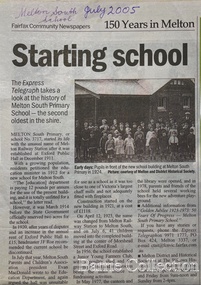 Melton City Libraries
Newspaper, Melton Schools-150 years in Melton, 2005
... from the UK, from the late 1960s. This presaged the boom... from the UK, from the late 1960s. This presaged the boom ...Melton South "The establishment of a settlement of Melton South was induced by the opening of the railway in 1884. This subsequently prompted a number of industries, initially sawmills, and in the early twentieth century, chaff mills. This development coincided with the Exford ‘Closer Settlement’ estate at the beginning of the new century, boosting local population and produce, and the development of the chaff industry which employed many people in the Melton area. (Around 1912 the government had brought out English migrants to settle the Exford estate.) By c.1912 the small Melton Railway Station settlement had a boarding house (probably for chaff or sawmill employees), store, a small church and a hall. The Melton Valley Golf Club originated near the railway station in 1927 (in 1931 it moved to the present Melton links). In 1910 the community had built the large timber ‘Victoria Hall’, which became the focus of community life for several generations. In August of that same year AR Robertson MP and D McDonald applied for the establishment of a school on land set aside for that purpose by the Closer Settlement Board, near the Melton Railway Station settlement. District Inspector McRae recommended that a school for classes up to Grade 3 be established as an adjunct to the Melton State School. And so SS3717, ‘Melton Railway School’, was established in the leased Victoria Hall on 1st December 1911. Thomas Lang, head master at Melton since 1896, was in charge of both schools. As a ‘prep’ school only, it was necessary that the older Melton Railway Station settlement students travel to Melton SS430 at Unitt Street. Since 1912 local residents had been petitioning for the establishment of a separate school at Melton Railway Station on the grounds that it would be better if all children from the one home could attend the same school, and that the Victoria Hall was unsuitable as a school building. As a result an area of 2 acres - Allotment 8, Parish of Djerriwarrh, Exford Estate - was reserved for a State School on 4th March 1914. However the Department wrote that a school would not be established there in the near future, as ‘there is no likelihood in sight that the Railway Station settlement will increase in importance’. Parents persisted with their petitions to the Education Department, claiming that the Victoria Hall was too large, had no fireplace, that teachers were unable to use the wall for teaching aids, and that, being less than 20 metres away from a chaff mill employing 30 men, was too noisy. The turning point came when in 1920 the Hall Committee decided to increase its rent for the hall. In 1920 Head Teacher Lang advised the Education Department to discontinue SS3717 as an adjunct. The District Inspector supported this recommendation, and the schools separated in 1923. In April of that year 41 children, comprising Grades 1-8, moved into an almost completed brick building on the present site. On the 6th July 1923 the official opening of the school took place; after a ceremonial journey from the Hall to the school, speeches were given by the Hon AR Robertson and the Chief Inspector of Education. Everyone then journeyed back to Victoria Hall for a ‘bountiful repast’. (These dates are at odds with the date of 5th March 1925 given in Blake as the date the children occupied the new SS3717 brick school building. ) A teacher’s residence had been purchased for ₤500 in 1923, and the school’s name was changed to ‘Melton South’ in the same year. Even though the older Melton South pupils would no longer have to travel to the Unitt Street school, an additional brick room was still required at the Melton SS430 in that same year. In 1961 a new room was added to the school. In 1972, at the beginning of Melton’s boom as a satellite town, the number of enrolments was 224. The school has since shared in the exponential growth of the town of Melton, and at the time of its jubilee celebration (1983), 524 pupils were enrolled. Victoria Hall, neglected and vandalised, was demolished in 1992. It had been handed back to the Council on condition that it be replaced by a new hall, with the same name, and was commemorated by a plaque. Apart from the 1923 brick school building, and the railway station, none of the principal early Melton South public sites survive. Few early residential sites remain. (Further research will establish whether the house on the corner of Station Street and the railway line was the original teacher’s residence.)" Melton State School "On 17th May 1858 a State subsidised, combined Denominational School was opened by HT Stokes, with an attendance of about 30 children. This school was conducted in the wooden Melton Combined Protestant Church, situated on ‘a creek flat’ thought to be on the north side of Sherwin Street between Pyke and Byran Streets. It is likely that the Church had been established by 1855 and that the first minister was the Rev. Hampshire, who lived in Cambridge House on the Exford Estate. Ministers of the Protestant denominations were invited to hold services there. As there was only one resident Minister in the town (Presbyterian Mr J Lambie), laymen of the various denominations often spoke on Sundays. In 1863 this building was declared a Common School with the number 430. One of its first and most prominent headmasters was John Corr, who served from 1860 to 1864. Most of Mr Corr’s children also became teachers, including Joseph Corr, at the Rockbank school, and J Reford Corr and WS Corr, headmasters and teachers at numerous prestigious private secondary schools around Australia. John Corr purchased land alongside the school and elsewhere in and near Melton, became secretary and treasurer of the new Cemetery Trust, and by July 1861 was deputy registrar of births, deaths and marriages. He walked three miles every Sunday to teach at the Weslyan Sunday School he had established. Despite good reports from the Education Department Inspector, and burgeoning enrolments, the local school committee recommended the dismissal of, firstly, his wife (from the work mistress position), and then him from the headmaster position. Corr saw his dismissal as an attempt to redirect state aid for education from the Combined Protestant school to the support of the Free Presbyterian Minister Rev James Lambie (by one account the owner of the land on which the Common School was erected), whose son-in-law James Scott subsequently assumed responsibility for the school. Rev Lambie failed in his efforts to keep the existing school, which the Education Department Inspector and the majority of Melton citizens regarded as badly situated and badly built. Following a conditional promise of state aid, local contributors in 1868-69 raised ₤72.10.6 towards the cost of an iron-roofed bluestone rubble building 43 ft x 12 ft. This was erected on a new site of 1.5 acres (the present site). The State contributed ₤120 to the new school, which opened in 1870. A very early (c.1874) photograph of the school shows its headmaster and work mistress / assistant teacher (probably James Scott and his wife Jessie) and its (very young) scholars. Similar photos show pupils in front of the school in c.1903, and 1933. In 1877 a second bluestone room costing ₤297 was added and further land acquired from the Agricultural Society (who only needed it two days a year) to enlarge the schoolground to 3 acres. In the early 1880s an underground tank augmented the school water supply and in 1919 a five-roomed wooden residence was added. During this period the school correspondents often compained that the walls of the bluestone buildings were damp, affecting the plaster. In 1923 a brick room 26 ft 6 in by 24 ft with a fireplace and four rooms facing south, was added, and a corridor built to link the three buildings. This served adequately for the next 40 years. The school bell probably dates to 1883. The school also has a memorial gate (1951) to World War One ex-students, and an honour board to the 64 ex-students who served in the First World War. The school roll fell to 42 in the early post war-years, but was boosted by an influx of migrants, mainly from the UK, from the late 1960s. This presaged the boom in Melton’s development, and the corresponding growth of the school, with timber and temporary classrooms added to the previous masonry ones. An endowment pine plantation established in 1930 augmented the school’s fundraising activities when it was harvested in 1968. Part of the site was planted with eucalyptus trees in 1959. Famous ex-students of the early twentieth century included Hector Fraser (internationally successful shooter) and cyclist Sir Hubert Opperman". The Express Telegraph articles about the history of Melton South and Melton State Schoolseducation -
 Eltham District Historical Society Inc
Negative - Photograph, Charles Bertie, Sketch; Sweeney's Cottage, Culla Hill, Eltham (n.d.), c.1905
... . At a later time (1960s), the Burstons (the then owners of Culla Hill.... At a later time (1960s), the Burstons (the then owners of Culla Hill ...In the early 1900s, Mary Sweeney commissioned artist Charles Bertie to paint the main house at Culla Hill. He charged her 5 shillings for the picture and 18 pence for the frame She took this painting with her when she married Michael Carrucan in 1910 and it hung in the Dalton Street farmhouse for many years. At a later time (1960s), the Burstons (the then owners of Culla Hill) had a card printed from the painting. The original sketch was photographed in 1970 for reproduction in the Shire history publication Pioneers & Painters (1971). The very fragile original was kept in the Council strongroom and suffered significant damage to its edges over the years, no doubt it has also yellowed. A comparison of the original as digitised (2022) with the negative taken 50 years earlier also reveals that the left 20% of the sketch has been cut off, probably due to damage. In June 1842 Thomas Sweeney applied to the Superintendent, C.J. La Trobe, asking permission to purchase a portion of the recently surveyed ‘Parish of Nillumbik'. His request was allowed and handed to the sub-treasurer and Land Board. He paid £110 for 110 acres and called the land 'Culla Hill'. He first built a temporary house, a slab hut 12 feet by 10 feet, in which he lived with his wife, an Irish girl whom he had married in 1838. (His first wife had been drowned at Port Jackson.) Some time later he built a permanent residence on the model of a Tipperary farmhouse. It was a rectangular building of hand-made bricks and stone quarried from the Western Hill with a recessed verandah in front, and bore a slate roof. The out-buildings consisted of a detached kitchen, stable and a barn. It was in this house that succeeding generations of Sweeneys were reared. The original slab hut became a washhouse and survived till recent years. 'Culla Hill' became a social centre for the district, church services being held there on various occasions. The first wheat crop in the district was planted by Sweeney who also supplied the first grain for a mill that later was built at Eltham. He took an active interest in the development of the district. At this time travelling people--many of them runaway sailors or convicts--often passed the settlement, and some of them stayed and worked with Sweeney. A tribe of aborigines living on the river below 'Culla Hill' were apparently on good terms with Sweeney, for it is said that they helped him with the building of his house. Very little is known about the aborigines who originally lived in the Eltham district. There must have been many of them; their stone axes, grinding stones, and anvil stones have been found in the gullies around Research and canoe trees and artifacts were found on the Kangaroo Ground hills. Early settlers remembered a tribe that camped on the site of the present railway bridge at Eltham. They held corroborees there and visited settlers for hand-outs of 'flour and bacca’. There was an aboriginal reserve on the Yarra, upstream from Eltham, but most of those who had collected there later went to live on the Pound Reserve at Warrandyte, where the last aborigines in the area finally ended their days. The Pound Reserve, of 1,103 acres, was established at Pound Bend in 1841. The chief protector, George Robinson, and his four assistants, were given instructions to care for the aged and sick, to provide blankets and rations for all who lived there, to train the able-bodied men in agriculture and other trades and to find them jobs. The Yarra blacks, who later came under the protection of William Thomas, have been described as a 'fine race, well made and above the average height'. Thomas Sweeney died on 6 September 1867 and was buried in the Eltham Cemetery. To his wife Margaret and his son John, he left the entire property of 'Culla Hill'. To his other son Patrick, he left 150 acres, including a small two-roomed wooden cottage. He had five daughters: Kate and Margaret (twins) who were born in 1842, Ellen 1846, Annie 1848 and Johanna 1851. John Sweeney farmed 'Culla Hill' until his death in 1909. He had ten children; one of them, Mary, became Mrs M. Carrucan whose son, Mr John Carrucan, still lives at Eltham. 'Culla Hill' passed out of the Sweeneys possession in 1939 and was renamed by its new owners, 'Sweeneys', in memory of its pioneers. - Pioneers & Painters: One Hundred Years of Eltham and its Shire, Alan Marshall 1971, pp10-12 Original colour sketch artwork 4 x 5 inch black and white negative of original colour sketchculla hill, art, charles bertie, drawing, mary carrucan (nee sweeney), sketches, sweeney's cottage -
 Eltham District Historical Society Inc
Photograph - Digital Photograph, Marguerite Marshall, Art Gallery at Clifton Pugh's Artists' Colony, Dunmoochin, Barreenong Road, Cottles Bridge, 5 February 2008
... another. But, in the late 1960s, the land was split into private... another. But, in the late 1960s, the land was split into private ...Art Gallery with mural painted by Clifton Pugh (1924-1990) at his Artists' Colony, Dunmoochin, Barreenong Road, Cottles Bridge. Following military service in the second world war, Clifton Pugh studied under artist Sir William Dargie at the National Gallery School in Melbourne as well as Justus Jorgensen, founder of Montsalvat. For a while he lived on the dole but also worked packing eggs for the Belot family saving sufficient to purchase six acres (2.4 ha) of land at Barreenong Road, Cottles Bridge. He accumulated more land and persuaded several other artists and friends to buy land nearby, resulting in a property of approximately 200 acres, stablishing it as one of the first artistic communes in Australia alongside Montsalvat in Eltham. It was around 1951 that Pugh felt he had '"done moochin' around" and so the name of the property evolved. He bought timber from Alistair Knox to build his house on the crest of a hill. Inspired by local goldminer's huts, it was a one room wattle-and-daub structure with dirt floor. Over the years it expanded with thick adobe walls made from local clay, high ceilings and stone floors. All materials other than the local earth were sourced from second hand materials, most found at wreckers' yards. Artists from across the nation were drawn to Dunmoochin, with several setting up houses and shacks on the property, maintaining their independence but sharing their artistic zeal. Artists who worked or resided at Dunmoochin included Mirka Mora, John Perceval, Albert Tucker, Fred Williams, Charles Blackman, Arthur Boyd and John Olsen. In 2002, Pugh's house along with its treasure trove of art and a library of some 20,000 books was destroyed by fire. Traces of Pugh's home remain with the presence of the Victorian doorframe archway with leadlight of intricate design, procured from a demolished Melbourne mansion; and two bronze life-sized female statues created by Pugh and cast by Matcham Skipper. In place of Pugh's house rose two double-storey mud-brick artists' studios topped with corrugated iron rooves curved like the wings of a bird with accommodation for seven. The original studios, gallery and other buildings survived the fire. Covered under Heritage Overlay, Nillumbik Planning Scheme. Published: Nillumbik Now and Then / Marguerite Marshall 2008; photographs Alan King with Marguerite Marshall.; p153 It’s not surprising that artist Clifton Pugh was drawn to Cottles Bridge to establish his artists’ colony Dunmoochin. Undisturbed by the clamour of modern life at Barreenong Road, Pugh was surrounded by the Australian bush he loved, and where his ashes were later scattered. The 200 acres (81ha) of bushland, broken by glimpses of rolling hills, has more than 50 species of orchids and Pugh shared his property with native animals including kangaroos, emus, phascogales, wombats, and diverse bird life. Pugh encouraged these creatures to join him in the bush by creating, with Monash University, a holding station where the animals were raised. Dunmoochin inspired Pugh for such paintings as in a book on orchids and the Death of a Wombat series.1 But his love for the bush was accompanied by the fear that Europeans were destroying it and much of his painting illustrated this fear and his plea for its conservation.2 However it was his house rather than the surrounding bush that was to be destroyed. Tragically in 2002 Pugh’s house, with its treasure of art and library of 20,000 art books, was destroyed by fire. Traces of the beauty of Pugh’s home still remain, however, in the magnificent Victorian doorframe archway with leadlight of intricate design procured from a demolished Melbourne mansion; and two bronze life-sized female statues created by Pugh and cast by Matcham Skipper. Now in place of Pugh’s house, are two double-storey mud-brick artists’ studios topped with corrugated roofs curved like birds’ wings, with accommodation for seven. The original studios, gallery and other buildings remain.3 Pugh grew up on his parents’ hobby farm at Briar Hill and attended the Briar Hill Primary School, then Eltham High School and later Ivanhoe Grammar. At 15 he became a copy boy for the Radio Times newspaper, then worked as a junior in a drafting office. Pugh was to have three wives and two sons. After serving in World War Two in New Guinea and Japan, Pugh studied under artist Sir William Dargie, at the National Gallery School in Melbourne.4 Another of his teachers was Justus Jörgensen, founder of Montsalvat the Eltham Artists’ Colony. Pugh lived on the dole for a while and paid for his first six acres (2.4ha) at Barreenong Road by working as an egg packer for the Belot family. Pugh accumulated more land and persuaded several other artists and friends to buy land nearby, resulting in the 200 acre property. They, too, purchased their land from the Belot family by working with their chickens. Around 1951 Pugh felt he had ‘Done moochin’ around’ and so the name of his property was born. Pugh bought some used timber from architect Alistair Knox to build his house on the crest of a hill. Inspired by local goldminers’ huts it was a one-room wattle-and-daub structure with a dirt floor. It was so small that the only room he could find for his telephone was on the fork of a tree nearby.5 Over the years the mud-brick house grew to 120 squares in the style now synonymous with Eltham. It had thick adobe walls (sun-dried bricks) made from local clay, high ceilings and stone floors with the entire structure made of second-hand materials – most found at wreckers’ yards. Pugh’s first major show in Melbourne in 1957, established him as a distinctive new painter, breaking away from the European tradition ‘yet not closely allied to any particular school of Australian painting’.6 Pugh became internationally known and was awarded the Order of Australia. He won the Archibald Prize for portraiture three times, although he preferred painting the bush and native animals. In 1990 not long before he died, Pugh was named the Australian War Memorial’s official artist at the 75th anniversary of the landing at Gallipoli. Today one of Pugh’s legacies is the Dunmoochin Foundation, which gives seven individual artists or couples and environmental researchers the chance to work in beautiful and peaceful surroundings, usually for a year. By November 2007, more than 80 people had taken part, and the first disabled artist had been chosen to reside in a new studio with disabled access.1 In 1989, not long before Pugh died in 1990 of a heart attack at age 65, he established the Foundation with La Trobe University and the Victorian Conservation Trust now the Trust for Nature. Pugh’s gift to the Australian people – of around 14 hectares of bushland and buildings and about 550 art works – is run by a voluntary board of directors, headed by one of his sons, Shane Pugh. La Trobe University in Victoria stores and curates the art collection and organises its exhibition around Australia.2 The Foundation aims to protect and foster the natural environment and to provide residences, studios and community art facilities at a minimal cost for artists and environmental researchers. They reside at the non-profit organisation for a year at minimal cost. The buildings, some decorated with murals painted by Pugh and including a gallery, were constructed by Pugh, family and friends, with recycled as well as new materials and mud-bricks. The Foundation is inspired by the tradition begun by the Dunmoochin Artists’ Cooperative which formed in the late 1950s as one of the first artistic communes in Australia. Members bought the land collaboratively and built the seven dwellings so that none could overlook another. But, in the late 1960s, the land was split into private land holdings, which ended the cooperative. Dunmoochin attracted visits from the famous artists of the day including guitarists John Williams and Segovia; singer and comedian Rolf Harris; comedian Barry Humphries; and artists Charles Blackman, Arthur Boyd and Mirka Mora. A potters’ community, started by Peter and Helen Laycock with Alma Shanahan, held monthly exhibitions in the 1960s, attracting local, interstate and international visitors – with up to 500 attending at a time.3 Most artists sold their properties and moved away. But two of the original artists remained into the new millennium as did relative newcomer Heja Chong who built on Pugh’s property (now owned by the Dunmoochin Foundation). In 1984 Chong brought the 1000-year-old Japanese Bizan pottery method to Dunmoochin. She helped build (with potters from all over Australia) the distinctive Bizan-style kiln, which fires pottery from eight to 14 days in pine timber, to produce the Bizan unglazed and simple subdued style. The kiln, which is rare in Australia, is very large with adjoining interconnected ovens of different sizes, providing different temperatures and firing conditions. Frank Werther, who befriended Pugh as a fellow student at the National Gallery Art School in Melbourne, built his house off Barreenong Road in 1954. Werther is a painter of the abstract and colourist style and taught art for about 30 years. Like so many in the post-war years in Eltham Shire, as it was called then, Werther built his home in stages using mud-brick and second-hand materials. The L-shaped house is single-storey but two-storey in parts with a corrugated-iron pitched roof. The waterhole used by the Werthers for their water supply is thought to be a former goldmining shaft.4 Alma Shanahan at Barreenong Road was the first to join Pugh around 1953. They also met at the National Gallery Art School and Shanahan at first visited each weekend to work, mainly making mud-bricks. She shared Pugh’s love for the bush, but when their love affair ended, she designed and built her own house a few hundred yards (metres) away. The mud-brick and timber residence, made in stages with local materials, is rectangular, single-storey with a corrugated-iron roof. As a potter, Shanahan did not originally qualify as an official Cooperative member.This collection of almost 130 photos about places and people within the Shire of Nillumbik, an urban and rural municipality in Melbourne's north, contributes to an understanding of the history of the Shire. Published in 2008 immediately prior to the Black Saturday bushfires of February 7, 2009, it documents sites that were impacted, and in some cases destroyed by the fires. It includes photographs taken especially for the publication, creating a unique time capsule representing the Shire in the early 21st century. It remains the most recent comprehenesive publication devoted to the Shire's history connecting local residents to the past. nillumbik now and then (marshall-king) collection, art gallery, clifton pugh, dunmoochin, cottlesbridge, cottles bridge, barreenong road -
 Eltham District Historical Society Inc
Photograph - Digital Photograph, Marguerite Marshall, Doorway of Clifton Pugh's former house at Dunmoochin, Barreenong Road, Cottles Bridge, 5 February 2008
... another. But, in the late 1960s, the land was split into private... another. But, in the late 1960s, the land was split into private ...Following military service in the second world war, Clifton Pugh studied under artist Sir William Dargie at the National Gallery School in Melbourne as well as Justus Jorgensen, founder of Montsalvat. For a while he lived on the dole but also worked packing eggs for the Belot family saving sufficient to purchase six acres (2.4 ha) of land at Barreenong Road, Cottles Bridge. He accumulated more land and persuaded several other artists and friends to buy land nearby, resulting in a property of approximately 200 acres, stablishing it as one of the first artistic communes in Australia alongside Montsalvat in Eltham. It was around 1951 that Pugh felt he had '"done moochin' around" and so the name of the property evolved. He bought timber from Alistair Knox to build his house on the crest of a hill. Inspired by local goldminer's huts, it was a one room wattle-and-daub structure with dirt floor. Over the years it expanded with thick adobe walls made from local clay, high ceilings and stone floors. All materials other than the local earth were sourced from second hand materials, most found at wreckers' yards. Artists from across the nation were drawn to Dunmoochin, with several setting up houses and shacks on the property, maintaining their independence but sharing their artistic zeal. Artists who worked or resided at Dunmoochin included Mirka Mora, John Perceval, Albert Tucker, Fred Williams, Charles Blackman, Arthur Boyd and John Olsen. In 2002, Pugh's house along with its treasure trove of art and a library of some 20,000 books was destroyed by fire. Traces of Pugh's home remain with the presence of the Victorian doorframe archway with leadlight of intricate design, procured from a demolished Melbourne mansion; and two bronze life-sized female statues created by Pugh and cast by Matcham Skipper. In place of Pugh's house rose two double-storey mud-brick artists' studios topped with corrugated iron rooves curved like the wings of a bird with accommodation for seven. The original studios, gallery and other buildings survived the fire. Covered under Heritage Overlay, Nillumbik Planning Scheme. Published: Nillumbik Now and Then / Marguerite Marshall 2008; photographs Alan King with Marguerite Marshall.; p155 It’s not surprising that artist Clifton Pugh was drawn to Cottles Bridge to establish his artists’ colony Dunmoochin. Undisturbed by the clamour of modern life at Barreenong Road, Pugh was surrounded by the Australian bush he loved, and where his ashes were later scattered. The 200 acres (81ha) of bushland, broken by glimpses of rolling hills, has more than 50 species of orchids and Pugh shared his property with native animals including kangaroos, emus, phascogales, wombats, and diverse bird life. Pugh encouraged these creatures to join him in the bush by creating, with Monash University, a holding station where the animals were raised. Dunmoochin inspired Pugh for such paintings as in a book on orchids and the Death of a Wombat series.1 But his love for the bush was accompanied by the fear that Europeans were destroying it and much of his painting illustrated this fear and his plea for its conservation.2 However it was his house rather than the surrounding bush that was to be destroyed. Tragically in 2002 Pugh’s house, with its treasure of art and library of 20,000 art books, was destroyed by fire. Traces of the beauty of Pugh’s home still remain, however, in the magnificent Victorian doorframe archway with leadlight of intricate design procured from a demolished Melbourne mansion; and two bronze life-sized female statues created by Pugh and cast by Matcham Skipper. Now in place of Pugh’s house, are two double-storey mud-brick artists’ studios topped with corrugated roofs curved like birds’ wings, with accommodation for seven. The original studios, gallery and other buildings remain.3 Pugh grew up on his parents’ hobby farm at Briar Hill and attended the Briar Hill Primary School, then Eltham High School and later Ivanhoe Grammar. At 15 he became a copy boy for the Radio Times newspaper, then worked as a junior in a drafting office. Pugh was to have three wives and two sons. After serving in World War Two in New Guinea and Japan, Pugh studied under artist Sir William Dargie, at the National Gallery School in Melbourne.4 Another of his teachers was Justus Jörgensen, founder of Montsalvat the Eltham Artists’ Colony. Pugh lived on the dole for a while and paid for his first six acres (2.4ha) at Barreenong Road by working as an egg packer for the Belot family. Pugh accumulated more land and persuaded several other artists and friends to buy land nearby, resulting in the 200 acre property. They, too, purchased their land from the Belot family by working with their chickens. Around 1951 Pugh felt he had ‘Done moochin’ around’ and so the name of his property was born. Pugh bought some used timber from architect Alistair Knox to build his house on the crest of a hill. Inspired by local goldminers’ huts it was a one-room wattle-and-daub structure with a dirt floor. It was so small that the only room he could find for his telephone was on the fork of a tree nearby.5 Over the years the mud-brick house grew to 120 squares in the style now synonymous with Eltham. It had thick adobe walls (sun-dried bricks) made from local clay, high ceilings and stone floors with the entire structure made of second-hand materials – most found at wreckers’ yards. Pugh’s first major show in Melbourne in 1957, established him as a distinctive new painter, breaking away from the European tradition ‘yet not closely allied to any particular school of Australian painting’.6 Pugh became internationally known and was awarded the Order of Australia. He won the Archibald Prize for portraiture three times, although he preferred painting the bush and native animals. In 1990 not long before he died, Pugh was named the Australian War Memorial’s official artist at the 75th anniversary of the landing at Gallipoli. Today one of Pugh’s legacies is the Dunmoochin Foundation, which gives seven individual artists or couples and environmental researchers the chance to work in beautiful and peaceful surroundings, usually for a year. By November 2007, more than 80 people had taken part, and the first disabled artist had been chosen to reside in a new studio with disabled access.1 In 1989, not long before Pugh died in 1990 of a heart attack at age 65, he established the Foundation with La Trobe University and the Victorian Conservation Trust now the Trust for Nature. Pugh’s gift to the Australian people – of around 14 hectares of bushland and buildings and about 550 art works – is run by a voluntary board of directors, headed by one of his sons, Shane Pugh. La Trobe University in Victoria stores and curates the art collection and organises its exhibition around Australia.2 The Foundation aims to protect and foster the natural environment and to provide residences, studios and community art facilities at a minimal cost for artists and environmental researchers. They reside at the non-profit organisation for a year at minimal cost. The buildings, some decorated with murals painted by Pugh and including a gallery, were constructed by Pugh, family and friends, with recycled as well as new materials and mud-bricks. The Foundation is inspired by the tradition begun by the Dunmoochin Artists’ Cooperative which formed in the late 1950s as one of the first artistic communes in Australia. Members bought the land collaboratively and built the seven dwellings so that none could overlook another. But, in the late 1960s, the land was split into private land holdings, which ended the cooperative. Dunmoochin attracted visits from the famous artists of the day including guitarists John Williams and Segovia; singer and comedian Rolf Harris; comedian Barry Humphries; and artists Charles Blackman, Arthur Boyd and Mirka Mora. A potters’ community, started by Peter and Helen Laycock with Alma Shanahan, held monthly exhibitions in the 1960s, attracting local, interstate and international visitors – with up to 500 attending at a time.3 Most artists sold their properties and moved away. But two of the original artists remained into the new millennium as did relative newcomer Heja Chong who built on Pugh’s property (now owned by the Dunmoochin Foundation). In 1984 Chong brought the 1000-year-old Japanese Bizan pottery method to Dunmoochin. She helped build (with potters from all over Australia) the distinctive Bizan-style kiln, which fires pottery from eight to 14 days in pine timber, to produce the Bizan unglazed and simple subdued style. The kiln, which is rare in Australia, is very large with adjoining interconnected ovens of different sizes, providing different temperatures and firing conditions. Frank Werther, who befriended Pugh as a fellow student at the National Gallery Art School in Melbourne, built his house off Barreenong Road in 1954. Werther is a painter of the abstract and colourist style and taught art for about 30 years. Like so many in the post-war years in Eltham Shire, as it was called then, Werther built his home in stages using mud-brick and second-hand materials. The L-shaped house is single-storey but two-storey in parts with a corrugated-iron pitched roof. The waterhole used by the Werthers for their water supply is thought to be a former goldmining shaft.4 Alma Shanahan at Barreenong Road was the first to join Pugh around 1953. They also met at the National Gallery Art School and Shanahan at first visited each weekend to work, mainly making mud-bricks. She shared Pugh’s love for the bush, but when their love affair ended, she designed and built her own house a few hundred yards (metres) away. The mud-brick and timber residence, made in stages with local materials, is rectangular, single-storey with a corrugated-iron roof. As a potter, Shanahan did not originally qualify as an official Cooperative member.This collection of almost 130 photos about places and people within the Shire of Nillumbik, an urban and rural municipality in Melbourne's north, contributes to an understanding of the history of the Shire. Published in 2008 immediately prior to the Black Saturday bushfires of February 7, 2009, it documents sites that were impacted, and in some cases destroyed by the fires. It includes photographs taken especially for the publication, creating a unique time capsule representing the Shire in the early 21st century. It remains the most recent comprehenesive publication devoted to the Shire's history connecting local residents to the past. nillumbik now and then (marshall-king) collection, art gallery, clifton pugh, dunmoochin, cottlesbridge, cottles bridge, barreenong road -
 Eltham District Historical Society Inc
Photograph - Digital Photograph, Marguerite Marshall, 'Landscape', 60 Lavender Park Road, Eltham South, 24 June 2008
... was then New Street but renamed Lavender Park Road in the late 1950s... was then New Street but renamed Lavender Park Road in the late 1950s ...Built by artist and cartoonist Percy Leason in 1927 in what was then New Street but renamed Lavender Park Road in the late 1950s/early 1960s. Covered under Heritage Overlay, Nillumbik Planning Scheme. Published: Nillumbik Now and Then / Marguerite Marshall 2008; photographs Alan King with Marguerite Marshall.; p121 Said to be a genius, cartoonist Percy Leason’s career was at its peak when in 1925 to 1926 he built his home at New Street (now Lavender Park Road) Eltham. The Herald newspaper owner, Sir Keith Murdoch, had hired Leason for his newly acquired Melbourne Punch magazine at a salary of £1750, making him ‘one of the highest paid cartoonists in the world’.1 With this salary and financial help from Murdoch, Leason was able to build his lovely home in Eltham. At the crest of a sweeping drive, the home now two-storey in white brick with a gabled grey slate roof and dormer windows is flanked by an extension built by another owner in the 1980s. Leason lived in the home with his wife, Isabel and children, until 1937, when he left for the United States of America, where he lived until his death in 1959. The four-bedroom house and garden would have been well-suited to bringing up his family and to entertaining their friends in style. Large airy rooms have high ceilings with moulded plaster, timber floors and several are brightened with bay windows. Leason made friends with many of the artists and personalities who gravitated to Eltham. Around 1931 Justus Jörgensen, founder of the Montsalvat Artists’ Colony, helped Leason build his large studio at the back of the house. Another friend was journalist Mervyn Skipper, father of jeweller and sculptor Matcham, and artists Helen and Sonia. Leason’s teacher, artist Max Meldrum, also visited and rented accommodation in Eltham, opposite Wingrove Park. Punch folded in 1925, but Leason continued as cartoonist for Table Talk. In 1926 Leason began the cartoons of a mythical Australian town Wiregrass, which were inspired by Kaniva, his home town. The art gallery in Main Road Eltham was named Wiregrass in Leason’s honour. Leason completed 1000 drawings from 1919 to 1937, which author Garrie Hutchinson claimed, were technically unsurpassed and had regional and universal interest. Leason’s acute observations of country life stemmed from his childhood in Kaniva in Victoria’s western Wimmera, where he was born, the son of a selector, in 1889. Meldrum claimed that Leason could name every plant and the habits of every animal.2 Leason also painted 28 portraits of the last full-blooded aboriginals in Victoria at Lake Tyers in Gippsland, most of which are in a private collection. In Sydney Leason illustrated Henry Lawson’s Selected Poems and worked for The Bulletin. Leason had begun his career at 13 as an apprentice lithographic artist at Sands and MacDougall. He attended night classes at the National Gallery and the Victorian Artists Society. Leason first visited Eltham in 1910 to paint with fellow artist William ‘Jock’ Frater. They camped near Bible and Pitt Streets and along the Diamond Creek on the site of the present Eltham Retirement Centre. Despite his success as a cartoonist, Leason wanted to be recognised as a serious painter and for his anthropological work.3 He was also conservative and felt uncomfortable with the modern art scene in Melbourne.4 So he left for the United States of America to work as a painter. Ironically his time in New York saw the burgeoning of modern art, notably by artists such as Jackson Pollock. But Leason found his niche by running an art school, painting society portraits and illustrating books and magazines.This collection of almost 130 photos about places and people within the Shire of Nillumbik, an urban and rural municipality in Melbourne's north, contributes to an understanding of the history of the Shire. Published in 2008 immediately prior to the Black Saturday bushfires of February 7, 2009, it documents sites that were impacted, and in some cases destroyed by the fires. It includes photographs taken especially for the publication, creating a unique time capsule representing the Shire in the early 21st century. It remains the most recent comprehenesive publication devoted to the Shire's history connecting local residents to the past. nillumbik now and then (marshall-king) collection, landscape, lavender park road, percy leason, new street -
 Eltham District Historical Society Inc
Photograph - Digital Photograph, Marguerite Marshall, Hawthorn hedges, Eltham-Yarra Glen Road, Kangaroo Ground, 3 October 2006
... for the increasing motor traffic. As late as the 1960s, corners were cut... for the increasing motor traffic. As late as the 1960s, corners were cut ...Hawthorn hedges are important reminders of Kangaroo Ground's Scottish heritage. They are Registered on the Victorian Heritage Register. They are "historically significant because the planting of hawthorn hedges reflects the adoption of Eurorpean farming techniques by the Kangaroo Ground population in the period following settlement and because the grid pattern of paddocks that the Hawthorn hedges define is very different to today's farm landscapes." Covered under Heritage Overlay, Nillumbik Planning Scheme. Published: Nillumbik Now and Then / Marguerite Marshall 2008; photographs Alan King with Marguerite Marshall.; p21 Hawthorn hedges bordering Kangaroo Ground’s gently rolling farmlands are important reminders of its Scottish heritage and are rare so close to Melbourne.1 As early as the 1840s newly arrived farmers from Scotland planted hawthorn hedges around their properties, to protect crops from the numerous kangaroos and wallabies. Many of these hedges survive today. These farmers had the good fortune to settle some of the most fertile land available for cropping in the Colony of Victoria. At that time the black volcanic soil could sustain an amazing two crops a year. By the mid 1850s, 500 acres (202ha) of wheat were growing in Kangaroo Ground. But the crops were threatened by kangaroos, which were so plentiful, that Surveyor-General, Robert Hoddle, named the district Kangaroo Ground in 1838. As post-and-rail fences proved inadequate barriers for the bounding kangaroos, the Scots planted hawthorn hedgerows as they had done in Scotland. Some also used the hedges to net birds, presumably for the table. Interestingly the farmers in the bordering townships of Panton Hill and Christmas Hills, did not plant hawthorn hedges around their properties. Perhaps it was because by the time they settled in the 1860s and 1870s most of the wildlife had been gunned down by residents.2 The canny Scots planted the hedges on public land outside their own farms, as the hedgerows could spread to about five yards (five m) in width. With this impenetrable barrier Kangaroo Ground’s industrious farmers flourished to gain the economic power that saw the Shire of Eltham governed from Kangaroo Ground for 79 years (1858-1937). The Scots jealously guarded their land, so hard to get in Scotland. That is why they refused to release any of it ‘for local roads to follow easier grades as was the case in surrounding districts where roads generally followed ridgelines or streams’.3 Instead the roads were built in accordance with the magnetic bearings of their first survey in 1847 whether that suited the steep topography or not. This could force traffic to diverge when wet through Greensborough and Diamond Creek. Until 1921, the Eltham-Yarra Glen Road beside Wellers Restaurant, ‘dipped down into the upper reaches of Stony Creek’.4 Later some corners were compulsorily cut for the increasing motor traffic. As late as the 1960s, corners were cut to form sweeping curves above and alongside the Kangaroo Ground Cemetery and opposite the Emergency Operations Centre. In the latter case, the farmers – understanding their hedgerows as important heritage – insisted upon their reinstatement to conform to the altered road alignment. Kangaroo Ground’s ancient manna gums also point to the district’s history and to that of the hedgerows. The Aboriginal people had transformed the original forests into grasslands with the fires they lit to attract kangaroos, (which the Scots were to exclude by planting hedgerows). But the Wurundjeri hunters left the gums (Eucalyptus vimminalis cygnetensis), on the grasslands as ‘stalking trees’ to hunt kangaroos. The hawthorn hedges in Kangaroo Ground were neglected for around 60 years from about the middle of the 20th century. Bushfires had created gaps and the hedgerows were not trimmed. Then in late 2005, local historian Mick Woiwod, formed a group to lobby the Nillumbik Shire to restore the hedges, which could last for many centuries. Some hedges in parts of Britain date back to AD 800.5 Although the original Scottish farmers have gone, the hedges are a reminder of when they flourished in the district, which has changed little in 150 years.This collection of almost 130 photos about places and people within the Shire of Nillumbik, an urban and rural municipality in Melbourne's north, contributes to an understanding of the history of the Shire. Published in 2008 immediately prior to the Black Saturday bushfires of February 7, 2009, it documents sites that were impacted, and in some cases destroyed by the fires. It includes photographs taken especially for the publication, creating a unique time capsule representing the Shire in the early 21st century. It remains the most recent comprehenesive publication devoted to the Shire's history connecting local residents to the past. nillumbik now and then (marshall-king) collection, eltham-yarra glen road, hawthorn hedgerow, kangaroo ground -
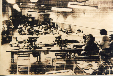 The Beechworth Burke Museum
Photograph, Between 1946 and 1961
... between the late 1940s and early 1960s. Pitman Shoe Factory Elgin ...Elgin Shoes Pty., Ltd., established a branch shoe factory in Beechworth in 1946. Managing director, Mr T Nagle Pitman, selected Beechworth as a suitable location for the factory due to the availability of labour in the town, particularly girls under sixteen years of age. At its peak, the shoe factory employed thirty six women and girls, which also included post-war migrants. After the Second World War, Australia admitted increasing numbers of immigrants in order to fulfil labour requirements for a rapidly inflating demand of consumer goods. These migrants were largely from European Countries in line with the ‘White Australia Policy’. In 1954 Beechworth had 170 migrants from the UK, 102 from Hungary, and 63 from Germany. The factory closed in 1961 as increased centralisation of both populations and industry in the larger nearby towns of Wangaratta and Wodonga lead to the closure of many factories in small towns in the 1960s and 1970s. This photograph is historically significant as it shows the working conditions in a factory primarily staffed by women at some point between the late 1940s and early 1960s. Sepia rectangular photograph printed on matte photographic paperReverse: 14 / AFGA / 6982 / pitman shoe factory, elgin shoe company, industry, shoe factory, shoemaking, working women, post-war migration, factory, white australia policy, mid-twentieth century women's working conditions, twentieth-century working conditions, pitman, elgin, shoe, sewing machine, leather, pittman -
 The Beechworth Burke Museum
Audio - Oral History, Jennifer Williams, Mr Bill Gerrard, 10 August 2000
Bill Gerrard was born in Albury in 1934 and moved to Beechworth in 1960 when his wife was employed as a nurse at Mayday Hills Hospital, later becoming nurse-in-charge. Gerrard first worked for the local railway and then as a taxi driver in Beechworth, and was involved in volunteer fund-raising activities such as raffles for charitable causes. This oral history recording was part of a project conducted by Jennifer Williams in the year 2000 to capture the everyday life and struggles in Beechworth during the twentieth century. This project involved recording seventy oral histories on cassette tapes of local Beechworth residents which were then published in a book titled: Listen to what they say: voices of twentieth century Beechworth. These cassette tapes were digitised in July 2021 with funds made available by the Friends of the Burke.Mr Bill Gerrard's account of his life in Beechworth and the local area during the mid-to-late 20th century is historically and socially significant to the cultural heritage of the region. He recounts aspects of community life and working conditions in Beechworth, particularly during the 1960s and 1970s, as well as conditions for staff and patients at Mayday Hills Hospital where his wife worked during that period. His story also provides insights into economic hardhsip and the role of voluntary fundraising in the Beechworth community. This oral history recording was part of a project conducted by Jennifer Williams in the year 2000 to capture the everyday life and struggles in Beechworth during the twentieth century. This project involved recording seventy oral histories on cassette tapes of local Beechworth residents which were then published in a book titled: Listen to what they say: voices of twentieth century Beechworth. These cassette tapes were digitised in July 2021 with funds made available by the Friends of the Burke.This is a digital copy of a recording that was originally captured on a cassette tape. The cassette tape is black with a horizontal white strip and is currently stored in a clear flat plastic rectangular container. It holds up 40 minutes of recordings on each side.Mr Bill Gerrard /listen to what they say, beechworth, oral history, burke museum, bill gerrard, mayday hills hospital, taxi driver, beechworth railway, religion, beechworth 1960s, beechworth 1970s, social welfare, community cohesion, twentieth-century working conditions, twentieth-century regional victoria, hibernian hotel, fund-raising -
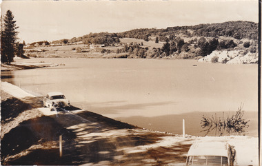 The Beechworth Burke Museum
Photograph, 1960s
Taken around 1960s, this photograph shows the banks of Lake Sambell. Lake Sambell is named after Mr. L. H. Sambell who was instrumental in the lake's formation. Lake Sambell is the original site of the open sluice operation of Rocky Mountain Mining Company in the 1800s and the early 1900s. In the early 1920s, it was reconstructed as a recreational lake and was formally opened to public on 6 October 1928. The opening event was attended by townspeople and Beechworth's Minister of Lands Mr. Bailey. In the late 1930s to early 1940s, Lake Sambell redeveloped. The first development aimed to raise the banks by six feet to double its present area and to make the water cleaner. Another redevelopment in the 1940s was made possible by the Beechworth and District Progress Association. It involved raising the banks to five feet to provide swimming facilities, paddling pool and caravan park. This photograph holds Historic significance because of its connection to the development of Beechworth district.Sepia rectangular photograph printed on matte photographic paperObverse: Reverse: 3533 /beechworth, water scheme, water reserve, catchments, beechworth water reserve, beechworth catchments, municipal council, lakes, reserve, water supply, political projects, environmental changes, mr. l. h. sambell, sambell, rocky mountain mining company, recreational lake, minister of lands, mr. bailey, swimming pool, paddling pool, caravan park, swimming facilities, lake redevelopment, funding -
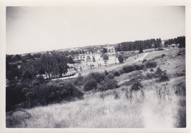 The Beechworth Burke Museum
Photograph, 1960s
This photo was taken in the 1960s from a northeast position looking down towards Lake Sambell, the caravan park, and the surrounding area. This photo was taken during a period of rejuvenation for the lake area including the opening of the caravan park in 1959 and the swimming pool area in 1961 (this pool is just visible in the centre of the photo). The popularity of caravanning in Australia exploded during this post-war period of the late 1950s and 1960’s. This popularity was driven by multiple factors, including: the stopping of fuel rations, the accessibility of car ownership through the manufacturing of affordable cars, technological developments in caravan design, and the increase in prosperity and leisure time for many Australians. Lake Sambell is an artificial lake that was developed on the previous site of the Rocky Mountain Mining Company workings and was officially opened by Minister for Lands, Mr Baily, on October 5, 1928. The disused and unattractive remains of the mine were converted into a recreational area intended for swimming, boating, and fishing. The lake is named after Mr L.H. Sambell, shire engineer and secretary of the Forward Beechworth Committee, who advocated for the enhancement of Beechworth into a tourist destination and was central to the planning and establishment of the lake. Funding for the project was raised by both competition funds and donations. Since the construction in 1928 several engineering issues have arisen. In 1939 the water levels were low, and the lake was considered both an eyesore and ‘mudhole’, Beechworth Shire Council sort funding to raise the height of the lake six feet to improve the quality of water. Throughout the 1940s the Beechworth Swimming Club tried to raise awareness and funds to address the structural engineering issues and improve swimming facilities at the lake. R.E. Carter, similar to L.H. Sambell, was a shire engineer who advocated the importance of positioning Beechworth as a tourist destination. Carter held the position from 1954-63 and organised many improvements to the Lake Sambell area including the caravan park in 1959, the lake swimming pool in 1961, water skiing and boating facilities, and increased the lake surface are in 1964. These improvements were financed mainly by grants from the Tourist Development Authority. This photograph is of historical significance as it documents Lake Sambell and the surrounding area in the 1960s after a phase of enhancements to improve the appearance and usability for both the people of Beechworth and tourists. It is also of social significance in providing an insight into the increase in leisure time and access to travel during a period of post-war prosperity.Black and white rectangle photograph printed on matte photographic paper and unmounted.Reverse: 1 / [logo KODAK/ VELOX/ PAPER] / C798 / 3535lake sambell, lake sambell caravan park, lake sambell swimming pool, caravan park, caravanning 1960s, rocky mountain mining company, l.h. sambell, r.e. carter, beechworth swimming club, forward beechworth committee, minister of lands, tourist development authority, lake swimming, swimming, boating, fishing, water skiing, beechworth 1960s, lake sambell fishing, lake sambell boating -
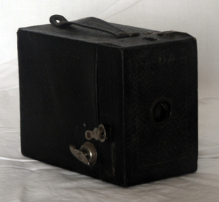 Orbost & District Historical Society
box camera, 1924-1929
They were made from 1913 and they probably weren't very expensive cameras. The Hawk-Eye No. 2 model C of 1913 was a simpler model with just one viewfinder, and no choice of aperture. This version was reissued in 1930 for Kodak's 50th anniversary: For this, the company offered a free Hawk-eye camera to any child of 12 in that year. Approximately 550,000 of these were issued.[A box camera is a simple type of camera, the most common form being a cardboard or plastic box with a lens in one end and film at the other. They were very popular in the late 19th and early 20th centuries. The earliest Kodak's were simple box cameras which were sent to a local dealer after all the shots on the film inside were taken. The dealer developed the film and sent the photographs and the reloaded camera back to the photographer. While introducing a wide range of innovative features two designs dominated Kodak's cameras. The most famous of these was the Box Brownie, designed by Frank Brownell, and introduced at the cost of one dollar in 1900. Brownie's were produced in one form or another up until the 1960s when the Kodak Instamatic was introduced. A Cartridge Hawkeye No. 2 Box Camera. It i has a cardboard body and the body is covered in black leatherette. The camera is designed to be used with Kodak No 120 film. It is a rectangular box with a hole at the front (no lens). The shutter control is on the right side. The film winder is below the latch. The film window is at the back and there is a leather carrying handle at the top. Back - Made in Great Britain Use Kodak No.120 film Kodak Handle - No. 2 Cartridge Hawk-Eye Model Cphotography kodak camera box-camera -
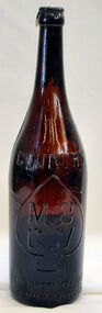 Orbost & District Historical Society
bottle, c 1880 1920 's
Glass bottles were refillable until the 1960s, creating a demand for their collection and onsale back to beverage manufacturers via ‘bottle merchants’.This bottle is an example of a beer bottle commonly used in the late -early 20th century.MBVC brown beer bottle. A narrow bottle with a long neck.MB. Manufacturers Bottle company of Victoria CVbottle glass -
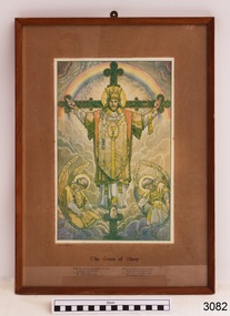 Flagstaff Hill Maritime Museum and Village
Print - Religious Print, T. Noyes Lewis, The Cross of Glory, Mid to late 19th century for the print, the reframing appears to date from the 1960's
The picture was framed by business, Leighton House, paint and art merchants at 346 Little Collins Street, Melbourne. It was made to order, number 6777. The business was also called The Leighton Gallery of Art and was owned by W & G Dean Pty Ltd. The phone number on the label "MU 8291" indicates that the picture was framed circa the 1960s or earlier, during the time that Melbourne was using 6-0digit alpha-numeric numbers. Below the picture is an excerpt of a hymn "The Head that Once was Crowned with Thorns" by Thomas Kelly: The head that once was crowned with thorns Is crowned with glory now; A royal diadem adorns The mighty Victor's brow. The Cross He bore is life and heath, Though shame and death to Him; His people's hope, his people's wealth, Their everlasting theme. This picture was part of the original furnishings of the St Nicholas' Mission to Seamen's Church at 139 Nelson Place, Williamstown, Victoria. THE MISSIONS TO SEAMEN (Brief History: for more, see our Reg. No. 611, Set of Pews) The Missions to Seamen, an Anglican charity, has served seafarers of the world since 1856 in Great Britain. It symbol is a Flying Angel, inspired by a Bible verse. Today there are centr4es in over 200 ports world-wide where seamen of all backgrounds are offered a warm welcome and provided with a wide range of facilities. In Victoria the orgainsation began in Williamstown in 1857. It was as a Sailors’ Church, also known as ‘Bethel’ or the ‘Floating Church’. Its location was an old hulk floating in Hobson’s Bay, Port of Melbourne. It soon became part of the Missions to Seamen, Victoria. In the year 2000 the organisation, now named Mission to Seafarers, still operated locally in Melbourne, Portland, Geelong and Hastings. The Ladies’ Harbour Lights Guild was formed in 1906 to support the Missions to Seamen in Melbourne and other centres such as Williamstown. Two of the most significant ladies of the Guild were founder Ethel Augusta Godfrey and foundation member Alice Sibthorpe Tracy (who established a branch of the Guild in Warrnambool in 1920). The Guild continued its work until the 1960s. In 1943 a former Williamstown bank was purchased for the Missions to Seaman Club. The chapel was named St Nicholas’ Seamen’s Church and was supported by the Ladies’ Harbour Lights Guild, the Williamstown Lightkeepers’ Auxiliary and the League of Soldiers’ and Sailors’ Friends. It ceased operation in 1966. A Missions to Seamen Chapel and Recreation Room was a significant feature of ports during the late 1800s and into the 1900s. It seemed appropriate for Flagstaff Hill to include such a representation within the new Maritime Village, so the Melbourne Board of Management of Missions to Seamen Victoria gave its permission on 21st May 1979 for the entire furnishings of the Williamstown chapel to be transferred to Flagstaff Hill. The St Nicholas Seamen’s Church was officially opened on October 11, 1981 and closely resembles the Williamstown chapel. This picture is significant through its association with the St Nicholas' Mission to Seamen Church in Williamstown, Melbourne, established in 1857. The items in our collection from the Missions to Seamen in Williamstown, Victoria, have historical and social significance. They show that people of the 1800s and 1900s cared about the seafarers’ religious, moral, and social welfare, no matter what the religion, social status or nationality. It had its origins in Bristol, England when a Seamen's Mission was formed in 1837. The first Australian branch was started in 1856 by the Rev. Kerr Johnston, a Church of England clergyman, and operated from a hulk moored in Hobson’s Bay; later the Mission occupied buildings in Williamstown and Port Melbourne. Picture, print of "The Cross of Glory", rectangular, framed print on matt. It depicts Jesus Christ on a cross with an angel on each side, at his feet. He is wearing priestly robes and a gold crown on top of thorns on his head. In the background there is a rainbow and clouds. The text below the picture includes "From the picture by T. Noyes Lewis". Lines from a hymn are also printed below the picture. The back of the picture has pencilled numbers in three places plus a printed label with the framer's details. "From the picture by T. Noyes Lewis". Backing paper has pencil "6777" in two places. Label has bencil "677-" flagstaff hill, warrnambool, shipwrecked coast, flagstaff hill maritime museum, maritime museum, shipwreck coast, flagstaff hill maritime village, great ocean road, the cross of glory, print, t. noyes lewis, leighton house, home decoration, religioius picture, church furnishing, w & g dean pty ltd, leighton gallery of art, religion, religious service, sailors rest, bethel sailors’ church, bethel floating church, ladies harbour light guild, missions to seamen victoria, mission to seafarers, flying angles club, st nicholas mission to seamen church williamstown, mission to seamen williamstown, st nicholas seamen’s church flagstaff hill, 139 nelson place williamstown -
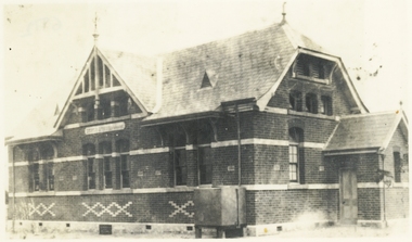 Ringwood and District Historical Society
Photograph, Twenty photographs of Ringwood in frames, 1990
Returned to RDHS from Federation Estate Art GalleryPhoto 1 (7009a) - Former "Ringwood Mail" newspaper office, Adelaide Street, 1955, looking along laneway to west. Lane between Bamford's Timber Yard, corner Warrandyte Rd. and Maroondah Highway, and went to Melbourne St, later called Civic Place. Other buildings were Ham's Billiard Saloon, the two-story Renong Chambers, bottom left Jack Orr's clothes hoists and bottom right Horman & Woolhouse plumbers. All demolished for the building of Eastland in the 1960s. The photo shown is a typical example but may not be in the collection. -
 Ringwood and District Historical Society
Photograph, Infant Welfare Centre-Ringwood-circa 1960s
Black and white photographWritten on back of photo: "Infant Welfare Centre Ringwood built Civic Place-later demolished to make way for Eastland circa 1960s" -
 Bendigo Military Museum
Photograph - Various Photos - Army Headquarters Survey Regiment, Fortuna, Bendigo, c1950s to 1960s
This is a collection of five photographs taken at the Army Headquarters Survey Regiment, Fortuna Villa, Bendigo, circa 1950s to 1960s. Appearing in photo .3P is MAJ Edward Anderson MBE, who served from 1942 to 1977 and reached the rank of LTCOL. LT Frank Thorogood SB St J. served from 1960 to 1981. He reached the rank of LTCOL and was the CO of the Army Survey Regiment from 1980 to 1981. CAPT W. Greer’s service history is unknown. Appearing in photo .5P is MAJ Nolan, who served from 1939 to 1975. He was promoted to LTCOL and was the CO of the Army Headquarters Survey Regiment from 1965 to 1969. He was subsequently promoted to COL and was the Director of Military Survey from 1972 to 1975.This is a collection of five photographs taken at the Army Headquarters Survey Regiment, Fortuna Villa, Bendigo, circa 1950s to 1960s. The photographs were printed on photographic paper and are part of the Army Survey Regiment’s Collection. They were scanned at 300 dpi. .1) - Photo, black and white, 1950s. Regiment briefings by Fortuna’s lake. .2) - Photo, black and white, 1960s. Unidentified officer and civilian visitors in the Officers Mess. .3) - Photo, black and white, 1960s. L to R: MAJ Edward Anderson MBE, CAPT W. Greer and LT Frank Thorogood SB St J; in the Officers Mess. .4) - Photo, black and white, 1962. Regiment parade held in Fortuna’s grounds where the tennis and basketball courts were later developed. .5) - Photo, black and white, 1960s. MAJ John Nolan (centre) with unidentified civilian visitors.Personnel were identified in photos .3P and .5P. The date is annotated on photo .4P.royal australian survey corps, rasvy, army survey regiment, army svy regt, fortuna, asr -
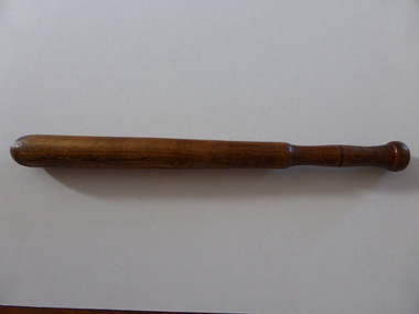 Warrnambool and District Historical Society Inc.
Batton, Police baton AP1340
This police baton or truncheon is typical of the ones used by police in Australia perhaps late in the 19th century or early in the 20th century. No information has yet been found as to the identity of the owner or the significance of the letters, ‘A P 1304’. There are several possibilities as the collection of the old Warrnambool Museum which operated from the 1870s to the 1960s included several police batons. The owner of this baton is not known but is retained pending further research.This is a wooden police baton. The rounded body is tapered towards the top and it has an incised ridge near the top and a knob on the top to form a handle. The ridge at the top may be for holding a string or rope to carry the baton on the wrist. The wood has been varnished but it is now much worn and discoloured. The letters have been etched into the surface.‘A P 1304’ history of warrnambool, police in warrnambool, police baton, police baton ap 1304 -
 Kiewa Valley Historical Society
Trophies - Glass - Tawonga Primary School, 1980
The Tawonga Primary School was a weatherboard building built on 8 acres. In 1900 a fire destroyed the building and its records. The school was then moved to the Old Tawonga Hall before a new one was built in 1910 on land donated by Frank Cooper. In 1937 and 1954 further buildings were added. Tobacco farming and the building of the Kiewa Hydro Electric Scheme increased the number of pupils during the 1950s and 1960s. This glass represents the celebration held when the school became 100 years old.Tawonga Primary School was established for the children of the farmers of the Kiewa Valley in 1880 and later for children of the tobacco farmers and workers on the Kiewa Hydro Electric Scheme. The history of the school reflects the activities of the people living in the valley and in particular Tawonga township.Clear glass with gold metal brim and embossed in gold on two sides. Base is solid tapering up to the glass sides.On one side: Gold embossed picture of school building On opposite side: Gold embossed 2 circles - Inside inner one: 1880 - 1980. Between this and outer circle - Tawonga Primary School No 2282. Underneath both circles gold embossed: Centenarytawonga primary school, kiewa valley, education