Showing 384 items matching "mining plan"
-
 Bendigo Historical Society Inc.
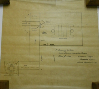
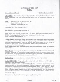
Plan - MARKS COLLECTION: PLAN NEW BOILER LANSELL'S LITTLE 180 MINE
... MINING lansell's little 180 mine George Lansell gold mining ...Plan drawn on buff coloured waxed paper. Written on bottom: 'No. 1 Arrangement New Boiler for Lansells Proprietary Little 180 Mine Bendigo. Scale 1/4 inch = 1 foot. Hargraves & Daggar, Consulting Engineers, Victoria Chambers Bendigo' Plan shows entry of tramway, fuel store, boiler room, stack (75 ft), driving platform, winding engine, view to shaft.mining, lansell's little 180 mine, george lansell, gold mining, bendigo -
 Bendigo Historical Society Inc.
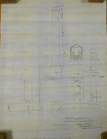
Plan - MARKS COLLECTION: PLAN EXTRA BOILER LANSELL'S 180 MINE
Engineering drawings for the (written on bottom of plan) 'No 2-arrangement extra boiler for Lansells Proprietary little 180 Mine Bendigo Plan shows chimney - side elevation, measurements of chimney, flue, boiler (and existing boiler, existing loco boiler) On bottom of plan: Scale 1/4 inch = 1 foot. Hargreaves & Daggar, Consulting Engineers, Victoria Chambers, Bendigo.mining, equipment, lansell's little 180 mine -
 Bendigo Historical Society Inc.
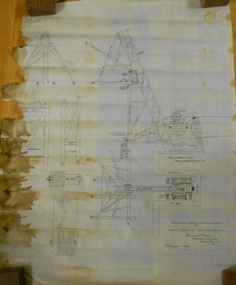
Document - MARKS COLLECTION: PLAN LANSELL'S COMET PROPRIETARY MINE BENDIGO
Plan (engineering drawings) for construction of crushing and elevating plant at Lansell's Comet Proprietary Mine, Bendigo. Drawings show detail for crusher and elevator, brick foundations. Plan is annotated with e.g. number of revolutions of jaw crusher. On bottom written in black pen: arrangement crushing and elevation plant for Lansell's Proprietary Comet Mine Bendigo, Hargreaves & Daggar, Consulting Engineers, Victoria Chambers.mining, crushing & milling, lansell's comet mine -
 Bendigo Historical Society Inc.
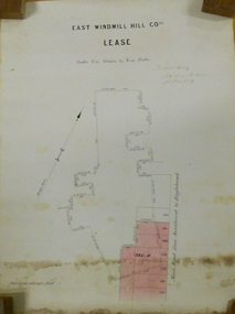
Plan - MARKS COLLECTION: EAST WINDMILL HILL CO LEASE PLAN
Plan on heavy paper. On top of plan ' East Windmill Hill Coy's Lease, scale one inch to one chain' Signed in ink by Thomas McNulty (?) Mining Engineer. On RH side of plan written 'Main Road from Sandhurst to Eaglehawk'.bendigo, mining, east windmill hill lease co -
 Bendigo Historical Society Inc.
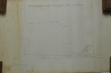
Plan - MARKS COLLECTION: PLAN OF UNDERGROUND WORKINGS CINDERELLA COMPANY, JOHNSON'S REEF
... BENDIGO Mining cinderella company Plan on heavy parchment ...Plan on heavy parchment paper: on top of plan 'Plan of the underground workings Cinderella Company, Johnson's Reef' Lh side of plan 'Kent Company's Ground' on bottom: Tipper and Company. Written on bottom surveyed 13/7/64.bendigo, mining, cinderella company -
 Bendigo Historical Society Inc.
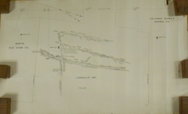
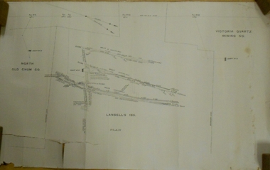
Plan - MARKS COLLECTION: LANSELL'S 180 PLAN, LEVELS 18, 19 AND 20
Plan of underground section of Lansell's 180 mine, levels 18, 19 and 20. On RH side of map Victoria Quartz Mining company claim marked, on LH side North Old Chum Co. 'West or hanging wall' marked above each level.bendigo, mining, lansell's little 180 mine -
 Bendigo Historical Society Inc.
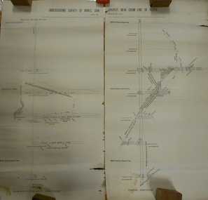
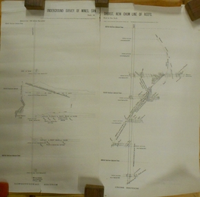
Document - MARKS COLLECTION: UNDERGROUND SURVEY OF MINES NEW CHUM LINE OF REEFS
... BENDIGO Mining new chum reef Plan, in two sections ...Plan, in two sections, on heavy parchment coloured paper. Printed across top in black ink 'Underground Survey of Mines New Chum Line of Reefs' a. Shows cross section of mine, b. longitudinal section. Drawn by Arthur Everett, Mining Department, Melbourne 1884. Surveyed by Caleb Thomas under the direction of Charles Langtree. Plan found in George Lansell auction items. Plan found in George Lansell items sold at auction.bendigo, mining, new chum reef -
 Bendigo Historical Society Inc.
Document - MARKS COLLECTION: LANSELL'S 180 MINE PLAN
... BENDIGO Mining lansell's 180 mine Plan on heavy parchment ...Plan on heavy parchment paper. Printed on bottom of plan 'Lansell's 180 plan' On top RH corner 'Victoria Quartz Mining Co' On LH side 'North Old Chum Co' Plan shows rock formation e.g. quartz lava slide. Plan found in documents from George Lansell auction, donated by Phillipa Marks.bendigo, mining, lansell's 180 mine -
 Bendigo Historical Society Inc.
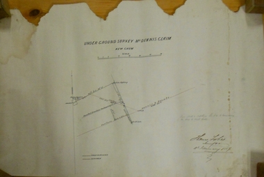
Plan - MARKS COLLECTION: UNDERGROUND SURVEY MR. DENNIS CLAIM NEW CHUM
Plan on heavy parchment paper. On top of plan 'underground survey Mr. Dennis, New Chum' Signed: Thomas Forbes, Surveyor, 11th. January 1867. shows surface boundary of Dennis and Bonati. Written in blue pencil 'From nail in sapling 33f. 51/2 to boundary. Online to drill hole' Shaft marked on LH boundary.'bendigo, mining, mr. dennis claim, new chum -
 Bendigo Historical Society Inc.
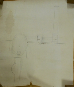
Document - MARKS COLLECTION: PLAN OF CHIMNEY STACK
Unlabeled plan, drawing shows side view of chimney stack, '5 feet' written on base of chimney. Plan could be associated with a mine on New Chum Reef Line, Victoria Hill.bendigo, mining, chimney side section, chimney stack -
 Bendigo Historical Society Inc.
Plan - MARKS COLLECTION: UNDERGROUND SURVEY OF MINES SANDHURST NEW CHUM LINE OF REEF
... BENDIGO Mining new chum line of reef Plan, divided into two ...Plan, divided into two sheets, on top of sheet Underground survey of mines Sandhurst, New Chum Line of Reef. Surveyed by Caleb Thomas under the direction of Charles W. Langtree, Acting Secretary for Mines and Water Supply and Acting Chief Mining Surveyor for the Colony of Victoria. Drawn by Arthur Everett, Mining Department, Melbourne, 1884.bendigo, mining, new chum line of reef -
 Bendigo Historical Society Inc.
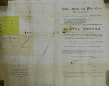
Document - MARKS COLLECTION: BOUNDY'S FREEHOLD GOLD MINES MALMSBURY
... Nutman, Mining Manager, Queens Birthday Company; Report on Plan... Plan by Walter Sleeman, Mining Mgr., Oct 9th. 1888. On RH side ...Plan/advertisement 1888 for the sale of the Boundy's Freehold Gold Mines Malmsbury, 260 acres of auriferous and arable freehold land. Document contains map of mines, names include O'Connors Freehold Company, Egyptian Company, Queen's Birthday Company, No.1 South Queen Company, Madam O'Connor's company, Extended South Queen's Birthday Company. Scale 10 chains to one inch. Taken from Mr. H. Archdale's Plan by Walter Sleeman, Mining Mgr., Oct 9th. 1888. On RH side of map Daylesford Road to Malmsbury marked. The land is only about two miles from the Malmsbury railway station. On back of document letter from Henry Nutman, Mining Manager, Queens Birthday Company; Report on Plan Walter Skleeman, M.M.; letter to S. Deeble, 35 Queen St., Melbourne with report on mine from George Jenkyn and Mining Manager's Report in Argus 24th.October 1888.mine, gold, boundy's freehold gold mine -
 Bendigo Historical Society Inc.
Document - LANSELL'S BIG 180 MINE - CONDENSED HISTORICAL RECORD OF LANSELL'S BIG 180 MINE
... observations from old photographs and measurements of mining plans ...Two handwritten and three typed copies of a Condensed Historical Record of Lansell's Big 180 Mine on the New Chum Line of Reef. Notes include location, shaft, first worked, size of lease, plant, engine house, boiler rooms, mullock heap, early history, Prominent, best gold, underground connections, pressurised hot water, diamond drill bores and a table with depths and the increase in temperature with the depth (in Fahr). Albert Richardson Collection. document, gold, lansell's big 180 mine, lansell's big 180 mine, condensed historical record of lansell's big 180 mine, wittscheibe, ballerstadt, ernst mueller, theodore ballerstadt, george lansell, north old chum, victoria quartz, mines dept special edition 'australian mining standard' 1/6/1899, mines dept booklet 'bendigo goldfield' 1936, quarterly reports, lansell's 180 mine 'transverse sections, annals of bendigo mining sections, a richardson's observations from old photographs and measurements of mining plans, measurements taked from caleb thomas' report mines dept 1875, 'report on observation of underground temperature at bendigo' james stirling government geologist 1899, a richardson -
 Bendigo Historical Society Inc.
Document - MARKS COLLECTION: SECTION OF MAIN CHANNEL
... BENDIGO Mining water channel section Plan drawn on waxed ...Plan drawn on waxed type paper, fragile. Written in centre of map 'Section on Centre of Main Channel, Scale horizontal 2 chs, vertical 10ft., to an inch'. Plan shows Melbourne Road on top section. Written in red ink '5,000,000 galls in 24 hours = 3472.2 gals per minute'. Plan located in documents from George Lansell auction.bendigo, mining, water channel section -
 Bendigo Historical Society Inc.
Document - NORTH JOHNSONS MINE - NOTES ON THE NORTH JOHNSONS MINE
One typed, one handwritten and one handwritten carbon copy of notes on the North Johnsons Mine on the Garden Gully Line of Reef. Notes include size of lease (which was very small, only 83 yards along the line of reef, and the late 1890's absorbed the Rose of Denmark lease, the next mine north, of 57 yeards along the line of reef, Depth of shaft, height of Sill, Locality, Plant, Early History, Prominence, Best Gold, Total Gold Yield and Dividends,Underground Connections and References. Albert Richardson Collection. document, gold, north johnsons mine, north johnsons mine, garden gully line of reef, rose of denmark, camerons reef, dagmar reef, johnsons no 1, johnsons no 2, special edition australian mining standard 1/6/1899, mines dept booklet bendigo goldfield geo brown 1936, mines dept quarterly and annual reports, annals of bendigo mining sections 1866 - 1917, a richardson, e j dunn's special report no 1 measurements taken from north johnsons mine transverse section 22/9/1892, wood & mcnair sharebrokers plan of leases of portion of bendigo goldfield to 4/5/1912 -
 Lakes Entrance Historical Society
Book, Government Printer, Reports of the Mining Registrars for the quarter ended 31st December 1887, 1887
Reports of the Mining Registrars for Mining Districts of Ballarat Beechworth Sandhurst Maryborough castlemaine Ararat and Gippsland to 31st December 1887 Geological details mine plans and maps are included.mines and mining, government, geographic -
 Federation University Historical Collection
Map, Ballaarat Gold Field, 1861, 21/10/1861
A party of surveyors camped by Yuille's Swamp (later Lake Wendouree) and surveyed the countryside for a map to be produced by the Geological Survey of Victoria. In November 2004 the Central Highlands Regional Library presented a special edition of 200 copies of the 1861 map reproduced from a copy in their collection. Original geological map of Ballarat showing property, waterways, mines, churches, schools, water races, and garden reserves. It was compiled and drawn from the surveys of Mining Surveyors Davidson, Fitzpatrick and Cowan.Compiled & Drawn from the Survey of Mining Surveyors Davidson, Fitzpatrick and Cowan & the Plans in the Surveyor General's Office by J. Brahe, 21st October 1861. R. Brough Smyth, Secretary for Mines. The Honourable J.B. Humffray, M.L.A. Commr of Mines.ballarat, map, davidson, robert brough-smyth, fitzpatrick, cowan, yuille's swamp, public garden reserve, manure depot, black hill, ballarat east, old post office hill, pennyweight hill, claytons hill, golden point, mining, railway, cricket ground, swamp creek, cemetery, sludge reserve, bakery hill, gaelic church, juvenile reformatory, orphanage, specimen hill, eureka lead, cattle yard hill, dalton's flat, chinese village, poverty hill, railway reserve, little bendigo diggings, pound reserve, allied armies, flour mill, agricultural reserve, marsh, survey reserve, survey corps, white flat, yarrowee, yarrowee creek, brache, j. brache, survey, ballaarat gold field 1861 -
 Bendigo Historical Society Inc.
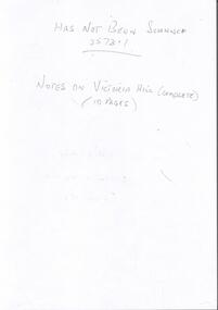
Document - RAE'S CRUSHING BATTERY - THE RICH VICTORIA HILL & ITS HISTORICAL ASSOCIATIONS
The first five pages are photocopies of photos:- 2 of Rae's Crushing Works; Victoria Quartz on Victoria Hill, Ironbark; Looking North from Old Chum Hill to the Victoria Hill; Victoria Hill - from Rae's Open Cut. Introduction covers location of buildings and mines. Mentioned are:- North Old Chum Mine, Ballerstedt's First Open-cut, Quartz Veins (Spurs), rock formations pitching North, Prospecting shafts 1929, Concrete dam, Engine beds of Lansells Big 180 Mine, Lansells Big 180 Shaft, twenty stampers crushing battery, Lansell's Cleopatra Needle type chimney, Victoria Quartz Mine, Victoria Quartz dams, Rae's Open-cut, Quartz once roasted here to an intense heat, Anticlinal Arch New Chum Line, small primitive tunnels, Prospecting tunnels, Floyd's small 5 head crushing battery, Great Central Victoria (Midway) Shaft, Great Central Victoria engine-bed, Ballerstedt's small 24 yard claim, The Humboldt, Adventure ground, The Advance, Luffsman & Sterry's Claim, A round shaft. Small piece of paper with 'Notes on Victoria Hill complete. Notes prepared by Albert Richardson.document, gold, rae's crushing battery, rae's crushing battery, rae's crushing works, victoria quartz mine, from old chum hill, victoria hill from rae's open cut, ironbark, hercules & energetic, midway, wittscheibe, great central victoria, mr & mrs conroy, central nell gwynne, gold mines hotel, john brown knitwear factory, new chum & victoria, rotary club of bendigo south, north old chum, ballerstedt's first open-cut, lansell's big 180 shaft, cleopatra needle type chimney, a roberts & sons, mr e j dunn, h harkness & sons, eureka extd, new chum railway, pearl, inrush of water at victoria quartz, floyd's small 5 head crushing battery, great central victoria (midway), ballertedt's small 24 yard claim, humboldt, humboldt, great central victoria, victoria hill, bendigo & vicinity 1895 p51, j n macartney 1st edition 1871, bendigo goldfield registry 1871, plan of new chum line, mr rae anderson, annals of bendigo obituary 1904, bendigo advertiser, b m l records mines dept, patterson's goldfields of victoria, dickers mining record 23/11/1861, australian mining standard special edition 1/6/1899 p40, bendigo mines ltd, chinese joss house, fortuna, the victoria goldfield 1851 to 1954, the victoria hill 1854 to 1949 -
 Bendigo Historical Society Inc.
Document - THE SEA GOLD MINING AMALGAMATED COMPANY N. L. - NOTES ON THE SEA GOLD MINING
Carbon copy of notes, with typed copy of same, on The Sea Gold Mining Amalgamated Company N. L. on the Garden Gully Line of Reef. Notes include size of lease, office, locality of shaft, sill and depth of shaft, plant, first & last crushing, Prominence, call and dividends, gold yield, best gold and underground connections. Signed by A Richards. Written at the top of page: Original to Mr R Leach, Manager, Allan's Music . Notes prepared by Albert Richardson.document, gold, the sea gold mining amal coy n l, the sea gold mining amalgamated company n. l., notes on the sea gold mining amalgamated company n. l., mccoll & rankin, mines dept plan 1937, annals of bendigo mining sections, g brown bendigo goldfield 1936, wood & mcnair s'brokers 1912, v pabst bendigo goldfields central area 1917, mines dept records, a richardson -
 Bendigo Historical Society Inc.
Document - VICTORIA HILL - VISITOR PLANS FOR VICTORIA HILL
Handwritten carbon copy and typed copy of notes on 1st and 2nd stage plans for a tourist area on approx. 20 acres at Victoria Hill. First stage was to clean up the area, locate and sign post shafts, engine beds, etc and prepare a topographical map with these features on it. Second stage was to arrange for the purchase of typical miners homes and shops in the vicinity to be restored for inspection by visitors. Mining equipment to be placed in the area. Prepare brochures for sale. Set up a mining museum.Prepare an area near BCV 8 with direction finder to mining and general features, as this has the best natural ground level view in the City. Notes prepared by Albert Richardson.mine, gold, victoria hill, victoria hill, visitor plans for victoria hill, darrel mcclure, bendigo city council, bendigo historical society, central nell gwynne, caleb thomas, bcv 8, lazarus, old chum, new chum, victoria, repeater station (p. m. g.) -
 Bendigo Historical Society Inc.
Document - MINING REPORTS - MINING REPORTS BY A RICHARDSON
Handwritten reports dated May 1968 by A. Richardson. On the 4th May visitors from Hobart toured the Central Nell, Victoria and New Chum Hill areas. Also on the 4th, a visit from Mr Geo Lambert who gave him a geological report of the Victoria Hill area. On the 13th May, a visit from Mr K W Smith who showed him slides of derelict W. A. mines. Also plans for the preservation of Mining in Bendigo at Victoria Hill and the preservation of the Central Nell Gwynne poppet legs.document, mining reports, mining reports by a richardson, mr geo lambert, hon j c balfour, mr n wakefield, mr k w smith, le fevre boy's tech high school, mrs f leak, mr perry, gt extended hustlers, central nell gwynne, the pioneer, gunther & party, lansell's fortuna, mt alvernia hospital, a richardson, devonshire mines, bendigo & district tourist association, mrs checcucci, mr jackman, mr greenway, r a c v, cl gerry, eureka extended, bendigo branch historical society -
 Bendigo Historical Society Inc.
Document - MINING REPORTS - CALEB THOMAS PLANS
... DOCUMENT Gold mining reports Mining Reports Caleb Thomas ...(a) Copy of Caleb Thomas Plan - Sheet No VI (774) on the New Chum Line dated 4/12/1885. Plan shows the new St Mungo, Duchess Tribute, South Devonshire, Alberts Shaft, Duchess of Edinburgh, United Devonshire (later W. V. Devonshire), Princess Alexandra (later The United Devonshire) and the Ext'd St Mungo. (b) Sheet No VA (775) dated 30/5/1885. Eaglehawk District. Mines mentioned are: Phoenix Coy, Unicorn Coy Lease, Unicorn Shaft, Sth St Mungo, St Mungo Coy and the Lady Barkly. Also some numbered, unnamed shafts. Plans mentions shaft number, no of compartments and distance in yards and feet between each mine. Document is part of the Albert Richardson Collection. document, gold, mining reports, mining reports, caleb thomas plans, st mungo, duchess tribute, south devonshire, alberts shaft, duchess of edinburgh, united devonshire (later w. v. devonshire), princess alexandra (later the united devonshire), ext'd st mungo, phoenix coy, unicorn co lease, unicorn shaft, sth st mungo, st mungo coy, lady barkly -
 Bendigo Historical Society Inc.
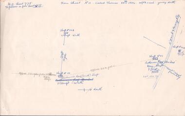
Document - MINING REPORTS - CALEB THOMAS PLANS
... Collection. Document MINING REPORTS - CALEB THOMAS PLANS ...Copy of Caleb Thomas plans, (a) Sheet No 778, dated 24th 1884. Mines mentioned are: Catherine Reef (South) Shaft, Catherine Reef United Main Shaft, Shaft No 50B, Shaft No 51A North Shaft and the Williams Main Shaft. Mentioned are distances from each mine in yards and from the Eaglehawk to Kerang Railway in feet. Also mentioned are ounces of gold. (b) Sheet No III dated 10/10/1884. Mines mentioned are: York & Durham, Arcadia Catherine, Williams (Old) Shaft, Trio-Hauling Co, South Catherine (later Williams United Main Shaft and others by shaft numbers. Mentioned are distances in yards or feet from each mine, number of compartments and ounces of gold. Document is part of the Albert Richardson Collection.document, gold, mining reports, mining reports, caleb thomas plans, york & durham, acadia catherine, williams (old) shaft, trio-hauling co, south catherine (later williams united main shaft -
 Bendigo Historical Society Inc.
Document - MINING REPORTS - CALEB THOMAS PLANS
... . Document MINING REPORTS - CALEB THOMAS PLANS ...Copy of Caleb Thomas Plan. Sheet No IV, dated 19/1/1885. Mines mentioned are: St Mungo , Sadowa, Ellenborough and the Belmont & Saxby. Also mentioned are Shaft No 38 and Shaft No 40A. Distances between each shaft in yards or feet, number of compartments and ounces of gold. Document is part of the Albert Richardson Collection. document, gold, mining reports, mining reports, caleb thomas plans, st mungo, sadowa, ellenborough, belmont & saxby -
 Bendigo Historical Society Inc.
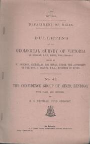
Book - MINING REPORTS - THE CONFIDENCE GROUP OF MINES BULLETIN NO 41
Light brown covered booklet 'Bulletins of the Geological Survey of Victoria issued by W Dickson, Secretary for Mines, Under the Authority of the Hon. S Barnes M L A Minister of Mines. No 41 The Confidence Group of Mines, Bendigo with Plans and Sections by H S Whitelaw, Field Geologist, dated 1918. Mines mentioned are: Confidence Extended Mine, Confidence Tribute Company and the Central Windmill Hill Mine. Mentioned in the report are crushings and gold yield, details of levels, names of leases along the reef. Extracts from Mine Manager's Half-yearly Reports, 1878-1915 of tons crushed and gold yield. Plans and sections of the Confidence Extended Mine on the Garden Gully Line of Reefs are: Plate I General Plan of All Levels, Plans of Levels Plate No II, Plans of Levels Plate No III, Transverse Section Plate No IV, Longitudinal Section Plate No V, and Central Windmill Hill Mine Transverse Section Plate No VI. Plates signed by H S Whitelaw 17 & 18/6/16 and 20/7/16. Booklet if part of the Albert Richardson Collection. book, bendigo, mining reports, mining reports, the confidence group of mines bulletin no 41, confidence extended mine, confidence tribute company, central windmill hill mine, department of mines, bulletins of the geological survey of victoria, w dickson, the hon s barnes, h s whitelaw, h j green, mr robert eddy, mr w h cundy, j foster, c j thompson -
 Bendigo Historical Society Inc.
Document - MINING REPORTS - NORTH JOHNSON'S MINE MANAGERS' REPORTS
The North Johnson Gold Mine was situated in California Gully, Bendigo. See Trove article and plan of mine: https://trove.nla.gov.au/newspaper/article/7918876Handwritten extracts, by Albert Richardson, with typed copy of same, from the North Johnsons Mine Managers, F. Agnew, G. Roberts and J. Veale's Reports dated from 8th July 1898 to 27th Feb 1908. Report mentions cage being hung up and rope being caught and stuck, cutting down of shaft, repair of winding rope, cutting down and timbering of shaft, miner burnt when candle flared, which was believed to be caused by gas, sinking of shaft and water heavy and recommend to stop sinking shaft and start to cut a plat. (b) Report dated 29-11-1906 mentions a typhoon destroying the east side of the engine-house. This was repaired and also cleaned flues and boilers and ventilation at 3273 and 3471 feet.gold, mining reports, north johnson's mine managers' reports, f agnew, p schadendorff, the 'rose' plant, g roberts, j veale, inspector williamson -
 Ballarat Heritage Services
Photograph - Digital photographs, L.J. Gervasoni, Sacred Heart Kew, c2015
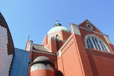
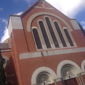
In 1872 members of the Jesuits purchased land in Walpole Street. Three years later, on 14 February 1875, Archbishop Gould laid a foundation stone for a school. By 1899 the land for the current church was purchased after mining speculator and Mt Lyell 'Copper King' James Crotty donated 3,000.00 pounds. The foundation stone was laid on 15 December 1918 by Archbishop Danial Mannix. The cost of constructing the domed church was 15,000.00 pounds. NEW PRESBYTERY AT KEW. Plans have been prepared by Mr. R. Harper, architect and builder, for the erection of a new presbytery for the Rev. P. Rafferty, adjoining the Sacred Heart Church, Cotham-road, Kew. The new building, which will be in brick and of two stories, will be behind the present priests' residence, which will continue to be used until the new presbytery is completed. The cost will be £6000, and the work will be begun almost immediately. The old presbytery was purchased many years ago by the late Rev. Fr. P. O'Donohue from the late Mr. Smart for £3000, and the full amount of the purchase money was donated by the late Mr. James Crotty. At different times additions were made to the building, but the small rooms made it altogether unsuitable as a residence for three priests, and made remodelling impracticable. The new presbytery will be in keeping with the Church of the Sacred Heart and the surroundings on the elevated site. At one time the old Sacred Heart Church was in Walpole-street, Kew. (The Advocate, 09 December 1937) The whole of the estate of the late Jas. Crotty has now been realised excepting 4000 shares in the Mount Lyell Company and a small parcel of general mining shares. All the debts and legacies, including £10,000 to St. Patrick's and £3300 to the testator's parish church at Kew, and also probate duty, have been paid. On present values the Mount Lyell shares. are worth a total of £37,000, and at the present rate of dividends the return represents an income of about £2000 per annum. Over and above this there is a sum of between £20,000 and £30,000 available for investment, and this, together with the dividends brings the income of the estate up to about £3000 per annum. A sum of £1100 per annum will be absorbed in annuities under the terms of the will. Whatever amount is realised beyond the sum necessary to pay the annuities goes to Archbishop Carr for the church and charitable purposes until the death of the last annuitant, when the residuary estate will be divided between the Little Sisters of the Poor (North cote) and St. Joseph's Home (Surrey Hills). (Launceston Examiner, 18 July 1899) Sunday last being the anniversary of the opening of the Sacred Heart Church, Kew, the pastor, Rev. Fr. Manly, made a special appeal at the various Masses. The beautiful design for marble altar for the Lady Chapel, which is on view in the vestibule, continues to attract attention. The Children of Mary Sodality have kindly undertaken to provide it, and the president, Miss Frances O'Sullivan, 43 Rideway-avenue, Kew, will be pleased to receive and acknowledge subscriptions from clients of Our Lady. They may also be placed in box near Lady Altar. (The Advocate, 06 December 1923) A Fincham and Sons organ was installed in 1927, and refurbished in 1977.Colour photograph of a brick church in Kew called Sacred Heart.kew, sacred heart, catholic church, danial mannix -
 Ballarat Heritage Services
Photograph, Clare Gervasoni, Exterior of Sacred Heart Kew, 01/03/2015
In 1872 members of the Jesuits purchased land in Walpole Street. Three years later, on 14 February 1875, Archbishop Gould laid a foundation stone for a school. By 1899 the land for the current church was purchased after mining speculator and Mt Lyell 'Copper King' James Crotty donated 3,000.00 pounds. The foundation stone was laid on 15 December 1918 by Archbishop Mannix. The cost of constructing the domed church was 15,000.00 pounds. A Fincham and Sons organ was installed in 1927, and refurbished in 1977. NEW PRESBYTERY AT KEW. Plans have been prepared by Mr. R. Harper, architect and builder, for the erection of a new presbytery for the Rev. P. Rafferty, adjoining the Sacred Heart Church, Cotham-road, Kew. The new building, which will be in brick and of two stories, will be behind the present priests' residence, which will continue to be used until the new presbytery is completed. The cost will be £6000, and the work will be begun almost immediately. The old presbytery was purchased many years ago by the late Rev. Fr. P. O'Donohue from the late Mr. Smart for £3000, and the full amount of the purchase money was donated by the late Mr. James Crotty. At different times additions were made to the building, but the small rooms made it altogether unsuitable as a residence for three priests, and made remodelling impracticable. The new presbytery will be in keeping with the Church of the Sacred Heart and the surroundings on the elevated site. At one time the old Sacred Heart Church was in Walpole-street, Kew. (The Advocate, 09 December 1937) The whole of the estate of the late Jas. Crotty has now been realised ex cepting 4000 shares in the Mount Lyell Company and a small parcel of general mining shares. All the debts and legacies, including £10,000 to St. Patrick's and £3300 to the testator's parish church at Kew, and also probate duty, have been paid. On present values the Mount Lyell shares. are worth a total of £37,000, and at the present rate of dividends the return represents an income of about £2000 per annum. Over and above this there is a sum of between £20,000 and £30,000 available for investment, and this, together with the dividends brings the income of the estate up to about £3000 per annum. A sum of £1100 per annum will be absorbed in annuities under the terms of the will. Whatever amount is realised beyond the sum necessary to pay the annuities goes to Archbishop Carr for the church and charitable purposes until the death of the last annuitant, when the resi duary estate will be divided between the Little Sisters of the Poor (North cote) and St. Joseph's Home (Surrey Hills). (Launceston Examiner, 18 July 1899) Sunday last being the anniversary of tire opening of the Sacred Heart Church, Kew, the pastor, Rev. Fr. Manly, made a special appeal at the various Masses. The beautiful design for marble altar for the Lady Chapel, which is on view in the vestibule, continues to attract attention. The Children of Mary Sodality have kindly undertaken to provide it, and the president, Miss Frances O'Sulliv!an, 43 Rideway-avenue, Kew, will be pleased to receive and acknow r ledge subscriptions from clients of Our Lady. They may also be placed in box near Lady Altar. (The Advocate, 06 December 1923)Exterior of Sacred Heart Catholic Church Kew. sacred heart, kew, catholic church -
 Ballarat Heritage Services
Photograph - Church, First Sacred Heart Catholc Church Kew
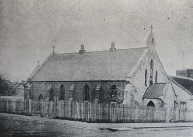
In 1872 members of the Jesuits purchased land in Walpole Street. Three years later, on 14 Februrary 1875, Archbishop Gould laid a foundation stone for a school. By 1899 the land for the current church was purchased after mining speculator and Mt Lyell 'Copper King' James Crotty donated 3,000.00 pounds. The foundation stone was laid on 15 December 1918 by Archbishop Daniel Mannix. The cost of constructing the domed church was 15,000.00 pounds. NEW PRESBYTERY AT KEW. Plans have been prepared by Mr. R. Harper, architect and builder, for the erection of a new presbytery for the Rev. P. Rafferty, adjoining the Sacred Heart Church, Cotham-road, Kew. The new building, which will be in brick and of two stories, will be behind the present priests' residence, which will continue to be used until the new presbytery is completed. The cost will be £6000, and the work will be begun almost immediately. The old presbytery was purchased many years ago by the late Rev. Fr. P. O'Donohue from the late Mr. Smart for £3000, and the full amount of the purchase money was donated by the late Mr. James Crotty. At different times additions were made to the building, but the small rooms made it altogether unsuitable as a residence for three priests, and made remodelling impracticable. The new presbytery will be in keeping with the Church of the Sacred Heart and the surroundings on the elevated site. At one time the old Sacred Heart Church was in Walpole-street, Kew. (The Advocate, 09 December 1937) The whole of the estate of the late Jas. Crotty has now been realised ex cepting 4000 shares in the Mount Lyell Company and a small parcel of general mining shares. All the debts and legacies, including £10,000 to St. Patrick's and £3300 to the testator's parish church at Kew, and also probate duty, have been paid. On present values the Mount Lyell shares. are worth a total of £37,000, and at the present rate of dividends the return represents an income of about £2000 per annum. Over and above this there is a sum of between £20,000 and £30,000 available for investment, and this, together with the dividends brings the income of the estate up to about £3000 per annum. A sum of £1100 per annum will be absorbed in annuities under the terms of the will. Whatever amount is realised beyond the sum necessary to pay the annuities goes to Archbishop Carr for the church and charitable purposes until the death of the last annuitant, when the resi duary estate will be divided between the Little Sisters of the Poor (North cote) and St. Joseph's Home (Surrey Hills). (Launceston Examiner, 18 July 1899) Sunday last being the anniversary of tire opening of the Sacred Heart Church, Kew, the pastor, Rev. Fr. Manly, made a special appeal at the various Masses. The beautiful design for marble altar for the Lady Chapel, which is on view in the vestibule, continues to attract attention. The Children of Mary Sodality have kindly undertaken to provide it, and the president, Miss Frances O'Sulliv!an, 43 Rideway-avenue, Kew, will be pleased to receive and acknow r ledge subscriptions from clients of Our Lady. They may also be placed in box near Lady Altar. (The Advocate, 06 December 1923)Stone church with buttresses and portio.sacred heart kew, church -
 Ballarat Heritage Services
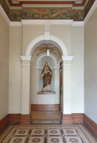
Photograph, Sacred Heart Mercy Convent, Victoria Street, Ballarat East
In 1872 members of the Jesuits purchased land in Walpole Street. Three years later, on 14 February 1875, Archbishop Gould laid a foundation stone for a school. By 1899 the land for the current church was purchased after mining speculator and Mt Lyell 'Copper King' James Crotty donated 3,000.00 pounds. The foundation stone was laid on 15 December 1918 by Archbishop Mannix. The cost of constructing the domed church was 15,000.00 pounds. A Fincham and Sons organ was installed in 1927, and refurbished in 1977. NEW PRESBYTERY AT KEW. Plans have been prepared by Mr. R. Harper, architect and builder, for the erection of a new presbytery for the Rev. P. Rafferty, adjoining the Sacred Heart Church, Cotham-road, Kew. The new building, which will be in brick and of two stories, will be behind the present priests' residence, which will continue to be used until the new presbytery is completed. The cost will be £6000, and the work will be begun almost immediately. The old presbytery was purchased many years ago by the late Rev. Fr. P. O'Donohue from the late Mr. Smart for £3000, and the full amount of the purchase money was donated by the late Mr. James Crotty. At different times additions were made to the building, but the small rooms made it altogether unsuitable as a residence for three priests, and made remodelling impracticable. The new presbytery will be in keeping with the Church of the Sacred Heart and the surroundings on the elevated site. At one time the old Sacred Heart Church was in Walpole-street, Kew. (The Advocate, 09 December 1937) The whole of the estate of the late Jas. Crotty has now been realised ex cepting 4000 shares in the Mount Lyell Company and a small parcel of general mining shares. All the debts and legacies, including £10,000 to St. Patrick's and £3300 to the testator's parish church at Kew, and also probate duty, have been paid. On present values the Mount Lyell shares. are worth a total of £37,000, and at the present rate of dividends the return represents an income of about £2000 per annum. Over and above this there is a sum of between £20,000 and £30,000 available for investment, and this, together with the dividends brings the income of the estate up to about £3000 per annum. A sum of £1100 per annum will be absorbed in annuities under the terms of the will. Whatever amount is realised beyond the sum necessary to pay the annuities goes to Archbishop Carr for the church and charitable purposes until the death of the last annuitant, when the resi duary estate will be divided between the Little Sisters of the Poor (North cote) and St. Joseph's Home (Surrey Hills). (Launceston Examiner, 18 July 1899) Sunday last being the anniversary of tire opening of the Sacred Heart Church, Kew, the pastor, Rev. Fr. Manly, made a special appeal at the various Masses. The beautiful design for marble altar for the Lady Chapel, which is on view in the vestibule, continues to attract attention. The Children of Mary Sodality have kindly undertaken to provide it, and the president, Miss Frances O'Sulliv!an, 43 Rideway-avenue, Kew, will be pleased to receive and acknowledge subscriptions from clients of Our Lady. They may also be placed in box near Lady Altar. (The Advocate, 06 December 1923) Number of photographes of the entrance to Sacred Heart Mercy Convent, Victoria Street, Ballarat East, as well as stained glass windows in the chapel.sacred heart mercy convent, ballarat east, stained glass window, sacred heart of jesus, john hove, announciation, kathleen blanche meagan, sacred heart college