Showing 1898 items
matching new north
-
 Bendigo Military Museum
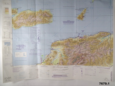
Map - MAPS, EAST TIMOR, US Govt et al, 1975 - 1976
1. This is a coloured map. It's scale is 1.250,000 - called a jpoint operations graphic. It covers the North side of East Timor. Dili is in the centre. Its shows 4 Islands to the north of Timor. It shows Savu Fea, Ombai Strait, Wetar Strait. On bottom left of map it shows Batheade and the start of the New Border. Map - Series 159. Sheet 5C- 51-4. Edition 3-GSGS. 2. This is a coloured map. Its scale is 1.250,000 called a joint Operations Graphic. It manly covers West Timor. It shows Savu Sea in North and Timor Sea on south side. Series 1501. Sheet SC 51.7. Edition 3-GSGS. 3. This a coloured map. It's scale is 1.250,000. Joint operations graphic. This map shows the south side of East Timor and the Timor Sea. This map shows a highlighted New border. The major towns on South coast are KAMFNASA, BETANO. Map series 1501. Sheet SC 51-8. Edition 3 GSGS.1. Has highlighted "7 BSG" on coast. All maps show East Timor border highlighted in pink.east timor, maps, interfet -
 Warrnambool and District Historical Society Inc.
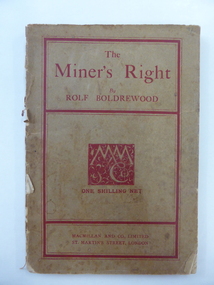
Book, The Miner’s Right, 1922
This book about the New South Wales goldfields was written by Rolf Boldrewood in 1890. It is retained because the author played a significant part in Warrnambool’s history. Rolf Boldrewood, the pen name of Thomas Browne, first came to the Warrnambool district in 1842, visiting the Bolden brothers’ property, Grasmere. He camped on the banks of the Merri River for about six months and described the area, including Warrnambool Bay, some years later in his book Old Melbourne Memories. In 1844 Thomas Browne established the property, Squattleseamere near Bessiebelle, north west of Portland. He remained there for ten years then moved to New South Wales. The last forty years of his life were spent writing and he became well-known for the classic Australian novel, Robbery Under Arms. This book is retained because it is a 19th century example of the writings of Rolf Boldrewood. He is important in Warrnambool’s early history as he was in the area in the early 1840s. His account of the area at that time is the most important one we have of the area that was later to be the site of the new settlement of Warrnambool.This is a soft cover book of 188 pages. The cover is brown with red edging and lettering and is partly detached from the binding. The spine is partly missing. The pages are dog-eared and there is some foxing. The text is printed in two columns to a page. Frank J. Donovanrolf boldrewood (thomas browne), bolden brothers in the warrnambool area, warrnambool history, the miners right -
 Warrnambool and District Historical Society Inc.
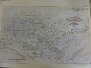
Map, Warrnambool 1859, Late 20th century (copy)
This is a copy of Bromfield’s 1856 map of Warrnambool and district. James Astley Bromfield was a pioneer settler in Warrnambool. He established a chemist’s shop in 1854, initially situated in Timor Street. He moved his shop to Liebig Street with a new building erected in 1875. Bromfield was a prominent resident of Warrnambool (Shire Councillor, Fire Brigade member, Cricket Club member, associated with horse racing etc). He was interested in preserving the history of Warrnambool and this map he produced in 1856 was an example of this interest.This is a copy only but this 1856 map is of prime importance as it contains the names of the original landowners of land in north Warrnambool and the surrounding district. It is a frequently-used resource by historians.This is a copy of a map of Warrnambool and its agricultural district published by James Astley Bromfield in 1856. The map is mounted on cardboard and has black printing on a white background. ‘Map of Warrnambool and its Agricultural District according to the Government Survey’s published by Astley Bromfield, Medical Hall, Warrnambool 1856, James Ferguson, Lithr., Melbne.’bromfield’s 1856, map, warrnambool and district -
 Warrnambool and District Historical Society Inc.
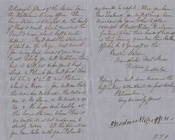
Letter, Frederick Griffin re moving to New Zealand
A letter written from Preston Estate telling of issues regarding conditions of station life. Preston station and Devil’s river are both in the vicinity of Mansfield in North East Victoria A letter which is typical of the time and as such has social and historical significance and interest.Blue paper hand written in black pen. Written front and back of paper. The signature is in a different hand.Signed Frederick Griffin preston estate, bostock, warrnambool -
 Kiewa Valley Historical Society
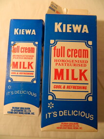
Milk Cartons - 2 litre & 1 litre, 2 litres - 1986. 1 litre - 1980's
The North-Eastern Dairy Company was established on 14th December 1892 as a butter factory and built in 1893. In 1928 a new butter factory was built and a milk products factory in 1952. Whole milk sales commenced in 1951, with pasteurised, homogenised milk in both bottles and cartons being sold in the 1980's. Devondale / Murray Goulburn was established in 1950. Cartons enabled the safe transportation and storage of milk. The North East Dairy Company enabled the dairy farmers in the Kiewa Valley to send their milk and milk products eg. cream to the factory at Kiewa. The factory bought its own cream carting vehicles during WW1. The 'full cream / homogenised / pastuerised / milk' is an example of the milk available in the 1980's as many different varieties of ingredients followed in later years.Blue, red & white waterproof sealed cardboard box used for storing fresh milk from the Kiewa factory 'Murray Goulburn'. The large box contains 2 litres and the smaller box, 1 litre. Each of the 4 faces have print - 2 have the title, 1 has advertising and 1 has instructions on how to store the carton of milk2 litre - Use by Date stamped at the top: 'Un Ed Oct 19' 1 litre - Use by Date stamped at the top: 'Ned Feb. 13'milk, murray goulburn, kiewa butter factory, kiewa milk products -
 Kiewa Valley Historical Society
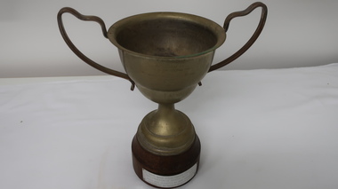
Trophy - Tawonga Football Club, 1947
"Mal Davidson had this cup. He made the new base from timber from the Bogong mess. He had Terry (Mc Innes) engrave the plate and then left it with us at the North Beauty Store where it was displayed. It created quite a lot of conversation over the years. During our pack up we discovered it on the shelf in the shed. " Wendy and Terry Mc InnesTawonga football club, Kiewa Hydro Electric Scheme, Bogong Mess, Mal Davidson, North Beauty Store; Wendy and Terry McInnesDull gold cup with a handle on opposite sides mounted on a wooden base. Cup is large with a neck between it and its base. Inscribed near the lip of the cup and an inscription attached to the bottom of the wooden base. Handles are large rising higher than the lip and are 'ear' shaped.On the gold cup: 'Presented by / J. Johnston / to / Tawonga Football Club / Premiers / 1947' On the wooden base: 'Base made from timber used in / Construction of Bogong Mess 1947. / Made and donated by Mal Davidson / Engraving by North Beauty Store.'football trophy, tawonga, j. johnston, bogong mess, kiewa hydro electric scheme, w and t mcinnes, north beauty store -
 Kiewa Valley Historical Society
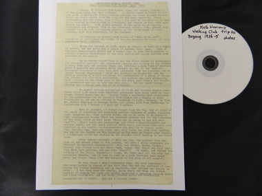
Diary Extract - Trip to Bogong High Plains Xmas 1934 & DVD photos, original diary 1934
The Melbourne Women's Walking Club enjoyed bush walking as a hobby travelling to the north east of Victoria, using pack horses and camping on a 9 day hike. One of the woman, 'Bill' describes each day in detail - what they did, where they went and what they saw giving an insight into walking and the Bogong High Plains in the mid 1930's before the Kiewa Hydro Electric Scheme opened up the area. The diary mentions a photo being taken by Mr Blackwell on the 9th day, New Year's Eve 'from a lovely bush track from which, looking back at intervals we got our final glimpse of Fainter. 5 miles from from our destination'.Historic: This extract from the diary of 'Bill', a member of the Melbourne Women's Walking Club gives an insight into walking in the mid 1930's and describes the Bogong High Plains as it was then before it was opened up with a road built during the Kiewa Hydro Electric Scheme. It describes the area in summer including the flora & fauna, cattle grazing & cattlemen, the huts, the gauges set up by the State Electricity Commission of Victoria, the people working up there, the weather and the lifestyle of the walking group - their food, duties, swimming etc.. Six double sided typed photocopied yellow pages describing the Melbourne Women's Walking Club trip to the Bogong High Plains at Christmas in 1934. Also one page photocopied of the programme for Year 1934-35 with an arrow pointing to the above trip and a page with a photocopied sepia photo of the "Melbourne Women's Walking Club / Bogong High Plains / Dec. 1934. DVD 12 photos of the trip arrow showing trip from Programme. Title of photo "Melbourne Women's Walking Club / Bogong High Plains / Dec. 1934melbourne women's walking club. bogong high plains. camping. pack horses. cattlemen's huts. -
 Kiewa Valley Historical Society
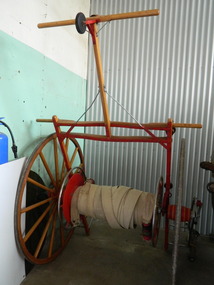
Fire Hose Reel, c1950s
The fire hose reel was purchased by the Fire Ladies' Auxiliary for the Mt Beauty S.E.C. Fire Brigade in the late 1950's for over 1000 pounds. Initially they competed with Bogong fire brigade as both were 'Industry' Fire brigades - both owned by the State Electricity Commission. Competition was at 2 levels - north east Victoria and state competitions involving rural and urban brigades with a difference in the equipment. Mt Beauty was/is an urban brigade whereas Tawonga is a rural brigade. Competition involved members to improve their skill, keep fit and was a very social occasion. After the Shire took over Mt Beauty township in 1961, the Fire Brigade ran by itself but soon became affiliated with the C.F.A. because of insurance and legal liability e.g.. enabling them to stop traffic or wreck buildings if required. The CFA were not happy with the Mt Beauty truck so a new one was obtained while the old one went to Bogong. Competitions gradually ceased as it was a young man's sport and young members had prior commitments. The reel was donated to the KVHS in the mid 1980's as it failed to be sold as it competed with new, cheaper, aluminium reels. The practice strip was located beside the fire station in Lakeside Avenue. This fire hose reel was used by the Mt Beauty Fire Brigade for demonstrations at competitions during the 1950's and 1960's. The Mt Beauty Fire Brigade Team won the competition in 1966 at Wangaratta. The score was close against the home team and was decided on a play off. The team benefitted by the man who wound the hose on allowing it to end up at the easiest height to handle when full of water and very heavy.The Mt Beauty Fire Brigade was an 'industry' fire brigade belonging to the State Electricity Commission of Victoria from the 1940's. It became a member of the Country Fire Authority in the early 1960's. During the 1950's and early 1960's members would compete with other local fire brigades in competitions against other brigades in the north east of Victoria using skills such as unwinding the hose off the reel and turning on the water in record time. The Mt Beauty Fire Brigade continues today as an urban fire brigade affiliated with the CFA.Varnished wooden cart reinforced by painted red steel frame. The wheels have 14 wooden spokes and steel around the outside of the wooden wheel. A long canvas hose is wound around a central winding cylinder. The cart has a wooden handle with a rubber jockey wheel at its end. There is a brass hose nozzle attached by a stainless steel frame on the outer side near one of the wheels.Each Reel: "Mt Beauty F.B." yellow print outlined in black with red background.fire hose. mt beauty fire brigade. country fire authority. fire reel. -
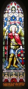 Christ Church Anglican Parish of Warrnambool
Memorial Window: Rev Canon Samuel McGEORGE, St. Michael
Samuel McGeorge was born in Belfast, Ireland in 1850. He was trained for the ministry at Moore College, Sydney. He was Vicar in Ararat for 10 years prior to coming to Warrnambool in 1899, to become the 3rd Vicar of the Parish. He was inducted on June 1st by Bishop Cooper. He showed a deep regard for the welfare and happiness of his parishioners. Christ Church progressed well under his charge. He suffered a very painful and distressing illness which forced him to obtain leave of absence from his clerical duties, but he continued to visit and encourage the sick and sorrowing. On December 4th 1904, Canon McGeorge opened the new Church and Sunday School in Koroit St, East Warrnambool, of which he had established. It was opened as a Mission Hall. It was to become St. George's and the first recorded service was on February 11th 1906. He preached his last sermon at Christ Church on Dec 4th before illness prevented him performing his duties. He resigned from the Vicariate shortly before his death in Warrnambool on December 16th, 1905. The stained glass window in the north wall of the second nave was a gift of many parishioners. Depicting St. Michael, it was erected in memory of Rev Canon McGeorge, and was unveiled by Dean Parkyn on December 23rd, 1906. His widow Mrs Emma McGeorge, remained an active church worker until her death in 1933. The Lych gate at the Koroit Street entrance was built with a bequest from her.Stained glass lancet window, north wall, north nave, depicting Saint Michael, the arch-angel Michael.Saint Michael. To the Glory of God and in memory of/ Samuel McGeorge Vicar 1899 - 1903 -
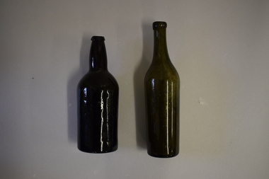 Warrnambool and District Historical Society Inc.
Bottles (2), Bottle, c. 1900
These two bottles were found by workmen building a new retaining wall on the north side of the Les O’Callaghan History House building in Gilles Street Warrnambool. The wall replaced one damaged beyond repair following a car accident in 2019. The building was erected in 1889 as the caretaker’s cottage in the Warrnambool Sea Baths complex (for most of its existence it had two swimming pools, a hot sea water baths building and a caretaker’s cottage). The water in the baths were pumped up from the ocean and, for the hot baths, heated on site. These baths were the municipal baths until the mid 1950s. The bottles may have originated from the one of the families residing in the cottage or from passers-by in the adjoining Merri Street or from patrons of the baths. They appear to be over 100 years old but there is no way the ownership of the bottles can be established.These bottles are of interest as archeological finds after repair works to the Les O’Callaghan History House. .1 A dark green (or black?) glass bottle with a hollowed out concave base, no stopper and a slightly chipped rim on the top. The bottle is stained inside. .2 A green glass bottle with a hollowed out concave base, a moulded top with no stopper and an elongated neck. The bottle is stained inside. warrnambool & district historical society, heritageworks warrnambool, les o’callaghan history house, warrnambool, history of warrnambool -
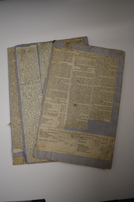 Warrnambool and District Historical Society Inc.
Document: Cuttings, Warrnambool Steam Packet Company, C 1890
THis collection of cuttings relates to the Warrnambool Steam Packet Company.The Warrnambool Steam Packet Company was established in 1868 when capital was raised with 2000 shares at a value of five pounds each.It was established to provide passenger, accommodation and a large stock and freight service between Warrnambool and Melbourne.. At the time Stephen Henty was operating three steamers along the coast and at the prospect of losing his Warrnambool trade with the establishment of the new Warrnambool company, he sold one of his steamers , the Edina in March 1868. The first five directors elected were F P Stevens, J G Crammond, WW Jamieson, R B Paterson and George Wood. Fares were from one to three pounds and freight was 17 shillings per ton.The steamers connected with coaches from the north of Warrnambool as far as Hamilton. The cuttings record the financial position of the company for the first ten years. This collection of cuttings is valuable as a research item as it documents the development and operation as well as many of the stake holders in one of Warrnambool's earliest shipping companies. The cuttings are from a range of papers including The Warrnambool, Examiner, The Warrnambool Advertiser and the Argus.Ledger book with blue pages which is lacking the cover. It contains a number of cuttings which relate to the Steam Packet Company.Dated on first page: Monday November 1st 1869. Most of the cuttings are dated and some are from the Examiner. the Advertiser and Warrnambool Standard.warrnambool, warrnambool steam packet company, edina -
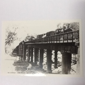 Port of Echuca
Photograph, Original photo C.1910. Copy 1984
This photograph comes from the Dowell collection. Related to P000202. At the turn of the 20th century, the railway line carried produce from southern New South Wales and the Riverina to Melbourne. Goods trains were a very important mode to transport to our region and industrialisation of Echuca. Photograph of the Murray bridge at Echuca at low river with a goods train crossing the bridge. Image is seen from bank facing north from Echuca.Recto :"MURRAY BRIDGE Echuca"; Verso: "C.1910" "Low river"dowell collection, murray river bridge , echuca, murray bridge, echuca, steam engine goods train, railway, transportation, industrialisation -
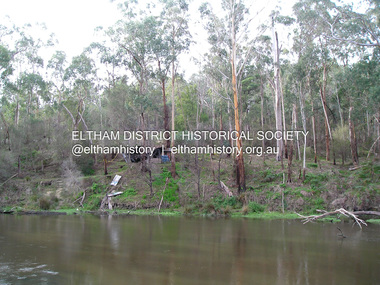
 Eltham District Historical Society Inc
Photograph, Fay Bridge, Old footbridge, 195 Laughing Waters Road, Eltham, n.d
This old footbidge is situated close to the shack that Gordon Ford built on the Yarra at Laughing Waters Road. Bernie Bragg also used to live there for a period of time. Gordon Ford and photographer Sue Winslow were married in 1965. They set up home in an old log cabin on the property Gordon had purchased in 1954 on Laughing Waters Road. Situated between the Yarra River and Overbank Road, Gordon had built a small mud-brick shack on the river and a pontoon. Over the decades the shack has been locally referred to as “the love shack”, the “rooting shack” or simply “Gordon’s shack”. Gordon and Sue commissioned local builder Graeme Rose to do a wattle and daub renovation and extension to the old log cabin on the north side of Laughing Waters Road. The work had only just been completed in 1965 when a bushfire swept through the area and destroyed the cabin. Gordon and Sue relocated to his property, Fulling, in Pitt Street, Eltham. In 1970 work started on a new house at the Laughing Waters property. Originally known as the Banana House, it is now known as Boomerang. Designed by Alistair Knox, the mud-brick house includes iron window grilles made by Matcham Skipper that puncture the curved mud walls. The grilles were made from ‘off-pressings’ from the Sidchrome tool works in Heidelberg. Gordon, Sue and family moved into the house in 1972. Their marriage fell apart and Sue moved to Sydney with the children around the same time Gordon commenced building Birrarung just below Boomerang on the Laughing Waters Road block. After the Fords moved out, Boomerang it was rented out to various share households of students, musicians, artists and environmentalists for twenty-four years. Gordon Ford sold Birrarung and Boomerang to Melbourne Water in 1999. The Laughing Waters Artist in Residence Program was developed as a partnership between Parks Victoria and Nillumbik Shire Council. Boomerang was deemed unfit for habitation so was used as a day studio only. By 2001 Boomerang was in a poor state of repair and by 2002 the last artist in residence was to use the house as a studio. Nillumbik Shire Council had been granted funds from the Melbourne Community Fund to restore both Boomerang and Birrarung but it was apparent in early 2003 that the funds would be insufficient to restore both houses. Boomerang was infested with termites which presented a risk to any occupants and so the decision was made to close Boomerang and concentrate funding on Birrarung. Boomerang was fenced off for safety and to prevent intrusion and remains ‘caged’ today (2023). However, it is readily apparent the property has been occupied by squatters over the years. By 2023 it was clear that the squatters had abandoned the property and sections of the roof structure have given away in some areas and collapsed internally. For a more in-depth description and history of the property and that of Gordon and Sue Ford, see Jane Woollard's book, "Laughing Waters Road; Art, Landscape & Memory in Eltham" published 2016.fay bridge collection, bernie's hut, birrarung, footbridge, gordon ford, gordon's shack, laughing waters road, love shack, yarra river -
 Eltham District Historical Society Inc
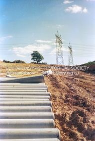
Photograph (Item) - Print, Angela Wall, New Subdivision - Reynolds Road, 1988
Angela Wall 1988 Entrant No. 129 Ref: Series 34, Items 30, 101, 102 SHIRE OF ELTHAM COMMUNITY PHOTOGRAPHIC SURVEY Photography is an artform which many of us practice, sometimes purely for artistic pursuit, sometimes to record the people and events in our lives. In 1988, as part of a local Bicentennial project, the Shire of Eltham conducted the Eltham Community Photographic Survey. Up to 100 entries were to be selected by a panel of photographers for entry into the Eltham Photographic Survey Exhibition. Entries had to be submitted by May 13, 1988. Entrants whose images were selected for the exhibition were contacted and requested to further submit an entry form providing entrant’s name, area of residence, age, and proposed captions. These details were then used to produce labels for the exhibition mounts. Where negatives had not been supplied, these were requested to support the display of printed enlargements mounted on 10” x 8” cardboard. The mounted prints were made available post exhibition for sale at $8.50 each for colour prints and $7.00 for B&W prints. Residents in the Shire were invited to collect a free roll of film and take a photograph of what they either liked or did not like about the area. A total of 160 entrants submitted multiple entries for the exhibition. Of those selected for exhibition, entrants ranged in age from 9 to 70 years. All custom colour and black and white printing for the exhibition was completed by Wattle Studios of Eltham. The Eltham Photographic Survey was jointly auspiced by the Shire of Eltham and Wattle Studios, of 953 Main Road, Eltham. The project was greatly assisted by: • David McRitchie, Media Studies Lecturer Victoria College, Rusden Campus. • Ian and Annette Toohill of Wattle Studios • Tracy Naughton, Eltham Community Arts Officer • Neville Emerson Pty. Ltd. • Superior Press, Eltham • Kodak Australasia Pty. Ltd. • Agfa Gevaert Ltd. • Townsend Colourtech Pty. Ltd. • The Australian Bicentennial Authority • Eleanor Bowers, Secretary, Eltham Arts Council The exhibition was placed on display in the Woolworths Arcade, Eltham between Monday June 6th and Saturday June 11, 1988. It was also intended to hold the exhibition at a venue in the Shire’s North Riding from Monday, June 20 to Friday June 24. It was then displayed at the Were Street Theatre, Montmorency from Friday, June 24 to Thursday, July 7. Series 34: Eltham Community Photographic Survey 1988 - Prints & Documentation Series consists of 117 photographs of Shire scenes taken by members of the community. Items I - 41 are larger photographs mounted on card, which were exhibited. Items 42 - 117 are unmounted copies, alternative takes and other entries. Corresponding negatives contained in Series 35: Eltham Community Photographic Survey 1988 – Negatives which consists of 267 colour and B&W negatives and one colour slide of Shire scenes taken by members of the community. The negatives are arranged by the entrant number of the photographer. The Eltham Community Photographic Survey collection is significant to the local community as it was curated by the local community - ordinary people of all ages - representing what they liked and did not like in the area where they lived. It represents an unfiltered representation of the Shire of Eltham as it was in 1988. It also represents one of many projects as part of the national programme of events and celebrations to commemorate the bicentenary. It is a time capsule of life in the 1980s of this urban and rural municipality in Melbourne's north. Front: Entrant No. and name on printed label Rear: Entrant No., name and address on printed label; also 'Series 34' and the 'Item No.' in pencilshire of eltham archives, bicentennial project, eltham, eltham community photographic survey, eltham photographic survey exhibition, series 34, series 35, angela wall, film - kodak ga 100 5095, housing estate, power transmission lines, real estate development, research (vic.), reynolds road, scan - 35mm negative, subdivison lots -
 Eltham District Historical Society Inc
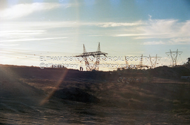
Photograph (Item) - Print, Sean Brady, Untitled (New Subdivision), 1988
Sean Brady 1988 Entrant No. 145 Ref: Series 34, Items 33, 34, 105, 106 SHIRE OF ELTHAM COMMUNITY PHOTOGRAPHIC SURVEY Photography is an artform which many of us practice, sometimes purely for artistic pursuit, sometimes to record the people and events in our lives. In 1988, as part of a local Bicentennial project, the Shire of Eltham conducted the Eltham Community Photographic Survey. Up to 100 entries were to be selected by a panel of photographers for entry into the Eltham Photographic Survey Exhibition. Entries had to be submitted by May 13, 1988. Entrants whose images were selected for the exhibition were contacted and requested to further submit an entry form providing entrant’s name, area of residence, age, and proposed captions. These details were then used to produce labels for the exhibition mounts. Where negatives had not been supplied, these were requested to support the display of printed enlargements mounted on 10” x 8” cardboard. The mounted prints were made available post exhibition for sale at $8.50 each for colour prints and $7.00 for B&W prints. Residents in the Shire were invited to collect a free roll of film and take a photograph of what they either liked or did not like about the area. A total of 160 entrants submitted multiple entries for the exhibition. Of those selected for exhibition, entrants ranged in age from 9 to 70 years. All custom colour and black and white printing for the exhibition was completed by Wattle Studios of Eltham. The Eltham Photographic Survey was jointly auspiced by the Shire of Eltham and Wattle Studios, of 953 Main Road, Eltham. The project was greatly assisted by: • David McRitchie, Media Studies Lecturer Victoria College, Rusden Campus. • Ian and Annette Toohill of Wattle Studios • Tracy Naughton, Eltham Community Arts Officer • Neville Emerson Pty. Ltd. • Superior Press, Eltham • Kodak Australasia Pty. Ltd. • Agfa Gevaert Ltd. • Townsend Colourtech Pty. Ltd. • The Australian Bicentennial Authority • Eleanor Bowers, Secretary, Eltham Arts Council The exhibition was placed on display in the Woolworths Arcade, Eltham between Monday June 6th and Saturday June 11, 1988. It was also intended to hold the exhibition at a venue in the Shire’s North Riding from Monday, June 20 to Friday June 24. It was then displayed at the Were Street Theatre, Montmorency from Friday, June 24 to Thursday, July 7. Series 34: Eltham Community Photographic Survey 1988 - Prints & Documentation Series consists of 117 photographs of Shire scenes taken by members of the community. Items I - 41 are larger photographs mounted on card, which were exhibited. Items 42 - 117 are unmounted copies, alternative takes and other entries. Corresponding negatives contained in Series 35: Eltham Community Photographic Survey 1988 – Negatives which consists of 267 colour and B&W negatives and one colour slide of Shire scenes taken by members of the community. The negatives are arranged by the entrant number of the photographer. The Eltham Community Photographic Survey collection is significant to the local community as it was curated by the local community - ordinary people of all ages - representing what they liked and did not like in the area where they lived. It represents an unfiltered representation of the Shire of Eltham as it was in 1988. It also represents one of many projects as part of the national programme of events and celebrations to commemorate the bicentenary. It is a time capsule of life in the 1980s of this urban and rural municipality in Melbourne's north. Front: Entrant No. and name on printed label Rear: Entrant No., name and address on printed label; also 'Series 34' and the 'Item No.' in pencilshire of eltham archives, bicentennial project, eltham, eltham community photographic survey, eltham photographic survey exhibition, series 34, series 35, scan - 35mm negative, film - kodak ga 100 5095, housing estate, power transmission lines, real estate development, sean brady, subdivison lots -
 Eltham District Historical Society Inc
Newspaper - Advertising, The Advertiser, Nillumbik Festival In Pictures; pp5-7, November 14, 1995
The Nillumbik Festival was introduced as a replacement for the Eltham Festival following the disbandment of Eltham Shire Council in December 1994 and the creation of Nillumbik Shire Council. It was an attempt to draw away from Eltham and be more inclusive of the wider communities in Nillumbik. However other local communities had their own festivals and the concept of a Nillumbik Festival was never widely accepted by the community and it shortly reverted back to the Eltham Fesitval in 1997. Page 5 Photo: Acting Sen-Sgergeant Paul MacNicholl of Eltham Police with Jamie-Lee Teagley and friends at the Nillumbik Festival on Saturday Page 6 Photos: Nillumbik Chief Don Cordell with Parade leader Jock Read & Lofty Roma O'Callaghan and Brian McKean of Plenty Valley FM - 88.6 Artist Ray Macminn of Diamond Valley arts Society exhibition The Eastside Jazz Band lead the way in Saturday's Nillumbik Festival Eltham Football Club fellas fly the flag for the Panthers in Main Road Eltham Lionesses Marcia Whitely, Peggy Lear, June Cook & Kath Elliott ALP's Sherryl Garbutt, Harry Jenkins, Sig Jorgensen and Jenny Macklin Diamond Valley Arts Society's Don Cook paints with oils on Saturday It's amaxing who'll you'll meet at the Nillumbik Festival Page 7 Photos: Eltham MLA Wayne Phillips with Jaga Jaga candidate Michelle Penson Greens candidate Julie Coulston with Geraldine Ryan at Knox Park The Anti Ring Road Organisation march on, you guessed it, Main Road Lower Plenty Primary School had an imaginative display in the Parade The Melbourne Kyokushin Club show their defence skills on Saturday Brian Harvey of Diamond Valley Sports Complex at the Fitness Expo Michael Jerrard and president Trevor Taylor of Greensborough- Diamond Creek Apex Jock Kyme drives the Democratic Nillumbik Association float on Main Road Page 8: Letter: Time for a new Eltham Festival by Sigmund JorgensenNewsprint1995, eltham festival, nillumbik festival, 1st eltham brownies, 1st eltham scouts, alistair knox park, allwood house belly dance, anti ring road organisation (arro), brian mckean, circus of chaos, democratic nillumbik association, diamond valley people for nuclear disamament, don cordell, drum group, eastside jazz band, eltham cfa, eltham community health centre, eltham east primary school, eltham fire brigade, eltham football club juniors, eltham north primary school, eltham primary school, eltham ses, eltham south primary school, eltham steam and stationary engine society, grand parade, harry jenkins, jean austin, jenny macklin, jock read, john cust, john huf, julie coulston, kevin abbott, kevin austin, lofty (horse), lower plenty primary school, lyn allison, main road, melbourne kyokushin karate school, montmorency garden club, montmorency south primary school, montsalvat coachlines, nillumbik commissioners, nillumbik garden club, north warrandyte fire brigade, panther place, peter burton, plenty valley 88.6 fm, pryor street, rats of tobruk memorial pipes and drums, research fire brigade, research primary school, robert guy, roma o'callaghan, sheryl garbutt, sigmund jorgensen, tim newhouse, wayne phillips m.p., woodridge pre-school, diamond valley vineyards, dutch social club, edendale community farm, eltham bowling club, eltham eagles in-line hockey, eltham football club, eltham rugby football club, eltham vineyards, ginger garlic, kingstan berries, silvie's delectables, vili's pies, wycliffe bible translators -
 Eltham District Historical Society Inc
Photograph - Digital Photograph, Alan King, Original Kangaroo Ground Primary School No. 2105 building, Eltham-Yarra Glen Road, Kangaroo Ground, 28 December 2007
Kangaroo Ground's first school began in 1851 with 22 pupils from the district's ten families. It was a single room school located further south on the site, which also served as a Presbyterian church. The first teacher was Andrew Ross. The school building was used as a Post Office between 1854 and 1858 and during 1857 also served as a Court of Petty Sessions. With a growing farming community, a new building was warranted and the original Sate School No. 352 was closed and a new building, State School No. 2105 was oipened October 1, 1878. A residence for Head Teacher Henry Wallace School was erected in 1879 attached to the left of the school building. That residence is now home to the Andrew Ross Museum, which opened in 1993. Covered under Heritage Overlay, Nillumbik Planning Scheme. Published: Nillumbik Now and Then / Marguerite Marshall 2008; photographs Alan King with Marguerite Marshall.; p35This collection of almost 130 photos about places and people within the Shire of Nillumbik, an urban and rural municipality in Melbourne's north, contributes to an understanding of the history of the Shire. Published in 2008 immediately prior to the Black Saturday bushfires of February 7, 2009, it documents sites that were impacted, and in some cases destroyed by the fires. It includes photographs taken especially for the publication, creating a unique time capsule representing the Shire in the early 21st century. It remains the most recent comprehenesive publication devoted to the Shire's history connecting local residents to the past. nillumbik now and then (marshall-king) collection, kangaroo ground, eltham-yarra glen road, kangaroo ground primary school no. 2105, kangaroo ground state school, state school no. 2105 -
 Eltham District Historical Society Inc
Photograph - Digital Photograph, Alan King, Wellers Restaurant, 150 Eltham-Yarra Glen Road, Kangaroo Ground, 23 January 2008
Originally Wellers Hotel, it was constructed by Edward Weller in 1872. Following his death in 1883 it was taken over by his widow, Mary Weller. The hotel was delicensed in 1909 and converted to a private residence. Around 1920 William Pitman bought the property, succeeded by his son Vernon who coined the term Pittman's Corner. Vernon and Isabel Pitman owned the house form 1945-1973. Following Vernon's death, Isabel remained there till her death in 1983. The property was converted to a restaurant in 1984 by owners Robert and Kath Hendry who undertook extensive renovations in 1988. Shawn and Stephanie Wolfe purchased the property from the Hendrys in 2003 and introduced live entertainment with many famous bands and entertainers from the 1960s, 1970s and 1980s performing there, including James Reyne, Daryl Barithwaite, Brian Cadd and Billy Thorpe. In 2014 the Wolfe's sold the property and the entire contents were sold at auction. New (local ) owners Gregory Anderson, Craig Jones and Steve Gist refurbished the property and relaunched it as Fondata 1872 in 2017. Covered under Heritage Overlay, Nillumbik Planning Scheme. Published: Nillumbik Now and Then / Marguerite Marshall 2008; photographs Alan King with Marguerite Marshall.; p87This collection of almost 130 photos about places and people within the Shire of Nillumbik, an urban and rural municipality in Melbourne's north, contributes to an understanding of the history of the Shire. Published in 2008 immediately prior to the Black Saturday bushfires of February 7, 2009, it documents sites that were impacted, and in some cases destroyed by the fires. It includes photographs taken especially for the publication, creating a unique time capsule representing the Shire in the early 21st century. It remains the most recent comprehenesive publication devoted to the Shire's history connecting local residents to the past. nillumbik now and then (marshall-king) collection, eltham-yarra glen road, fondata 1872, kangaroo ground, wellers restaurant, billy thorpe, brian cadd, craig jones, daryl barithwaite, edward weller, gregory anderson, hotels, james reyne, kath hendry, mary weller, restaurants, robert hendry, shawn wolfe, stephanie wolfe, steve gist -
 Eltham District Historical Society Inc
Document - Folder, Masefield, Bert and Ethel
Bert Masefield's parents came from Lancashire to Surrey Hills, his education ending because of the depression when he went to work at an orchard at Hastings. When his father list his job as a cabinet maker, he bought an orchard at Cottlesbridge and Bert joined them, ploughing with a horse. He met and married Ethel Smith who had grown u at Panton Hill; her great grandparents Sarah and Samuel Smith came from Lancashire where they had a cotton mill and iron foundry, settling at Smith Gully between Panton Hill and St Andrews. Their son Edwin married Louisa Purcell whose parents owned the Caledonie Hotel at Smiths Gully; they had 12 children and settled on a property in Cherrytree Road. Son Edwin left Panton Hill school aged 11 in 1885 and worked with his father and uncle fencing the family property. Edwin had nine children, Ethel being the seventh. Aged 14, she gained a scholarship to Stotts Business College. Berth and Ethel, when they married, bough a property in Cherrytree Road. In 1941 Bert, a ham radio enthusiast, joined the RAAF as a radio mechanic, serving in Townsville and New Guinea until 1945. Over time, they subdivided their property. Bert worked for ten years as property officer for Eltham Shire Council; his work included coverting Three Chain Road (or Gumtree Road) into a huge firebreak. Now retired, Bert spends time speaking with radio operators around the world and the couple are involved with sports including the Montmorency Bowling Club; they were foundation members of the Hurstbridge Bowling Club. Marjorie North (nee Cooper) was 14 when her family moved from the city to Montmorency when the railway station was first built in 1923. Marjorie described her memories of Montmorency at that time. She and sister Connie were keen tennis players, playing at Greensborough. By 1927, they had arranged, though shire engineer Ben Johnson, to rent land from the Council for 10 pounds a year; Mr Paragreen levelled the land. The club held a dance every three weeks in a school room with piano for music. She won the singles, doubles and mixed doubles championships in 1929 at the first championship. Contents Newspaper article: "Round the world on radio waves," Diamond Valley News, 30 September 1986, outlines Bert and Ethel Masefield's lives. Newspaper article: "Stalwart recalls the early days," Diamond Valley News, 30 September 1986, outlines Bert and Ethel Masefield's lives.Newspaper clippings, A4 photocopies, etcbert masefield, elthel masefield, ethel smith, cherrytree road panton hill, samuel smith, sarah smith, smith gully victoria, caledonie hotel smiths gully, stotts business college, montmorency bowling club, hurstbridge bowling club, eltham shire council, edwin smith, louisa purcell, parragreen of para road, ben johnson, montmorency tennis club -
 Eltham District Historical Society Inc
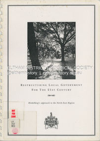
Document (Item) - Book, City of Heidelberg, Restructuring Local Government for the 21st Century: Heidelberg's approach to the North East Region, February 1994
The City of Heidelberg's Council first preference is "no change" [to municipal restructure] but if this option is unacceptable, the Council would prefer to form larger municipality/municapilites involving the exisitng City of Heidelberg and the Shires of Diamond Valley and Eltham. This report includes an exective summary, Introduction, A Brief History, Heidelberg and its [municiapl] neighbours now, opportunities for restructure, detailed analysis and preferred structure. Includes fold out maps.This report by the City of Heidleberg is a significant local contribution in the consultation leading to a significant change to local government in Victorian when, in 1994 the Kennett State government restructed local government. The reforms dissolved 201 Councils and created 78 new councils through amalgamations. In suburban Melbourne 53 municipalities were reduced to 26. The City of Heidelberg was amalgamated with parts of the Shire of Eltham and Diamond Valley to become the City of Banyule.annexation, council amalgamation, local government -
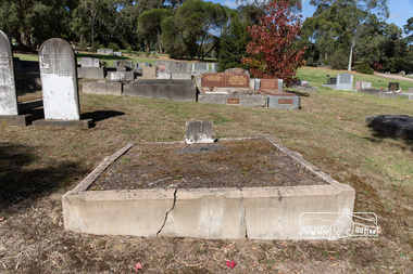 Eltham District Historical Society Inc
Photograph, Peter Pidgeon, Grave of Sarah and Phillip Shillinglaw, Eltham Cemetery, Victoria, 5 April 2021
Philip Shillinglaw and his wife Sarah came to Eltham in 1882. Their property "Wattle Brae" originally encompassed present-day Eltham Central Park and part of Eltham Library, extending north to include Andrew Park and the site of the railway station. An early photo shows that much of it was planted for crops. They also had cows; in 1913 Philip wrote to the local paper complaining about an earlier report that one of them had been killed on the railway line. "I give an emphatic denial to the report. It is not true." Their house Shillinglaw Cottage (built by George Stebbings) still exists, though it was moved with funding from local residents in 1963-64 when faced with demolition to make room for new Council Offices. Philip was actively involved with the Methodist Church as preacher, Church Steward and Sunday School teacher. A Sunday School picnic and a sports carnival were held on his paddock. Eight of his children attended Eltham Primary School. In 1908 he ploughed part of the schoolyard (possibly for use as a garden) free of charge. When Philip died in 1914, his funeral was described as one of the largest ever seen in Eltham. He and Sarah are buried in Eltham Cemetery. In Loving Memory of Sarah Ann Shillinglaw Died 10th Dec. 1891 Also Phillip Loved husband of above Died 18th Aug. 1914 Sweet BestBorn Digitaleltham cemetery, gravestones, phillip shillinglaw, sara ann shillinglaw -
 Eltham District Historical Society Inc
Photograph - Colour Print, Belle Vue, Livingstone Road, Eltham, c.2015
Belle Vue property in Livingstone Road, Eltham was once owned by Society member Jo McCormick. Jo was a valued member of our committee and dear friend of many of our members until her death in 2009. Belle Vue is the farmhouse of a property that is now a significant part of suburban Eltham, just a short distance north of the town centre. Originally purchased by pioneer Eltham farmer Henry Stooke, the present-day old farmhouse sits within an extensive suburban residential area. The history of the property is largely based on a heritage assessment prepared by consultant Lorraine Huddle for Nillumbik Shire Council. Additional information from our Society records reveals Belle Vue farm comprised about 56 ha (140 acres) extending northerly from the northern boundary of Holloway’s 1851 Little Eltham subdivision. On the present day map the southern boundary was just north of Elsa Court and Grove Street. The western boundary was the Diamond Creek and extended northerly to Main Road where it turns easterly towards Research. It was traversed by the main road to Kangaroo Ground and beyond and from 1912 by the railway to Hurstbridge. From 1895 the farm was owned by William Williams and his wife Mary Ann. In 1914 -15 they built a new house now known as Belle Vue. They sold the land in 1920 and residential subdivision began soon after that. Belle Vue remains today on a substantially subdivided and very much reduced size residential lot in Livingstone Road. The house and many old trees on the site were subject to a heritage overlay under the Nillumbik Planning Scheme. Despite that overlay, the development and subdivision of the original land resulted in most of the heritage listed trees being removed. belle vue, eltham, livingstone road -
 Eltham District Historical Society Inc
Photograph - Digital Photograph, Marguerite Marshall, Avenue of Honour, Main Road, Eltham, 20 April 2008
The suggestion of an Avenue of Honour may have been originally put forward by Lady Irvine who was a member of the Welcome Home Committee. The Avenue of Honour was established to memorialise all those from Eltham who enlisted (some of whom were still fighting overseas at the time), similarly as the Shire of Eltham (Soldiers) Memorial Park was in tribute to all from the Shire who enlisted. The twenty-seven names of those killed from Eltham were engraved on the Eltham War Memorial Obelisk unveiled in 1919 at the corner of Main Road and Bridge Street. From an article in the Heidelberg News and Greensborough, Eltham and Diamond Creek Chronicle, September 22, 1917, p. 2, it was reported: Some few weeks ago a public meeting was held in the Eltham Rechabite Hall for the purpose of forming a committee to make necessary arrangements for the return of our brave lads from the front, with the result that the following officers were elected, viz., Sir William Irvine. president; Cr. R. D. Taylor, vice-president; Rev. T. W. Sapsford, secretary; Mr R. E. Gilsenan, treasurer; with a very strong committee of local residents. Lady Irvine then suggested that it would be nice to plant an Avenue of Honor, which was carried out in a very cheerful and spirited manner on Saturday afternoon. Cr Taylor and Mr R. E. Gilsenan occupied themselves during the fore-forenoon in getting the lining-out and other preliminaries ready, but shortly after one o'clock the willing workers could be seen wending their way towards the township, with picks, shovels. &c., on their shoulders, and in a very short time the gang at work was in appearance a very lively and pretty sight, the only thing that was missing was the camera, to have had a few snapshots taken. A little after 3 o'clock Sir William and Lady Irvine, and Mr W. Gray and family, arrived by motor. Cr Taylor then explained that their object in gathering together so hurriedly to plant the avenue was on account of the lateness of the season, and being offered 100 trees, free of charge, by Cr. Wm. G. Gray; of Allwood Nursery, Hurst's Bridge (for which the committee are deeply grateful to him and the public highly appreciate his generous offer). Sir Wm. Irvine then spoke at some length on the ravages of this cruel war, and the good that must result therefrom in bringing all closer together; he also referred to our brave lads who were fighting for us, and thought it was for those at home to show their appreciation by planting the Avenue of Honor. Lady Irvine thou proceeded to plant the first tree, which was an English oak: Sir William following by planting a Spanish chestnut; and Mrs W. G. Gray a sycamore. After that the gathering refired to the entrance of Mr R. E. Gilsenan's green paddock to partake of refreshments, which the ladies had kindly provided for the willing band of workers. Work was again taken to in earnest, and the planting finished, all being satisfied that they had done good work. At the Eltham Shire Council’s monthly meeting held May 6, 1918, Cr. Gray promised to give Council £20 to £25 worth of trees if the Council would plant and guard them. His desire was that a tree be planted in the name of every soldier lad who has gone to the front. Each tree was later adorned with a brass plaque with the name of a soldier and a wooden tree guard placed around them. Over the years many trees died, and following roadworks were replanted on a new alignment. Nillumbik Shire Council is continuing this process of replanting trees in a new alignment to move them away from overhead power lines and to clear the VicRoads reserve. Covered under Heritage Overlay, Nillumbik Planning Scheme. Published: Nillumbik Now and Then / Marguerite Marshall 2008; photographs Alan King with Marguerite Marshall.; p119This collection of almost 130 photos about places and people within the Shire of Nillumbik, an urban and rural municipality in Melbourne's north, contributes to an understanding of the history of the Shire. Published in 2008 immediately prior to the Black Saturday bushfires of February 7, 2009, it documents sites that were impacted, and in some cases destroyed by the fires. It includes photographs taken especially for the publication, creating a unique time capsule representing the Shire in the early 21st century. It remains the most recent comprehenesive publication devoted to the Shire's history connecting local residents to the past. nillumbik now and then (marshall-king) collection, avenue of honour, main road, eltham -
 Eltham District Historical Society Inc
Photograph - Digital Photograph, Alan King, Shire of Eltham War Memorial, Kangaroo Ground, 28 January 2008
The Eltham Shire War Memorial, a tower of remembrance, was built with public donations to commemorate the memory of the fallen soldiers from the shire who enlisted in the 1914-1918 war. The tower is reminiscent of the peel-towers or watchtowers that lined the English-Scottish border from the mid 14th century to around 1600 and is constructed from locally quarried stone. This uncommon and picturesque war memorial, which affords an excellent view of the surrounding district was unveiled by His Excellency the Governor-General (Lord Stonehaven) on November 11, 1926. In July 1922 a deputation of returned soldiers from Panton Hill, presumably the Panton Hill branch of the Returned Sailors and Soldiers Imperial League of Australia (RSSILA), proposed to Eltham Shire Council that the monument should be a cairn of local stone “sufficiently high to form a prominent and conspicuous landmark, and crowned with some suitable device”. Eltham Shire Councillor and President of the Panton Hill branch of the RSSILA, Basil Hall, was credited with being the first to suggest a tower, and with organising a Memorial Park committee to raise funds for the monument in the Memorial Park. A meeting for those interested in the establishing a War Memorial monument in the park was held in January 1924 and the Eltham Shire War Memorial League was formed for this purpose. It appears that the broad and rounded cairn that had been recently built was considered by the League a temporary affair, and not the substantial cairn-as-monument, sufficiently high to form the conspicuous landmark, which had been envisaged by the Panton Hill RSSILA. A design competition was held for the monument. The chairman of the League, Councillor Basil Hall, suggested that the site of the memorial in Kangaroo Ground would lend itself to something rugged, instead of polished stone. By April 1924 thirty designs for a memorial had been received from which three designs were selected and of those, the design by the shire engineer Mr McCormack, for a 70ft tower suitable for construction in rough stone, was chosen. Artist Harold Herbert suggested that a peel tower-like design reminiscent of those along the English-Scottish border would be fitting for the site. Herbert drew up a rough sketch that was approved of, and later, Melbourne architect Percy Meldrum volunteered to draw up the design from sketch to architectural drawings. By January 1925 the Soldiers’ Memorial League had adopted Meldrum’s design for a 50ft high tower. Meldrum had also offered his design and supervision of construction free of charge. The Shire provided the stone to the builders, which was a gift quarried from land owned at Kangaroo Ground by Dr Ethel and Professor William Osborne The Shire of Eltham War Memorial, a tower of remembrance, and honour board were unveiled on November 11, 1926, by the Governor General Lord Stonehaven. At this stage a temporary honour roll was painted on the panels on either side of the tower entrance. In September 1930 bronze plates were added above the portal with the names of men who fell in the 1914-18 war. On November 16, 1951, the Governor of Victoria, Sir Dallas Brooks re-dedicated the war memorial tower and unveiled the names of men who gave their lives in the 1939-45 war. Two additional bronze plaques which recognise service in the armed conflicts of Korea, Borneo, Malaya, and Vietnam were unveiled November 11, 2001, by the Governor of Victoria, John Landy, A.C., M.B.E. The tower was first used for fire spotting activities following the Black Friday bushfire in January 1939 in response to a request from Mr R.D. Ness, secretary of the Kangaroo Ground bush fire brigade, who asked Council that the tower be used as an observation tower for detecting bush fires, and asked Council to arrange a telephone to be installed. It was suggested that if the Shire were to appoint a caretaker for the Memorial Park, his duties could also include raising the alarm in the event of a fire. Later in 1939 Council applied for a radio transmitter, which the Forestry Commission planned to install at vantage places throughout the state. The first dedicated fire spotter appointed from December1948, was Mr Smith of Warrandyte. A prefabricated glazed cabin was installed in 1974, which involved the removal of the original stone structure around the rooftop exit door. A new fire spotting cabin, which included the latest technology, was installed soon after the 2009 Black Saturday fires and is manned by CFA personnel on high fire danger days. Covered under Heritage Overlay, Nillumbik Planning Scheme. Published: Nillumbik Now and Then / Marguerite Marshall 2008; photographs Alan King with Marguerite Marshall.; p123This collection of almost 130 photos about places and people within the Shire of Nillumbik, an urban and rural municipality in Melbourne's north, contributes to an understanding of the history of the Shire. Published in 2008 immediately prior to the Black Saturday bushfires of February 7, 2009, it documents sites that were impacted, and in some cases destroyed by the fires. It includes photographs taken especially for the publication, creating a unique time capsule representing the Shire in the early 21st century. It remains the most recent comprehenesive publication devoted to the Shire's history connecting local residents to the past. While published in the book in black and white, this collection features the original colour digital photographs. nillumbik now and then (marshall-king) collection, garden hill, kangaroo ground, memorial park, shire of eltham war memorial -
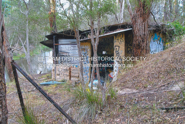
 Eltham District Historical Society Inc
Photograph - Digital Photograph, Jim Connor, Boomerang House, 195 Laughing Waters Road, Eltham, 7 September 2013
Laughing Waters Walk, 7 Sep 2013 This Society excursion was a follow up to the Laughing Waters Story told to us by Jane Woollard at our Annual General Meeting in March 2013. It involved a walk commencing from the corner of Laughing Waters and Overbank Roads along Laughing Waters Road to its eastern end and returning partly over the same route - a total distance of about 2.5km. On the way we visited the two artist in residence properties, River Bend and Birrarung, to view the houses on them that are associated with Alistair Knox, Gordon Ford and others in the local mud brick and artistic community. We also able to walk around the derelict ruin which was once home to Gordon and Sue Ford, Boomerang House. An unexpected afternoon tea was offered to us by the artists in residence at Birrarung House and we had a brief opportunity to view inside the house. Gordon Ford and photographer Sue Winslow were married in 1965. They set up home in an old log cabin on the property Gordon had purchased in 1954 on Laughing Waters Road. Situated between the Yarra River and Overbank Road, Gordon had built a small mud-brick shack on the river and a pontoon. Over the decades the shack has been locally referred to as “the love shack”, the “rooting shack” or simply “Gordon’s shack”. Gordon and Sue commissioned local builder Graeme Rose to do a wattle and daub renovation and extension to the old log cabin on the north side of Laughing Waters Road. The work had only just been completed in 1965 when a bushfire swept through the area and destroyed the cabin. Gordon and Sue relocated to his property, Fulling, in Pitt Street, Eltham. In 1970 work started on a new house at the Laughing Waters property. Originally known as the Banana House, it is now known as Boomerang. Designed by Alistair Knox, the mud-brick house includes iron window grilles made by Matcham Skipper that puncture the curved mud walls. The grilles were made from ‘off-pressings’ from the Sidchrome tool works in Heidelberg. Gordon, Sue and family moved into the house in 1972. Their marriage fell apart and Sue moved to Sydney with the children around the same time Gordon commenced building Birrarung just below Boomerang on the Laughing Waters Road block. After the Fords moved out, Boomerang it was rented out to various share households of students, musicians, artists and environmentalists for twenty-four years. Gordon Ford sold Birrarung and Boomerang to Melbourne Water in 1999. The Laughing Waters Artist in Residence Program was developed as a partnership between Parks Victoria and Nillumbik Shire Council. Boomerang was deemed unfit for habitation so was used as a day studio only. By 2001 Boomerang was in a poor state of repair and by 2002 the last artist in residence was to use the house as a studio. Nillumbik Shire Council had been granted funds from the Melbourne Community Fund to restore both Boomerang and Birrarung but it was apparent in early 2003 that the funds would be insufficient to restore both houses. Boomerang was infested with termites which presented a risk to any occupants and so the decision was made to close Boomerang and concentrate funding on Birrarung. Boomerang was fenced off for safety and to prevent intrusion and remains ‘caged’ today (2023). However, it is readily apparent the property has been occupied by squatters over the years. By 2023 it was clear that the squatters had abandoned the property and sections of the roof structure have given away in some areas and collapsed internally. For a more in-depth description and history of the property and that of Gordon and Sue Ford, see Jane Woollard's book, "Laughing Waters Road; Art, Landscape & Memory in Eltham" published 2016.2013-09-07, activities, eltham district historical society, heritage excursion, jim connor collection, laughing waters road, boomerang house, gordon ford -
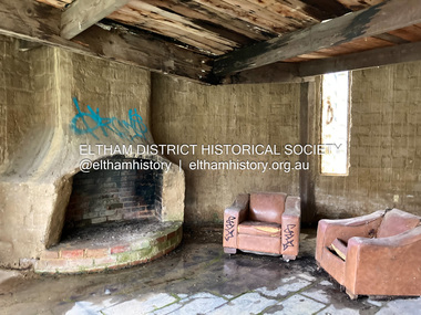 Eltham District Historical Society Inc
Photograph - Digital Photograph, Jim Connor, Fireplace, Boomerang House, 195 Laughing Waters Road, Eltham, 31 August 2021
Gordon Ford and photographer Sue Winslow were married in 1965. They set up home in an old log cabin on the property Gordon had purchased in 1954 on Laughing Waters Road. Situated between the Yarra River and Overbank Road, Gordon had built a small mud-brick shack on the river and a pontoon. Over the decades the shack has been locally referred to as “the love shack”, the “rooting shack” or simply “Gordon’s shack”. Gordon and Sue commissioned local builder Graeme Rose to do a wattle and daub renovation and extension to the old log cabin on the north side of Laughing Waters Road. The work had only just been completed in 1965 when a bushfire swept through the area and destroyed the cabin. Gordon and Sue relocated to his property, Fulling, in Pitt Street, Eltham. In 1970 work started on a new house at the Laughing Waters property. Originally known as the Banana House, it is now known as Boomerang. Designed by Alistair Knox, the mud-brick house includes iron window grilles made by Matcham Skipper that puncture the curved mud walls. The grilles were made from ‘off-pressings’ from the Sidchrome tool works in Heidelberg. Gordon, Sue and family moved into the house in 1972. Their marriage fell apart and Sue moved to Sydney with the children around the same time Gordon commenced building Birrarung just below Boomerang on the Laughing Waters Road block. After the Fords moved out, Boomerang it was rented out to various share households of students, musicians, artists and environmentalists for twenty-four years. Gordon Ford sold Birrarung and Boomerang to Melbourne Water in 1999. The Laughing Waters Artist in Residence Program was developed as a partnership between Parks Victoria and Nillumbik Shire Council. Boomerang was deemed unfit for habitation so was used as a day studio only. By 2001 Boomerang was in a poor state of repair and by 2002 the last artist in residence was to use the house as a studio. Nillumbik Shire Council had been granted funds from the Melbourne Community Fund to restore both Boomerang and Birrarung but it was apparent in early 2003 that the funds would be insufficient to restore both houses. Boomerang was infested with termites which presented a risk to any occupants and so the decision was made to close Boomerang and concentrate funding on Birrarung. Boomerang was fenced off for safety and to prevent intrusion and remains ‘caged’ today (2023). However, it is readily apparent the property has been occupied by squatters over the years. By 2023 it was clear that the squatters had abandoned the property and sections of the roof structure have given away in some areas and collapsed internally. For a more in-depth description and history of the property and that of Gordon and Sue Ford, see Jane Woollard's book, "Laughing Waters Road; Art, Landscape & Memory in Eltham" published 2016.jim connor collection, laughing waters road, boomerang house, gordon ford -
 Eltham District Historical Society Inc
Photograph - Digital Photograph, Jim Connor, The Love Shack, 195 Laughing Waters Road, Eltham, 7 September 2013
Laughing Waters Walk, 7 Sep 2013 This Society excursion was a follow up to the Laughing Waters Story told to us by Jane Woollard at our Annual General Meeting in March 2013. It involved a walk commencing from the corner of Laughing Waters and Overbank Roads along Laughing Waters Road to its eastern end and returning partly over the same route - a total distance of about 2.5km. On the way we visited the two artist in residence properties, River Bend and Birrarung, to view the houses on them that are associated with Alistair Knox, Gordon Ford and others in the local mud brick and artistic community. We also able to walk around the derelict ruin which was once home to Gordon and Sue Ford, Boomerang House. An unexpected afternoon tea was offered to us by the artists in residence at Birrarung House and we had a brief opportunity to view inside the house. Gordon Ford and photographer Sue Winslow were married in 1965. They set up home in an old log cabin on the property Gordon had purchased in 1954 on Laughing Waters Road. Situated between the Yarra River and Overbank Road, Gordon had built a small mud-brick shack on the river and a pontoon. Over the decades the shack has been locally referred to as “the love shack”, the “rooting shack” or simply “Gordon’s shack”. Gordon and Sue commissioned local builder Graeme Rose to do a wattle and daub renovation and extension to the old log cabin on the north side of Laughing Waters Road. The work had only just been completed in 1965 when a bushfire swept through the area and destroyed the cabin. Gordon and Sue relocated to his property, Fulling, in Pitt Street, Eltham. In 1970 work started on a new house at the Laughing Waters property. Originally known as the Banana House, it is now known as Boomerang. Designed by Alistair Knox, the mud-brick house includes iron window grilles made by Matcham Skipper that puncture the curved mud walls. The grilles were made from ‘off-pressings’ from the Sidchrome tool works in Heidelberg. Gordon, Sue and family moved into the house in 1972. Their marriage fell apart and Sue moved to Sydney with the children around the same time Gordon commenced building Birrarung just below Boomerang on the Laughing Waters Road block. After the Fords moved out, Boomerang it was rented out to various share households of students, musicians, artists and environmentalists for twenty-four years. Gordon Ford sold Birrarung and Boomerang to Melbourne Water in 1999. The Laughing Waters Artist in Residence Program was developed as a partnership between Parks Victoria and Nillumbik Shire Council. Boomerang was deemed unfit for habitation so was used as a day studio only. By 2001 Boomerang was in a poor state of repair and by 2002 the last artist in residence was to use the house as a studio. Nillumbik Shire Council had been granted funds from the Melbourne Community Fund to restore both Boomerang and Birrarung but it was apparent in early 2003 that the funds would be insufficient to restore both houses. Boomerang was infested with termites which presented a risk to any occupants and so the decision was made to close Boomerang and concentrate funding on Birrarung. Boomerang was fenced off for safety and to prevent intrusion and remains ‘caged’ today (2023). However, it is readily apparent the property has been occupied by squatters over the years. By 2023 it was clear that the squatters had abandoned the property and sections of the roof structure have given away in some areas and collapsed internally. For a more in-depth description and history of the property and that of Gordon and Sue Ford, see Jane Woollard's book, "Laughing Waters Road; Art, Landscape & Memory in Eltham" published 2016.2013-09-07, activities, eltham district historical society, heritage excursion, jim connor collection, laughing waters road, boomerang house, gordon ford, gordon's shack, love shack -
 Eltham District Historical Society Inc
Photograph, Fay Bridge, The Love Shack, 195 Laughing Waters Road, Eltham, April 2016
Gordon Ford built this shack on the Yarra at Laughing Waters Road. Bernie Bragg used to live there for a period of time. Gordon Ford and photographer Sue Winslow were married in 1965. They set up home in an old log cabin on the property Gordon had purchased in 1954 on Laughing Waters Road. Situated between the Yarra River and Overbank Road, Gordon had built a small mud-brick shack on the river and a pontoon. Over the decades the shack has been locally referred to as “the love shack”, the “rooting shack” or simply “Gordon’s shack”. Gordon and Sue commissioned local builder Graeme Rose to do a wattle and daub renovation and extension to the old log cabin on the north side of Laughing Waters Road. The work had only just been completed in 1965 when a bushfire swept through the area and destroyed the cabin. Gordon and Sue relocated to his property, Fulling, in Pitt Street, Eltham. In 1970 work started on a new house at the Laughing Waters property. Originally known as the Banana House, it is now known as Boomerang. Designed by Alistair Knox, the mud-brick house includes iron window grilles made by Matcham Skipper that puncture the curved mud walls. The grilles were made from ‘off-pressings’ from the Sidchrome tool works in Heidelberg. Gordon, Sue and family moved into the house in 1972. Their marriage fell apart and Sue moved to Sydney with the children around the same time Gordon commenced building Birrarung just below Boomerang on the Laughing Waters Road block. After the Fords moved out, Boomerang it was rented out to various share households of students, musicians, artists and environmentalists for twenty-four years. Gordon Ford sold Birrarung and Boomerang to Melbourne Water in 1999. The Laughing Waters Artist in Residence Program was developed as a partnership between Parks Victoria and Nillumbik Shire Council. Boomerang was deemed unfit for habitation so was used as a day studio only. By 2001 Boomerang was in a poor state of repair and by 2002 the last artist in residence was to use the house as a studio. Nillumbik Shire Council had been granted funds from the Melbourne Community Fund to restore both Boomerang and Birrarung but it was apparent in early 2003 that the funds would be insufficient to restore both houses. Boomerang was infested with termites which presented a risk to any occupants and so the decision was made to close Boomerang and concentrate funding on Birrarung. Boomerang was fenced off for safety and to prevent intrusion and remains ‘caged’ today (2023). However, it is readily apparent the property has been occupied by squatters over the years. By 2023 it was clear that the squatters had abandoned the property and sections of the roof structure have given away in some areas and collapsed internally. For a more in-depth description and history of the property and that of Gordon and Sue Ford, see Jane Woollard's book, "Laughing Waters Road; Art, Landscape & Memory in Eltham" published 2016.fay bridge collection, 2016-04, bernie's hut, birrarung, gordon ford, gordon's shack, laughing waters road, love shack, yarra river -
 Eltham District Historical Society Inc
Photograph, Fay Bridge, The Love Shack, 195 Laughing Waters Road, Eltham, 22 July 2016
Gordon Ford built this shack on the Yarra at Laughing Waters Road. Bernie Bragg used to live there for a period of time. Gordon Ford and photographer Sue Winslow were married in 1965. They set up home in an old log cabin on the property Gordon had purchased in 1954 on Laughing Waters Road. Situated between the Yarra River and Overbank Road, Gordon had built a small mud-brick shack on the river and a pontoon. Over the decades the shack has been locally referred to as “the love shack”, the “rooting shack” or simply “Gordon’s shack”. Gordon and Sue commissioned local builder Graeme Rose to do a wattle and daub renovation and extension to the old log cabin on the north side of Laughing Waters Road. The work had only just been completed in 1965 when a bushfire swept through the area and destroyed the cabin. Gordon and Sue relocated to his property, Fulling, in Pitt Street, Eltham. In 1970 work started on a new house at the Laughing Waters property. Originally known as the Banana House, it is now known as Boomerang. Designed by Alistair Knox, the mud-brick house includes iron window grilles made by Matcham Skipper that puncture the curved mud walls. The grilles were made from ‘off-pressings’ from the Sidchrome tool works in Heidelberg. Gordon, Sue and family moved into the house in 1972. Their marriage fell apart and Sue moved to Sydney with the children around the same time Gordon commenced building Birrarung just below Boomerang on the Laughing Waters Road block. After the Fords moved out, Boomerang it was rented out to various share households of students, musicians, artists and environmentalists for twenty-four years. Gordon Ford sold Birrarung and Boomerang to Melbourne Water in 1999. The Laughing Waters Artist in Residence Program was developed as a partnership between Parks Victoria and Nillumbik Shire Council. Boomerang was deemed unfit for habitation so was used as a day studio only. By 2001 Boomerang was in a poor state of repair and by 2002 the last artist in residence was to use the house as a studio. Nillumbik Shire Council had been granted funds from the Melbourne Community Fund to restore both Boomerang and Birrarung but it was apparent in early 2003 that the funds would be insufficient to restore both houses. Boomerang was infested with termites which presented a risk to any occupants and so the decision was made to close Boomerang and concentrate funding on Birrarung. Boomerang was fenced off for safety and to prevent intrusion and remains ‘caged’ today (2023). However, it is readily apparent the property has been occupied by squatters over the years. By 2023 it was clear that the squatters had abandoned the property and sections of the roof structure have given away in some areas and collapsed internally. For a more in-depth description and history of the property and that of Gordon and Sue Ford, see Jane Woollard's book, "Laughing Waters Road; Art, Landscape & Memory in Eltham" published 2016.fay bridge collection, 2016-07-22, bernie's hut, birrarung, gordon ford, gordon's shack, laughing waters, laughing waters road, love shack, yarra river -
 Eltham District Historical Society Inc
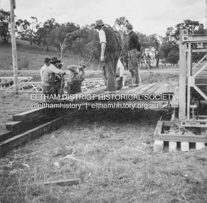
Album - Photograph, J.A. McDonald, Dixons Creek Road, Oct. 1955
October 1955 Ramping north sideRecord of various Shire of Eltham infrastructure works undertaken during the period of 1952-1962 involving bridge and road reconstruction projects, sometimes with Eltham Shire Council Project Reference numbers quoted. It was during this period that a number of significant improvements were made to roads and new bridges constructed within the shire that remain in place as of present day (2022). In many situations, the photos provide a tangible visible record of infrastructure that existed throughout the early days of the Shire. The album was put together by or under the direction of the Shire Engineer, J.A. McDonald.infrastructure, road construction, shire of eltham, 1955-10, bailey bridge, bridge construction, dixons creek bridge, dixon's creek road