Showing 576 items matching "route map"
-
 Ballarat Tramway Museum
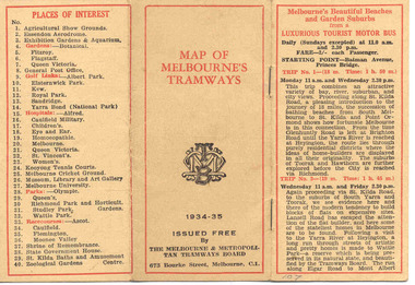
Map, Melbourne and Metropolitan Tramways Board (MMTB), "MMTB Map of Melbourne Tramways 1934-5", 1934
Demonstrates methods of giving information to visitors to Melbourne and yields information about tram services at the time in Melbourne.Very small pocket sized timetable and map book, consisting of 2 octavo cards stapled and folded into 12 pages consisting of three pages of bus and tram round trips, 3 center pages for map of electric and cable trams, route numbers and interest points. Map printed in 4 colours. 4 pages index to routes and first and last trams to City and from City. Also gives points where suburban routes are intersected by City routes. One page devoted to places of interest. All printing in black with red headings and highlights.trams, tramways, mmtb map, mmtb, timetables, tourist trips, map -
 Ballarat Tramway Museum
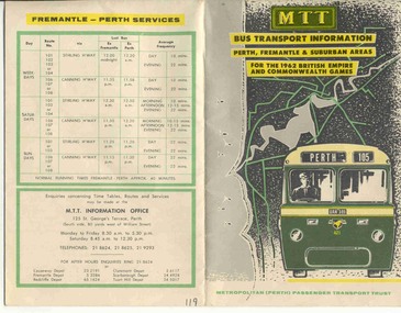
Ephemera - Timetable and map, MTT Perth, "MTT Bus Transport Information 1962" - Perth, 1962
... Colour map of Perth bus routes and trolley bus routes... Timetables Colour map of Perth bus routes and trolley bus routes ...Colour map of Perth bus routes and trolley bus routes on soft card or heavy paper. At time of the 1962 British Empire and Commonwealth Games. Title "MTT Bus Transport Information 1962" - Perth.mtt, perth, bus routes, timetables -
 Ballarat Tramway Museum
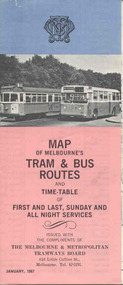
Map, Survey and Mapping for MMTB, "Map of Melbourne's Trams and Bus routes and all night services", Jan. 1967
... - "Map of Melbourne's Trams and Bus routes and all night services... and Bus routes and all night services" map shows trams lines ...Fold out sheet coloured map, 12 portions or folds, - title - "Map of Melbourne's Trams and Bus routes and all night services" map shows trams lines, route numbers, terminal points, bus routes, railway lines, blow up of city area with places of interest and key. On rear details, places of interest, suburb index, index to routes, first and last services, Sunday am services, all night bus services and locations of depots and head office. 2nd copy added 11-8-2006. Images of document - scanned to A3 size and overlapping added 30/10/13 On rear "out of date" stamp and 1 "cancelled" stamp - red ink.trams, tramways, melbourne, map, tram & bus services, all night services -
 Ballarat Tramway Museum
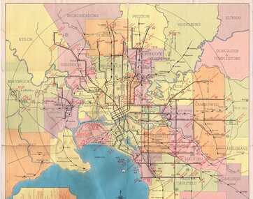
Map, Compiled by MMTB, "Map and timetable of Melbourne Tram and Bus Services" - May 1956, May. 1956
Fold out map (10 sections), coloured of Melbourne's Tram and Bus routes, route numbers, rail lines, municipalities boundaries and location of major places of interest. At base of map - timetable of all night trams and bus services. On rear index to routes, 1st and last services, time of Sunday am services, Latrobe St. services and photo of Wattle Park.trams, tramways, melbourne, map, tram & bus services, all night services, mmtb -
 Ballarat Tramway Museum
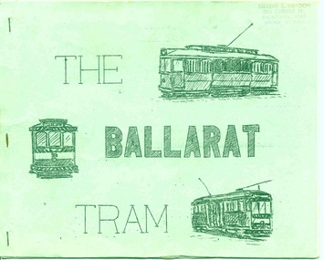
Book, A. Weston & Geoff Clark of North Sydney Boys High School, "The Ballarat Tram", Jul. 1971
Produced by the North Sydney Boys High School Railway club, prior to the closure of the Ballarat system - little else written and published at the time about the history and details of the system. A very good booklet for the time - produced entirely by the wax cut stencil process. Has a strong association with the people who prepared the document.Twenty page booklet on the history, operation and tramcars of Ballarat, produced by the Nth Sydney Boys High School Railway Club in July 1971. Printed on a wax cut stencil process, with green covers, drawings, maps, track layout, fleet list, gives tentative closure dates, route descriptions, sketches, stapled on edge. Title "The Ballarat Tram". Stapled on the left hand side. Three copies held - 3rd copy added 22/10/05. 4th copy added 11/10/2007 and image of cover added as well. pdf image of copy added 2/11/13 - to produce the scan, copy 2 was unstapled and filed loose - may not open properly in dbtext. find file and open directly. See Reg Item 6388 for the Bendigo version.3rd copy - page 3 - in black ink "Ballarat Tramway Preservation Society Catalogue No. 118", On top right hand corner "Graeme Breydon address stamp"trams, tramways, ballarat trams, secv, tramcars -
 Apollo Bay Museum
Audio - Richard Collopy on middens on the Coastal Walk route
Recorded by Gadubanud Traditional Custodian Richard Collopy as part of the Heart Maps projectapollo bay, great ocean road, gadubanud, middens -
 Kew Historical Society Inc
Plan - Subdivision Plan, H C Crouch, Old Golf Links Estate, 1930s
The land in North Kew between the Outer Circle Railway and the River Yarra was released in sections. This release included 80 lots. Most of this area was released during the Depression years in the early 1930s.Subdivision plans are historically important documents used as evidence of the growth of suburbs in Australia. They frequently provide information about when the land was sold on which a built structure was subsequently constructed as well as evidence relating to surveyors and real estate and financial agents. The numerous subdivision plans in the Kew Historical Society's collection represent working documents, ranging from the initial sketches made in planning a subdivision to printed plans on which auctioneers or agents listed the prices for which individual lots were sold. In a number of cases, the reverse of a subdivision plan in the collection includes a photograph of a house that was also for sale by the agent. These photographs provide significant heritage information relating house design and decoration, fencing and household gardens.One part of a massive subdivision of the Old Golf Links Estate in North Kew of 80 allotments bordering Sutherland Avenue, Ramsay Avenue, Belford Road, Beresford Street and Coleman Avenue. Inset on the plan at the top left, the route of the Outer Circle Railway is clearly marked. The Kew Golf Links is identified in its current location. The land on which Greenacres Golf Club was to be constructed is at this time marked as ‘Recreation Ground’. The ‘new bridge’ over the Yarra at Burke Road is also marked on the inset map. The Plan identifies the surveyor (sic) H.C. Crouch BCE MVIS, 443 Little Collins St., Melbourne. The date of the subdivision auction sale in identified as Saturday September 25th at three o'clock.Annotations: "E" top left. "Golf Links" top right. Lots 73-76 ticked and listed as "6" poundssubdivisions -- kew (vic.), old golf links estate -
 Kew Historical Society Inc
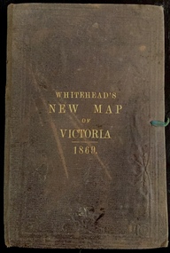
Map, Whitehead's Map of Victoria, With Alphabetical Key, 1869, 1869
When E. Whitehead's New Map of Victoria was released in 1869, an advertisement in the Bendigo Advertiser (16 July 1869) noted that: "This beautifully engraved Map has been revised and brought down to the present time; and, with the Alphabetical Key, is the most complete and the cheapest Map ever published; Price, 6d plain; 1s colored; 2s 6d in case; on linen, post free, 2d extra. E.. WHITEHEAD and CO, Publishers, 67 Collins-street east." The following year, 1870, Whitehead's promoted the edition in the Portland Guardian and Normanby General Advertiser (3 January 1870), advising that: "WHITEHEAD'S NEW MAP OF VICTORIA, 1869 ... is corrected to the latest date, and around is arranged an Alphabetical Key, with Post Towns and Money Order Olffices marked. The Map being divided into squares and numbered, by reference to the Key any place can be found immediately. Price Is beautifully colored, or mounted on linen in case, 2s 6d. Post free, 2d extra, in Victoria. B. Whitehead and C0., Puolishers, 67 Collins-street East, Melbourne". In the same edition of the Portland Advertiser, they also promoted their business generally, saying: "E WHITEHEAD and Co., Stationers, Engravers, Lithographers, 67 Collins street East, execute every description of Lithographic PRINTING, BILL-HEADS. NOTE Headings. Business Dies Engraved and Embossed on Envelopes &c. ARMS, MONOGRAMS, AND CRESTS Engraved and Embossed in Colour, superior to any other house in the Colony. Specimens, post free, 2d. Lithographers, &c, to H.R.H. the Duke of Edinburgh, and Die-inkers and Embossers to His Excellency Sir J. H. T. Manners-Sutton, K C.B. Orders executed for the Trade". Whitehead’s New Map of Victoria 1869 is is an important record of region created towards the end of the Victorian Gold Rush (1851-1869). In addition to its historical significance, this is a rare map, of which the only known copies in Australian public collections are those held at the National Library of Australia, the State Library of Victoria, State Library of New South Wales and the University of Queensland Library.Map of Victoria with gold mining areas, notes on topography, transport routes. Relief shown by hachures. List of towns with distance from Melbourne in map margin. [Melbourne] : Printed & Published by ... E Whitehead & Co ... 67 Collins Street East, 1869 1 map : col., mounted on linen ; 38.4 x 55.4 cm, folded to 18 x 12 cm.Cover "WHITEHEAD'S NEW MAP OF VICTORIA 1869"maps - victoria - 1860s, e whitehead's new map of victoria 1869, whitehead's map of victoria with alphabetical key 1869, cartography, gold rush -
 Kew Historical Society Inc
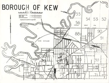
Plan, Borough of Kew, 1910
This work forms part of the collection assembled by the historian Dorothy Rogers, that was donated to the Kew Historical Society by her son John Rogers in 2015. The manuscripts, photographs, maps, and documents were sourced by her from both family and local collections or produced as references for her print publications. Many were directly used by Rogers in writing ‘Lovely Old Homes of Kew’ (1961) and 'A History of Kew' (1973), or the numerous articles on local history that she produced for suburban newspapers. Most of the photographs in the collection include detailed annotations in her hand. The overhead transparency is of a map produced by H.C. Crouch Borough Surveyor in 1910The Rogers Collection provides a comprehensive insight into the working habits of a historian in the 1960s and 1970s. Together it forms the largest privately-donated collection within the archives of the Kew Historical Society.An overhead transparency of a plan of Kew comparing the roads in 1860 with later roads constructed by 1910. Sections of the plan are marked with the location of particular buildings, farms or transport routes.Borough of Kewborough of kew, h.c. crouch -
 Kew Historical Society Inc
Booklet, Dorothy Rogers, A Tour of Melbourne en Route to Invergowrie conducted by the Royal Historical Society of Victoria, Saturday 29 July 1967, 1967
[Melbourne : The Society, 1967] 26 p. ; 21 x 17 cm. non-fictionhistoric buildings -- victoria -- melbourne., melbourne (vic.) -- description and travel., melbourne (vic.) -- buildings, structures, etc. -
 Kew Historical Society Inc
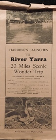
Flyer, Melbourne Ferries Pty Ltd, River Yarra: 20 Miles Scenic Wonder Trip
... collection Bifold brochure including route map of the full 44 mile ...Bifold brochure including route map of the full 44 mile 'Wonder Trip' on pages 2 & 3. Photos used include an 'Aerial view over Dight's Falls', two ferries, and a 'Scene near Dight's Falls'.Flyer for Harding’s Launches on the River Yarra: 20 miles scenic wonder trip. Aerial view over Dight’s Falls on front. non-fictionBifold brochure including route map of the full 44 mile 'Wonder Trip' on pages 2 & 3. Photos used include an 'Aerial view over Dight's Falls', two ferries, and a 'Scene near Dight's Falls'.river yarra, melbourne ferries pty ltd, yarra river -- tourism, harding's cruises, christian-washfold collection -
 Clayton RSL Sub Branch
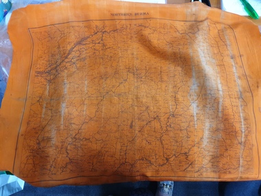
Memorabilia - Silk Escape Scarf, WW2
Escape scarf was issued to all military personnel, both army and airforce and personnel in theatres of war. The scarf was designed to provide information on escape routes if the soldier/pilot was captured. The scarf was donated to the RSL by Cedric Hamilton Chindit WW2.Unusual orange silk escape scarf with Burma and North Burma map. Colour may indicate that the scarf was primarily to be used for nighttime viewing.orange silk scarf with map of burma on one side and a map of north burma on the other side.One side - Central Burma Second side - North Burmaworld war two, second world war, ww2, wwii, scarf, burma, escape scarf -
 Glen Eira City Council History and Heritage Collection
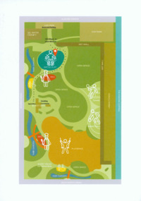
Event Run-sheet and Map, "Booran Reserve Official Opening"
This run-sheet and map were used for the opening of Booran Reserve at the corner of Booran and Glenhuntly Roads on Tuesday 11 April 2017. The Reserve was officially opened by the Mayor, Cr. Mary Delahunty and The Hon. Philip Dalidakis, MP, Minister for Innovation. The run-sheet contains information about the Order of Proceedings of the opening ceremony. The map notes the locations of reserved parking, the route taken by Mayor Mary Delahunty and Minister Philip Dalidakis through the Reserve, and the speech and smoking ceremony site. The site of the Reserve was previously the Caulfield Service Reservoir.Black and white printed run-sheet, and green, teal, red, yellow, blue and khaki colour printed map -
 City of Greater Bendigo - Civic Collection
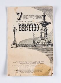
Booklet, J. W. H Publications, 7 Routes. Sightseeing in and around Bendigo, c 1950
A publication promoting visitation and automobile touring around Bendigo and surrounding districts. Suggests seven routes and contains extensive advertising for accommodation, businesses and services within Bendigo and Castlemaine.Thirty two page tourist fold out booklet containing maps and directions for half day and day routes in the district. Booklet also contains advertising promoting Bendigo and District businesses. city of greater bendigo commerce, city of greater bendigo tourism, making a nation exhibition -
 Melbourne Tram Museum
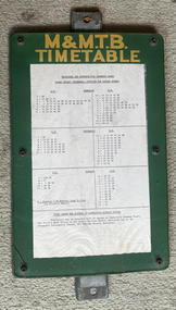
Functional object - Timetable Board, Melbourne & Metropolitan Tramways Board (MMTB), Camberwell Junction - Batman Ave, 1970s
Timetable board for Camberwell Junction Batman Ave route 70, detailing times that services were scheduled to depart the Junction. Probably used until replaced by The Met style signs in the mid-1980s.Demonstrates a timetable board style used by the MMTB in the 1970s and early 1980s.Board made up to display tramway timetables for attachment to a post comprising heavy galvanised steel backing sheet with two small channels either end, spot welded to the steel back, front painted in green with the letters "M&M.T.B" in yellow paint, perspex sheet at the front, secured by 6 Allen screws with nuts on rear, containing a typed timetable sheet - for Camberwell Junction for Batman Ave timetable - undated. tramways, map, batman ave, camberwell junction, route 70, timetable -
 Melbourne Tram Museum
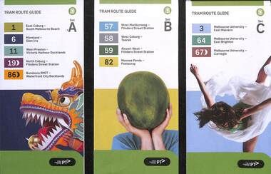
Ephemera, Public Transport Victoria (PTV), "Tram Route Guide", 2/2024
... is a large map, and a short summary of the routes list in the guide ...Route Guides published Feb. 2024, by Public Transport Victoria listing the stops, interchanges with bus and other tram services, ticketing zones, estimated frequencies with adverts for Night tram services, TramTracker and Myki tickets. On the rear is a large map, and a short summary of the routes list in the guide. .1 - Set A - Routes 1, 6, 11, 19 and 86 .2 - Set B - Routes 57, 58, 59 and 82 .3 - Set C - Routes 3, 64 and 67 .4 - Set D - Routes 48, 70, 75, 78 and 109 .5 - Set E - Routes 5, 6, 16, 58 and 72 .6 - Set F - Routes 12, 30, 35, 96 See item 2279 for an earlier versions.Demonstrates a PTV published tram route guide of 2024.Set of 6 pamphlets folded A2 to DL sheets, full colour.trams, tramways, timetables, route guides, maps, route 1, route 3, route 5, route 6, route 11, route 19, route 86, route 57, route 58, route 59, route 82, route 64, route 67, route 48, route 70, route 75, route 78, route 109, route 16, route 72, route 12, route 30, route 35, route 96 -
 Stawell Historical Society Inc
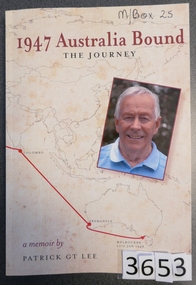
Book, Patrick G.T. Lee, 1947 Australia Bound - The Journey - Previously Cat No 3653, 2016
... Card Cover. Line drawn map showing the sea route from... Inside: To Jim Best Wishes Pat Card Cover. Line drawn map ...Chapter 7 relates to the family Life in Stawell Card Cover. Line drawn map showing the sea route from England to Melbourne, and a colour photo of the Author 1947 Australia Bound Thoe Journey A memoir by Patrick GT Lee Inside: To Jim Best Wishes Patstawell -
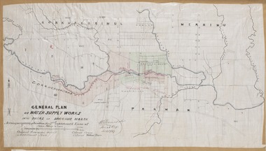 Bacchus Marsh & District Historical Society
Map, General Plan for Water Supply Works, Shire of Bacchus Marsh 1887
Debate about water supply and its planning and development took place in the Bacchus Marsh region from the 1850s through into the twentieth century. This plan was part of documentation to support an application for an additional loan of money from the Ministry of Water Supply to the Bacchus Marsh Shire Water Supply Trust. The plan includes the route of a proposed water channel in the Parwan area, and other features of water supply infrastructure such as the location of standpipes and gates are also shown on the plan.A single page paper map showing a general plan for the supply of water in the Bacchus Marsh area.The plan shows the route of the 'Main Channel' near the Werribee River and a proposed route for a Parwan Channel. The location of 'Dryden's House' near the Werribee River is also shown and the locations of land held by T. (Tom) Oliver and the Racecourse Reserve in Maddingley. Scale 40 chains to 1 inch. The plan is signed by Bacchus Marsh Shire Engineer, W.E. Standfield. The map is pasted into a bound volume containing 76 maps or plans in total. High resolution digital image stored on BMDHS computer network. General Plan of Water Supply Works in the Shire of Bacchus Marsh. Accompanying application for 2nd additional Loan. Original Waterworks district. Additional area. W.E. Standfield, 30/8/87.water supply, water supply maps, water supply bacchus marsh, irrigation, bacchus marsh victoria maps -
 Melbourne Tram Museum
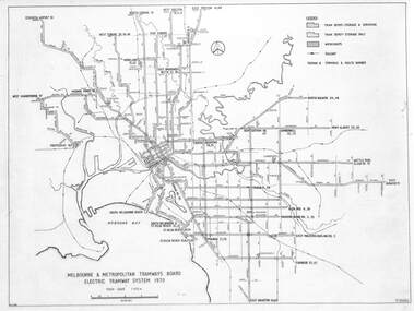
Drawing, Melbourne & Metropolitan Tramways Board (MMTB), "Melbourne & Metropolitan Tramways Board Electric Tramway System 1979", 1979
... system in 1979 trams tramways map mmtb trackwork depots route ...Drawing of the track plan for the Melbourne Tramway System in 1979 over two separate sheets - titled "Melbourne & Metropolitan Tramways Board Electric Tramway System 1979". Shows the route numbers and terminus names, depot locations, rail lines, cross overs and junctions. Has the name J.Chau in bottom left hand corner. Yields information about the the Melbourne tram system in 1979Drawing - print on paper P15060. Two copies held.trams, tramways, map, mmtb, trackwork, depots, route numbers, railways, junction -
 Victorian Railway History Library
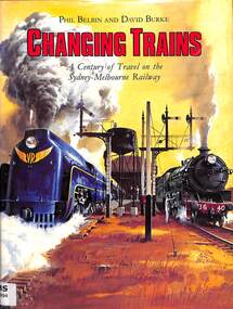
Book, Burke, David et al, Changing Trains, 1982
A century of travel on the Sydney-Melbourne railway from 1882 to 1982index, ill, maps. p.144.non-fictionA century of travel on the Sydney-Melbourne railway from 1882 to 1982railway services. routes. australia. sydney-melbourne line, railroads -- australia -- history -
 Victorian Railway History Library
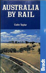
Book, Taylor, Colin, Australia By Rail, 1988
From the vast emptiness of the Nullarbor Plain, on the longest straight rail line in the world, to the twisting tracks of outback Queensland and the rainforests of the north, Australia's railways offer a rich variety of contrasting experiences. Taking the train is an ideal way to explore the continent in comfort and style. Features include: fully revised fifth edition- updated and expanded: with seventy maps including the new Ghan extension to Darwin, rail travel for all budgets--from the five-star luxury of the Great South Pacific Express to economy sleeping berths for budget-conscious travellers, plus full details of the Austrailpass and other passes and ticket bargains, railway route guides with seventy rail maps--all main lines and branches, what to look out for when travelling, and where to stop, railway history--and the battle for the survival of rail in Australia, city guides and maps--the best sights, recommended hotels, and restaurants in many stops along the lines; with extensive sections on Sydney, Melbourne, Brisbane, Adelaide, Perth, Darwin, and Canberra.ill, maps, p.144.non-fictionFrom the vast emptiness of the Nullarbor Plain, on the longest straight rail line in the world, to the twisting tracks of outback Queensland and the rainforests of the north, Australia's railways offer a rich variety of contrasting experiences. Taking the train is an ideal way to explore the continent in comfort and style. Features include: fully revised fifth edition- updated and expanded: with seventy maps including the new Ghan extension to Darwin, rail travel for all budgets--from the five-star luxury of the Great South Pacific Express to economy sleeping berths for budget-conscious travellers, plus full details of the Austrailpass and other passes and ticket bargains, railway route guides with seventy rail maps--all main lines and branches, what to look out for when travelling, and where to stop, railway history--and the battle for the survival of rail in Australia, city guides and maps--the best sights, recommended hotels, and restaurants in many stops along the lines; with extensive sections on Sydney, Melbourne, Brisbane, Adelaide, Perth, Darwin, and Canberra.railroad travel -- australia -- guidebooks, railroad travel -- australia -
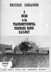 Victorian Railway History Library
Book, New South Wales Rail Transport Museum, Western Endeavour: A Guide to the Transcontinental Standard Gauge Railway, 1970
A Guide to the Transcontinental Standard Gauge Railway for the special Western Endeavour train from Sydney to Perth to commemorate the opening of the standard gauge all the way through from 22-08 to 12-09-1970. Complete with maps and details of the route from Sydney to Perth.ill, maps, p.90.non-fictionA Guide to the Transcontinental Standard Gauge Railway for the special Western Endeavour train from Sydney to Perth to commemorate the opening of the standard gauge all the way through from 22-08 to 12-09-1970. Complete with maps and details of the route from Sydney to Perth.railroad passenger trains - australia, western endeavour special passenger train - australia -
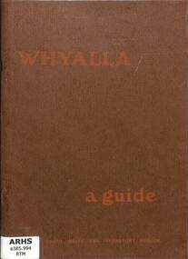 Victorian Railway History Library
Book, New South Wales Rail Transport Museum, Whyalla a guide, 1972
... train run in 1972 complete with maps of the route. ill, maps, p ...A guide to the standard gauge railway from Sydney to Whyalla & Maree for a special passenger train run in 1972 complete with maps of the route.ill, maps, p.67.non-fictionA guide to the standard gauge railway from Sydney to Whyalla & Maree for a special passenger train run in 1972 complete with maps of the route.special passenger train - australia, transcontinental railway - australia - history -
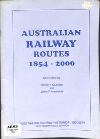 Victorian Railway History Library
Book, Australian Railway Historical Society NSW Division et al, Australian Railway Routes 1854-2000, 2000
Descriptions of railway routes in Australia from 1854 to 2000.maps, p.80.non-fictionDescriptions of railway routes in Australia from 1854 to 2000.railroad construction - australia - history, railroads -- australia -- history. -
 Victorian Railway History Library
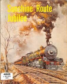
Book, Australian Railway Historical Society - Queensland Division et al, Sunshine Route Jubilee, 1975
... 50th anniversary. ill, maps, p.80. Sunshine Route Jubilee Book ...A pictorial history of the North Coast mainline of the Queensland Government railways from Brisbane to Cairns to mark its 50th anniversary.ill, maps, p.80.non-fictionA pictorial history of the North Coast mainline of the Queensland Government railways from Brisbane to Cairns to mark its 50th anniversary.queensland railways -- history., railroad construction - queensland - history -
 Victorian Railway History Library
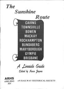
Booklet, Joynes, Kevin, The Sunshine Route: A Lineside Guide
A lineside guide to the 'Sunshine Route' Queensland Government railway from Brisbane to Cairns.ill, maps, p.50.non-fictionA lineside guide to the 'Sunshine Route' Queensland Government railway from Brisbane to Cairns.railroad operations - queensland - history, railroad construction - queensland - history -
 Moorabbin Air Museum
Book - Inflight 1960's vintage passenger information booklet touching on Qantas history and small travel goods available in flight, as well maps of the Kangaroo Route, QANTAS KANGAROO ROUTE FLIGHT GUIDE, Qantas, QANTAS KANGAROO ROUTE FLIGHT GUIDE, Mid 1960's
... in flight, as well maps of the Kangaroo Route, QANTAS KANGAROO ROUTE... in flight, as well maps of the Kangaroo Route, QANTAS KANGAROO ROUTE ...Inflight 1960's vintage passenger information booklet touching on Qantas history and small travel goods available in flight, as well maps of the Kangaroo Route, QANTAS KANGAROO ROUTE FLIGHT GUIDEFront cover abstract colourful representation presumably ?? of a kangaroo, all on a white backgroundnon-fictionInflight 1960's vintage passenger information booklet touching on Qantas history and small travel goods available in flight, as well maps of the Kangaroo Route, QANTAS KANGAROO ROUTE FLIGHT GUIDE -
 Victorian Railway History Library
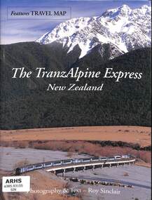
Book, Sinclair, Roy, The TranzAlpine Express New Zealand, 2004
A pictorial record of the route of the TranzAlpine Express from Christchurch to Greymouth in the South Island of New Zealand.ill, maps, p.32.non-fictionA pictorial record of the route of the TranzAlpine Express from Christchurch to Greymouth in the South Island of New Zealand.railroads - new zealand - pictorial, railroads - new zealand - tranz-alpine -
 Victorian Railway History Library
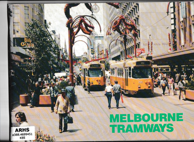
Book, Transit Press, Melbourne Tramways, 1985
The vehicles, routes and workshops of the Melbourne tramway systemIll, maps, p.84.non-fictionThe vehicles, routes and workshops of the Melbourne tramway systemtramways - melbourne - history, tramways - melbourne -
 Victorian Railway History Library
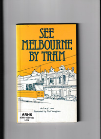
Book, Marian De Lacy Lowe, See Melbourne by tram, 1982
... of the various tram routes in Melbourne and the sights along those routes ...Descriptions of the various tram routes in Melbourne and the sights along those routesIndex, ill, maps, p.149.non-fictionDescriptions of the various tram routes in Melbourne and the sights along those routestramways - melbourne, melbourne - guide books