Showing 357 items matching "rural development"
-
 Surrey Hills Historical Society Collection
Book, An historical geography of Surrey Hills, 1882-1913, 1979
A thesis submitted for the Degree of Bachelor of Arts with Honours. This thesis presents in a description form, the development of Surrey Hills, an eastern suburb of Melbourne. The settlement and growth from a rural district in 1882 to a suburban centre in 1913.This thesis presents in a description form, the development of Surrey Hills. The settlement and growth from a rural district in 1882 to a suburban centre in 1913.surrey hills, geography, topography, j. knipe, land use, population -
 Melton City Libraries
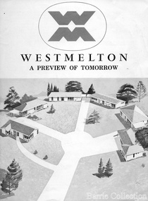
Document, West Melton: A preview of tomorrow, c.1969
"In April 1969, the first major residential development in Melton began with the release of 148 homes for purchase. This was the first stage of a staggered release of a planned 30,000 homes for 100,000 people by 1990. The development, called Westmelton Satellite City, was described as ‘a preview of tomorrow’.101 It was the first estate built in a ‘modern’ style, with curved streets, and dozens of culs de sac. Westmelton was also the first major development in Victoria to build all the supply lines to the houses – including electricity and telephone lines – underground. The six different home designs in Westmelton were ‘specially designed for the future’, and with allotments ten feet wider than regulations required, there was plenty of ‘space for gracious living’ and for a family swimming pool. The developers of this new estate were active in promoting Westmelton as a new community within the Shire of Melton. By 1971, the Westmelton City News reported that Ian McIntosh, General Manager of Westmelton, had given away $100,000 on behalf of the company ‘to aid community projects’. This included a $72,000 donation towards building a community centre in Westmelton, and $25,000 for the shire’s Olympic-sized swimming pool. Ian McIntosh and his family moved to Melton and Ian said he was ‘very much aware of the needs of [the] Westmelton community’. By the end of 1971, Westmelton was home to 100 new families. The modern residences were obviously an appealing drawcard, but so was the country feel that characterised Melton. Mrs C. Allen, described as a ‘housewife’, said she and her husband chose to move to Westmelton because of ‘the quality homes ... and we both love the clean, fresh, natural environment that surrounds us’. Similarly, Mr W. Coxhead, insurance consultant, moved to Westmelton because of the ‘clean, fresh country air’. Accountant Mr B. Swanton echoed their sentiments, describing Westmelton as ‘far enough away from the industrial pollution carried over Melbourne suburbs by prevailing westerly winds’. The new development attracted an increasing number of young, professional couples and families, representing the beginning of a significant shift from the predominantly rural and farming community of the district’s past. The Westmelton development had four different ‘neighbourhoods’ designed to cater to a variety of different lifestyle needs. Westmelton was the first to be established, followed by Brookfield, which offered ‘superb land in a rustic setting’. Brookfield Acres offered ‘wide open spaces with lots of room for a pool and even a tennis court’ on huge one-acre blocks, while Westlake was an innovative development with ‘different sized homesites’ and ‘lakeside living’.Westmelton was the first of many residential developments that would come to play a huge role in shaping the shire in the decades to follow".A marketing brochure for the Westmelton Satellite City developmentlocal significant events, council -
 Melton City Libraries
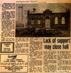
Newspaper, Lack of support may close hall, 1977
"The Mechanics Institute movement flourished in Victoria from 1839 to 1950. It was based on the development of Mechanics’ Institutes in Scotland and England from the 1820s, which were intended to educate and enlighten the working classes. The term ‘mechanic’ in those days meant an artisan, craftsman or working man, especially those who had moved from rural areas to work in new city factories during the Industrial Revolution. The early Institutes were usually equipped with a reading room, a library and a lecture room. Although enjoying mixed success in Britain, they contributed to the development of public education and library services. The movement was adopted more enthusiastically in the colonies. It began slowly in Victoria but its expansion after the gold rushes population influx was rapid, especially in rural areas. Every suburb and town wanted to have a Mechanics’ Institute. During the 1850s approximately forty Institutes were established, with even greater growth in the period 1860 to 1900. By 1900 there were 400 Institutes in Victoria. The establishment of a Mechanics’ Institute was often a great achievement for a local community, requiring organising committees to raise substantial funds for a building site (where this had not been granted by the Government), and the building. Once built, the committee then had to purchase books, provide a caretaker or librarian, and finance the ongoing use of and improvements to the building. ‘The history of many Institutes is a story of tremendous community effort, and often, financial difficulties’. In addition to being monuments to local enterprise and community life, the Mechanics’ Institutes played a vital role as an intellectual forum, and in contributing to an informed and participatory democracy in the late nineteenth and early twentieth centuries. They provided journals and other reading matter on local, state, national and international issues, and hosted of lectures and held debates about wider issues such as Federation, colonial nationalism, defence, female suffrage, the price of land and labour. With the development of the school and technical education in the latter part of the nineteenth century, the need for community technical and adult education declined. As a result of the introduction of government library grants in 1867, many Mechanics’ Institutes incorporated a free library in their buildings to finance collection of their books. By 1884-85, there were 257 free libraries in Victoria. However, government support and library grants dropped off in the 1890s depression. Entertainment took on a greater role in the 1890s, with the introduction of moving pictures, billiards rooms, games rooms (chess), concerts and dances. The First World War had a devastating impact on many rural communities, and some Mechanics’ Institutes were no longer viable. On the other hand the early twentieth century was also a time of agricultural development, and many country towns were growing in this period. The 1930s depression further limited growth of many libraries and reduced grants substantially. In response many Mechanics’ Institutes were renamed, for example as memorial halls, in order to retain and attract more patrons (eg at nearby Sunbury). The diminishing role for Mechanics’ Institutes and the preference for larger and better appointed halls (with supper rooms, cloak rooms etc) resulted in demolition of some small Institutes. The advent of cars, radios, and television also provided other opportunities for recreation, learning and entertainment. The greater role of municipalities in providing library services also eroded the need for free libraries. While over 500 Mechanics’ Institutes or halls are extant, very few of these retain their original role as ‘diffusers of useful knowledge’. Most are still available for community purposes, as venues for meetings, socials, civic occasions etc, while others are employed as museums, shops and theatres. Most buildings are on Crown land, and managed by a delegated committee of management, who are responsible for raising revenue to maintain aging buildings. Many of those which were originally established on private land, such as Melton, have since reverted back to the Crown, and municipal Councils. The most common Mechanics Institute building form is the simple weatherboard gable building with iron roofs, notable for their ‘honest simplicity’ rather than as ‘monuments of the ancients’. At the other extreme there are some magnificent two storeyed brick and stucco structures with elaborate ornamentation (as was apparently envisaged by some in Melton in 1905-10)". The future of Melton Mechanic Institute Gazette articlelocal architecture -
 Harcourt Valley Heritage & Tourist Centre
Book, Harcourt Speaks, 2009
'Harcourt Speaks' represents the collaboration of a group of local orchardists, farmers, growers and local community who worked together to gather photos and stories of strength, cohesion and innovation around the impact of relentless drought and changing climatic conditions. This was a drought assistance project supported by the Mount Alexander Shire Council and the Victorian Government Dept of Community Planning and Development.Project Facilitator was Phillippa Gregory and Photography Community Development was provided by Deanna Neville.Provides a cross-section of the working adults of a rural community as they faced the grim reality of extended drought with attendant restrictions on the use of irrigation water and the consequent near disastrous impact on horticulture in this famed horticultural valley. Each photo has a brief story attached. The captions tell how this community responded by acceptance and innovation, using words like "we adapted' 'we were innovative' 'new directions chosen' 'resilience' 'optimistic'.This project is significant in that it depicts a community that, faced with real adversity, was not weakly submissive, nor crushed, but made the best of it.It has significance as an example of a creative response to a prolonged negative situationSixteen page, spiral bound, A4 'landscape'book with coloured title page, with 31 coloured photographs.Harcourt Speaks -
 Wodonga & District Historical Society Inc
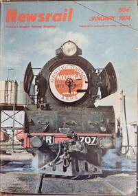
Magazine - Newsrail magazine, Victorian Division of the Australian Railway Historical Society, 1974
Newsrail is a monthly railway magazine covering the railways and tramways of Victoria. This publication was launched in January 1973 by the Australian Railway Historical Society's Victorian Division. It replaced the Divisional Diary magazine which had been published since November 1957. It includes features on both rural and metropolitan railways and contains articles and photographic presentations. Our collection includes all issues from January until December 1974. This featured item from January 1974 includes an article and photograph of the Northeast Railway Centenary celebration train, R707, to Wodonga. The magazine is still in publication in 2023.A magazine featuring articles and news items from the Australian Railway Historical Society's Victorian Division. Each issue is in the same format and includes a coloured photograph on the cover.non-fictionNewsrail is a monthly railway magazine covering the railways and tramways of Victoria. This publication was launched in January 1973 by the Australian Railway Historical Society's Victorian Division. It replaced the Divisional Diary magazine which had been published since November 1957. It includes features on both rural and metropolitan railways and contains articles and photographic presentations. Our collection includes all issues from January until December 1974. This featured item from January 1974 includes an article and photograph of the Northeast Railway Centenary celebration train, R707, to Wodonga. The magazine is still in publication in 2023.locomotive r707, newsrail magazine, wodonga railway centenary -
 Wodonga & District Historical Society Inc
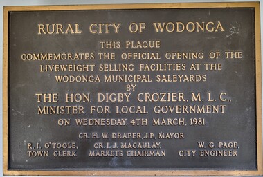
Plaque - Commemoration of the Opening of Liveweight Sales Wodonga Municipal Saleyards 1981
This plaque commemorates the official opening of the liveweight selling facilities at the Wodonga Municipal Saleyards, named the W. G. Page Saleyards, in 1980. Liveweight selling usually involves a curfew where cattle have to be at the saleyard by a specific time before the sale in order for them to be weighed prior to auction. Cattle that do not make the curfew time are sold on a $/head basis. The last sales at this facility took place in February 2015 before being replaced by the privately-run Barnawartha North's Northern Victoria Livestock Exchange. William George Page was Shire and City Engineer in Wodonga from 1965 until 1989. When he arrived the Shire of Wodonga had a population of 17,000 people. In 1966 Wodonga was selected as a city for special growth assistance. In 1972 Bill Page presented a new Town Plan to the Wodonga Council. Over the ensuing years he dedicated himself to bring this plan to fruition. He often had to argue and campaign with the Albury-Wodonga Corporation to push for the interests of development in Wodonga. This included winning a planning appeal to allow the saleyards to be relocated to Bandiana on the outskirts of Wodonga. Bill Page retired on health grounds in July 1989. The Council honoured him with a farewell dinner and renamed the saleyards at Bandiana the W.G. Page Saleyards in his honour.The Mayor , Cr Valentina Gillard, said "Every development in Wodonga in the past 24 years has a bit of Bill Page in it". William Page died 3 months later at 58 years old.A bronze forged metal plaque with detailed inscription. Bolts to fix plaque to the wall are still attached.RURAL CITY OF WODONGA / THIS PLAQUE/ COMMEMORATES THE OFFICIAL OPENING OF THE/ LIVEWEIGHT SELLING FACILITIES AT / THE WODONGA MUNICIPAL SALEYARDS /BY/THE HON. DIGBY CROZIER, M.L.C., / MINISTER FOR LOCAL GOVERNMENT/ ON WEDNESDAY, 4TH MARCH, 1981 CR. H. W, DRAPER, J.P. MAYOR R. I. O'TOOLE TOWN CLERK , CR. I. J. MACAULAY MARKETS CHAIRMAN W. G. PAGE CITY ENGINEERlivestock sales wodonga, liveweight cattle sales, municipal saleyards wondonga -
 Wodonga & District Historical Society Inc
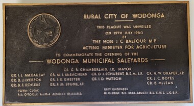
Plaque - Opening of Wodonga Municipal Saleyards 1980
This plaque commemorates the opening of the Wodonga Municipal Saleyards, named the W. G. Page Saleyards, in 1980. The last sales at this facility took place in February 2015 before being replaced by the privately-run Barnawartha North's Northern Victoria Livestock Exchange. William George Page was Shire and City Engineer in Wodonga from 1965 until 1989. When he arrived the Shire of Wodonga had a population of 17,000 people. In 1966 Wodonga was selected as a city for special growth assistance. In 1972 Bill Page presented a new Town Plan to the Wodonga Council. Over the ensuing years he dedicated himself to bring this plan to fruition. He often had to argue and campaign with the Albury-Wodonga Corporation to push for the interests of development in Wodonga. This included winning a planning appeal to allow the saleyards to be relocated to Bandiana on the outskirts of Wodonga. Bill Page retired on health grounds in July 1989. The Council honoured him with a farewell dinner and renamed the saleyards at Bandiana the W.G. Page Saleyards in his honour.The Mayor , Cr Valentina Gillard, said "Every development in Wodonga in the past 24 years has a bit of Bill Page in it". William Page died 3 months later at 58 years old.This plaque commemorates an important centre in the development and support of the livestock industry around Wodonga.A bronze plaque bearing the symbol of the Rural City of Wodonga in the upper left corner and an inscription to commemorate the opening of the Wodonga Municipal Saleyards. It includes a detailed inscription.RURAL CITY OF WODONGA / THIS PLAQUE WAS UNVEILED / ON 29TH JULY 1980 / BY /THE HON. J. C. BALFOUR M.P. / ACTING MINISTER FOR AGRICULTURE /TO COMMEMORATE THE OPENING OF THE / WODONGA MUNICIPAL SALEYARDS CR. G. R. CHAMBERLAIN, J.P. MAYOR CR. I . J. MACAULAY CR. M. J. McEACHERN CR. D. I. SCHUBERT, B'E'N', J.P CR. H. W. DRAPER, J.P. CR. D.J .IVERSON CR. E. E. CHESTER CR I. D. WATSON CR. L. C. BOYES CR. B. F. ROGERS CR. P. M. STONE. J.P CR. B. McLEAN TOWN CLERK R. I. O"TOOLE A.I.M.A., A.R.M.I.T, M.A.I.H.S CITY ENGINEER W. G. PAGE, B.E, M.I.E (AUST) B.S .E.W.S L. G. E. A saleyards wodonga, w. g. page saleyards, livestock sales wodonga -
 Wodonga & District Historical Society Inc
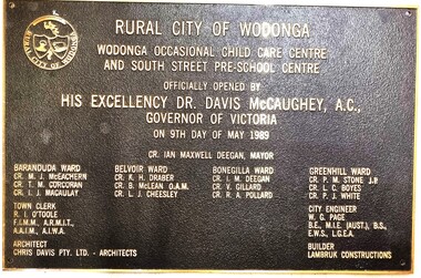
Plaque - Official Opening of the Child Care Centre & South Street Pre-School, Wodonga
This plaque commemorates the official opening of an occasional child care centre and pre-school in South St, Wodonga in 1989 by the Governor of Victoria Dr. Davis McCaughey. With strong population growth in Wodonga community services had expanded rapidly throughout the 1980s. The first child minding centre had opened in 1975. BY 1987 Upper Murray Family Care provided full-day family day care and occasional care and there were also 2 private child care centres. By 1986 there were 350 full-time places and 75 part-time places, but pre-schools were unable to fill the demand for another 511 applicants. This new facility helped to ease a little of the problem. As well as the inscription included here, the name of the Mayor, all members of the Wodonga Council, City Engineer, Architect and Builder are listed on the plaque.This item illustrates an important development in the provision of pre-school and child care services in Wodonga.A bronze rectangular plaque with detailed inscription, designed to be attached to the wall of a building. There is a hole in each corner for bolts to be inserted. The text is raised above the surface of the plaque. It features the symbol of the shield of the Rural City of Wodonga in the top left corner.fiction"RURAL CITY OF WODONGA WODONGA OCCASIONAL CHILD CARE CENTRE AND SOUTH STREET PRE-SCHOOL CENTRE OFFICIALLY OPENED BY HIS EXCELLENCY DR. DAVIS MCCAUGHEY, A.C., GOVERNOR OF VICTORIA ON 9TH DAY OF MAY 1989child care facilities wodonga, children's services wodonga, pre-schools wodonga -
 Wodonga & District Historical Society Inc
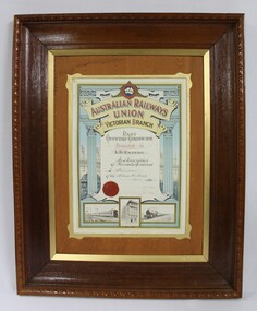
Certificate - Australian Railways Union, Victorian Branch, Past Officers Certificate, Wodonga Sub-Branch, 1926
The Wodonga line and train station opened in November 1873 when the section of the line from Wangaratta was completed. The expansion of the railways to the northeast of Victoria occurred after the Victorian Government took over the railways in 1867 and the trains serviced large towns such as Seymour, Wangaratta and Wodonga, as well as smaller towns along the way. The north- east train line to Wodonga remained a significant factor in the development of Wodonga as a rural city in the 20th century. The Past Officers Certificate has local significance as it was presented to Wodonga resident, Lachlan McEachern, who was President of the Wodonga Sub-Branch of the Victorian Branch of the Australian Railways Union, and there are other items that belonged to Mr Eachern in the collection of the Wodonga Historical Society. It also has wider significance as an example of a Past Officers certificate dated to the 1920s, as other examples in the collection of Museums Victoria are later and are dated to the 1930s, 1940s and 1950s. Dark brown wooden frame with a lighter brown wood and gold inner border on a Past Officers Certificate from the Victorian Branch of the Australian Railways Union, presented to L. McEachern in 1926, in recognition of services rendered as President of the Wodonga Sub-Branch. The certificate is a colour lithograph with black and white photolithograph images and a red embossed seal. The inscription on the certificate is surrounded by two Corinthian columns and a background illustration of a signal gantry at Flinders St Station. The signatures of the State President and State Secretary are faded. At the bottom of the certificate, there are black and white images of a suburban electric passenger train, "Unity Hall" which is the building where the Australian Railway Union offices were located and a steam train."AUSTRALIAN RAILWAYS UNION" "A.R.U" "AUSTRALIAN RAILWAYS / UNION / VICTORIAN BRANCH" "Presented to / L.McEachern / In Recognition / of Services Rendered / As President / of the Wodonga Sub-Branch /Year 1926" "State President / State Secretary"australian railways union, a.r.u., a.r. u. victorian branch, wodonga sub-branch, victorian railways, v.r., past officers certificate, flinders st station, railway unions, trade unions -
 Wodonga & District Historical Society Inc
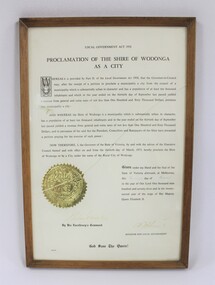
Certificate - Proclamation of the Shire of Wodonga as a City, 1973
The framed certificate proclaiming the Shire of Wodonga as a City in 1973 documents the development of Wodonga as an important rural city in the north east of Victoria. The decentralisation of industry and the establishment of international companies in Wodonga in the second half of the 20th century contributed to the growth of Wodonga as a major regional centre.The certificate proclaiming the Shire of Wodonga as a City in 1973 has local significance as it documents the history and development of Wodonga. It also has state significance as part of the history of the regional development of Victoria from the mid-20th century onwards.Thin wooden frame with gold trim around a certificate with the text in black proclaiming the Shire of Wodonga as a City dated to 1973. Embossed gold seal of the State of Victoria on the left side of the text in the lower part of the certificate. Signed by the Governor of Victoria, Sir Rohan Delacombe and the Victorian Minister for Local Government.wodonga shire, wodonga, rural cities in victoria, victorian state government certificates -
 Wodonga & District Historical Society Inc
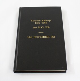
Administrative record - Victorian Railways Time Table 1910
The Wodonga line and train station opened in November 1873 when the section of the line from Wangaratta was completed. The expansion of the railways to the northeast of Victoria occurred after the Victorian Government took over the railways in 1867 and the trains serviced large towns such as Seymour, Wangaratta and Wodonga, as well as smaller towns along the way. The first section of the Wodonga to Tallangatta line opened in 1889 and was further extended in 1891. It was a vital community link until the passenger service closed in September 1961 The last regular goods train on the line ran on 21st April 1978. The north- east train line to Wodonga remained a significant factor in the development of Wodonga as a rural city in the 20th century. Local significance due to the importance of the railways to Wodonga as a means of transport, communication and impact on business and commerce. State and national significance due to the role played by the railways in opening up the country for development.A bound volume of the Victorian Railways Time Table for 2nd May 1910 to 30th November 1910. Black with gold inscription. The binding is not original but was carried out to preserve the contents"Victorian Railways/Time Table/ 2nd May 1910/ 30th November 1910"victorian railways, wodonga, timetable, transport -
 Wodonga & District Historical Society Inc
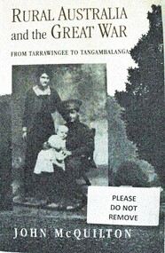
Book - Rural Australia and the Great War - From Tarrawingee to Tangambalanga, John McQuilton, 2001
This publication covers common issues of life in Australia during World War 1, such as recruitment, fundraising, conscription, homecomings and the construction of memorials. However it is unique in that these aspects of war are examined through a focus on rural communities in North Eastern Victoria. The first chapter describes the region and its towns at the outbreak of war, then discusses the fracturing impact of war on different groups within these communities. It paints an interesting social history at a critical time in Australia's development. John Quilton is a native of North Eastern Victoria, having been born in Yackandandah and educated in Tangambalanga and Wodonga. He was a senior member of the Bicentennial History Project at the University of New South Wales, and head of the History and Politics Program at the University of Wollongong.This book consists of 275 pages including photos and a map, as well as an extensive bibliography. The cover depicts a soldier and his family and a country town streetscape on the back.This publication covers common issues of life in Australia during World War 1, such as recruitment, fundraising, conscription, homecomings and the construction of memorials. However it is unique in that these aspects of war are examined through a focus on rural communities in North Eastern Victoria. The first chapter describes the region and its towns at the outbreak of war, then discusses the fracturing impact of war on different groups within these communities. It paints an interesting social history at a critical time in Australia's development. John Quilton is a native of North Eastern Victoria, having been born in Yackandandah and educated in Tangambalanga and Wodonga. He was a senior member of the Bicentennial History Project at the University of New South Wales, and head of the History and Politics Program at the University of Wollongong.world war 1, rural conditions australia 1914, world war 1 social conditions australia, tangambalanga world war 1 -
 Wodonga & District Historical Society Inc
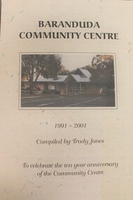
Booklet - Baranduda Community Centre 1991 - 2001, Trudy Jones
Baranduda is a rural area and, since the 1970s, a rural and residential locality formed under the authority of the Albury Wodonga Development Corporation. It is near the junction of Yackandandah Road and the Kiewa Valley Highway, 10 km south-east of Wodonga. This publication was compiled to celebrate the first 10 years of the Baranduda Community Centre. It documents the Centre's origins and anecdotes about its establishment and key personalities involved. Today it provides a variety of educational, recreational, leisure, cultural, social and community support programs including children's services, maternal and child health and immunisation clinics.non-fictionBaranduda is a rural area and, since the 1970s, a rural and residential locality formed under the authority of the Albury Wodonga Development Corporation. It is near the junction of Yackandandah Road and the Kiewa Valley Highway, 10 km south-east of Wodonga. This publication was compiled to celebrate the first 10 years of the Baranduda Community Centre. It documents the Centre's origins and anecdotes about its establishment and key personalities involved. Today it provides a variety of educational, recreational, leisure, cultural, social and community support programs including children's services, maternal and child health and immunisation clinics.baranduda communiity centre, baranduda -
 Wodonga & District Historical Society Inc
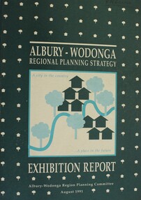
Book - Albury-Wodonga Regional Planning Strategy - Exhibition Report, Albury-Wodonga Planning Committee, August 1991
This report outlining the Albury-Wodonga Regional Planning Strategy was prepared as a component of a Ministerial Review of the ALbury-Wodonga Development Corporation. The Planning Committee included representatives of the N.S.W. and Victorian Planning Departments, the Albury-Wodonga Planning Corporation. the City of Albury, Rural City of Wodonga and Hume Shire Council and a representative of the four Victorian rural Councils of Beechworth, Chiltern, Tallangatta and Yackandandah.non-fictionThis report outlining the Albury-Wodonga Regional Planning Strategy was prepared as a component of a Ministerial Review of the ALbury-Wodonga Development Corporation. The Planning Committee included representatives of the N.S.W. and Victorian Planning Departments, the Albury-Wodonga Planning Corporation. the City of Albury, Rural City of Wodonga and Hume Shire Council and a representative of the four Victorian rural Councils of Beechworth, Chiltern, Tallangatta and Yackandandah.city planning wodonga, city planning albury, regional planning -
 Wodonga & District Historical Society Inc
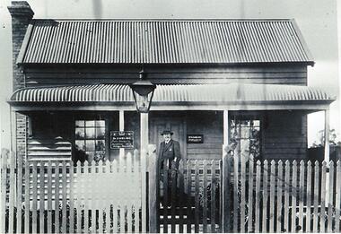
Photograph - Dr. W. H. Embling - Public Vaccinator
William Henry Embling was born in London on September 25, 1840, and came to Victoria with his parents when he was about 9 years old. When still in his teens, William was sent to Germany, and afterwards to England, to study for the medical profession. Whilst in London he became involved with the British Legion which sailed for Italy and fought in the Garibaldian campaign. He rose to the rank of Lieutenant. After moving to Glasgow to study for the Licentiate of the Royal College of Surgeons, William returned to Australia in 1863 and set up practice in St. Kilda, Victoria. Embling was appointed resident surgeon at Melbourne Hospital, practiced in Ballarat from 1866-1873 and was an honorary physician at the Alfred Hospital in 1877 In 1878 he was appointed to the Central Board of Health, and in this role travelled to many rural areas including Wodonga as the Public Vaccinator. For some time, he was regularly in Wodonga on Fridays. He was also Chairman of the Police Medical Board and President of the Working Men's College in Melbourne. In 1892 William Embling was elected as a member of the Legislative Council. One of the many roles he filled as a politician was as a member of the Parliamentary Standing Committee on Railways. In this role he also visited Wodonga when consultations were in progress for development of the new railways throughout Victoria. Dr. Embling died from pneumonia in St. Kilda, Victoria on 24 May 1912.This item is significant because it depicts a doctor who provided an important service to Wodonga and to the wider Victorian community.A black and white photograph of Dr. Embling standing in front of his consulting room in a house in Wodonga.Signs to left of door: Below Crown and Letters C. R. Dr Embling Public Vaccinator Vaccinations Every Friday Free Service To Right of Door: Dr Embling Surgeon dr. w. h. embling, wodonga medical services, public vaccinator wodonga -
 Wodonga & District Historical Society Inc
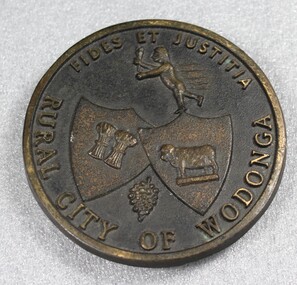
Plaque - Rural City of Wodonga Small Plaque
The current city was originally named Wodonga, but its name was changed to Belvoir then later back to Wodonga, its indigenous name. The original post office opened on June 1, 1856. Wodonga Shire was created in 1876 when the colonial government agreed to ratepayers' petitions to have their part severed from the Yackandandah Shire and form a new municipality. On 30th March 1973, the Wodonga Shire was granted rural city status and was officially named the Rural City of Wodonga by the Governor of Victoria, Sir Rohan Delacombe. The date this logo first came into use is unsure, but it was used prior to the granting of rural city status. In 1994, the name was retained in a new local government authority and so the Wodonga Rural City Council was born. In 1995 it was decided to give the city a fresh image, so the term 'rural' was be dropped from use except where there was a legal requirement. In December 2003, it was decided to rename the council removing the term "rural" and it is now legally Wodonga City Council.This plaque is of local historic significance as it documents the way in which the local government and community has evolved and depicts itself over time. Designation as a rural city was a critical event in the development of Wodonga.Small circular metal plaque for public display of status of Rural City of Wodonga. Inscription including the Latin terms for "Faith and Justice" are embossed around the circumference on the front of the plaque. The symbols of wheat, cattle and grapes represent the major agricultural pursuits of the area. A representation of Hermes/Mercury is at the top centre of the plate.Around the circumference of the plaque is the inscription "FIDES ET JUSTITIA / RURAL CITY OF WODONGA"local government, wodonga council logo, wodonga, rural city victoria -
 Wodonga & District Historical Society Inc
Memorabilia - Wine Glass Rural City of Wodonga, C. 1973 - 2000
Wodonga Shire was created in 1876 when the colonial government agreed to ratepayers' petitions to have their area severed from the Yackandandah Shire and form a new municipality. In 1973, the Wodonga Shire was granted rural city status and was officially named the Rural City of Wodonga by the Governor of Victoria, Sir Rohan Delacombe. In 1994, a new local government authority, the Wodonga Rural City Council was created. In December 2003, the council was again legally re-named to become Wodonga City Council.The glass is representative of memorabilia produced to celebrate the achievement of a special status in the development of local government in Wodonga. Wodonga had "Rural City" status from 1973 until 2003.A standard wine glass with a gold trim and bearing the logo of the Rural City of WodongaAround the edge of the logo "RURAL CITY OF WODONGA / FIDES ET JUSTITIA"wodonga, local government, rural city, souvenir wodonga -
 Wodonga & District Historical Society Inc
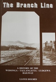
Book - The Branch Line : A history of the Wodonga - Tallangatta - Cudgewa Railway, Lloyd Holmes, 1985
This railway story concerns just one of the many branch lines that snaked across the landscape of Victoria. This book concentrates on the Wodonga - Tallangatta - Cudgewa line, a railway that took 32 years to complete from starting point to eventual terminus. The first section of the Wodonga to Tallangatta line opened in 1889 and was further extended in 1891. It was a vital community link until the passenger service closed in September 1961. The last regular goods train on the line ran on 21st April 1978. The north- east train line to Wodonga remained a significant factor in the development of Wodonga as a rural city in the 20th century.non-fictionThis railway story concerns just one of the many branch lines that snaked across the landscape of Victoria. This book concentrates on the Wodonga - Tallangatta - Cudgewa line, a railway that took 32 years to complete from starting point to eventual terminus. The first section of the Wodonga to Tallangatta line opened in 1889 and was further extended in 1891. It was a vital community link until the passenger service closed in September 1961. The last regular goods train on the line ran on 21st April 1978. The north- east train line to Wodonga remained a significant factor in the development of Wodonga as a rural city in the 20th century.railroads -- victoria, northeastern victoria, tallangatta, wodonga railways, cudgewa railroad -
 Wodonga & District Historical Society Inc
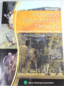
Book - Wodonga Retained Environment Network, Albury-Wodonga Development Corporation, 2006
A threatened species and habitat conservation strategy prepared for the Albury Wodonga Corporation and the Rural City of Wodonga,non-fictionA threatened species and habitat conservation strategy prepared for the Albury Wodonga Corporation and the Rural City of Wodonga,endangered species -- victoria, conservation albury wodonga, threatened species victoria, threatened habitats, environmental protection -
 Wodonga & District Historical Society Inc
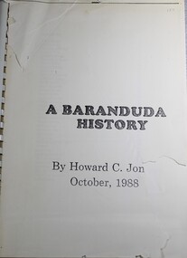
Book - A Baranduda History, Howard C Jones, 1988
A history of Baranduda in Northeast Victoria. Baranduda is a rural area and, since the 1970s, a rural and residential locality formed under the authority of the Albury Wodonga Development Corporation. It is near the junction of Yackandandah Road and the Kiewa Valley Highway, 10 km south-east of Wodonga. This publication traces the history of the area from its earliest know indigenous inhabitants, through the days of the earlier establishment of pastoral runs to more recent developments.Spiral boundnon-fictionA history of Baranduda in Northeast Victoria. Baranduda is a rural area and, since the 1970s, a rural and residential locality formed under the authority of the Albury Wodonga Development Corporation. It is near the junction of Yackandandah Road and the Kiewa Valley Highway, 10 km south-east of Wodonga. This publication traces the history of the area from its earliest know indigenous inhabitants, through the days of the earlier establishment of pastoral runs to more recent developments.baranduda, pioneers victoria, huon family, wodonga pioneers -
 City of Kingston
Photograph - Black and white, Percy Fairlam, c. 1910
Black and white image of Cheltenham in the early 20th Century depicts an almost idyllic life. This photo was taken by Percy Fairlam, who climbed a tall pine tree to achieve the aerial view. The tree was a well recognised feature of the Cheltenham skyline but was cut down some time before World War II.Cheltenham was established as a rural market gardening community. The development of the railway was crucial to the ongoing development of the area. Community life sprung up around the railway line which is evident in the proximity of shopping and leisure.Black and white image depicting aerial view down Charman Road, Cheltenham, including the unsealed road, level crossing and shopping centre. What appears to be a cricket pitch is located behind the shops.Handwritten in black ink on a red round sticker adhered to the reverse, and then crossed out: X14 Handwritten in blue ink on reverse: A8 Handwritten in red ink on reverse: 85%cheltenham, railway crossing, roads, housing, shopping strip -
City of Kingston
Photograph - Colour, 31 January 1993
Patterson Lakes is a suburb in the City of Kingston that is built one kilometre upstream of the mouth of the Patterson River. The area is bordered by the Patterson River and Eel Race Drain which enters the Kananook Creek. The suburb consists predominantly of newer housing developments and the tidal canal system of the development joins Port Phillip Bay. Patterson Lakes and the Kananook Creek were previously part of the extensive Carrum Carrum Swamp. The area was once a source of fish and eels for the Mayone-Bulluk clan of the Bunurong people. Over time the area was drained and in 1973 investigations commenced into the development of a unique residential area that would be built adjacent to canals and waterways. It was originally proposed to be known as "Gladesville". The development would give the suburb's homeowners access to Port Phillip Bay "from their back door". Circa 1974, the area was rezoned from rural to residential and named Patterson Lakes. Development has been continuous since the 1970s with construction of residential housing, schools, shopping centres, marinas, a hotel and library.Laminated colour aerial photograph of the Carrum and Patterson Lakes region within City of Kingston. This 1993 image includes Patterson River Secondary College, Roy Dore Reserve, Kananook Creek and Nepean Highway. The railway line can be seen as it veers inland from Eel Race Road, Seaford. The section of Ocean Reef Drive and Palm Beach Drive in Patterson Lakes appears to be a recent development with many spare blocks and new houses under construction.Black typed lettering on white adhesive label: 31.1.93 Black typed lettering on white adhesive label: 27E/7140 31/1/93 12.55 pm Black typed lettering on white label: 7140 Yellow round adhesive label located on left sidepatterson lakes, seaford, kananook creek, carrum carrum swamp, canals and waterways -
 City of Kingston
Photograph - Black and white, c. 1950
While the road is sealed, there is evidence of potholes that have been filled, and the wide, gravel shoulder has long grass running into the gutter of the nature strip. On the other side of the road, extremely long grass can be seen growing on the side of the road. There is a truck visible on the road, which indicates the rural nature of the Cheltenham community in the 1950s.This image is one of many in the collections that focuses on the railway or roads. The development of roads and the railway was crucial to the ongoing development of the area. Black and white photograph of the intersection of Warrigal and Centre Dandenong roads, Cheltenham. On the left hand side is a small sign warning of a cross roads intersection. Housing and shops line the road.Handwritten in blue ink on reverse: 219 Handwritten in red ink on reverse: 80%cheltenham, roads, suburbs -
 City of Kingston
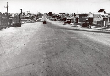
Photograph - Black and white, 1950
This photograph depicts the increasing urbanisation of a once rural area at Moorabbin.This image is one of many in the collections that focuses on either roads or the railway. The development of roads and the railway was crucial to the ongoing development of the area. Black and white photograph of South Road, Moorabbin, with Station Street to the right and Jasper Road further down to the left. Along both sides of the road are retail spaces which become homes on the left hand side, after Jasper Road.Handwritten in red ink on reverse: 80% Handwritten in blue ink on reverse: 216moorabbin, roads, cars, shopping strip, housing -
City of Kingston
Photograph - Colour, c. 1993
Patterson Lakes is a suburb in the City of Kingston that is built one kilometre upstream of the mouth of the Patterson River. The area is bordered by the Patterson River and Eel Race Drain which enters the Kananook Creek. The suburb consists predominantly of newer housing developments and the tidal canal system of the development joins Port Phillip Bay.Patterson Lakes and the Kananook Creek were previously part of the extensive Carrum Carrum Swamp. The area was once a source of fish and eels for the Mayone-Bulluk clan of the Bunurong people. Over time the area was drained and in 1973 investigations commenced into the development of a unique residential area that would be built adjacent to canals and waterways. It was originally proposed to be known as "Gladesville". The development would give the suburb's homeowners access to Port Phillip Bay "from their back door". Circa 1974, the area was rezoned from rural to residential and named Patterson Lakes. Development has been continuous since the 1970s with construction of residential housing, schools, shopping centres, marinas, a hotel and library.Laminated colour aerial photograph of the Carrum and Patterson Lakes region within City of Kingston. This 1993 image includes Patterson River Secondary College, Roy Dore Reserve, Kananook Creek and Nepean Highway. The railway line can be seen as it veers inland from Eel Race Road, Seaford. The section of Palm Beach Drive, Curlew Point Drive, Snapper Point Drive, Clipper Island and Myola Street in Patterson Lakes appears to be a recent development with many spare blocks and new houses under construction.patterson lakes, seaford, kananook creek, carrum carrum swamp, canals and waterways -
City of Kingston
Photograph - Colour, 29 January 1993
Bonbeach, Carrum and Patterson Lakes are suburbs in the City of Kingston. Bonbeach and Carrum were holiday destinations in early 20th century and over time the housing has converted to permanent residential structures. In Patterson Lakes, the area consists predominantly of newer housing developments and the tidal canal system which is accessible to many dwellings joins Port Phillip Bay.Bonbeach, Carrum and Patterson Lakes were previously part of the extensive Carrum Carrum Swamp. The area was once a source of fish and eels for the Mayone-Bulluk clan of the Bunurong people. Over time the area was drained and this allowed farming at Carrum and Bonbeach, although the area was prone to flooding. In the early 1920s and 30s the land was converted to residential dwellings. In 1973 investigations commenced nearby to Bonbeach and Carrum into the development of a unique residential area comprising canals and waterways. It was originally proposed to be known as "Gladesville". Circa 1974, the area was rezoned from rural to residential and named Patterson Lakes. Development has been continuous since the 1970s with staged construction of the waterways, residential housing, and supporting infrastructure and facilities.Laminated colour aerial photograph of the Bonbeach, Carrum and Patterson Lakes region within City of Kingston. This 1993 image includes Bonbeach High School prior to demolition, Bonbeach Primary School and Patterson River Golf Club. Sections of Patterson Lakes are not yet developed, including Rhode and Staten Islands. Long Island Point appears to be a recent development with many spare blocks and new houses under construction. The Patterson River marina is prominent and the river mouth as it meets Port Phillip Bay. The Carrum railway station is visible.Black type on white adhesive sticker: No. 6661 Black type on white adhesive sticker: 26E/6661, 29/1/93, 4.25 pm Black type on white adhesive sticker 29-1-93 Yellow circular adhesive stickerbonbeach, carrum, patterson lakes, patterson river, carrum carrum swamp, canals and waterways -
 City of Kingston
Photograph - Black and white, 20 December 1945
This aerial photograph depicts the changing landscape of Cheltenham and Highett since WWII. Photographed in 1945, there is a mix of urban dwellings and industrial development and precedes the major transformation of Cheltenham with the development of the Southland shopping centre in the 1960s and expansion in the 1990s.A large part of Cheltenham was originally established as a rural market gardening community. The railway line and station brought urban development to the area and in the north, the Highett area was dominated by the Highett Gas Works. Cheltenham became a major destination for shopping in the 1960s with the opening of Southland.Aerial photograph taken in 1945 of Cheltenham and Highett within the City of Kingston. The image includes the Highett Reserve, (top right), the Methodist Children Homes (now Southland), Nepean Highway and Jamieson Street. Highett Gas Works is visible in the top left and the land now named William Fry Reserve at the intersection of Bay Road and Nepean Highway. A visible large parcel of land on the corner of Bay Road and Nepean Highway was developed in the 1990s as the west side addition to Southland. The densely vegetated area in the upper right sector of the image is now dense with housing. Tulip Grove, Heather Grove and Gilford Street are visible bottom left. This image is possibly from the collection of aerial photographs commissioned by the Department of Crown Lands and Survey and taken by Adastra Airways.Black ink: 57252 White lettering: VIC-10 57252 20.12.45 [lens information indecipherable] PROJ. No.5 MELB. METROP AREA Black pencil: 80highett, cheltenham, highett gas works, urbanisation -
 City of Kingston
Photograph - Black and white, 20 December 1945
This aerial photograph depicts the changing landscape of Cheltenham and Highett since WWII. Photographed in 1945, there is a mix of urban dwellings and industrial development and precedes the major transformation of Cheltenham with the development of the Southland shopping centre in the 1960s and expansion in the 1990s.A large part of Cheltenham was originally established as a rural market gardening community. The railway line and station brought urban development to the area and in the north, the Highett area was dominated by the Highett Gas Works. Cheltenham became a major destination for shopping in the 1960s with the opening of Southland.Aerial photograph taken in 1945 of Cheltenham and Highett within the City of Kingston. The image includes the Highett Reserve, (top right), the Methodist Children Homes (now Southland), Nepean Highway and Jamieson Street. Highett Gas Works is visible in the top left and the land now named William Fry Reserve at the intersection of Bay Road and Nepean Highway. A visible large parcel of land on the corner of Bay Road and Nepean Highway was developed in the 1990s as the west side addition to Southland. The densely vegetated area in the upper right sector of the image is now dense with housing. Tulip Grove, Heather Grove and Gilford Street are visible bottom left. This image is possibly from the collection of aerial photographs commissioned by the Department of Crown Lands and Survey and taken by Adastra Airways.Black type: Reverse lettering VIC-10 57252 20.12.45 [lens information indecipherable] PROJ. No.5 MELB. METROP AREA White lettering: Reverse writing 57252cheltenham, highett, highett gas works, urbanisation -
City of Kingston
Photograph - Black and white, 3 March 1954
Cheltenham and Moorabbin are suburbs within the City of Kingston that were originally established as rural market gardening communities The area is bordered by Highett and Mentone. The market gardens, farms and paddocks have gradually been sub-divided into housing and industrial estates. Highett is developed with residential homes but was also the site of major facilities such as the Highett Gas Works. This aerial image covers a diverse section of the City of Kingston, taking in the suburbs of Moorabbin, Cheltenham, Highett and Mentone Residential housing development is prominent along the Frankston Railway line and the area still retains extensive market gardens and paddocks yet to be converted to a large industrial and commercial zone.Aerial photograph of Mentone, Cheltenham and Moorabbin within the City of Kingston. The area depicted in this 1954 aerial view includes Warrigal Road and Centre Dandenong Road intersection (top left); Charman Road, Patty Street, Bourke Street, Collins Street Mentone (top right); Keys Road Moorabbin (bottom left); Bay Road, Cheltenham (bottom right), Friendship Square, Cheltenham Park, Victoria Golf Club and Jack Barker Oval are visible. Nepean Highway and the Frankston railway line run centrally through the image. Highett Gasworks is also evident.White handwriting and type [indecipherable]. White image of clockface White image of compass White type 42956 Black handwriting 3/3/54 Williams [indecipherable] Black pencil: S [arrow] Black ink: 3/3/1954cheltenham, moorabbin, mentone, highett, market gardens -
City of Kingston
Photograph - Black and white, 20 December 1945
This photograph depicts a section of Cheltenham with a mix of housing and market gardens. The visible market gardens, farms and paddocks have gradually been sub-divided into housing, commercial and industrial estates. A large part of Cheltenham was originally established as a rural market gardening community. The railway line and station brought urban development to the area and the gradual subdivision of farmland and large land holdings for the development of housing. Aerial photograph dated 1945 of the Cheltenham area in the City of Kingston. Sydney Street (bottom left); Sinclair Street (top left); Weymar Street area off Wilson Street, Charles Street (botton right).White print VIC-170; 57197; RUN5; PROJ.No.5; MELB.METROP AREA Lens information [indecipherable] Small photograph: clockface Black ink: 57197cheltenham, market gardens, urbanisation