Showing 1254 items matching "sale of land"
-
 Bendigo Historical Society Inc.
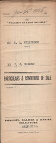
Document - H.A. & S.R. WILKINSON COLLECTION: CONDITION OF SALE
... and conditions of sale of freehold land, particulars: the surface... of sale issued by Smalley, Balmer & Davies solicitors, Swan Hill ...Conditions of sale issued by Smalley, Balmer & Davies solicitors, Swan Hill and dated 24th January 1925 between H. A. Wilkinson as seller and J. G. Walker as buyer. Particulars and conditions of sale of freehold land, particulars: the surface and down to a depth of fifty feet below the surface of all that piece of land being part of Crown Allotment 6 Suburban Section 2 town of Swan Hill, Parish of Castle Donnington County of Tatchera and being the whole of the land described in certificate of title volume 4390 folio 877911. Price 400 pounds.organization, business, h.a. & s.r wilkinson real estate -
 Melbourne Tram Museum
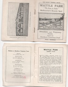
Ephemera - Timetable, Hawthorn Tramways Trust (HTT), "Directory and Tramway Guide issued by the Hawthorn Tramways Trust", 1918
... and Kindle for the sale of land at Riversdale Heights and a map..., Hamilton and Kindle for the sale of land at Riversdale Heights ...Booklet - 38 pages, printed on off white page, centre stapled, titled "Directory and Tramway Guide issued by the Hawthorn Tramways Trust", specifically advertising Wattle Park and showing Princes Bridge and the Yarra on the front cover and a photo of Hawthorn depot on the rear cover. Gives details of Wattle Park, its opening, many photos, members of the Trust, Engineer and Manager and Acting Secretary, Stopping points for the round and fares to Wattle Park, section fares, maps of the tram routes and connections with other tramways and railway stations. Has timetables for Burnley and other major points, special and emergency services, the coloured lights used on the trams, and a map for land sales at Riversdale Heights estate. Advertisements for Mutual stores, Melbourne Electric Supply Co., Moule, Hamilton and Kindle for the sale of land at Riversdale Heights and a map showing the estate location. Both copies have alterations or corrections to the route signage letters - marked in red - from the Minutes of the HTT Board meetings, the Trust were not happy with the finished product and was reluctant to pay for them - see Minutes of Meeting No. 99 of 5-7-1918. Two copies held - one with red marks on the front cover.trams, tramways, htt, wattle park, princes bridge, hawthorn depot, timetables, mesco, real estate -
 Warrnambool and District Historical Society Inc.
Legal record - Warrnambool City Council
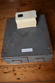
... Council and contain information on land sales and sub-divisions... Council and contain information on land sales and sub-divisions ...These items are original records from the Warrnambool City Council and contain information on land sales and sub-divisions within the city area for the second half of the 20th century. The ledger contains the names of those involved in the sale and transfer of land and the file cards give illustrative details of the allotments – plans, maps etc. These items are of considerable significance as they are Warrnambool City Council records dealing with land sales and sub-divisions in the second half of the 20th century. They will be useful for research. .1 A metal-bound ledger with a dark red leather cover and pages printed with red and blue lines. There are red alphabetical tabs with gold print attached to the outer edges of the pages. The entries are handwritten in blue ink. .2 A grey metal cabinet, rectangular in shape and rusted on the base. The cabinet has two drawers with handles and these drawers contain file cards. The cards have a negative or transparency inserted into the top corner. .3 File cards with a negative inserted and a green backing .4 File cards similar to .3 above but of a different size. .5 A packet of unused file cards with tabs land sales and sub-divisions, warrnambool city council -
 Ringwood and District Historical Society
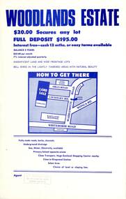
Flyer, Land Sale Advertisement - Woodlands Estate, North Ringwood, Victoria - circa 1970
... Land Sale Advertisement - Woodlands Estate, North Ringwood...Double sided single-page advertisement for land sale... advertisement for land sale with locality map and layout of Woodlands ...Double sided single-page advertisement for land sale with locality map and layout of Woodlands Estate subdivision in North Ringwood, with summary of local features and services. No indication of date of flyer other than post-Eastland Shopping Centre opening in 1967.Subdivision includes Oban Road, Terrigal Close, Dorelaw Drive (later Melview Drive), Naroo Court, and Barook Court. Agent's rubber stamp imprint - H.C. Walton & Son, 264 Doncaster Road, North Balwyn. -
 Kew Historical Society Inc
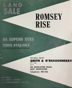
Plan - Subdivision Plan, Romsey Rise, Doncaster East
... Real estate brochure for a land sale of 86 sites in East... estate brochure for a land sale of 86 sites in East Doncaster ...Real estate brochure for a land sale of 86 sites in East Doncaster. Roads identified in the plan include: George Street, Dennert Street, Worthing Avenue, Sandhurst Street, Belinda Crescent, and Romsey Rise.Historic subdivision plan of a Doncaster East EstateFour page colour real estate brochure including on page 2 a subdivision plan for the Romsey Rise estate in East Doncaster. This record also includes a separate price list for the lots.real estate plans, subdivision plans - doncaster east, romsey rise estate - doncaster east (vic) -
 Bendigo Historical Society Inc.
Document - H.A. & S.R. WILKINSON COLLECTION: CONDITION OF SALE
... Conditions of sale of freehold land & dwelling by private... of sale of freehold land & dwelling by private contract dated 2nd ...Conditions of sale of freehold land & dwelling by private contract dated 2nd April, 1930, issued by T.C. Watts 7 Son licensed Real Estate Agents between R. Fletcher and T.G. Fletcher executors of the will of R.H Fletcher deceased (sellers) and J. Prior (buyer) for land being Crown allotment 5 section 24 at Eaglehawk having frontage to Campbell Street of 85 links by a depth along Church Street of 223.5 links, land described in certificate of title volume 1541 folio 308073, together with all buildings and erection thereon. Price 415 pounds.organization, business, h.a. & s.r wilkinson real estate -
 Ringwood and District Historical Society
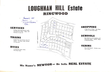
Document - Folder, Subdivision Map - Loughnan Hill Estate, Ringwood, Victoria - circa 1960
... Open centre page of land sale brochure glued to manilla... for further sale information) Open centre page of land sale brochure ...Open centre page of land sale brochure glued to manilla folder. Map of residential and shop sites in Burlock Road (later Burlock Avenue), Adolphson Avenue and Felix Crescent, Ringwood, with summary of estate facilities and local services. Agent - T.G. Newton.(Page glued to manilla folder prevents access to front page for further sale information) -
 Whitehorse Historical Society Inc.
Document, Robert Collier Land, 1903
... and receipt from Maddock & Jamison for services relating to above sale... to above sale and to purchase of land in Tunstall from Freehold... to above sale and to purchase of land in Tunstall from Freehold ...50 acres and house in Canterbury Road Blackburn to I.N. Cuttle for (pounds)590Papers relating to land dealings by Robert Collier of Springvale Road Tunstall. 50 acres and house in Canterbury Road Blackburn to I.N. Cuttle for (pounds)590collier, robert, t.r.b morton & coghill, maddock & jamison, canterbury road blackburn, freehold investment company of australia ltd -
 Ringwood and District Historical Society
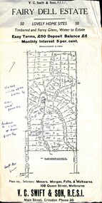
Flyer, Residential Land Sale Sub-division - Fairy Dell Estate, Warranwood, Vic. - circa 1950s
... Residential Land Sale Sub-division - Fairy Dell Estate...Land sale advertisement for 50 home sites with map of Sub... layout of Sub-division. Residential Land Sale Sub-division ...Land sale advertisement for 50 home sites with map of Sub-division showing layout of streets and allotments, summary of local features and services and terms of sale, and copy of sectional map of Crown Allotments 20 & 21B Parish of Warrandyte also showing layout of Sub-division.Subdivision includes Grandview Grove (later Bemboka Road), Merrill Crescent and Kerry Road, Warranwood. Estate Agents - V.C. Swift & Son R.E.S.I., Main Street, Croydon, Phone 20. Solicitors - Morgan, Fyffe & Mulkearns, 108 Queen Street, Melbourne. Handwritten 1970s real estate price notations for some blocks. -
Southern Sherbrooke Historical Society Inc.
Map - photocopy, Woodcock & McCormack, civil engineers & architects & surveyors, The Major Estate, Belgrave
... A photocopy taken from the original land sale map provided... A photocopy taken from the original land sale map provided ...A photocopy taken from the original land sale map provided to the society through Karel Coxell of Stockdale & Leggo. The original maps are stored in large bound account books and were originally the propert of McNally Real Estate. The books are held (in 22 A3 sheets. Shows The Serpentine between Government Rd (now Sandells Rd) and Government Rd(now Terrys Ave), Belgrave. Arrows to Belgrave, Sherbrooke Falls, Main Rd and store.land sales, advertisement, real estate subdivision, t. mahoney -
Southern Sherbrooke Historical Society Inc.
Map - photocopy
... A photocopy taken from the original land sale map provided... A photocopy taken from the original land sale map provided ...A photocopy taken from the original land sale map provided to the society through Karel Coxell of Stockdale & Leggo. The original maps are stored in large bound account books and were originally the propert of McNally Real Estate. The books are held (in 2A3 photocopy of plan of survey of part of Crown Allotments 20 & 21, section C, parish of Narre Worran, County of Mornington. Clements Ave and environs in Belgrave Heights"Villette Estate" in top LH corner, "Locality Plan" in bottom LH corner, "Not in sale" written on one block and crossed out. All handwritten in pencil on original. "Colby Drive " and "Verona Street" added in pencil to copy.land sales, advertisements, subdivision -
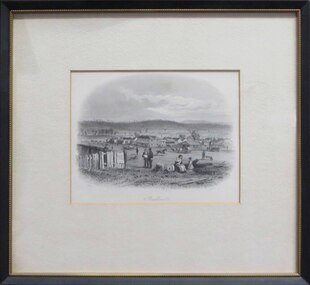 Federation University Historical Collection
Artwork, other - Artwork (framed), Sandhurst by S.T. Gill, 1857
... on a paper. A sign on the fence declares 'Gov Sale Land'. In the mid... on the fence declares 'Gov Sale Land'. In the mid ground a fledgling ...Sandhurst is the early name for the Victorian goldfield town of Bendigo. The original was published by Melbourne's Sands and Kenny Melbourne in 1857, and the plate from "Victoria Illustrated" by S.T. Gill. Balck and white steel engraving of a work by Samuel Thomas Gill showing a scene in early Bendigo. In the foreground a woman sits on a fallen tree holding a baby and talking to a small girl, while two men stand nearby discussing words on a paper. A sign on the fence declares 'Gov Sale Land'. In the mid ground a fledgling townscape is evident whole a man rides a horse along a thoroughfare, along with a small bullock team, and a man pushing a wheelbarrow. The scenefeatures a large number of flagpoles, and tents are visible along the horizon line. The image is engraved "S.T.Gill, del." in the lower left; "J. Tingle sc" in the lower right, and the title is engraved below image. bendigo, sandhurst, samuel thomas gill, s.t. gill, j. tingle, goldfield, bullock team, horse and rider -
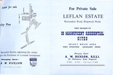 Ringwood and District Historical Society
Document - Folder, Land Sale - Leflan Estate, North Ringwood, Vic. - circa 1967
... Land Sale - Leflan Estate, North Ringwood, Vic. - circa...Bi-fold land sale advertisements for stages 1 and 3...-7016, After hours 870-6868. Bi-fold land sale advertisements ...Bi-fold land sale advertisements for stages 1 and 3 releases of residential allotments in Leflan Estate, Ringwood North, circa 1965-1967. Brochures include area map, layout of the estate, and summary of local facilities and services, with separate attachment listing lot number prices for 2nd and 3rd releases.Subdivision includes Melview Drive, Leslie Grove, Leflan Close, Warrandyte Road and Lockhart Street. Agent - A.W. Dickson, R.E.S.I., 136 Whitehorse Road, Ringwood. (Phone) 870-6007, 870-7016, After hours 870-6868. -
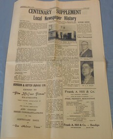 Bendigo Historical Society Inc.
Newspaper - McIvor Times Supplement
... months 40,000 men had rushed to the scene. The first land sale... had rushed to the scene. The first land sale occurred ...The "McIvor Times" first published 29 issues in 1863. In 1852 gold was discovered along the McIvor Creek and within six months 40,000 men had rushed to the scene. The first land sale occurred in January 1854, and the town was named Heathcote. By 1854 the majority of miners had moved on.A sixteen pages supplement to the McIvor Times. Published Wednesday, April 3, 1963, titled Centenary Supplement local newspaper history. Aileen and John Ellison Collection.local newspaper, mcivor times, heathcote -
 Bacchus Marsh & District Historical Society
Map, Plan of the second portion of the property of Messers Atkins and Clarke situate at Bacchus Marsh 1856
... This plan of land allotments for sale indicates part... for sale. The subdivided land shown was owned by John Aitkins...This plan of land allotments for sale indicates part ...This plan of land allotments for sale indicates part of the property once owned by the Bacchus family in and around the township area of Bacchus Marsh. The Bacchus family sold their property in Bacchus Marsh to John Aitkins and Robert Nalder Clarke in March 1851. Aitkins and Clarke kept the property for a number of years until April 1856 when these allotments were put up for sale.This is a very early land sales plan for agricultural land close to the township of Bacchus Marsh. It therefore provides some clues as to how the early urban development of the township and agricultural development of the nearby area took place. Upon seeing the map in 1911 Bacchus Marsh Express newspaper editor Christopher Crisp wrote "The sale appears to have created the present township, which had a nucleus in earlier times further east", Express, 30 September, 1911, page 3.A single page paper plan showing allotments of land for sale. The subdivided land shown was owned by John Aitkins and Robert Nalder Clarke, but previously owned by the Bacchus Family and was in and around their Manor House (Mansion) property in Bacchus Marsh. This plan shows allotments in the second portion of land to be sold which was located east of the Manor House on the eastern side of the Lerderderg River. The land for sale was made up of 15 allotments. The plan is pasted into a bound volume containing 76 maps or plans in total. BMDHS Loc: AR/B12/S4 Bacchus Marsh Township and Nearby Districts Maps Volume In-house Digital copies: BMDHS, Computer Network: Maps\Bacchus Marsh Township and Nearby Districts Maps Volumebacchus marsh victoria maps, bacchus family, land sales, manor house bacchus marsh -
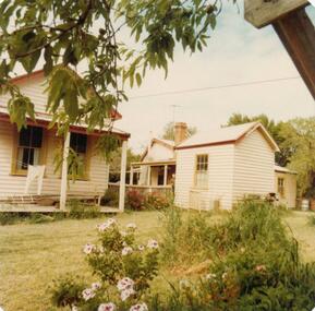 Phillip Island and District Historical Society Inc.
Photograph, 1978/9
... arrived on Phillip Island in 1868 when the first land sale took... when the first land sale took place. Charlie, William's son ...The house was built by William Richardson who went to live at Rhyll in 1876. His father, Joseph, owned the land. Joseph had arrived on Phillip Island in 1868 when the first land sale took place. Charlie, William's son, grew up in the house with his parents, brothers and sisters.Coloured photograph showing the kitchen at William Richardson's house in Rhyll.local history, photographs, buildings - historical, housing, coloured photograph, john cook, phillip island, charlie richardson -
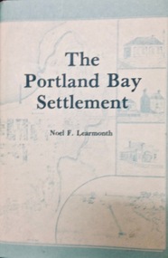 Port Fairy Historical Society Museum and Archives
Book, The Historical Committee Of Portland, The Portland Bay Settlement, 1934
... including "List of Purchasers at original land sale", "First..., appendices including "List of Purchasers at original land sale ...Aboriginal resistance to settlement, Native Police Force, G.A. Robinsons proposal to re-settle Flinders Island people and extracts fom his 1841 expedition report. Contents I. The early navigators and explorers II. Sealers and whalers and tales of the sea III. The Hentys and Victoria's first permanent settlement IV. Early incidents and personalities V. Under government control Vi. Social life and activities VII. The story of the press VIII. Business, professions and industry IX. Hotels and roads X. Sport XI. Environs of Portland XII. Miscellaneous historical items.8vo; pp. x, 285; frontispiece, numerous b/w illustrations, plans and maps two of which are folding, index, appendices including "List of Purchasers at original land sale", "First Election List", "Subscription lists for both First Church of England and First Presbyterian Church", original blue cloth, title in gilt on spinenon-fictionAboriginal resistance to settlement, Native Police Force, G.A. Robinsons proposal to re-settle Flinders Island people and extracts fom his 1841 expedition report. Contents I. The early navigators and explorers II. Sealers and whalers and tales of the sea III. The Hentys and Victoria's first permanent settlement IV. Early incidents and personalities V. Under government control Vi. Social life and activities VII. The story of the press VIII. Business, professions and industry IX. Hotels and roads X. Sport XI. Environs of Portland XII. Miscellaneous historical items.robinson, george augustus, 1791-1866., government policy - initial period and protectionism - 1788-1850., government policy - state and territory - victoria., law enforcement - police - native police., race relations - violent - massacres, murders, poisonings etc. - to 1900., sport., pioneers -- victoria -- portland., portland (w vic sj54-11), portland (vic.) -- history., book -
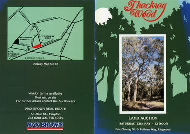 Ringwood and District Historical Society
Flyer, Land Auction Brochure - Thackray Wood, Ringwood East - circa 1984
... Double sided bi-fold sales brochure regarding sale of 14... of additional copy with handwritten sale prices. Land Auction Brochure ...Double sided bi-fold sales brochure regarding sale of 14 blocks of land comprising Thackray Wood, corner Cheong Street and Ruthven Way, Ringwood East. Agent: Max Brown Real Estate, 53 Main Street Croydon, Tel 7230281 a.h. 8764034. Inset image of additional copy with handwritten sale prices. -
Kew Historical Society Inc
Archive (series) - Subject File, Kew Bowling Club (Vic), 1980
... relate to the proposed sale of the land by Boroondara Council... relate to the proposed sale of the land by Boroondara Council ...Various partiesReference, Research, InformationSecondary valuesSubject file on the former Kew Bowling Club (Vic), founded in 1880 and amalgamated with the Auburn Heights Bowling Club in 1998. The Club was located behind the Kew Recreation Hall at 12-16 Wellington Street, Kew. The file contains both primary and secondary sources. Primary sources include twelve annual reports (1984-85 to 1988-89; 1990-1 to 1996-97); sundry copies of the Club’s newsletter - ‘Kew View’ from the period 1980-95; magazines celebrating the inaugural and second annual ‘Kew Cup’ (1992-93); ephemera such as the programs for the Centenary Dinner (1980); the Club’s Constitution (1987); and research notes and newspaper articles/clippings. The file also includes two copies of the Club’s history. A number of documents relate to the proposed sale of the land by Boroondara Council in 2001. In 2020, KHS accepted into its collection the entire collection and archives of the Kew Bowling Club. These are stored separately.kew - history, sports - lawn bowls - kew (vic), kew bowling club - wellington street - kew (vic)kew - history, sports - lawn bowls - kew (vic), kew bowling club - wellington street - kew (vic) -
 Phillip Island and District Historical Society Inc.
Photograph, 1978/79
... January 1869 at the first land sale in Cowes, John West...-island-and-the-bass-coast January 1869 at the first land sale ...January 1869 at the first land sale in Cowes, John West bought Lot 1 for £45 . In the 1870's he built the first Chicory Kiln on Phillip Island. With his brother, Solomon, he started the General Store next to the Chicory Kiln in Thompson Avenue. Over the years the original building was extended and altered.Photograph of remains of West's store, Cowes. Timber building with corrugated roofing. Old iron water tank in front of building.local history, photographs, buildings, historic, buildings - historical, sepia photograph, john cook, phillip island, west's general store -
 Bendigo Historical Society Inc.
Document - LAND GRANT SALE DOCUMENTS FOR DR. JAMES BOYD, 1858
... LAND GRANT SALE DOCUMENTS FOR DR. JAMES BOYD...Three Land Sale documents issued to Dr James Boyd for Grant...Three Land Sale documents issued to Dr James Boyd for Grant ...Three Land Sale documents issued to Dr James Boyd for Grant by Purchase of three blocks of Land. a. 24 March 1858 Allotment 6 of Section 8C b. 18 March 1858 Allotment 14 of Section 8C c. 18 March 1858 Allotment 13 of Section 8C Blocks with near intersection of Mollison and Mundy Streets -
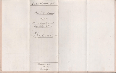 Bendigo Historical Society Inc.
Legal record - FOGGITT JONES & CO. Land sale notes, Watson, James & Rogers, Rogers Collection, 1.7.1913
... FOGGITT JONES & CO. Land sale notes....Sale notes to sell land in (Residence Areas), Wade St... Foggitt Jones and Co. Signatures. Sale notes to sell land ...In the early 1980s the firm of Watson, James & Rogers merged with the partnership of Every & Every and became the iconic “Rogers & Every” as known today. The firm is still located on Bull Street. https://rogersevery.com.au/about/Sale notes to sell land in (Residence Areas), Wade St. Golden Square to Foggitt Jones & Co. Sold all Rights to Titles and Interests. Typed on light brown paper. 1. Joseph Mitchell and Mary Ann Roberts (10317 and 10318) 2. Elizabeth Roberts (10319) 3. Alice Emily Ann Roberts (13126) 4. John Frances Roberts (10363) 5. William Davies Osborne (9805) Release by Mrs Irene Catherine Orrock for Foggitt Jones & Co. handwritten on cream coloured paper.Signatures.land sales, foggitt jones and co. -
 Ringwood and District Historical Society
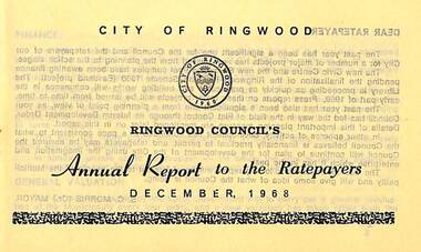
Pamphlet, Ringwood Council's Annual Report To The Ratepayers - December 1968, 1968
... , Sale of Council Land, Swimming Centre, Holiday Play Centre... Centre, Golf Course, Sale of Council Land, Swimming Centre ...City of Ringwood community information annual report for 1968, including sections covering Finance, General Valuation and Rater Payments, Property Ownership Changes, Refuse, Sanitary Serviced, Sewerage Connections to MMBW, Dandenong Valley Authority, Residential Flat Control Planning Scheme, Immunisation, Home Help, Elderly Citizens' Clubrooms, Library, Civic Centre, Golf Course, Sale of Council Land, Swimming Centre, Holiday Play Centre, Civic Week, Lake Reserve Improvements, Rubbish Dumping, Street Trees, Vandalism, White Ants, Street Construction, Fire Hazards, Dog Nuisance, House Numbering, Citizens' Advisory Service, Infant Welfare Centres, and a list of departing and current Council Representatives. Also includes general reminders regarding rat extermination, free firewood for age pensioners, overhanging vegetation, and spouses voting rights.Obituary - Mr. F.P. Dwerryhouse, Town Clerk for the past 9-1/2 years passed away on 6th December after a short illness.rinx -
 Bacchus Marsh & District Historical Society
Map, Plan of the property of Messers Atkins and Clarke to be sold at the Mansion, Bacchus Marsh 19th April 1856. Copy 1
... This plan of land allotments for sale indicates... for sale. The subdivided land shown was owned by John Atkins...This plan of land allotments for sale indicates ...This plan of land allotments for sale indicates the property once owned by the Bacchus family in and around the township area of Bacchus Marsh. The Bacchus family sold their property in Bacchus Marsh to John Atkins and Robert Nalder Clarke in March 1851. Atkins and Clarke kept the property for a number of years until April 1856 when these allotments were put up for sale.This plan is almost identical to another copy held by the Bacchus Marsh and District Historical Society, VC Record 452, BMDHS collection). This plan, VC Record 707 Copy 1, contains a little more detail overall than VC Record 452 Copy 2, such as who did the survey work for the plan (R.C. Bagot) and who the selling agents were, (W.M. Tennent), and on the right side of the plan near the Lerderderg River is indicated the general area for a second parcel of land from this sale which is to be sold. There is also a compass illustration indicating north and south compass points.This is a very early land sales plan for the township of Bacchus Marsh and it therefore provides some clues as to how the early urban development of the township took place. Upon seeing the map in 1911 Bacchus Marsh Express newspaper editor Christopher Crisp wrote "The sale appears to have created the present township, which had a nucleus in earlier times further east", Express, 30 September, 1911, page 3.A single page paper plan showing allotments of land for sale. The subdivided land shown was owned by John Atkins and Robert Nalder Clarke, but previously owned by the Bacchus Family and was in and around their Manor House (Mansion) property in Bacchus Marsh.There are 5 portions of land further divided into numerous small portions. The land for sale is bounded by the present day streets of Main Street, Young Street, McFarland Street, Morton Streets, Crook Street, and part of the eastern section extends to the Lerderderg River. Scale: 8 chains to 1 inch The plan is pasted into a bound volume containing 76 maps or plans in total. BMDHS Loc: AR/B12/S4 Bacchus Marsh Township and Nearby Districts Maps Volume In-house Digital copies: BMDHS, Computer Network: Maps\Bacchus Marsh Township and Nearby Districts Maps VolumeHeading: Plan of the first portion of land. The property of Messers Atkins and Clarke situate at Bacchus Marsh. To be sold by W.M. Tennent & Co. at the Mansion on the Ground on Saturday the 19th April 1856. Below heading: Jas Ferguson, Lithographer On upper right side: Subdivided by R.C. Bagot London and Liverpool Chambers, Melbourne. 'Thos Taubman'. Post Office Stamp: BACCHUS MARSH VICTORIA MY 6, 63bacchus marsh victoria maps, bacchus family, land sales, manor house bacchus marsh -
 Ringwood and District Historical Society
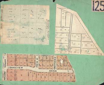
Card, Collage of Residential Subdivision Map Clippings - Ringwood, Victoria - (Undated)
... Heathmont. Clipping from a land sale brochure with street names... Heathmont. Clipping from a land sale brochure with street names ...Three maps mounted on green cardboard - Hand-drawn map of residential allotments off Warrandyte Road in Milne Road and Berringa Road Park Orchards. Map with acres roods and perches measurements of allotments in Canterbury Road and Miller Street Heathmont. Clipping from a land sale brochure with street names not existing together in the area - Rangeview Avenue, Press Avenue and Mountview Avenue. -
 Melbourne Tram Museum
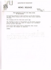
Document - Press Release, Minister of Transport, "Press Statement", Nov. 1987
... - issued 11/11/1983 - A class trams. 6. "New Rail land sale... - issued 11/11/1983 - A class trams. 6. "New Rail land sale ...Set of 11 New Releases or Press Releases with Minister of Transport letterhead. Photocopied onto A4 paper. 1. Tram services to stop for three hours on North Balwyn and Mont Albert - 18/11/1983 as a mark of respect to Naid Salem when struck by a truck at the Mont Albert terminus on 16/11. (hand written not on the sheet). 2."The Met" fare system starts today - Steve Crabb - 13/11/1983. 3. "New tram a design to meet the needs of the year 2000" - Minister visits Comeng Plant - A class trams 4. "Bonus travelcard on sale" - 10/11/1983 5. "A tram for the year 2000" - follow up - issued 11/11/1983 - A class trams. 6. "New Rail land sale on tomorrow - sale of surplus land in Doncaster - Templestowe Area" - following a decision to consider light rail rather than heavy rail. 7 "Homes now getter Transport Information Booklet" - explaining the Neighbourhood system. 8. "One Million booklets to be home delivered to explain The Met transport system" - 6/11/1983. 9. "Public Transport more cost efficient than the car" - 7/11/1983 - looks at The Met tickets pricing. 10. "Boards name for the New Transport Authorities" - 28/6/1983 - lists the names for the various authorities.Item 4 has a handwritten note in ink "NB now half a "Grand Union" at Sydney Road & Moreland Rd"trams, tramways, news broadcasts, minister for transport, mont albert, tickets, a class, doncaster, neighbourhood tickets -
 Melbourne Tram Museum
Document, Melbourne & Metropolitan Tramways Board (MMTB), "MMTB Road traffic Regulations 1958", Jan. 1958
... and safety zones. Has a McLean and Son advertisement for a land sale... and safety zones. Has a McLean and Son advertisement for a land sale ...Document produced by the MMTB for the information of Traffic Officers and Employees in Jan. 1958 - contains a reprint of the Victorian Road Traffic Regulations detailings the road rules. Extracted from the Jan. 1958 issue of Royal Auto Journal by the RACV. Section 13 details the regulations for passing stationary trams and safety zones. Has a McLean and Son advertisement for a land sale in Indented Head, Geelong region.Demonstrates a method the MMTB used to inform its staff of the road traffic regulations.Document - brown card covers side stapled with an extract from RACV Royal Auto Jan. 1958 pages 21 to 30.regulations, racv, mmtb, information, safety zones, traffic control -
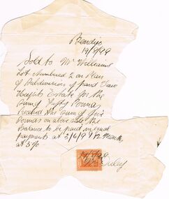 Bendigo Historical Society Inc.
Document - OWEN WILLIAMS COLLECTION: VIEW HEIGHTS ESTATE LAND SALE NOTE, 03/06/99
... OWEN WILLIAMS COLLECTION: VIEW HEIGHTS ESTATE LAND SALE...Document. The Owen Williams collection. Land Sale Note.... Document. The Owen Williams collection. Land Sale Note for View ...Document. The Owen Williams collection. Land Sale Note for View Heights Estate Bendigo. Sold to Mr Williams’s lot numbered 2 on plan of Subdivision of land View Heights Estate for the sum of fifty Pounds. Balance to be paid in equal payments at 03/06/99 and 12 months at 5%. It has a one penny orange duty stamp at the bottom with 19/08/99 and Mr Daley written on.bendigo, land sales, view heights estate, owen williams & co. -
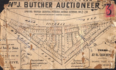 Ringwood and District Historical Society
Poster - Land Sale, Wm J. Butcher, Auctioneer - Albert Park Estate, Ringwood - c.1890
... Land Sale...Central section of land sale subdivision advertisement..., balance three years at six per cent. Central section of land sale ...Central section of land sale subdivision advertisement glued to heavy cardboard backing. Photocopied SLV image of original advertisement shows map of 117 allotments for sale in Main Lilydale Road (later Old Lilydale Road), Wandin Road (later Mount Dandenong Road), Joseph Street, Dynes Street, Albert Street (later Wyrunga Street) and Government Road (later Carcoola Road), Ringwood East.Solicitors - Jenningw & Wright, Queen Street. Surveyors - J.&H. Tarrant, Elizabeth Street. Terms £2 10s cash deposit, balance three years at six per cent. -
Glen Eira Historical Society
Document - Hengar, Glen Eira Road, 356, Elsternwick
... the land sale history since 1851 and gives a brief history... the land sale history since 1851 and gives a brief history ...A copy of two page typed report by Hilary Bullock and Rosalind Landells, dated 18/01/1990, on the history of Hengar, a dower house built for the Langdon family in 1887/1888. The report includes an explanation of the term dower house, outlines the land sale history since 1851 and gives a brief history of the occupancy of Hengar from 1888 to 1989. The file also includes one page of undated, unattributed handwritten working notes.landells rosalind, bullock hilary, hengar, glen eira road, elsternwick, holloway j m, langdon henry j, rosecraddock, beemery park estate, lirrewa, caulfield town hall, langdon family, deanmead a, griffith alfred, langdon e e, langdon h j, langdon laura, langdon henry, langdon bessie, sadler emily amy, brenton v c, herz s, beth riukan girls’ college, happy days kindergarten, florence herald herbert, happy days child minding, manners and customs, preschools