Showing 515 items
matching weatherboard building
-
 Phillip Island and District Historical Society Inc.
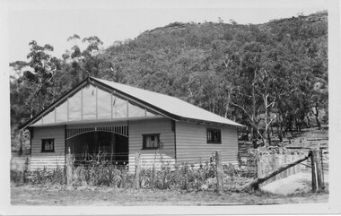
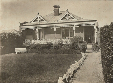
Photograph, Anderson Family & Homestead, 1887
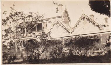
Two early Photographs of Glen Isla Home in garden setting. No specific date. Taken from 2 different angles.Two-story Weatherboard Gabled House - Glen Isla - in early years.local history, photography, photographs, slides, film, buildings, historic, the house - glen isla - in early years, phillip island, sepia photograph, mrs emma anderson jacobs -
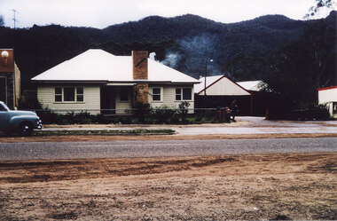
![Photograph - Digital image, House St Helena and Diamond Creek Roads [Greensborough], 02/05/2013](/media/collectors/4f729f5697f83e03086015b8/items/5729bbd22162f108e8de5be2/item-media/5729bc112162f108e8de617d/item-fit-380x285.jpg) Greensborough Historical Society
Greensborough Historical SocietyPhotograph - Digital image, House St Helena and Diamond Creek Roads [Greensborough], 02/05/2013
These photographs of the house on the corner of St Helena and Diamond Creek Roads was taken in 2013 to show changes over 40 years, based on Ron Reynold's sketches in the 1973 publication 'Greensborough and Greenhills' published by Cypress Books... which states "Built on a steep hill in a bush setting in the early 1920s, for a Dr Wood, the weatherboard house now overlooks an area of activity and change. The owners, Mr and Mrs E. 'Bluey' Blackburn, remember when their 3/4 acre building block dropped to the edge of a dirt road. Today the view from the high verandah encompasses the Main Street shopping centre, new and old bridges, new roads and houses, the Plenty River, natural bush, hills and sports grounds."Digital copy of colour photograph.greensborough and greenhills, st helena road greensborough, diamond creek road greensborough, wood family, ron reynolds -
 Greensborough Historical Society
Photograph - Digital image, Marilyn Smith, Ellis Cottage, May 2016: Outside building, 27/05/2016
In May 2016, the Nillumbik Historical Society invited Greensborough Historical Society to visit its historical centre at Ellis Cottage in Diamond Creek. Ellis Cottage was built in 1865 and is made of local uncut stone. The cottage is a typical farmers residence of this period. The stone construction is unique in this district as most construction is weatherboard. This photo shows a small outside building in the grounds of the Historical Centre.Digital colour photographellis cottage, nillumbik historical society inc. -
 City of Moorabbin Historical Society (Operating the Box Cottage Museum)
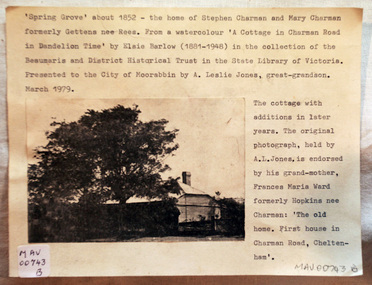
Document - Photograph, photocopy, of ‘Spring Grove’ 19th C house, Charman Road, Cheltenham, c1979
In 1852 Stephen Charman purchased 160 acres bounded by Charman Rd and Balcombe Road in an area called Spring Grove , later Cheltenham. A spring ran through the land providing a good source of water. Stephen aged 21 years had arrived in Melbourne 1842 as one of Henry Dendy’s emigrants . His Ship passage was paid by the Colonial Land and Emigration Commission and in return he was required to work on the land of the Henry Dendy Special Survey Brighton 1841. However Henry Dendy could not provide enough work for all the emigrants that arrived and Stephen had to obtain other work. Then sadly his young wife Harriett and their infant died. 1850 Stephen married widow Mary Gettens, a Publican in Little Collins Street, with 5 children. Stephen & Mary built a wattle and daub hut and established a market garden producing marigolds for Martin & Pleasance Pharmacists, Melbourne. They had 7 more children and built a weatherboard cottage that was used for early Methodist Church services. Stephen donated 1 acre to the Methodist Church in 1855 for Chapel , School and Cemetery. This is the weatherboard cottage in the photocopy showing the building extension, The road between Cheltenham and Mentone bears their name. Mary died in 1870 and Stephen remarried 1878 and died in Gippsland 1906. The original Photograph is endorsed by Francis Marie Ward , formerly Hopkins nee Charman who was the grandmother of Mr A.L Jones A photocopy of a black and white photograph of ‘Spring Grove’ , that was the first house in Charman Road , Cheltenham c1852 , showing later extensions. spring grove cottage 1852, schumer l, cheltenham, charman stephen, early settlers, jones a l, gettens mary, rees mary, charman mary, moorabbin, brighton, henry dendy special survey 1841, ward frances marie, charman frances marie -
 Halls Gap & Grampians Historical Society
Photograph - B/W, C 1875
1875-1876 The residence of John and Catherine D/Alton built on site of present Colonial Motor Inn. 1900 Owned by Langley family, "Morningside" was now taking in paying guests. 1909 Leased by James and Grace D'Alton who continued to run a small guest house. Late 1920s a small building was erected to serve as PO and telephone exchange. C1980 Guest house closed. 1982 Morningside demolished.Weatherboard house, picket fence 5 people Alexandria and Laura Sheridan, Catherine D/Alton, Meg Sheridan, a man standing at fenceMorningside 1875-76 John D'Alton and 2nd wife Catherine Fulton nee (Denholm), her mother and Aunt Mrs Sheridan original front now the back of Colonial motel Rose'e Australasian Views. Vitorian Series. Photographed and published George Rose, 123 Chapel St Windsor, Victoriabuildings, morningside, people, d'alton -
 Halls Gap & Grampians Historical Society
Postcard - B/W, C 1940s
... behind this building. The owners were John and Florence Warren ...This is the Warren Street residence of the owners of the bakery, which was situated behind this building. The owners were John and Florence Warren who ran the bakery until the 1960's when it was taken over by their daughter Ida and son-in-law Robert Greer. A weatherboard house surrounded by a 'chicken wire' fence. There is a wooded hill in the background.buildings, houses -
 Halls Gap & Grampians Historical Society
Photograph - Coloured, C 1960s
A house on the main street in Halls Gap. Photograph of a weatherboard house with an attached garage. A man and three children are standing in front of the house and a dark coloured car can be vaguely seen in the garage. To the left there is the edge of a building with a large ice-cream sign attached and to the right there is a shed set slightly back from the building and the edge of another building. There are wooded hills in the backgroundbuildings, houses -
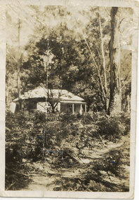 Halls Gap & Grampians Historical Society
Photograph - Sepia, C 1930s - 1940s (?)
The cottage is typical of the holiday houses that could be rented in Halls Gap. This house was called "The Wattles" and was one of the houses used as "Girls Hut".The photo shows a weatherboard cottage set in bush. A sandy path through bracken can be seen in the foreground. There is a tall gum tree in the right of the photo."The Wattles" written in pen on rear.buildings, houses -
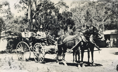 Halls Gap & Grampians Historical Society
Photograph - B/W, C 1920s ?
c 1920s ? The cottage was known as "Gray's Cottage" and was one of a number in the campground that could be rented for the holidaysPhoto mshows four men in a gig drawn by two horses. A bundle (camping gear) is stowed in front of the gig. A hurricane lamp can be seen on top of the hear in front. On the right a building can be seen, with a woman wearing an apron in the doorway. The building front (presumably the verandah) is weatherboard with the upper half being lattice. Another building (? shed) can be seen vaguely on the left. Large gums and bush are seen in the background.recreation, camping, transport, horse drawn -
 Eltham District Historical Society Inc
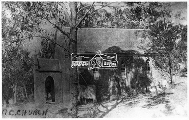
Negative - Photograph, Eltham - Old R.C. Church (building not there in 1923)
Eltham - Old R.C. Church (building not there in 1923). The original St Mary’s Roman Catholic Church (1865-1912) was built of clay brick with buttress walls and a slate roof on the corner of Fordhams Road and Maria Street (Main Road), Eltham South, opposite the present-day Wingrove Park. It was blessed on September 3, 1865. With the arrival of the railway in 1901 and the town centre moving closer to the station, the decision was made to relocate the site of the church to its present-day location on Henry Street at the corner of Main Road. A new timber weatherboard church, also called St Mary's was erected and blessed on October 13, 1912. The church and land cost £1,400 (Evelyn Observer). The original brick church It was demolished in the 1920s and the bricks and windows were recycled to build a dairy on the Brinkkotter farm at Research. The timber church was destroyed by fire in 1961 and a new modern architectural (1960s) style church was erected in its place and named Our Lady of Help Christians Church.This photo forms part of a collection of photographs gathered by the Shire of Eltham for their centenary project book,"Pioneers and Painters: 100 years of the Shire of Eltham" by Alan Marshall (1971). The collection of over 500 images is held in partnership between Eltham District Historical Society and Yarra Plenty Regional Library (Eltham Library) and is now formally known as the 'The Shire of Eltham Pioneers Photograph Collection.' It is significant in being the first community sourced collection representing the places and people of the Shire's first one hundred years.Digital image 4 x 5 inch B&W Negsepp, shire of eltham pioneers photograph collection, eltham, roman catholic church, catholic church, church, main road, st marys catholic church -
 Eltham District Historical Society Inc
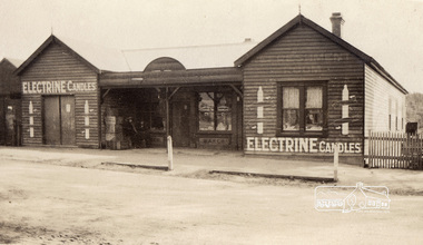
Photograph, Lloyd's Store, Main Road, Eltham, c.1916-c.1922, 1920c
Store was located opposite Dudley Street. Note various signs for Electrine Candles, Baker, Cadburys Cocoa, Cadburys Chocolate (in window) and Refreshment Room (faded). Edited version of print/digital file sourced from State Library of Victoria: Title: Lloyd's Store, Eltham, [Vic.] [picture]. Date: [ca. 1916-ca. 1922] Description: 1 photographic print : gelatin silver ; 6.6 x 10.8 cm. Copyright status: This work is out of copyright Terms of use: No copyright restrictions apply. Identifier(s): Accession no:H86.93 Subjects: Eltham (Vic.) -- Buildings, structures, etc; Victoria -- History -- 1901-1922; Gelatin silver prints Index terms: Shops; Victoria Notes: Title inscribed in ink on verso. Photographer unknown. Undated, date range provided by donor. Contents / Summary: Looking across street towards weatherboard store with porch at doorway, signs painted on front of store read: Electrine Candles. Source / Donor: Gift; Mrs. Nancy Graham; 1986.Copy of sepia photographbaker, cadburys chocolate, cadburys cocoa, lloyd's store, refreshment room, slv, shops -
 Streatham and District Historical Society
Picture, Streatham Hall
... . weatherboard buildings hall community streatham structures social ...Shows the structure and building mateials of the time. Demonstrats the need for social acivities and the need for a venue for that to happen.Demonstrates the buildings that were lost during the 1977 fires the burnt most of Streatham down.A square Black & white photo of the Streatham Hall taken from the front incluing a side angle as well. Itis a single story weatherboard structure with two doors and four windows in view.In green ink stamped on back "317"weatherboard, buildings, hall, community, streatham, structures, social, activities -
 Ringwood and District Historical Society
Photograph, Photos of last houses to face demolition at Camberwell. c1970s, c1983
One of the last houses to face demolition.Single fronted weatherboard with striped veranda blind, brick chimney over front rooms with TV aerial. Green painted walls. Red painted iron roof over veranda and under veranda rail. Adjacent to Target entrance.The 'Miss Stayput' house in the car park out the front of Target in Camberwell. You can even see the Target logo on the building. The house was owned by Mary Campigli, who defied the council order to move, and won her case in court. She stayed in the house, surrounded by a car park until she died in 1983 at the age of 94. The house was finally demolished soon after. -
 Orbost & District Historical Society
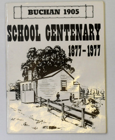
letter book, James Yeates & Sons (Printing) Pty Ltd, 1977
This book was prepared for the Buchan School centenary. In the Buchan District itinerant teaching was conducted in buildings with log walls and a bark roof typical of the mid 19th century. Not until 1878 was the first State school built on the same general site as the present school, on the Orbost Rd, ⅓ of a mile from the bridge over the Buchan River. This original school building must have been constructed from high quality timber, because it still serves as the shelter pavilion. On 11th of July 1878 William Scott opened the first school of approximately 40 pupils ranging from Grade 1 - 8. A larger weatherboard school was erected in 1914. A residence was provided for the HT in 1934 and in 1956 a second classroom erected and attached to the 1914 building. Unfortunately, all records of the Committee were lost in a fire when the homestead of Alex Cameron, then serving as Committee Secretary, was burnt to the ground, but it is well known to local citizens that Frank Moon, local prospector, explorer and discoverer of the famous Buchan Limestone Caves, attended school at SS1905 Buchan. (ref SCHOOLS EAST GIPPSLAND - John Phillips)This book is a useful research tool on the history of Buchan.Two copies of a 273 pp paper covered booklet. The cover is white with the title in black print. On the front is a sketch of an old school building. On the back is a black/white photograph of children running downhill. A book on the history of the Buchan school no.1905. Includes photographs, maps and lists of school students and staff.book buchan-history buchan-school -
 Cheese World Museum
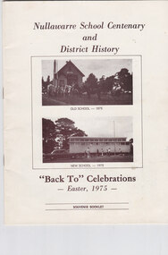
Book, Nullawarre School Centenary and District History, 1975
LeThe Uebergang family came from Silesia to Australia in 1848 and were early settlers in the Allansford area. The sons and other descendants also purchased farms in the area. The Percy Uebergang family lived at Tooram Park, Allansford from 1912 until 1992. Percy and Myrtle Uebergang's children were twins, Ray and Joyce born in 1926 who lived at Tooram Park until their deaths, Ray in 1986 and Joyce in 1992 after which the property was sold. Neither Ray nor Joyce married and following the death of her brother Joyce set up the Ray and Joyce Uebergang Foundation which supports the local community. The collection of items from their property was put into store for a number of years before being given into the care of the Cheese World Museum. The family often re-used, recycled and repaired items and examples can be seen in the museum. This item is part of the collection of items given into the care of the Cheese World Museum. Nullawarre State School No.1652 opened in 1875 on a site donated by George Henry. The weatherboard school was 27ft by 18ft. Margaret Mathieson was the first of the 17 pupils registered. The first head teacher was Charles A Bruford. The first building was replaced with a new building by 1975 when the celebrations took place. A brief history of Nullawarre township and some of its early residents is also included. Early families include Mathieson, Burleigh, LeCouteur, Wallace and Hesketh. A photograph of the Nirranda and District WWI Honor Roll details those from the Nullawarre area who served. Today the school has been enlarged and is now Nullawarre and District Primary School.This booklet is significant as it provides a history of Nullawarre school and an overview of the Nullawarre district and some of its early residents. A cream coloured booklet with sepia coloured text and photographs of the school.Nullawarre School Centenary/and/District History/OLD SCHOOL-1975/NEW SCHOOL-1975/"BackTo" Celebrations/-Easter 1975-/SOUVENIR BOOKLETallansford, nullawarre, uebergang, schools, henry, bruford, mathieson, burleigh, lecouteur, wallace, hesketh, nullawarre state school -
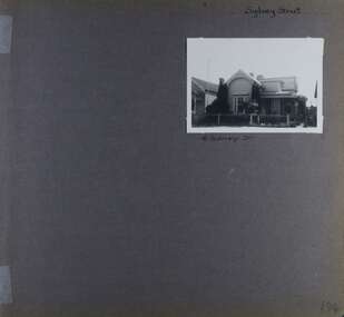 Glen Eira Historical Society
Album - Album page, Sydney Street, Circa 1972
This album was created in approximately 1972 as part of a project by the Caulfield Historical Society to assist in identifying buildings worthy of preservation. The album is related to a Survey the Caulfield Historical Society developed in collaboration with the National Trust of Australia (Victoria) and Caulfield City Council to identify historic buildings within the City of Caulfield that warranted the protection of a National Trust Classification. Principal photographer thought to be Trevor Hart, member of Caulfield Historical Society. Most photographs were taken between 1966-1972 with a small number of photographs being older and from unknown sources. All photographs are black and white except where stated, with 386 photographs over 198 pages. This house has been replaced according to Google image capture Feb 2019.Page 194 of Photograph Album with one photograph of an Edwardian house on Sydney Street, Murrumbeena.Handwritten: Sydney Street [top right] / 16 SYDNEY ST [under photo] / 194 [bottom right]trevor hart, chimneys, porch, garden, verandah, single storey, bull nose verandah, incised weatherboards, edwardian, fretwork, 1900's, return verandah, murrumbeena, sydney street, gardens -
Glen Eira Historical Society
Document - GLEN HUNTLY (HISTORY OF)
... Weatherboard Buildings Glen Huntly Railway Station Rosedale Avenue ...This file contains one item: 1/A loose-leaf, 23-page document titled ‘The History of Glen Huntly’, by Alfred R. Jones, dated 20/06/1991, describing the history of the suburb. The author has drawn heavily from the 4 sources noted in the bibliography. Subjects covered include the ship the suburb is named after, the suburb’s State School, the suburb’s churches, the Rosstown Railway and Sugar Mill, the origin of the name of Carnegie, the suburb’s aerodrome, and the beautification of the Glen Huntly Shopping Centre. The final 12 pages consist of 9 appendices relating to the aforementioned subjects. Appendix A is a typewritten letter from Ron McLeod, secretary of the Place Names Committee, to Mr. D. R. Aylen, CEO of the City of Caulfield, notifying the latter of the alteration of the name ‘Glenhuntly’ to ‘Glen Huntly’. Appendix B is a list of the ministers of St. David’s Uniting Church from its formation in 1916 to the present. Appendix C identifies the persons portrayed in St. David’s stained glass windows. Appendix D is a poster announcing the auction of 41 blocks of land between Hawthorn and Bambra Road formerly owned by William Ross, plus a map identifying said land blocks and anither fir locality. Appendix E is an A4 plan of the Rosstown Railway. Appendix F is a drawing of the Rosstown Sugar Mill. Appendix G is a poem titled ‘The Swagman’s Retreat’, by Herb Arnott, about the failure of the Mill. Appendix H is a map of Caulfield’s horse tramways plus a list of opening and closing dates. Appendix J is a list of streets explaining the meanings of their names.glen huntly, glenhuntly, local history, ‘glen huntly’ (ship), ‘glen huntlely’ (ship), quarantine stations, glen huntly road, lake street, mernda avenue, glen huntly state school no. 3703, ormond francis, ormond, garden avenue, grange road, churches, congregational church, glen huntly presbyterian church, st. david’s, st. david’s uniting church, anglican church, jenkin william ‘boss’, methodist church, wattle avenue, smith a. w. mr., glen huntly post office, glen huntly road, king f. l. mr., uniting church, child care centre, presbyterian church of eastern australia, glen huntly methodist church, sun aria, miller mary, stained glass, phrenologists, trinity congregational church, primitive methodists, ‘the victorian independent’, mercy mr., greek orthodox original old calendar church, wanalta road, salvation army, halls, myrtle street, catholic church, st. anthony’s roman catholic church, foundation stones, neerim road, mannix archbishop, st. agnes’ anglican church, booran road, sunday schools, clergy residences, ‘see’ anglican news magazine, lees archbishop, booth archbishop, glen huntly presbyterian church, el nido grove, tennis courts, bollard v. w. right rev., waratah avenue, royal avenue, munster avenue, james street, rothschild street, peace memorial organ, singers, bremner marie, scotland betty, carden joan, rosstown railway, south caulfield, plants, marata road, curraweena road, bambra road, ross william murray, ross leila, ross constance, vautin constance, ‘the grange’, north road, leila road, wild cherry road, caulfield roads board, elsternwick, land sales, sugar mills, koornang road, woornack road, elsternwick railway station, riddell parade, clarence street, dover street, oakleigh road, murrumbeena crescent, carlisle crescent, railways, trains, parks and reserves, caulfield council, sussex street, caulfield city council, swamps, rosstown sugar mill, rosstown estate, ‘the swagman’s retreat’, arnott herb, rosstown, carnegie, ‘ross’s folly’, carnegie andrew, rosstown hotel, dandenong road, rosstown road, rosstown plate horse race, caulfield racecourses, ames avenue, rosstown court, hostels, murrumbeena, cinemas, innovations (cabinetry film), films, music, pianos, manchester grove, safeway store, squash courts, airports, lord reserve, aeroplanes, air navigation act 1921, neville street, larkin sopwith aviation company of australasia, lyons street, morgan street, bookmakers, nightsoil, poultry, weatherboard buildings, glen huntly railway station, rosedale avenue, rifle clubs, scout groups, 1st glen huntly troop, ana, dowding jack mr., glen huntly infant welfare and family planning clinic, vermador private hospital, watson grove, rowlands (drapers), bones plant nursery, caulfield railway station, bridges, trams, horse tramways, glen eira road, elsternwick railway station, kooyong road, aboriginal peoples, truganini road, hannan lyn mrs. (urban planning officer), glen huntly shopping centre, sculptures, street beautification scheme, “flying the yellow flag”, moore olive, “return to rosstown”, jowett d. f., weickhardt i. s., “from sand swamp and health”, murray peter r., wells john c., caulfield historical society, newsletters, place names committee, mcleod ron, aylen d. r. mr., jones hugh rev., king joseph, scarfe james, vertigan sidney, vertigan earle, rance victor, flavell cameron, denholm robin, moorhead ken, taliai siupeli, eccles james leslie, little agnes, hutchins william r., dickie may a., gordon ivey agnes, theobald a. a. mrs., brownbill lloyd norman, ash georgette, land sales, auctions, messrs. crews & arkle, street names -
Glen Eira Historical Society
Letter - ‘MOOD KEE’
... Verandahs Weatherboard buildings Brick houses Bluestone Board ...Three items about this property, two of which were provided by Peter R Murray (author of ‘From sand, swamp and heath...’. 1/A handwritten letter to P Murray from ex resident Gwen Joynes giving some history on people and places, possibly to help with his book on Caulfield’s past. Dated 08/12/1976. 2/A handwritten letter to Mr Murray from Gwen Joynes with details about accompanying photograph of ‘Moodkee’ and people in photograph; photograph presumably returned as requested. Dated 24/03/1977 3/A photocopied photo of Mood Kee and some written research from Sand Swamp and Heath. Photo likely to be that referred to above.pennington harold, caulfield council’s meeting room, harcourt avenue, caulfield town hall, ‘rosecraddock’, caulfield, davies sydney, langdon family, ‘mood kee’, fonts, ‘yerangle’, house names, st mary’s church of england, johnstone brid. gen., subdivisions, swagmen, johnstone mrs, davis sydney, r.s.l club, ‘ripley’, slaney family, ‘sylverly’, ‘belton’, davis family, glen eira, ‘garrell’, greenwood family, ‘sanquar’, kooyong road, bell family, ‘royston’, slatter family, ‘hengar’, glen eira road, langdon family, joynes gwen, davis gwen, mosley g mrs, davies mrs, mudge mrs, slate tiles, verandahs, weatherboard buildings, brick houses, bluestone, board and shire offices -
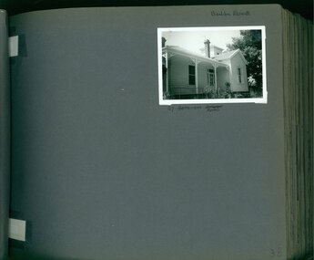 Glen Eira Historical Society
Album - Album page, Bealiba Road, Circa 1972
This photograph is part of the Caulfield Historical Album 1972. This album was created in approximately 1972 as part of a project by the Caulfield Historical Society to assist in identifying buildings worthy of preservation. The album is related to a Survey the Caulfield Historical Society developed in collaboration with the National Trust of Australia (Victoria) and Caulfield City Council to identify historic buildings within the City of Caulfield that warranted the protection of a National Trust Classification. Principal photographer thought to be Trevor Hart, member of Caulfield Historical Society. Most photographs were taken between 1966-1972 with a small number of photographs being older and from unknown sources. All photographs are black and white except where stated, with 386 photographs over 198 pages.Page 38 of Photograph Album with one landscape photograph of a timber house at 87 Bealiba Road.Handwritten: Bealiba Road [top right hand corner] / 87 Bealiba Road [underneath photograph] / 38 [bottom right]trevor hart, caulfield south, bealiba road, verandah, edwardian, woodworking, towers, chimneys, weatherboard houses -
 Federation University Historical Collection
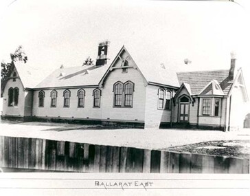
Photograph - Photograph - black and white, Ballarat East State School (No 1071)
The weatherboard Ballarat East State School SS 1071 was formerly known as Specimen Hill. According to 'Visions and Realisations' The Eureka gold lead opened in August 1852, running from Little Bendigo, south beneath Yarrowee Creek into Pennyweight flat, where it was joined 100 yards or so from the intersection of main and Eureka Streets by the Canadian Lead. State School 1071 was formerly known as Ballarat Common School No. 71, and was founded by the Free Presbyterian Church on Specimen Hill in Eureka Street, Ballarat on 01 January 1854. On 20 May 1869 the trustees of the Presbyterian School, Specimen Hill, Ballarat, consented to the transfer of the site to the Board of Education. On 01 September 1870, Specimen Hill, Ballarat, was vested in the Board and then became known as SS 1071. On 01 March 1879 the Minister, The Hon. William Collard Smith, and William Dobbie, Inspector of School Buildings, visited Ballarat to report on the buildings with a view to extensions and renovations. The minister issued instructions for the old wooden part of the school to be demolished, and brick additions to be erected, so that the whole premises would accommodate 350 students. (''Visions and Realisations: A Century of State Education in Victoria, Vol. 2'', Education Department of Victoria, 1973, p 729-730.)Black and white photograph of a weatherboard school with shingle roof known as Ballarat East (SS1071). The building has a brick chimney and bell tower. This school has Castlemaine flagging in the passages.ballarat east state school, education, st paul's school, specimen hill state school -
 Federation University Historical Collection
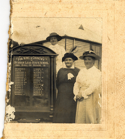
Photograph - Black and White, Durham Lead Roll of Honour, 26/10/1917
According to the Monument Australia website the 2015 location of the Honour Board was Garibaldi Hall, Hardies Hill Road, Garibaldi, Victoria. Being made in 1917, the honour board never had the end date of the war added. The Ballarat Courier wrote Ballarat Courier, 30th October 1917: At a reunion of old scholars of the Durham Lead State School on Friday 26th October 1917, an honour roll of those who had enlisted in the A.I.F. was unveiled. The honour roll contains a list of 32 names. Half of a black and white photograph showing three women standing to the right of a World War One Honour Board for Durham Lead State School. The women in the centre is thought to be Ellenor Mitchell (nee Austin). The women wear long sleeves and hats. One woman wears a white ribbon. A man's hand and shoulder is evident on the left side of the Honour Board. The building the people stand in front of looks like a weatherboard school, so it is most probably Durham Lead State School Gift of Gordon and Marilyn Vincentdurham lead state school, world war one, honour roll, durham lead state school honour roll, garibaldi hall, ellenor mitchell, ellenor austin -
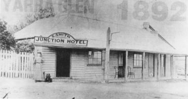 Yarra Glen & District Historical Society
Black and white photographs, Junction Hotel, Yarra Glen
The Junction Hotel was built before 1875. It was located on the corner of the Yarra Glen-Eltham and Steels Creek Roads opposite the cemetery. The building was burnt down in August 1935. Samuel Smith was the licensee from 1895 until 1905Black and white photograph of the Junction Hotel, Yarra Glen copied from newspaper. The words "YARRA GLEN 1892" appear above the building. Sign on building "S.SMITH JUNCTION HOTEL LICENSED VICTUALLER". A woman wearing an ankle-length dress and boots is standing near main entrance. Weatherboard and iron roof, picket fence. Two bentwood chairs on brick-floored verandah. A light pole is attached to the verandah post. picket fence, nineteenth century, 19th century, hotel, bentwood chair, public house, sam smith, samuel smith, weatherboard, iron roof, tin roof, woman, junction hotel -
 City of Moorabbin Historical Society (Operating the Box Cottage Museum)
Photograph - 115 Jasper Road, Bentleigh, Allan / Grewer Estate, c. 1890's
... £250.0.0 Other buildings £50.0.0 2 roomed weatherboard cottage... buildings £50.0.0 2 roomed weatherboard cottage £35.0.0 Early ...115 Jasper Road, Bentleigh East was a market garden owned by James Allan. In 1880 the property was transferred to David Grewar (Gruar) who had married James' niece Mary Allan. In 1926 part of the land was subdivided and sold as residential blocks. The block with the house pictured remained in the family until 1969. The land now forms part of Our Lady of Sacred Heart College. The description of the land owned by David Kidd Grewer (also spelt Gruar) in 1885: Fourteen acres or thereabouts at the corner of Jasper Road and Patterson’s Road East Brighton being part of Crown Block of 5720 acres Parish of Moorabbin County of Bourke being land comprised in Certificate of Title Volume 1344 Folio 268692 on which is erected a 4 roomed brick house with 2 rooms of wood at the rear and stable and a 2 roomed weatherboard cottage valued as under: 14 acres of land less crops £629.0.0 4 roomed brick house £250.0.0 Other buildings £50.0.0 2 roomed weatherboard cottage £35.0.0 Early pioneer family of the City of Moorabbin.Black and White photo in picture framegrewar, market garden, moorabbin, bentleigh, jasper road, housing, pioneer, james allan, orchard -
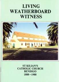 Bendigo Historical Society Inc.
Book - STRAUCH COLLECTION: LIVING WEATHERBOARD WITNESS
... Bendigo buildings historic Living Weatherboard Witness, St Kilians ...Living Weatherboard Witness, St Kilians Catholic Church Bendigo 1888-1988.book, bendigo, buildings, historic -
 Bendigo Historical Society Inc.
Document - H.A. & S.R. WILKINSON COLLECTION: CONTRACT OF SALE
Conditions of sale by private contract dated 6th July 1932 between Bendigo Mutual Permanent Land and Building Society (seller) and J. Shade (buyer) for land situate Wood Street, California Gully, at present occupied by Mrs. Dumble as tenant, containing three roods thirty-five and two-tenths perches, having a frontage of 500 links to Wood Street by a depth of 193 links being Crown allotment 1 section P described in Crown grant volume 2129 folio 425693, together with 5-roomed weatherboard dwelling and all sundry. Also ''Lux'' wood fire stove, bath and venetian blinds. Price 340 pounds.organization, business, h.a. & s.r wilkinson real estate -
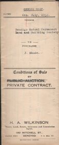
 Bendigo Historical Society Inc.
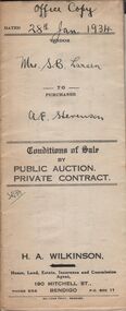
Document - H.A. & S.R. WILKINSON COLLECTION: CONTRACT OF SALE
Conditions of sale by private contract dated 28th January, 1934 between Mrs S.B. Larsen (seller) and A.E. Stevenson for land situate No.43 Breen Street, Bendigo being the land described in residence area certificate No. 32484 in the books of the mining registrar at Bendigo, together with 4-roomed weatherboard dwelling and all sundry. Also one ''Liverpool'' gas stove as inspected. Price 400 pounds. Attached a letter dated 23rd March, 1934 from the Bendigo Mutual Permanent Land and Building Society addressed to H.A. Wilkinson re: account Mrs. S. Larsen, acknowledging receipt of letter dated 22nd advising on behalf of Mrs. Larsen of sale of property at 43 Breen Street and of receipt of contract.organization, business, h.a. & s.r wilkinson real estate -
 Bendigo Historical Society Inc.
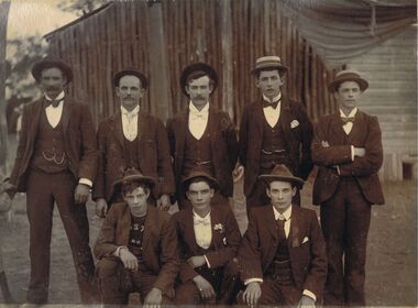
Photograph - GROUP PORTRAIT OF MALES
... of undressed log wall building, adjoining a weatherboard wall. Men..., three squatting. Men are in front of undressed log wall building ...Sepia image mounted on board: image shows group of seven men, five standing, three squatting. Men are in front of undressed log wall building, adjoining a weatherboard wall. Men are wearing three piece suits and hats, except front LH side male who has a printed jumper underneath with 'S,T and RO' visible, underneath his suit jacket. Man on LH side back is wearing a boxing glove on his right hand.person, group, males, bendigo, sandhurst, male portrait -
 Bendigo Historical Society Inc.
Photograph - HOUSE & HORSE & BUGGY
Small photograph of a weatherboard house with a tiled roof. The house has an unequal gable, a veranda at the front and part way down one side which is made into a room. It has the same roof material as the house. At the back is a large chimney just above gable height. There are some short shrubs at the side of the house and a picket fence with a girl standing in front of it. In front of the house is the horse and buggy with the family sitting in it. In the foreground is the driveway and some shrubs. Photo mounted on white card with a gold border and photographer's name faintly on the back in pink.? Baume, 5 Collins St., Melbournebuildings, house, homes, house & horse & buggy, ? baume -
 Bendigo Historical Society Inc.
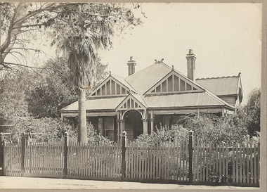
Photograph - T C WATTS & SON COLLECTION: 25 WEBSTER STREET, BENDIGO, 1929
Thomas Crouch Watts was born on March 7th. 1865, to Joseph and Susan Watts. Before the real estate business commenced, Thomas and his brother were in partnership as booksellers and stationers in a shop at View Point. Thomas lived in a fine house in Rowan Street, which was called 'Ottawa' Thomas started his real estate business in the early 1900s in a shop in View Street. His daughter Edna was the book keeper and typist, Stewart Watson was the salesman and Stanley Phipps (Edith Lunn's father) was the property manager and valuer. When Thomas Watts died in 1914, his daughter took over the running of the business. She married Stewart Watson in 1918. Eventually the name of the business was changed to Bishop and Earl. From a letter from Edith Lunn re T.C. Watts & Son. 'The firm of T.C. Watts & Son later became Bishop and Earl. When the firm of Bishop and Earl ceased to operate after the death of Edith Lunn's father, S.P. Bishop, Miss. June Parry, Secretary of the BHS was a member of staff. June rescued all the photos of properties listed for sale from the office and placed them into the custody of the BHS.' Black and white original photograph mounted on grey cardboard. Weatherboard house, corrugated iron roof. Return verandah with wooden decoration. 1 chimney. 2 decorative gables above windows. Garden with lawn, shrubs and garden seat. Written on back of image 'H. Liddall, Webster Street. Terms £500 bal 61/2 %. £775 on 30.1.41 £250 deposit, low interest to be arranged. 25 Webster Street. White sticker attached to bottom of photo board ' December 1927 Pyke Street - Bendigo £1150' 2012 photo of house attached to record.Frank A. Jeffree Photo Bendigoplace, building, residential -
 Bendigo Historical Society Inc.
Photograph - T C WATTS & SON - QUEEN STREET, 1930
BHS CollectionBlack and white photograph mounted on rectangular grey board. House, weatherboard, 3 gable rooves and small gabled portico. All gables decorated with rough cast and wooden slats. Decorative chimneys with pots, verandah posts with capitals. Tall palm tree in established garden picket fence, with ornate fence posts. Creeper over gateway. Queen Street.Frank A. Jeffree Bendigoplace, building, residential, stamped on back in rectangle ''t.c. watts and son/auctioneer/estate agents/253 mitchell street/bendigo'' stamped on back in circle ''royal historical society of victoria, bendigo branch''