Showing 9725 items
matching west
-
 Whitehorse Historical Society Inc.
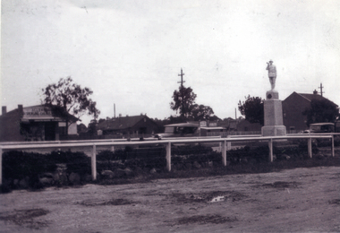
Photograph, Mitcham War Memorial
The Mitcham War Memorial is now located in Halliday Park.in Mitcham Road.Black & white photo of the Mitcham War Memorial in the centre plantation west of Mitcham Road & Whitehorse road intersection. Allan's Butcher shop is on the left and the Post Office on the right.war memorial mitcham, war memorials -
 Whitehorse Historical Society Inc.
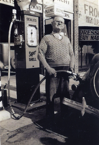
Photograph, Mitcham service station
Black and white photograph of petrol service station in Whitehorse Road Mitcham. It is thought to have been located west of Station Street. (Proprietor Mr. Kerr) Original on CDROMservice stations, whitehorse road, mitcham -
 Whitehorse Historical Society Inc.
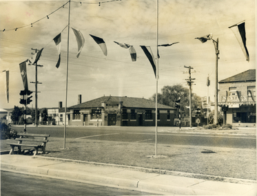
Photograph, Mitcham Hotel 1954
Originally called the Reserve Hotel; built in 1895Black and white photograph and negative of the Mitcham Hotel taken in 1954 from the north-west corner of the junction of Mitcham and Whitehorse Roads (Note early introduction of traffic lights)mitcham hotel, mitcham road, mitcham, whitehorse road, reserve hotel, byrne's -
 Mt Dandenong & District Historical Society Inc.
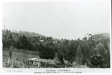
Photograph, Olinda, Victoria. Outlook to Ferntree Gully from Dulce Domun
Rose Series Postcard number 965Copy of Photo Series postcard #965 with view looking west to Mt Dandenong Road and Ridge Road. Looking across to where the Log Cabin (Kellys) would now be.mount dandenong, dulce domum, photo series -
 Bendigo Historical Society Inc.
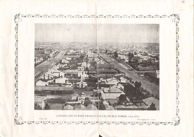
Photograph - DILLON-SHALLARD COLLECTION: PHOTOGRAPH OF BENDIGO LOOKING SOUTHWEST FROM ST.PAUL,S CHURCH TOWER
Panoramic view of Bendigo Looking South west from St. Paul's Church Tower, circa 1874. A chimney is visible in the middle of the photo. Photographer: Caire Plate 46Cairephotograph, streetscape, bendigo -
 Ballarat Tramway Museum
Slide - 35mm slide/s
Ballarat SEC single truck tram, number 31 in Victoria St. heading east, passing through King St. loop, looking south west, dated 1963.'Tram, Victoria St., Ballarat 1963'tramways, trams, victoria st., king st., tram 31 -
 Queen Victoria Women's Centre
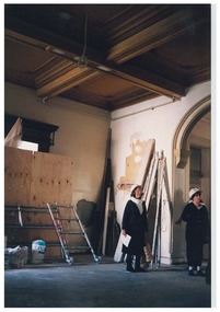
Photograph, c.1996
Colour photograph. Ground floor entrance foyer facing north west. Taken during Restoration inspection. Two unidentified women are standing facing east wearing hardhats. historic buildings, building construction, cultural structures and establishments -
 Canterbury History Group
Photograph - View from the spire of the new Canterbury Baptist Church, 1962
Black and white photograph copied by Jan Pigot from the album kept at the church, of the view of Canterbury looking to the west from the spire of the new Canterbury Baptist Church, 1962canterbury, canterbury road, canterbury baptist church, balwyn road, churches, canterbury presbyterian church, soldiers memorial hall, neighbourhood houses -
 Tarnagulla History Archive
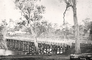
Photograph of the newly completed bridge at Newbridge, Victoria, c.1894, The newly completed bridge at Newbridge, Victoria, c.1894, 1894
Murray Comrie Collection. This photograph is a well-preserved original. Monochrome photograph depicting the newly completed wooden bridge at Newbridge, Victoria. Position of photographer is on the east bank of the Loddon, looking west toward the present day Newbridge Pub.newbridge, bridge, loddon river, infrastructure, construction, roads, businesses, buildings -
Lakes Entrance Historical Society
Book, North East Regional Tourist Authority, North East Victoria, 1980
A brief record of the region from the Murray River in the north to the Dargo High Plains in the south, from Yarrawonga and Wangaratta in the west to the Indi River in the east. Illustrated with coloured photographs.tourism, mines and mining, settlers, water supply -
Glenelg Shire Council Cultural Collection
Work on paper - Public Baths for the Borough Council of Portland
Colour plans showing the public baths of Portland. Top right is the title. Depicts the South Side Elevation, West Front Elevation and swimming area as well as several sectionsThis is the plan ***** to the Contrct / entered into this Tenth day of October 1888 / for the erection of the new Baths for the Borough of / Portland Top Right Public Baths / For the / Borough Council / of / Portland / Wm Mackay / archt Scale 16 Feet TO 1 Inchportland baths, borough of portland, william mackay -
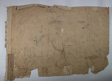 Bendigo Historical Society Inc.
Map - BENDIGO (PART), No date visible
Map:Part of Sandhurst City streets, showing west side of High St. between Ophir St. and View Place. Parish plan. Older unidentifiable map on the reverse side.map, bendigo, city streets, bendigo city streets, sandhurst city streets -
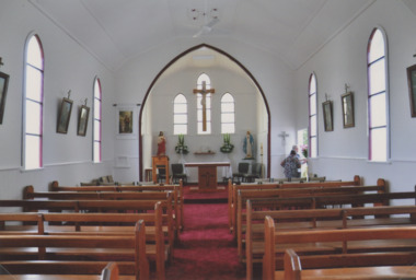 Lakes Entrance Historical Society
Photograph, Lakes Post Newspaper, St Joseph Roman Catholic Church Swan Reach Victoria
Reference E G Shire Heritage Study number 1236Colour photograph of interior of St Joseph Roman Catholic Church after refurbishment and re dedication built 1909 c on a rise on west side of Swan Reach Victoriareligion, churches -
Lakes Entrance Historical Society
Photograph - Reeves River, 1920 c
Also another black and white photograph of same view with a man in foreground 05298.1Black and white photograph showing view of Reeves River looking west towards Metung with islands Rigby and Flanagan on left and Nungurner on right Jemmys Point Lakes Entrancewaterways -
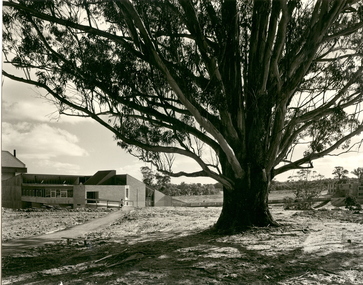 Federation University Historical Collection
Photograph - Black and White, Tree of Knowledge, Mount Helen Campus, 1973, 1973
The sod for the Mount Helen Campus was turned in 1967, and students first studied on campus in 1970. In 1973 the Union Building (Building 'U' now the Albert Coates Centre) was completedSix black and white photographs showing external views of the recently completed Union Building (Coates Centre) on the Mount Helen Campus of Federation University Australia. .1) Union Building north entrance, part of library on right, 'S' building in back. .2) Union Building north west corner, residences in background, two males. .3) Union Building north west corner, student residences in background .4) Union Building north west corner, view towards library .5) Union Building north entrance, part of library on right, 'S' building in back. Shows earthworks for the Electrical engineering building ('E' building)federation university, federation university australia, feduni, university of ballarat, ballarat college of advanced education, albert coates, albert coates centre, union building -
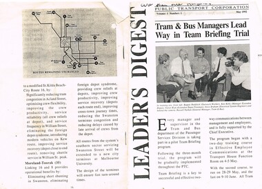 Melbourne Tram Museum
Document - Photocopy, Public Transport Corporation (PTC), "Leader's Digest", May. 1992
Photocopy of a newsletter to Public Transport Corporation staff, May 1992, titled "Leader's Digest", Vol 1 and No. 1 (unknown if any more published), with a photo of a group of five people undergoing a team briefing. Original document 16 pages, but only a few copied, principally about the proposed Tram Cross - Linking and Route Restructure proposals. Follows the Tram and Bus Strategic Review Committee of April 1991. Looks at West Coburg - Carnegie, West Preston - South Melbourne, Bundoora - East Brunswick, Mont Albert to Port Melbourne, North Balwyn - City - East Burwood, Footscray - West Maribyrnong to Glen Iris via Swan St St, Moonee Ponds - West Maribyrnong, Kew Cotham Road - William St - St Kilda and Moreland - Toorak. Has a map of the routes remaining unchanged. See Also Reg Items 344, 1545 and 2332 for related materials.trams, tramways, w class, reports, melbourne, ptc, tram depot, operations -
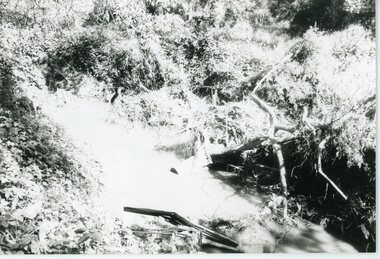 Ringwood and District Historical Society
Photograph, Mullum Mullum Creek- 29-10-89
Black and white photograph"Written on back of photograph" Mullum Mullum Creek North bank West of Harrison St Rubbish and weeds - view generally to the East -
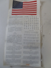 National Vietnam Veterans Museum (NVVM)
Poster, Laminated Poster, 1965
(shortened version) Poster with American flag and words. I am a citizen of the USA I not speak your language. Please take me to someone who can protect me. My government with reward you. Written in many languages underneath.Published by aeronautical chart and informationcentre US Airforce. Lithographed Dec 1965 406825 South East Asia - West central Pacificposter -
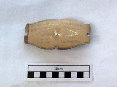 Geelong Cycling Club
Badge, 1946
The badge attaches to a silk sash to be worn by the Championship winner.Best rider for 1946 is acknowledged appropriately.Silver Sash Badge. The badge is a rectangular shape and has a pin on the back to attach it to a sash. It has inscriptions of the winner, time and the type of cycling race engraved on it. It also has a wheel with wings engraved in the background. "Geelong West Cycling Club/10 Mile Senior Championship Won by D Martin 1946 Time 26min52secs" "Wheel with Wings'sash badge; geelong west cycling club; 10 mile senior championship; d martin; 1946; -
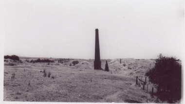 Clunes Museum
Photograph
SMALL BLACK AND WHITE PHOTOGRAPH OF MINE CHIMNEY PORT PHILIP MINEREVERSE SIDE MINE CHIMNEY JUST WEST OF SANDHEAPS FROM TALBOT ROAD LOOKING NORTH TO CHIMNEY OF PORT PHILIP MINElocal history, photography, photographs -
 National Wool Museum
Photograph
J.P. Couper, 147 West R(e)SIC.GENT St, Glasgow C2. Commercial and Technical Photographer. Phone: Douglas 5697machinery, wince machine -
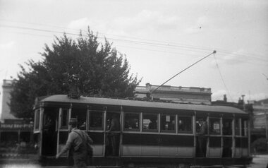 Ballarat Tramway Museum
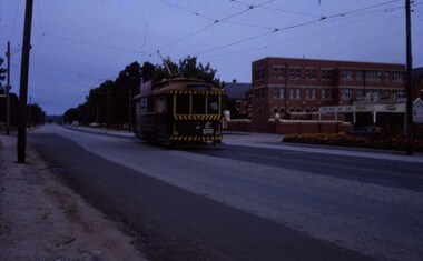
Photograph - Black & White Photograph/s, Wal Jack, Jan. 1945
Yields information about the nature of tram operations mid 1940's and number of passengers on the tram to Sturt St West.Black and white photograph of No. 29, Sturt St, Jan. 1945. Photo by Wal Jack. The tram has many passengers. Original negative scanned at hi res and image updated 1/6/2020.On rear in ink. "SEC Ballarat, No. 29 " Sturt St West", Sturt St, Ballarat Jan. 1945. (ex M&MTB)tramways, trams, sturt st, tram 29 -
Clunes Museum
Photograph - PHOTOGRAPH ALBUM
Portraits displayed in an album, collated by Mrs Ann Stevens an early pioneer of Clunes, Victoria, Australia. After the death of her husband Richard in 1884. There is no information of who the images portray.Album leather bound, gold and black embossed pattern on front, metal clasp to keep book closedOn binding; ALBUM Inside cover: Hand drawn calligraphy, "Mrs. Ann Stevens West Street Clunes June 23 1884"clunes pioneer, stevens, local history, photo album -
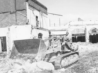 Ringwood and District Historical Society
Photograph, Maroondah Highway Central, Ringwood. Demolishing Coffee Palace and shops, corner of Maroondah Highway and Adelaide Street, 1966
Black and white photographWritten on back of photograph: "Demolishing Coffee Palace and shops on corner of Maroondah Highway and Adelaide St (west corner) Ringwood. 1966." -
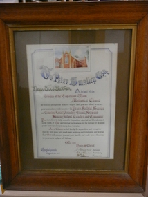 Bendigo Historical Society Inc.
Document - ILLUMINATED ADDRESS TO PETER SMALLEY ESQ, 29 August 1917
Address to Peter Smalley. Esq. Coloured print of Methodist Church. Eaglehawk West. Text reads: 'To Peter Smalley Esq. Dear Sir & Brother on behalf of the Trustees of The Eaglehawk West Methodist Church after 17 years faithful service as Trustee. Local Preacher. Circuit Steward. Sunday School Teacher and Treasurer' Signed by J.Polkinghorne - Minister. Robert Murdoch - Secretary. D.Wetistu - Treasurer. Dated 29 August, 1917.document, certificate, personal -
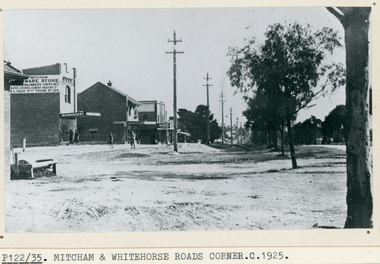 Whitehorse Historical Society Inc.
Photograph, Whitehorse Road, Mitcham, C1925
Black and white photo of Whitehorse Road, Mitcham looking west -1925. Note the Mitcham Hardware Store (Ironmongery), the Post Office and Drake & Co. Section shown is further west than actual corner. Monty Gray's ironmongery was approximately half way down the block between Mitcham Road and Station Street. Horse trough later moved to front of Reserve Hotel. Drake and Co. shown on one of their several locations.whitehorse road, mitcham, mitcham post office, drake & co, mitcham hardware store, ironmongery -
 Ballarat Tramway Museum
Slide - 35mm slide/s, Keith Caldwell, 1963
Yields information about tram 35 and the Parker St loop in Sturt St.Agfa colour slides, white cardboard mount, photo by Keith Caldwell during 1963 of: Tram 35 in Sturt St West crossing number 33 at the Parker St loop with Ballarat College in the background. Tram 35 has the destination of Sturt St West and has a SEC Electric cooking roof advert and No. 30, Mt Pleasant. See Reg Item 7353 for the 35 waiting to cross with number 30.tramways, trams, sturt st west, parker st loop, tram 35, tram 30 -
 Ballarat Tramway Museum
Document - Photocopy, Davis Urban Bus Service - timetables, 1971
Photocopies of the Davis Urban Bus Services to replace the tram services in Ballarat in 1971. Sebastopol - City - Lydiard St. North (routes 4 and 12) Sturt St West - City - Mt. Pleasant (routes 11 and 15) Wendouree West - City - Victoria St (routes 1 and 7) Timetables for Monday to Friday, Saturday and Sunday. Foolscap and quarto sheets photocopied with newspaper extracts in the background. Made on heat sensitive paper.trams, tramways, buses, timetables, ballarat, davis bus lines -
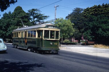 Ballarat Tramway Museum
Slide - 35mm slide/s, Ben Parle, Jan. 1954
Kodachrome Transparency - 35mm slide - cardboard mount, with one side with red border and words "Kodachrome Transparency" top and bottom. On the other side is "Made in England" and "View from this side". Photo taken by Ben Parle 1/1954. Photo of Ballarat No. 40, Sturt St. West, with St Patricks school in the background. Tram has the destination of Gardens via Sturt St West. For high resolution scan see btm2815h.tif "Sturt St Ballarat" "1/54"tramways, trams, sturt st west, tram 40 -
 City of Moorabbin Historical Society (Operating the Box Cottage Museum)
Photograph - Map of Dendy's Special Survey, 1852 Map of Henry Dendy's Special Survey of 1841, 19th Century
A Map drawn in 1852 that shows the 5,120 acres that formed Dendy's Special Survey of 1841. In 1840 Henry Dendy, a farmer in Surrey, England acquired a "Special Survey" from the Commissioners for Land and Emigration which gave Dendy the right to choose land in Port Phillip for the "bargain basement" price of only £1 per acre for 5120 acres, (an area of 8 square miles). The Special Survey also included the right to "the shipment of a worker for every £20 spent on land, whose free passage was paid by the Crown, equalling a total of 100 workers ". Accordingly Dendy sold his English holdings and paid the required £5120 and arrived in Melbourne in February 1841. However by this time land in the new colony was selling for £5 - £40 per acre. Because Henry Dendy possessed the order from the Colonial Office in London he was able to successfully oppose Governor LaTrobe's attempts to alter the price of the land. Dendy appointed Jonathan Were, (an entrepreneur, who had arrived in 1839), as his Manager and who later became a partner. Together, Dendy and Were decided on an area 5 miles south from Melbourne, bounded by North Road, East Boundary Road, South Road and to the west by Port Phillip Bay. Were and Dendy pitched their tents in the area now known as ' Park St, Brighton' and sank a well near the corner of 'St Andrew's St and Wells St'. By 1845 J.B Were and Company had bought almost half of Dendy's land and Were built himself "Moorabbin House" in Were St Brighton made from stone, quarried from local cliffs. It was still standing in 1924. Legend records Moorabbin is named after the Aboriginal word for ' Mother's Milk ' The soil is very fertile and well supplied with water especially in the area called 'East Brighton' - now known as Bentleigh and East Bentleigh - By 1850 the area had developed with numerous market gardens, dairy farms, fruit gardens and vineyards supplying food for the growing population of Melbourne.This Map shows the birth of the Brighton and Moorabbin area. On 18th January1859 Brighton was proclaimed a Municipality and a Borough by October 1863. Meanwhile, following a Petition, the area of East and South Brighton, incorporating Mordialloc, Cheltenham, Mentone, Sandringham and Oakleigh separated from Brighton to form the Moorabbin District Roads Board becoming the first Local Government Authority. Col. William Mair was elected as the first Chairman of the Moorabbin Roads Board. Moorabbin Shire 1871 developed further and was declared a City in1934. The City of Moorabbin was the largest Municipality in Melbourne before the Amalgamation of Councils in 1994 when it was divided in the south to City of Kingston and in the north to City of Glen Eira A Photo-lithographed 1852 Map showing the 5,120 acres that formed Dendy's Special Survey of 1841. Henry Dendy & Jonathan Were chose an area 5 miles south from Melbourne, bounded by North Road, East Boundary Road, South Road and to the west by Port Phillip Bay. Moorabbin County of Bourke / Photo-Lithographed at the department of Lands and Survey. /Melbourne. / Price 1/- brighton, moorabbin, bentleigh, cheltenham, dendy henry, bent thomas, were jonathan, special survey