Showing 6702 items
matching river
-
 University of Melbourne, Burnley Campus Archives
Plan - Photocopy, Horticultural Society of Victoria's Experimental Gardens, 1888, 1888
Photocopy of Plan of Richmond stretching N past Barkers Rd., W to Stawell St. E past Power St and S below Richmond Park - takes in loop in river around the Horticultural Society's Garden and Richmond Park. This plan was used in the Burnley College Centenary display. richmond, parks, centenary, experimental gardens, hoticultural society of victoria -
Bendigo Historical Society Inc.
Document - The Reynolds Family Records Collection (Folder 2 of 4) Richard David Hinde, Abt 2005
Eleanor Hinde (1842-1902) was born in Lancashire England. In 1858, Eleanor married Richard Reynold in the Forest St Wesleyn Methodist Church in Sandhurst. They both gave their address as Sailors Gully Goldfields. They had seven children together. Richard was a skilled tradesman and after he died in 1872 from lung disease, Eleanor married Arculus Opie. Eleanor owned a property on the corner of Gladstone and Stanley Streets which later became an electrical substation. She sold poultry and eggs and preserves. One of Eleanor's sons, William John, married Anna (Annie) Jorgensen, and one of her daughters. Amelia, married Anna's brother Thomas Joynes Jorgensen. The Jorgensens founded and managed Jorgensen and Sons foundry and engineering works. Peter Jorgensen (1849-1914), was a mining contractor, he lived at, "Bro," Russell street, Quarry Hill. His firm was Jorgensen and Sons, mining contractors. He was a native of the Island of Alsen, Denmark. He left Denmark in the year 1861, embarking at Hamburg in a small sailing Ship. The four folders contain family history documents and photos of the descendants of Eleanor Hinde. Notes on Notes on Richard David Hinde and Sarah Cole who had an orchard on the Campaspe River (possibly Bagshot); which he willed to his sister Eleanor. Richard died about 1925.bendigo, sandhurst, peter jorgensen, eleanor hinde, eleanor reynolds, eleanor opie, reynolds collection, richard david hinde -
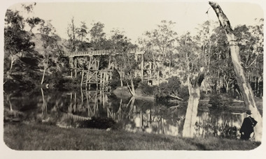
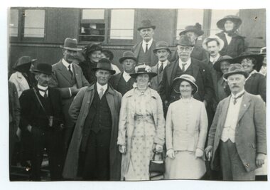 Orbost & District Historical Society
black and white photograph, 1916
About 1912 work began at Newmerella on clearing the track for the railway line from Bairnsdale to Orbost. A canvas town sprang up on the higher land adjacent to the river flats. Local farmers supplied meat, milk and fresh produce to the camp, as well as gaining employment carting and labouring. The line opened in 1916, the Orbost railway station being built on the Newmerella side of the river. This item is associated with the history of the Orbost-Bairnsdale railway line and therefore reflects the role that the rail line played in the social and economic history of Orbost. On April 10 1916, the first scheduled train service left Orbost for Bairnsdale. The Bairnsdale-Orbost railway was opened to serve the agricultural and timber industry. Because of the decline in traffic and heavy operating costs, the line was finally closed in August, 1987.A black / white photograph of a group of people standing next to a train carriage.orbost-railway east-gippsland-railway celebration-opening-of railway -
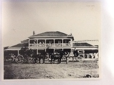 Port of Echuca
Photograph, Approx. 1970's
The Bridge Hotel was built by Henry Hopwood to house visitors to the town crossing the Murray River on his punt , which was situated just below the Bridge Hotel on the Murray River. The accommodation was spacious and grand! In the right back corner of the photograph, the 'lantern' roof of the St George's Hall can be seen. The street is level with the front entrance to the Hotel, which is very different to what it is today.The photograph shows hotel activities and accommodation in the late 19th Century. The Bridge Hotel was a very busy place as can be seen with women on the balcony, a stage coach full of people, laden carts and buggies.The Bridge Hotel Echuca - photo taken looking south towards front of building. Four people can be seen on the balcony and several gathered under the verandah. In the foreground are several horse-drawn carriages. The road in front of the hotel is unmade and very wide, with the roof of St.George's Hall seen over the right (western) wing of the hotel. Verso: Bridge Hotel, 1860s? St. George's Hall in background.bridge hotel, henry hopwood, lantern roof, st.george's hall, 1870s -
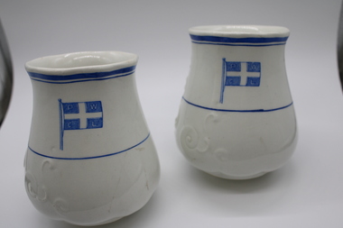 Port of Echuca
Decorative object - Permewan Wright Vase
Permewan Wright & Co Ltd were one of the biggest shipping agents on the Murray in the 2nd half of the 19th century. They were a cartage company established in 1856 in Geelong, who opened one of its twenty Victorian branches at Echuca in 1875. The company dominated the river trade in Echuca during the 1880s and 1890s, operating a fleet of steamers on the Murray, Murrumbidgee and Edwards Rivers.Off White Vase with blue decorative Permewan Wright Co Flag. Thin blue lines encircled at top and middle. Slightly scalloped opening.Decorative Scrolls embossed on one side. permewan wright, river transport, permewan wright building, permewan wright flag -
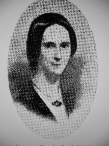 Greensborough Historical Society
Photograph - Digital image, Mrs Edward Green, 1850c
Portrait of Mrs Edward Green. In the 1840s, Edward B. Green ran the mail service between Melbourne and Sydney and owned a parcel of land on the Plenty River. He engaged a surveyor to draw up plans and lay out a township on the slopes overlooking the river, and to mark out small farm holdings on the flats. This small township named after him is now Greensborough.Digital copy of portraitedward bernard green -
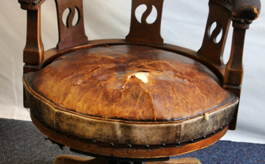 Orbost & District Historical Society
chair
Editor's chair. Used by Mr Billy Ross, proprietor of "Snowy River Mail". Donated by Mr George Hollins, later proprietor of "Snowy River Mail". William Ross (1868-1957) was editor of S.R.M. for many years. He was also a talented musician, Presbyterian church organist. Married Jessie Gray. Brought up Jean,Les, Dave, Keith Gray.Since 1890 the Snowy River Mail has been the local newspaper of the Orbost district.This local paper has been the means by which readers in Orbost were able to learn about newsworthy events and issues in their local community for over a centuryLarge round carved wood and leather arm chair on metal swivel. Wooden leg supports. Padded seat - probably horsehair. Spring suspension.On back of head rest - cut out 3.chair chair-wooden billy-ross snowy-river-mail -
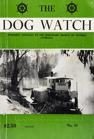 Mission to Seafarers Victoria
Journal (item) - Periodicals-Annual, Shiplovers' Society of Victoria, The Annual Dog Watch
This journal provides the reader with glimpses of the adventures and hardships of a seaman's life. Many of the stories are of sailing ships. PS Etona was built in 1898 at Milang, South Australia as a missionary church steamer for the Church of England. The Etona's run was from Mannum, South Australia, where she was based up to Renmark. As churches were built in river tower she was no longer required and in 1912 she was sold to Captain Arch Conner who used her as a fishing steamer at Boundary Bend for many years. She was brought out of retirement during the 1956 floods to do trips up the Murrumbidgee River. She was eventually bought by interest in Echuca and restoration was commenced in 1962. The Etona, now fully restored with her original steam engine can now be seen moored along side the historic wharf at Echuca.Contributes to our knowledge of the importance of shipping and places on record those stories of the sea which would otherwise be lost.Contents Foreword - G. F. Tilley - 5 The "Etona" - H. Vaughan Evans - 6 Editorial - Russell Hemingway - 11 The Old Lady Of The River - Captain J. Gaby - 19 "Takapuna" Interlude On A Moonless Night - E. Harper - 31 Maritime Museum of Tasmania - J. Miller - 34 The Confederate Raiders "Florida" and "Alabama" - A. R. Osmond - 36 "Ease After War . . . Doth Greatly Please" - Captain W. J. Cowling - 44 Mutiny At Sea - P. R. Wilkins - 49 War Service In The Indian Ocean - H. Mossman - 51 Cape Horn - Captain Eino Koivistoinen - 57 "Tragedy of Loss" - Jonathan john - 61 The End of The "Queen Elizabeth" - Bradley J. Newell - 62 London Could Cope With Him - Dr. Stanislaw Bernatt - 68 Three Ships Canals - N. S. Smith - 69 The Loss Of The "Eyoshi Maru" - Captain M. B. Glasier - 77 A Small Consignment But Valuable - J. B. Hodgson - 85 Lowden and The "Candida" - D. R. Rickard - 87 "Lauriston" Sails On - F. W. Rudd - 89 Confusion of Identities, "Young Australian", "Young Australia" and "Carl" - J. M. MacKenzie - 93 Rescue from "Clarissa", 1957 - Captain Leif Asklund - 97 Journey Home - Captain W. E. Eastoe - 100 Disaster At Blanket Bay - J. K. Loney - 104 The End Of The "Antiope" - Captain Bruce Bell - 106 The "Great Britain" - C. E. Bonwick - 108 Search The Coast To Shark Bay - Rear-Admiral Charles Adair U.S.N. - 110 The "Polly Woodside" Family - Rev. H. W. Coffey - 121 Book Reviews - 123sailing ships, steamships, shipping, seafaring life, shiplovers' society of victoria, dog watch, murray river, paddlesteamers, echuca, etona, ps etona -
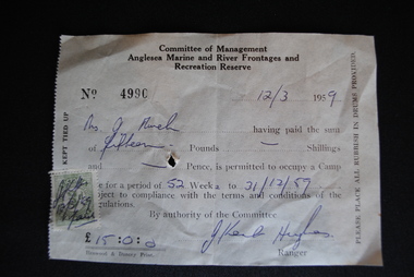 Anglesea and District Historical Society
Permit
Stamped - initialled receipt being for camping fees for 52 weeks to 31/12/1959. 15 pounds received from Mrs. J. Murch on 12/3/1959.Committee of Management / Anglesea Marine and River Frontages and / Recreation Reserve / No 4990 - 12/3/1959 - Mrs J.Murch. 15 pounds to occupy a camp to 31/12/1959. Signed J. Ken Hughes / Ranger.anglesea marine & river frontages & recreation reserves, j. murch, camping -
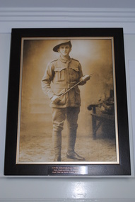 Anglesea and District Historical Society
Portrait Photograph, Original photo 1916. Reproduction 2011
Framed reproduction of sepia photograph of Pte. Alfred John Evans in full WW1 Australian Army uniform printed on canvas - timber frame has gold-toned insert.Metal Plaque attached reads "3139 Pte. Alfred John Evans, 58th Bn. A.I.F / Born, Anglesea River, 20 January 1893 / Died, Ville-sur-Ancre, France, 4 July, 1918".ww1, evans, military -
 Eltham District Historical Society Inc
Photograph, Sketch of man on bridge over creek, 1971
Sketch of a man with a fishing pole standing on a bridge over a creek, stream or river in a bush setting. Unidentified artist and location.This photo forms part of a collection of photographs gathered by the Shire of Eltham for their centenary project book, "Pioneers and Painters: 100 years of the Shire of Eltham" by Alan Marshall (1971). The collection of over 500 images is held in partnership between Eltham District Historical Society and Yarra Plenty Regional Library (Eltham Library) and is now formally known as 'The Shire of Eltham Pioneers Photograph Collection.' It is significant in being the first community sourced collection representing the places and people of the Shire's first one hundred years.Digital imagesepp, shire of eltham pioneers photograph collection, fishing, creek, sketch, tranquil, unidentified, other areas, bush, outdoors, country life -
 Greensborough Historical Society
Slide - Photograph, John Ramsdale, Pioneer Reserve plaque: Slide 26, 1990s
Photograph shows the Pioneer Reserve Park Plaque explaining that the bluestones came from the bridge over the Plenty River at Greensborough.Part of the John Ramsdale collection of slides and audio visual material.Colour photograph scanned from slide.No maker's marks. No caption on slide.plenty river, pioneer reserve greensborough, bluestone bridge greensborough -
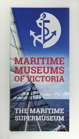 Mission to Seafarers Victoria
Booklet - Leaflet, Maritime Museums of Victoria, Maritime Museums of Victoria - The Maritime Supermuseum, 2017
Maritime Museums of Victoria is a network of sixteen museum sites in the State of Victoria along the Coast but also along the Murray River.The network was created in 2007. The Mission joined the network in July 2013 and the Mission hosts meetings on occasions.Three-fold A4 brochure on glossy colour papermaritime museums of victoria, network, victoria, mmv, interest group, membership -
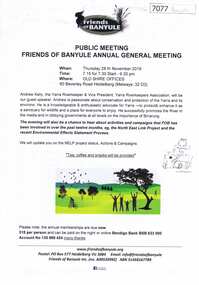 Greensborough Historical Society
Document, Friends of Banyule Annual General Meeting 2019, 28/11/2019
Friends of Banyule has been involved in campaigns relating to the North East Link, the environment and the River Yarra (Speaker for this Meeting)1 p. text, col. & black and white illus., with 2 leaflets on NorthEast Link distributed at the meetingyarra river, north east link, friends of banyule -
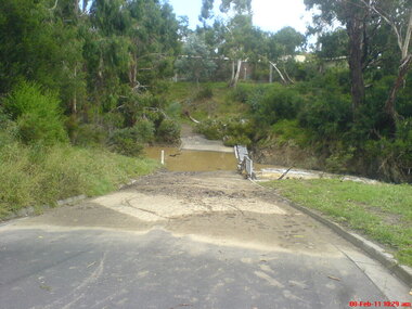 Greensborough Historical Society
Photograph - Digital image, Jasmin Burge, Kalparrin in flood February 2011: group of 5 photographs, 08/02/2011
In February 2011, the Plenty River flooded the Kalparrin area in Greensborough. These photographs were taken by GHS member Jasmin Burge.Digital copy of colour photographs.kalparrin reserve, plenty river, floods -
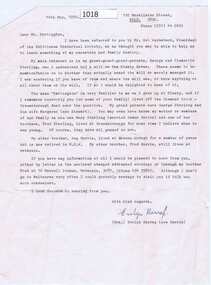 Greensborough Historical Society
Letter, Evelyn Harrap, Harrap to Partington 1990, 14/05/1990
Request from Mrs Harrap to Alan Partington for information on the Starling family [who had a small mill on the Plenty River].Typed letter, one page.starling family, alan partington, evelyn harrap (nee harris) -
Malmsbury Historical Society
Photograph (Item), B/W R. Castle & B. Slimmon Near Viaduct, Malmsbury ca1991
People - "Castle, R; Slimmon, B; Manktelow, D" Buildings - "Coliban River,Viaduct" Associated with - Heritage Week (1991) -
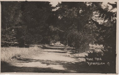 Rutherglen Historical Society
Image, Park Path Rutherglen 17, c1890
Path shown is on the western side of Lake King, Rutherglen. The pine trees have been replaced with river red gums.Black and white postcard photograph showing a path through and avenue of trees.Printed at bottom right of photo: "Park Path Rutherglen 17" Message written on back of card: "Dear Alban | Just a card to wish you the complements of the season. I've been so busy that I've not had time to write, so excuse this short note. Hoping you and yours are in the best of health as we are also. I am your affectionate cousin Olga"rutherglen park, lake king -
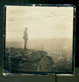 Magnet Galleries Melbourne Inc
Seymour Army Camp, les chandler_a00137.tif
A contemplative Les Chandler on a peak overlooking the Seymour Army Camp, 1915. The Goulburn River can be seen to the right of frame. seymour army camp, australia, soldier, goulburn river, 1915, ww1, world war 1 -
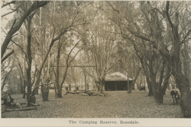 Lakes Entrance Historical Society
Postcard, Camping Reserve Rosedale, 1940 c
Also a black and white postcard of highway bridge over the Latrobe River Rosedale 05412.1 9 x 14 cmBlack and white postcard of camping reserve showing picnic shelter and two fire places set in timbered area and glimpses of highway bridge through trees Rosedale VictoriaThe Camping Reserve Rosedalecamping, bridges -
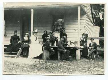 Orbost & District Historical Society
black and white photograph, Green, O. S, April 1897
This photograph shows the Richardson family having a picnic on the verandah of Captain McNeil' house at Marlo - April 1897. Snowy River Shipping Company formed in 1880. They were soon shipping produce (mainly vegetables) from the area to Melbourne. The Snowy River Shipping Company was formed by Mr Henry James during the 1880s, with Captain McNeil as master. Captain Hegarty was the shipping agent at Marlo. Towing a line of small barges these paddle steamers plied their trade between the port of Marlo, and the farms along the river banks, churning their way almost twenty miles upstream to a landing beside what is now Frank Richardson’s property. On these trips, the barges carried mail and supplies to the townspeople and farmers, loading their produce, mostly maize, on the return trip to the coast. The coming of the railway in 1915 spelt the end for the little river boats. ( ref. F. W. RODWELL in the “Snowy Review”) Frank Richardson 1877-1950 was a sawmiller at Tabbara and helped build and run paddle steamer "Curlip"as engineer. Captain McNeil was an always cheerful Marlo identity and local children had many times sailing with him on the river. Captain McNeil with tug went out through the entrance and brought in the schooners.This item is associated with the Richardson family, early settlers of the Orbost district.A black / white photograph of a group of people having afternoon tea on the end of a verandah of a wooden house. All are seated.on back - " The Richardson family picnic at Marlo"richardson-family-orbost-marlo mcneil-captain -
 Kew Historical Society Inc
Photograph - Demolishing the Zig-Zag Bridge, 1929
Henry Beater Christian (1886-1962) , was a descendant of one of the earliest settler families in Kew. Employed at the Kew Asylum as a 'public servant', he was a skilled amateur photographer, photographing numerous scenes in Kew and on his travels around Victoria. The majority of his photographs date from 1916 to 1929. His finest photographs are housed in two photograph albums. Rare photograph of the demolition of the Zig-Zag Bridge linking the two asylums on either side of the Yarra River.Digital copy of a photograph from page 16 of the 47-page photograph album containing 261 gelatinous silver images, loaned by Diane Washfold with permission given to digitise and hold a copy in our collection. The Zig-Zag Bridge linked the grounds of the Yarra Bend and Kew Asylums. The wooden bridge was constructed in the 1870s and lasted through numerous floods until its destruction in 1929. A horizontal structure, the walkway was reached via a wooden staircase on the Kew bank of the river. The steps were required due to the different levels of the banks on this stretch of the river. This is a photo of the bridge before part of it was destroyed in a flood in 1929. A man, perhaps Henry Christian, stands at the right of the foreground."Demolishing Zig-Zag / 6. 1929"henry beater christian (1886-1962), landscape photography, kew (vic.) — yarra river, christian-washfold collection, photograph albums, zig-zag bridge -
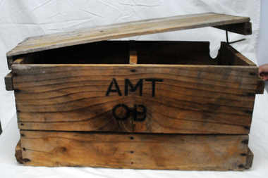 Orbost & District Historical Society
box, first half 20th century
This box was used by Lindsay Thomson's mother, Annie M. Thomson for the transport of hen eggs from Orbost to Melbourne by rail - C 1940's -1950's. The Bairnsdale-Orbost railway was opened in 1916 to serve the agricultural and timber industry. Because of the decline in traffic and heavy operating costs, the line was finally closed in August, 1987. Orbost Railway Station was opened on Monday 10 April 1916 as the terminus of the Orbost railway line, and closed in 1987. The station was located on the west side of the Snowy River despite the town of Orbost being on the east side of the river, in order to save on the costs of a bridge over the river, which at the time had highly variable levels. This item is associated with the history of the Orbost-Bairnsdale railway line and therefore reflects the role that the rail line played in the social and economic history of Orbost. A wooden box with two inside sections and a wooden lid which is secured on both ends by large nails/spikes which are fitted into a groove and are then turned. On front and back in black stencilled letters A M T O B container railway eggs -
 Kew Historical Society Inc
Photograph - Kew Main Drain, 1984
'Kew, Kew East, Balwyn & Balwyn North are located approximately 7km north east of Melbourne. Four main stormwater drains service the area flowing from south to north. Three of the drains: Deepdene Drain; Balwyn Drain & Glass Creek converge in Kew East just west of Burke Road at Kew High School before discharging into the Yarra River. The fourth drain, Kew Main Drain connects directly with the Yarra River to the West of Glass Creek.' The Kew Main Drain is a barrel drain that was created in the 1930s, and follows the route of the former Connor's Creek from the vicinity of Genazzano FCJ College to the Yarra River in East KewImportant and verifiable evidence of the construction methods used by the Melbourne & Metropolitan Board of Works in building the Kew Main Drain, before its reconstruction in c.1985.Original print colour positive photograph of the Kew Main Drain, provided on 14/12.84 to the Chief Engineer of the City of Kew, Ian Poulter, by the Supervising Engineer (Works), Southern and Eastern Drainage, Melbourne & Metropolitan Board of Works. The record includes an image of the reverse as well as the donation document from the MMBW."A84/1855-9 / 750mm council drain looking D/S [down stream] and across Parkhill Road. To be replaced with 1200 mm R.C.P. [reinforced concrete pipe] as part of MMBW Kew Main Drain reconstruction works"kew main drain, stormwater drains -- kew (vic.), connor's creek -- kew (vic.) -
 Kew Historical Society Inc
Photograph - Kew Main Drain, 1984
'Kew, Kew East, Balwyn & Balwyn North are located approximately 7km north east of Melbourne. Four main stormwater drains service the area flowing from south to north. Three of the drains: Deepdene Drain; Balwyn Drain & Glass Creek converge in Kew East just west of Burke Road at Kew High School before discharging into the Yarra River. The fourth drain, Kew Main Drain connects directly with the Yarra River to the West of Glass Creek.' The Kew Main Drain is a barrel drain that was created in the 1930s, and follows the route of the former Connor's Creek from the vicinity of Genazzano FCJ College to the Yarra River in East KewImportant and verifiable evidence of the construction methods used by the Melbourne & Metropolitan Board of Works in building the Kew Main Drain, before its reconstruction in c.1985.Original print colour positive photograph of the Kew Main Drain, provided on 14/12.84 to the Chief Engineer of the City of Kew, Ian Poulter, by the Supervising Engineer (Works), Southern and Eastern Drainage, Melbourne & Metropolitan Board of Works. The record includes an image of the reverse as well as the donation document from the MMBW."A84/1855-10 / 750mm council drain looking U/S [up stream] from Parkhill Road, Kew."kew main drain, stormwater drains -- kew (vic.), connor's creek -- kew (vic.) -
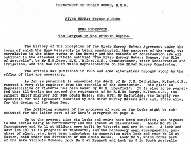 Wodonga & District Historical Society Inc
Album - Hume Reservoir Australia Album - Introduction - Part 1, Department of Public Works, N.S.W, 1927
This set of photos is from a leather bound album bearing the inscription "HUME RESERVOIR AUSTRALIA" plus 'The Rt. Hon. L. C. M. S. Amery, P. C., M .P.' all inscribed in gold. It was presented to The Rt. Hon. L. C. M. S. Amery, P. C., M. P, Secretary of State for Dominion Affairs on the occasion of his visit to the Hume Reservoir on 2nd November 1927. This album is of local and national significance as it documents the planning and development of the Hume Reservoir up to 1927. It was the largest water reservoir in the British Empire. The album records the pioneering engineering work that went into its construction.RIVER MURRAY WATERS SCHEME, HUME RESERVOIR THE LARGEST IN THE BRITISH EMPIRE. ' The history of the inception of the River Murray Waters Agreement under the terms of which the Hume Reservoir is being constructed, the purposes of the work, its correlation to the other works on the Murray and the methods of construction are all outlined in the attached article entitled “The River Murray Waters Scheme, the Nile of Australia”, by Mr H.H. Dare, M.E., M.Inst.C.E., Commissioner, Water Conservation and Irrigation, and the New South Wales Representative on the River Murray Commission. The article was published in 1925 and some alterations brought about by the efflux of time are necessary. As far as personnel is concerned, the death of Mr J.S. Dethridge, M.Inst.C.E., removed a very able engineer from the councils of the Commission. His place as Representative of Victoria has been taken by Mr R. Horsfield. It is also to be regretted that ill-health has caused the retirement of Mr E.M. de Burgh, M.Inst.C.E., the eminent Chief Engineer for New South Wales, who, with Mr Dethridge, was largely responsible for the Agreement cemented by the River Murray Waters Acts and, inter alia, for the design of the Hume Dam. The following summary of the progress of work on the Locks might be substituted for the latter part of Mr Dare’s paragraph. Up to the present time six locks and weirs have been completed, the highest in the series being at Torrumberry and the lowest at Blanchetown. Locks No.26 at Torrumberry and No.11 at Mildura were built by Victoria and are in use. A lock and weir (No.10) is in progress at Wentworth, and the necessary camp arrangements, purchase of plant, etc., have been undertaken in connection with lock and weir No.15 at Euston, both under the direction of New South Wales. Lock No.9, which forms part of the Lake Victoria Scheme, Lock No.5 at Renmark and Lock No.3 in South Australia hume reservoir australia, river murray waters scheme -
 Port of Echuca
A black and white photograph, The Bridge Hotel, in 1896, showing Silky Oak trees, 1970's
The Bridge Hotel was built by Henry Hopwood to house visitors to the town crossing the Murray River on his punt crossing, which was situated just below the Bridge Hotel on the Murray River. The accommodation was spacious and grand! In the right back corner of the photograph, the 'lantern' roof of the St Georges Hall can be seen. The street is level with the front entrance to the Hotel, which is very different to what it is today.The photograph shows hotel activities and accommodation in the late 19th Century.A black and white photograph of the Bridge Hotel taken from the Hopwood Gardens. The photograph shows four silky oak trees growing along the front of the building. There is an empty flag pole outside the front of the building. The right wing advertises billiards, whilst the left wing apparently was a bar.Written on the building can be seen the words; HOTEL and BILLIARDS. Written in pen on the back of the photograph are the words "Bridge Hotel. Probably 1896, showing Silky Oak trees.bridge hotel, henry hopwood, silky oak trees, lantern roof, st georges hotel -
 Greensborough Historical Society
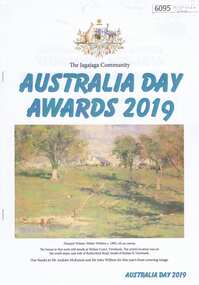
Booklet, Jenny Macklin, The Jagajaga Community Australia Day Awards 2019, 26/01/2019
This booklet lists the recipients of the Jagajaga Community Australia Day Awards 2019, hosted by Jenny Macklin, Federal Member for Jagajaga. GHS Committee Member Anne Paul received a Jagajaga Community Award for services as a volunteer with Greensborough Historical Society, Friends of the Plenty River and the Plenty River Forum. A supplementary page and colour photograph of Anne accompanies the booklet. Short report by Rosie Bray.20 p. booklet, with single page and col. photograph 2 copies`australia day awards, jagajaga, anne paul -
 Geelong RSL Sub Branch
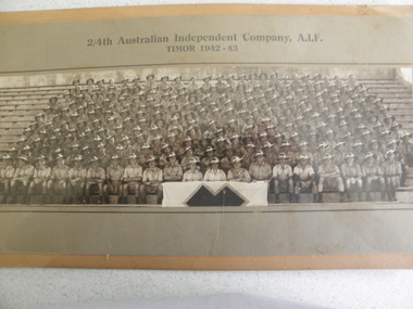
Photograph, 2/4th Independent Company, circa 1943
This photograph is of 2/4th Independent Company A.I.F Timor 1942-43.This Company was formed in December and posted to Katherine, NT, in March 1942. The Company was deployed to areas between McArthur and Ord Rivers and in August moved to Adelaide River. In September the Company moved to Darwin and boarded the destroyer HMAS Voyager and travelled to East Timor (then Portuguese Timor) to reinforce 2/2nd Independent Company.This photograph is the 2/4th Independent Company Members that served in East Timor 1942-43.A photograph attached to cardboard in a metal frame. The Photograph is covered by perspex instead of glass.2/4th Australian Independent Company, A.I.F. Timor 1942-43.east timor, a.i.f. 2/4th independent company. 1942-43. -
 Federation University Historical Collection
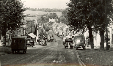
Postcards - black and white, Butt Bourton, Burford
Burford is a small town on the River Windrush in the Cotswold hills in west Oxfordshire, England, about 18 miles (29 km) west of Oxford, 22 miles (35 km) southeast of Cheltenham and only about 2 miles (3 km) from the Gloucestershire boundary. The toponym derives from the Old English words burh meaning fortified town or hilltown and ford, the crossing of a river. (Wikipedia)A streetscape photographic view of Burford, England showing buildings, cars and people. chatham family archive, burford