Showing 10533 items
matching lander
-
 Bacchus Marsh & District Historical Society
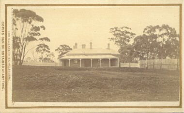
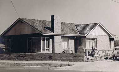
Photograph, The Bungalow, house built for Doctor Rae, Bacchus Marsh 1883
This image is one of a series of photographs taken by Melbourne based photographers Stevenson and McNicoll who visited Bacchus Marsh and its nearby districts between September and November 1883. The house was built for Dr. Rae in 1880 following his retirement from his medical practice due to ill health. He lived there until his death. Dr. Vance then occupied it for a short time. It was bought by the sisters of St. Joseph in 1890 and formed the nucleus of St. Joseph’s Convent. It was demolished in the early years of the twentieth century, when a new two-storey brick convent was built.Small sepia 'carte de viste' style unframed photograph on card with gold border framing photograph. Housed in the Jeremeas Family Album which contains photographs of Bacchus Marsh and District in 1883 by the photographers Stevenson and McNicoll.The photo is of a large single-storey brick house with a return verandah supported by simple columns. Five chimneys can be seen. The house sits on a large block of land in a bush setting, with a hedge separating the house and garden. A picket fence runs across the block, with a paling fence along the northern side.Printed On the front: Stevenson & McNicoll. Photo. 108 Elizabeth St. Melbourne. COPIES CAN BE OBTAINED AT ANY TIME. On the back: LIGHT & TRUTH inscribed on a banner surmounted by a representation of the rising sun. Copies of this Portrait can be had at any time by sending the Name and Post Office Money Order or Stamps for the amount of order to STEVENSON & McNICOLL LATE BENSON & STEVENSON, Photographers. 108 Elizabeth Street, MELBOURNE. stevenson and mcnicoll 1883 photographs of bacchus marsh and district, doctors, houses bacchus marsh, convents, religious residences -
 Ringwood and District Historical Society
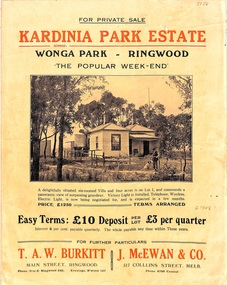
Flyer, Land Sale Brochure, Kardinia Park Estate, North Ringwood, Vic. - circa 1948
Folded buff-coloured land sale advertisement for Kardinia Park Estate in Warranwood area of North Ringwood, including terms of sale, area map, layout plan of the estate, and summary of local facilities and services. Front page features photograph of a man and dog in front of a house captioned as Lot 1 on four acres shown on the estate layout as cnr of Brysons Road and Range View Parade (later Omeo Parade). Second page includes bushland swimming pool photograph and promotional information for prospective buyers.Subdivision includes Kardinia Crescent, Wonga Road, Brysons Road, Range View Parade (later Omeo Parade), Motor Coach Road (later Wonga Park Road, then Warranwood Road). (Agent/s) T.A.W. Burkitt, Main Street, Ringwood, Phone (9 to 6) Ringwood 242, Evenings, Ringwood 157, and J. McEwan & Co, 317 Collins Street, Melbourne, Phone 6750 Central. -
 National Vietnam Veterans Museum (NVVM)
Poster - Poster, Information Board, 5RAR "Operation Canberra" 6th-10th Oct 1966
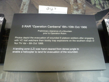
A black board with white text about "5RAR "Operation Canberra"6th-10th Oct 1966"5RAR "Operation Canberra" 6th-10th Oct1966 Premilinary clearance of a Mountain prior to Operation Robin. Photos depic the evacuation of wounded 8 platoon soldiers after engaging with VC trail watchers then booby trap explosions on the southern slope of Nui Thi Vai - 8th Oct 1966 A landing zone (LZ) was hand cleared from dense jungle to enable a helicopter to land for evacuation for the wounded.honours and awards, 5 rar -
 Kyneton RSL Sub Branch
Honour Board, VHLF
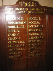
Timber board with gold lettering of names in two columns.Your Memory hallowed in the land you loved Allchin C Hood JL Armstrong N Hood W Birrell JR Hopewell AJ Burt A Kerr RA Camm J Knight JM Craig J Maddern ER Crozier RT Nicholson AJ Curtain JA Power RJ Downing JJ Skehill T Govey D Walsh VJ Govey EC Weatherall VD -
 Ringwood and District Historical Society
Flyer, Subdivisional Land Auction Sale Brochure, Grand Central Estate, Ringwood, Vic. - 1925
Douglas Street shown in the estate plan did not eventuate, but was developed as a public reserve. Refer also to Reg. No. 5149 for 1924 auction sale of land also titled Grand View Estate situated further north in Ringwood.Double sided multi-folded page advertising public auction sale on Saturday, 31st October, 1925, of residential allotments highlighting local facilities, services and layout of the estate. Includes panoramic view of Ringwood and other local photographic images.Subdivision includes Great Ryrie Street, Heathmont Road, Douglas Street, Garden Street, and Bellevue Avenue. Agents - Knight & Harwood, 315 Collins Street, Melbourne, Phone 10615, 10616 Central, in conjunction with J.B. McAlpin, Opposite Railway Station, Ringwood. Phone Ringwood 7. -
 Greensborough Historical Society
Book, Typical Homes that would be constructed by Mitchell Trading Pty Ltd, 1960_
An early advertising brochure for prospective homeowners to choose the style of home they would like built. House and land packages were available in the areas of Bundoora surrounding the Loyola and Parade College sites, which were monasteries in the 1960s. The aerial photographs show the open nature of the landscape from Bundoora across to Greensborough and Watsonia in the 1960s. Book of black and white photographs bound in brown card cover. Contains 14 photos of houses and shops and 14 aerial photos of Bundoora including the Loyola and Parade College areas. Includes notes from Gary Partington.In pencil inside front cover: 29/1/1960.houses, bundoora, greensborough, watsonia, loyola college, parade college, mitchell trading, aerial photography -
 Greensborough Historical Society
Memoir, Life at Alwyn - 1950s and 60s by Faye Fort, 1947-1969
Faye recounts stories about growing up in the Partington home "Alwyn" in the mid 20th century. At this time agriculture played an important role in the Greensborough district and the land around Alwyn was used for poultry, vegetables and cut flowers.A primary source recollection of Greensborough in the mid-20th century.2 typed pages. partington family, greensborough, alwyn, alan partington, farming -
 Greensborough Historical Society
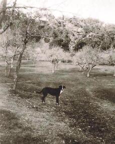
Photograph - Digital image, Old orchard at Partington Flat, 1930c
Remnants of the Partington orchard at Greensborough on land that is now the Partingtons Flat reserve in Greensborough. Charles Partington and family came to Melbourne in the 1840s and moved to Greensborough where they farmed along the Plenty River. This dog belonged to Jessie Partington.Digital copy of black and white photograph.partingtons flat, partington family -
 Kiewa Valley Historical Society
Maps - Kiewa Valley Parish Maps x3 and Kiewa Area Planimetric Map x1
Planimetric maps are 2 dimensional representations of the Earth's surface, showing the location and spatial arrangement of features such as roads, buildings, and bodies of water. The parish maps show the occupiers with leases or licences of the land. These are updated by the Department of Lands regularly. The names of early settlers of the Kiewa Valley occupying land by lease or licence are shown. Many of these familie's descendants still live in the Kiewa Valley.1. Kiewa Area Planimetric Map (photo) 2. Wermatong, County of Bogong Parish Map 3. Mulllindolingong, County of Bogong Parish Map 4. Mullagong, County of Bogong Parish Map All black and white kiewa valley. parish maps. land owners -
 Orbost & District Historical Society
cape, Before 1922
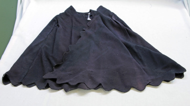
This cape comes from the estate of James Cameron who was one of the first Snowy River councillors for the Tambo Shire. He selected land at Lochiel in 1892. From 1902-1920 he was the Assembly member for East Gippsland.A black shoulder cape made of crepe silk. It has scalloped edges and is probably hand-made. It fastens with press studs and the hems have been machined.cape silk clothing -
 Eltham District Historical Society Inc
Photograph, 32 Piper Crescent, Eltham, 16 May 1990, 16/05/1990
Peter Conlan (via MysteryMonday website post) FEBRUARY 13, 2018 AT 12:13 PM: Photo is 32 Piper Crescent and the land to the right (behind the fenceline) is now the back of the properties at 1 to 4 Artists Hill.Roll of 35mm colour negative film, 2 stripsKodak GB 200 5096artists hill, eltham, houses, streets -
 Eltham District Historical Society Inc
Photograph, 32 Piper Crescent, Eltham, 16 May 1990, 16/05/1990
Peter Conlan (via MysteryMonday website post) FEBRUARY 13, 2018 AT 12:13 PM: Photo is 32 Piper Crescent and the land to the right (behind the fenceline) is now the back of the properties at 1 to 4 Artists Hill.Roll of 35mm colour negative film, 2 strips (composite of three frames)Kodak GB 200 5096artists hill, eltham, houses, streets -
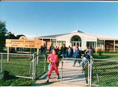 Hume City Civic Collection
Photograph, early 1980s
Goonawarra Primary School was opened in the early 1980s to accommodate children who were living in the Goonawarra Housing Estate. Prior to development this area was known as Goonawarra Farm and John McMahon grazed his dairy cattle on the land.A coloured photograph of the Goonawarra Primary School and main gate with school children leaving the grounds. A girl dressed in a pink tracksuit is at the gate.state education, schools, goonawarra primary school, goonawarra housing estate, goonawarra farm, ministry of education, george evans collection -
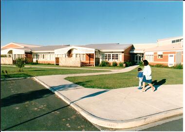 Hume City Civic Collection
Photograph, early 1980s
Goonawarra Primary School was opened in the early 1980s to accommodate children who were living in the Goonawarra Housing Estate. Prior to development this area was known as Goonawarra Farm and John McMahon grazed his dairy cattle on the land.A coloured photograph of the recently completed Goonawarra Primary School. A lady and little boy are walking along the footpath in front of the building. There is an expanse of lawn between the path and the building.state education, schools, goonawarra primary school, goonawarra housing estate, goonawarra farm, ministry of education, george evans collection -
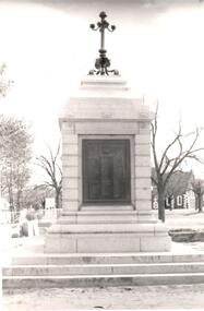 Hume City Civic Collection
Photograph, post 1972
The Sunbury War Memorial is situated on a triangular section of land which was once at the intersection of Barkly and Stawell Streets. The precinct is also the site of the Rupertswood Gun and the Starkey Fountain. All are important historical exhibits related to Sunbury's history.A black and white photograph of a front view of the Sunbury War Memorial. The memorial has been placed on 3 steps at the base with a metal tablet set in a stone surround. There is a decorative metal pole at the top of the memorial. St. Mary's Church is in the background.war memorials, village green, st. mary's church, george evans collection -
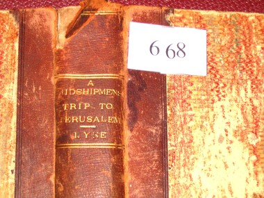 Stawell Historical Society Inc
Book, Augustus A. Lyne R.N, A Midshipman’s Trip to Jerusalem, 1871
This book at one time belonged to the Pleasant Creek Library and Mechanic Insititute, Quartz Reefs. The Adventures of a cavalcade of British Naval Officers in the Holy Land. Dedicated by permission to: Captain George Lethbridge R.N. and the Officers of H.M.S. TrafalgarBrown Spine and Cornors, front and back patterned paper cover, part missing, clear tape on spine top and bottom. Top Right Inside Cover J.W. Evans & Co. Binders 11A Flinders Way. Notice pasted on inside of front Cover. No. 1313. Pleasant Creek Library and Mechanics Institute Quartz Reef. Members will be held responsible for any damage done to books in their possession.stawell education -
 Whitehorse Historical Society Inc.
Photograph - Black and white photo, Winlaton Youth Training Centre
A house on the site was originally owned by successful businessman , Joseph Tweedle before being sold to the government. For many years it was the Winlaton Training Centre for girls. When the institution was closed the buildings were demolished and the land subdivided for housing.Four girls standing in the grounds of Winlaton outside a building.winlaton youth training centre, nunawading -
 Brimbank City Council
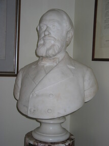
Marble bust on pedestal, W Taylor JP. The late executive coroner, 1934
William Taylor was one of the original white settlers in the area around modern day Keilor. He had a large amount of land and ran sheep in the area. Taylors Lake and Taylors Creek now bear his name. Figure of local historical significanceMarble bust on pedestalInscription on plinthwilliam taylor -
 Kew Historical Society Inc
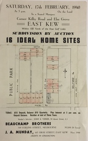
Plan - Subdivision Plan, Subdivision by Auction: 16 Ideal Home Sites, East Kew, 1940, 1940
An advertisement for the sale of a subdivision by Auction: of 16 Ideal Home Sites, East Kew, 1940. This significant sale of land between the Kew Golf Course and Willsmere Park led to the streets having a high degree of architectural uniformity.The subdivision in the second year of the war indicates that land sales for homes and speculation continued from the 1930s into the period of the Second World War. There is no indication on the plan that a war is occurring.Single page subdivision plan advertising the sale by Auction of 16 Ideal Home Sites, in East Kew, on 17 February 1940. Streets named in the plan include: Kilby Road, Belford Road, Elm Grove, Willow Grove. Willsmere Park is indicated but not named. The auction was conducted by Beauchamp Brothers. A number of lots are coloured pink on the plan indicating those lots for sale and/or those already sold.subdivision plans - kew east (vic) -
 Whitehorse Historical Society Inc.
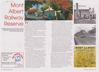
Article - The Bulletin article, The Bulletin, Mont Albert Railway Reserve, March-may 2021
After the Mont Albert Railway Station opened in 1890, 50 ratepayers petitioned the Nunawading Council to oppose the sale of the railway reserve to the north in order for it to become a recreation reserve.After the Mont Albert Railway Station opened in 1890, 50 ratepayers petitioned the Nunawading Council to oppose the sale of the railway reserve to the north in order for it to be a recreation reserve.non-fictionAfter the Mont Albert Railway Station opened in 1890, 50 ratepayers petitioned the Nunawading Council to oppose the sale of the railway reserve to the north in order for it to become a recreation reserve.mont albert, railway stations, surrey hills golf club -
 Warrnambool and District Historical Society Inc.
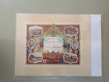
Certificate - Royal Review 1901 G Rolfe, 1901
This certificate was sent to those who had been present at one of the celebrations in connection with the Federation of the six States of Australia in 1901 – The Royal Review at Flemington Racecourse on 10th May 1901. The invitation to attend the event was issued by the Government of Victoria. The certificate was intended to be kept as a souvenir of the event and framed. This particular certificate was issued to George Rolfe and his wife of Warrnambool. George Rolfe (1836-1919), a tea merchant from Melbourne, began buying blocks of land near the mouth of the Hopkins River in Warrnambool in the 1870s. By the early 1880s he had acquired 50 acres of land in the town and several farming properties. He used the buildings on the land near the mouth of the Hopkins River as holiday accommodation and called the property, Lyndoch. He improved the property by adding stables, chaff and bone sheds, jetty, boathouse, reservoir, water well and windmill and extensive gardens and he spent most of his later life in the Warrnambool area. Lyndoch today is the site of an aged care facility. This certificate is of considerable importance for two reasons: 1. It is an important memento of a signal event on Australia’s history – the Federation of the six States in 1901 and the subsequent celebrations. 2. The certificate was issued to a prominent Warrnambool person, George Rolfe and his wife.This is multi-coloured sheet of paper mounted on card. There are four black and white photographs of the Royal Review at Flemington and photographs of the Duke and Duchess of Cornwall and York. The images include the Royal Crest, the shields of the six Australian States, a shield of Victoria with a background of flags, cannon and ammunition, two mounted soldiers with a soldier and sailor standing nearby and swords and bayonets. There is also much colour decoration around the edges of the certificate. The names of Mr and Mrs Rolfe are handwritten in black ink. ‘Australian Commonwealth Celebrations’ ‘The Government of Victoria requests the honour of the presence of Mr & Mrs G. Rolfe at the Royal Review at Flemington on Friday the 10th of May 1901’ federation of australian states, george rolfe of lyndoch, history of warrnambool, george rolfe -
 Warrnambool and District Historical Society Inc.
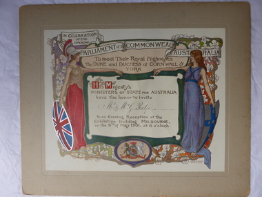
Certificate, Duke of Cornwall
This certificate is an invitation to the Evening Reception in Melbourne in 1901, an event which was part of the celebrations in Melbourne to commemorate the Federation of the six colonies into the six States of Australia in January 1901. The certificate was sent to the invitees after the event as a souvenir of the occasion. The certificate was designed by the artists Julian and Howard Ashton and lithographed and issued by Sands and McDougall Limited of Melbourne. This particular certificate was sent to George Rolfe and his wife Annie. George Rolfe (1836-1919), a tea merchant from Melbourne, began buying blocks of land near the mouth of the Hopkins River in the 1870s. By the early 1880s he had acquired 50 acres of land in the town and several nearby farming properties. He used the buildings on the land at the mouth of the River Hopkins as holiday accommodation and called this property Lyndoch. Rolfe improved this property adding stables, jetty, boathouse, bone and chaff sheds, reservoir and windmill and extensive gardens. Rolfe spent most of his later life at Lyndoch. Today the property is the site of an Aged Care Facility. This certificate is of considerable importance for two reasons: 1. It is an attractive and valuable memento of a signal event in Australia’s history – the Federation of the States in 1901. 2. The certificate was an invitation to Mr and Mrs George Rolfe. Rolfe was a prominent person in Warrnambool in the late 19th and early 20th centuries. This is a multi-coloured certificate mounted on a piece of grey cardboard. The certificate is highly embossed and has a figure of Britannia in a red dress and a mailed vest holding a shield with the Union Jack emblem. Britannia is extending her hand to a figure of a younger woman representing Australia. This figure is dressed in blue and holds a shield which has a blue cross with white stars. The borders have vines and vine leaves and the Royal Crest is at the base of the certificate. The names of the invitees are handwritten in black ink. ‘In Celebration of the Opening of the Parliament of the Commonwealth of Australia, To Meet Their Royal Highnesses, the Duke and Duchess of Cornwall and York, His Majesty’s Ministers of State for Australia have the honor to invite Mr & Mrs G. Rolfe to an Evening Reception at the Exhibition Building, Melbourne on the 9th of May 1901, at 8 0’clock’. george rolfe of lyndoch, warrnambool, federation of australia, history of warrnambool, george rolfe -
 Eltham District Historical Society Inc
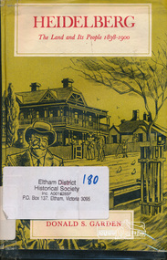
Book, Melbourne University Press, Heidelberg: The Land and its People 1838-1900 by Donald S. Garden, 1972
Although Heidelberg was one of the first parts of the Port Phillip District to be settled, and became important and prestigious in the early years of the colony, its history has been largely neglected. The beauty and fertility of the land and its proximity to Melbourne quickly resulted in the establishment in the 1830s and 40s of large estates by wealthy gentlemen. A romantic spot, Heidelberg became popular with picnickers and later attracted an artists' colony. The character of the area then gradually changed as a distinct village community emerged, and market gardens began to flourish. Unlike some of the suburbs closer to Melbourne, Heidelberg eventually wilted under economic pressures from which it did not fully recover until the turn of the century. This book allows us within the larger contect of the colony's fortunes and misfortunes, the struggle of Heidelberg the suburb to be born " - flyleaf. Contents: First land sales and subdivisions, gentlemen of Heidelberg and their estates and activities, infant rural community. golden fifties, decline and backwater, railway and land boom, a maturing community , the depression of the nineties. This book was the first to focus on the area of Heidelberg and its context within the Port Phillip District and remains significant as a key secondary source for describing the history of the area. It is relevant to the contextual history of its neighbour the former Shire of Eltham and Shire of Nillumbik.Hardback. Includes illustrations and index, 219 p.ISBN 0522840191port phillip district, ivanhoe, heidelberg, charles wingrove -
 City of Moorabbin Historical Society (Operating the Box Cottage Museum)
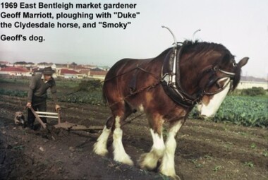
Photograph - Photograph: Horse-drawn Plough at Work, 1969 Geoff Marriott ploughing in his Market Garden, 1969
Members of the Marriott family arrived in Port Phillip in 1857. However it was John and Jane Marriott who in 1876, (after toiling hard since their arrival in1871, for very little gain), first leased, then purchased in 1882, 30 acres with a four-roomed house in East Boundary Road, in the area then called East Brighton. (Now known as East Bentleigh). The land they purchased had previously been a part of the 1841 Dendy Survey. Over the following years, John and his four sons with hard work and determination became prosperous vegetable growers and purchased further land in the area. Following John's retirement and subsequent death in 1903, the land was passed to his sons, and then onto the Marriott grandchildren. The family continued to remain very prosperous and successful vegetable growers. This lovely photo of Geoff Marriott bears testament to just one of the many families steeped in the tradition of vegetable growing which significantly contributed to the prosperity of the Shire, and its subsequent development into the City of Moorabbin. The photograph of Geoff Marriott of the Marriott family represents a typical example of the MANY early market gardening families, some names less prominent, but who with their labours contributed to the prosperity and the development of the community of the Shire of Moorabbin. This group of early pioneers, over many years, were a singularly important group responsible for the growth of schools, churches, the Mechanic's Hall, and were active in local government. Large coloured photograph, taken in 1969, showing Mr Geoff Marriott with his horse-drawn plough pulled by "Duke" the Clydesdale horse, and accompanied by "Smoky", his dog, working in his market garden, Brady Road, East Bentleighhorse, brighton, moorabbin, pioneers, settlers, fruit, markets, vegetables, plough, mayors, moorabbin shire, moorabbin roads board, marriott geoff, marriott john, marriott jane, market gardens, horse drawn plough, city of moorabbin -
 City of Kingston
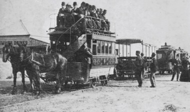
Photograph - Digital image, Black and white, c. 1900
The availability of reliable regular and frequent public transport was very important to the land speculators of the 1880s. Charles H James, an early land speculator, had large holdings in the Shire of Moorabbin at Black Rock, Sandringham and Mentone. In 1884 he was advertising the auction of 109 blocks of land at ‘Picnic Point’ in the Brighton Southern Cross.[1] He provided free railway passes and conveyance to the grounds to prospective buyers. A proposal to extend the Brighton Railway to Sandringham and Black Rock seemed remote in 1884 so James acted to resolve the lack of public transport by forming his own tramway company. From the discussion between the Council and James it was agreed that the Council would apply for permission to construct a tramway on Beach Road. By February 8, 1889 the horse drawn trams were running from Cheltenham Station to Rickett’s Point and from Sandringham Station to ‘Blackrock Corner’. Although stricken with financial problems for its entire existence, Beaumaris Tramway Company continued until 1915.Black and white image of two horses. harnessed to a double decker tram, being pulled along the tram tracks laid in the street. There are men sitting on the top level of the tram, in the open air. Other trams are lined up behind this one, although with no people in them. The tram belongs to the Beaumaris Tramway Company. -
 Surrey Hills Historical Society Collection
Photograph, Holy Trinity Tennis Club, 1941, 1941
Holy Trinity originally held their first organised services during 1885 in the recreation hall in Albany Crescent, Surrey Hills with the Reverend H E Taylor, then Vicar of St Barnabas, Balwyn, conducting the services. Mr E D Dyer donated the land for a church on the corner of Mont Albert Road and St George's Road, Mont Albert with the foundation stone being laid on 17 July 1886. The first church service was held on Sunday, January 30, 1887 with eighty people present. A new site on Union Road, Surrey Hills was acquired (lots 3 & 4) and a wooden church was erected and opened in 1907 on lot 4. It became known as Holy Trinity Surrey Hills. In November 1939 two tennis courts and a pavilion were erected on land acquired by the parish in a lane off Balmoral Crescent. The Holy Trinity Tennis Club had 80 years of distinguished success in match play until it closed in 2014. That land was sold in 2015 and the parish's real estate holdings diversified.Black and white photo of 9 ladies, in tennis dresses and shoes, and 8 men, also in tennis attire. They are posed next to a light coloured building on the right and a paling fence along the back left side. There are 5 men standing at back, 6 ladies and 1 man standing in the next row, 4 ladies sitting in front and 2 men sitting on the ground. Three ladies sitting are holding tennis racquets. There are trees behind the paling fence. Black and white photo mounted on card; photo measures W 11.1 cm x H 6.7 cm.sporting clubs, sports people, tennis, holy trinity anglican church, 1940 - 1949, mrs mary clucas -
 Ringwood and District Historical Society
Document - Folder, Commercial and Retail Property Sales Information, Civic Place and Melbourne Street, Ringwood - 1998
45 photocopied pages including - Plan of Subdivision No.LP80718, Parish of Ringwood, Victoria, Crown Portion 12(Part) and part of a former government road Ref Vol 8668 Fol 745. - Vendors Statement, Planning Certificate and Heritage Council (Victoria) Certificate issued for 20 Melbourne Street, Ringwood. - Maroondah City Council Land Information Certificate for 149 149A and 149B Maroondah Highway; number 8 Civic Mall; and numbers 16, 20, 22 & 24 Melbourne Street Mall. - Yarra Valley Water statements relating to encumbrances for Shop 11, 149 Maroondah Highway; Shop 10, 149A Maroondah Highway; Shop 9, 149B Maroondah Highway; numer 8 Civic Place; Unit 3, 20 Melbourne Street; Office 4, 20 Melbourne Street; Shop 7, 22 Melbourne Street; and Shop 8, 24 Melbourne Street. - Land Tax Certificate pertaining to Commonwealth Bank, Civic Place, Ringwood. - Certificate of Title Vol 8892 Fol 906, Lot One on Plan of Subdivision No. 80718, Parish of Ringwood - Hanover Developments P/L - 29th June, 1971. -
 City of Moorabbin Historical Society (Operating the Box Cottage Museum)
Newsletter, City of Moorabbin Historical Society Apr 2009, April 2009
The City of Moorabbin Historical Society was formed c 1960 by a group of Moorabbin residents who were concerned that the history of the area should be preserved. A good response to a call for items related to the historical area of Moorabbin Shire brought donations of a wide variety of artefacts which are now preserved by the current members of CMHS at Box Cottage Museum . Helen Stanley, Secretary of CMHS, began producing a Newsletter for members in April 2007 to provide current information and well researched items of historical interest.Helen Stanley has produced a bi-monthly Newsletter, 2007 - 2013, for the members of the City of Moorabbin Historical Society that contains well researched interesting historical items, notification of upcoming events, current advice from Royal Australian Historical Society , Museums Australia Victoria and activities of Local Historical Societies. The Newsletter is an important record of the activities of the CMHS.2 x A4 paper printed on 4 sides Issue 11 of the bi-monthly, City of Moorabbin Historical Society Newsletter produced by Society member and Secretary, Mrs Helen Stanley in April 2009. Notice that Mr Travis Sellars, Friends of Cheltenham and Regional Cemeteries, will talk about ‘The Tragic 20’s’ at the meeting April 26th . Volunteers are needed to show visitors around on Open Days each month and a Roster will be made on April 26th . Suggestions are requested for the Community Grant Application to be submitted by CMHS. Historical details are condensed from ‘ The Living Harvest’ by W.T Dobson, describing the establishment of St. Peter’s Catholic School East Bentleigh 1865 on land donated by Fred Quinn , in Centre Road, East Brighton ( East Bentleigh). A photo copy of Parts of Country Portion 39 of Dendy’s Special Survey or Brighton Estate showing the Land Sales of Lot 2, & 3 North Road and Jasper Road 1841 – 1869. Interesting note on the origin of ‘Jasper Road’. 3 photocopied photographs of St Peter’s School building 1903, School Children at East Brighton Railway Station, 1903, A Lorry in the parade 1903. CITY of MOORABBIN HISTORICAL SOCIETY / APRIL 2009 NEWSLETTERcity of moorabbin historical society, stanley helen, dobson w.t., melbourne, moorabbin, brighton, friends of cheltenham and reional cemeteries, cheltenham, ormond, bentleigh, market gardeners, irish immigrants c1850pioneers, early settlers, moorabbin shire, box cottage museum, port phillip bay, brighton estate, jasper road ormond, east boundary road brighton, dendy’s special survey 1851, point nepean road, south road brighton, thomas street brighton, north road brighton, county of bourke, box h., box william, parish of moorabbin, parish of prahran, markets, shingle roof, weather-board, mr., mckinnon, were jonathan, niall rev. fr. patrick, quinn fred, elsternwick, catholic church directory 1878, hibernian society melbourne, brady peter., kennedy mr., boland mr., leary mr., gahan mr., archbishop carr, rev. fr. gough., presentation convent gardenvale, sister mary vincent, charlston john, bavarian dress band, hales jasper