Showing 10432 items
matching sites
-
 Glenelg Shire Council Cultural Collection
Souvenir - Biscuit Tin - Portland Cable Trams, c. 2010
From a series of tins of biscuits sold in 2010 showing iconic Australian sites and vehicles. Sold thru Go-Lo (Chickenfeed) discount stores.Metal Macs butter shortbread biscuit tin with a relief image of the Portland Cable Tram on lid. -
 Ballarat Heritage Services
Photograph - Photograph - Colour, Dorothy Wickham, Ballarat Female Refuge, 2000
Ballarat Female Refuge was established in 1867 by a group of 26 Ballarat ladies. It was moved to the present site in Scott's Parade in 1884. It is now a private residence.Postcard size colour photgraphs showing the interior and exterior of the Ballarat Female Refuge. ballarat femail refuge, welfare, town and city mission, alexandra babies home, baby, orphanage, sarah ellis -
 Kiewa Valley Historical Society
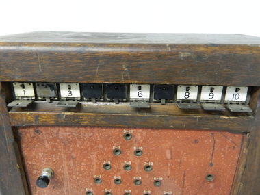
Console Telephone 10 shutter, circa early 1900s
This manual telephone exchange console is an important piece of equipment which provided the most efficient method of long distance communications in the 1950's to the 1980's. Communications were critical, not only for the regional Hospital, but also for large construction sites i.e. the Kiewa Hydro Scheme, especially if they are in dense rugged mountainous regions. The degree of Occupation Health and Welfare on industrial sites were at a bare minimum compared to the work scene after the 1980's.This telephone exchange console is highly significant to both the Kiewa Valley and Mount Beauty region because it was so important in the communications field relating to operational safety and work related controls. The success of any large undertaken relies heavily upon good communications. In the hospital this method of communications is still used i.e. patient to ward station. This flag system link a patient's room to the controlling nursing station. Identification of the patient needing help is crucial for swift action from the available medical staff. Similarly in large construction sites such as the Kiewa Hydro Scheme, successful instant communications was also essential. This switchboard required a 50 volt supply to successfully operate and was in use when both telecommunications and postal were under the one Federal Government carrier i.e. The Post Master General. A benefit with a line communication system (such as the one that fed this console was that interference from atmospheric conditions did not impede the connection.This console telephone switchboard (manual) unit has a shutter operation (precursor to the light indicator) to identify the caller to the telephone switchboard operator. This switchboard has a ten point indication shutter system allowing the operator to clearly identify where the caller is located. The console has a 44 connection point holes with their configurations in a triangular shape. The shutters are held closed by a small lever at the top which is opened by a small electrical charge from the incoming call. The operator uses a wind up handle to power a magneto connector(handle on the console's right side). The telephone hand set is located on the left side of the console. sec vic kiewa hydro scheme, alternate energy supplies, alpine population growth and communications -
 Greensborough Historical Society
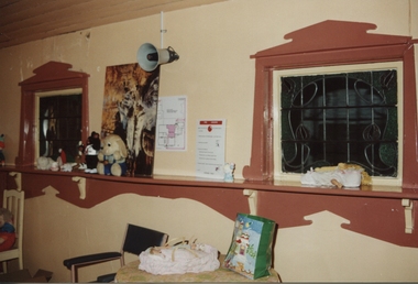
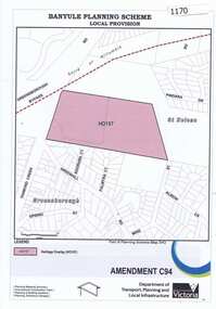
Map, Saxam Heritage Overlay, 2011_
"Saxam" was the home of the Kaye family (1886-1888) then William Santon, a former councillor and Mayor of Heidelberg. Saxam Homestead is a distinctive and substantial timber homestead built in the late 1880s as one of the notable rural properties in the St Helena area. In 2014 the house still stands but is in poor condition with most interior features removed. The site had a heritage overlay as shown. The overlay was reduced in 2014 to protect the house while allowing residential development on the site.Saxam is one of the only remaining farmhouses in the Greensborough area.Copy of map and planning scheme.saxam -
 Vision Australia
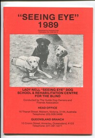
Administrative record - Text, "Seeing Eye" 1989 Lady Nell "Seeing Eye" Dog School & Rehabilitation Centre for the Blind, 1989
President's overview of defamatory media and government investigation of the school, reopening of the hostel at 2 Derril Avenue, Malvern, difficulty in obtaining pups, difficulties in not being able to expand at Thanet Street site and inability to use the Dingley site as intended due to the proposed freeway, inability to fundraise due to bad publicity, court action against Herald-Sun journalists, discussion over cases where dogs were removed and profiles of some people and their dogs. 1 volume with text and illustrationsannual reports, lady nell seeing eye dog school, phyllis gration -
 Otway Districts Historical Society
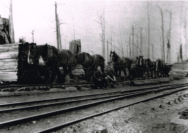
Photograph, Brucker, Pile Siding: horse-drawn timber tram, c.1920
Pile Siding was opened in December 1915 because of the Pettit Brothers sawmill and pile extraction operation. The siding was a spur with points facing Beech Forest with a timber tramway feeding the siding. During 1916/17 Pettit's sent away 5,000 tonnes of timber before moving to another site, after which loading dropped to insignificant proportions. Pettit's again occupied the site from 1924 and traffic rose to major levels again.B/W. A six horse-drawn timber tram at Pile Siding station in c.1920. Two timber workers are seated at the centre. Stacks of timber are awaiting collection. Note the bare tree trunks in the background. pile siding; weeaproinah; railways; tramways; -
 Federation University Historical Collection
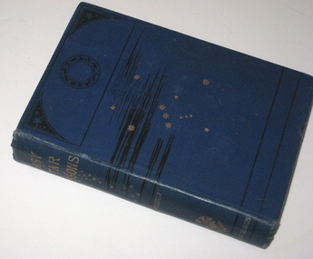
Book, Richard A. Proctor, Easy Star Lessons, 1881
In 1873 Teesdale residents formed an institute to provide literature to improve the minds. The site was gazetted on 25 October 1875 – a one acre site on the corner of Bridge Street and Mercer Terrace. A Mechanics Institute was built and later a supper hall was added in front of the institute. The mechanics institute and supper hall was destroyed by fire on the night of 29 March 1969. (http://linkingtowns.com/index.php?option=com_content&view=article&id=91&Itemid=252) Blue hard covered book of 239 pages. Many illustrations f constellations during each month. Inside front page 'Mechanics Institute Teesdale No 270'astronomy, library, teesdale, mechanics institute -
 Kew Historical Society Inc
Plan, J R Mathers & McMillan, 5 Splendid vVlla Allotments,: Segtoune St. & Windsor St., Kew, 1928
Prue Sanderson, in her groundbreaking ‘City of Kew Urban Conservation Study : Volume 2 - Development History’ (1988), summarised the periods of urban development and subdivisions of land in Kew. The periods that she identified included 1845-1880, 1880-1893, 1893-1921, 1921-1933, 1933-1943, and Post-War Development. These periods were selected as they represented periods of rapid growth or decline in urban development. An obvious starting point for Sanderson’s groupings involved population growth and the associated economic cycles. These cycles also highlighted urban expansion onto land that was predominantly rural, although in other cases it represented the decline and breakup of large estates. A number of the plans in the Kew Historical Society’s collection can also be found in other collections, such as those of the State Library of Victoria and the Boroondara Library Service. A number are however unique to the collection.Subdivision plans are historically important documents used as evidence of the growth of suburbs in Australia. They frequently provide information about when the land was sold on which a built structure was subsequently constructed as well as evidence relating to surveyors and real estate and financial agents. The numerous subdivision plans in the Kew Historical Society's collection represent working documents, ranging from the initial sketches made in planning a subdivision to printed plans on which auctioneers or agents listed the prices for which individual lots were sold. In a number of cases, the reverse of a subdivision plan in the collection includes a photograph of a house that was also for sale by the agent. These photographs provide significant heritage information relating house design and decoration, fencing and household gardens.In 1928, five residential allotments bordering Segtoune and Windsor Streets were advertised for sale as part of a subdivision. Four of the blocks faced Segtoune Avenue. The auctioneers proclaimed the advantages of the sites: ‘Situate one minute from the High Street Electric Tram, which now runs direct to Spencer Street via Bridge Road and Flinders Street. Opposite the East Kew Railway Station (Outer Circle Line), which may be reopened In connection with the new Line from Kew to Doncaster; Adjacent lo the Kew Recreation Reserve, Sports Oval, and Swimming Bath; Half Minute from the Shopping Centre of East Kew, Accessible to the State School and Other Educational Centres’. The Harp of Erin Hotel and the route of the Outer Circle Railway line are marked on the plan. The Recreation Reserve and Sport Oval refer to Victoria Park. The Swimming Baths were located on the site of the current Kew Recreation Centre.subdivision plans - kew, segtoune street -- kew (vic.), windsor street -- kew (vic.) -
 Wodonga & District Historical Society Inc
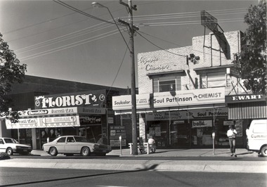
Photograph - Codling Collection 01 - Ewart Bros. Menswear, Soul Pattinson (previously Ken Moir), Darrell Lea, National Bank, Mid 1970s
Miss Olive Codling was a Foundation Member and a Life Member of the Wodonga Historical Society. Many of her prize-winning photos are held in the Society Collection. She also held a range of roles and committee positions in a wide range of Wodonga community organisations. These included the Horticultural Society, the Wodonga Arts Council, the Wodonga Camera Club and the Wodonga Lapidary Club. This photo collection is significant as it documents how the businesses and buildings in Wodonga have evolved and contributed to community throughout the 20th century.Geoff and Clarrie Ewart conducted a menswear business in High Street, Wodonga for 45 years. The pair began trading in 1954 at the southern end of the street before moving to a shop next to the Wodonga Pharmacy where they continued until 1995. They also opened Ewart's Book Store further south in High Street in 1961. Their second site became known as the 'long shop' as it extended from High Street and through to the Coles supermarket car park. They closed their menswear business in 1995. It was eventually absorbed by Coles when they extended their store, Jannoel Florist in Seasame Street was opened late 1973 - back then the Darrel Lea shop was Harry Johnsons shoe shop and after that it was Toyworld then it became Darrel lea before Jannoel bought Darrel Lea in 1998 knocked a hole in the wall and began combining flowers and chocolates Coles building was commenced on the site of Stiff and Gannon in March 1971 wodonga businesses, high st wodonga, ewart brothers, jannoel florist -
 Wodonga & District Historical Society Inc
Album - Hume Reservoir Australia Album - View from the Victorian bank of the Murray River, May 1923, 1927
This set of photos is from a leather bound album bearing the inscription "HUME RESERVOIR AUSTRALIA" plus 'The Rt. Hon. L. C. M. S. Amery, P. C., M .P.' all inscribed in gold. It was presented to The Rt. Hon. L. C. M. S. Amery, P. C., M. P, Secretary of State for Dominion Affairs on the occasion of his visit to the Hume Reservoir on 2nd November 1927. This album is of local and national significance as it documents the planning and development of the Hume Reservoir up to 1927. It was the largest water reservoir in the British Empire. The album records the pioneering engineering work that went into its construction.DEPARTMENT OF PUBLIC WORKS, N.S.W. RIVER MURRAY WATERS SCHEME. HUME RESERVOIR. 12. View from the Victorian bank of the river showing in the foreground a levee bank along the New South Wales side of the river with connecting wings back to the higher ground, May 1923. The first stage in the construction of the Dam foundations was carried out inside the levee bank which was at a sufficient height to protect from floods the work going on inside. A length of 300 feet of the Dam was left at a low elevation to allow of the river flowing over it in the second stage of the operations and at the ends of the concrete was brought up above flood level. To divert the river, a Coffer Dam was built across the old bed above and below the Dam site and tying into the end of the concrete wall built inside the levee bank. This completely surrounded the remainder of the site of the Dam and south wing wall, including an area of 12½ acres.hume reservoir australia, river murray waters scheme, hume reservoir construction -
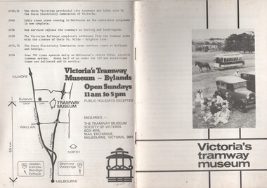 Melbourne Tram Museum
Pamphlet, Tramway Museum Society of Victoria (TMSV), "Victoria's tramway museum", mid 1970's to July 1982
Set of two pamphlets or booklets, titled "Victoria's tramway museum", providing details of the Tramway Museum Society's TMSV collection, the site and its exhibits and a brief time line history of Victoria's tramways and a location map on the rear cover. See Reg Item 5151 for a print of the photograph that was cropped for the front cover. .1 - 12 pages -folded A5 size - white cover - centre stapled - has a photo of the Royal Park horse tram operating on the Bylands site - mid 1970's? See Reg Item 5151 for a print of the photograph that was cropped for the front cover. .2 - 12 pages - folded A5 size - blue cover, white sheets internally - centre stapled - has the TMSV logo on the front cover - late 1970's. .3 - as above, white cover with an tram front image on the front cover, has "Interim edition July 1983 - internal connects the same as .1.1601.2 - has a price lable of 20c on the front cover.trams, tramways, tmsv, bylands, museums, horse trams -
 Bendigo Historical Society Inc.
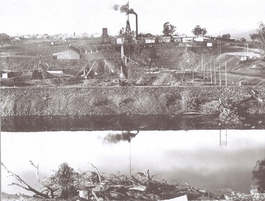
Document - DEBORAH REEF PROJECT ENVIRONMENT EFFECTS STATEMENT
Two page document. On top, first page ' Bendigo Mining N.L., Deborah Reef Project, Environment Effects Statement, Summary Brochure'. Poppet head on top LH corner of document. A map of central Bendigo is drawn on page 1 and shows the location of the proposed processing plant near the Airport. Further maps on page 2 and 3 show the North Deborah Mine Site, the pipeline route and the airfield site. The summary brochure provides an outline of the material contained in the Environment Effects Statement and proposed planning scheme amendments upon which, the Deborah Reef Project will be assessed. Page four lists the issues that impact on this submission: planning and land use; socio economic environment; traffic; discharges to air; water management; explosives storage and handling; subsidence; heritage; flora and fauna and landscape and visual assessment. The 16th March, 1989, is the date given for submissions to be lodged in regard to this project.Bendigo Mining N.Lbendigo, mining, deborah reef project -
 Bendigo Historical Society Inc.
Document - MERLE HALL COLLECTION: DOCUMENTS RELATING TO FEASIBILITY OF BENDIGO ARTS CENTRE 1981 TO 1982
Various documents relating to feasibility of Bendigo Arts Centre 1981-1982: Correspondence re survey of potential user groups (Ross Ramus Architects) - two sites to be evaluated as part of that study - Central Bendigo site & BCAE, Flora Hill; Shire of Strathfieldsaye notification of proposed Bus Tour of performing arts centres in Melbourne; Reports of the Liaison Sub-Committee regarding Performing Arts Centre - minutes of meetings of 15/12/1981 and 22/4/1982; Revised List of User Groups per Bendigo Arts Council - addresses and names of Groups (some defunct); 9-paged document entitled ''History of Existing Policy'' covering history since the establishment in 1974 of the Regional Arts Centre Program - a Ministry for the Arts publication?) with details of state-wide commitments to thirteen arts centres - Bendigo having ''commitment in principle'' with four already in existence prior to the commencement of the program. -
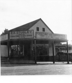 Greensborough Historical Society
Photograph - Digital image, Stubley's Furniture, 1958c
Stubley's Furniture Store late 1950s. The Stubley Group began in 1946 when Purcell Stubley purchased a site with petrol bowsers in Main Street from 'Snowy' Jessop. In 1948 Purcell began building the new Stubley Motors, working round the old site to keep the business operating. It was completed in 1951. The Group expanded into other areas such as this Furniture store. [Syd Thompson Fruit Shop was here in early 1950s, Syd lived in the house at back. He coached Boxing]. This became the Welkay Store in the 1960's and owned by Walter Kenyon. The Welkay store moved opposite to 100 Main Road on 6/9/1966, ref: Diamond Valley News Page 9. Soon after the store would have been demolished to make way for 'The Valley Building' still on the site in 2018.Digital copy of black and white photographpurcell stubley, stubley motors, stubley group greensborough -
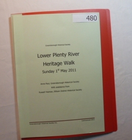 Greensborough Historical Society
Folder, Lower Plenty River Heritage Walk 2011, 01/05/2011
Contains information about the sites visited on the Heritage Walk 2011 through Yallambie and Viewbank. Notes compiled by Anne Paul with assistance from Russell Yeoman.20-page plastic binder, redcover. Contains 12 page guide.plenty river, heritage trail, anne paul, greensborough historical society, yallambie, viewbank, russell yeoman -
 Greensborough Historical Society
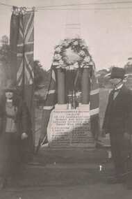
Photograph - Digital image, Fallen Soldier's Memorial Greensborough, 1923c
These photographs shows the World War I "Fallen Soldiers" Memorial at it's original site in Main Street Greensborough. Photographs appear to be taken early 1920s.The Memorial has been moved several times and is now situated the War Memorial Park in Henry Street Greensborough.Digital image of 2 black and white photographs.greensborough war memorial park, fallen soldiers memorial greensborough -
 Greensborough Historical Society
Newspaper Clipping, Diamond Valley Leader, Uni offers to sell Strathallan Golf Course land, 30/08/2017
La Trobe University has offered to sell the Strathallan Golf Course land to Darebin Council after years of speculation over the future of the Bundoora site.News article 1 page, black text, colour image.la trobe university, strathallan golf course, darebin council -
 Greensborough Historical Society
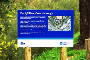
Photograph - Digital image, Marilyn Smith, Plenty River bank stabilisation 2015, 16/08/2015
River bank stabilisation project along the Plenty River at Greensborough 2015, conducted by Melbourne Water. Project sign and close-up of aerial view of site.Digital copy of colour photographplenty river, melbourne water -
 Federation University Historical Collection
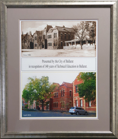
Photograph, Ballarat School of Mines Lydiard Street South
The framed photographs were presented to University of Ballarat to commemorate 140 years of Technical Education. The Ballarat School of Mines was the first site of technical education in Australasia.Framed photographs of two views of the Ballarat School of Mines Administration Building. The first was was taken c1901 and shows the former Ballarat Circuit Couthouse (now demolished) and the original front of the former Ballarat Wesleyan Church. The second photo was taken in 2010 and shows the former Wesleyan Church, the Administration Building and the Ballarat Technical Art School. Presented by the City of Ballarat in recognition of 140 years of Technical Education in Ballarat.ballarat school of mines, administration building, new classroom, ballarat circuit court, ballarat wesleyan church, a building, anniversary, available -
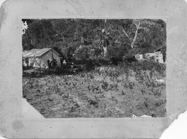
 Kiewa Valley Historical Society
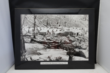
4 Photos framed - Kiewa Hydro Electric Scheme 1940s
These 4 black and white photos are very clear and are of Bogong in the 1940s when the Kiewa Hydro electric Scheme was being constructed. Bogong was the first construction site. Bogong was a township and construction site for the Kiewa Hydro Electric Scheme built by the State Electricity Commission of Victoria. These photos in the early 1940s (during WW2) tell the story of fire, flood and living conditions with the inference of transport being horses in 1940 compared with its development in 1944.1. Tent camp at the 'Junction', Bogong 1940 2. Junction Dam September 1940: floodwaters over coffer dam 3. 'Reservoir' Camp with Bogong Stables in foreground, 1940 4. Junction Dam and Bogong village in August 1944 Each photo has string attached on the back with tape - for hangingSticker on the back of each photo: 'Framing/ Colour Magic / Shop 7, Lismore Central / Carrington Street, Lismore / Phone (02) 6621 3289'bogong township 1940, junction dam 1944, reservoir camp 1940, bogong stables 1940, tent camp at bogong -
 Orbost & District Historical Society
nails, 1890's
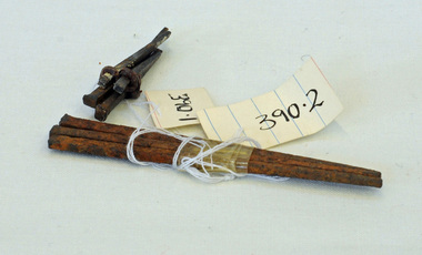
These hand-made nails were used in what was Temple's Store built in 1889. It later became Herbert's - now demolished and is the present site of the Foodworks Supermarket.Temple's store was on the corner of Ruskin Street and Nicholson Street. George Temple (1832-1918) established the store in about 1888. He packed stores to the Bendoc area gold fields.Two lots of hand-made nails. .1 is a set of five small nails tied together with string. .2 is a set of three longer nails which are very rusty.nails metal-working temples-store -
 Emerald Museum & Nobelius Heritage Park
Primus Stove
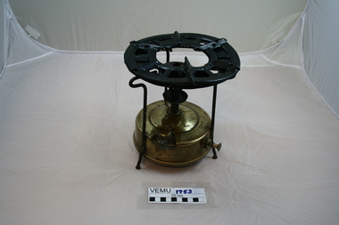
The stove was the property of John Biggart, who lived in Avonsleigh. He travelled Victoria from 1920 to the 1940's. The stove was used at a work camp site.Brass base containing the kerosene fuel tank, above which rises a burning tube and burner assembly. The steel top rings are held above the burner by 3 support legs. To light the stove, a small amount of alcohol is put into the spirit cup, just below the burner to preheat it. Kerosene was then vaporised, mixed with air and it burns with a soot less, blue flame.PRIMUS No. 1. MADE IN SWEDEN. TRADEMARK PRI-MUS. PATENT SB. No 48624. ENG No 171536, all on the top of the tank. On the side is engraved; A/B B. AHJORTH AND CO. STOCKHOLM SWEDEN - SOLEMAKERS OF THE GENUINE -
Tatura Irrigation & Wartime Camps Museum
Photo album, Tatura Historical Society Trip 1993, 1993
Compiled into album from photographs taken by members on trip to places of historical interest in Denilquin and Hay. Railway Station. Plaque on site of Hay POW Camp.White plastic coated photo album with red, gold and brown stripe.tatura historical society -
Tatura Irrigation & Wartime Camps Museum
Video Tape, Wartime Camps
Talk given by Lurline Knee to the annual meeting of the Regional Historical Group 1995 and walk through Camp 1 site. Filmed by Tom Hanrahan, Rochester.Akai E180 video taperegional historical group, camp 1, tom hanrahan, lurline knee -
 Stawell Historical Society Inc
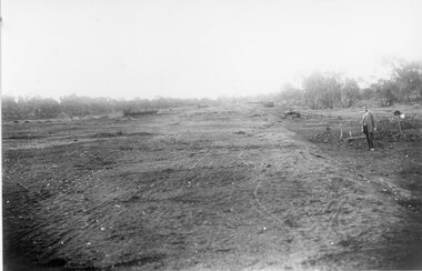
Photograph, Stawell Wheat Site Construction beside the main rail line behind the Pleasant Creek Training Centre and Woollen Mills -- Demolished 1945-1946
Building Stawell Wheat Site situated beside the main rail line behind the Pleasant Creek Training Centre and Woollen Mills. Demolished 1945-1946stawell -
 Surrey Hills Historical Society Collection
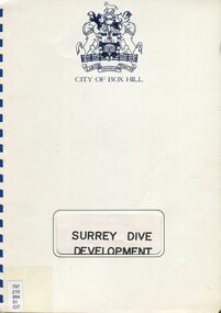
Book, Surrey Dive Development, Nov. 1986
A report on the proposed development of the Surrey Dive and adjacent areas. It includes topography, site services, buildings, usage of the area including fishing, boating, model boats.An A4 spiral bound report.surrey dive, box hill brick company, surrey park, shire of nunawading, scott and furphy engineers pty ltd, box hill -
 Kew Historical Society Inc
Photograph, Sunday School, Congregational Church, Walpole Street, c.1900
The Congregational Church in Walpole Street, Kew (now demolished) was designed by Albert Purchas. The second church was built on the site of an earlier church designed by Charles Vickers.Sepia photograph on board of Sunday School students and teachers from the Congregational Church in Walpole Street. Reverse: "Kew Congregational Church / ? Sunday School. Miss A. Millist" [donor]. circa 1900"churches -- kew (vic), congregational church -- kew (vic), sunday schools -- kew (vic), walpole street -- kew (vic.) -
 Halls Gap & Grampians Historical Society
Photograph - B/W
This is a photo of a camps site at the base of Mackeys Peak. The Willoughby's are camped on the left, The Barnes in the centre and the Hines on the right (presumably the people in the photo are from these family groups).The photo shows tents in a clearing in bush.There is a large tent to the right with a man and a young child in front of it, another tent or structure can be seen on the left with a group of four adults and two children lined up in front of it. A buggy can be seen in the bush in the centre.Camp at base of Mackey's peak, Willoughby's camp, Barnes Camp Hines Camp, written in pen on back of mount.recreation, camping, scenery, grampians ranges -
![Sign, Regulations for the Care, Protection and Management of the " Penguin Reserve" at Phillip Island [ As amended ] 1956 and 1968, 1956 and 1968](/media/collectors/4f729f5b97f83e0308601629/items/6476aa1f1e1a2671cef44090/item-media/6476ab3b1e1a2671cef4be40/item-fit-380x285.jpg) Phillip Island and District Historical Society Inc.
Phillip Island and District Historical Society Inc.Sign, Regulations for the Care, Protection and Management of the " Penguin Reserve" at Phillip Island [ As amended ] 1956 and 1968, 1956 and 1968
Board of Land and Works reserved land on Phillip Island by Orders in Council in December 1955 and June 1956 as sites for a penguin rookery and known as the Penguin Reserve.HistoricalLarge cream cloth sign with black print outlining regulationswildlife - penguins, penguin reserve, phillip island nature park, signs -
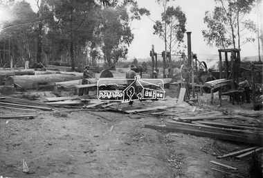 Eltham District Historical Society Inc
Photograph, Sawing timber at Hurstbridge
Workmen working with cut logs and a circular saw blade in an outdoor setting at Hurstbridge. In 1920 the Hurstbridge sawmill site was situated on 6 acres and was advertised for sale. This photo forms part of a collection of photographs gathered by the Shire of Eltham for their centenary project book, "Pioneers and Painters: 100 years of the Shire of Eltham" by Alan Marshall (1971). The collection of over 500 images is held in partnership between Eltham District Historical Society and Yarra Plenty Regional Library (Eltham Library) and is now formally known as 'The Shire of Eltham Pioneers Photograph Collection.' It is significant in being the first community sourced collection representing the places and people of the Shire's first one hundred years.Digital imagesepp, shire of eltham pioneers photograph collection, hurstbridge, timber mill, logs, lumber trade, timber, sawmill