Showing 10533 items
matching lander
-
 Warrnambool and District Historical Society Inc.
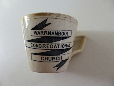
souvenir cup, Warrnambool Congregational Church
The Warrnambool Congregational Church was established with a meeting called in April 1862 and over the ensuing months a congregation with first pastor Rev W Pentland was established. After initially meeting at the small Temperence Hall in Liebig St, land was purchased at the corner of Liebig and lava St and the first church opened in March 1864. It remained on this site until the site was sold to the T & G Assurance in 1939 and land known as Kianga Estate was purchased on the corner of Lava and Henna Streets.It became part of the amalgamation with other churches to form the Uniting Church in 1977.This cup is possibly a souvenir from the 50th anniversary celebrations held in 1912. A common object which is linked to one of warrnambool's longest running churches.Cream china cup with thick gold rim and black test in banner style on one side of the cup. Warrnambool Congregational Church on front of cup . 338 written on bottom and 4 on paper labelwarrnambool, warrnambool congregational church -
 Warrnambool and District Historical Society Inc.
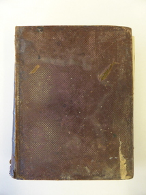
Book, The Domestic liturgy & family chaplain, 1846
This book belonged to John Cowtan. He was a purchaser of land near Cassady’s Bridge in Warrnambool and an important and early settler in Port Fairy. The land that John Cowtan selected was bought by Williaam Cassady whose sister, Ann, was married to John Cowtan. Cassady established the property, Boughton where Cassady’s Bridge is today. This book came from a Cassady estate sale early in the 21st century. Between 1839 and 1844 John Cowtan was a ship’s captain for John Griffiths, a shipowner and entrepreneur. In 1844 Cowtan established a merchant trading and produce business in Port Fairy with John Bland. In the 1860 John Cowtan went to live in Melbourne.This book is of great interest because of its early date (one year after the founding of Warrnambool) and because of its association with John Cowtan, a pioneer settler of Port Fairy with connections to Warrnambool.This is a brown leather cover book of 385 pages. The spine has gold lettering. The binding has come apart and has been mended with white cotton material on the inside of the cover. The insides of the cover have a brown, white, blue and yellow mottled pattern. The cover is stained and torn at the edges and has a deep gouging on the front. The first page has been torn and mended with tape and some of the pages are stained. There are two pressed fern fronds, one loose newspaper cutting and a bookmark with a sepia-coloured image, lace paper edges and coloured embroidery contained within the pages. The book has a preface and 58 chapters. The inscription is handwritten in black ink. ‘J. Cowtan 1848’ john cowtan, port fairy history, william cassady -
 Kiewa Valley Historical Society
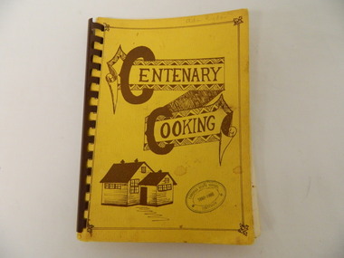
Book - Cooking x2, Centenary Cooking, 1980
The Tawonga School was a weatherboard building built on 8 acres of land catering for children from the surrounding grazing farms to ride their horses to school. It opened on 27th July 1880. The original school building and records were erased by fire in 1900. The Tawonga hall was used until 1910 when 3 acres of land was donated by Frank Cooper. It still operates today (2015) with its numbers having fluctuated over the years with the Kiewa Hydro Electric Scheme, tobacco farming and now tourism. The Tawonga community published a cook book to celebrate the school's centenary.This book may have also been used as a fund raiser.The Tawonga school celebrated its centenary with a cookbook with contributions from the community. This indicates that the school was very proud of reaching its centenary and the community co-operated with each other to develop this book.This book is a good source of the names of people who lived in Tawonga in 1980.Yellow book with brown writing and sketch of school held together with brown hard plastic binding. It has 90 pages of recipes most of which give the contributor's name.Tawonga State School Centenary 1880 - 1980 (stamped on front & back cover) In pencil on front cover: Ada Ryder An advertising for Kelvinator sticker has been stuck on the inside front cover with 18-3-92 written on it & on the inside back cover and 'Energy Rating' sticker.tawonga school. centenary of school. 1880-1980. cooking. food. kiewa valley -
 Eltham District Historical Society Inc
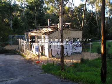
Photograph, Fay Bridge, Warrandyte cool store, 9 September 2019
Remains of the old Warrandyte Dairy — Originally constructed to store milk for delivery from Mapleoak Dairies, delivered by the Bellinger family, up until the early 1970s. The Warrandyte Dairy closed in 1987 before the land and building was purchased by Melbourne Water in 1988 to reduce flood risk to the community and preserve riverside land from development on the site which sits on the Yarra River flood plain. In 2017, through a partnership with Manningham City Council, Warrandyte Historical Society and the Warrandyte Community Association, Melbourne Water renovated the 73-year-old site and installed interpretive signs detailing its history for the community.2019-09-09, fay bridge collection, warrandyte cool store, warrandyte dairy -
 Eltham District Historical Society Inc
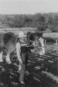
Photograph, Guildo Fabbro, Falkiner Street, Eltham with Clydesdale horse
Guildo Fabbro, Falkiner Street, Eltham with Clydesdale horse with harness in field. The site of the Fabbro farm (Diamond Creek side land) is now called Barrack Bushlands. It is doubtful that Fabbro's farm holding was ever called Barrak Park, This title is fairly recent after the Shire of Eltham purchased the land, including the last section in 1993/94. About this time the area on the west side of Falkiner Street was purchased by a private developer and developed as housing. The area in Bell Street opposite the Eltham High School was purchased by the State Government is recent years and is called Fabbro Fields. The Fabbro Family operated their farm in Bell Street, Eltham. 1 black and white photographfabbro's farm, guido fabbro, bell street, clydesdale horse -
 City of Ballarat
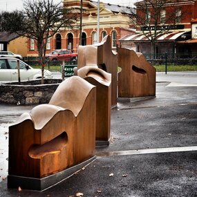
Artwork, other - Public Artwork, Cliff Burtt, Buninyong Bivium, 2016
Buninyong Bivium (2016) by Cliff Burtt engages with the geography and history of the Buninyong region in both pre and post settlement. The town of Buninyong is dominated by the profiles of Mt Helen and the extinct volcano Mt. Buninyong. Traditional land of the Wadawurrung people, today the area remains a significant site for the culture of indigenous people and their connection to the land. The profile of this sculpture is based on topographical mapping of the area, depicting sections of the landscape. The gaps between the elements of the work can be viewed as representations of the shafts sunk into the earth by the early gold miners and compound curves on the upper surfaces are mirroring the topography of the area, while cut-aways in the sides are suggestive of rock strata.The artwork is of aesthetic and social significance to the people of BallaratCorten steel sculpture made of five unique sculptural pieces secured to at concreate base at pavement levelbuninyong, cliff burtt, sculpture, public art, mining, ballarat -
 Mt Dandenong & District Historical Society Inc.
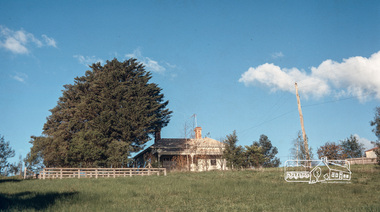
Photograph
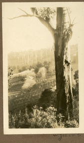
The W. JEEVES in the inscription would be Walter Jeeves. Walter Jeeves was the second son of Ellis Jeeves and the grandson Of Isaac the Pioneer. Walter had been given the house 'Kalorama' and twenty acres of land. He turned this into a commercial garden. Firstly vegetables then later flowers and shrubs. The land was sloping. Walter married Dorothy Hayes and had four daughters. When Walter died in 1960 the property was put up for sale and it was eventually purchased for the State through the efforts of the Save the Dandenongs League. This photograph is from the album of Ivy May Child so would have been taken between 1927 - 1932.Sepia coloured photograh with a tall gum tree in the foreground and a large homestead in the centre of the photograph surrounded by orchards.Written below the photograph in the album: W. JEEVESwalter jeeves, dorothy hayes, save the dandenongs league, kalorama -
 Kew Historical Society Inc
Photograph - Filling in the Outer Circle Railway cutting at East Kew, 1939
W.D. Vaughan (Kew's Civic Century, 1960, pp.195-6) quotes Council Minutes of 1938 and 1939 to record that: "After protracted negotiations between the Council, the Railways Department and the Tramways Board agreement was reached in June, 1938, for the filling of the railway cutting at the Harp Junction and shifting tram tracks to the High Street alignment ... The Outer Circle railway land from Princess Street to Park Crescent was purchased by the Kew Council in October, 1939, for 2,750 [pounds]. The land from Park Crescent to High Street was leased for 1 [pound] per annum. Considerable work was done in levelling the embankments to the original surface level."Important and rare photograph of the period, showing major works by Kew Council in Kew East working on a significant piece of urban infrastructure.Small, original black and white positive (photograph) showing workers and vehicles filling in the tracks of the former Outer Circle railway at East Kew. In the background is the metal bridge with brick piers, adjacent to the Harp Junction. The bridge crossed the cutting, linking the two parts of High Street. Behind the tip truck, painted on the side with the name 'Fowler Quarries' [located Keilor Road, North Essendon], one can see shops [including T.G. Garroway, Cash Grocer] in High Street. What appears to be the City of Kew Steamroller is immediately in front of the bridge. A group of passers-by watch from the bridge and from the road. Annotation in pencil on verso: "Filling in Outer Circle line at High St East Kew prior to straightening High St. (c. Feb 1930?)outer circle railway, railway cuttings, harp junction, high street -- kew east -
 Kew Historical Society Inc
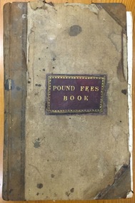
Administrative record (item), Borough of Kew, Pound Fees Book, 1874-1896
While the first successful land sales in Boroondara occurred in Hawthorn in 1843, and Kew in 1845, these areas were to be without local pounds until April 1858, when the Governor of Victoria, in accordance with Act 18 Victoria No 30, was pleased to direct the establishment of a Pound at Glass’s Creek on that part of land bounded by the Kilby Road, Burke Road and High Street. While the Governor was required to proclaim the establishment of a pound, the appointment of a poundkeeper was the responsibility of the Justices of the Peace in the local Court of Petty Sessions. The Pound took its name from the most distinctive natural feature of the area, Glass’s Creek, named after the early pastoralist Thomas Glass.The register is of historic significance as an indicator of suburban life in the second half of the 19th Century. It shows how farming and city life on the urban fringe were intimately connected. It is also significant to the early history of Hawthorn and Kew, who both claimed the Pound following their separation from the Boroondara Roads Board in 1861."Kew Pound Book"glass creek pound (kew), animal pound, dog pound, kew pound, j. smith, john oakes, samuel b. cash, edward s. delaney, emma oswin, samuel cash -
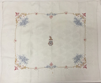 Kew Historical Society Inc
Textile, Damask Tablecloth embroidered with the Greenlaw Crest, 1882-1890
When the newly married William and Anna Maria Greenlaw acquired the property in 1862, an existing house known as Studley Villa stood on the land. John Hodgson probably built the latter soon after he bought three portions of land here in 1853. The Greenlaws changed the name of the residence to Villa Alba in about 1870 and in 1882-84 rebuilt the house to create the present mansion. After William Greenlaw’s death in 1895, John Ballinger rented the house until 1914. The lease then passed to Samuel and Esther Fripp, who went on to purchase the property in 1918 after Anna Maria Greenlaw’s death in 1918.This rare textile is associated with the most significant period of Villa Alba's history and is an example of the colonial aspirations of its citizens in the boom years of the 1880s before the crash that engulfed the owner.Small white damask tablecloth or napkin embroidered with the crest of William Greenlaw, the owner of Villa Alba in Walmer Street, Kew. The embroidery of the crest and borders of garlands are completed in multicoloured silk thread.Greenlaw crest - griffin holding thistle in beak over initials WGvilla alba, william greenlaw, tablecloths -
 Sunbury Family History and Heritage Society Inc.
Photograph, Bulla Primary School, Hanging Rock, 1995
In 1995, the upper school students from Bulla Primary School attended a camp at Hanging Rock Reserve which is part of the Macedon Ranges. At this camp the students were shown basic rock climbing skills and explored the rock for its interesting geological formations. Hanging Rock, also known as Mount Diogenes, is the traditional land of the Dja Dja Wurrung, Woi Wurrung and Taungurung people. It is a mamelon formed when magma poured from a vent and congealed. There are interesting rock functions at the site such as the Colonnade, the Eagle and the UFO. The highest point on the rock is 718metres above sea level and 105 meters above the land at its base.Hanging Rock is an important geological and volcanic structure in the Macedon Ranges area and in central Victoria. A non-digital coloured photograph of three holiday cabins and a barbecue in a bushland setting. A red car is parked outside one of the cabins as well as two permanent picnic tables.hanging rock, mount diogenes, mamelons, volcanoes, school camps, bulla primary school -
 Surrey Hills Historical Society Collection
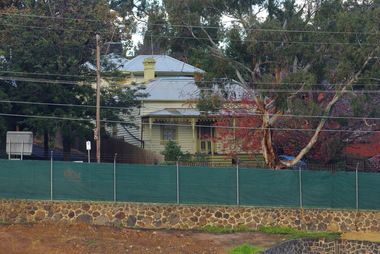
Photograph, 215 Union Road, c 1920
The house was variously known as ‘Mintaro’, ‘Montiere’ and ‘Goonoo Goonoo’, the later after 1920 when it was purchased by Natale Cerini and his wife Ethel May (nee Swan), who were married in 1918. Built 1887-1888 by William Wigley. The original colour was deep cream with dark green trim. Property included a block of land on south side and also land to the north. The original coach house was on what became 213 Union Road and was used to build a yacht in by the then neighbours, the Flemings. The street plane trees were replaced in the 1970s with melaleucas and in 1987 new plane trees were planted between the melaleucas. Sepia copy of an older photo of 215 Union Road from diagonally across the road. Shows street surface, bluestone kerbing, a young tree within a guard and a Victorian style home with 3 chimneys, a slate roof and a veranda on at least the south and west side. Beyond the house are mature cypress and other trees and a spire. The spire belonged to Surrey College, a boys' boarding school (later Nethercourt Hospital and St Judes.)'mintaro', 'montiere', 'goonoo goonoo', william wigley, mrs ethel may cerini, miss ethel may swan, miss jocelyn cerini, mrs jocelyn hall, miss lynette cerini, victorian style, 215 union road -
 Surrey Hills Historical Society Collection
Photograph, St Stephen's Presbyterian Church, Surrey Hills, viewed from Warrigal Road, 1980's
The first service of the Surrey Hills Presbyterian Church was held at ‘Kinnoul’, the home of Thomas Hogg, located in The Avenue. This was while the church was being built. St Stephens Presbyterian Church opened in March 1899 on land that had previously been part of Klepper's orchard. The first minister was Rev F A Darling. He resigned in 1892 to open Surrey College. The church building pictured was built in 1910 adjacent on land gifted to the church. Noted features of the interior are the pulpit and honor board carved by sculptor John Kendrick Blogg. There are also memorial windows to Charles de Burgh Hogg and William Thomas Hogg, both killed in WW1.Red brick church with bell tower and slate roof. Cyprus tree at side; other trees fronting Canterbury Road.Canterbury Road - Warrigal Rd (written in biro on th back of photo)stained glass, lead lights, churches, presbyterian church, st stephens presbyterian church, 1980-1989, surrey hills, canterbury road, warrigal road, john kendrick blogg, charles de burgh hogg, thomas william hogg -
 Glen Eira Historical Society
Document - Hawthorn Road, 377, Caulfield
Valuation report dated 29/11/1965 for 377 Hawthorn Road Caulfield detailing land, improvements and general comments together with marked and rental values. This is a carbon copy with bottom of first page cropped and therefore is missing some lines.hawthorn road, caulfield, land use, factories, bakeries, bricks, rents and renting -
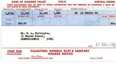 Greensborough Historical Society
Financial record - Account, Shire of Diamond Valley, Shire of Diamond Valley rates notices 1970-1971, 26/03/1958
Shire of Diamond Valley Rates assessment issued to Alan Partington in 1970. This land is assessed as an "Urban Farm". In 1974 the 'farm rate' was declined for this property, eventually leading to its acquisition by the Shire for recreational space, now known as Whatmough Park.Part of the property owned by the Partington family in the original Greensborough farmland. Rates notice, printed in red text with black typed details.Date stamped with rubber stampalan partington, william alan partington, partington family, land deals greensborough, church street greensborough, whatmough park -
 Phillip Island and District Historical Society Inc.
Photograph, 1978/9
Charlie Richardson was the son of William Richardson and grandson of Joseph Richardson who arrived on Phillip Island in 1868. The house at Rhyll was built by William Richardson who went to live at Rhyll in 1876 on land, owned by his father, opposite the Jetty.Coloured photograph showing the Kitchen of Mr Charlie Richardson's home, opposite the Rhyll Jetty.local history, photographs, buildings - historical, housing, coloured photograph, john cook, phillip island, charlie richardson -
 Phillip Island and District Historical Society Inc.
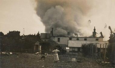
Photograph, Isle of Wight Fire, 1926
Part of a collection from Mrs Jessie Smith. The Isle of Wight Hotel is the most prominent hotel on the Cowes foreshore near right corner of Thompson Avenue, looking north. Burnt down again and now a vacant block of land (as at 2017)Side view of Isle of Wight Hotel with roof in flames. Girl in check dress and hands on hips with dog, middle foreground. Fire 1926.local history, photographs, isle of wight hotel cowes phillip island, sepia photograph, fire, the esplanade cowes, phillip island, jessie smith collection, stan mcfee -
 Greensborough Historical Society
Photograph - Digital Image, Partingtons Flat and Whatmough Park taken from hill, 1930c
The Partington and Whatmough families came to Melbourne in the 1840s and moved to Greensborough where they farmed along the Plenty River. The Partingtons Flat Reserve and Whatmough Park were part of their land holdings and are now Banyule Council owned reserves and sporting fields.Digital copy of black and white photograph.partington family, whatmough family, whatmough park, partingtons flat -
 Geelong RSL Sub Branch
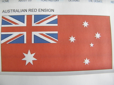
Flag, Early 20th Century
The Australian Red Ensign or The Australian Civil Ensign is for use only at sea and officially never on land, but can be used by private citizens.At sea the flag is used by Merchant Ships registered in Australia. Pleasure craft may fly the Red Ensign.From 1901 to 1954 the Red Ensign was used as Australia's Civil Flag ie flown by private citizens on land. Australian Red Ensign, cloth, oblong, predominantly red, Union Jack in top left hand corner and the stars of the Australian National Flagflag, ensign, red, australia -
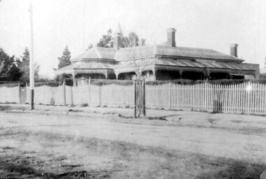
 Eltham District Historical Society Inc
Photograph, Fred Mitchell, Sunnyside, 82 Bible Street, Eltham, 1968, 1968
Original home of W.J. Taylor and family who owned all the land looking west from the house to the Diamond Creek. Hence, Taylor Street. Located on top of the hill, the home was built c.1885 and still stands today (No. 82). Digital copy of colour photographfred mitchell collection, 1968, bible street, eltham, houses, w.j. taylor, sunnyside -
Glen Eira Historical Society
Article - Tonks W.B., Estate Agent
This file contains one document. Photocopy of a newspaper article in the PRAHRAN TELEGRAPH, 15/11/1913 describing Mr W.B. Tonks’ expanding real estate business including his new office locations, land prices and insurance schemestonks w.b., elsternwick, glenhuntly road, e.s.a. banks elsternwick, caulfield, property developers, estate agents, real estate agencies, gardenvale -
 City of Moorabbin Historical Society (Operating the Box Cottage Museum)
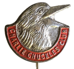
Badge - Charlie Chuckles Club Pin, 1941-1954
Charlie Chuckles, who, in the early 1940s, presented weekly radio dramatisations of Sunday Telegraph comic strips. It was a great favourite with youngsters throughout the land. Charlie Chuckle commenced in 1941 and ran through until 1954. It was a 30 minute program. Silver pin with the head of a kookaburra and a red banner underneath with the words "Charlie Chuckles Club".Charlie Chuckles Clubcharlie chuckles, sunday telegraph, children's show, radio -
 Bayside Gallery - Bayside City Council Art & Heritage Collection
Photograph, Department of Crown Lands and Survey, Victoria, Brighton, Elwood and Elsternwick, c. 1965-71
The Department of Crown Lands and Survey (1857-1983) was responsible for the administration of survey and mapping and the sale, occupation and management of crown land throughout its existence. This aerial photograph shows parts of Brighton, Elwood and Elsternwick and was taken circa 1965-71.brighton, department of crown lands and survey, aerial photograph, bayside, port phillip bay, map, cartographic material, elwood, elsternwick, elsternwick park, elwood tram depot, elwood pier, new street, glen huntly road, st kilda street, nepean highway -
 Bayside Gallery - Bayside City Council Art & Heritage Collection
Photograph, Department of Crown Lands and Survey, Victoria, Brighton, Brighton East and Bentleigh, c. 1965-71
The Department of Crown Lands and Survey (1857-1983) was responsible for the administration of survey and mapping and the sale, occupation and management of crown land throughout its existence. This aerial photograph shows parts of Brighton and Brighton East and was taken circa 1965-71.brighton, department of crown lands and survey, aerial photograph, bayside, port phillip bay, map, cartographic material, brighton east, dendy park, dendy street, centre road, nepean highway, south road, brighton golf course, golf -
 Ringwood and District Historical Society
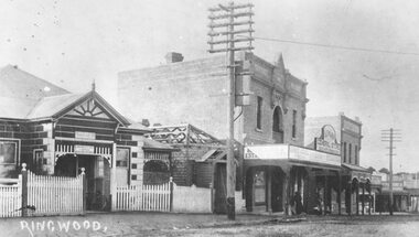
Photograph, Maroondah Highway Central, Ringwood. Ringwood Coffee Palace, 1918
Black and white photograph (2 copies- 1 large, 1 small)Written on rear of backing sheet of large image: "Ringwood Coffee Palace (With Ringwood P.O. on left). Typed on back of small copy: "A.E. Walker arrived in Ringwood in 1910 from Gembrook. Bought land and erected shop. In Oct.1913 he sold out to Capt Miles who had erected Coffee Palace on each side of shop. Then rented shop from Miles. Shop later run by Beilby. -
 Ringwood and District Historical Society
Photograph, Landys home (formerly Patersons). Byways estate area (East Ringwood). 5 Views. (c1968)
SS0261 is the covering letter from Beth Little, dated 31/3/1969, which states: "Please fined enclosed the photographs I took of Landy's 80 yr. old home which was moved just before last Christmas to another site on their estate...it was built by some people by the name of Patterson and originally included the Byways Estate and other land which extended up to about Lillis Crt. The land known as Byways Estate was sold off to a Mr Best by a later owner so far as I can find out.." Written on back of photographs: SS0261a:From about where the feed shed was. SS0261b:Looking up driveway towards the east. Landys home (formerly Patersons). Byways estate area (East Ringwood) SS0261c:Eastern side of house (officially the front). SS0261d:Stable and feed shed now demolished. Wooden tank on right-hand side. SS0261e:Southern side. Well to left of far end of house wall -
 Greensborough Historical Society
Photograph - Digital image, Marilyn Smith, Old Ely House in Greensborough 2010, 03/07/2010
Recent photograph of one of the older houses in Greensborough. This house is in Grimshaw Street Photo taken at the very beginning of the construction of the Watermarc precinct. This house at 49 Grimshaw Street, along with the one next door at 47 Grimshaw Street were built by John Ely, son of Frederick Ely. John and his wife Melinda(Iredale), lived in Main Street (where is father Fred lived), then Grimshaw Street, John a labourer, later an assistant. John owned land in Grimshaw Street, where he built their home, he subdivided the land, this was when Eldale Avenue came to be, a combination of John’s and Melinda’s surnames. He sold a block of land, to Dr. E.R. Cordner, this is where the Cordner house, “Ashmead” was built. John and Melinda’s house later (mid 1970's) became a 'Ely House Medical Centre' owned by Drs. Myerscough and Hugh T McDonald . Alan (John's son) and Maisie’s a Physiotherapy Centre. Later Drs Stephen Hanslow and Dr. Eastern operated the medical centre. The house at 47 Grimshaw Street was demolished in 2017.Digital copy of colour photograph.grimshaw street greensborough -
 Surrey Hills Historical Society Collection
Photograph, Chatham State School Grade 1 1927, 1927
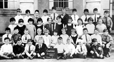
Chatham School, located in Weybridge Street Surrey Hills, was opened on 1 August 1927 following pressure from local residents as nearby schools (Balwyn, Mont Albert & Surrey Hills) were all over-crowded. This followed a surge in development following WW1. Land in surrounding streets was sub-divided. This included part of John Butler Maling (Jnr)'s small farm bounded by Banool Road, Wharton Road, Weybridge Street and Whitehorse Road. An area surrounding his home, 'The Willows' was retained and not sold until after he died in 1931. leased by Mr John Butler Maling in 1861. Three acres of his land were purchased by the Education Department. Some of the early students have referred to Chatham’s land as Mr Maling’s bull paddock. Some of the original yellow box trees remain on the property. The most significant of these is now called the Friendship Tree. On 1 August 1927 212 students were enrolled; Ralph Rae was one of these. The school was official opened on 15th February 1928. The school number is 4314. A black and white photograph of a group of 39 Grade 1 students from Chatham State School.1927, schools, chatham state school, clothing and dress, primary schools, john butler maling (jnr), ralph rae (mr) -
 Surrey Hills Historical Society Collection
Photograph, Chatham State School Grade 5 1931, 1931
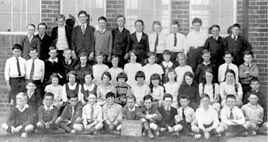
Chatham School, located in Weybridge Street Surrey Hills, was opened on 1 August 1927 following pressure from local residents as nearby schools (Balwyn, Mont Albert & Surrey Hills) were all over-crowded. This followed a surge in development following WW1. Land in surrounding streets was sub-divided. This included part of John Butler Maling (Jnr)'s small farm bounded by Banool Road, Wharton Road, Weybridge Street and Whitehorse Road. An area surrounding his home, 'The Willows' was retained and not sold until after he died in 1931. leased by Mr John Butler Maling in 1861. Three acres of his land were purchased by the Education Department. Some of the early students have referred to Chatham’s land as Mr Maling’s bull paddock. Some of the original yellow box trees remain on the property. The most significant of these is now called the Friendship Tree. On 1 August 1927 212 students were enrolled; Ralph Rae was one of these. The school was official opened on 15th February 1928. The school number is 4314. A black and white photograph of a group of 51 Grade 5 students from Chatham State School.schools, chatham state school, clothing and dress, primary schools, john butler maling (jnr), ralph rae (mr) -
 Orbost & District Historical Society
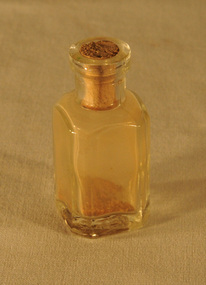
specimen bottle, circa 19th, early 20th century
On loan from John Mundy family. Searching for gold in the Orbost district began in the last half of the 19th century and continued until circa 1930s. The original Mundy family moved to a land "selection" at Betebolong in the early 1880's from Buchan. This item is reflective of the late 19th -early 20th century gold mining era in East Gippsland.A small square bottle with a push-in cork stopper. This bottle contains specks of gold or gold dust. mining-gold