Showing 10531 items
matching land
-
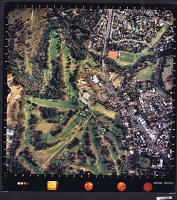
 Heidelberg Golf Club
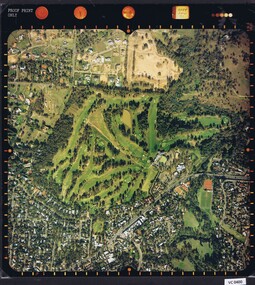
Photograph - Aerial Photograph, Heidelberg Golf Course 2000, 01/05/1980
Aerial photograph of Heidelberg Golf Club course in 1980, showing the course layout and surrounding land use.Aerial photograph, colour.Printed on edge of photo: "Colour proof", "LandSur756"aerial photographs, heidelberg golf club, lower plenty -
 Heidelberg Golf Club
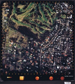
Photograph - Aerial Photograph, Heidelberg Golf Course 2000, 01/05/1980
Aerial photograph of Heidelberg Golf Club course in 1980, showing layout of course and surrounding land use.Aerial photograph, colour.Printed on edge of photo: "Colour proof", "LandSur756"aerial photographs, heidelberg golf club, lower plenty -
 Heidelberg Golf Club
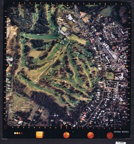
Photograph - Aerial Photograph, Heidelberg Golf Course 2000, 01/05/1980
Aerial photograph of Heidelberg Golf Club course in 1980, showing layout of course and surrounding land use.Aerial photograph, colour.Printed on edge of photo: "Colour proof", "LandSur756"aerial photographs, heidelberg golf club, lower plenty -
 Heidelberg Golf Club
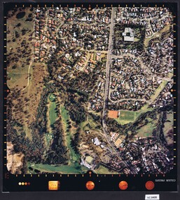
Photograph - Aerial Photograph, Heidelberg Golf Course 2000, 01/05/1980
Aerial photograph of Heidelberg Golf Club course in 1980, showing layout of course and surrounding land use.Aerial photograph, colour.Printed on edge of photo: "Colour proof", "LandSur756"aerial photographs, heidelberg golf club, lower plenty -
 Heidelberg Golf Club
Photograph - Aerial Photograph, Heidelberg Golf Course 2000, 01/05/1980
Aerial photograph of Heidelberg Golf Club course in 1980, showing layout of course and surrounding land use.Aerial photograph, colour.Printed on edge of photo: "Colour proof", "LandSur756"aerial photographs, heidelberg golf club, lower plenty -
 The Beechworth Burke Museum Research Collection
Card (Series) - Index Card, George Tibbits, Cnr Ford and Camp Streets (Ford St), Beechworth, 1976
George Tibbits, University of Melbourne. Faculty of Architecture, Building and Town & Regional PlanningIndex system that support the research for Beechworth : historical reconstruction / [by] George Tibbits ... [et al]Arranged by street names of BeechworthEach index card includes: street name and number of property, image of property, allotment and section number, property owners and dates of ownership, description of the property according to rate records, property floor plan with dimensions.beechworth, george tibbitsbeechworth, george tibbits -
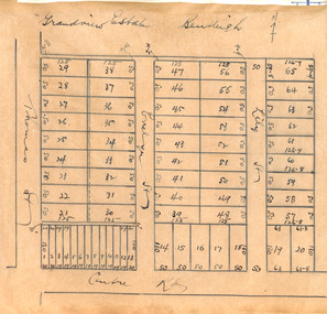 City of Moorabbin Historical Society (Operating the Box Cottage Museum)
Plan - Grandview Estate
The train line from the city to Frankston was electrified in 1922 which intensified the sale in the municipality of Moorabbin, particularly land which was in the vicinity of the railway stations.The train line from the city to Frankston was electrified in 1922 which intensified the sale in the municipality of Moorabbin, particularly land which was in the vicinity of the railway stations. The Grandview Estate was auctioned on Saturday 10 November 1922.Example of the progress of the Municipality of MoorabbinHand drawn map of subdivision Grandview Estate, Bentleighcentre road, evelyn street (now wilson street), lily street, bentleigh, realestate, auction -
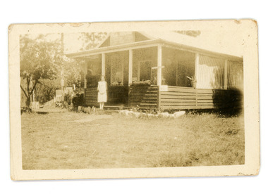 Mt Dandenong & District Historical Society Inc.
Photograph
Jim Keogh owned Lot 7 of the Village Settlement. When the new CRB road went through c1920 his block was cut through leaving a small triangle of land on the high side of the CRB road. He built a shop on this piece of land. The store burned down 31/12/1939. The woman on the step in this photo is Win Woodcock.Sepia image of a woman standing in front of a wooden store. Handwritten inscription on reverse by John Lundy-ClarkeJim Keogh's shop on the north west corner of Falls and Main Roads. Opposite diagonally from St Michael's Church of England. photo Nov 1926.jim keogh, keogh, store, shop, crb road, win woodcock -
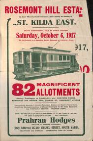 Melbourne Tram Museum
Ephemera - Real estate sale, Prahran Hodges, "Rosemont Hill Estate", Oct. 1917
Pamphlet advertising the sale of land at the "Rosemont Hill Estate", Balaclava Road, St Kilda East, 6-10-1917. On the front cover has a photo of PMTT tram No. 27. Gives terms of sale, the plan of the subdivision, and a general locality plan showing tram and rail lines. Land prices have been written in for some blocks on the pamphlet. Demonstrates the style of land sale pamphlet including the availability of tram services to prospective purchasers.Pamphlet - folded - printed in two colours of cream coloured paper with photographs and plans.has pencil notes re sale price and notes for some blocks.sale of land, trams, real estate, balaclava road, st kilda east, pmtt, tram 27, rosemont hill estate -
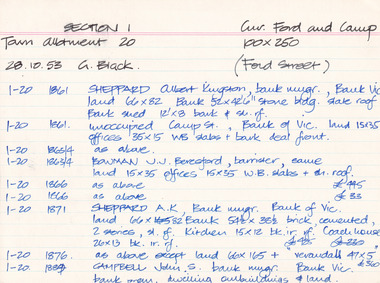
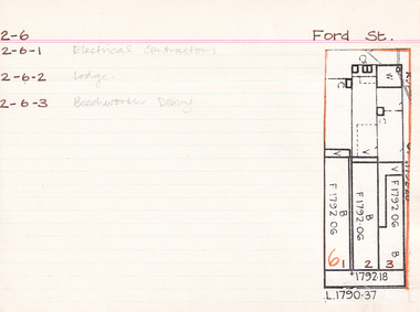 The Beechworth Burke Museum Research Collection
Card - Index Card, George Tibbits, Ford Street, Beechworth, 1976
Property - Ford Street, Beechworth - Section 2, Town Allotment 6 - (Note: also 2-6-1 Electrical Contractors, 2-6-2 Lodge and 2-6-3 Beechworth Dairy) - 100' x250' Ownership details and history - 28 Oct 1853 - W.H. Neuber 1861 - Galbraith, Andrew - Faulkner George, unlisted, J.S. Clark. land 22'x165', shop 32'x20' glass + deal fr. 2 stories, WB + sh. Bakery 25'x20' slabs + bark. Stable 20'x10' WB + do. 1861 - Steel, William, unlisted, J. Manson. land 11'x140' shop 10'x33' plate glass & cedar front, slabs + sh. Back 10'6"x34' WB + sh. 1861 - Joel, Abraham, unlisted, J. Manson, land 11'x140' shop 10'x33' plate glass + cedar front, slabs + sh. bark, 10'6"x34' WB + do. 1861 - J. Manson, unlisted, same, land 22'x25' (in rear) stable 14'x14' slabs + bark 1861 - George Gammon, unlisted, same, land 22'x165' shop 14'x31' glazed front. deal + WB slabs + sh. Kitchen 15'x12' store in rear 20'x10' do + bark 1863/4 - Eveleigh, J.L. (A. Galbraith in '63-'63) J.S. Clark land + prem as 1861. 1863/4 - Hall, Algernon, J. Manson. land + prem as 1861 1863/4 - Faulkner, baker & confectioner, J. Manson, land + prem as 1861 1863/4 - Manson, John as 1861 1863/4 - Gammon as 1861, Kitchen 15'x12' bk. resid. 24'x12' 1866 - Raphael, Julius, Tobias, Sally, tobacconists, J.S. Clark, land 22'x165 shop 20'x38' bk. bldg. glass fr. + sh. rf. Kitch. in rear 14'x12' WB = sh. Do. Stable 20'x10' slabs + bark. £115 1866 - Cunningham, James & Robert, ironmongers, John Manson, land 22'x165' shop 20'x33' plate glass + cedar fr. slabs + sh. rf. prem in rear 21'x34' WB + sh. rf. £110 1866 - Gammon, George, Druggist, same. land 22'x165' prem. 30'x20' + 24'x12' bk. bldg. 2 stories with plate glass + cedar shop front + sh. rf. Kitchen 15'x12' WB + sh. rf. 1871 - Brown, John, Barber etc. J.S. Clark. land + prem as 1866 £75 1871 - Cunningham, J&R, ironmongers, same. land + prem as 1866 + stable 13'x8' slabs + bark £96 1871 - Gammon, G. Druggist, same land + prem as 1866 £144 1876 - Walton, Wm. Tailor, Mary Clark. prem as 1866 exc. kitch 16'x12' + 20'x10' 1876 - Cunningham, J&R, ironmongers, same land 22'x165' prem 20'x30' deal fr. bk walls sh. roof Do. in rear 34'x21. WB + sh. rf. stable 20'x20' WB + ir. rf. £90 1876 - Gammon, George, Chemist, same land + prem as 1866 exc. no. 24'x12' bk £120 1884 - Armstrong, John, Draper, Mary Clark. shop 1884 - Cunningham Js. Ironmonger, same shop 1884 - Gammon, G. Chemist, same, shop + dwelling 1889 - Armstrong, as above £45 1889 - Cunningham, JS. as above. Cunningham, J&R, shop, prem + land £70 1889 - Gammon, G. Chemist, smae shop, dwelling pr. l. £80 1899-1900 - Armstrong. One shop owned, other ....? one 1900-1901 - Armstrong. double shop 1900 - Armstrong, John, draper, same shop + store £110 1900 - Bowen, Wm Johnston, Chemist, Kate Gammon, Sh. DW + L £65 1906 - Armstrong, Draper, same S+L £110 1906 - Bowen, Wm. Johnston, Chemist, Kate Gammon, shop, prem + land £65 Sect. 2, Town Allot. 6 - Note: 2-6-1 Electrical Contractors, 2-6-2 Lodge and 2-6-3 Beechworth Dairy Architectural Index Card - Brian Pump and Tony Dugan - Photographers beechworth, george tibbits -
 Kew Historical Society Inc
Photograph - Willsmere [Kew] Billabong, 1993
Willsmere Park is bounded by the the Yarra River, Green Acres Golf Club, Willow Grove and the Eastern Freeway. The land on which the park is now situated was bought by Thomas Wills at the Crown Land Sales of 1846 (Section 56). From the 1840s to the 1940s it was intensively farmed. The park is dominated by very large playing fields, while planting to the southern boundary was undertaken when the Eastern Freeway was built. It is only along the banks of the Yarra that there is any remnant native vegetation. Willsmere Park is of significance as an area of open land that remains from the flood plain that once dominated northern Kew. (Source: Kew Conservation Study, 1988)Original colour small format polaroid photograph of the 'Kew Billabong' in the Willsmere Park, taken on 16 September 1993."Willsmere Billabong 16.9.93"kew billabong, willsmere park, yarra river -- billabongs -
 Kew Historical Society Inc
Photograph - Yarra River in flood at the Willsmere Park, 1993
Willsmere Park is bounded by the the Yarra River, Green Acres Golf Club, Willow Grove and the Eastern Freeway. The land on which the park is now situated was bought by Thomas Wills at the Crown Land Sales of 1846 (Section 56). From the 1840s to the 1940s it was intensively farmed. The park is dominated by very large playing fields, while planting to the southern boundary was undertaken when the Eastern Freeway was built. It is only along the banks of the Yarra that there is any remnant native vegetation. Willsmere Park is of significance as an area of open land that remains from the flood plain that once dominated northern Kew. (Source: Kew Conservation Study, 1988)Original colour small format polaroid photograph of the Yarra River in flood at the Willsmere Park, taken on 16 September 1993."Yarra River at Willsmere Park Flooding 16.9.93"willsmere park, yarra river -- floods -- kew (vic.) -
 Kew Historical Society Inc
Photograph - Flooding in the Willsmere Park, 1993
Willsmere Park is bounded by the the Yarra River, Green Acres Golf Club, Willow Grove and the Eastern Freeway. The land on which the park is now situated was bought by Thomas Wills at the Crown Land Sales of 1846 (Section 56). From the 1840s to the 1940s it was intensively farmed. The park is dominated by very large playing fields, while planting to the southern boundary was undertaken when the Eastern Freeway was built. It is only along the banks of the Yarra that there is any remnant native vegetation. Willsmere Park is of significance as an area of open land that remains from the flood plain that once dominated northern Kew. (Source: Kew Conservation Study, 1988)Original colour small format polaroid photograph of flooding in the Willsmere Park, taken on 16 September 1993."Flooding of shared path from Willsmere Billabong 16.9.93"willsmere park, yarra river -- floods -- kew (vic.), kew billabong -
 Kew Historical Society Inc
Photograph - Flooding in the Willsmere Park, 1993
Willsmere Park is bounded by the the Yarra River, Green Acres Golf Club, Willow Grove and the Eastern Freeway. The land on which the park is now situated was bought by Thomas Wills at the Crown Land Sales of 1846 (Section 56). From the 1840s to the 1940s it was intensively farmed. The park is dominated by very large playing fields, while planting to the southern boundary was undertaken when the Eastern Freeway was built. It is only along the banks of the Yarra that there is any remnant native vegetation. Willsmere Park is of significance as an area of open land that remains from the flood plain that once dominated northern Kew. (Source: Kew Conservation Study, 1988)Original colour small format polaroid photograph of flooding in the Willsmere Park, taken on 16 September 1993."Flooding of Willsmere Park from Yarra 16.9.93"willsmere park, yarra river -- floods -- kew (vic.) -
 Kew Historical Society Inc
Photograph - Flooding of Willsmere Park from Yarra, 1993
Willsmere Park is bounded by the the Yarra River, Green Acres Golf Club, Willow Grove and the Eastern Freeway. The land on which the park is now situated was bought by Thomas Wills at the Crown Land Sales of 1846 (Section 56). From the 1840s to the 1940s it was intensively farmed. The park is dominated by very large playing fields, while planting to the southern boundary was undertaken when the Eastern Freeway was built. It is only along the banks of the Yarra that there is any remnant native vegetation. Willsmere Park is of significance as an area of open land that remains from the flood plain that once dominated northern Kew. (Source: Kew Conservation Study, 1988)Original colour small format polaroid photograph of flooding in Willsmere Park resulting from heavy rain on 15 September 1993."Flooding of Willsmere Park from Yarra 16.9.93"yarra river -- floods -- kew (vic.), willsmere park -
 Kew Historical Society Inc
Photograph - Willsmere [Kew] Billabong, 1993
Willsmere Park is bounded by the the Yarra River, Green Acres Golf Club, Willow Grove and the Eastern Freeway. The land on which the park is now situated was bought by Thomas Wills at the Crown Land Sales of 1846 (Section 56). From the 1840s to the 1940s it was intensively farmed. The park is dominated by very large playing fields, while planting to the southern boundary was undertaken when the Eastern Freeway was built. It is only along the banks of the Yarra that there is any remnant native vegetation. Willsmere Park is of significance as an area of open land that remains from the flood plain that once dominated northern Kew. (Source: Kew Conservation Study, 1988)Original colour small format polaroid photograph of Willsmere [Kew] Billabong on September 1993."Willsmere Billabong 16.9.93"yarra river -- floods -- kew (vic.), willsmere park -
 City of Kingston
Map - Parish of Moorabbin
Warning: This object includes historical language referring to First Nations Peoples which is no longer appropriate but has been recorded for historical purposes. Produced in 1853, this map shows the land holdings of European families. While the majority of holdings are small there are also large land holdings as can be seen with Henry Dendy's Special Survey. Of particular note is the "Reserve for Aborigines" which was established in approximately 1841 and consisted of over 830 acres. This area is the current location of Mordialloc township and Attenborough Park, in Mordialloc, is the last remnant of the reserve. An Alfred Sikes, possibly the surveyor/cartographer who drew this parish plan, purchased land in Berwick in 1854.A handrawn map on fabric, with blue markings representing the coastline to Port Phillip Bay, red markings representing a proposed train line to Mordialloc, major roads and street, as well as a "Reserve for Aborigines", which constituted approximately 830 acres. In the bottom right hand corner, the map has been signed and dated.Handwritten in ink: Alfred Sikes / 38 Collins St East / June. 1853moorabbin, mordialloc, dendy, port phillip bay, aboriginal reserve, attenborough park -
 Eltham District Historical Society Inc
Negative - Photograph, J.A. McDonald, Fordhams Road, Eltham, 24 July 1962
Culvert discharging towards land owned by Holloway & Spicer about 3pm on 24 July 1962 Heavy rainRecord of various Shire of Eltham infrastructure works undertaken during the period of 1952-1962 involving bridge and road reconstruction projects, sometimes with Eltham Shire Council Project Reference numbers quoted. It was during this period that a number of significant improvements were made to roads and new bridges constructed within the shire that remain in place as of present day (2022). In many situations, the photos provide a tangible visible record of infrastructure that existed throughout the early days of the Shire. The album was put together by or under the direction of the Shire Engineer, J.A. McDonald.1962-07-24, culvert, eltham, fordhams road, infrastructure, shire of eltham -
 Glen Eira Historical Society
Document - Lyall Family
Handwritten document on William Lyall’s grants of land, from rate books dated 1857 to 1872, unsigned and undated.lyall william, caulfield, elsternwick, frogmore, koornang, stables, timber houses, brick and timber houses -
 Greensborough Historical Society
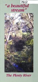
Pamphlet, Friends of the Plenty River, "a beautiful stream": The Plenty River, 2004_04
A publicity pamphlet for "Friends of the Plenty River", a group formed in 1995 to help rehabilitate the Plenty River and adjacent land.2 p., illus., map. Tri-fold pamphlet.plenty river, lower plenty, friends of the plenty river -
 Greensborough Historical Society
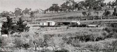
Photograph - Digital Image, Greensborough Station, early 1900s, 1910_
Greensborough Station pre-World War I. The orchard on the land in the foreground is now Poulter Avenue and Pope Place.Shows the rural nature of the Greensborough area in the early 20th centuryDigital copy of black and white photograph. trains, greensborough railway station, poulter avenue greensborough, pope place greensborough -
Greensborough Historical Society
Newspaper clipping, 17 Watsonia home sites sell for 1585 [pounds] average, 1950c
A scrap of newspaper with land prices in Watsonia's "Hillboro" estate. Prices are pre-decimal currency, estimated mid 1950s.AN indication of land prices in the 1950s.Torn clippingwatsonia -
![Document, Town Planning Appeals Tribunal, Town Planning Appeals Tribunal report 1978 [Loyola College], 06/11/1978](/media/collectors/4f729f5697f83e03086015b8/items/58bbb237d0cdef1bcc864955/item-media/58bbb35fd0cdef1bcc8683be/item-fit-380x285.jpg) Greensborough Historical Society
Greensborough Historical SocietyDocument, Town Planning Appeals Tribunal, Town Planning Appeals Tribunal report 1978 [Loyola College], 06/11/1978
Report on an appeal against two conditions on the development of land in Grimshaw Street Watsonia for a secondary school [Loyola College].This document demonstrates some of the problems associated with setting up a school in a residential area.3 pages, torn and yellowed.loyola college -
 Greensborough Historical Society
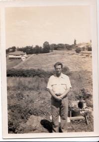
Photograph - Digital image, John Gibson et al, Keith Luxford in Main Street backyard 1950, 1950_01
Keith Luxford in backyard in January 1950, Grimshaw Street behind; and at left; a new horse on Mr Starling's land.Digital copy of black and white photograph. luxford family, grimshaw street greensborough -
 Friends of the Cerberus Inc
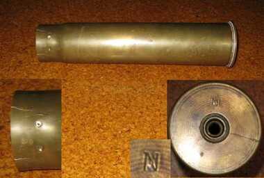
6 pounder Shell casing, 1889
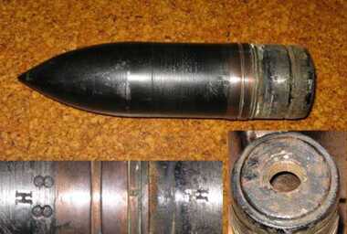
Nordenfelt Six pounder quick firing guns were used by land and naval forces to counter torpedo boats.The projectile and its shell casing are of the type and age used by the Victorian Naval Forces but could equally have been used by the land forces.Cylindrical brass tube closed at base and open at other end.victorian naval forces, victorian navy, nordenfelt quich firing gun, ammunition -
 Friends of the Cerberus Inc
6 pounder Common Shell, 1888
Nordenfelt Six pounder quick firing guns were used by land and naval forces to counter torpedo boats.The projectile and its shell casing are of the type and age used by the Victorian Naval Forces but could equally have been used by the land forces.Cylindrical steel shell with cone shaped nose.On side - "H/88"common shell, hotchkiss, 6 pounder, ammunition -
 Warrnambool and District Historical Society Inc.
Map - City of Warrnambool Freehold and Managed Crown Land, City of Warrnambool Council, 14th April 1994
This map was drawn up by the City of Warrnambool Council staff to provide information on the land in Warrnambool that was owned or managed by the Council.This map is of considerable importance as it gives information in map form of the Warrnambool land that is owned (freehold) by the City of Warrnambool and the land that is managed Crown land. This is of interest to researchers and those seeking information on specific areas of land in Warrnambool.This map has digital mapping. The map has a white background with black and white mapping details of Warrnambool. It has the City of Warrnambool seal. Scale of map: 1:7500warrnambool city council, warrnambool -
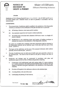 Eltham District Historical Society Inc
Document, Notice of Decision to Grant a Permit; Ref: E94/306 - Subdivision of 30-34 Diosma Road; 16 November 1994, 16/11/1994
This permit was eventually overturned following community objection and the land was donated by Yarra Valley Water for use as a community reserve.The Stokes Orchard Estate collection is typical of housing developments of the late 1970s and 1980s. It was one of the earliest estates in Eltham following the nearby Woodridge Estate development.A4 document consisting of ten pagesAs notedstokes place, eltham, stokes orchard, stokes orchard estate, streets, houses, peter and carla vermey, diosma road, letter of objection, melbourne metropolitan board of works, planning application, reservoir, shire of eltham -
Ringwood and District Historical Society
Book - Eureka Plan, Farmer, Mr, Eureka Plan, c. 1930
Created to assist in promotion and sale of land near Ringwood Railway station, following completion of the electric rail to Ringwood..Book containing details of seven delightful and valuable Ringwood properties - Bestpart, Paradur, Hill Top, Greenwood, Creek, Station and School estates. The book has 16 photos and 20 plans and 20 pages. There are multiple copies of pages 20x2; 19x2; 18x4; 17x4 and 20x2. +Additional Keywords: Farmer, Mr