Showing 5242 items matching "28"
-
 Melbourne Legacy
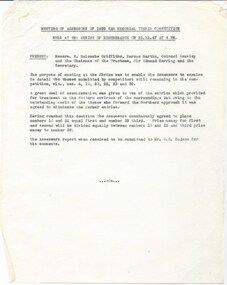
Document, Meeting of the Assessors of 1939 War Memorial Thesis Competition held at the Shrine of Remembrance on 23.12.47 at 4 pm, 1947
After the second world war there was a decision made to create a memorial for the 1939-45 War at the Shrine. A competition was held and 53 entries assessed. The first prize was shared between two submissions and the third prize money was also awarded. These two documents show that Legatee Kemsley was one of the Assessors who decided the basis of design for the memorial. The notes of a meeting of the Assessors show that Mr W. Balcombe Griffiths, Mr Marcus Martin, Colonel Kemsley and Sir Edmund Herring (Chairman of the Shrine Trustees) were present when the winning design was chosen. The design was later completed as the Forecourt in the shape of a paved cross, built in 1953, and the Cenotaph surmounted by a statuary group and the Eternal Flame. The memorial was dedicated and the flame set alight by Her Majesty Queen Elizabeth II on February 28 1954.A record of the decisions made by the committee that chose the design of the memorial for the 1939-45 war that was built as the Forecourt, the Cenotaph and the Eternal Flame at the Shrine of Remembrance. Legatee Kemsley was on the committee. White quarto paper with black type x 3 pages, two pages are a report to the Shrine Trustees on the competition for the design of the 1939 War Memorial and the third page is notes on a meeting of the Assessors of the competition.01187.2-3 Handwritten in pencil 'Shrine'. Title is: "Report of Assessors appointed to examine and award prizes from theses received in connection with the 1939 War Memorial Competition Conducted by the Shrine of Remembrance Trustees"memorial, cenotaph -
 Melbourne Tram Museum
Functional object - Destination Roll, Melbourne & Metropolitan Tramways Board (MMTB), "Footscray Depot", 1940's
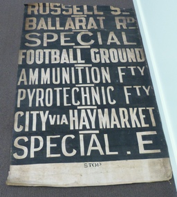
Destination roll used at the MMTB Footscray depot. Has stencil words "STOP" on bottom, stencilled miniature destinations on rear to assist drivers to locate the destination. Roll has a short unpainted section at the bottom. Destinations in order from top are: ; RUSSELL ST; BALLARAT RD; SPECIAL; FOOTBALL GROUND; AMMUNITION FACTORY; PYROTECHNIC FACTORY; CITY VIA HAYMARKET; SPECIAL E. The roll is missing a top section, possibly (based on a Footscray roll held in the BTM Archives), DEPOT; WILLIAMSTOWN RD; RAILWAY STATION, SPECIAL E - for the Explosives Factory. Through running to City from May 1954 when track extended and connected to main system. Image 3 - Photo of Bob Wilson standing alongside taken 27/7/14 by Warren Doubleday, added 28/7/14.Demonstrates a tram destination roll used at Footscray Depotl. Destination roll - white lettering on black background. trams, tramways, mmtb, destination roll, footscray depot -
 Mission to Seafarers Victoria
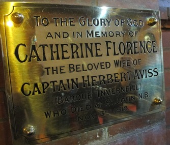
Plaque - Memorial Plaque, Catherine Florence Aviss, 1919
Links to another image in the collection previously unidentified now known as at 2018 to be the children of a seafaring family of Captain and Mrs Aviss. In 1918 the family was re-united with Mrs Aviss' parents after a dangerous journey by sea the first time that the children met their grandparents, Captain and Mrs Frampton also seafarers . Mrs Aviss gave birth to her third child in August 1918 on board the ship. She contracted the "Spanish flu" probably in St John, New Brunswick and died, at the age of 28, on the 3 November 1918 after a week in hospital, leaving her husband with two toddlers and a 3 month old baby. The story demonstrates the respect and support of the Mission for two remarkable families of seafarers and the dangers of the influenza epidemic post WW1.An example of lives and tribulations of a seafarer family who survived the Great War but who also had to deal with the Spanish flu pandemic of 1918-1919.Large engraved brass plaque mounted onto brick wall commemorating wife of sea captain. To the Glory of God / and in memory of Catherine Florence/ the beloved wife of Captain Herbert Aviss/ (Barque Inverneill) who died at St John. N.B./ Nov 3rd 1918.brass, plaque, great war, memorial, commemorate, catherine florence aviss, florence catherine nee frampton, wwi, first world war, barque, inverneill, herbert aviss, st peter the mariner chapel, mission to seafarers, flinders street, 1919, st john, new brunswick, influenza, spanish flu, pandemic, 1918 -
 Wangaratta RSL Sub Branch
Print - Framed Print
HMAS Vengeance was a Colossus class aircraft carrier. Following a three month refit in Sydney, Vengeance (I) commenced seagoing service with the Australian fleet in June 1953, working up in preparation for a deployment to Korea. At the end of July it was announced that HMAS Sydney (III) would deploy to Korea in lieu of Vengeance. In July 1954 Vengeance (I) commenced service as a fleet training ship, including instruction for National Service Trainees. On 27 October 1954 she sailed from Sydney for Japan to embark aircraft, men and equipment of No.77 Squadron, Royal Australian Air Force, and return them to Australia. Vengeance (I) decommissioned on 25 October 1955 and reverted to the Royal Navy. HMAS Melbourne (II) was commissioned three days later on 28 October 1955.Green coloured frame with cream mount containing black and white image of a ship with aircraft on deck at ship’s bow and stern.Vengeance - word formed on deck by ships crew.vengeance, ran, aircraft carrier -
 Bendigo Military Museum
Award - MEDAL SET WW1, Post 1919
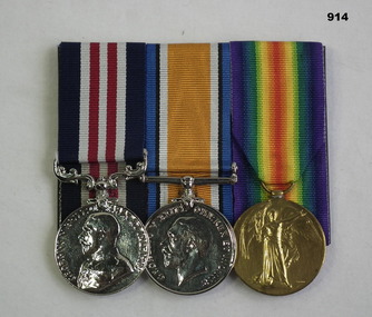
Leslie Pryde enlisted in the AIF 2.8.15 in Divisional Ammunition Column 1 reinforcement 14 age 28 years. Embarked for Egypt 28.1.1916, transfers to 13th FAB 16.4.1916, embarks for France 16.6.1916, promoted to Cpl 7.6.1917, hospital with Trench Fever 12.12.1917, return to unit 30.12.1917, promoted to Sgt 26.1.1918, discharged from the AIF on 7.4.1919. Leslie Pryde was awarded the Military Medal on 15.10.1917 East of Westhoek serving in the 49th Battery. The citation is quite long but the main part is the following; During heavy shelling one of their ammunition dumps was hit and caught fire, Pryde and another NCO at great risk pulled rounds away from the fire area likely to explode and extinguished the fire saving 600 out of 1000 rounds, 400 had exploded.Medal set, court mounted, set of (3) re L Pryde. 1 Military medal, replica not engraved. 2 War medal 1914-1918, replica not engraved. 3 Victory Medal 1914 - 19 3. "11986 Sgt L.Pryde. 1 D.A.C A.I.F" medals, military, bravery, history -
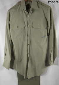 Bendigo Military Museum
Uniform - POLYESTER UNIFORM, ARMY, Australian Defence Industries
1. Shirt - khaki colour, polyester/cotton fabric, long sleeves with button cuffs, shoulder and epaulettes, two front pockets with button down flap, brown plastic buttons. Manufacturers labels have been removed. 2. Trousers - khaki colour polyester/cotton fabric, fob pocket, two side pockets, one back pocket with button down flap, metal zipper fly, khaki colour plastic buttons. Polyester fabric waistband and pockets. Three cotton fabric manufacturers labels, two back inside waistband, one back pocket lining. Black print information.2. Cotton label information, black ink print. Back right inside waistband "REGIMENTAL NO./ NAME". Back left inside waistband "DRY CLEAN ONLY/PRESS ON ORIGINAL CREASES. USE/ DAMP CLOTH OR MEDIUM TO HOT/ STEAM IRON/ MENDING PATCH ATTACHED". Back pocket lining 'WHITMONT/ N.S.W. ^ 1969/SIZE 33 S/W33 1L 28 1/2/ 8405-66-018-5536.uniform, army, polyesters -
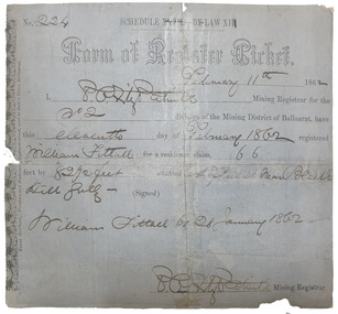 Old Colonists' Association of Ballarat Inc.
Document, Form of Register Ticket made out to William Fittall, 1862
Small ticket stub for a Form of Register TicketForm of Register Ticket No. 224 Schedule XXVII By Law XIII February 11th 1862 I, P.P.FitzPatrick Mining Registrar for the No 2 division of the Mining District of Ballaarat, have this eleventh day pf February 1862 registered Willia Fittall for a residence claim, 66 feet by 82 1/2 feet situated east of Peel Steeet near Black Hill Gully (signed) William Fittall on 28 January 1862sailor, immigration, thomas paterson, greenock, george dempster, chevalier -
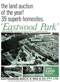 Ringwood and District Historical Society
Document - Folder, Eastwood Park Subdivision, Ringwood East, Vic. - Land Sale Circa 1967 - Site of former Eastwood/Eastfield Golf Course
Subdivision is advertised as including homesites on former Eastwood Golf Course fairways and land contours.Collection of subdivision maps, and double-sided advertisement for auction sale on Saturday, April 22nd, 1967, with summary of local features and services. Subdivision includes Croydon South streets, Andrew Crescent and Banksia Court. Agents - N.R. Reid & Co Pty Ltd, 173 Coleman Parade, Glen Waverley, Tel. 560 0355 A.H. 232 8423.Handwritten sales notations include "Vendor - Willcroft Development P/L 54-60 Southern Road Mentone Tel 93-1267 (Mrs. Morley). Lot 19 $5200, Lot 25 $4500, Lot 28 $3800, Lot 29 $3700, Lot 30 $3600. $400 deposit balance 3 yrs @ 7% $40 per month. All C/S to be prepared by vendor. 5% discount for cash." -
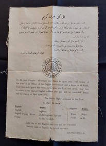 Mont De Lancey
Document - British High Command in the East - Notice, English Government, early 1940's
Arabic text with English translation. This document was given to all Air Crews in WW11 in case of a crash in Arab lands.A rare British High Command in the East "blood chit" or message issued for use by British aviators in the North African campaign for Arabic citizens coming across an English Officer of the English Government and a friend to all Arabs, advising all to treat him well and help him to return to the nearest English soldiers. A prayer completes the notice. There is a list of a few Useful Words in English and Arabic at the bottom of the sheet. The sheet is backed on linen.At the top of the notice there is Arabic script, and printed inside a circle in the centre of the page is the English Government symbol of a lion and a unicorn holding a shield with a crown on the top. There is Arabic script inside the circle too. On the back of the fabric glued to the paper are some grey pencil markings: 282 T Cite 32 25 W 36. 28 E Baltr 395 15 c These are all indescipherable numbers and letters. 22Ukb 2Cww11, world war 2, second world war, war documents -
 Flagstaff Hill Maritime Museum and Village
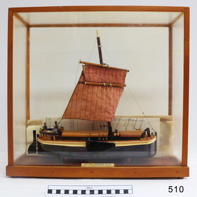
Craft - Ship model, 28-01-1985
This unnamed ship model was built by a Warrnambool resident. The Humber Keel design is typical sailing craft used for transport if inshore and inland cargo, from Humber and Hill, around Yorkshire, U.K. in late 19th and early 20th century. Ship model, single mast, double spar, humber keel. Two tone brown and cream paint, light brown sail. Figures of a man, woman and dog on deck. A type of vessel used on the Yorkshire waterways. Perspex case with wooden frame. Folded plans are inside case. Nameplate Plaque inside case describes ship."RIVER HUMBER KEEL/YORKSHIRE/LENGTH 61', BEAM 15'6", DR G CAP 100 TONS/CREW MAN & WIFE, SCALE 1:40/HUON PINE etc. E.H. GRANGER 28.1.1985" on plaque inside caseflagstaff hill, warrnambool, shipwrecked-coast, flagstaff-hill, flagstaff-hill-maritime-museum, maritime-museum, shipwreck-coast, flagstaff-hill-maritime-village, humber keel, sailing cargo -
 Ringwood and District Historical Society
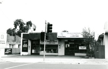
Photograph, Wantirna Road Shops, Ringwood, Victoria - 1993, 28-Feb-93
Black and white photograph of group of shops in Wantirna Road Ringwood including McPhail Hardware and Wantirna TV and Video Service. -
Ringwood and District Historical Society
Certificate, Red Cross Association, Ringwood Red Cross record cards, 1941, 28-Nov-41
Certificate awarded to Mrs. Klix for attending First Aid lectures and demonstrations by the Australian Red Cross.Pale buff coloured cards with black printing and Red Cross emblem +Additional Keywords: Klix, Mrs. -
Ringwood and District Historical Society
Letter, Letter and Envelope Mr Grant, Blacksmith, Ringwood 1906 (Photocopy), 28-Aug-06
Letter to Mr Grant in receipt of a cheque from him to William Thompson for 100 Logan plants @ 10/-. Dated 30.Aug.1906. Envelope addressed to Mr J. Grant, Blacksmith, Ringwood.Photocopy of note to Mr Grant from William Thompson and photocopy of envelope. +Additional Keywords: Grant, J. / Thompson, Wm -
 Bendigo Military Museum
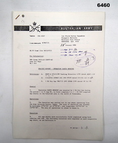
Administrative record - 1 Fd Svy Sqn Project Report - Operation Carto Mercury 1986, 28 Jan 1986
Operation Carto Mercury was a field completion Operation mounted by 1 Fd Svy Sqn 11 Aug 1985 to field complete 4 x 1:25000 compiled map sheet in the Cabarlah area to the North of Tawoomba. Included maps: 9243 - 23 Kingsthorpe, 9243 -24 Goombungee, 9243 - 21 Gomaren Creek, 9243 - 22 High FieldsA4 Typed document and diagrams, 14 pages. Report produced by 1 Fd Svy Sqn 1986royal australian survey corps, rasvy, fortuna, army survey regiment, army svy regt, asr, 1 fd svy sqn -
 Bendigo Military Museum
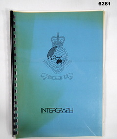
Administrative record - Intergraph Maintenance Programme for Project "Newhart", Intergraph, Suite 6, 1401 Burke Rd, Kew East 3102, 28 August 1992
Intergraph Maintenance by Replacement Proposal (MBR) is the Terms and conditions for the implementation of "Project Newhart" ad the ongoing maintenance of the Automap 2 System. The Document was prepared by Intergraph's Account Manager, Norman John McMurtrie and addressed to LtCol R McHenry, CO Army Survey Regiment.A4 Booklet, Plastic cover, Blue front cover and white rear, Plastic ring binder, RASvy Badge and Text "Intergraph". Pages inserted loose and not secured, includes diagrams and text.royal australian survey corps, rasvy, fortuna, army survey regiment, army svy regt, asr -
 Eltham District Historical Society Inc
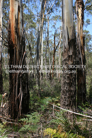
Photograph - Digital Photograph, Alan King, Manna Gums at the Gawa Wurundjeri Aboriginal Resource Trail, 28 December 2007
Manna Gum is a species of a small to a very tall tree that is endemic to south-eastern Australia. These particular trees are part of the Gawa Wurundjeri Resource Trail at Watsons Creek. Signs share information about how the Wurundjeri people lived near the creek and used the land to obtain bush foods, medicines, tools, shelter and clothes. The trail introduces visitors to the indigenous flora and fauna, including manna gums, Lomandra (used to weave baskets) and wombat burrows. Published: Nillumbik Now and Then / Marguerite Marshall 2008; photographs Alan King with Marguerite Marshall.; p3This collection of almost 130 photos about places and people within the Shire of Nillumbik, an urban and rural municipality in Melbourne's north, contributes to an understanding of the history of the Shire. Published in 2008 immediately prior to the Black Saturday bushfires of February 7, 2009, it documents sites that were impacted, and in some cases destroyed by the fires. It includes photographs taken especially for the publication, creating a unique time capsule representing the Shire in the early 21st century. It remains the most recent comprehenesive publication devoted to the Shire's history connecting local residents to the past. nillumbik now and then (marshall-king) collection, gawa wurundjeri aboriginal resource trail, manna gums, watsons creek -
 Eltham District Historical Society Inc
Photograph - Digital Photograph, Alan King, Original Kangaroo Ground Primary School No. 2105 building, Eltham-Yarra Glen Road, Kangaroo Ground, 28 December 2007
Kangaroo Ground's first school began in 1851 with 22 pupils from the district's ten families. It was a single room school located further south on the site, which also served as a Presbyterian church. The first teacher was Andrew Ross. The school building was used as a Post Office between 1854 and 1858 and during 1857 also served as a Court of Petty Sessions. With a growing farming community, a new building was warranted and the original Sate School No. 352 was closed and a new building, State School No. 2105 was oipened October 1, 1878. A residence for Head Teacher Henry Wallace School was erected in 1879 attached to the left of the school building. That residence is now home to the Andrew Ross Museum, which opened in 1993. Covered under Heritage Overlay, Nillumbik Planning Scheme. Published: Nillumbik Now and Then / Marguerite Marshall 2008; photographs Alan King with Marguerite Marshall.; p35This collection of almost 130 photos about places and people within the Shire of Nillumbik, an urban and rural municipality in Melbourne's north, contributes to an understanding of the history of the Shire. Published in 2008 immediately prior to the Black Saturday bushfires of February 7, 2009, it documents sites that were impacted, and in some cases destroyed by the fires. It includes photographs taken especially for the publication, creating a unique time capsule representing the Shire in the early 21st century. It remains the most recent comprehenesive publication devoted to the Shire's history connecting local residents to the past. nillumbik now and then (marshall-king) collection, kangaroo ground, eltham-yarra glen road, kangaroo ground primary school no. 2105, kangaroo ground state school, state school no. 2105 -
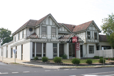 Eltham District Historical Society Inc
Photograph - Digital Photograph, Alan King, Eltham Hotel, cnr Main Road and Pitt Street, 28 December 2007
The Eltham Hotel is the oldest continually operating hotel in the Eltham district. Initially referred to as the Little Eltham Hotel, it has been known as the Eltham Hotel since the mid-1850s through to the present except for a brief period as the Eltham Tavern in the late 1980s. The original hotel opened in 1854 by Richard Warren was built by Benjamin Oliver Wallis. The Fountain of Friendship Hotel on the opposite side of Maria Street (Main Road) opened shortly after. The hotel was a well-known resting place for gold diggers during the gold rush at Woods’ Point and Warren would buy the gold from the diggers. Warren ran into financial difficulties and determined to return to England. Wallis bought the hotel in 1861 and ran it till 1886 when he sold it to Christopher Watson Snr. When Christopher Watson Snr died a year after purchase, his son Christopher took over until his death in 1909 when it passed to wife Emily and then their youngest son, Herbert James (Jim) Watson in 1915. In July 1925, Jim Watson demolished the original building and, in its place, erected a modern hotel which remains the foundation of the present-day Eltham Hotel. Covered under Heritage Overlay, Nillumbik Planning Scheme. Published: Nillumbik Now and Then / Marguerite Marshall 2008; photographs Alan King with Marguerite Marshall.; p41This collection of almost 130 photos about places and people within the Shire of Nillumbik, an urban and rural municipality in Melbourne's north, contributes to an understanding of the history of the Shire. Published in 2008 immediately prior to the Black Saturday bushfires of February 7, 2009, it documents sites that were impacted, and in some cases destroyed by the fires. It includes photographs taken especially for the publication, creating a unique time capsule representing the Shire in the early 21st century. It remains the most recent comprehenesive publication devoted to the Shire's history connecting local residents to the past. nillumbik now and then (marshall-king) collection, eltham, eltham hotel, main road, pitt street -
 Eltham District Historical Society Inc
Photograph - Digital Photograph, Alan King, Former Police Residence, 728 Main Road, Eltham, 28 December 2007
The institutions of law and order in Colonial Victoria included the police, courts and prisons. The 1852 report of the Snodgrass Select Committee appointed to "identify the policing needs of the colony” noted there existed seven independent police forces that did not co-operate or regularly communicate. Following the committee's report all these police entities were merged into the Victoria Police, founded on 8 January 1853, to implement law and order responsibilities throughout the Colony of Victoria. The Eltham Courthouse (1860) and adjacent Police Residence (1859) formed a justice precinct established in the immediate aftermath of the 1852 police inquiry and the effects of the gold rush. The physical presence of these buildings, in the centre of the early Eltham township, defined centralised control over law and order. In the early days the Police Constable in charge would conduct his duties travelling around the district by horse; a stable was located at the rear of the residence. At times the horse would be grazed on the paddocks across the road. Horseshoes were forged by the blacksmith beside the Courthouse on the high side of “Policeman’s Hill”. Along with the stable, there was a two-cell bluestone lockup where prisoners were held awaiting trial in the adjacent Courthouse. Their meals were usually provided by the policeman’s wife or from the hotel just up the road. With the arrival of the railway in 1902 the town centre gradually shifted towards the railway station. The Police Station and operations were moved into the town centre in 1961 to a renovated house in Pryor Street, which was later replaced by the current Police Station. From 1961-1981 the residence was occupied by the Vermin and Noxious Weeds Destruction Section of the Department of Crown Lands and Survey. Prior to August 1967 the former Police Station was dragged to the rear of Police Residence to make way for the construction of a driveway and access from Main Road. The building was placed on the site of a former Scullery and modified for Lands Department use. In 1981 the Shire of Eltham took over management of the former Police Residence in Eltham. It remained unoccupied for a period whilst its future was discussed in Council. It was then used for a community job creation scheme until 1985. In 1985 the Shire of Eltham Parks and Environment occupied the residence. Council improved the driveway but later added a second rear access from Brougham Street due to the dangerous nature of the Main Road entrance. Additionally, a rear toilet facility between the Police Residence and the relocated former Police Station, which was doubling up as a lunchroom. Council also commenced discussions to re-establish a replica Police Station. Around November 1986 the former Police Station was demolished; believed to have been suffering termite damage. About 1989, after some years of discussion, a replica Police Station was built, based on photographs, to act as a lunchroom and meeting room for the Parks and Environment staff and volunteers doing community service. In 1996 Eltham District Historical Society held discussions with Nillumbik Shire Council commissioners throughout the year regarding a home for the Society. A proposal was put forward by the Society in October to occupy the former Police Residence. In March 1997 Eltham District Historical Society gained access to former Police Residence and on July 12, 1998, moved into its Local History Centre. In July 2018, Eltham District Historical Society gained access to the replica Police Station (which had been used as a music library and storage for the Eltham Concert Band) for use as part of regular heritage tours for schools and community-based groups. Covered under Heritage Overlay, Nillumbik Planning Scheme. Published: Nillumbik Now and Then / Marguerite Marshall 2008; photographs Alan King with Marguerite Marshall.; p65This collection of almost 130 photos about places and people within the Shire of Nillumbik, an urban and rural municipality in Melbourne's north, contributes to an understanding of the history of the Shire. Published in 2008 immediately prior to the Black Saturday bushfires of February 7, 2009, it documents sites that were impacted, and in some cases destroyed by the fires. It includes photographs taken especially for the publication, creating a unique time capsule representing the Shire in the early 21st century. It remains the most recent comprehenesive publication devoted to the Shire's history connecting local residents to the past. nillumbik now and then (marshall-king) collection, eltham, main road, eltham district historical society, eltham justice precinct, little eltham, local history centre, police residence, police station -
 Eltham District Historical Society Inc
Photograph - Digital Photograph, Alan King, Shire of Eltham War Memorial, Kangaroo Ground, 28 January 2008
The Eltham Shire War Memorial, a tower of remembrance, was built with public donations to commemorate the memory of the fallen soldiers from the shire who enlisted in the 1914-1918 war. The tower is reminiscent of the peel-towers or watchtowers that lined the English-Scottish border from the mid 14th century to around 1600 and is constructed from locally quarried stone. This uncommon and picturesque war memorial, which affords an excellent view of the surrounding district was unveiled by His Excellency the Governor-General (Lord Stonehaven) on November 11, 1926. In July 1922 a deputation of returned soldiers from Panton Hill, presumably the Panton Hill branch of the Returned Sailors and Soldiers Imperial League of Australia (RSSILA), proposed to Eltham Shire Council that the monument should be a cairn of local stone “sufficiently high to form a prominent and conspicuous landmark, and crowned with some suitable device”. Eltham Shire Councillor and President of the Panton Hill branch of the RSSILA, Basil Hall, was credited with being the first to suggest a tower, and with organising a Memorial Park committee to raise funds for the monument in the Memorial Park. A meeting for those interested in the establishing a War Memorial monument in the park was held in January 1924 and the Eltham Shire War Memorial League was formed for this purpose. It appears that the broad and rounded cairn that had been recently built was considered by the League a temporary affair, and not the substantial cairn-as-monument, sufficiently high to form the conspicuous landmark, which had been envisaged by the Panton Hill RSSILA. A design competition was held for the monument. The chairman of the League, Councillor Basil Hall, suggested that the site of the memorial in Kangaroo Ground would lend itself to something rugged, instead of polished stone. By April 1924 thirty designs for a memorial had been received from which three designs were selected and of those, the design by the shire engineer Mr McCormack, for a 70ft tower suitable for construction in rough stone, was chosen. Artist Harold Herbert suggested that a peel tower-like design reminiscent of those along the English-Scottish border would be fitting for the site. Herbert drew up a rough sketch that was approved of, and later, Melbourne architect Percy Meldrum volunteered to draw up the design from sketch to architectural drawings. By January 1925 the Soldiers’ Memorial League had adopted Meldrum’s design for a 50ft high tower. Meldrum had also offered his design and supervision of construction free of charge. The Shire provided the stone to the builders, which was a gift quarried from land owned at Kangaroo Ground by Dr Ethel and Professor William Osborne The Shire of Eltham War Memorial, a tower of remembrance, and honour board were unveiled on November 11, 1926, by the Governor General Lord Stonehaven. At this stage a temporary honour roll was painted on the panels on either side of the tower entrance. In September 1930 bronze plates were added above the portal with the names of men who fell in the 1914-18 war. On November 16, 1951, the Governor of Victoria, Sir Dallas Brooks re-dedicated the war memorial tower and unveiled the names of men who gave their lives in the 1939-45 war. Two additional bronze plaques which recognise service in the armed conflicts of Korea, Borneo, Malaya, and Vietnam were unveiled November 11, 2001, by the Governor of Victoria, John Landy, A.C., M.B.E. The tower was first used for fire spotting activities following the Black Friday bushfire in January 1939 in response to a request from Mr R.D. Ness, secretary of the Kangaroo Ground bush fire brigade, who asked Council that the tower be used as an observation tower for detecting bush fires, and asked Council to arrange a telephone to be installed. It was suggested that if the Shire were to appoint a caretaker for the Memorial Park, his duties could also include raising the alarm in the event of a fire. Later in 1939 Council applied for a radio transmitter, which the Forestry Commission planned to install at vantage places throughout the state. The first dedicated fire spotter appointed from December1948, was Mr Smith of Warrandyte. A prefabricated glazed cabin was installed in 1974, which involved the removal of the original stone structure around the rooftop exit door. A new fire spotting cabin, which included the latest technology, was installed soon after the 2009 Black Saturday fires and is manned by CFA personnel on high fire danger days. Covered under Heritage Overlay, Nillumbik Planning Scheme. Published: Nillumbik Now and Then / Marguerite Marshall 2008; photographs Alan King with Marguerite Marshall.; p123This collection of almost 130 photos about places and people within the Shire of Nillumbik, an urban and rural municipality in Melbourne's north, contributes to an understanding of the history of the Shire. Published in 2008 immediately prior to the Black Saturday bushfires of February 7, 2009, it documents sites that were impacted, and in some cases destroyed by the fires. It includes photographs taken especially for the publication, creating a unique time capsule representing the Shire in the early 21st century. It remains the most recent comprehenesive publication devoted to the Shire's history connecting local residents to the past. While published in the book in black and white, this collection features the original colour digital photographs. nillumbik now and then (marshall-king) collection, garden hill, kangaroo ground, memorial park, shire of eltham war memorial -
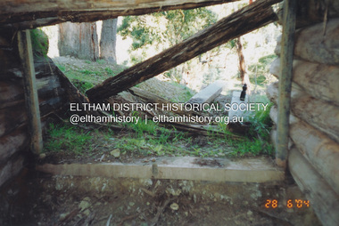 Eltham District Historical Society Inc
Photograph, Fay Bridge, Former Morrison property, Killeavey, Laughing Waters Road, Eltham, 28 June 2004
Beatrice Wanliss Irvine was the daughter of former Victorian Premier Sir William Irvine. From age 13 she lived at “Killeavey” off Laughing Waters Road (later accessed from Reynolds Road). In 1923 she married James Morrison and the couple received Killeavey as a wedding gift. The property supported fruit and vegetable growing as well as an impressive botanical garden. But James died in 1936 after a period of ill health, leaving Beatrice to support their six children. The Killeavey house was built atop a cliff, 40 metres above the Yarra River. The garden was designed in 1910 by William Guilfoyle who was the second director of the Royal Botanical Gardens. The house was totally destroyed in the Black Friday bushfires in 1939, but was rebuilt. Beatrice continued to live at Killeavey and became well regarded as a botanist and naturalist. She died in 1989 and is buried in Eltham Cemetery with her husband and one of their sons. The (rebuilt) house was demolished by Parks Victoria. It contains significant garden remnants. The surrounding bushland is valued for its significant plant communities.fay bridge collection, 2004-06-28, beatrice wanliss morrison (nee irvine), eltham, james morrison, killeavey, laughing waters road, william irvine -
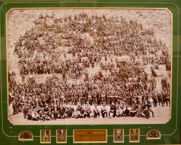 Lara RSL Sub Branch
Framed Print, Original photo 28/2/1915
The 11th Battalion, Australian Infantry was raised at Blackboy Hill Camp Bellevue in Western Australia on the 17th of August 1914. Following a period of training of just 2 weeks the Battalion embarked at Fremantle on the HMAS Ascantius on the 11th of November 1918. The Ascantius formed part of a convoy 38 troop ships carrying approximately 35,000 Australians and New Zealanders and reached the port of Alexandria Egypt on the 3rd of December 1914. After arriving in Egypt, the Battalion camped and trained at Mena, ten miles from Cairo at the foot of the great pyramid Cheops. On the 10th of January 1915 prior to leaving Egypt, a photograph of more than 800 original officers and men of the battalion was undertaken at the great pyramid of Cheops on the 28th of February 1915Historical photograph of the 11th Infantry Btn taken on the Cheops Pyramid Mena Egypt on the 28/2/1914Plastic framed print behind glass with plaque medals and two rising sun badgesAnzac and plaque describing the historical significance.11 battalion aif cheop pyramid egypt photo pegan anzac mena hmas ascantius -
 Marysville & District Historical Society
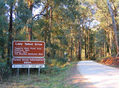
Photograph (item) - Colour photograph, 28-04-2004
A colour photograph of the brown tourist sign for Lady Talbot Drive in Marysville in Victoria.A colour photograph of the brown tourist sign for Lady Talbot Drive in Marysville in Victoria. Lady Talbot Drive a 24 kilometer scenic rainforest car journey which passes a number of walks and waterfalls in the Yarra Ranges National Park. Lady Talbot Drive is named after Lady Sarah Elizabeth, the wife of Sir Reginald Talbot, who was the Governor of Victoria from 25th April, 1904 to 6th July 1908.lady talbot drive, lady talbot forest drive, marysville, victoria, sir reginald talbot, lady sarah elizabeth talbot, taggerty river, phantom falls, keppel falls, the beeches rainforest walk -
 Federation University Historical Collection
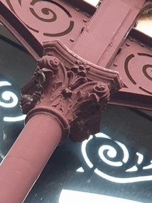
Photograph, Clare Gervasoni, Metal column, Ballarat School of Mines Administation Building, 2020, 28/09/2020
The Ballarat School of Mines was a predecessor institution of Federation University Australia. This photograph was taken during the Covid19 lockdowns. Metal column at the rear of the Ballarat School of Mines Administation Building.ballarat school of mines, a building, administration building, columns -
 Federation University Historical Collection
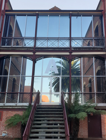
Photograph, Clare Gervasoni, Rear of the Ballarat School of Mines Administation Building, 2020, 28/09/2020
The Ballarat School of Mines was a predecessor institution of Federation University Australia. This photograph was taken during the Covid19 lockdowns. Metal columns ans stairs at the rear of the Ballarat School of Mines Administation Building.ballarat school of mines, a building, administration building, columns, stairs -
 Federation University Historical Collection
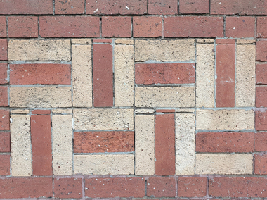
Photograph, Clare Gervasoni, Brick Detail at the Front of Ballarat School of Mines Administation Building, 2020, 28/09/2020
The Ballarat School of Mines was a predecessor institution of Federation University Australia. This photograph was taken during the Covid19 lockdowns. Brick detail at the front of the Ballarat School of Mines Administation Building.ballarat school of mines, a building, administration building, columns, stairs -
 Federation University Historical Collection
Photograph, Clare Gervasoni, Architectural Detail at the Front of Ballarat School of Mines Administation Building, 2020, 28/09/2020
The Ballarat School of Mines was a predecessor institution of Federation University Australia. This photograph was taken during the Covid19 lockdowns. Brick and stone architectural detail at the front of the Ballarat School of Mines Administation Building.ballarat school of mines, a building, administration building, columns, stairs -
 Federation University Historical Collection
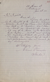
Letter, Letter Concerning the Ballarat State School Teachers' Literary Society, 28/06/1910
The Ballarat Teachers' Literary Society was established in 1895.Handwritten letter Concerning the Ballarat State School Teachers' Literary Societyballarat state school teachers' literary society, eleonor finlayson, teachers' club room, dana street primary school -
 Federation University Historical Collection
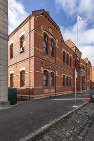
Photograph, Clare Gervasoni, Ballarat School of Mines Administration Building, 2020, 28/09/2020
This photograph was taken during the Covid19 PandemicDouble storey red brick building built as new classrooms for the Ballarat School of Mines.ballarat school of mines, adminsitration building, a building, covid19 -
 Lara RSL Sub Branch
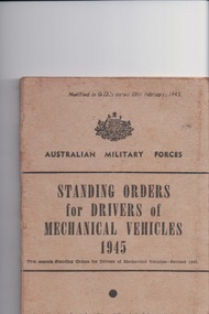
Booklet, Sands & McDougall, MelbournePty Ltd Printers, Standing orders for drivers of mechanical vehicles 1945 booklet, 28/2/1945
Was used in second world war as a training manual for drivers.Small booklet,Beige in colour made from cardboard and paper.These orders are designed to meet training in general and transport work in particular. they will be supplemented if necessary , by formation or unit orders to meet local conditions and circumstances.