Showing 438 items matching " brick home"
-
 Surrey Hills Historical Society Collection
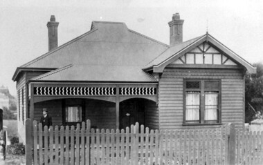
Photograph, 44 Guildford Road, Surrey Hills, c1915, 1913-1915
The gentleman in the photo is an estate agent. According to a grandson (REF: Email 1/8/2020) the original photos is thought to have been a publicity photo for the real estate agency. Carl Theodore Offszanka (1874-1944) was born in Germany. He is listed in electoral rolls at 44 Guildford Road from 1915, occupation furrier, with his wife Ida (nee Schade, 1882-1963), also born in Germany. They were married in Victoria in 1908. In later electoral rolls at the same address are Erna Helena (b 1913; d 1996) and Maria Eliese (b 1910; m Benedict Francis Rieusset in 1936). Both daughters are listed as typists. Also listed is Bernard George (b 1914; d 1987) who in later electoral rolls is described as a process worker. He served in the AIF in the Second World War. Not listed is Carl Bernard b 1909. The Offszanka family lived at 44 Guildford Road from 1913 until post-1980; they came to Surrey Hills from Richmond. Their home was called 'Westfalia' (ref: 1919 electoral roll), presumably after the region in NW Germany. It is not known when Carl and Ida migrated from Germany. This home has had a 2nd storey added to it in late 1990s. According to a family descendant (REF: Email 1/8/20 from grandson) Carl Theodor Offszanka purchased the home in 1913 for £616. He also purchased the adjoining vacant block of land at 42 Guildford Road and ran a large orchard on it before later selling it. This appears to have been between 1920-1930. The family continued to occupy the house until after 1980 when Erna Helena and Bernard George are listed in the electoral rolls. Our property register lists Erna Helena Offszanka as the last member there. She died on 5 May 1996. Black and white photo of a ? dark-stained timber Edwardian home at 44 Guildford Road, Surrey Hills. It has 2 brick chimneys, a corrugated iron roof and timber fretwork to the veranda. There is a single window to the veranda, 2 single windows down the LHS (facing) side of the house and a double window to the RHS (facing) side of the house. This appears to have coloured glass to the top section. The gable is decorated with timber and stucco and has a simple finial. The house has a simple timber picket fence and a driveway down the LHS (facing), in which a carriage is located. A gentleman in a hat stands on the veranda. A tall Victorian building can be seen in the far distance, on Canterbury Road.edwardian architecture, houses, guildford road, mr bernard george offszanka, mrs ida offszanka, miss ida schade, miss erna helena offszanka, miss marie eliese offszanker, furriers, mr carl theodor offszanka, westfalia, mr carl bernard offszanka -
 Surrey Hills Historical Society Collection
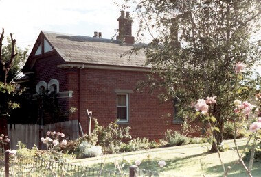
Photograph, Tavistock at 192 Union Road, 1978
The date is approximate. Tavistock was built c1890. The side windows on the front room are a later addition in a different style from the original windows. In 1897 it was the home of the Walker family; Joyce Walker later became matron of Mosgiel Hospital. In 1902 it became the first site of Milverton Girls School. From 1930s to 1960s it was home to Miss Marjorie Vahland, a locally well-known nursing sister. See History Walks No 5, p 11 and p32 Surrey Hills In Celebration of its Centennial 1883-1983Colour photo of the north side of Tavistock at 192 Union Road, Surrey Hills revealed when this side of the property was partially without a fence; taken while re-fencing. The house is Victorian in style, of red brick construction with a patterned slate tile roof and decorative chimneys.tavistock, milverton girls school, victorian style, houses, joyce walker, miss marjorie vahland, nurses -
 Surrey Hills Historical Society Collection
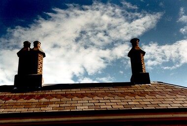
Photograph, Chimneys of 'Tavistock' at 192 Union Road, Surrey Hills, 1978
See History Walks No 5, p 11 and p32 Surrey Hills In Celebration of its Centennial 1883-1983 The date is approximate. Tavistock was built c1890. In 1897 it was the home of the Walker family; Joyce Walker later became matron of Mosgiel Hospital. In 1902 it became the first site of Milverton Girls School. From 1930s to 1960s it was home to Miss Marjorie Vahland, a locally well-known nursing sister.Colour photo of the roof and chimneys of 'Tavistock' at 192 Union Road, Surrey Hills. The house is Victorian in style, of red brick construction with a patterned slate tile roof and decorative chimneys.tavistock, milverton girls school, victorian style, houses, matron joyce walker, miss marjorie vahland -
 Surrey Hills Historical Society Collection
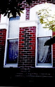
Photograph, Tavistock at 192 Union Road, 1978
See History Walks No 5, p 11 and p32 Surrey Hills In Celebration of its Centennial 1883-1983. Tavistock was built c1890. In 1897 it was the home of the Walker family; Joyce Walker later became matron of Mosgiel Hospital. In 1902 it became the first site of Milverton Girls School. From 1930s to 1960s it was home to Miss Marjorie Vahland, a locally well-known nursing sister.Colour photo of the front of Tavistock at 192 Union Road, Surrey Hills before restoration during 1978-1982. The house is Victorian in style, of red brick construction with a patterned slate tile roof and decorative chimneys. This photo of the windows at the front of the house is prior to stripping of the white paint from the decorative tiles.tavistock, milverton girls school, victorian style, houses, joyce walker, marjorie vahland -
 Surrey Hills Historical Society Collection
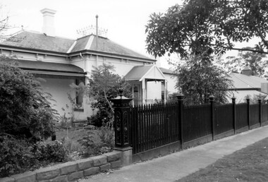
Photograph, "Ancyra" 25 Weybridge Street, Surrey Hills
John Butler Maling, retired farmer, built his home on the corner of his property which extended from Weybridge Street to Whitehorse Road and from James to Ross Street. From 1853 he lived in a simple farmhouse located near the present Ross Street until he had 'Ancyra' built in c.1889 from bricks made from clay dug from a quarry on the property. This was located in the now-park in James Street. John Butler Maling Snr was born in Shepreth, Cambridgeshire. He married Kate Conlan in 1882 and they had 3 children - Silas, Alick and Zillah. He died in 1912 and is buried in Box Hill Cemetery. Often referred to as John Butler Maling Senior as he had a nephew by the same name. He also lived on a similar sized property known as 'The Willows', located to the west. He became the first Mayor of Camberwell. From c1936 til c1960 the property was used as a rest home (Ancyra Rest Home) and then a nursery (Pied Piper Nursery).This property is important as one of few remaining extant links to pre-urban Surrey Hills, and built from local material.A black and white photograph of a brick house with a slate roof and corrugated iron over the verandah and portico. A picket fence painted a dark colour features decorative finals on the tops of the posts.ancyra, house names, weybridge street, surrey hills, whitehorse road, james street, ross street, john butler maling (snr), mrs kate maling, silas maling, alick maling, zillah maling, miss kate conlan, box hill cemetery, ancyra rest home, pied piper nursery -
 Surrey Hills Historical Society Collection
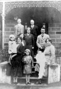
Photograph, Charles Henry Maling and family at 'The Willows', Shepreth Street, Surrey Hills (demolished), 1930s
“The Willows” home of John Butler Maling on south side of Whitehorse Road in Shepreth Street, near Banool Road. He built 2-roomed mud brick cottage in about 1861 extending it in stages into a weatherboard Victorian villa as his family grew. John Butler Maling's uncle (also John Butler Maling lived nearby at 'Ancyra' at 26 Weybridge Street). 'The Willows' was situated on a small farm of c13 acres with a creek running through it, lined with willows. The house was demolished after J B Maling's death in 1931 when the land was subdivided, some of it having been previously bought by the Education Department for the site of Chatham Primary School. J B Maling trained his six sons as builders. Charles Henry and his family are pictured in this photo. Charles Henry Maling (1875-1953) married Katherine Mitchell (1875-1958) in 1901. They lived at 9 Benson Street, Surrey Hills but came to live at 'The Willows' for 5 years prior to 1931 to care for Charles' father. Charles and Katherine are the older man and woman centre back with daughter Ellen Grace, known as Nell (1882-1960) in the front of them. Right front seated on the pillar is daughter Jane Emma (1872-1980) with her baby. Her husband Robert Wilhelm (Bob) Sutherland is the younger man at the back. The occasion is thought to be the christening of their first child. The other people are Rev O Cordell, his wife Mary and their children who are friends visiting from Africa where the donor, Rev Charles Maling, son of Charles Henry Maling was working with the Church Mission Society. A black and white photograph of a group of people standing (one lady sitting) on the front steps of a house.the willows, house names, (mr) john butler maling, whitehorse road, banool road, balwyn, surrey hills, (mr) charles henry maling, (mrs) katherine maling, (miss) nell maling, (mrs) jane sutherland, (mr) bob sutherland, (rev) o cordell, (mrs) mary cordell -
 Surrey Hills Historical Society Collection
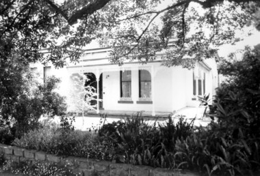
Photograph, "Ancyra", 25 Weybridge Street, Surrey Hills
John Butler Maling, retired farmer, built his home on the corner of his property which extended from Weybridge Street to Whitehorse Road and from James to Ross Street. From 1853 he lived in a simple farmhouse located near the present Ross Street until he had 'Ancyra' built in c.1889 from bricks made from clay dug from a quarry on the property. This was located in the now-park in James Street. John Butler Maling Snr was born in Shepreth, Cambridgeshire. He married Kate Conlan in 1882 and they had 3 children - Silas, Alick and Zillah. He died in 1912 and is buried in Box Hill Cemetery. Often referred to as John Butler Maling Senior as he had a nephew by the same name. He also lived on a similar sized property known as 'The Willows', located to the west. He became the first Mayor of Camberwell. From c1936 til c1960 the property was used as a rest home (Ancyra Rest Home) and then a nursery (Pied Piper Nursery). This is one of relatively few surviving houses that provides links to pre0urban Surrey Hills. It is also built from locally quarried material.A black and white photograph of a house viewed through the front garden.ancyra, house names, weybridge street, surrey hills, james street, bricks, john butler maling senior, miss kate conlan, mrs kate maling, alick maling, silas maling, zillah maling, ancyra rest home, pied piper nursery, box hill cemetery -
 Vision Australia
Text, AFB Loddon Mallee Regional Committee minutes: 8/7/1996 - 11/3/1997, 1996-1997
Held at the 'Mirridong' Home for the Blind, McIvor Rd, Bendigo, these minutes contain information on attendees, meeting chair, apologies, confirmation of minutes, reports including from Auxiliaries and the Building, house and grounds, matters arising from reports, recommendations, Life Governors awards, general business and the date of the next meeting. It was noted that a fundraising campaign had been established to raise $100,000 from the Mildura District community for a Radio station for the Print Handicapped at Mildura. The "Paving the Way" program which was designed to help build the National Information Centre at Kooyong had been launched. For a gift of $100, individuals, businesses and organisations may have their names permanently inscribed on the brick pavers used to create the area. The Centenary Appeal was in action to raise $750,000 to enable commencement of the re-development of the Mirridong Home for the Blind - Amy Bayne Wing. 1 volumemirridong home (bendigo), association for the blind -
 Surrey Hills Historical Society Collection
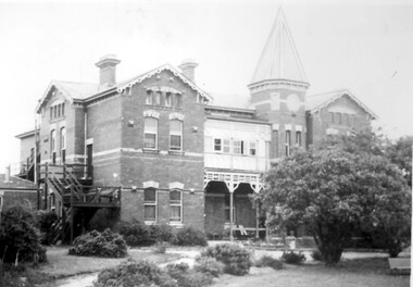
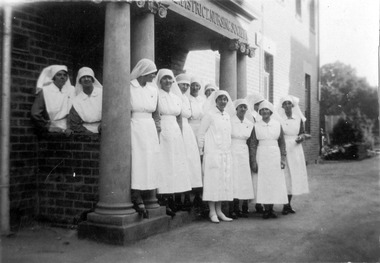
Photograph, Nethercourt Private Hospital, Union Road Surrey Hills in late 1930s
In 1935 Mrs Eliza tank transferred her private hospital 'Nethercourt' from Wilson Street to 219-223 Union Road. She has operated it at the Wilson Street address from 1916. The Union Road building had originally been Surrey College, a boarding school for boys built in 1889 by Rev Dr Darling. It was not the success hoped for. In 1905 it briefly became Milverton College for girls, after which it was used as a nursing home or small private hospital. By the 1960s it was known as 'Norwich Hospital' and later still 'St Jude's'. It closed as a hospital in 1983. The land at the front facing Union Road was sub-divided off and the building became a private home fronting Barton Street. As a private residence it was rendered and painted.Black and white photo of a double-storey brick building with a tower. There is a veranda between the tower and one of the wings of the building. This is enclosed at the upper level. On one side there is an external set of stairs and an out building. The building is approached by a circular driveway. There are mature bushes in front of the building.On copy photo in lead pencil: "? No & if missing"; "This is a copy"; "595"nethercourt hospital, milverton college, matron eliza tank, norwich private hospital, rev darling, st judes private hospital, hospitals, surrey college -
Federation University Art Collection
Artwork - Ceramics, Ceramic Containers by Ailsa Adern, c1950
Ailsa ADERN (1918-2006) Born New Zealand Arrived Melbourne 1942 Elsa Ardern arrived in Melbourne in 1942 to earn money for a trip to the United Kingdon. After marrying she settled at Warrandyte. In 1954, after her two children started school, Adern studied Pottery at Melbourne Technical College under John Bernard Knight. In 1961 she joined the Potters' Cottage at Warrandyte with friends Sylvia Halpern and Kate Janeba. She worked from a studio under the family home, exhibiting at the cottage and also through the Victorian Ceramic Group when it was set up in 1969. In 1980 she established a workshop at Tathra on the far south coast of NSW, sharing her time between Tathra and Warrandyte for the next 25 years. Amongst the work made at Tathra were some very large pieces which she fired in the Stafford Brothers' wood-fired brick-kiln at Kalaru. Part of the clay for these came from the Staffords' clay-pits. With Sylvia Halpern and Gus McLaren Ailsa Asern celebrated her long association with the Potters' Cottage by exhibiting in its 45th anniversary exhibition in 2003. 2. Her works are signed with an incised 'Elsa Ardern' or 'EA'.Two thrown and handworked 'bottles' featuring verticle ridges on the edge of each form. Her pots are valued for their strong form , ed by her characteristically subtle wood-ash glazes. ceramics, ailsa adern, pottery -
Federation University Art Collection
Artwork - Ceramics, Ceramic Forms by Elsa Adern
Elsa ADERN (1918-2006) Born New Zealand Arrived Melbourne 1942 Elsa Ardern was living at Warrandyte in 1954 when she started studying pottery under John Bernard Knight at the Melbourne Technical College. In 1961 she was a founding member of Potters' Cottage at Warrandyte with friends Sylvia Halpern and Kate Janeba. She worked from a studio under the family home, exhibiting at the cottage and also through the Victorian Ceramic Group when it was set up in 1969. In 1980 she established a workshop at Tathra on the far south coast of NSW, sharing her time between Tathra and Warrandyte for the next 25 years. Amongst the work made at Tathra were some very large pieces which she fired in the Stafford Brothers' wood-fired brick-kiln at Kalaru. Part of the clay for these came from the Staffords' clay-pits. Elsa Adern is known for her strong form of her pots, enhanced by her characteristically subtle wood-ash glazes. Her works are signed with an incised 'Elsa Ardern' or 'EA'. (http://www.australianpotteryatbemboka.com.au/shop/index.php?manufacturers_id=32)available, elsa adern, available ceramics, ceramics -
 University of Melbourne, Burnley Campus Archives
Photograph - Black and white print, Your Garden Magazine, A Good Example of Shrub Placement, 1960
Black and white photograph. Suburban house, white brick, two-storeyed at one side. Well maintained front garden lawn, neat flower beds, clipped trees and bushes. Woman in summer dress standing on front steps.On reverse, "A good example of shrub placement, blending with the home, yet not hiding it."shrub, placement, garden design, suburban house -
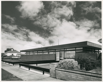
 Royal District Nursing Service (now known as Bolton Clarke)
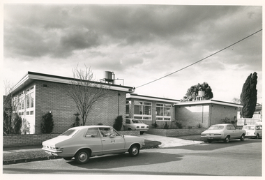
Photograph - Digital image, Barry Sutton, 12.07.1972
The photograph is taken outside the new Royal District Nursing Service (RDNS) Caulfield Centre. RDNS Sisters left in RDNS Torana vehicles from this Centre each morning to give nursing care to patients in surrounding suburbs and returned to the Centre after their visits. Gradually over the years, Melbourne District Nursing Service (MDNS), later known as Royal District Nursing Service (RDNS) from 1966 when they received Royal patronage, opened Centres throughout the Melbourne Metropolitan area and outer suburbs. In 1972 The Melbourne Centre which was conducted from RDNS Headquarters, 452 St. Kilda Road, was relocated to Caulfield and it became the Caulfield Centre. Their Trained nurses (Sisters) left from these Centres each morning to carry out their nursing visits in a specific area (district), taking any sterilized equipment needed with them. They returned at the end of the day to write up their patients nursing histories, clean and reset any equipment used ready for re-sterilization, and contact other medical and community personal as necessary. Most of the RDNS cars were housed at each Centre, only a few being driven home by a Sister. This is a black and white photograph of two RDNS two door grey Torana cars parked on the road outside a flat roof, one storey, light coloured brick building. The building is in three sections with the centre section set back. Part of the back of a white car can be seen in the driveway to the left of the set back section. Three large white framed windows can be seen along the end view of the left hand section and even larger windows are seen in the centre section. A small water tank and piping sit on a platform on the roof of both the left and right hand sections of the building. White fascia with dark trim above it edges the roof on each sections of the building. Some pencil shape type shrubs and a bare tree is seen in front of the building and a low light coloured brick fence runs across the property and down either side of the drive, with the footpath and nature strip in front of this. The back of a white car is seen on the road in the far right of the photograph and part of a wooden fence and parts of two large trees with leaves can be seen.Barry Sutton Photographer's Stamp. Quote KY 5rdns, royal district nursing service, rdns transport, rdns centre -
 Royal District Nursing Service (now known as Bolton Clarke)
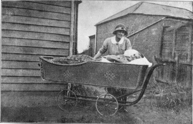
Photograph - Digital image, c.1920
This digital image is taken at the home of a Melbourne District Nursing Society (MDNS) patient, and depicts a MDNS Sister attending to a lady who is lying in a wicker bed pram in the rear garden of her home. The wicker bed pram enabled the lady to enjoy fresh air and to be moved about easily. The image shows the MDNS uniform of a grey cotton frock with white collar, and a grey brimmed hat with a red Maltese cross in the centre of the hatband. In 1885, 50 years after Melbourne was founded, it was recognized that nursing care was needed for the sick poor in inner Melbourne. The Melbourne District Nursing Society (MDNS) was founded in February 1885 with one Trained nurse, known as 'Nurse' in those days, and a second employed six months later,. The two Nurses worked in the now CBD, ie from Spencer Street to Spring Street and from Victoria Parade to Flinders Street. At that time they walked the streets and lane ways amid the slums of inner Melbourne carrying their nursing bags containing lotion, ointments, powders, liniment, bandages, dressings, a case of spirits, and the Nurse's own clean apron, soap and small towel. They supplied equipment on loan, such as earthenware hot water bottles, splints, urinals, bed pans, bed cradles, feeding mugs, and air-cushions as well as providing blankets and clean bed linen, and nightdresses as necessary. From its inception the Society was at the forefront of health care and liaised with Doctors. They provided high quality nursing care to a range of people, often in destitute situations, some lying on rags on the floor as they had no bed, others with just a bed and maybe a thin blanket, a chair and nothing else. Their ages ranged from babes, children, adults to the elderly. The Nurses gave medications as ordered, dressed wounds e.g. to the injured, and surgical cases, and to those with leg ulcers; attended to patients with ‘surgical ailments’ such as ‘hip disease’; gave care to those with acute illnesses such as bronchitis, pleurisy, pneumonia, measles, and scarlet fever, as well as those with chronic illnesses such as consumption (tuberculosis), heart disease, arthritis, cancer, debility, neuritis and paralysis. This image shows a Melbourne District Nursing Society (MDNS) Trained nurse (Sister) wearing a grey uniform with white collar, and a grey brimmed hat, which has a hatband with Maltese cross applied, standing behind and attending an elderly lady patient laying in a wicker bed pram outside her home. The Sister has her right hand resting on the pram and is looking down at the lady, and the lady, who has short grey hair, is smiling and looking toward the camera. Her body is covered with a floral cover. To the left, part of the horizontal weatherboards of a wooden house can be seen, and to the right and rear, a brick, tiled hip roof, building can be seen. The wicker bed pram has four spoked wheels and a metal frame that bends up to form a handle on its right hand side.melbourne district nursing society, mdns, mdns nurses, mdns patient care, mdns uniforms, rdns, royal district nursing service -
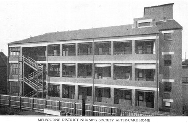
 Royal District Nursing Service (now known as Bolton Clarke)
Photograph - Digital image, c.1930
The name of the Melbourne District Nursing Society (MDNS) After-Care 'Home', changed to 'Hospital' in 1934 and major extensions occurred in 1936.Melbourne District Nursing society (MDNS) opened the After-Care Home, situated at 39 Victoria Parade Collingwood in 1926 following a public appeal for funds. The name changed from MDNS 'Home' to 'Hospital' in 1934. The After-Care Home was originally established to provide nurse-managed convalescent care to poor and underprivileged people who could not look after themselves at home due to illness or on release from hospital. Opening in 1926, at a cost of £27,000, the Home included maternity, children’s and adult wards as well as accommodation for Matron, twelve nurses and four domestic staff. In 1930 an ante-natal clinic was opened at the home. During 1934 the Women’s Welfare Clinic including, at the time, a very controversial Family Planning Clinic, the first of its kind in Australia, was opened to support women at risk following multiple and difficult pregnancies. Major extensions occurred in 1936. Following Government intervention, the After-Care Hospital was separated from the Melbourne District Nursing Society in 1957 and the District division of Melbourne District Nursing Society became the Melbourne District Nursing Service and relocated to 452 St Kilda Road, Melbourne. Following Royal patronage in 1966 this became the Royal District Nursing Service (RDNS). The After-care Hospital continued to operate at the same address in Collingwood until 1985 when it became the Melbourne Geriatric Centre. Black and white digital image taken of the rear of the Melbourne District Nursing Society (MDNS) After-Care Home showing, on the right, part of a three story section of the brick built new wing. Long windows are seen along each storey separated by brick work. Above each window is a wide light strip. Attached to this wing is a narrow three storey section with one long window, with light top strip, shown on each storey. Attached to the left of this are three walkways running to the left of the image. Tall metal handrails run along each walkway. In the background beyond the lowest walkway, part of a hip roof building and a leafy tree can be seen.melbourne district nursing society, after- care hospital, after care home, rdns, royal district nursing service -
 Royal District Nursing Service (now known as Bolton Clarke)
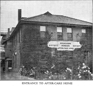
Photograph - Digital image, c.1926
The first After-Care Home in Melbourne was built by the Melbourne District Nursing Society (MDNS) in 1926 for patients of the Society who needed more nursing care than could be given at home but did not need hospitalization. Many patients from Melbourne hospitals who needed further care following discharge from hospital were nursed at the After-Care before going home. The Melbourne District Nursing Society, (MDNS), built the After-Care Home in 1926. The Home was extended and the name changed to Melbourne District Nursing Society and After-Care Hospital in 1934. It was situated at 45 Victoria Parade, Collingwood. Patients of the Society who needed more care than could be given at home, but did not need hospitalization were nursed there, along with many patients from Melbourne hospitals who needed further care before going home. Many children were nursed in the hospital, some long term, during the Polio epidemic and schooling was given to them in the hospital. In September 1930 an Ante-Natal Clinic was established. In October 1934 a Women's Welfare Clinic was opened to educate women on birth control. This was the first of its kind in Melbourne. The MDNS After Care Hospital was under District's banner until 1956. In 1957 the MDNS and the After-Care separated with the Government taking over the running of the After-Care. Melbourne District Nursing Society then became the Melbourne District Nursing Service and in 1966 was given Royal patronage and renamed Royal District Nursing Service (RDNS). Digital image of a front, and part of the left side view, of the Melbourne District Nursing Society After-Care Home and shows the entrance. The white plaque, attached in the centre of the brickwork between the two storeys in the front of the building reads 'Melbourne District Nursing Society After-Care Home' in black capital letters. It is a two story brick building with a tiled pitched roof, and shows two chimneys. There are four long windows running along both storeys of the front and side views. Near the rear left hand side of the building a portico can be seen and behind this part of a brick building with window runs to the left. Greenery is against part of the building and white flowers are seen in the foreground of the photograph. after- care hospital, after-care home, melbourne district nursing society, melbourne district nursing service, mdns, rdns, royal district nursing service -
 Royal District Nursing Service (now known as Bolton Clarke)
Photograph - Digital image, c.1930
The Melbourne District Nursing Society After-Care Home was built in 1926 to give short term care to MDNS patients who were too ill to remain in their home, but not ill enough to go to hospital. Melbourne hospitals also sent patients there who required further care after discharge from hospital. After convalescence they returned to their homes. Many children were nursed there, particularly during the Polio epidemic.The Society were pioneers in recognizing the need for premises where patients too ill to be in their own home, but not ill enough to go to hospital, was needed, and the Society built, then opened, the After-Care Home in 1926, (from 1934 called After-Care Hospital), for these patients, and patients from Hospitals. Many children were nursed there, some long term, during the Polio epidemic and the Society employed two School Teachers. The Society now ran two divisions, the After-Care with its own Trained nurses and the District division. The Society were the first in Melbourne, in early 1928, to recognize some patients leaving the After-Care, and many at home, needed further social care and they set up ‘Almoners’ from their Committee to visit these patients and be intermediaries in getting them social assistance. It was late the following year before the first training of Almoners took place in Melbourne. In 1930 the Society employed a full time kindergarten teacher to visit poor children in their homes. That year the Society were pioneers in opening an Ante-Natal Clinic at the After-Care, setting a high standard with equipment, keeping records and providing leaflets with instructions in how to keep healthy during pregnancy, what complications to look for, and what to do when labour commenced. In 1934 the Society were pioneers again when they opened the first Women’s Welfare Clinic in Melbourne giving advice on birth-control, at first attended by their own patients, but then accepting patients from public hospitals until their own clinics were opened. A trained Almoner was employed, but left after twelve months due to the amount of work required. Trained Almoners were in short supply so a Social Service Officer was employed at the After-Care who successfully gained better housing from the Housing Commission for families living under unsuitable conditions. In the 1950s the Hospital and Charities Commission decided to take over the After-Care Hospital, so the Melbourne District Nursing Society and After-Care Hospital separated and the Melbourne District Nursing Service was formed, setting up Headquarters at 452 St. Kilda Road. In 1966 Royal patronage was given and the name changed to Royal District Nursing Service (RDNS).Digital image of the rear of the extended Melbourne District Nursing Society After-Care Home 45 Victoria Parade, Collingwood. It shows a three story brick building with a tiled hip roof and open verandas running along each story with windows seen behind. A zigzag stair case runs down the left hand side of the building and on the right hand side of the image you can see a section set back with one window on each floor. Behind this section, part of another multi story building is seen. A wooden paling fence is seen in the foreground of the photograph. On the far right, part of another brick building with hip roof can be seen melbourne district nursing society, mdns, melbourne district nursing society and after-care home, rdns, royal district nursing service -
 Royal District Nursing Service (now known as Bolton Clarke)
Photograph - Photograph, black and white, 30 06 1965
This photograph is a record of the Melbourne District Nursing Service (MDNS) Moorabbin Centre, situated at 611 South Road, Moorabbin. It was opened in mid 1965 and was the fourth Centre MDNS had opened. Following Royal patronage in 1966, it became known as Royal District Nursing Service (RDNS) Moorabbin Centre.Gradually over the years, Melbourne District Nursing Service, MDNS, later known as Royal District Nursing Service, RDNS, from 1966 when they received Royal patronage, opened Centres throughout the Melbourne Metropolitan area. Their Trained nurses (Sisters) left from these Centres each morning to carry out their nursing visits in a specific area, taking any sterilized equipment needed with them. They returned at the end of the day to write up their patients nursing histories, clean and reset any equipment used ready for sterilization, and to contact other medical personal as necessary. Most of the RDNS cars were housed at each Centre, only a few being driven home by a Sister.Black and white photograph of RDNS Moorabbin Centre. The building is a single story brick building with a flat roof. A row of short glass windows are seen above the brick work to the left of the large glass doors which are on the right of the building. A low standing horizontal fence is seen along the front and along either side of the path leading up to the door. Some bushes are seen in the right hand side garden of the building. A footpath can be seen in front of the fence. On the left of the photograph can be seen a white house with a pitched roof. A dark sky with fluffy white 'cumulus' clouds are seen above the buildings.Photographers stamp. Quote No. DX 18mdns, melbourne district nursing service, mdns centres, royal district nursing service, rdns -
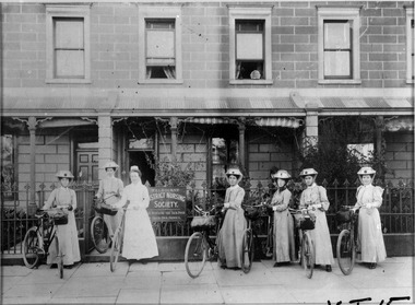 Royal District Nursing Service (now known as Bolton Clarke)
Photograph - Photograph, black and white, 1905
This photograph is a record of Head Nurse, Sister Lee-Archer, and her staff of six Trained nurses, 'Nurses', of the Melbourne District Nursing Society (MDNS) outside their new Nurse’s Home and Headquarters rented at 5 Royal Terrace, Nicholson Street, Fitzroy. The bicycles seen were the first mode of transport purchased by MDNS and allowed these Nurses to extend the nursing visits they made into more Melbourne suburbs.The Melbourne District Nursing Society (MDNS) moved into larger premises at No. 5 Royal Terrace, Nicholson Street, Fitzroy in May 1904. Head trained Nurse, Lee-Archer and her staff of six Trained nurses pose outside the new ‘Nurse’s Home’ at 5 Royal Terrace, Nicholson Street, Fitzroy. The Nurses worked in the districts of North and West Melbourne, the City Proper, Carlton, Richmond, South Melbourne, Fitzroy and Collingwood making 17,954 visits during the year. The Society had a set of bye-laws which outlined the work conditions for the Nurses. Section 111.1 states ‘Each nurse shall be ready to go to her district at 9 am. She will be expected to visit urgent cases on Sundays, and will be required to work eight hours on each week day, to wear the special uniform, and live in the Home of the Society’. In February 1885, only 50 years after Melbourne was founded, it was recognized that nursing care was needed for the sick poor in inner Melbourne. The Melbourne District Nursing Society (MDNS), the first Society of its kind in Australia, was founded with one Trained nurse, known as 'Nurse' in those days, and a second employed six months later. They liaised with Doctors and worked in the now CBD, ie from Spencer Street to Spring Street and from Victoria Parade to Flinders Street. From its inception the Society was at the forefront of health care. They provided high quality nursing care; educated their patients in the curing and prevention of disease; teaching the importance of cleanliness, fresh air and good nutrition, both by verbal instruction and demonstration, even supplying soup and milk when needed. At that time they walked the streets and lane ways amid the slums of inner Melbourne carrying their nursing bag containing lotion, ointments, powders, liniment, bandages, dressings, a case of spirits, and the Nurse's own clean apron, soap and small towel for her use. They loaned equipment, such as earthenware hot water bottles, splints, urinals, bed pans, bed cradles, feeding mugs, and air-cushions as well as providing clean bed linen and nightdresses as necessary. Trained Midwives began home births in late 1893 taking midwifery bundles and providing clothes for the babe and mother as needed. This was arduous work, particularly in the heat of summer. As the work increased a third Nurse was employed but due to this arduous work many Nurses only remained with the Society for several months. Permission to use bicycles was given to the Nurses in 1898 and the Society decided to purchase their own in 1903. A business man offered ‘new free wheel’ bicycles at £13 each which included maintenance for one year. Bells and wooden frames were added, at a cost of £5 per frame, so the Nurses could carry extra equipment. Nurses’ bags were strapped to the handlebars. Soup was made for those in need 2-3 times a week and if patients could not arrange to have it collected the soup was delivered by the Nurses on their bicycles. The use of bicycles caused a change in uniform, with white pith helmets, and veils covering them and tied under their chin, now being used. They provided high quality nursing care to a range of people, often in destitute situations, some lying on rags on the floor as they had no bed, others with just a bed and maybe a thin blanket, a chair and nothing else. Their ages ranged from babes, children, adults to the elderly. The Nurses gave medications as ordered by a Doctor, dressed wounds e.g. to the injured, and surgical cases, and to those with leg ulcers; attended to patients with ‘surgical ailments’ such as ‘hip disease’; gave care to those with acute illnesses such as bronchitis, pleurisy, pneumonia, measles, and scarlet fever, as well as those with chronic illnesses such as consumption (tuberculosis), heart disease, arthritis, cancer, debility, neuritis and paralysis. In 1913 a Nurse had her Board and residence, uniforms, bicycle and laundry expenses provided and was paid £50 a year for her first six months. At the end of a year her salary was increased by £5, and later she earns £60 a year. Over the years the nurses complained that their veils became wet in the rain and asked for a change of uniform but this did not occur until 1921. Bicycles continued to be used in inner areas until 1945. Black and white photograph of six Trained nurses and their Matron, who has her hair swept up, and is wearing a long white uniform with belt, and white cap; part of her veil is seen hanging down her back, outside their Nurses Home The trained. nurses are holding their two wheeled bicycles, and are wearing long grey frocks, white collars and belts and straw hats with a Maltese cross in the centre of headband, this is held in place with scarves over the hat and tied under their chins. Their nursing bags are strapped to the handlebars of the bicycles. A black sign with the white capital letters 'Melbourne District Nursing Society. ....nursing the sick poor in their own homes' is on the metal spiked fence. The building is made of brick and five long sash windows are seen in the upper section. A metal roofed veranda, held up with four posts and two brick columns, divides the upper and lower section. A door and three long windows are seen which are partly obscured by several bushes behind the fence.melbourne district nursing society, 5 royal terrace, nicholson st carlton, nurses home, bicycles, mdns transport, royal district nursing service, rdns, mdns trained nurses, sister florence lee-archer -
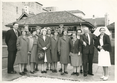 Royal District Nursing Service (now known as Bolton Clarke)
Photograph - Photograph, black and white, c.1960
The occasion of the photograph is unknown, but it depicts a group of Melbourne District Nursing Service (MDNS) Sisters with Matron Tupper. She is wearing the Matron uniform of a white frock and veil and a red cape. The Sisters are wearing their grey MDNS uniforms and one is wearing a uniform red cardigan. The Sisters peaked hats have a red Maltese cross applied in the centre front.From its foundation in 1885 the Melbourne District Nursing Society (MDNS), were instrumental in giving nursing care to patients in their own homes, and to assist them if they had financial problems or resided in poor living conditions. Miss Dorothy Tupper who, as a Trained nurse, had undertaken a course in hospital housekeeping at London Prince of Wales Hospital, was contacted by MDNS in 1939 and, possessing both business and humanitarian qualities, was asked to organize their newly established Social Service Department. As the MDNS Social Service Sister, she assessed the living conditions in patient's homes. She continued in this role until being appointed Matron of the Society's District Nursing division in 1941; a role she continued in until her retirement at the end of 1962.Black and white photograph of a group of seven Melbourne District Nursing Service (MDNS) Sisters and Matron Tupper with two men and four ladies standing in two rows in front of a brick house which has a tiled roof. To the left in the back row is a gentlemen with dark hair, who is wearing a dark suit, then two MDNS Sisters, next is a lady who is wearing glasses and is dressed in a light colour coat and hat. To her right is a tall MDNS Sister wearing dark rimmed glasses, then a lady with dark curly hair looking over the shoulder of a man with grey hair who is wearing a dark suit; on his right is Matron Tupper, who is wearing her white nursing uniform, her dark cape, and white veil over her short dark curled hair. In the left front is a Sister; to her right is a lady with dark curly hair and wearing a light coloured coat over a dark skirt and jumper; then a lady with blonde curly hair who is wearing a dark coat over her light dress and is carrying a handbag. Three Sisters are to her right - the end one is wearing glasses and a dark cardigan over her grey uniform frock The other MDNS Sisters in the group are wearing their grey uniform coats over their partly seen grey uniforms. All the MDNS Sisters are wearing grey uniform peaked hats. A three storey building is to the left rear of the photograph and and parts of three other buildings behind and to the right of the house.melbourne district nursing society, mdns, mdns social service department, mdns matron, matron dorothy tupper -
 Royal District Nursing Service (now known as Bolton Clarke)
Photograph - Photograph, black and white, c.1930
The Matron and Sisters in this photograph worked in the Melbourne District Nursing Society After Care Home, (later called Hospital) full time and administered nursing care to patients who ranged in age from babes to adults. The Society also had a District Nursing division and these Sisters only worked in the community giving nursing care to patients in their homes.The Melbourne District Nursing Society were pioneers in recognizing the need for premises where patients too ill to be in their own home, but not ill enough to go to hospital, was needed, and the Society built, then opened, the After-Care Home in 1926, (from 1934 called After-Care Hospital), for these patients, and patients from Hospitals. Many children were nursed there, some long term during the Polio epidemic and the Society employed two School Teachers. The Society now ran two divisions, the After-Care with its own Sisters and nurses, and the District division. The Society were the first in Melbourne, in early 1928, to recognize some patients leaving the After-Care, and many at home, needed further social care and they set up ‘Almoners’ from their committee to visit these patients and be intermediaries in getting them social assistance. It was late the following year before the first training of Almoners took place in Melbourne. In 1930 the Society employed a full time kindergarten teacher to visit poor children in their homes. That year the Society were pioneers in opening an Ante-Natal Clinic at the After-Care, setting a high standard with equipment, keeping records, and providing leaflets with instructions in how to keep healthy during pregnancy, what complications to look for and what to do when labour commenced. In 1934 the Society were pioneers again when they opened the first Women’s Welfare Clinic in Melbourne giving advice on birth-control, at first attended by their own patients, but then accepting patients from public hospitals until their own clinics were opened. A trained Almoner was employed by the Society in 1934, doing a great deal of work with Midwifery patients, but she resigned after twelve months due to the amount of work. Due to a lack of trained Almoners, the Society employed a Social Service Officer at the After-Care who successfully gained better housing from the Housing Commission for families living under unsuitable conditions.A black and white photograph of Matron and twelve Trained nurses (Sisters) standing at the front entrance of the Melbourne District Nursing Society After Care Home, In the front of the portico is the Matron and four Sisters. Matron is dressed in a white long uniform dress and white veil over her short dark hair, and is wearing white stockings and white shores. To her right are four Sisters. Behind them are five Sisters, one standing between the left pair of round columns of the portico and the others to her right finishing just before the second set of columns. Two Sisters are to the left of the left hand column in front of the brick wall of the building. A short brick wall runs from the column to the building and hides the lower half of these Sisters. All the Sisters are dressed with white long aprons with white belts, which are covering their uniforms, only their dark grey sleeves and white collars can be seen. They are wearing white veils covering most of their short dark hair, grey stockings and black shoes. At the top of the portico can be seen the words 'District Nursing Society'. Part of the two story brick building can be seen behind the group; two long windows are visible on the upper and lower sections. To the right of the building some shrubs and a tree can be seen.nurses, after care hospital, uniforms, after-care home, melbourne district nursing society, mdns, rdns, royal district nursing service -
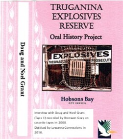 Truganina Explosives Reserve Preservation Society Inc (TERPS)
Digitised Oral History – Truganina Explosives Reserve - Tape 1 Doug and Noel Grant, 2018
The interviews were recorded in 2000 by Bronwen Gray and Alan Young for the production of Unreserved, Stories from Truganina Explosives Reserve, animated stories from past residents, workers and interested people of the Reserve (subject to copyright 2004). Doug and Noel Grant’s Grandfather, Don Grant, was officer in charge of Truganina Explosives Reserve from 1910-1930. On his retirement, his son, William (known as Bill) took over the position until 1956. Along with their two older brothers and younger sister, Doug and Noel Grant grew up, first in the assistant manager’s weatherboard cottage and then in the brick house which was set aside for the officer in charge, until they married and moved into their own homes in their early 1920s. On returning from the second world war, Noel Grant worked as a magazine assistant of explosives on the site from 1946, When the site had closed down in 1962 he worked as an inspector of explosives at the Explosives Branch in Melbourne until he retired in 1985. During that time Noel was asked to move back on site, meaning that three generations of Grants have lived on the site during the twentieth century. Doug Grant worked for ICI/Nobel in head office in 1940 and their older brother Alan worked at the Nobel Explosive Company in Deer Park from 1937. After returning from the Second World War, Alan bought a transport business that had once had the licence to cart explosives in and around the state. They discuss their memories of the living at Truganina Explosives Reserve and the workings of the Reserve, including the names of men who worked there, ships which carried the explosives and life in and around Altona. A primary source of information on memories of the Truganina Explosives Reserve and Altona,VictoriaDigital copy of original cassette recorded in 2000 and digitised in 2018hobsons bay, altona, galvanised iron fence, picket fence, golf course, altona school, margaret grant, bill grant, explosives magazine, lighters, joe hyde, alex grant, pines scout camp, maribynong river, 1896, inspector of explosives, pier, point wilson, werribee sewerage farm, george grant, lighterman, huia, argonaut, pirie, alma doepel, merton street altona, horse, jessie grant, jean grant, sandal, kilmartin, lewis, currie, todd, robinson, balwyn -
 Wodonga & District Historical Society Inc
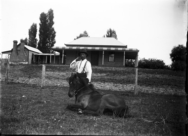
Negative - Haeusler Glass Negatives Collection - Jack Parker and the pony he taught to do tricks
The Wodonga Historical Society Haeusler Collection provides invaluable insight into life in late nineteenth and early twentieth century north east Victoria. The collection comprises manuscripts, personal artefacts used by the Haeusler family on their farm in Wodonga, and a set of glass negatives which offer a unique visual snapshot of the domestic and social lives of the Haeusler family and local Wodonga community. The Haeusler family migrated from Prussia (Germany) to South Australia in the 1840s and 1850s, before purchasing 100 acres of Crown Land made available under the Victorian Lands Act 1862 (also known as ‘Duffy’s Land Act’) in 1866 in what is now Wodonga West. The Haeusler family were one of several German families to migrate from South Australia to Wodonga in the 1860s. This digital image was produced from one of the glass negatives that form part of the collection, probably taken by Louis Haeusler (b.1887) with the photographic equipment in the Wodonga Historical Society Haeusler Collection. Parker Family - Samuel Skelton Parker, Jack Parker’s father, migrated to Australia from Ballymena, Country Antrim, Ireland in 1884. He married Bridget Cusack from County Clare in 1883. They had children William, James, Jack, Samuel and Rachel. After working on a station in northern NSW, they moved to Barnawartha and set up a butchery and later a bakery. In 1890 the family moved to Wodonga, buying a property in West Wodonga, which he called “Park Hall” after his home in Ireland. The property is now the location of the Wodonga Golf Club in Parkers Road, West Wodonga.This item is unique and has well documented provenance and a known owner. It forms part of a significant and representative historical collection which reflects the local history of Wodonga. It contributes to our understanding of domestic and family life in early twentieth century Wodonga, as well as providing interpretative capacity for themes including local history and social history.Digital image created from the Haeusler Glass negative collection. Jack Parker and his pony in the centre front of the image. Jack taught this pony to perform several tricks. The Parker family home and some outbuildings are visible in the background. This is a substantial brick house with corrugated iron roof.wodonga pioneers, haeusler family, glass negatives, dry plate photography, parker family wodonga -
 Wodonga & District Historical Society Inc
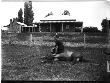
Negative - Haeusler Glass Negatives Collection - Jack Parker with the pony he taught to do tricks
The Wodonga Historical Society Haeusler Collection provides invaluable insight into life in late nineteenth and early twentieth century north east Victoria. The collection comprises manuscripts, personal artefacts used by the Haeusler family on their farm in Wodonga, and a set of glass negatives which offer a unique visual snapshot of the domestic and social lives of the Haeusler family and local Wodonga community. The Haeusler family migrated from Prussia (Germany) to South Australia in the 1840s and 1850s, before purchasing 100 acres of Crown Land made available under the Victorian Lands Act 1862 (also known as ‘Duffy’s Land Act’) in 1866 in what is now Wodonga West. The Haeusler family were one of several German families to migrate from South Australia to Wodonga in the 1860s. This digital image was produced from one of the glass negatives that form part of the collection, probably taken by Louis Haeusler (b.1887) with the photographic equipment in the Wodonga Historical Society Haeusler Collection. Parker Family - Samuel Skelton Parker, Jack Parker’s father, migrated to Australia from Ballymena, Country Antrim, Ireland in 1884. He married Bridget Cusack from County Clare in 1883. They had children William, James, Jack, Samuel and Rachel. After working on a station in northern NSW, they moved to Barnawartha and set up a butchery and later a bakery. In 1890 the family moved to Wodonga, buying a property in West Wodonga, which he called “Park Hall” after his home in Ireland. The property is now the location of the Wodonga Golf Club in Parkers Road, West Wodonga.This item is unique and has well documented provenance and a known owner. It forms part of a significant and representative historical collection which reflects the local history of Wodonga. It contributes to our understanding of domestic and family life in early twentieth century Wodonga, as well as providing interpretative capacity for themes including local history and social history.Digital image created from the Haeusler Glass negative collection. Jack Parker sitting on his pony which is lying down on the ground. Jack taught this pony to perform several tricks. The Parker family home and some outbuildings are visible in the background. This is a substantial brick house with corrugated iron roof.wodonga pioneers, haeusler family, glass negatives, dry plate photography, parker family wodonga, horsemanship -
 Wodonga & District Historical Society Inc
Mixed media - John Kenneth Darnton Watson and de Kerilleau Homestead
de Kerilleau was built for William Huon, son of the early pastoralist Paul Huon, in 1870 and named after the family's ancestral estate in France. The original lease of the Wodonga Run was granted to Paul Huon as No. 202 on 7th February 1837, about a year after his cousin Charles Huon had squatted on the land. Kenneth Darnton Watson bought de Kerilleau homestead in 1922 where the Watson family lived for three generations, caring for the land and serving the Wodonga community. Kenneth, his son Ian Darnton Watson and his grandson John Kenneth Darnton Watson all served on the Wodonga Council. The magnificent two storey brick homestead is built on ground above Wodonga Creek. The home of Georgian style consists of eleven rooms and a spacious cellar. At the rear of the main house in a separate single storey building was a large kitchen, pantry and accommodation for a cook and a housemaid. A feature of the homestead is the cast iron lace on the veranda and upper balcony, both supported by caste - iron pillars. The granite foundations of the home were quarried from the hill above the homestead. The enormous Moreton Bay Fig tree which stands to the side of the home was planted when Sir Charles Bowen visited de Kerilleau to mark the opening of the rail line that connects Victoria with New South Wales. Planted in 1873, it is still standing today. This painting was donated to the Wodonga Historical Society by George, Digby & Dugald Watson on behalf of the late John & Chris Watson. John Kenneth Darnton Watson was born on 28 August 1960 in Wodonga. After completing his primary schooling locally, he boarded at Geelong College from 1973. John joined the rowing crews, starting in the 8th VIII crew and reaching the 1st VIII crew in 1978. He received multiple House colours awards for cross country, athletics and rowing and received School colours for rowing. On completion of his schooling, John spent some time jackarooing before studying farm management at Marcus Oldham College in Geelong, Victoria. He then returned home to de Kerilleau, Wodonga to manage the family property. In 1984 John married Christine Honybun, daughter of David Lewis Honybun and Marian Josephine Edkins. John and Christine had three sons. John was community minded and involved in a number of local organisations such as Apex and agricultural societies. He was elected to Wodonga City Council in 1997, serving until 2004. Due to increased pressure on available land to cater for the growth of Wodonga, some of the property was sold and in 2003 John donated 200 ha of Huon Hill ‘s western slopes to the City of Wodonga. After this time, he moved away from farming to become a Hungry Jack's franchisee. In 2009, the hard decision was made to sell de Kerilleau and John and his family moved into Wodonga. After sadly losing Christine to cancer in 2017, John became a member and Deputy Chairperson of the Albury Wodonga Regional Cancer Centre Trust Fund Board and Ambassador for the Sunshine Walk. Tragically after his own cancer battle, John Kenneth Darnton Watson passed away on 24 August 2023, aged 62 years following a life of service to the Wodonga community.This item is significant because it was owned by a prominent Wodonga family and came from a Historic Homestead in WodongaA coloured portrait of John Kenneth Darnton Watson and a painting of de Kerilleau Homestead, the Watson Family home for three generations. The portrait was taken by Peter Charlesworth. The painting is the work of D.K. Ross in 1991.watson family wodonga, de kerilleau homestead, john watson, peter charlesworth -
 Linton and District Historical Society Inc
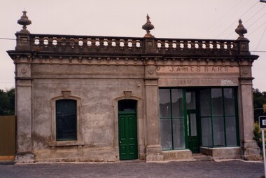
Photograph, Barr's Corner, Sussex Street, Linton, 1988, 1988
Formerly Barr's drapery shop, this building was the home of Bob Albert at the time the photograph was taken. It is still in use as a private home and has been considerably restored. Taken April 23-24 1988, during Heritage Week.Colour photograph of historic brick building with ornamentation on top. The name "JAMES BARR" over the shop front windows.buildings, shops, houses, james barr, barr's drapery, bob albert's house -
 Linton and District Historical Society Inc
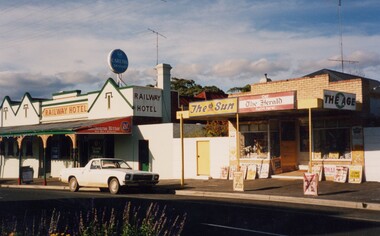
Photograph, Railway Hotel and Murrell's Newsagency, Sussex Street, Linton, 1988, 1988
Murrell's newsagency, originally the home & shop of the Cornish family. (Dan Cornish's shoe shop.)Colour photograph showing a brick two storey building with chimney, green trim and verandah, next to a smaller building with brick front and verandah.railway hotel, murrell's newsagency, buildings -
 Kew Historical Society Inc
Ceramic - Lamp base, Viola Ayling, 1950–1970
Viola Annie McVicars (1911–1990) was born in Korumburra on 29 April 1911. At the age of 21, she married William John Ayling (1909–1995). After their marriage in 1932, they moved to Kew, initially to 81 Tennyson Street, and later to 180 Pakington Street. A professional tailoress, Viola Ayling was also a talented amateur potter, creating her ceramics at her home in Pakington Street, where she had an internal studio and a handmade, wood-fired brick kiln in her backyard. Following her death in 1990, her studio pottery passed to her daughter, and following the daughter’s death, to her granddaughter. This piece of glazed earthenware is part of a collection of 15 functional and decorative ceramic items donated by Viola’s granddaughter to the collection in 2024.A handmade lamp base, expertly potted and glazed. The style is representative of Australian ceramic design of the period, particularly that employed by Klytie Pate.Handmade lamp base, irregularly ridged with applied green and yellow glazes. The lamp base has a hole for a cord above the foot.Signature to base: "V. Ayling"ceramics, pakington street -- kew (vic.), lamp bases, viola annie ayling, viola annie mcvicars -
 Stawell Historical Society Inc
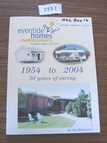
Book, Jim Melbourne, Eventide Homes Stawell Inc, A Great Place to Live, 1954 to 2004, 50 Years of Caring, 2004
... the other showing a large brick building Eventide Homes Stawell Inc ...A history of the Eventide Homes StawellWhite card cover with blue print and three colour photographs showing two showing houses the other showing a large brick buildingeventide homes Stawell inc. a great place to live 1954-2004 5o Years of caring by Jim Melbournestawell aged -
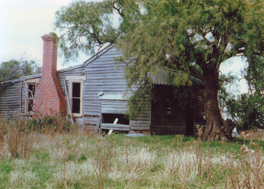 Lakes Entrance Historical Society
Photograph - Falk House, 1980 c
Colour photograph of the derelict Falk family home showing an unpainted weatherboard cottage with gable roof, skillion extensions at rear featuring sash windows each side of solid brick chimney, peppercorn treee beside front verandah. Kalimna West Victoriagenealogy, houses