Showing 442 items
matching residence areas.
-
 Flagstaff Hill Maritime Museum and Village
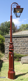
Functional object - Lamp Light, late 19th - early-20th century
This gas lamp light and stand came from the original manufacturer in Melbourne. Gas street lights such as this one were used in Melbourne from the mid-19th century. The lights enabled safer after-dark travel for pedestrians and vehicles and were a deterrent to crime. A lamp lighter was employed to keep the lamps lit, sometimes with little success due to weather conditions and the pranks of youths. WARRNAMBOOL Gasworks In Warrnambool prior to 1874 there were about twenty rare, individually lit street lights in Warrnambool, each with its own supply of kerosene. These lamps were in the central business area of Timor, Koroit and Liebig Streets. The Warrnambool Gas Company Ltd. was registered as an incorporated company in 1873. It was a private, locally owned business. It was located at 209-215 Merri Street, Warrnambool, on the land, which is just west of the later-built railway station. The first managers of the Gas Company lived in a substantial stone house on site, but later the managers lived in a residence in Henna Street between Merri and Timor Streets. The original home, which still stands, became a residence for the Railway Station Master from about 1890. In August 1874 the construction of the gasworks was complete and at the end of that month gas was supplied to all of the existing lamps in Warrnambool for the first time. The Warrnambool Gas Company wound up in 1880-1881 and was purchased by the Warrnambool Borough Council with money raised by a loan – the Borough’s first ‘loan transaction’. The Council established a piped network to supply gas to other street connections. The gasworks were privatised and upgraded in 1952. In 1972 the town supply was converted to liquid petroleum gas and by the early 1980s the gasworks were closed down. In 1986 Warrnambool was supplied with natural gas from a site near Port Campbell. The Warrnambool gasworks supplied all street and shop lighting and most domestic lighting until 1923 when electricity was available for lighting. Bromfield Street in Warrnambool was named after the director of the gasworks, James Astley Bromfield (1823-1903). He arrived in Warrnambool from Worcestershire, England, in 1852 and was very active in the local council and community. Cockman Street was named after the first secretary of the gasworks in 1874, Walter Cockman (c.1821-1892). He was a Mayor and businessman. The second Manager, Luther Rodgers, worked for the gas company for about twenty years and both Rodger Place and Rodgers Road in Warrnambool have been named after him. LAMP LIGHTS IN MELBOURNE In the 1820s Melbourne's innkeepers were legally required to have a lamp light outside their premises from sunset to sunrise. This was the first instance of street lamps being used in Melbourne. In 1847 the first oil lamp was used in the city. In 1849 a gas lamp was installed on the Swanston Street Bridge and much of the city had oil lamps installed by then. In August 1857 the installation of street gas lamps began in Melbourne. They were welcomed for the much brighter illumination they gave. By 1860 there were 414 lamp pillars. The phrase was quoted often - "A light was as good as a policeman". The first gas burners used for street lighting were called 'fishtail' gas burners. These were replaced in the early 1900s by gas mantles. The City of Melbourne Gas Coke Company was formed in 1850 but due to the Gold Rush the manufacture and distribution of the gas supply was delayed until January 1856. By the 1890s the gas supplying the lights was supplied by three companies in Melbourne. In 1879 a football match was played at the MCG under electric lighting and gradually electric arc lights were installed inside and outside buildings in the city. Lamp lights such as the one in Flagstaff Hill’s collection were no longer needed. (References: John Lindsay re Lamp Light history 2019-01-29, Former Warrnambool Gas Company Limited, Victorian Heritage Database Report, Heritage Number 149746 https://vhd.heritagecouncil.vic.gov.au/places/149746/download-report ) The lamp light is representative of the lamps used in Melbourne from the mid-nineteenth century to light the streets at night and make Melbourne a safer city. The lamp is also representative of the gas street lighting in Warrnambool from the mid-1870s-1920s.Lamp light or gas light. Street light, one of the last gas street lights removed from Melbourne. (Reconditioned by Friends of Flagstaff Hill, 2013)flagstaff hill, warrnambool, shipwrecked coast, flagstaff hill maritime museum, maritime museum, shipwreck coast, flagstaff hill maritime village, great ocean road, lamp light, gas light, gas lamp, street lamp, street light, gas street light, melbourne street lighting, warrnambool street lighting, melbourne gas street light, warrnambool gas company, warrnambool gasworks, james bromfield, walter cockman, luther rodgers, city of melbourne gas coke company -
 Kiewa Valley Historical Society
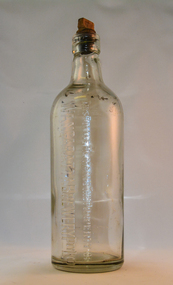
Bottle - Ginger Beer, mid to late 1900's
This bottle was used in a period when "soft" drink ginger beer was "brewed" not only in homes but also in specific breweries. Most rural areas had families which produced their own ginger beer. Medium to large towns and cities had ginger beer "factories". These factories had large "on bottle" advertising who the producer was. This producer advertising was firmly infused into the bottle and not on removable labels (late 1900's on wards). Regional breweries had a strong following, similar to State beer producing breweries. The competition between breweries of ginger beer was regional and not state or international. Return of bottles was not a sign of saving the environment or becoming eco- friendly but a requirement to keep production costs low. This is highlighted by "This bottle Remains the Property", in other words return when empty. Up to the end of the second World War Australian "soft drink" demand was for local produce. The American invasion of other flavours of "soft drink" came in the 1950's. Multi -Corporations producing non alcoholic beverages at lower production costs reduced local manufacturers considerably. This however had little effect on semi isolated rural areas where home brews flourished.This bottle shows the impact that small regional towns had and still have on semi isolated rural communities(Kiewsa Valley). With better communications (radio/television/newspapers) and a better transport connections specialised breweries such as the Wangaratta Brewery had an extensive customer "hinterland" to serve. The "canny" rural population would be able to reuse this bottle for their own specific purpose. Because of the long distances between Kiewa Valley residences and the major towns available to them, the issue of adaptability of any purchases made was always closely linked to their long term usefulness.This bottle is made from thick clear glass and has a capacity of one and a half pints. It has a flat top with a wooden screw stopper (internal thread). On one side "THIS BOTTLE REMAINS THE PROPERTY OF WANGARATTA BREWERY PTY LTD" On the top rim of bottle on both sides "17". On the bottom of the base are "AGM" AND "346"ginger beer bottle, soft drink bottles, cordial bottles, wangaratta drinks -
 Frankston RSL Sub Branch
Framed Artwork, Sketch of Frankston RSL Clubrooms, Davey Street, 1972
Framed artwork produced by artist Marie Minton, dated 1972. The artwork is an ink drawing with watercolour tonings and depicts the Frankston RSL Sub Branch clubrooms of the time. The artwork is mounted with a gold coloured wooden frame and glass front. Artist, Marie Minton was apparently the daughter of a member of the time, Laurie Minton. This scene is of a Frankston landmark building on the corner of Davey Street and Young Street, Frankston locally known as the 'Plowman Residence'. Prior to being the clubrooms of the Frankston RSL Sub Branch this building was the family home of Dr Sidney Plowman. In Dr Plowman's time the building was known as the 'The Lofts' and was his residence and operated as a private hospital, the building was constructed ca 1900. Dr Plowman died in May 1932. Title 'Frankston RSL' and the artist's name 'Marie Minton '72' appear on the front lower area of the sketch. The rear has the following note inscribed "Sketch of RSL clubrooms Davey St. by Marie Minton daughter of member (Laurie)" -
 Kiewa Valley Historical Society
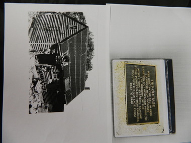
Wilkinson Lodge - copies of 6 photos, 1 plaque, 1 article
Wilkinson's Hut was built for the State Electricity Commission of Victoria in 1932 as a permanent residence for the snow research program manager, who was the resident engineer of the Kiewa Hydro Electric Scheme. The hut was sold in 1948 to the Ski Club of Victoria / Victorian Alpine Club and renamed Wilkinson Lodge. In 1958 it was sold to the Melbourne Bushwalkers Club. It was burnt down on 17th January 2004.Wilkinson Lodge was located at Wallace Gap on the Bogong High Plains and was the first S.E.C.V. permanent residence for the workers of the Kiewa Hydro Electric Scheme. It is also an early built lodge owned briefly 1946 - 1958 by the Ski Club of Victoria / Victorian Alpine Club and used by skiers before other lodges were built at Falls Creek. It was used by bushwalkers until it was burnt down thus in itself depicting part of the history of the area.5 pages of copies of photos of Wilkinson Lodge, 1 page of a copy of the destruction of Wilkinson Lodge (6 small photos), 1 page of a copy of a plaque titled 'This cottage' and 1 page of an article from the Border Mail (newspaper) dated 19th Jan. 2004.wilkinson hut; secv; ski club of victoria; melbourne bushwalkers club; fire -
 Kiewa Valley Historical Society
Four photographs of the Blue Duck Hotel and two Photos of the Glen Wills area, c1920 Post cards, c1949/50 small photographs
The Blue Duck Hotel stands at the confluence of 3 trout rivers - Cobungra, Bundarra and Mitta Mitta, called Angler's Rest. The original 1900's building was of slab construction and operated as a butcher shop, servicing miners on the track from Omeo to Mt. Wills. In 1912 it was purchased by a miner, Billy O'Connell, and he obtained a hotel license. In the early 1920's he transported 2 houses from Omeo on Horse drays. One is the main building of the Blue Duck and the other was a residence where Billy and his wife raised their nine children. The small log structure behind the pub is State School No.4286 where the children attended school. A teacher was shared with Glen Wills. By the late 1920's the hotel was discovered and patronized by keen anglers. Sir Harold Clapp (head of the railways) was one and he had the bronze blue duck cast and presented to the owners in the 1930's. This stands at the entrance to the premises.These photographs are of a building, in a remote area, that has provided a service to miners, anglers and travellers for over 100 years and continues to do so today. It also played a vital role in the history of the Mt. Wills/Omeo gold mining days.3 Post cards, Black and White photographs. 3 small black and white photographsPost Card No. 1 - "Blue Duck Hotel- Omeo-Glen wills road Ray Love Series No.2"(written on lower front) Post Card No. 2- "Looking towards Bogong High Plains. Omeo-Glen Wills road"(front, bottom, L hand) Ray Love Series No. 18 (front, lower R hand corner) On both of above photos, centre back, is stamped POST CARD and underneath this is printed "A GENUINE PHOTOGRAPH'/ Post Card No. 3 - Bottom L hand corner "Mystic Sea Australian Alps". R hand corner "(Bulmer Copyright)". Each small photograph, handwritten on back "Blue duck Hotel". All have circular stamp with "Print by Wilson White Albury" blue duck hotel; anglers rest; omeo highway; fishing; mining -
 Kiewa Valley Historical Society
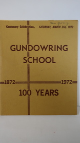
Book - Gundowring x2, Gundowring School 1872 - 1972 100 Years
A school was built in 1871, a shingle roofed wooden building built by the local residents. It was replaced in 1873 with the old school becoming the teacher's residence. The continues with a timeline, a pupil's insight into life at the school, a list of teachers and families. An interesting history of the area and education of the time. Gundowring is a farming town in the Kiewa Valley. The book gives an insight into the education and lifestyle of the time.Mustard cardboard cover with brownish print. Across the top "Centenary Celebration, Saturday, March 31st, 1973". It has 18 pages, some colored, printed on both sides and held together by 2 staples. It includes sketches.Glued inside the front cover "Mr & Mrs Roper & family" - Invitation. Also a newspaper cutting titled "Gundowring"gundowring, education, kiewa valley, school centenary -
 Victoria Police Museum
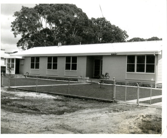
Police Stations (Apsley)
Apsley is a small town in Victoria, Australia. It is on the Wimmera Highway, in the Shire of West Wimmera, 420 kilometres north-west of Melbourne, and 7 kilometres east of the South Australian border. Apsley Police Station opened on 29th November 1884 and was originally located in Wallace Street. It was staffed by one Foot Constable (motor cycle). The building was described, in 1930, as a four-roomed dwelling with an iron roof, set on a quarter of an acre of land. There was a bathroom, a WC, wash-house and a garage. An office adjoined the house and there was also a lockup. The station moved several times until the mid 1960s when a timber residence was moved onto land adjacent to the Post Office. The building is believed to have been transported from the Stawell area. Apsley is one of a handful of one-man police stations in Victoria and its current location, including residence, is at 19 Splatt Street. Apsley was in the Western District when it opened, then in "L" (Wimmera) District from January 1948 and "M" (Highlands/Wimmera) District from March 1990. 4 black & white photos, 1965 3 colour photos, 1987police stations; apsley police station -
 Eltham District Historical Society Inc
Photograph, Edendale Farm, Eltham Heritage Tour, 24 May 1992, 24/05/1992
ELTHAM HERITAGE TOUR The Society excursion on 24th May 1992 was arranged by David Bick, leader of the team carrying out the Shire's heritage study. David selected a number of sites or buildings identified in the study, some of them lesser known components of the Shire's heritage. The tour commenced at the Eltham Shire Office at 10.00 am. Travel was by private car and mini-bus with stops at about twelve locations for commentary by David.It included a short walk in Hurstbridge and lunch at Kinglake. Highlights of the tour included: - 10 am Leave from Shire Offices - 3 Important Trees - A Physical Link to Eltham's First Settlers - Toorak Mansion Gates - A Surviving Farm House - An Intact Circa 1900 Main Street - First Settlers - Gold Miners, and Timber-getters - An Early Hotel - A Pioneering Homestead - Changing Eltham Shire - 20th Century - 4 pm Afternoon Tea and Finish Tour Extract from ELTHAM CULTURAL HERITAGE TOUR (Newsletter No. 85, July 1992, by Bettina Woodburn) "The land was unprofitable for intensive farming, but there was always water in the Diamond Creek. The railway, a technological advance, followed the valley, and was provided to transport produce. At North Eltham we were privileged to tour a surviving farmhouse of the 1860-70 era at the Shire’s Edendale Farm, with the as yet unfinished Sculpture for a front fence - bulbous tree-trunks decorated with salt pots, with cross members from the old trestle bridge. As was usual these six veranda posted houses faced South (or East, away from the sun!) with the scullery, kitchen and pantry "out the back". The veranda, which must have been very narrow, no longer exists. It probably wrapped around three sides. The drive took us past the Dutch Windmill, only twenty years old and in the Shire of Diamond Valley, then the Diamond Creek Cemetery with impressive gateway, to a detour to see another old farmhouse, isolated on a hill off Murray Road Wattle Glen. Here was a particularly thick patch of exotic planting of pines and cypresses. Subsistence farming no longer pays. Following the rail-line we noticed on the left near Silvan Road an Edwardian cottage and on the right near Yates Road the old school residence for this Upper Diamond Creek area."Record of the Society's history and activities and highlighting various aspects of the Heritage Study undertaken by David Bick used to create the future heritage overlay for the Shire of Eltham and later Nillumbik Shire.Roll of 35mm colour negative film, 4 stripsKodak Gold 100 5095eltham, shire of eltham historical society, activities, heritage tour -
 Eltham District Historical Society Inc
Photograph, Woodburn residence, mudbrick adobe (1949), Eltham Heritage Tour, 24 May 1992, 24/05/1992
ELTHAM HERITAGE TOUR The Society excursion on 24th May 1992 was arranged by David Bick, leader of the team carrying out the Shire's heritage study. David selected a number of sites or buildings identified in the study, some of them lesser known components of the Shire's heritage. The tour commenced at the Eltham Shire Office at 10.00 am. Travel was by private car and mini-bus with stops at about twelve locations for commentary by David.It included a short walk in Hurstbridge and lunch at Kinglake. Highlights of the tour included: - 10 am Leave from Shire Offices - 3 Important Trees - A Physical Link to Eltham's First Settlers - Toorak Mansion Gates - A Surviving Farm House - An Intact Circa 1900 Main Street - First Settlers - Gold Miners, and Timber-getters - An Early Hotel - A Pioneering Homestead - Changing Eltham Shire - 20th Century - 4 pm Afternoon Tea and Finish Tour Extract from ELTHAM CULTURAL HERITAGE TOUR (Newsletter No. 85, July 1992, by Bettina Woodburn) "In some respects Eltham is a 'back-water' and it has its own distinctive flavour. On the outskirts the homes date from the 1960's, 70's and 80s with a sprinkling of 'earth homes', mud-brick or pise, rammed dirt. Crossing Main Road into Beddoe Street and Thompson Crescent a very pleasant drive past pines and old fence lines, front lawns unfenced, the occasional ·old farm building, we eventually looked down on a huge circular roof of a 1992 adobe home. Other distinctive places included the Pauline Toner Butterfly Reserve, Gordon Ford's splendid garden at Fulling in Pitt Street, cypress hedges and old houses in Bridge Street and in every direction Eltham's special feature - a totally treed horizon. We were now in the part of the Shire closest to Melbourne - Montmorency - not on the way to anywhere, with no through road going across it, developed in the 1950's and 1960's with conventional gardens, now converted to native plants. The rail looped between Greensborough and Eltham and a shopping street (Were Street) served the area, growing up the hill from the station. It was a typical outer Melbourne suburb with lawns and roses with patches of originality. The shopping precinct still has 1950 characteristics - walls which sloped back, projecting roofs, the original shop fronts are nearly all tiled below the old windows. There's an air of past times about the School, the Dairy, the Butcher's (now a milk bar) and the Castlemaine stone face of the Commonwealth Bank. The final stop for the tour was at the mud-brick Woodburn residence, adobe of 1949 with additions. After War Service, Bill Woodburn had commenced an Architecture course at Melbourne University and after second year in the Christmas vacation, with his wife, Betti, built the two bedroom house - with amazing saving of costs. In the three and a half months they made over 3000 bricks (external walls 18" x 12" x 4", internal walls 12" x 9" x 4"), sifted top soil for mortar and laid them, on concrete foundations and slab floor, made all the structural window frames, door frames and roof members to carry 'super six' asbestos sheets, laboured for the electrician and plumber, did all the glazing and, still without electricity, moved in in March 1949. Rooms have been added, at first with glass walls, later using concrete blocks, to accommodate three daughters and a son. The house not only grew from the earth, but also with the family."Record of the Society's history and activities and highlighting various aspects of the Heritage Study undertaken by David Bick used to create the future heritage overlay for the Shire of Eltham and later Nillumbik Shire.Roll of 35mm colour negative film, 4 stripsKodak Gold 100 5095shire of eltham historical society, activities, heritage tour, woodburn house -
 Warrnambool and District Historical Society Inc.
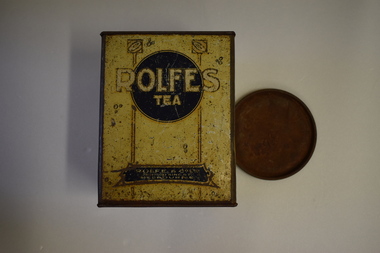
Tea Tin (Rolfe), Artefact, Early 20th century
This is a tea tin from the business of Rolfe and Co., a wholesale grocery and importing business founded in Melbourne in 1854 by George Rolfe Senior, a merchant and politician. George Rolfe died in 1871 and the business was then run by his son, George Rolfe, Junior. The business continued until at least the late 1930s. George Rolfe (1836-1919) was a keen sportsman and he began holidaying in Warrnambool for some years in the 1870s when he started buying land in the area. By the early 1880s Rolfe owned 50 acres in Warrnambool and established his holiday residence at Lyndoch near the mouth of the Hopkins River. He improved the original site with the addition of a large garden, stables, jetty, boatshed, water well, chaff and bone sheds, reservoir etc and bought other properties including Shipley on the Allansford Road and the adjoining property Fairy Hill. He continued managing the Rolfe and Co. business in Melbourne until his death in 1919. Today Rolfe’s Lyndoch property in Warrnambool is the site of an aged care facility. This tin is of considerable significance as it is a memento of George Rolfe who established the property of Lyndoch in Warrnambool and was a prominent land holder in the late 19th and early 20th centuries. (Note that we have another Rolfe tea tin but it is in very poor condition compared to this later acquisition). This is a rectangular-shaped tin with four sides originally painted yellow but now showing considerable rust. The printing on the sides is brown and white, some on a blue background and some surrounded by decorative patterns.No. 2 Rolfe & Co. Ltd 286-300 King St. Melbourne Rolfe’s Tea Rolfe and Co. was established at Melbourne in 1854. Ever since then it has enjoyed an enviable reputation as a firm which supplies to the public goods of the highest quality. george rolfe, lyndoch warrnambool, rolfe & co, importers, melbourne, history of warrnambool -
 Surrey Hills Historical Society Collection
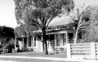
Photograph, 1 Russell Street, Surrey Hills in 1988
1 Russell Street was built in 1888 and from 1888–1905 (maybe 1911, as his death notice says he died at Russell Street) it was the home of James Burrell, a blacksmith. His smithy was on the corner of Canterbury Road. In 1893 a block of land (No.3 ) was bought to establish the fire station and James Burrell acted as fire officer and stored the reel and hose until the station was built. From 1911–1928 it was the fire station residence, as the brigade gained status. James Burrell (1860-1911) married Elizabeth Wilson (1862-1925). She was daughter of Edward Wilson. They had 4 children: James Herbert, known as Bert (1888-1953); Aleck (1890-1951); William Spencer, known as Bill, (1893-1976) and Elsie May (1898-1990). Both James and Elizabeth Burrell are buried in Burwood Cemetery. From 1930–1943 Michael Ginnane, retired station master, and members of his family lived in the house. Michael Ginnane (1864-1935) married Annie Mary Brock (1868-1945). Both were born in the Ballarat area. They had 10 children. From 1913-1917 he was station master at Woodend. In the 1925 electoral rolls the family is listed as living at Surrey Hills station. There was a station master's house adjacent to the station (demolished and the site now part of the car park accessed off Blackburn Street). They are again listed here in the 1925 electoral roll. By 1931 they are at 1 Russell Street and he is listed as a retired station master. The following children lived in Surrey Hills: John James (Clerk) - 1922 Mary Ellen (HD) - 1922, 1925, 1931 Michael Thomas (labourer) - 1922 Annie Florence (dressmaker) - 1925, 1931 William Patrick (railwayman) - 1925 Elizabeth Catherine (sales) - 1931 Patrick Leo (postman) - 1931. A black and white photograph taken on an angle from across the street of a mid-late Victorian style cottage with multi-coloured brickwork. There is a large tree in the front garden, no fence and a letterbox on a lean.(mr) james burrell, blacksmiths, canterbury road, surrey hills, fire officers, (mr) michael ginnane, station masters, fire stations, mid-victorian style, (miss) elizabeth wilson, (mrs) elizabeth burrell, james herbert burrell, aleck burrell, william (bill) spencer burrell, elsie may burrell, (miss) annie mary brock, (mrs) annie mary ginnane, john james ginnane, (miss) mary ellen ginnane, michael thomas ginnane; (miss) annie florence ginnane; william patrick ginnane; elizabeth catherine ginnane; patrick leo ginnanean), late-victorian style, russell street -
 Federation University Art Collection
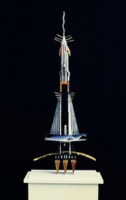
Sculpture, Thomas, Kylie, 'Cultural Dedication' by Kylie Thomas, 1993
Kylie THOMAS (14 May 1973 - ) Born Creswick, Victoria A graduate of the Bachelor of Arts (Visual Arts) (1993) and Diploma of Visual Arts (1995) from Federation University (then University of Ballarat) Kylie Thomas continued her art practice after studying under distinguished sculptors Peter Blizzard and Adrian Mauriks. This work was acquired from her graduate folio. Soon after completing her studies Kylie Thomas became an artist in residence at Ballarat Grammar School building a public sculpture for the grounds conceived by one of her selected students as part of the program. She became the youngest exhibiting applicant to be awarded the City of Port Phillip, Rupert Bunny Foundation artist in residence program. After moving to Mallacoota she was absorbed into the community as a visual artist, actor, playwright and assistant publicist. Her commissioned public artwork and sculptures as part of residences collections were all lost in the 2019 bushfires that decimated Mallacoota. Moving back to her hometown of Creswick Kylie Thomas completed a Diploma in Education qualifying as a secondary teacher, always continuing her art practice while teaching. Needing to work again, but with no desire to teach, Kylie Thomas studied Building Design and Architectural Drafting, homing in on other areas which could link back to her artistic practice. Working in this field for a short time she moved to Melbourne where she exhibited paintings and sculpture installations as part of The Melbourne Fringe Festival. She also worked in set design, and as a stage manager and theatre actor. This item is part of the Federation University Art Collection. The Art Collection features over 2000 works and was listed as a 'Ballarat Treasure' in 2007.This work is a spiritual totem created in the tradition of the bricoleur, dedicated to bygone cultures, lost technology and mystery referencing nature, humanity and technology. Humanity to use technology with and for nature. The materials are symbolic, the use of bone, Perspex, computer parts, found and crafted objects constructed in a resulting harmony creating a symbiotic relationship. Tapping the 4th dimension that could lift off into space and come back again, with a feeling of weightlessness, awe and suspension captured. A sculpture which stands on a white pedestal with perspex cover. 'Cultural Dedication' is the final work in a series of sculptures influenced by the ancient cultures of Egypt. art, artwork, kylie thomas, sculpture, alumni -
 Williamstown Botanic Gardens- Hobsons Bay City Council
Postcard - Williamstown Botanic Gardens, c1900-1910
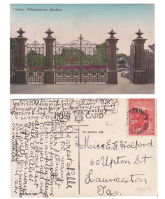
The original postcards in this series (2013.002 to 2013.018) were generously loaned to Williamstown Botanic Gardens by a private collector for copying. The cast iron gates (manufactured in Glasgow) introduced at the North West entrance in 1907. The gates were purchased from ‘Fairlie” corner of Acland and Anderson Streets, South Yarra at the cost of 72 pounds and cost 60 pounds to install. They had originally cost the owners of ‘Fairlie’ 1200 pounds. The postcards are evidence of the interest the gardens held as a subject for postcard publishers. The text and images provide a snapshot into fashions, social interests and concerns of the time. The professionally produced images provide a pictorial history of Gardens including changing planting styles, various structures and features of the Gardens eg the aviary, cannons, the fountain, the second Curator’s Lodge and gates. The images offer an opportunity to compare garden vistas with the present day. The image in this postcard shows the gates intact and as installed in 1907. The current layout of this area still reflects the change of design, which followed the 1907 removal of the first gardener's residence and the subsequent re-organisation of this quarter of the gardens. This postcard is evidence of the placement of one of the cannons relocated from Fort Gellibrand in 1906. They were removed from the Gardens in the 1960s. These same cannons remain a feature on the Williamstown waterfront in 2013. Postcard in colour of main entrance gates, one of the cannons can be seen through the pedestrian gate on the right. The gates are cast iron, double carriage gates with single pedestrian gates on either side and supported by four cast iron posts with ornamental finials. Front: ‘Gates, Williamstown Gardens’. Reverse: Vertical on left side of card ‘O Rippon Se..es’ [name of the publisher is unclear]. Top centre of card: ‘POST [logo of card publisher] CARD’. Left side of card: ‘This space may be used for communication.’ Right side of card: ‘for Address only.’ Left bottom corner: ‘Printed in ……..’ [name unclear]. Top right hand corner: a red one penny Tasmanian stamp with a depiction of Mount Wellington. Bottom right corner in pencil ‘1908’ believed to be inserted by the vendor. The card is dated 15.5.10 by the sender. It is addressed to Miss E G Holford of Launceston, Tasmania and sent by Addie.postcard, gardens, post-card, williamstown-botanic-gardens, hobsons-bay-city-council, entrance gates, entrance-gates, cast iron, finials, cannon, 1910, 1908, tasmania, tasmanian-stamp -
Stawell Historical Society Inc
Archive - Book, Registration of Residence Area 24-9-1906 - 9-11-1910, 1897
... Registration of Residence Area 24-9-1906 - 9-11-1910... grampians Book Archive Registration of Residence Area 24-9-1906 - 9 ...Resident Areas Miners Right Also Cat No 4235-10 Local GovernmentLarge Navy Blue Ledger Book with Red Spine and corners General Register 8P -
Stawell Historical Society Inc
Archive, Register of Residents Area 12/1/1865 - 20/8/1878
Records of Residents. Site Occupier, Miners Right 12 Jan 1865 - 20 August 1878Large brown Ledger Book Red Leather Spine Cover, Crown on SpineRS1 (Residence Site)local government -
Stawell Historical Society Inc
Archive, Register of Residents Area 21/8/1878 - 17/8/1882 and 1934 - 1936
Records of Residents. Site Occupier, Miners Right 1878-1882 & 1934-1936Large brown Ledger Book Red Leather Spine Cover.RS2 (Residence Site)local government -
 University of Melbourne, Burnley Campus Archives
Newspaper - Newspaper Cutting, The Australian Garden Lover, The Burnley Gardens, October 1926
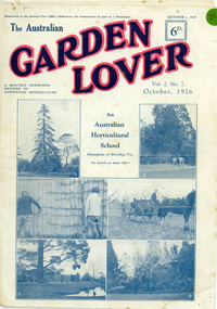
On cover pages are 6 photographs of Burnley College and the heading "An Australian Horticultural School Enterprise at Burnley,Vic". The 4 photos on the lower half of the cover page were used in "Green Grows Our Garden", by A.P Winzenreid, Hyland House (1991) p. 52. A.P Winzenreid described the photos as: Top left (photo 3): Espaliered fruit tree on fence, established and trained by George Russ and continued as a feature of interest into the 1950s. Located in old nursery area. Top right (photo 4): orchard spraying. Bottom left (photo 5): View of pavilion. Note Luffmann's pond and Pinus radiata planted in 1860s and removed by G. Manley and A. Tylee (1951-53). Bottom right (photo 6): A.W. Jessep (principal) and E.E. Pescott (lecturer) outside Principal's residence. (Photos 1 and 2 on the cover of the Garden Lover were not reproduced in "Green Grows Our Garden". The Australian Garden Lover, vol. 2 no. 7, October 1, 1926, p 266-7. Cover and two pages.the australian garden lover, green grows our garden, a.p. winzenreid, george russ, espaliered pear, old nursery, orchard, spraying, pavilion, ponds, pinus radiata, a. w. jessep, e. e. pescott, principal's residence, gardening publication, horticulture newspaper, 20s gardening -
Stawell Historical Society Inc
Archive, Ararat Districts – Pleasant Creek Division Application for Residence & Business Area 1880
... Residence & Business Area 1880... Application for Residence & Business Area 1880 Stawell Government ...stawell, government -
 Hume City Civic Collection
Photograph, Bulla State School, 1930
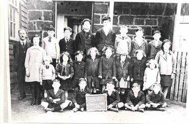
The class photograph was taken at the Bulla State School No. 46 in 1930. Two children have been identified. They are John Daniel, seated in the front row, second from the left. Vincent Daniel is standing, first on the left in the back row. The Daniel family were store holders in the Bulla township. Over the years a teacher's residence and another larger weatherboard classroom were added to the original bluestone building. The school functioned for over 100 years from the late 1870s until 2005 when it was closed and is now a private house.The Bulla State School was one of the oldest schools in the district and served the children from surrounding areas. A black and white school photograph which has been photographed from another image. The twenty two children of twelve boys and ten girls are in three rows and standing in front of a bluestone building with their teacher.bulla state school no46, daniel john, daniel vincent, schools -
 Kew Historical Society Inc
Plan, Melbourne & Metropolitan Board of Works : Borough of Kew : Detail Plan No.1591, 1905
The Melbourne and Metropolitan Board of Works (MMBW) plans were produced from the 1890s to the 1950s. They were crucial to the design and development of Melbourne's sewerage and drainage system. The plans, at a scale of 40 feet to 1 inch (1:480), provide a detailed historical record of Melbourne streetscapes and environmental features. Each plan covers one or two street blocks (roughly six streets), showing details of buildings, including garden layouts and ownership boundaries, and features such as laneways, drains, bridges, parks, municipal boundaries and other prominent landmarks as they existed at the time each plan was produced. (Source: State Library of Victoria)This plan forms part of a large group of MMBW plans and maps that was donated to the Society by the Mr Poulter, City Engineer of the City of Kew in 1989. Within this collection, thirty-five hand-coloured plans, backed with linen, are of statewide significance as they include annotations that provide details of construction materials used in buildings in the first decade of the 20th century as well as additional information about land ownership and usage. The copies in the Public Record Office Victoria and the State Library of Victoria are monochrome versions which do not denote building materials so that the maps in this collection are invaluable and unique tools for researchers and heritage consultants. A number of the plans are not held in the collection of the State Library of Victoria so they have the additional attribute of rarity.Original survey plan, issued by the MMBW to a contractor with responsibility for constructing sewers in the area identified on the plan within the Borough of Kew. The plan was at some stage hand-coloured, possibly by the contractor, but more likely by officers working in the Engineering Department of the Borough and later Town, then City of Kew. The hand-coloured sections of buildings on the plan were used to denote masonry or brick constructions (pink), weatherboard constructions (yellow), and public buildings (grey). That area of Kew bordered by Cotham Road, Park Hill Road, Ermington Lane (now Ermington Place), and Belmont Avenue contained some of the significant homes owned by Kew pioneers. Chief among these was ‘Park Hill’ on an enormous lot facing Park Hill Road. The Jubilee History of 1910 noted, six years after this plan was drawn, that: ‘Park Hill Road, forming the southern boundary of the cemetery, takes its name from Park Hill, the residence of Mr. Thomas Judd, who has resided there since December, 1852.’ Other named houses on the plan include ‘Ferndale’ facing Cotham Road; ‘Ermington’ adjacent to Judd’s Park Hill, facing Park Hill Road; and ‘Gilden’ and ‘Mont Belmont’ facing Belmont Avenue. Mont Belmont was designed by the architectural firm of Reed, Henderson and Smart for William George Lilley in 1887 and was completed in 1888. Lilley was Mayor of Kew in 1887-88, a Justice of the Peace and a member of the first Board of Guardians of Kew’s St. Hilary’s Church of England.melbourne and metropolitan board of works, detail plans, survey plans - borough of kew, mmbw 1591, cartography -
 Kew Historical Society Inc
Photograph, Willsmere Bridge, 1934
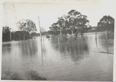
Several boathouses were built in Kew and Fairfield in the late 19th and early 20th centuries. They included Chipperfield’s ‘Moorings’ and floating pontoon. The substantial two-storey house was named the Moorings, and incorporated an upper storey residence. The Moorings was almost washed away in the 1916 floods, and in 1934 almost totally submerged when the Yarra River rose 26 feet in 14 hours. Following the 1934 flood, the house was restored. The floating pontoon, sometimes referred to as a ‘kiosk’ or ‘canteen’, was used to store canoes. Both were removed in 1972 for the construction of the Eastern Freeway.This work forms part of the collection assembled by the historian Dorothy Rogers, that was donated to the Kew Historical Society by her son John Rogers in 2015. The manuscripts, photographs, maps, and documents were sourced by her from both family and local collections or produced as references for her print publications. Many were directly used by Rogers in writing ‘Lovely Old Homes of Kew’ (1961) and 'A History of Kew' (1973), or the numerous articles on local history that she produced for suburban newspapers. Most of the photographs in the collection include detailed annotations in her hand. The Rogers Collection provides a comprehensive insight into the working habits of a historian in the 1960s and 1970s. Together it forms the largest privately-donated collection within the archives of the Kew Historical Society.A view of flooded areas in North Kew in the flood of 1934.Willsmere Bridge. Chipperfields. 1934 floodwillsmere, flood, yarra flood, chipperfields, chipperfields boathouse, north kew -
 Kew Historical Society Inc
Photograph - 'Wimba', Cotham Road, J E & B L Rogers, c.1965
'Wimba' is of significance as one of the key nineteenth century houses of Kew and for remaining in a substantially intact state. Although probably built some time earlier, the first mention in the Rate Books of the property later known as 'Wimba Lodge' appears in the entry for 1870 when the property, owned by John Sharpe Denbigh, a civil servant, was given an N.A.V. of £72 2. Denbigh did however occupy a house in Cotham Road in 1863, and it is possible that was the same premises'. The house was occupied by Denbigh until at least May 1876 when the 'family residence...' \ 'as auctioned to Carlington George Edmund Marston 5, a chemist of Smith Street, Collingwood. At the time of the auction the house was described thus: The residence and grounds of the late J.S. Dendigh, situate in the most elevated part of Cotham Road Kew. The grounds comprise an area of 4a Or29p or thereabouts, and have a frontage to Cotham-road of 4 chains. The house has two large rooms in front, with 6ft hall built of brick, bay and side windows (plate glass), four rooms of wood behind with slate roofs, bathroom and closets, detached kitchen and servant's room, large shed with washing boiler, pantry and cellar under, brick and cement tank, and the Yan Yean laid onto house and grounds, cowshed, pigstye, &c, the whole securely fenced. First class orchard and flower garden. The paddocks laid with English grasses and drained... .' (Sanderson P, City of Kew Urban Conservation Study, Volume 2, 1988)This work forms part of the collection assembled by the historian Dorothy Rogers, that was donated to the Kew Historical Society by her son John Rogers in 2015. The manuscripts, photographs, maps, and documents were sourced by her from both family and local collections or produced as references for her print publications. Many were directly used by Rogers in writing ‘Lovely Old Homes of Kew’ (1961) and 'A History of Kew' (1973), or the numerous articles on local history that she produced for suburban newspapers. Most of the photographs in the collection include detailed annotations in her hand. The Rogers Collection provides a comprehensive insight into the working habits of a historian in the 1960s and 1970s. Together it forms the largest privately-donated collection within the archives of the Kew Historical Society.The front entrance of Wimba in Cotham Road, Kew. The entrance is flanked by two polygonal bay windows, and a verandah with a concave corrugated iron roof returns around three facades, and accentuates the projections of the windows. The solid render parapet is very ornate and tall for the date of construction. It has panels of decoration along it and is surmounted by a number of render urns. The image was used by Dorothy Rogers in 'A History of Kew' (1973), facing page 144.Wimba ca. 1860 built by J.S. Denbigh (has been altered).wimba, kew, dorothy rogers -
 Orbost & District Historical Society
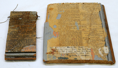
lining board, 1899
These items are from the Heyfield estate in 1899 from the pine lining of the old Orbost School residence which was opposite the school on the corner of Tennyson Street. The Orbost State School opened on 19th of March 1886 .The school had first operated temporarily in a leased building, and on a half-time basis with SS2745 Jarrahmond. The first head teacher was HT Campbell Mackay. However he remained in charge only until 12th of May 1886. The second HT, John Rowe, served until 1908. On 30th of June 1887, a portable room was provided; it being brought to the area by schooner. The school then had accommodation for 30 pupils; the teacher's welfare was considered because quarters of two rooms were attached.This item is part of the history of education in Orbost.Two pieces of pine wood lining boards with newspaper glued on to a blue painted background. 715.1 is the larger if the two pieces. On the larger piece is a tattered label with a hand-written description of the history of the board. The smaller piece has a nail on each side at the top with a piece of string tied to each ( for hanging). orbost-school education-orbost -
 Warrnambool and District Historical Society Inc.
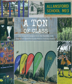
Book, A Ton of Class: 100 favourite recipes from the families and friends of Allansford and District Primary School, 2014
This cookery book was produced in 2014 as a school fundraiser. It was purchased at Allansford Cheese World in January 2015 for $15. Allansford school was established as a National School in 1856 on land reserved for the purpose by John McMahon Allan. It comprised two sandstone classrooms -one for boys and one for girls -with an attached pise teacher's residence. In 1872 when the Victorian Education Department was set up existing schools were listed in alphabetical order and given a number. Allansford State School was No.3. The school was enlarged in the late 1800s and again in the early 1920s. In 1994 following the amalgamation of the Allansford, Allans Forest and Naringal schools a new school was built which adjoined the existing buildings. The old buildings were refurbished as administration and staff facilities. John McMahon Allan settled in the area in 1839 with his brother William Osborne Allan. They were the sons of David Allan, Deputy Commissary General during Macquarie's term of government. The brothers divided the station with William retaining the Allandale portion and John naming his portion Tooram. John McMahon Allan was president of the early district Roads Board. In an attempt to recoup some of the heavy losses due to the disastrous Bateman fire of 1854 John subdivided a portion of Tooram at the Hopkins River crossing known as Allans ford. A school reserve was included in this subdivision. Source: McLeod, Graeme & Barbara. Allansford 1855-2006This book has social and historical interest and significance as it is connected to a local school. It provides a snapshot of food and cooking methods in the early 21st cebturyCookery book with full colour cover featuring 8 photographs and drawings of the Allansford Primary School surrounds and pupil activities on. The images are 'stitched' together with a white zig-zag diamond pattern as if a quilt. The foldout cover has an image of the school's centenary memorial gates and a brief history of the school. Inside the foldout are images of the pupils in each of the school's four team houses. The foldout back cover has full colour images of pupils performing at the school concert. A white strip noting 'our values' is included on the inside back cover foldout. Soft cover, 112 pages.allansford school, a ton of class, allansford primary school, a ton of class recipe book -
 Eltham District Historical Society Inc
Photograph, Peter Pidgeon, Birch Cottage, Eltham-Yarra Glen Road, Christmas Hills, 27 September 2018, 2018
Originally built by John Hill, a shoemaker at Kangaroo Ground around 1878. In the late 1970s when our Society was the Shire of Eltham Historical Society, an offer was made to the Society regarding use of an old cottage at Christmas Hills. The cottage sat beside Watsons Creek just outside the then Shire of Eltham but following municipal restructuring it now lies within the Shire of Nillumbik. For various reasons the offer ultimately lapsed. At that time some research on the cottage was carried out for the Society by Keith Chappel as part of a larger research project that he was doing. Keith’s notes were taken from Lands Department records and showed that the property was the subject of a permissive occupancy of Crown land comprising the creek reserve. In 1903 a Miner’s Right of one acre in area was granted to Edwin Samuel Birch. In 1907 Birch applied to purchase this land but was unable to because it was part of the creek reserve. The documents show that the cottage existed at that time. Upon Birch’s death in 1932, his daughter, Honor Mary Birch was granted a permit to occupy the residence. Honor Mary Birch, known as Nora, was born 1900, the daughter of Edwin Samuel Birch and Honor (nee Young). In 1939 she married George Henry Williams (aka Henry). Honor died 8 July 1976. Her siblings were Margaret Martin (dec), Bert Birch and Brigidene Brinkkotter. In her will she gave and bequeathed “all the improvements on the land held by me at Christmas Hills under Permissive Occupancy from the Department of Land and Survey consisting of the house property thereon and all the contents of the said house to my nephew Brian Joseph Martin of Christmas Hills aforesaid farmer”. The will described the property as a four room, five square house, about 100 years old with enclosed verandah, including kitchen, combined lounge dining room, bedroom and store room; built of ‘bush slabs’ with a corrugated iron roof. A dairy had been erected in 1935. After her death, the property was acquired by the Melbourne Metropolitan Board of Works in 1978. The property is listed on the Victorian Heritage Database HO200-Hill, later Birch farm complex, 945 Eltham-Yarra Glen Road, Watsons Creek and described as: The house has a steep but simply gabled roof form clad with corrugated iron, vertical adzed hardwood slab front wall construction, split palings to the gable ends; rubble freestone chimney at one end (with added gsi flue), pole-framed Graeme Butler & Associates, 2006: 101 Shire of Nillurnbik Planning Scheme Amendment C13 Heritage Assessments verandah (rebuilt?); six-pane double-hung sash windows; T&G bead-edge boarded ledged & braced door; and paling clad rooms added at verandah ends. A slab-clad large fireplace is at the north corner of the house, with a gsi upper cladding added and an internal lining of rubble stone. The rear facade is different construction, being drop-slab, and sits beneath a rear skillion addition to the main gabled form: this may be more recent construction. The house appears to have been once set up for public display and may have been recreated in part for that purpose. Outbuildings are reached by a track along the east side of the house, including what may have been a creamery (typical standard inter-war design clad with corrugated iron and lined with 1938 Lysaght Queens Head Australia galvanised sheet iron) and a paling clad gabled out-house. Timber outbuildings of differing eras are to the north-west of the house, with pole framing and paling infill construction and Redcliffe brand corrugated iron. Post and rail (front) and split paling (rear) fence remnants line the front boundary. Pepper trees part of house yard landscape49 born digital images (includes one panoramic stitch and nine frames from drone video)birch cottage, christmas hills, early settlers, edwin samuel birch, honor mary birch, john hill, watsons creek -
 Eltham District Historical Society Inc
Audio Recording, Audio Recording; 2016-04-14 Jane Woollard and Laughing Waters Road, 14 Apr 2016
April Meeting (Newsletter No. 227, Apr. 2016) At this meeting we are pleased to have as our guest speaker Jane Woollard, who has just published a book titled ‘Laughing Waters Road: Art, Landscape and Memory in Eltham.’ Jane was the local history officer at the Shire of Nillumbik so has a detailed knowledge of the history of our area. She has an extensive background as a writer, theatre director and teacher. As well as directing over 50 productions Jane has been a tutor and guest director at the Victorian College of the Arts and La Trobe University and was Artistic Director of the Union House Theatre at the University of Melbourne. Since 2001 more than eighty artists have been in residence at Laughing Waters in Birrarung House and Riverbend. In her book Jane has woven together their experiences and art making, together with Wurundjeri, European and family histories to create an evocative account of a very special place in Eltham.0:47:13 duration Digital MP3 File 66 MB audio recording, birrarung house, eltham district historical society, jane woollard, laughing waters, riverbend, shire of nillumbik, society meeting, wurundjeri -
 Eltham District Historical Society Inc
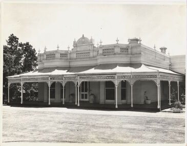
Photograph, Former Eltham Police Residence, 728 Main Road, Eltham, c.1985, 1985c
This photo is believed to have been taken circa 1985 when the Shire of Eltham Parks and Environment occupied the site. This photo was originally mounted on 3mm MDF fibre board with notes and stickers applied as part of a display on the former Police Residence and now present day Local History Centre, home to Eltham District Historical Society; possibly put together by Harry Gilham during his time as president of the society. Eltham Police Station and Residence: A brief history 1860 Eltham Courthouse built in Main Road, together with an adjoining police residence, office, lock–up and stables. 1959 Police Department purchases a house in Pryor Street to be refurbished as Eltham Police Station 1961 Police in Eltham move into Pryor Street refurbished buildings and office. c.1961-1981 Occupied by Vermin and Noxious Weeds Destruction Section of the Department of Crown Lands and Survey. Former Police Station dragged around to rear of Police Residence (prior to August 1967) to make way for the construction of a driveway and access from Main Road. The building was placed on the site of a former Scullery and modified for Lands Department use. 1981 Shire of Eltham take over management of old Police Residence in Eltham. It remains unoccupied for a period of time whilst its future is discussed in Council. 1981-1985 Used for community job creation scheme 1985 Shire of Eltham Parks and Environment occupy the residence. Council improve the driveway but later add a second rear access from Brougham Street due to the dangerous nature of the Main Road entrance. Also add a rear toilet facility between the Police Residence and former Police Station, which was doubling up as a lunch room. Council also commence discussions to re-establish a replica Police Station. c.1986 November. Former Police Station demolished; believed to have been suffering termite damage. c.1989 After some years of discussion a replica Police Station is built, based on photographs, to act as a lunch room and meeting room for Parks and Environment staff and volunteers doing community service. 1996 Eltham District Historical Society in discussions with Nillumbik Shire Council commisioners throughout the year regarding a home for the Society. A proposal put forward by the Society in October to occupy the former Police Residence. 1997 March. Eltham District Historical Society gains access to former Police Residence. 1998 July 12th. Eltham District Historical Society Inc moves into its Local History Centre, 728 Main Road Eltham (the former Police Residnce built in 1860). 2018 July. Eltham District Historical Society gains access to the replica Police Station for use as part of regular heritage tours for schools and community based groups.Colour printHandwritten in faded blue felt pen ink "No. 1 South wall of 728 & back of house built 1860 [1859]. Demolition of weatherboard extension into yard area"728 main road, eltham, local history centre, parks and environment, police residence, police station, shire of eltham -
 Eltham District Historical Society Inc
Photograph, Peter Pidgeon, Dalton Street, Eltham, 2 Aug. 2022
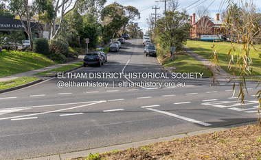
View looking up Dalton Street from near Main Road where the former pond was situated. The pond was drained by Council in 1932 due to concerns of mosquitoes, etc against the wishes of long standing residents such as Thekla Jarrold (39 years) and John Clark (22 years). On the right is the Eltham Primary Schoool No. 209 with the former Headmaster's residence and to the left is Eltham Clinic once the site of the Grant home. Comparison photo: SEPP_0643 In April 1935 the local paper reported on a story where a schoolgirl was talking whilst on her bicycle and it started moving off, flying down Dalton Street and across the main road missing cars and the guy wires for the telephone pole and hurtled 21 feet through the air into the drained pond suffering a broken arm and shock. She was rescued unconscious by John and taken into Mrs Jarrold’s for first aid. This was not the only instance of young girls losing control of bicycles down the hill. Part of a presentation by Peter Pidgeon to the Society, 13 August 2022 showcasing a series of photographs taken by John Henry Clark over the period 1895 to 1930. John Henry Clark was the youngest of three boys born to William Henry Clark (1823-1877) and Maria White (1843-1914). He and his brothers, William Charles Clark (1872-1945), Clement Kent Clark (1874-1912) operated a photography business (Clark Bros.) from 25 Thomas Street, Windsor near Prahran during the period c.1894 to 1914. Following death of Clement in September 1912 and their mother in 1914, the Clark Bros business appears to have dissolved, the premises demolished, and a new house was under construction in 1915. John set up business independently in 1914 operating out of 29 Moor Street, Fitzroy where he is registered in the 1914 and 1915 Electoral Rolls. By 1916 John had relocated to Eltham where he continued his practice as a photographer and took many of the early images around the district of Little Eltham. Around 1930 John changed professions and opened a small cobbler's shop in 1931 near the pond opposite Dalton Street adjacent to the Jarrold family cottage. He never married and continued his profession as a bootmaker from this little shop, maintaining a close relationship with Mrs Jarrold for the rest of their lives. His bootmaker shop remains today beside the Whitecloud cottage and is one of only three remaining shops in the area from the early 20th century.Comparative photo taken 2022 with one taken from same location over 100 years earlier by noted local photographer J.H. ClarkBorn Digitaleltham, j.h. clark photo (2022), dalton street, main road, eltham clinic, eltham primary school, headmaster's residence, state school no. 209 -
 Otway Districts Historical Society
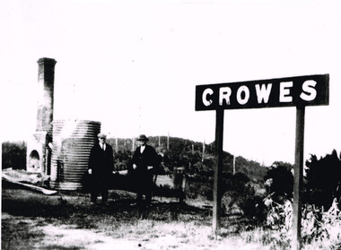
Photograph, Brucker, Crowes after the 1919 fires, 1919
The 1919 bushfire was the worst the area suffered. The fire struck on Saturday afternoon on the 15th February. It destroyed the station at Lavers Hill and Crowes, departmental residences at Lavers Hill and Weeaproinah, the overhead bridges at Beech Forest and Wimba, and damaged the track at various points along the line so that two locomotives became temporarily marooned at Beech Forest.. By the following Tuesday a daily fire relief train had begun operation. By the following Sunday a special train loaded with army tents travelled through to Lavers Hill and deposited most of its consignment there because little remained of this sizeable settlement. An outsider would have had difficulty in picking the place. The letters of the Lavers Hill station nameboard had been burnt although the metal letters survived, and one of the local wags had rearranged them to read "LIARS HELL". By the 1920s water trains were being used to help fight fires, a simple NQR open wagon loaded with the standard 1500 litre square iron water tank.B/W. Crowes station sign, the remains of a chimney, galvanised iron sheet and a water tank, and two men gazing at the camera. Note in the background the clear felling of the timber.crowes; lavers hill; beech forest; weeaproinah; wimba; railways; bushfire; -
 Eltham District Historical Society Inc
Film - Video (VHS), IMP Productions, The Shire of Etham - The Evergreen Shire (Series 69, Item 4), c.1985
Shire of Eltham Archives: Series 69, Item 4 This video was produced for the Shire of Eltham by IMP Productions and provides a description of the shire, 277 square km on a north/northeast axis, some 25 km northeast of the centre of Melbourne with a population of around 40,000. Scenes include Yarra River, rural settings and urban settings, housing estates, Shillinglaw Cottage, Pigeon Bank at Kangaroo Ground, the Eltham Railway Trestle Bridge with reference to the fight by locals in the 1970s to save it from replacement, Montsalvat, mudbrick making and its use as a building material, the use of mudbrick in the Eltham Community Centre blending harmoniously with the environment. Emphasises people living in the area due to the qualities of life provided. Also the Living and Learning Centre, St Andrews Markets and other local markets, the Eltham Leisure Centre, cricket and horse riding at Eltham Lower Park, the Infant Welfare Centre (part of the Eltham War Memorial), how residents are mindful of protecting their historical heritage, the CBA bank and Allwood House at Hurstbridge, Tracey Naughton about the Eltham "As we are" Community Banner project and the “River of Life banner”, the Parks and Gardens office in the former Police Residence building (now the Local History Centre), Alistair Knox Park, road planning and types of roads, tree canopy, Peck's Dam, green carparks, road drainage, Gordon Ford's garden and natural landscapes, and Were Street shops in Montmorency. Planning for shopping facilities and carparks with a population of 40,000 growing to 55,000, Arthur Street Mall and carpark, local village feel in the shopping centre. Councillors and Council staff featured include Mary Grant, Bob Manuell, Rodney Roschellor, John Cohen, Alan Baker. Also scenes of Commercial Place, Diamond Valley Railway, Eltham Galley, Riverclay and canoeing on the Yarra intermingled with images of the shire from the Shire of Eltham Pioneers Photograph collection.VHS Video cassette Converted to MP4 file format 00:11:56; 79MBshire of eltham, video recording, shire of eltham archives, alistair knox park, allwood house, arthur street, arthur street mall, bob manuell, canoeing, carparks, cba bank, commercial place, council staff, councillors, cr. mary grant, cricket, diamond valley railway, eltham community banner project, eltham community centre, eltham galley, eltham leisure centre, eltham living and learning centre, eltham lower park, eltham railway trestle bridge, eltham war memorial, gordon ford garden, horse riding, housing estates, hurstbridge, infant welfare centre, john cohen, kangaroo ground, local history centre, montmorency, montsalvat, mudbrick, parks and gardens, peck's dam, pigeon bank, police residence, river of life banner, riverclay, road drainage, road planning, rodney roschellor, shillinglaw cottage, shire of eltham pioneers photograph collection, st andrews market, tracey naughton, tree canopy, were street, yarra river, alan baker