Showing 558 items
matching barkers road
-
 Kew Historical Society Inc
Equipment - Sports Equipment, Auburn Heights Recreation Club, Wooden Croquet Mallet, Twentieth Century
... at the Auburn Heights site in Barkers Road, forming the Kew Heights... at the Auburn Heights site in Barkers Road, forming the Kew Heights ...Sports Clubs in Kew in the final decades of the 19th century and in the early 20th century were often umbrella organisations with facilities for a number of sports. Typically in Kew, this included teams in lawn bowls, tennis and croquet. The Kew Bowling Club was formed in 1880 while the privately owned Auburn Heights Recreation Club was opened in 1904. The croquet courts at the Kew Recreation Club were opened in 1906, two years after the Club's formation. By 1998, the two Clubs decided to amalgamate at the Auburn Heights site in Barkers Road, forming the Kew Heights Sports Club. The combined club was itself taken over by the Melbourne Cricket Club in 2012 becoming MCC Kew Sports Club. In 2017 MCC Kew closed and its landholding was subsequently sold to Carey Baptist Grammar School. Both the Kew and Auburn Heights Clubs assembled important collections. These historically significant and large collections were donated to the Society in 2020. The collections include manuscripts, pictures, trophies, plans, honour boards etc. References Barnard FGA 1910, 'Sports and Pastimes' in Jubilee History of Kew Victoria: Its origin & progress 1803-1910. Chapman J & C 1999, The history of the Auburn Heights Recreation Club, 1904 to 1908. Reeve S 2012, City of Boroondara: Thematic Environmental History, p.216.The combined collections of the four sporting clubs making up the collection number hundreds of items that are historically significant locally. They are also significant to the sporting history of the greater Melbourne area and to the sports of lawn bowls and tennis in Australia in the 19th and 20th centuries. The collection illuminates two of the Victorian historic themes - 'Building community life' through forming community organisations and 'Shaping cultural and creative life' by participating in sport and recreation.Croquet mallet, Shaft made of a number of separate rectangular sections of pale wood, mostly wrapped with cotton cord and strips of leather. The rectangular head is made of a darker heavier wood and it is banded with a strip of lighter wood.croquet -- mallets, croquet -- equipment, auburn heights croquet club, auburn heights recreation club -
 Kew Historical Society Inc
Plan, Melbourne & Metropolitan Board of Works : Borough of Kew : Detail Plan No.1296, 1904
... fronting Barkers Road and brick and weatherboard villas in Foley... development was characterised by larger houses fronting Barkers Road ...The Melbourne and Metropolitan Board of Works (MMBW) plans were produced from the 1890s to the 1950s. They were crucial to the design and development of Melbourne's sewerage and drainage system. The plans, at a scale of 40 feet to 1 inch (1:480), provide a detailed historical record of Melbourne streetscapes and environmental features. Each plan covers one or two street blocks (roughly six streets), showing details of buildings, including garden layouts and ownership boundaries, and features such as laneways, drains, bridges, parks, municipal boundaries and other prominent landmarks as they existed at the time each plan was produced. (Source: State Library of Victoria)This plan forms part of a large group of MMBW plans and maps that was donated to the Society by the Mr Poulter, City Engineer of the City of Kew in 1989. Within this collection, thirty-five hand-coloured plans, backed with linen, are of statewide significance as they include annotations that provide details of construction materials used in buildings in the first decade of the 20th century as well as additional information about land ownership and usage. The copies in the Public Record Office Victoria and the State Library of Victoria are monochrome versions which do not denote building materials so that the maps in this collection are invaluable and unique tools for researchers and heritage consultants. A number of the plans are not held in the collection of the State Library of Victoria so they have the additional attribute of rarity.Original survey plan, issued by the MMBW to a contractor with responsibility for constructing sewers in the area identified on the plan within the Borough of Kew. The plan was at some stage hand-coloured, possibly by the contractor, but more likely by officers working in the Engineering Department of the Borough and later Town, then City of Kew. The hand-coloured sections of buildings on the plan were used to denote masonry or brick constructions (pink), weatherboard constructions (yellow), and public buildings (grey). This area was once known as O’Shaughnessy’s Paddock. O’Shaughnessy was the licensee of the Kew Hotel. The ‘Paddock’ or farm was for many years the closest farm to Melbourne. By 1903, when this plan was surveyed and lithographed, little of the farm remained. The area is dominated by a ‘clay hole’, on the site of the current Foley Reserve. It was used by Smart’s Brickyard from the 1880s until 1911, when the Council purchased it for a rubbish dump. It is notable as the site is one of the few industrial operations to have existed in Kew. By 1903, urban development was characterised by larger houses fronting Barkers Road and brick and weatherboard villas in Foley Street. Nearer the pit, weatherboard houses predominated. Foley Street bisected the triangular block and continued right to Denmark Street. At this stage, a house impeded the through road, only allowing access via a right of way to High Street.melbourne and metropolitan board of works, detail plans, mmbw 1296, cartography -
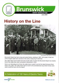 Melbourne Tram Museum
Newsletter, Yarra Trams, Century of Electric Trams, Jun. 2006
... Ormond. .6 - Kew - photo of the Barkers Road cutting 1965 .7... Ormond. .6 - Kew - photo of the Barkers Road cutting 1965 .7 ...Set of 8 newsletters issued June 2006 for each tram depot, featuring a historical overview of the depot based around the "Century of Electric Trams". Front page has a historic photo of the depot or nearby, a message from the manager, thanks to Good Friday appeals, Anzac Day report, note about safety and some personnel notes for the depot itself.\ .1 - Brunswick - - opening photo of the Coburg line 1916 with a note about the cable trams. .2 - Camberwell - history at the junction - Camberwell Junction 1954 and a note on HTT. .3 - Essendon - photo of staff and officers (not in uniform) out the front of the depot - post WW1 .4 - East Preston - photo of 1000 outside depot - brand new, with notes on St Georges Road and cable. .5 - Glenhuntly - History on the line - opening of the Glenhuntly Esternwick in 1913 and Point Ormond. .6 - Kew - photo of the Barkers Road cutting 1965 .7 - Malvern - opening photo of 1910. .8 - Southbank - photo of 376 at the old South Melbourne depot while being built. List of people photographed or noted shown in Key Associations - where surname given. Some photo captions and notes only have the first name. Second copy of each item added 11-3-2018 from donation of Hugh Waldron.trams, tramways, yarra trams, 100 years of electric trams, centenary, brunswick, camberwell, essendon, east preston, glenhuntly, kew, malvern, southbank -
 Kew Historical Society Inc
Plan, Melbourne & Metropolitan Board of Works : Borough of Kew : Detail Plan No.1297, 1904
... bounded by Barkers Road, High Street and Stevenson Street. Because...). This plan of Kew encompasses the area bounded by Barkers Road, High ...The Melbourne and Metropolitan Board of Works (MMBW) plans were produced from the 1890s to the 1950s. They were crucial to the design and development of Melbourne's sewerage and drainage system. The plans, at a scale of 40 feet to 1 inch (1:480), provide a detailed historical record of Melbourne streetscapes and environmental features. Each plan covers one or two street blocks (roughly six streets), showing details of buildings, including garden layouts and ownership boundaries, and features such as laneways, drains, bridges, parks, municipal boundaries and other prominent landmarks as they existed at the time each plan was produced. (Source: State Library of Victoria)This plan forms part of a large group of MMBW plans and maps that was donated to the Society by the Mr Poulter, City Engineer of the City of Kew in 1989. Within this collection, thirty-five hand-coloured plans, backed with linen, are of statewide significance as they include annotations that provide details of construction materials used in buildings in the first decade of the 20th century as well as additional information about land ownership and usage. The copies in the Public Record Office Victoria and the State Library of Victoria are monochrome versions which do not denote building materials so that the maps in this collection are invaluable and unique tools for researchers and heritage consultants. A number of the plans are not held in the collection of the State Library of Victoria so they have the additional attribute of rarity.Original survey plan, issued by the MMBW to a sewage contractor with responsibility for constructing sewers in the area identified on the plan within the Borough of Kew. The plan was at some stage hand-coloured, possibly by the contractor, but more likely by officers working in the Engineering Department of the Borough and later Town, then City of Kew. The hand-coloured sections of buildings on the plan were used to denote masonry or brick constructions (pink), weatherboard constructions (yellow), and public buildings (grey). This plan of Kew encompasses the area bounded by Barkers Road, High Street and Stevenson Street. Because of the angle created by High Street, a number of houses on the northern side of High Street are shown. The area is dominated by one of the great original landholdings in Kew, described here as the ‘Findon Paddock’. ‘Findon’, the house from which the name of the paddock was taken fronts Stevenson Street and was clearly a rambling structure. The best-known occupant of Findon was Henry ‘Money Miller’ who bought the house in 1871. Miller was a member of Victoria’s first parliament and assisted in the framing of its constitution. Findon was to be subdivided as early as 1912, when the Findon Subdivision was advertised to be sold by auction. In the plan of the subdivision, the original house is not shown, so, presumably it had previously been demolished. Fincham & Son moved the organ, built by Henry Willis, which was installed in the house, first to ‘Whernside’ in Toorak, and later to the Box Hill Methodist Church.melbourne and metropolitan board of works, detail plans, mmbw 1297, cartography, kew (vic.) — municipal collection -
 Kew Historical Society Inc
Plan, Melbourne & Metropolitan Board of Works : Borough of Kew : Detail Plan No.1573, 1905
... , including ‘Fairlawn’ in Barkers Road, and ‘Clevedon’ and ‘Rosehill..., including ‘Fairlawn’ in Barkers Road, and ‘Clevedon’ and ‘Rosehill ...The Melbourne and Metropolitan Board of Works (MMBW) plans were produced from the 1890s to the 1950s. They were crucial to the design and development of Melbourne's sewerage and drainage system. The plans, at a scale of 40 feet to 1 inch (1:480), provide a detailed historical record of Melbourne streetscapes and environmental features. Each plan covers one or two street blocks (roughly six streets), showing details of buildings, including garden layouts and ownership boundaries, and features such as laneways, drains, bridges, parks, municipal boundaries and other prominent landmarks as they existed at the time each plan was produced. (Source: State Library of Victoria)This plan forms part of a large group of MMBW plans and maps that was donated to the Society by the Mr Poulter, City Engineer of the City of Kew in 1989. Within this collection, thirty-five hand-coloured plans, backed with linen, are of statewide significance as they include annotations that provide details of construction materials used in buildings in the first decade of the 20th century as well as additional information about land ownership and usage. The copies in the Public Record Office Victoria and the State Library of Victoria are monochrome versions which do not denote building materials so that the maps in this collection are invaluable and unique tools for researchers and heritage consultants. A number of the plans are not held in the collection of the State Library of Victoria so they have the additional attribute of rarity.Original survey plan, issued by the MMBW to a contractor with responsibility for constructing sewers in the area identified on the plan within the Borough of Kew. The plan was at some stage hand-coloured, possibly by the contractor, but more likely by officers working in the Engineering Department of the Borough and later Town, then City of Kew. The hand-coloured sections of buildings on the plan were used to denote masonry or brick constructions (pink), weatherboard constructions (yellow), and public buildings (grey). This plan has detailed annotations written in red or blue ink, showing prices, which may be the annual valuations of the properties, and some owners’ names, a most unusual feature on contractor's maps. Some areas, such as the buildings of Methodist Ladies’ College (MLC), include the school’s tennis court and swimming pool, but are not coloured to show building materials – did the draftsman just run out of time, or ink, or enthusiasm, before his plan had to be submitted? MLC had been founded in 1882 as a ‘modern school of the first order’ with buildings that formed ‘a collegiate institution for girls unsurpassed in the colonies’. The goal of its founders was to provide a high-class Christian education for girls, comparable with that provided elsewhere for boys. Some shops are shown along Edgevale Road, though they are not designated as commercial premises. Larger houses are depicted, including ‘Fairlawn’ in Barkers Road, and ‘Clevedon’ and ‘Rosehill’ (now demolished) in Fitzwilliam Street.melbourne and metropolitan board of works, detail plans, mmbw 1573, maps - borough of kew, cartography -
 Kew Historical Society Inc
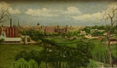
Painting - Panoramic View of Kew and Abbotsford from the garden of Rockingham, V Maloney, 1952
... to the south by the Barkers Road cutting, and to the north... to the south by the Barkers Road cutting, and to the north ...The extensive formal landscaped gardens of Rockingham had been created in the 1860s, and by the 1950s remained bordered to the south by the Barkers Road cutting, and to the north by Blytheswood, the neighbouring Syme family property, By 1940, the Syme family were no longer the occupiers of Rockingham. John Herbert Syme had died in October 1939, and by August the following year, his wife had made the house and garden available, rent free to the Red Cross as a convalescent home for Australian soldiers injured in the Second World War. At the time, the house was described as containing twenty rooms, including a ballroom and a billiards room, with a garden of eight acres overlooking the Yarra. The task of renovating the house to conform to its new function as a convalescent home took a year, finally opening in August 1941. Community support for Rockingham was widespread and included the decision by the National Gallery of Victoria to loan pictures from its collection to decorate the walls. Calls were made for women around Victoria to donate fruit and vegetables from their gardens, which the railways agreed to freight for free. Other local support included the work by a team of boys to establish a three-acre vegetable garden within the formal terraced gardens. From the beginning, occupational therapy formed a key component of the rehabilitation of psychologically injured soldiers. This is confirmed by contemporary newspaper accounts of weaving, ironwork, leatherwork, basketry and gardening by patients. Numerous photographs, held by the Australian War Memorial (AWM) and the State Library of Victoria (SLV), record the importance of these rehabilitation activities. The painting of the view across the river to Abbotsford may have been painted in one of these occupational therapy sessions. For many decades it hung in the occupational therapy room. It must have been on view following the sale of Rockingham by the Syme family to the Red Cross in 1955, and subsequently, until the house was demolished and its grounds finally subdivided in 1977.View of Abbotsford from the garden of Rockingham (1952) was created by V Maloney. The vantage point of the artist was the garden of Rockingham, one of two mansions overlooking the Yarra owned by the Syme family. The artwork depicts a number of sites - especially factories - that have since been demolished.Signed by the artist, lower right "V Maloney"rockingham red cross convalescent home, hospitals - kew (vic), rosemary lade, art therapy -
 Kew Historical Society Inc
Plan, Borough of Kew Detail Plan No.1577, 1904
... not yet reach Barkers Road. Roxeth is one of a number of Henty... Barkers Road. Roxeth is one of a number of Henty houses in Kew ...The Melbourne and Metropolitan Board of Works (MMBW) plans were produced from the 1890s to the 1950s. They were crucial to the design and development of Melbourne's sewerage and drainage system. The plans, at a scale of 40 feet to 1 inch (1:480), provide a detailed historical record of Melbourne streetscapes and environmental features. Each plan covers one or two street blocks (roughly six streets), showing details of buildings, including garden layouts and ownership boundaries, and features such as laneways, drains, bridges, parks, municipal boundaries and other prominent landmarks as they existed at the time each plan was produced. (Source: State Library of Victoria)This plan forms part of a large group of MMBW plans and maps that was donated to the Society by the Mr Poulter, City Engineer of the City of Kew in 1989. Within this collection, thirty-five hand-coloured plans, backed with linen, are of statewide significance as they include annotations that provide details of construction materials used in buildings in the first decade of the 20th century as well as additional information about land ownership and usage. The copies in the Public Record Office Victoria and the State Library of Victoria are monochrome versions which do not denote building materials so that the maps in this collection are invaluable and unique tools for researchers and heritage consultants. A number of the plans are not held in the collection of the State Library of Victoria so they have the additional attribute of rarity.Original survey plan, issued by the MMBW to a contractor with responsibility for constructing sewers in the area identified on the plan within the Borough of Kew. The plan was at some stage hand-coloured, possibly by the contractor, but more likely by officers working in the Engineering Department of the Borough and later Town, then City of Kew. The hand-coloured sections of buildings on the plan were used to denote masonry or brick constructions (pink), weatherboard constructions (yellow), and public buildings (grey). MMBW Plan No.1577 includes some of the most significant houses in Kew: Herbert Henty’s ‘Roxeth’ (now part of Trinity Grammar), ‘Butleigh Wooton’, ‘Bokara’ and ‘Harrow’. It also includes the streets that have since changed their names. That part of College Parade linked to Glenferrie Road is now named College Place, College Parade now extends further north, and Charles Street did not yet reach Barkers Road. Roxeth is one of a number of Henty houses in Kew. Herbert Henty made his home here and was elected a member of Kew Municipal Council in 1864 and mayor in 1868-69. Walter Henry Serle, of Harrow served in the First World War. He was awarded the Military Medal ‘’For conspicuous bravery and devotion to duty. On 29th September near BELLICOURT he showed the greatest bravery and determination when his platoon was attacked by enemy bombing parties. It was due largely to his personal efforts that all the attacks were repulsed. Until wounded, his utter disregard of personal safety and boldness in dealing with the attacks were the means of saving the situation and were an inspiring example to his men.’melbourne and metropolitan board of works, detail plans, maps - borough of kew, mmbw 1577, cartography -
 Kew Historical Society Inc
Plan, Melbourne & Metropolitan Board of Works : Borough of Kew : Detail Plan No.1563, 1905
... ). This plan covers the area between Barkers Road, Wrixon Street... Barkers Road, Wrixon Street, Sackville Street and Brougham Place ...The Melbourne and Metropolitan Board of Works (MMBW) plans were produced from the 1890s to the 1950s. They were crucial to the design and development of Melbourne's sewerage and drainage system. The plans, at a scale of 40 feet to 1 inch (1:480), provide a detailed historical record of Melbourne streetscapes and environmental features. Each plan covers one or two street blocks (roughly six streets), showing details of buildings, including garden layouts and ownership boundaries, and features such as laneways, drains, bridges, parks, municipal boundaries and other prominent landmarks as they existed at the time each plan was produced. (Source: State Library of Victoria)This plan forms part of a large group of MMBW plans and maps that was donated to the Society by the Mr Poulter, City Engineer of the City of Kew in 1989. Within this collection, thirty-five hand-coloured plans, backed with linen, are of statewide significance as they include annotations that provide details of construction materials used in buildings in the first decade of the 20th century as well as additional information about land ownership and usage. The copies in the Public Record Office Victoria and the State Library of Victoria are monochrome versions which do not denote building materials so that the maps in this collection are invaluable and unique tools for researchers and heritage consultants. A number of the plans are not held in the collection of the State Library of Victoria so they have the additional attribute of rarity.Original survey plan, issued by the MMBW to a contractor with responsibility for constructing sewers in the area identified on the plan within the Borough of Kew. The plan was at some stage hand-coloured, possibly by the contractor, but more likely by officers working in the Engineering Department of the Borough and later Town, then City of Kew. The hand-coloured sections of buildings on the plan were used to denote masonry or brick constructions (pink), weatherboard constructions (yellow), and public buildings (grey). This plan covers the area between Barkers Road, Wrixon Street, Sackville Street and Brougham Place, much of it now occupied by Carey Baptist Grammar and Preshil schools. This was an area of large and prestigious homes in 1903, some with formally laid-out gardens, such as ‘Tower Hill’ and ‘Opawa’. ‘Kalimna’ was built in 1890-91 for William H. Jarman, an accountant, and ‘Blackhall’ at the same time for W.H. Roberts. Blackhall was to be acquired by the Salvation Army in 1915 and renamed ‘Catherine Booth Girls’ Home’. The Home accommodated girls, aged between 4 and 16. Kalimna and Blackhall are of significance as typical and intact late Victorian mansions and as such are two key Victorian buildings to have been built in Kew. Both Blackhall and Kalimna are now part of Preshil. ‘Fairview’ was for a long time occupied by the Sisters of St. Joseph of Cluny as a care home for the elderly, but it is now part of Carey Grammar School, as are the grounds of ‘Wagga Merne’, ‘Weemutta’, ‘Blakely’, ‘Daheim’ and ‘Mildura’ (later ‘Urangeline’), the last being particularly impressive in 1903, with a tennis court, conservatory, outhouses, and two bathrooms!melbourne and metropolitan board of works, detail plans, mmbw 1563, cartography -
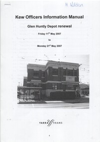 Melbourne Tram Museum
Manual, Yarra Trams, "Glen Huntly Depot Renewal", "Kew Depot - Pit Deepening Roads 1 to 4", "Camberwell Depot Yard Tracks Renewal", 2007 to 2011
... / Barkers Road entrance and High Street and Cotham Road - dated 25... / Barkers Road entrance and High Street and Cotham Road - dated 25 ...Set of three Reports or Operations Plan or Manual for work at Kew and Glen Huntly Depots. .1 - 12 A4 pages - stapled - "Kew Officers Information Manual - Glen Huntly Depot renewal" - Friday 11 May 2007 to Monday 21st May 2007". Has a photo of the depot on the front sheet. Covers service changes, arrangements for changes to services running from Kew Depot, car parking, tram requirements. Has a table of contents. .2 - 7 A4 pages - stapled - "Operations Plan - "Kew Depot - Pit Deepening Roads 1 to 4" = Monday 23 June 2008 to Friday 18 July 2008" - has a table of contents, covers maintenance, tram requirements, out stabling, security, sanding and hours of operation. .3 - 19 A4 pages - stapled - "Camberwell Depot Yard Tracks Renewal" - Saturday 3 December 2011 to Monday 12 December 2011 - has a table of contents, service changes, car parking, stabling, maintenance, operations, sanding, cleaning, rosters and test trams and notice to employees. .4 - 3 A4 foolscap sheets - Co-ordinating plan for Kew Depot / Barkers Road entrance and High Street and Cotham Road - dated 25/11/2005 - list works, location, overhead, cabling, track and other works and isolation requirements. On the rear has a list of the trams for the depot, Collins St, Simpson St and Camberwell. .5 - Notes on the Kew Depot relay by Hugh Waldron received in an email dated 9/3/2018 - from Kew Depot History..1 - Has "H. Waldron" in top left hand corner in blue ink. .2 - ditto "Hugh" in red ink.trams, tramways, yarra trams, kew depot, glenhuntly tram depot, trackwork, depot fan, tram services -
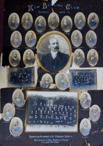 Kew Historical Society Inc
Photograph, Kew Bowling Club, Runners up for Pennant and for Championship Rink; Office Bearers of Club and Members of Pennant and Champion Rink Teams, 1908-9
... , 59 Sackville Street, Kew - NIVEN Henry N, 192 Barkers Road..., 59 Sackville Street, Kew - NIVEN Henry N, 192 Barkers Road ...The Kew Bowling Club was formed in 1880 and merged with Auburn Heights Recreation Club in 1998. In addition to the unnamed members of the teams, the following individuals are profiled on the item. The background of these men has been identified by John Torpey as follows: BRADSHAW William Henry, grocer, 6 Cotham Road, Kew & 33 Prospect Hill Road, Camberwell - CARNEGIE J Lewis, merchant, Studley Avenue, Kew [Carnegie & Sons, piano & organ importers 106 Elizabeth Street, Melbourne] - CLARKE Charles, warehouseman, 35 Queen Street, Kew - EDGAR Robert McCutcheon, 215 High Street, Kew - FINLAYSON John Marshall, solicitor, 178 Cotham Road, Kew - GREEN Charles Henry, clerk, 81 Wellington Street, Kew - GREENHILL F snr [not found] - GREENHILL Thomas jnr, traveller, High Street south, Kew - HAMBLETON Lincoln, civil servant, 32 Coleridge Street, Kew - HANDBURY John, manufacturer, 55 Walpole street, Kew - JELLIS Thomas G, baker, Princess Street, Kew - LILBURN William Hugh solicitor, Denmark Street, Kew - MANSFIELD Allan, plumber, 150 Cotham Road, Kew [S&McD] or 21 Belmont Avenue, Kew [Electoral Roll 1909] - NATHAN Simeon, warehouseman, 59 Sackville Street, Kew - NIVEN Henry N, 192 Barkers Road, Kew [FW Niven & Co 40-42 Flinders Street, Melbourne, printers & lithographers] - SIMONTON Alan Thompson, dairyman, Belmont Avenue, Kew - SINUCH WC [not known – bottom right of frame] - SWINBURNE George [see Australian Dictionary of Biography] - TREDENNICK William, civil servant 285 Tennyson Street, Kew - WENTWORTH William Dalton, painter, 5 Derrick Street, Kew - WOOLLARD Thomas, civil servant, Hildebrand Crescent, Hawthorn - WOOLLARD Walter Herbert, builder, 35 Disraeli Street, Kew [Sources: Sands & McDougall directories, Electoral Roll 1909]The photographic collage is historically important as it includes rare photographs of local identities, many of whom were significant civic actors statewide.Large photo collage created by Barroni & Co (Melb) of team, player and official portraits of members of the Kew Bowling Club. At one stage the item was in a drawer in a map cupboard, fractured into multiple pieces. The items were later assembled some years ago Graham Lindsay and framed in 2021 for exhibition by John Torpey. "Kew Bowling Club / Season 1908-9 / Runners up for pennant and for Championship Rink / Office bearers of Club and Members of Pennant and Champion Rink Teams".kew bowling club -
 Kew Historical Society Inc
Archive (series) - Subject File, Authors (Kew), 1958
... the headquarters of the Fellowship of Australian Writers (1/317 Barkers... the headquarters of the Fellowship of Australian Writers (1/317 Barkers ...Various PartiesReference, Research, InformationKHS OrderReference file containing Sundry information about authors (poets, novelists, playwrights, historians, politicians, journalists) who were born, educated, lived or died in Kew, initially compiled by Society member Elizabeth Mackie who had previously researched the artists of Kew. Since the file was created, various items including correspondence and newspaper articles/cuttings have been added. Some information relates to organisations rather than individuals, such as that Kew was once the headquarters of the Fellowship of Australian Writers (1/317 Barkers Road). Within the file there is correspondence and curriculum vitae supplied by: Allan Aldous, Lillian Wood, Michele Nayman (1981), Yetta Rothberg (1981), Judith Rodriguez (1981), Rev Dr Arthur de Quetteville Robin (1982). The File also includes a photocopy of a letter supplied by Prof A D Hope (1981) relating to his memories of Kew. Authors mentioned in the file include: Allan Aldous, F G A Barnard, James Bonwick, Martin Boyd, Vincent Buckley, Sir Macfarlane Burnet, Anne M Carson, John Clements, Rita Erlich, Barbara Giles, Alison Goding, A D Hope, Wendy Jacobs, Lally Katz, Jill Manton, Philip Martin, James McAuley, Pauline McKinnon, Philip Mendez, Marrion Miller, Michele Nayman, Brenda Niall, Mark O’Connor, Nettie Palmer, Vance Palmer, Rev Dr Arthur de Quetteville Robin, Judith Rodriguez, Myra Roper, Dorothy Rogers, Yetta Rothberg, Frederick Sinnett, John Stanley, Peter Steele, W D Vaughan, Gwen Walker, J M Walsh, Lillian Wood.authors - kew (vic)authors - kew (vic) -
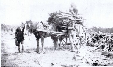 Harcourt Valley Heritage & Tourist Centre
photograph, Cutting timber
... wood'. Peeler's Road, Barkers Creek. Photographed by Alice...-load of 'five-foot wood'. Peeler's Road, Barkers Creek ...Ken Peeler (at head of horse), Ken's father, Ern Peeler and brother Don Peeler (sitting on load) with dray-load of 'five-foot wood'. Peeler's Road, Barkers Creek. Photographed by Alice 'Girlie' Adams, approx. 1942. Families living at Barkers Creek and Woodbrook obtained contracts to supply 'five foot wood' to Thompson's Foundry and Castlemaine Woollen Co. Rows of wood, neatly stacked, 10’ high X 5’ wide covered many acres at each factory, ready for use in firing the boilers. Much bushland was thus cleared for orchard or pasture. The horse depicted is fully harnessed with bridle, eye-winkers and reins, dray collar, hames, shaft saddle with girth & pole straps and breeching straps. Neatly stowed under the dray shafts can be seen the props, used to keep the dray horizontal when the horse was to be taken out of the shafts. The dray was almost entirely constructed of wood, with steel tyres on the wheelsA reminder of the significance of local sources of fuel to some of Victoria’s biggest manufacturing concerns as well as depicting a major source of employment involving minimal capital. A B&W photograph depicting 2 men and a boy with a horse-drawn dray filled with wood. Photograph taken by Alice 'Girlie' Adams in 1942. Ken Peeler, Ern Peeler and Don Peeler appear in the picture along with a horse with no known name. -
Ringwood and District Historical Society
Name List, A suggested list of names suitable for streets in Ringwood, and showing origin of name - compiled 1970, c.1970
A suggested list of names suitable for streets in Ringwood, and showing origin of name. Two pages foolscap, 100 names approx. ; Hull: Surveyed Gippsland Road now Maroondah Highway, 1855 (Also name of roar in Croydon); Darke, Wm Wedge, Surveyed all land between Yarra and Western Port, including Ringwood - 1843; Wedge, Chas. Nephew of John Helder Wedge, Batman's surveyor, 1834. Active in Ringwood East Progress Association over 40 years ago.; "Barker's Track" - forerunner of Gippsland Road, Maroondah Highway.; Bickford, N Superintendent of Hodgkinson's Field Party of Surveyors etc. Original Land Owners; Isaacs,S. G. Bought first land in Ringwood - March 1858 - Lot 3; Moss, M.Lot 1 - April 1858; Davis, J. Lot 6 - April 1858; Riley, P. Lot 11 - April 1858; Marks, M.Lot 15 - November 1858; Wieland, C.F. Lot 14b - July 1872; Richter, K.H. Lot 14a - April 1869; Molloy, J. Lot 21 - December 1877; Watson, B. Lot 22a - April 1869; Stutt, W. Lot 27 - June 1884; Blood, R & W.Lot 42-3 - March 1872; Cox, J. Lot 41 - March 1870; Moncrieff, T.Lot 40a - September 1876; Pett, J. Lot 40b - January 1878; Feltham, F. Lot 28a - September 1881; Downing, J.J.Lot 32b - October 1881; Burge, W. Lot 39 - April 1875; Axford, W. Lot 32a - December 1877; Ball, E.A.Lot 37 - March 1869; Parker, G. Lot 28 - June 1882; Gangell, W.Lot 24a - January 1883; Hodgson, A.D. Lot 25a - May 1875; Muldowney, P. Lot 30d - June, 1877; Hosie, J.S. Lot 34, 30b - June 1878; Rourke, H.Lot 36 - July 1869; Duggan, T.Lot 35 - May 1870; Pach, W. Lot 30e - May 1884; Morris, J. Lot 25b - June 1882; Kleinert, A. Lot 29c - August 1886 +Additional Keywords: Hull / Darke, Wm Wedge / Wedge, Chas / Wedge, John Helder / Bickford, N -
 Ringwood and District Historical Society
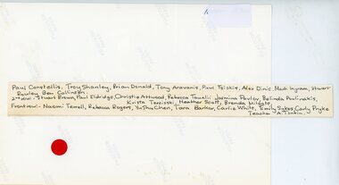
Photograph, Ringwood Primary School -Grade 2 1986
Colour photographRingwood State School Names (1986) Grade 2 Back Row- L to R: Paul Constellis, Troy Shanley, Brian Donald, Tony Aravanis, Paul Tsiokis, Alex Dinic, Mark Ingram, Stuart Rowley, Ben Collinson 2nd Row- L to R: Stuart Brown, Paul Eldridge, Christie Attwood, Rebecca Tauslii, Jasmina Pavlov, Belinda Poulinakis, Krista Terzioski, Heather Scott, Brenda Milgate Front Row- L to R: Naomi Terrell, Rebecca Rogers, YuShu Chen, Tara Barker, Carlie White, Emily Sykes, Carly Pryke. Teacher A.Tonkin. -
 Warrnambool and District Historical Society Inc.
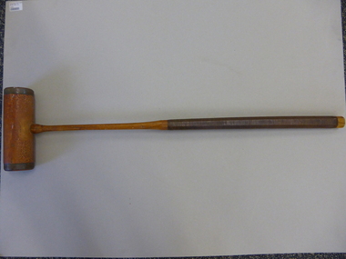
Mallet, Croquet Mallet, Late 19th century/early 20th century
This croquet mallet belonged to Martha Beatrice McCullough (nee Barker), wife of George McCullough, who died in November 1931 at the age of 50. She lived at the house at 113 Koroit Street named ‘Heatherlie’ (the site of the current retirement residential units) and owned and managed the Silver Stream Café in Liebig Street. The mallet was used by her and may have been used by her mother before her. Croquet was a popular sport, especially for women after the 1880s. This is a significant item as it is an artefact associated with women’s sport in the late 19th century and early 20th century. It is also important as it belonged to a local Warrnambool resident and businesswoman whose granddaughter resides in Warrnambool today.This is a brown-coloured wooden croquet mallet. The handle has ribbed leather binding and the mallet has brass edging and brass on the under section attached with twelve brass screws. The handle is octagonal shaped. The lower section of the handle and the mallet have been varnished. On the mallet: ‘The Reel’croquet, warrnambool -
Glen Eira Historical Society
Document - Elsternwick Congregational Church – Caulfield Union Church
Souvenir programme of the Elsternwick Congregational Church Welcome Home Social for their members, who served in World War 1, held on 05/05/1919 at the church. Includes a photograph of church exterior. A programme for the Combined Welcome Social for the new pastor Rev. J.S. Griffiths held on 09/12/1919. The twenty-seventh annual report of Elsternwick Congregational Church for year ending 30/06/1921. Pamphlet for jubilee celebration for Elsternwick Congregational Church in August 1944. Includes programme of events and brief history of the church. Programme for fifty-first church anniversary and social held on 12/08/1945 and 15/08/1945. Undated church letterhead sheet of paper. Includes exterior photograph of the church. Four church newsletters from March 1973, March 1975, February 1977 and May 1977. Three black and white photographs, undated and photographer unknown, of church exterior, Pilots’ Club and Sunday School children.elsternwick congregational church, world war 1914-1918, butters r.w., elliot t., hale w.r., christiansen a.l.a., thoms f.e., emmerson j.h., angwin h.h., white s.j., anderson g., wragge l.g., adams g.h., smith e.j., thoms s.e., anderson j., wragge t.w.e, emmerson e., cleghorn h., lindsay g.j., fullagar w.k., barker j.n., snowball g.f., clarke r., wragge s., joynes a., lewis r., griffith j. shaw rev., griffith mrs., bryant samuel rev., christiansen w. rev, slatter j.c., robertson w., clarke w., forward f.a. rev., orrong road, king street, curral road, hoddle street, elizabeth street, robertson r.j., pedler b.r., hoare j.g., lewis g.n., tytherleigh r. j., watts v., message h.t., barlow c.w., northey j.d. rev., krohn f.w. rev, swan e.f.w. rev., riddles f.j. rev., elsternwick, caulfield north, hatley l., hatley l. mrs., parkside street, langdon bob rev., bendelack i., sandham court, mcloghlin j.r., prahran grove, smitham nancy, religious groups, sunday schools, congregational church, newsletters, st. john’s uniting church elsternwick, strickland a. mrs., watts w.c. mrs., mcivor miss, watts t. mr., watts t. mrs., watts r. miss, anderson a. mr., white miss, white c. miss, white p. miss, gladman f.e. mr., glandman f.e. mrs., slatter h.t. mr., slatter h.t. mrs., boldner a. mr., boldner a. mrs., smith s.a. mrs., strickland a. mr., owen w. mr., owen w. mrs., woodward t. mr., gregson j.b. mr., shippey f.l. mr., turner c. mr., turner c. mrs., blanch j.w. mr., blanch j.w. mrs., pye h. mr., pye h. mrs., haynes m.j. mrs., burgess e. mr., burgess e. mrs., watts h. g. miss, burgess a.s. mr., burgess a.s. mrs., watts m. miss, thoms w. mr., thoms h. mr., thompson j.m. mrs., thompson miss, grover e. miss, slatter h.h. mr., slatter r. miss, anderson a. miss, thoms e.m. mrs., newson m. mrs, legge mrs., legge f. miss, legge b. miss, young mrs., young miss, copland o. rev., copland o. mrs., steed mr., steed mrs. -
 Glen Eira Historical Society
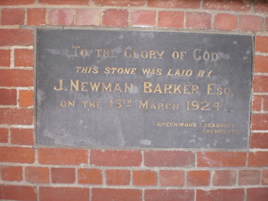
Document - Gardenvale Congregational Church
Handwritten document giving former church address and inscription on foundation stone Melbourne Weekly Bayside article dated 20/10/2010, showing the use of the former church now.gardenvale congregational church, magnolia road, greenwood and bradbury, gardenvale road, architects, foundation stones, melbourne meccano exhibition, barker newman j., gardenvale -
Glen Eira Historical Society
Document - Beauville Estate
... A V Jennings 227-235 Murrumbeena Road Barker Ann Martens ...Promotional material for the Beauville Estate Murrumbeena 65th Heritage Celebration held 10/03/2001. This comprises, a leaflet about the launch of the Glen Eira Heritage Draft Guidelines with features of the Estate and addresses listed, a special invitation to the unveiling of the heritage plaque by Glen Eira Mayor Veronika Martens, and a Leader newspaper advertisement dated 12/02/2001 for the event, giving brief history of shops and resident anecdotes by Bev Baxter of Murrumbeena Pharmacy.beauville estate, murrumbeena, lindsay avenue 40-44 (even), 229-233 murrumbeena road, beaville avenue, gloucester court, dalny road 5-25 (north side only), 232-242 murrumbeena road (even), glen eira heritage draft guidelines, murrumbeena pharmacy, a v jennings, 227-235 murrumbeena road, barker ann, martens veronica, baxter bev, heritage festivals, plaques, quinn miss, webb rosemary, webb roy, cleave edna may, quirk john, quirk eva, ritchie, kirkbride thomas, beauville, glen eira port phillip pulse small business awards 2000, architectural features, brick houses, shops, residential development, tennis courts, housing estates, builders, building regulations, local government, commercial development, children’s playgrounds, advertisements, invitations, pharmacies, grocers, dentists, greengrocers, butchery shops, sweet shops -
Glen Eira Historical Society
Document - Caulfield Police Station
A one page program of events for the Official Opening Ceremony of the Caulfield Police Station at 289 Hawthorn Road, Caulfield, held on 13/02/2001. The program provides a list of participating officials and their functions during the ceremony.shardey helen, gassner leigh, thomas alf , barker ann, caulfield grammar school, caulfield, hawthorn road, caulfield police station, police station, mcutchen robert reverend, pilmer jim reverend, opening ceremony, official ceremony, flag, plaque, police -
Federation University Historical Collection
Book - Book - Scrapbook, Ballarat College of Advanced Education: Scrapbook of newspaper cutting, Book 19; October 1986 to February 1987
Newspaper cuttings relating to Ballarat College of Advanced Education. These are from various newspapers and include The Age, Ballarat Courier, The Australian, The Herald. The cuttings cover the period from 4 October 1986 to 26 February 1987. . Book with yellow cover, front. Spiral bound.employment advertisements, application for enrolment, outline of courses, ballarat college of advanced education, bcae, honor for students, european wasps, geology head retires, philip day, kaolin waste used on roads, physical education display, ray richards entertainer, painted a paradise, off to hawaii, patrick hope, dean of business, thelma rungkat librarian, call for wide review, e j tippett obituary, keith twyford applied biology, mystery of platypus, $205000 to increase student intake, engineers find answers, how to make a good drop, rhonda galbally, awards for our stars, victorian regional theatre company, david adden brooke, selwyn hoffman sculptor, study by video coming, managing your health, ohs courses begin, dennis else, champagne prize for kym hodder, symphony orchestra for ballarat, book of the year award, garry kinnane, more courses better facilities, peter widmer exhibition, michael wilson, beauty in ceramics, east in ballarat brew, pacific malting, susan parks on exchange from u s, students without housing, cracks in tertiary system, simon woodward actor, hamlet, record enrolments in business courses, sensitivity in paintings, tamara bekier, hamlet my shock -
Federation University Historical Collection
Plan - Main Street Plan, John Carruthers, Plan of Main Street Ballarat done by J Carruthers 1858, 1858
This is an Historical plan of Ballarat and gives us a look back in time.long thin hand drawn plan of Main Street Ballarat on brown wax paper.j carruthers, main st, main street, free trade hotel, eureka street, specimen hill road, humffray street, star hotel, old kaiser hotel, golden age hotel, royal mail hotel, john carruthers -
Federation University Historical Collection
Document - Document - Ballarat School of Mines, Documents relating to Ballarat School of Mines: Collected by Jack Barker, 1960s to 1980s
E.J. Barker is a past principal of the School of Mines Ballarat and the Library at the Mt Helen Campus is named after him. Papers relate to building extensions. roads, speeches over three decades. Various documents, charts, correspondence collected by E.J. Barkere.j. barker, lydiards street south closure, staff structure 1970, building developments 1965, regional colleges, higher education, melbourne university, college of advanced education, affiliation, professor don aitkin address, staffing, management, ballarat teachers college, victorian institute of colleges, smb personnel, retirements, obituaries, a f heseltine report -
 Federation University Historical Collection
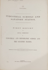
Booklet - Report, John Ferres, Government Printer, Royal Commission on Industrial and Reformatory Schools and the Sanatory Station, 1872 and 1874
The Industrial Schools and Quarantine Station Royal Commission took place in 1872, with the final report published in 1874..1) First report of the Royal Commission on Industrial and Reformatory Schools and the Sanatory Station. 65 pages. .2) Second and final report of the Royal Commission on Industrial and Reformatory Schools and the Sanatory Station. 16 pages. This report included defects in the system and recomendations.On front cover "From Tom Evans MLA"quarantine, industrial schools, reformatory schools, royal commission, gavin duffy, st kilda road industrial school, industrial schools commission, red hill philanthropic school, flat islands port phillip bay, pauper children, johanna margaret hill, american industrial schools, cuthbert fox, james walker, pilot schooner rip, captain h.h. o'neil, william mccrae, t.m. girdlestone, william austin zeal, j.a. panton, industrial schools and quarantine station royal commission, quarantine station point nepean, sanatory station, queenscliff, point nepean, philanthropic school red hill, rip, george ferguson bowen, orphan asylums -
Federation University Historical Collection
Plan, Mount Helen Campus Plan, 1997, 1997
The Union Building was later named the Albert Coates Centre, and the Aboriginal Education Centre moved from T Building to the first floor of the Albert Coates Centre in 2011. Mount Helen Campus Plan showing the location of buildings and roads. mount helen campus, campus plan, union builidng, aboriignal education unit, albert coated building -
Federation University Historical Collection
Plan, Federation University Mount Helen Campus, 2022, 2022
A map showing the layout of buildings, roads and carparks on the Federation University Mount Helen Campus.federation university mount helen campus, campus plan, founders theatre, albert coates centre, student accomodation, student residences, albert coates complex, apretc tower, caro convention centre, helath and sports precinct, fedliving, e.j. .barker library, aboriginal education centre, bai err, murnong, geoffrey blainey research centre, swimming pool, international student support, fed children's centre, muslim prayer room, acquatic centre, herbert werner frederick de nully, peter lalor hall, bella guerin hall -
 Federation University Historical Collection
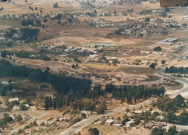
Photograph, Site of Sovereign Hill and Ballarat Lodge
The Old Ballarat Travel Inn was located at 613 Main Road. It later Became Ballarat Lodge and Mecure Ballarat.Photograph showing the site of Sovereign Hill in fron to the pine trees, and Elsmore street running along the right. Ballarat Lodge, the brainchild of John Gilbert, can be seen in front of the dam in the centre. The start of Magpie Street can be seen on the left hand side of the photograph.ballarat lodge, john gilbert, sovereign hill, elsmore street, main road, ballarat east, old ballarat travel inn -
Federation University Historical Collection
Document - Document - Letter, Ballarat Junior Technical School: Circular to schools from District Inspector, 1952
Circular from the District Inspector, Earl G Pearson, to all schools, June 1952. Divided into six headings. 1. Education Week information and suggestions. Will be held August 10th to 16th. Sunday 10th is Education Sunday. 2. State Schools' Horticulture Society return form nursery shows very little support. All school should support this and pay annual fee of 7/6d. Location is Teachers' Nursery, Poath Road, Oakleigh. ( Became State Schools' Nursery and now Victorian Schools' Nursery No 4214). 3. Inspection. Teachers to read sections of Regulations and Instruction which will be helpful in assessing efficiency of their work and give direction on organisation. Entry age for new students. Restriction maybe necessary to conserve teaching staff. 3. School residences. 4. Desk surplus. 5. Young Farmers' Clubs. New organizer for schools. Been taken over by Education Department.Cream page, typed ballarat junior technical school, head master, l garner, earl pearson, district inspector, circular, june 1952, education week, state schools' horticultural society, inspection, regulations and instructions, work efficiency, organisation, school enrolments, school residences, desk, young farmers' clubs -
Federation University Historical Collection
Book - Index Book, Ballarat School of Mines and Industries, Ballarat, School of Mines and Industries Ballarat Index Book 1957, 1957
School of Mines is a predecessor of Federation UniversityThis book is an index correspondence of the School of Mines in the 1992 giving us an understanding of the operations of the School of Mines in that era and of the people involved with the institution at that time. It shows projects that were being undertaken at the institution at the time and gives us an historical perspective on project costs and the type of work being doneBrown book with blue spine with Index Book 1957 written on the front and a label with faint ruled.index book, school of mines ballarat, angus and robertson ltd, australian wool bureau, australian institute of political science, ballarat metal pty ltd, e.j barker, baxter and stubbs, g biddington, country roads board, cowley's eureka ironworks, footscray technical school, government printer, henry haymes pty ltd, h.g proctor -
Federation University Historical Collection
Book - Index Book, Ballarat School of Mines and Industries, Ballarat, School of Mines and Industries Ballarat Index Book 1958, 1958
School of Mines is a predecessor of Federation UniversityThis book is an index correspondence of the School of Mines in 1958 giving us an understanding of the operations of the School of Mines in that era and of the people involved with the institution at that time. It shows projects that were being undertaken at the institution at the time and gives us an historical perspective on project costs and the type of work being doneRed book with Index Book 1958 written on a label on the front coverindex book, school of mines ballarat, angus and robertson ltd, australian wool bureau, australian institute of political science, ballarat metal pty ltd, e.j barker, baxter and stubbs, g biddington, country roads board, cowley's eureka ironworks, footscray technical school, government printer, henry haymes pty ltd, h.g proctor -
Federation University Historical Collection
Book - Index Book, Ballarat School of Mines and Industries, Ballarat, School of Mines and Industries Ballarat Index Book 1959, 1959
School of Mines is a predecessor of Federation UniversityThis book is an index correspondence of the School of Mines in 1959 giving us an understanding of the operations of the School of Mines in that era and of the people involved with the institution at that time. It shows projects that were being undertaken at the institution at the time and gives us an historical perspective on project costs and the type of work being doneRed book with Index Book 1959 written on a label taped to the front coverindex book, school of mines ballarat, angus and robertson ltd, australian wool bureau, australian institute of political science, ballarat metal pty ltd, e.j barker, baxter and stubbs, g biddington, country roads board, cowley's eureka ironworks, footscray technical school, government printer, henry haymes pty ltd, h.g proctor