Showing 1016 items
matching boundary
-
 Ballarat Tramway Museum
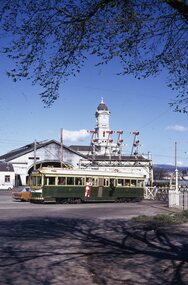
Slide - 35mm slide/s - set of 6, Campbell Duncan, 19/09/1971 12:00:00 AM
Yields information about the operations of the Ballarat Tramway system on the last day of SEC tramway operations in Ballarat.Set of 6 Kodak - Kodachrome slides - cardboard mounts - all taken on 19/9/1971, last day of operations prior to closure of the SEC operated tramway. .1 - Tram 40, waits at the level crossing gates - the gates are being opened. In the background is the station building and the signal gantry. Tram has the destination of Sebastopol. .2 - No. 42, with destination of Lydiard St north, northbound in Lydiard St, with railway station buildings and VRI in the background. .3 - No. 35 on inbound, Lydiard St North. .4 - No. 35, on inbound service, leaving Skipton St loop with another bogie in the background. .5 - No. 39 on inbound service, Albert St Sebastopol with the Sebastopol boundary sign and Binks Ford in the background. Tram has an everything under control in my all electric kitchen roof advert. .6 - No. 42, with destination of Sebastopol, Albert St Sebastopol.In ink on slide: .1 - Sun 19 Sept 71 - up Lydiard St Nth waits for gates to be opened after fast goods. .2 - Sun 19 Sept 1971, down Lydiard St Nth near VRI. .3 - Sun 19 Sept 1971, Up Lydiard St Nth .4 - Sun 19 Sept 1971, Up Sebastopol (supplementary service) has just crossed down in Skipton St near Drummond St. .5 - Sun 19 Sept 1971, Up Sebas at Ballarat / Sebastopol boundary. .6 - Sun 19 Sept 1971, c5.30pm down Sebas in Sebas shire.tramways, trams, lydiard st nth, railway station, level crossings, skipton st, albert st, sebastopol, closure, last day, tram 40, tram 42, tram 35, tram 39 -
 City of Kingston
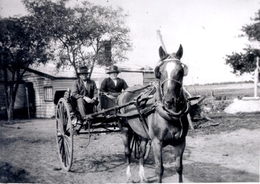
Photograph - Black and white, c. 1920
Vic Peterson and his mother, Ida Peterson, are seated in a carriage with a horse harnessed to the front. Their property was between East Boundary and Brady Road, East Bentleigh.Black and white image of a horse and cart, with a man and woman sitting in the cart.Black ink printed on white round sticker on reverse: 335 Handwritten in red ink on reverse: 70%horse drawn wagon, east bentleigh -
 Bendigo Historical Society Inc.
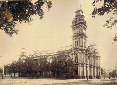
Photograph - BENDIGO TOWN HALL
Sepia image mounted on board. Image shows Bendigo Town Hall taken from north side, looking south down Hargreaves Street. Trees along north boundary of building. Gas lamps alongside kerb in Hargreaves Street. Market building visible alongside Town Hall.bendigo, buildings, bendigo town hall, bendigo, town hall, municipal buildings, hargreaves street -
 Clunes Museum
Map, 1962
.1 &.2 MAP OF BALLARAT SHIRE GROUP RURAL FIRE BRIGADES FIRE CONTROL MAP. COMPILED BY C. H. FENTON. (2 COPIES) DETAILING SEALED ROADS, STATE FORESTS, PINE PLANTATIONS, FOREST AREAS, RAILWAYS, BOUNDARIES, TOWNSHIP AREAS CEMETERIES, CREEKS, SWAMPS AND HOUSES.local history, document, maps, fire brigade -
 Eltham District Historical Society Inc
Negative - Photograph, J.A. McDonald, Heidelberg-Kinglake Road, Sep. 1960
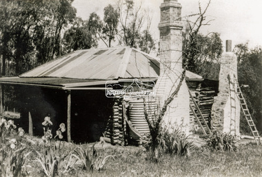
Looking north from south boundary of St Andrews Township (Cr. Brinkkotter in car) Noted on album page as September 1960 but photo dated October on reverseRecord of various Shire of Eltham infrastructure works undertaken during the period of 1952-1962 involving bridge and road reconstruction projects, sometimes with Eltham Shire Council Project Reference numbers quoted. It was during this period that a number of significant improvements were made to roads and new bridges constructed within the shire that remain in place as of present day (2022). In many situations, the photos provide a tangible visible record of infrastructure that existed throughout the early days of the Shire. The album was put together by or under the direction of the Shire Engineer, J.A. McDonald.infrastructure, shire of eltham, bridge construction, road construction, cr. a. brinkkotter, heidelberg-kinglake road, st andrews, 1960-09 -
 Eltham District Historical Society Inc
Document - Folder, Eltham Shire: Guide to historical sources held in the LaTrobe and Reference Library Collections, State Library of Victoria, 1980
Two copies. Folders 68 and 74 from Harry Gilham Collection. "The following work was undertaken at the request of the Shire Planner of the Shire of Eltham to aid in the establishment of a total inforamtion system for the Shire. It is primarily a guide to sources of historical information on the area within the present shire boundaries and also the additional areas which were within the shire's former boundaries". Sources are arranged in the following sections: bibliographies, books and pamphlets, serials, electoral rolls, directories, statistical material, maps, pictorial material and manuscripts.12 pages in a manilla folderWithdrawn copy from Yarra Plenty Regional Librarybibliography, library -
 Heidelberg Golf Club
Book, Melbourne Parks and Waterways, Lower Plenty River concept plan: Maroondah Pipe Track to Yarra River, 1994
Lower Plenty River concept plan: Maroondah Pipe Track to Yarra River. Includes suggestion of Plenty River Trail along the west boundary of the Heidelberg Golf Club.66 p., illus., colour map. Also, Draft copy of document.plenty river trail, lower plenty river, heidelberg golf club, mmbw, melbourne parks and waterways -
 Bendigo Historical Society Inc.
Document - MALONE COLLECTION: MACOBOY LETTERS, 1907
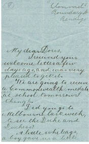
2 handwritten letters from Cecily Macoboy 'Clonmel' Boundary St Bendigo (now Valentine St) to her friend Doris. Also included is a piece of paper addressed to Doris from Kathleen. Part of this is written in French, and on the larger side what appears to be a song and the notes required to play this music.Cecily Macoboyperson, family, malone collection, malone collection, macoboy letters, cecily macoboy -
 Bacchus Marsh & District Historical Society
Map, Lerderderg District Proposed Irrigation and Water Supply Trust (A). Plan showing boundaries of Trust District
The 1886 Irrigation Act in Victoria introduced the first legislation in Australia designed to enable the creation of a detailed scheme for agricultural irrigation. Part of the legislation saw the use of government funds for local irrigation projects. These local projects were managed by local irrigation trusts. The Lerderderg Irrigation and Water Supply Trust] was formed in 1890. This map depicts the proposed area of the Trust.Printed paper map of the proposed Lerderderg District Irrigation and Water Supply. Plan showing boundaries of Trust District. The Lerderderg District lies within the Parishes of Korkuperrumul and Merrimu in the County of Bourke. At the top of the map above its title is the letter 'A; in capital lettering. Scale: 40 Chains = 1 inch.irrigation, water supply, lerderderg irrigation and water supply trust -
 Ringwood and District Historical Society
Letter - clipping, Letter to Town Clerk Ringwood 1939 from Ringwood East Primary re Footpath culvert
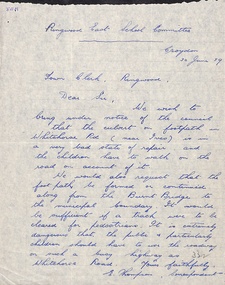
A letter dated 30 June 1939 to the Town Clerk Ringwood from E Thompson Ringwood East School Committee advising the Council that the culvert on footpath in Whitehorse Road is in a very bad state of repair. Also requesting that the footpatch be formed or continued along from the Burnt Bridge to the municipal boundary. -
 Greensborough Historical Society
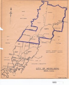
Map, City of Heidelberg, City of Heidelberg, 1962, 02/02/1962
Map of City of Heidelberg showing boundaries of its six wards; North Ward is highlighted, covering Watsonia, Greensborough, part Bundoora, St Helena, Plenty, Yarrambat and Diamond Creek.Blue print mapCity of Heidelberg Scale: 1" to 1 ml. G.M.H. 2.2.62city of heidelberg, heidelberg - maps -
 Wangaratta RSL Sub Branch
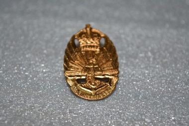
Gold Badge
WW2 War Service Badge issued to former soldiers who had served within the boundaries of Australia and who were, therefore, not eligible for the RAS badge. To be worn on civilian clothing.Gold badge with crown on top, rising sun in middle, an anchor at the bottom.On front: Service at bottom of crown. Australia is written at bottom, under anchor. On back: 1948, Issued by C'Wealth Govt, Amor Sydney. 49241australia, wwii, world war 2 -
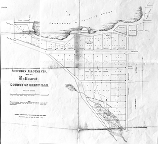 Friends of Ballarat Botanical Gardens History Group
Work on paper - Suburban Allotments (west of) Ballaarat, Wendouree or Yuille's Swamp, County of Grenville 30/4/1856, 30/4/1856. No date given for photocopy
This map of the 1856 survey shows the numbered suburban allotments and the boundaries surrounding this area including Wendouree or Yuilles's Swamp close to where the Ballarat Botanical Gardens and the Lake exist today. This map gives a clear idea of an early survey of this western area and directions to areas of Ballarat surrounding these allotments.2 pages of the same map, except p.2 shows the Township Reserve on the lefthand side of the page. On the back of p.2, righthand corner is the Public Records Stamp.P2, righthand corner is the citation in pencil.john garner, doctor john garner, ballarat botanical gardens, friends of ballarat botanical gardens, map of western suburban allotments 1856, county of grenville, public record office of victoria, john garner collection, gardens, ballarat -
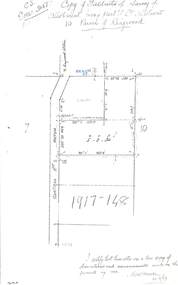 Ringwood and District Historical Society
Document - Copy of Lands Department Field Notes - Parish of Ringwood, Victoria, Field Notes 1917/148 - Part of O.P. R72 - Crown Allotment 10, surveyed June 1917
5614b Foolscap size photocopy of survey map with handwritten notations. References include Wantirna Road, to Ringwood Station, Reilly Street, J. Marshall, fence to be erected on boundary, I certify that these notes are a true copy of observations and measurements made on the ground by me (signed) H.W. Moore 22/6/17. -
Beechworth Honey Archive
Map- Albury
Map centred on Albury, showing Wodonga, Beechworth, Yackandandah and Chiltern. Topographic survey scale 1:100,000. Map is colour, printed on paper. Produced by Department of Minerals and EnergySheet 8225 (ed.1) series R. 652 Notes written on side regarding brigade boundaries, constructed access roads and fire trails, dams suitable for quick fill pump and areas 'fuel reduction burns Autumn 76'.map, albury, wodonga, beechworth, yackandandah, chiltern, paper, topographic, beechworth honey -
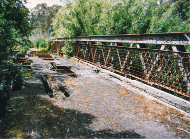 Eltham District Historical Society Inc
Photograph, Doug Orford, Lower Plenty Bridge, Old Eltham Road, Lower Plenty, 1998
Originally the boundary between the former Shire of Eltham and the City of Heidelberg, a toll gate existed on the Eltham side. The bridge has since been restored and is now part of the Plenty River Trail.Two colour photograph prints 10 x 15 cm (2 copies)bridges, lower plenty, main road, plenty river, old eltham road -
 Bayside Gallery - Bayside City Council Art & Heritage Collection
Map, Department of Crown Lands and Survey et al, Moorabbin, County of Bourke, Government Roads, 1920
The cadastral map of the Parish of Moorabbin in Victoria (L.6104) shows parish boundaries and land ownership 1920 when Sandringham was a Town. The government roads have been coloured in red pencil.moorabbin, county of bourke, map, plan, land subdivision, land titles, foreshores, hampton, beaumaris, highett, cheltenham, department of lands and survey, land owners, cartographic material, brighton, sandringham, town of sandringham, government roads -
 Ballan Shire Historical Society
Map - Map. Kerrit Bareet, Department of Lands and Survey, Kerrit Bareet. County of Grant, 08/1944
A map of the Kerrit Bareet area within the County of Grant showing properties and names of owners in 1944.Significant to people researching land usage and ownership. Also those researching families in the area at that time.A map of Kerrit Bareet in the County of Grant. Black printing on buff coloured paper. Details roads, rivers, railways, property boundaries and names of property owners and towns and villages. The map is easily readable although there is some physical damage and that and the borders have been reinforced with sellotape. Shows a Scale in Chains and Price 2/.gordon, bungal, kerrit bareet, lal lal, moorarbool river, warrenheip, bungaree, wallace, moorarbool west -
Port Melbourne Historical & Preservation Society
Newspaper - Newspaper, Brawl between Port Melbourne and Dandenong, Junction Oval, St Kilda, The Sun, 20 Sep 1976
"The Sun" newspaper 20 September 1976 with report of brawl at St Kilda's Junction Oval during the 1976 VFA Grand Final between Port Melbourne and Dandenong football clubs the previous day. It began when Port player Fred COOK was felled behind play and a boundary umpire was also knocked downsport - australian rules football, port melbourne football club, pmfc, fred cook, colin walker, tony haenen, greg dermott, allan thomas, david holt, george allen, greg bond, jim christou, norm brown, graham 'buster' harland -
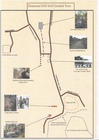 Bendigo Historical Society Inc.
Document - DIAMOND HILL SELF GUIDED TOUR
One page coloured map of historical sites in the Diamond Hill area. Including the Golconda Battery site, Tramway Embankment, site of former Town and Country Hotel, Sandhurst Municipal Boundary Marker Post, Waterwheel Cutting, Stafford Mine site. On the back a description of the various sites. Produced by the Bendigo Historical Societybendigo, tourism, diamond hill -
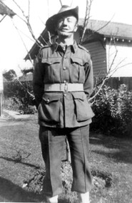 Surrey Hills Historical Society Collection
Photograph, Bill Willaton in WW2 army uniform, 1942
Date is approximate. His full name was William John Willaton - Service Number - VX68674 : Date of birth - 20 Mar 1909 : Place of birth - SURREY HILLS VIC : Place of enlistment - CAULFIELD VIC : Next of Kin - MURIEL WILLATON He was the son of Herbert Charles Leopold Willaton and Lily Jenkins and had a sister Lille Louise (Lil) who taught callisthenics and dance in Surrey Hills. Photo references also in this collection. Bill married Muriel Pearl Blake in 1935 and they lived at 18 Grovedale Road. He died Heidelberg in 1972. Bill was a driver (carter) for C E Gray & Son, bakers of Canterbury during the 1930's also recorded in this collection.Black and white photo of Bill Willaton in army uniform including a slouch hat. He is standing with his arms behind his back in front of a fairly young deciduous tree beyond which is a boundary fence and a timber building with a tiled roof. A child's pedal-car can be seen adjacent to the house of the garden. world war, 1939-1945, uniforms, william john willaton, bill willaton, -
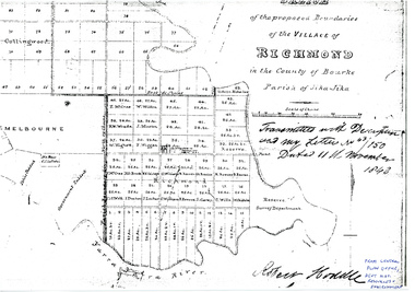 University of Melbourne, Burnley Campus Archives
Plan - Sketch, Sketch of the Proposed Boundaries of the Village of Richmond, 1843
Sketch of the proposed boundaries of the village of Richmond in the County of Bourke Parish of Jika-Jika. Handritten, "Transmitted with Descriptioon and my letter No 43/150 Dated 11th November 1843 Robert Hoddle." Shows Burnley Gardens site as, "Reserve. Survey Department." From Central Plan Office, Department of Natural Resources and Environmentrichmond, jika-jika, robert hoodle -
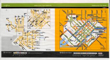 Melbourne Tram Museum
Poster, Yarra Trams, "Melbourne Tram Network", Nov. 2005
Full colour poster printed, A3 size, on laminated sheet - titled "Melbourne Tram Network. Shows a diagrammatic layout of the Melbourne tram system, shows zones (2 zones), CBD, tram terminuses including the City Saver boundary. Has the Yarra Trams and Metlink logos. Dated Effective November 2005trams, tramways, yarra trams, metlink, maps, metcard, tickets, city section -
Glen Eira Historical Society
Document - Goldstein, Vida
One item on electoral division of Goldstein. Profile details of electoral division, updated 22/02/2012 plus map showing boundaries of Electoral Division of Goldstein gazette 24/12/2012.electoral boundaries, ‘goldstein’, vida goldstein, suffragist, feminist movement, maps -
 Bendigo Historical Society Inc.
Photograph - T C WATTS & SON COLLECTION: BENDIGO HOUSE, 1927
Brydon Stewart Melrose (1895-1989) was a dentist. He married Florence Emily Reville in 1921. Their home in Myrtle Street was called Morayfield. In the mid to late 1930's they moved to Boundary Street.Black and white photograph mounted on rectangular grey board. House, weatherboard, cement sheet and timber under eaves. Double door entrance. Rough cast cement verandah with timber posts. Two palms in front. Timber top rail to closely slatted wooden fence, chimney pots visible. On back of photo:" Bryden Melrose, £850, Date stamp 9 December 1927. refer S & U, D.T. Coy first'Frank A. Jeffree Bendigoplace, building, residential, stamped on back in rectangle ''t.c. watts and son/auctioneer/estate agents/253 mitchell street/bendigo'' stamped on back in circle ''royal historical society of victoria, bendigo branch'' -
 Kew Historical Society Inc
Plan - Subdivision : Cotham and Glenferrie Roads, J R Mathers & McMillan
The Kew Historical Society's map collection includes a substantial number of real estate subdivision plans, mainly of Kew but also of surrounding suburbs in Melbourne. Most of the subdivision plans date from the 1920s and 1930s when the districts old homes and local farmland were being split up to accommodate residential growth in the postwar period. These early plans were assembled by a local firm, Jas R Mather & McMillan, which had an office in Cotham Road. Many of the plans, and sometimes photos, were annotated by the agents.Subdivision plans are historically important documents used as evidence for the growth of suburbs in Australia. They frequently provide information about when the land was sold as well as evidence relating to surveyors and real estate and financial agents. The numerous subdivision plans in the Kew Historical Society's collection represent working documents, ranging from the initial sketches made in planning a subdivision to printed plans on which auctioneers or agents listed the prices for which individual lots were sold. In a number of cases, the reverse of a subdivision plan in the collection includes a photograph of a house that was also for sale by the agent. These photographs provide significant heritage information relating house design and decoration, fencing and household gardens.The photograph may also be aesthetically significant depending on the importance of the photographic atelier.An undated and untitled hand-drawn and coloured subdivision plan detailing the boundaries of a number of irregular allotments bordering Cotham Road, Glenferrie Road and Stirling Avenue (now Stirling Street). The plan predates the actual subdivision that led to the creation of the eight commercial properties occupying 118-132 Cotham Road. The plan may represent an old subdivision that was further subdivided at a later date, or it may be a subdivision that never eventuated. On MMBW Detail Plan 1575 (1903), the area represented by the proposed subdivision was residential rather than commercial. The irregularity of lots is also apparent in the MMBW Plan. The largest of the unnumbered blocks on the hand-drawn subdivision plan may relate to the boundaries of the nineteenth century mansion identified as ‘Kelso’ on the MMBW Plan.subdivision plans - kew, cotham road - kew,, glenferrie road - kew , stirling avenue street - kew -
 Eltham District Historical Society Inc
Photograph - Black and White Print, Old settler's cottage, Floods Lane, North Warrandyte, c.1935
An early settler's cottage of 1920s vintage near Floods Rd taken in the 1930s. Was originally Floods Lane and became Floods Road off Kangaroo Ground-Warrandyte Rd near boundary of North WarrandyteInscribed in pencil on reverse "early 20's near Flood Rd taken 30's. 21/1.89" and in pen ".16/1.80"cottage, floods lane, floods road, houses, kangaroo ground-warrandyte road, north warrandyte, pioneers -
 Eltham District Historical Society Inc
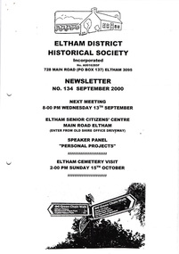
Newsletter, Newsletter, No. 134 September 2000
Contents: • Next meeting, Speaker Panel: Personal Projects • September Meeting • Eltham Cemetery Visit • Kangaroo Ground Boundaries • Chronology • ‘Not Just a Pretty Place’ • Family Histories of Eltham • Other News Items The Shire of Eltham Historical Society was formed in October 1967. The first newsletter of the Society was issued May 1978 and has been published continuously ever since on a bi-monthly basis. With the cessation of the Shire of Eltham in late 1994, the Society's name was revised to Eltham District Historical Society and this name first appeared with issue No. 103, July 1995. The collection of the Society's newsletters provides a valuable resource on the history of the Society's activities, office bearers and committee members, guest speakers and subjects of historical interest pertinent to the former Shire of Eltham and the Eltham District.A4 photocopied newsletter distributed to membersnewsletter, eltham district historical society, shire of eltham historical society -
 Ballarat Tramway Museum
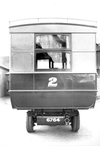
Photograph - Geelong Tramways MESCo bus No. 2
Rear of MESCo's bus No. 2, built for their East Geelong route between the East terminus at Boundary Road and the railway station or Moorabol St. wharf. Note the twin rear tyres. Looks new, 1912.Black and white print on paper.No. 1 inside a circle written on the reverse in pen. 14-2 and GRS710/14/1/2 written n the reverse in pencil.geelong tramways, mesco bus no. 2 -
 Phillip Island and District Historical Society Inc.
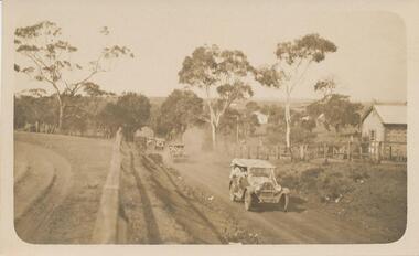
Photograph - Post Card, Cowes School Back to 1926 Chapel Street, March 1926
Donated by Stan McFee from the Keith McIlwraith CollectionSepia postcard of four cars , decorated with streamers, driving along Chapel Street going west on unmade road. Land on left was owned by Methodist Church, corner of Chapel and Bass Ave., where large tree denotes the boundary. Finley? Forrest's house on right. Coming to Back to Cowes School Celebration March 1926On back: "Back to Cowes March 1926"celebrations - back to cowes school phillip island, decorated cars, phillip island, stan mcfee, keith mcilwraith collection