Showing 607 items
matching early 1930s
-
 Brighton Historical Society
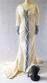
Dress, Wedding dress, 1938
This wedding dress and headpiece were worn by Emily Elizabeth (Betty) Cock (1907-2001) when she married Euston Murray Nutchey at St Andrew's Church, Brighton, on 28 April 1938. The bride's great-grandmother, Emily Cock (nee Smith), was married in the same church 69 years earlier; Emily's dress is also in the Brighton Historical Society collection. The dress was made by Melbourne dressmaker Beatrice Cook, with distinctive blue beaded panels worked by Betty's younger sister Margaret (1915-2006) to match the wedding's blue-and-pink colour scheme. The dress was accessorised with a pale blue tulle veil and a bouquet of blue hydrangeas, delphiniums and pale pink roses.Satin dress cut on the bias, originally ice-blue, now faded to cream. The dress features a long train and broad v-neck. The bodice and waist are softly ruched and gathered on either side of a finely beaded centre panel running from the neckline to the hem. The beadwork features a design of small cream-coloured leaves winding between large stylised blue flowers and leaves, all bordered with silver beads. Full-length sleeves are slightly puffed at the shoulder, narrowing to a close fit, with beaded cuffs matching the centre panel. The dress is accompanied by a matching blue, cream and silver beaded coronet or headpiece; this was originally worn with a pale blue tulle bridal veil.Label, woven mauve on beige silk, centre back: Beatrice Cookbetty cock, betty nutchey, emily elizabeth cock, emily elizabeth nutchey, euston murray nutchey, beatrice cook, wedding dress, st andrew's church brighton, 1930s, frances margaret cock, frances margaret ward -
 Duldig Studio museum + sculpture garden
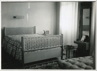
Furniture, Sigmund Jaray et al, Viennese bedroom suite manufactured by Sigmund Jaray Kunstmobelfabrik 1931, 1931
The Wiener Werkstätte (Viennese workshops) established by Josef Hoffman and Kolomon Moser in 1903 are today celebrated for their work in promoting the involvement of artists, designers and craftspeople in the manufacture of home furnishings; however Sigmund Járay’s firm was also an important, although today lesser-known, Viennese manufacturer of Kunstmöbel (art furniture). An Austro-Hungarian designer of Jewish descent, Sigmund Járay (1838-1908) established his Kunstmöbelfabrik (art furniture factory) in Vienna in the 1870s in partnership with his brother Sándro Járay (1845-1916), a sculptor. The firm with its team of cabinet makers, modellers, sculptors, upholsterers, painters and gilders, manufactured bespoke furnishings and decorated interiors for public and private clients, including the Imperial court. Such was the prominence of the work of this factory, that in 1899 one of the first purchases of the newly formed Austrian Museum of Applied art was a suite of furniture designed by Sigmund Járay for a married worker. In commissioning the furniture, Slawa was adopting the custom of Viennese couples to furnish their homes with bespoke furniture from the interior design firms that flourished in early 20th century in Vienna. Comparative material is held in the National Gallery of Victoria collection; a suite of furniture by Josef Hoffman commissioned by the Gallia family in 1912; and a suite of furniture by Adolf Loos commissioned by the Langer family in 1903. Ann Carew 2016The bedroom suite is aesthetically significant for the quality of its craftsmanship and design. It is a significant example of domestic interior design in Vienna during the 1930s. The bedroom suite is intact, and has been preserved in its entirety – double bed and side tables, wardrobe and linen press, stool and day bed. It has the potential to be displayed in situ in the place where it was last in use. It is of historical significance. Many Jewish families had all their possessions lost or destroyed during the war years. The story of the furniture’s journey from Austria to Australia is relevant to the study of the experience of émigré families during the Holocaust, and the importance of return of their property. It is rare, as it and the furniture in the living and dining room, are the only known examples in Australia of furniture manufactured by the firm of Sigmund Jàray. The provenance of the furniture is excellent, and is demonstrated by photographs taken in Vienna; correspondence with the donor’s sister, Rella; and the quotation from Sigmund Járay Kunstmöbelfabrik. It is in excellent condition. Ann Carew 2016Bedroom suite consisting of a double bed, two side tables, an upholstered stool and upholstered day bed, and a wardrobe and linen press. Made of Maple and Rosewood. Designed by the firm of Sigmund Jaray with Slawa Horowitz-Duldig. -
 National Wool Museum
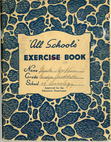
Wool Classing Exercise Book, 1941-1943
John Griffin’s wool classing exercise books from 1941-1943 when he was a student at the Gordon Institute in Geelong. John and his father John Henry Griffin owned a farm in Dunkeld and bred fine merino wool. One year they topped the wool sales figures for the area, in the late 1940s. There are four books in total. One book is on the topic of Veterinary Science and is from 1941. It contains information on topics such as birth and early lamb life, bone structure and other internal organisms of a sheep, such as the heart. Another book is on Wool Classing with topics such as wool scouring, dipping, shearing and micron counts. The third book is on general shearing shed knowledge. This includes a diagram for rolling a fleece, correct method for stamping a wool bale and branding abbreviations. The final book is on the History the Merino Sheep. It is a long form essay answer booklet. The Gordon institute and wool are synonymous with one another, the first class in wool sorting was offered at the Gordon in 1891. With much of the wool clip sent directly to England at this time, The Gordon's focus soon shifted to wool classing and marketing. By the 1930s, The Gordon's wool school was renowned as the state's wool industry training centre. Early specialist short courses were offered around Victoria to assist wool growers in preparing their clip for market, with modules on sheep breeding and pasture development included in the programs. Anne Griffin’s, John’s daughter, donated the exercise books to the National Wool Museum in 2021. Book 1 is predominately blue circular cover with cream background. Middle of book has pink highlighter mark. Reverse of book has an Arithmetical Table and a Multiplication Table in a blue ink on cream paper. It also has four black ink markings Book 2 is predominately blue circular cover with cream background. Book has red tape across the spine. Reverse of book has an Arithmetical Table and a Multiplication Table in a blue ink on cream paper. Book 3 is predominately blue plaid cover with cream background. Middle of book has pink highlighter handwriting which has been crossed with the same colour, leaving the text unreadable. Reverse of book has an Arithmetical Table and a Multiplication Table in a blue ink on cream paper. Book 4 is predominately blue diagonal striped book with cream background. Middle of book has small picture of Australia. Reverse of book has an Arithmetical Table and a Multiplication Table in a blue ink on cream paper. Book 1. Front cover: “All Schools” / EXERCISE BOOK / NAME Jack Griffin Grade Gordon Institute School of Technology(?) / Approved by the / Education Department Back cover. Reverse. ARTHMETICAL TABLES / (Numerous, see media) Book 2. Front cover: 2nd & 3rd / “All Schools” / EXERCISE BOOK / Name Jack Griffin / Grade 2 / School the Gordon / Approved by the / Education Department Back cover. Reverse. ARTHMETICAL TABLES / (Numerous, see media) Book 3. Front cover: Embassy / EXERCUSE BOOK / Name John Griffin / Grade 1 / School (?) / APPROVED BY THE EDUCATION DEPARTMENT / Back cover. Reverse. ARTHMETICAL TABLES / (Numerous, see media) Book 4. Front cover: EXERCISE / APPROVED BY EDUCATION DEPT. / BOOK / NAME Jack Griffin / GRADE 3 / SCHOOL Gordon Back cover. Reverse. ARTHMETICAL TABLES / (Numerous, see media) gordon institute geelong, wool classing, 1940s sheep farming -
 Brighton Historical Society
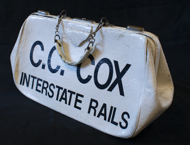
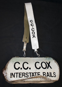
Bag, Bookmaker's bag, circa 1960s-1990s
Bags such as this one were used by bookmakers to collect and securely hold punters' bets at racing events. This bag belonged to Charlie Cox, a second-generation Australian bookmaker. His father, George Gordon Cox, ran bookmaking operations primarily during the 1920s and 1930s. After serving in the Air Force during the Second World War, Charlie entered the business during the 1940s, initially fielding at greyhound, trots and gallop meetings. In the early 1960s he moved to Melbourne, where he got his first big financial break when he was offered an interstate license to operate on the rails at all city tracks. He was a leading Melbourne bookmaker on the interstate rails racing circuit from the 1960s to the 1990s, from which period this bag originated.White painted leather bag with metal fastening mechanism. A short painted leather handle is joined to the bag by metal fastening clips.Painted on one side of the bag in black letters: "C.C. COX / INTERSTATE RAILS".bookmakers, horse racing, charlie cox, c. c. cox, interstate rails -
 Brighton Historical Society
Bag, Bookmaker's bag, circa 1960s-1990s
Bags such as this one were used by bookmakers to collect and securely hold punters' bets at racing events. This bag belonged to Charlie Cox, a second-generation Australian bookmaker. His father, George Gordon Cox, ran bookmaking operations primarily during the 1920s and 1930s. After serving in the Air Force during the Second World War, Charlie entered the business during the 1940s, initially fielding at greyhound, trots and gallop meetings. In the early 1960s he moved to Melbourne, where he got his first big financial break when he was offered an interstate license to operate on the rails at all city tracks. He was a leading Melbourne bookmaker on the interstate rails racing circuit from the 1960s to the 1990s, from which period this bag originated.White painted leather bag with metal fastening mechanism. A short painted leather handle is joined to the bag by metal fastening clips. A long painted leather strap is joined to the bag by metal fastening clips.Painted on one side of the bag in black letters: "C.C. COX / INTERSTATE RAILS". "C.C. COX" is also painted in black at either end of the shoulder strap.bookmakers, horse racing, charlie cox, c. c. cox, interstate rails -
 National Wool Museum
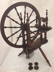
Spinning Wheel, 18th century or early 19th century
The spinning wheel was owned by Amy Penfold (donor Jan Dawson's mother) who presumably purchased the spinning wheel in the 1930s at an antiques auction. Amy lent the spinning wheel to her friends who spun (as Amy could not spin herself) In Yass, New South Wales during the early years of the Second World War. Amy's friends would spin lightly scoured semi greasy wool worked into yarn and knitted into particularly warm and water-resistant socks for sailors on minesweepers serving during the Second World War. Jan received the wheel in the early 1960s after her mother past away at which time the wheel was no longer operable. When Jan came to live in Melbourne, she sought the assistance of Spinners and Handweavers who assisted her in creating a new bobbin and restored the broken pieces of the wheel back into working order which we find it in today. With the loom are three bobbins. One bobbin is attached to the loom while of the two loose bobbins; one is a reproduction and one is an original. From these two the differences in construction can be observed. Large 12 spokes pinning wheel finished in dark tinted varnish on wood. Ornate upright posts.Additional two bobbins. One original and slightly damaged other is a reproduction and in excellent condition. -
 Puffing Billy Railway
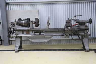
Lathe - Gap Bed, early 1900s
Possibly ex Victorian Railways Newport workshops Supplied by Bevan & Edwards Machinery Merchants, Melbourne Sebastian Lathes Described by its makers as the Utility School, Garage and Repair-shop Lathe, the machine immediately below, a Sebastian 15" (circa 1910 - 1926) was the Company's cheapest offering and, in its basic form, lacked a compound slide rest, the tailstock did not set over for taper turning and the bed lacked a gap. However, a friction-type countershaft unit was included in the price as well as a tool post, faceplate, drive plate, changewheels for screwcutting and a small tool kit. As with modern cars (especially BMW) everything worthwhile was on the options' list and by spending more it was possible to specify all those small but important extras. Although in its lowest-cost form this model was reduced to the fundamentals required for a useable, screwcutting centre (engine) lathe it was still reasonably specified and would certainly have fulfilled many requirements when installed in a school or training workshop. The true swing was 15.25", it was properly backgeared and screwcutting was through a conventional tumble-reverse mechanism that allowed both left and right-hand powered movement to the carriage by altering the position of just one lever. As standard it accepted 40" between centres, but any capacity could be ordered, in foot intervals, up to a maximum of 88" - when it is hoped that a central bed support might have been included …… The spindle, which ran in white-metal bearings, had a useful 15/8" hole and a No. 3 Morse taper centre. Some models appear to have had the leadscrew clasp-nut lever on the right-hand side of the apron, while on others it was positioned to the left.. Early Sebastian 13-inch lathe Typical of the Centre or "Engine" lathe made by many manufacturers from the late 1800s until the late 1930s, the basic flat-belt drive Sebastian, with separate countershaft, was eventually relegated to the economy end of the Company's range by the introduction of geared headstocks and self-contained motor-drive systems.Historic - Industrial Machinery - Gap Bed Lathe - Possibly ex Victorian Railways Newport workshops - Purchased and supplied from Bevan & Edwards Gap Bed Lathe - Grey with raw steel parts and a timber cupboard with gears and tools. Bevan & Edwards PTY,LTD Machinery Merchants Melbourne (possible government tag) 365bevan & edwards pty,ltd machinery merchants melbourne, puffing billy -
 Mt Dandenong & District Historical Society Inc.
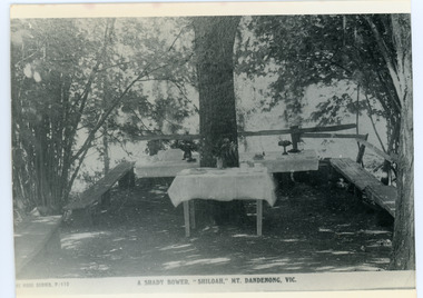
Photograph, Tea Tables at "Shiloah"
Originally the home of Isaac Jeeves, brother of Ellis Jeeves, ‘Shiloah’ was enlarged to take guests in the early 1900s. It was situated close to a beautiful fern gully and Isaac and his family capitalised on this by setting out walking tracks through the ferns. They charged 1/- to walk through and this included afternoon tea in a garden setting. ‘Shiloah’ was a popular tourist attraction but the making of the Olinda Creek Road destroyed the fern gullies and, by the 1930s, it was all finished. This photograph shows the tea tables at 'Shiloah' where Selina Jeeves and her daughter Elsie served afternoon tea to visitors.Black and white photograph taken from a Rose Series postcard showing tables set up in an exterior courtyard with bench seating.On front - Rose Series P. 170 A SHADY BOWER "SHILOAH" MT DANDENONG. VIC.shiloah, isaac jeeves the younger, guest house, afternoon tea, ferns, selina jeeves, elsie jeeves -
 Mt Dandenong & District Historical Society Inc.
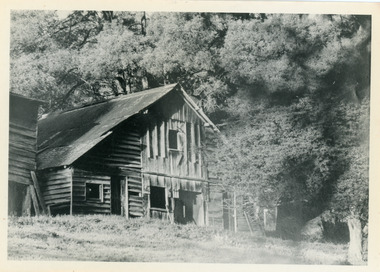
Photograph, Isaac Jeeves' Barn
Large barn built c1886 by Isaac Jeeves the younger on his property where the homestead 'Shiloah' stood. The barn was reputedly made from timbers split from only one messmate tree. Originally the home of Isaac Jeeves, brother of Ellis Jeeves, ‘Shiloah’ was enlarged to take guests in the early 1900s. It was situated close to a beautiful fern gully and Isaac and his family capitalised on this by setting out walking tracks through the ferns. They charged 1/- to walk through and this included afternoon tea in a garden setting. ‘Shiloah’ was a popular tourist attraction but the making of the Olinda Creek Road destroyed the fern gullies and, by the 1930s, it was all finished. John Lundy-Clarke grew up in the Kalorama/Mt Dandenong area and later in life (1972-74) began to write a comprehensive history of the area working from an original settlement map in an effort to cover all areas.Black and white photograph showing a large wooden structure surrounded by trees. Handwritten inscription on reverse by John Lundy-Clarke.Home of Isaac Jeeves the younger. Built about 1886 of timbers split from one messmate tree. Photo 1973isaac jeeves the younger, barn, kalorama, shiloah, messmate -
 Surrey Hills Historical Society Collection
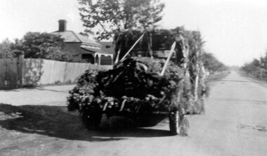
Photograph, Mr Wally Ives' car decorated for Empire Day, 1935
Wally Ives was a fruiterer who had a shop in Union Road. He was an active participant in the Empire Day parades of the 1930s. The donor Jean Boucher was the daughter of Wally Ives. She was an early active member of the History Nook at the Surrey Hills Neighbourhood Centre and member of the Surrey Hills Historical Society. The Oakland Motor Car Company was based in Pontiac, Michigan and was a division of General Motors. Although it was purchased by General Motors in 1909, the company continued to produce modestly priced automobiles until 1931 when the brand was dropped in favour of the division's Pontiac make. B&W photo of a decorated vehicle (Oakland car) parked in a street without kerbs or guttering. There is a Victorian-style house in the background.38. in black pen in top LH corner.(mr) wally ives, transport, croydon road, empire day, festivals and celebrations, oakland car, cars -
 Surrey Hills Historical Society Collection
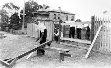
Photograph, St George's Church of England, Mont Albert working bee, early 1923 (2), 1923
The foundation stone for St George's Church of England, Mont Albert was laid in 1886 on land donated by Edward Dyer and the first service was preached in January 1887. From 1904 until 1907 it was known as Holy Trinity, Surrey Hills. The original church was weatherboard and replaced by a brick one in the Gothic Revival style which was designed by local architect George J V Blackburne, who also designed the Wesleyan School at Surrey Hills. The building was partly funded by donations, profits from a bazaar and concert, and other people donated furnishings. The church had boundaries along Mont Albert Road and St Georges Road. In 1998 the Church was sold and converted into a complex of units. Its current address is 19 St Georges Avenue, Mont Albert. The purpose of this working bee in 1923 was to close up the double gateway, which in earlier times had been used for entry of by horse-drawn vehicles to the church grounds. 'Lugano' was built in 1893 for William Wilson, a prominent stonemason and importer of marble fireplaces. In 1903 it became the home of William Holmes who was Chief Electrical Engineer for the Victorian Railways. He designed the electrification of the Melbourne suburban network. 'Lugano' stayed in the Holmes family until the 1930s. Norman Carter took many photos of Surrey Hills and Mont Albert from the 1920s in particular of events and activities associated with the Church of England.Black and white photo of 6 men behind and in front of a picket fence, a section of which has posts and railings only. In front of the fence is a wide grassy verge on which a bench is set up for cutting lengths of wood. A large Victorian house ('Lugano') can be seen in the background and a lamp post with a street sign. Beyond the house are mature eucalyptus trees.churches, holy trinity church, anglican church, st george's anglican church, working bees, lugano, william holmes, william wilson, norman brodley carter -
 Kew Historical Society Inc
Photograph - Brick and Stucco Bungalow, J E Barnes, c.1920
The Kew Historical Society's map collection includes a substantial number of real estate subdivision plans, mainly of Kew but also of surrounding suburbs in Melbourne. Most of the subdivision plans date from the 1920s and 1930s when the districts old homes and local farmland were being split up to accommodate residential growth in the postwar period. These early plans were assembled by a local firm, Jas R Mather & McMillan, which had an office in Cotham Road. Many of the plans, and sometimes photos, were annotated by the agents.Subdivision plans are historically important documents used as evidence for the growth of suburbs in Australia. They frequently provide information about when the land was sold as well as evidence relating to surveyors and real estate and financial agents. The numerous subdivision plans in the Kew Historical Society's collection represent working documents, ranging from the initial sketches made in planning a subdivision to printed plans on which auctioneers or agents listed the prices for which individual lots were sold. In a number of cases, the reverse of a subdivision plan in the collection includes a photograph of a house that was also for sale by the agent. These photographs provide significant heritage information relating house design and decoration, fencing and household gardens.The photograph may also be aesthetically significant depending o the importance of the photographic atelier.Real estate photograph for a local agent by the Kew photographer, Josiah Earl Barnes. The photo is of a weatherboard or brick rendered bungalow with a twisted wire fence. Given Barnes' status a a Kew photographer, the house is probably locate din Kew or East Kew. Unfortunately the handwritten information on the mount bordering the photo is damaged and cannot be read. The bungalow has a gabled, tiled roof with terra cotta finials at the front of both gables. The house has a central doorway, framed by a pseudo portico supported by four wooden columns. On each side of the doorway, at the front, there are paired sash windows, which, like the half-timbered gable, are picked out in a darker colour.Handwritten, mostly illegible description by selling agent on mount surround: " .... in Diningroom, Drawing Rooms, ... Photographers details printed on mount: "J. E. Barnes / Photo / Phone 1966 Haw KEW"houses - kew, bungalows - kew, real estate photographs, j.e. barnes -- photographer -
 Kew Historical Society Inc
Photograph - Victorian Double-fronted Brock Villa, Cotham Road, c. 1919
The Kew Historical Society's map collection includes a substantial number of real estate subdivision plans, mainly of Kew but also of surrounding suburbs in Melbourne. Most of the subdivision plans date from the 1920s and 1930s when the districts old homes and local farmland were being split up to accommodate residential growth in the postwar period. These early plans were assembled by a local firm, Jas R Mather & McMillan, which had an office in Cotham Road. Many of the plans, and sometimes photos, were annotated by the agents.Subdivision plans are historically important documents used as evidence for the growth of suburbs in Australia. They frequently provide information about when the land was sold as well as evidence relating to surveyors and real estate and financial agents. The numerous subdivision plans in the Kew Historical Society's collection represent working documents, ranging from the initial sketches made in planning a subdivision to printed plans on which auctioneers or agents listed the prices for which individual lots were sold. In a number of cases, the reverse of a subdivision plan in the collection includes a photograph of a house that was also for sale by the agent. These photographs provide significant heritage information relating house design and decoration, fencing and household gardens.The photograph may also be aesthetically significant depending o the importance of the photographic atelier.Real estate photographs of a classic double-fronted late Victorian brick villa. It central location in Cotham Road, Kew enabled the selling agent to note its proximity to the tram. With seven rooms, all ‘modern conveniences’, and land of 66×167, the house was to be sold for £1100. The villa has a number of interesting features including a pattern within the slate roof as well as the use of polychrome brickwork under the eaves and on the façade. The intricacy of the cast iron lace is emphasised by the line of projecting wooden blocks above it. The picket gate is painted a different colour to the pickets of the fence. The house has a name (illegible) that is attached to the inset cast iron lace of the central projecting gable in the veranda. Stamped on mount: "Kew. Central. Close tram. / Comfortable Brick Villa. / Containing 7 rooms / Modern conveniences: / Land 66 x 167. Sold 1100 pounds:"houses - kew, victorian villas, real estate photographs, cotham road - kew -
 Kew Historical Society Inc
Photograph - Double-fronted Edwardian Villa, c.1918
The Kew Historical Society's map collection includes a substantial number of real estate subdivision plans, mainly of Kew but also of surrounding suburbs in Melbourne. Most of the subdivision plans date from the 1920s and 1930s when the districts old homes and local farmland were being split up to accommodate residential growth in the postwar period. These early plans were assembled by a local firm, Jas R Mather & McMillan, which had an office in Cotham Road. Many of the plans, and sometimes photos, were annotated by the agents.Subdivision plans are historically important documents used as evidence for the growth of suburbs in Australia. They frequently provide information about when the land was sold as well as evidence relating to surveyors and real estate and financial agents. The numerous subdivision plans in the Kew Historical Society's collection represent working documents, ranging from the initial sketches made in planning a subdivision to printed plans on which auctioneers or agents listed the prices for which individual lots were sold. In a number of cases, the reverse of a subdivision plan in the collection includes a photograph of a house that was also for sale by the agent. These photographs provide significant heritage information relating house design and decoration, fencing and household gardens.The photograph may also be aesthetically significant depending on the importance of the photographic atelier.On the reverse of a subdivision plan of the Palmyra Estate (Kew) is a photograph of a double-fronted Edwardian villa. The weatherboard and stucco house with high brick chimneys provides a clear indication of the style of curtains and gardens in houses of the period. Holland blinds with lace inserts are used in the left front window. They are combined with long lace curtains. The garden, with its curved pathway is bordered with garden beds that include marguerite daisies and roses. Reflecting a new interest in the Australian landscape, tree ferns and ground ferns are planted closer to the house.houses - kew, architecture - edwardian, real estate photographs -
 Kew Historical Society Inc
Plan - Subdivision : Cotham and Glenferrie Roads, J R Mathers & McMillan
The Kew Historical Society's map collection includes a substantial number of real estate subdivision plans, mainly of Kew but also of surrounding suburbs in Melbourne. Most of the subdivision plans date from the 1920s and 1930s when the districts old homes and local farmland were being split up to accommodate residential growth in the postwar period. These early plans were assembled by a local firm, Jas R Mather & McMillan, which had an office in Cotham Road. Many of the plans, and sometimes photos, were annotated by the agents.Subdivision plans are historically important documents used as evidence for the growth of suburbs in Australia. They frequently provide information about when the land was sold as well as evidence relating to surveyors and real estate and financial agents. The numerous subdivision plans in the Kew Historical Society's collection represent working documents, ranging from the initial sketches made in planning a subdivision to printed plans on which auctioneers or agents listed the prices for which individual lots were sold. In a number of cases, the reverse of a subdivision plan in the collection includes a photograph of a house that was also for sale by the agent. These photographs provide significant heritage information relating house design and decoration, fencing and household gardens.The photograph may also be aesthetically significant depending on the importance of the photographic atelier.An undated and untitled hand-drawn and coloured subdivision plan detailing the boundaries of a number of irregular allotments bordering Cotham Road, Glenferrie Road and Stirling Avenue (now Stirling Street). The plan predates the actual subdivision that led to the creation of the eight commercial properties occupying 118-132 Cotham Road. The plan may represent an old subdivision that was further subdivided at a later date, or it may be a subdivision that never eventuated. On MMBW Detail Plan 1575 (1903), the area represented by the proposed subdivision was residential rather than commercial. The irregularity of lots is also apparent in the MMBW Plan. The largest of the unnumbered blocks on the hand-drawn subdivision plan may relate to the boundaries of the nineteenth century mansion identified as ‘Kelso’ on the MMBW Plan.subdivision plans - kew, cotham road - kew,, glenferrie road - kew , stirling avenue street - kew -
 Kew Historical Society Inc
Photograph - Cottage, probably East Kew, A. Aberline, 1920s
The Kew Historical Society's map collection includes a substantial number of real estate subdivision plans, mainly of Kew but also of surrounding suburbs in Melbourne. Most of the subdivision plans date from the 1920s and 1930s when the districts old homes and local farmland were being split up to accommodate residential growth in the postwar period. These early plans were assembled by a local firm, Jas R Mather & McMillan, which had an office in Cotham Road. Many of the plans, and sometimes photos, were annotated by the agents.Subdivision plans are historically important documents used as evidence for the growth of suburbs in Australia. They frequently provide information about when the land was sold as well as evidence relating to surveyors and real estate and financial agents. The numerous subdivision plans in the Kew Historical Society's collection represent working documents, ranging from the initial sketches made in planning a subdivision to printed plans on which auctioneers or agents listed the prices for which individual lots were sold. In a number of cases, the reverse of a subdivision plan in the collection includes a photograph of a house that was also for sale by the agent. These photographs provide significant heritage information relating house design and decoration, fencing and household gardens.The photograph may also be aesthetically significant depending on the importance of the photographic atelier.An elevated, modest weatherboard house, photographed towards the end of the construction phase. The lower section of the weatherboards are exposed and stained. The upper section is rendered with rough-cast. The tiled roof has a single gable that extends over the centrally placed front porch. On the porch, the door and single sidelight are filled with coloured leadlight whereas the casement windows in the front rooms contain plain glass. The leadlight and the wrought iron of the verandah are the only decorative elements of the utilitarian design. The location of the house, which was advertised for sale, has not to date been identified. The real estate photograph is mounted on the reverse of a subdivision plan for the Harvest Home Estate, Kew East.Photographer's stamp, lower right on mount: "A. Aberline, Glenferrie"houses - kew, bungalows - kew, real estate photographs -
 Kew Historical Society Inc
Photograph - Bungalow, probably East Kew, 1920s
The Kew Historical Society's map collection includes a substantial number of real estate subdivision plans, mainly of Kew but also of surrounding suburbs in Melbourne. Most of the subdivision plans date from the 1920s and 1930s when the districts old homes and local farmland were being split up to accommodate residential growth in the postwar period. These early plans were assembled by a local firm, Jas R Mather & McMillan, which had an office in Cotham Road. Many of the plans, and sometimes photos, were annotated by the agents.Subdivision plans are historically important documents used as evidence for the growth of suburbs in Australia. They frequently provide information about when the land was sold as well as evidence relating to surveyors and real estate and financial agents. The numerous subdivision plans in the Kew Historical Society's collection represent working documents, ranging from the initial sketches made in planning a subdivision to printed plans on which auctioneers or agents listed the prices for which individual lots were sold. In a number of cases, the reverse of a subdivision plan in the collection includes a photograph of a house that was also for sale by the agent. These photographs provide significant heritage information relating house design and decoration, fencing and household gardens.The photograph may also be aesthetically significant depending on the importance of the photographic atelier.An unusual bungalow that does not conform to a particular architectural style but which contains eclectic elements of the style of varying periods. The most striking element of the design is the cantilevered veranda that is supported by heavy chains that are attached to the central gable. This deep gable extends across most of the façade, forming an extensive veranda. Parts of this are infilled with screens. Seven wooden posts, whose lower halves are encased in rendered brick pillars, support this gabled veranda. The roof would appear to be covered with corrugated iron. The location of the house, which was advertised for sale, has to date not been identified. The real estate photo is on the reverse of a plan for the Myrtle Hill Subdivision, Kew.bungalows - kew, architecture - 1920s, real estate photographs -
 Kew Historical Society Inc
Plan - Subdivision Plan, J R Mathers & McMillan, Myrtle Hill Estate, East Kew, circa 1949, c.1949
The Kew Historical Society's map collection includes a substantial number of real estate subdivision plans, mainly of Kew but also of surrounding suburbs in Melbourne. Most of the subdivision plans date from the 1920s and 1930s when the districts old homes and local farmland were being split up to accommodate residential growth in the postwar period. These early plans were assembled by a local firm, Jas R Mather & McMillan, which had an office in Cotham Road. Many of the plans, and sometimes photos, were annotated by the agents.Subdivision plans are historically important documents used as evidence for the growth of suburbs in Australia. They frequently provide information about when the land was sold as well as evidence relating to surveyors and real estate and financial agents. The numerous subdivision plans in the Kew Historical Society's collection represent working documents, ranging from the initial sketches made in planning a subdivision to printed plans on which auctioneers or agents listed the prices for which individual lots were sold. In a number of cases, the reverse of a subdivision plan in the collection includes a photograph of a house that was also for sale by the agent. These photographs provide significant heritage information relating house design and decoration, fencing and household gardens.The photograph may also be aesthetically significant depending on the importance of the photographic atelier.Myrtle Hill, at 14 Vista Avenue, Kew, is of local historical and architectural significance as a good example of a large and imposing single-storey Italianate house of the early 1870s surviving in Kew. Originally sited on a large allotment overlooking Normanby Road, the setting of the house has been dramatically altered through extensive subdivision and development. The subdivision plan of the ‘Myrtle Hill Estate’ indicates that in one such subdivision, 11 allotments were created fronting Bowyer Avenue, Myrtle Avenue, and Normanby Road. The outline and building profile of Myrtle Hill is shown on the west side of Bowyer Avenue.The full (typed) title of this subdivision plan is :"Plan of SUBDIVISION of part of CROWN PORTION 83. / at KEW / PARISH OF BOROONDARA. / COUNTY OF BOURKE". / "MYRTLE HILL ESTATE / EAST KEW" In addition to the Title and subtitle, the plan also lists the advantages of the subdivision. -
 Kew Historical Society Inc
Plan - Subdivision Plan, J R Mathers & McMillan, Normanby Estate, c.1913
The Kew Historical Society's map collection includes a substantial number of real estate subdivision plans, mainly of Kew but also of surrounding suburbs in Melbourne. Most of the subdivision plans date from the 1920s and 1930s when the districts old homes and local farmland were being split up to accommodate residential growth in the postwar period. These early plans were assembled by a local firm, Jas R Mather & McMillan, which had an office in Cotham Road. Many of the plans, and sometimes photos, were annotated by the agents.Subdivision plans are historically important documents used as evidence for the growth of suburbs in Australia. They frequently provide information about when the land was sold as well as evidence relating to surveyors and real estate and financial agents. The numerous subdivision plans in the Kew Historical Society's collection represent working documents, ranging from the initial sketches made in planning a subdivision to printed plans on which auctioneers or agents listed the prices for which individual lots were sold. In a number of cases, the reverse of a subdivision plan in the collection includes a photograph of a house that was also for sale by the agent. These photographs provide significant heritage information relating house design and decoration, fencing and household gardens.The photograph may also be aesthetically significant depending on the importance of the photographic atelier.The Normanby Estate, which was adjacent to Normanby Road, Kew East, included thirty-one lots for sale. Streets on the subdivision plan include Adeney Avenue, Park Hill Road, Normanby Road, Weir Street and Wharton Street. Cotham Road and its tramway are shown nearby. The plan is interesting as it shows Wharton Street, named after the architect and town planner George Wharton, who was the first chairman of the Municipality of Kew. The street was to later be renamed Cecil Street. Also shown are proposed ‘Municipal Gardens’ where Parkhill Drive is now located."D" in top left corner. Stamped auctioneers contact details: "Jas. R. Mathers & Son & McMillan / Auctioneer & Land Salesmen, / 271 Collins Street / Melbourne" and Jas. R. Mathers / Estate & Financial Agent / Cotham Road / Kew".weir street - kew, wharton street - kew, normanby road - kew, cotham road - kew, municipal gardens - kew, park hill parkhill road - kew, braemar - kew, subdivision plans - kew -
 Kew Historical Society Inc
Plan, J R Mathers & McMillan, Sackville, Thomas & Lytton Streets, Kew, Twentieth Century
The Kew Historical Society's map collection includes a substantial number of real estate subdivision plans, mainly of Kew but also of surrounding suburbs in Melbourne. Most of the subdivision plans date from the 1920s and 1930s when the districts old homes and local farmland were being split up to accommodate residential growth in the postwar period. These early plans were assembled by a local firm, Jas R Mather & McMillan, which had an office in Cotham Road. Many of the plans, and sometimes photos, were annotated by the agents.Subdivision plans are historically important documents used as evidence for the growth of suburbs in Australia. They frequently provide information about when the land was sold as well as evidence relating to surveyors and real estate and financial agents. The numerous subdivision plans in the Kew Historical Society's collection represent working documents, ranging from the initial sketches made in planning a subdivision to printed plans on which auctioneers or agents listed the prices for which individual lots were sold. In a number of cases, the reverse of a subdivision plan in the collection includes a photograph of a house that was also for sale by the agent. These photographs provide significant heritage information relating house design and decoration, fencing and household gardens.The photograph may also be aesthetically significant depending on the importance of the photographic atelier.Lithographed subdivision plan for an un-named estate with 28 allotments facing Lytton, Sackville and Thomas Streets in Kew. The land would have originally formed part of the Dumaresq Estate. subdivision plans - kew, lytton street, sackville street, thomas street - kew -
 Kew Historical Society Inc
Plan - Subdivision Plan, Jas R Mathers Son & McMillan, Eastlawn Estate : East Kew Auction Sale, 1914
The Kew Historical Society's map collection includes a substantial number of real estate subdivision plans, mainly of Kew but also of surrounding suburbs in Melbourne. Most of the subdivision plans date from the 1920s and 1930s when the districts old homes and local farmland were being split up to accommodate residential growth in the postwar period. These early plans were assembled by a local firm, Jas R Mather & McMillan, which had an office in Cotham Road. Many of the plans, and sometimes photos, were annotated by the agents.Subdivision plans are historically important documents used as evidence for the growth of suburbs in Australia. They frequently provide information about when the land was sold as well as evidence relating to surveyors and real estate and financial agents. The numerous subdivision plans in the Kew Historical Society's collection represent working documents, ranging from the initial sketches made in planning a subdivision to printed plans on which auctioneers or agents listed the prices for which individual lots were sold. In a number of cases, the reverse of a subdivision plan in the collection includes a photograph of a house that was also for sale by the agent. These photographs provide significant heritage information relating house design and decoration, fencing and household gardens.The photograph may also be aesthetically significant depending on the importance of the photographic atelier.The ‘Eastlawn Estate’ was surveyed and ready for auction in March 1914, three months before the outbreak of World War I. Sixty-six allotments, created on the ‘order of Mr & Miss Preston’ surrounded the mansion of Woodlands in Harp Road. Woodlands formed part of the Estate, being advertised as lot 1. The allotments faced High, Station and Wright Streets, Harp and Normanby Roads, and Woodlands Avenue. Pru Sanderson in the Kew Conservation Study (Vol.2, 1988) wrote that the Eastlawn Estate ‘covered the western half of the failed Harp of Erin Estate’. Contemporary advertisements promoted the Eastlawn Estate as: ‘There will be no more convenient district nor pleasant Suburb than East Kew for the busy business man. When the Electric Tram is laid, he will be able to journey quickly and pleasantly direct from Collins Street to his home in the Eastlawn Estate in about 20 minutes’. The actual plans of subdivision were included in advertisements in The Argus and in the local newspapers."C" top left. Various annotations.subdivision plans - kew, station street, normanby road, high street, woodlands avenue, harp road, woodlands - kew -
 Kew Historical Society Inc
Plan - Subdivision Plan, Winton Estate, East Kew : Sale of 10 Building Blocks, 1920
The Kew Historical Society's map collection includes a substantial number of real estate subdivision plans, mainly of Kew but also of surrounding suburbs in Melbourne. Most of the subdivision plans date from the 1920s and 1930s when the districts old homes and local farmland were being split up to accommodate residential growth in the postwar period. These early plans were assembled by a local firm, Jas R Mather & McMillan, which had an office in Cotham Road. Many of the plans, and sometimes photos, were annotated by the agents.Subdivision plans are historically important documents used as evidence for the growth of suburbs in Australia. They frequently provide information about when the land was sold as well as evidence relating to surveyors and real estate and financial agents. The numerous subdivision plans in the Kew Historical Society's collection represent working documents, ranging from the initial sketches made in planning a subdivision to printed plans on which auctioneers or agents listed the prices for which individual lots were sold. In a number of cases, the reverse of a subdivision plan in the collection includes a photograph of a house that was also for sale by the agent. These photographs provide significant heritage information relating house design and decoration, fencing and household gardens.The photograph may also be aesthetically significant depending on the importance of the photographic atelier.Subdivision plan for the so-called Winton Estate in East Kew. The Estate comprised 10 lots facing Simpson Street and Campbell Street. The estate was auctioned by Jas. R. Mathers, Son and McMillan. campbell street, simpson street, hunter street, normanby road - kew, subdivision plans - east kew, subdivision plans - kew -
![7 Roomed Brick [villa]; Modern Conveniences](/media/collectors/550653872162f11fb04854aa/items/59ec3da221ea690fdc4ba793/item-media/59ec3ee521ea690fdc4d0c37/item-fit-380x285.jpg) Kew Historical Society Inc
Kew Historical Society IncPhotograph - 7 Roomed Brick [villa]; Modern Conveniences, 1920s
The Kew Historical Society's map collection includes a substantial number of real estate subdivision plans, mainly of Kew but also of surrounding suburbs in Melbourne. Most of the subdivision plans date from the 1920s and 1930s when the districts old homes and local farmland were being split up to accommodate residential growth in the postwar period. These early plans were assembled by a local firm, Jas R Mather & McMillan, which had an office in Cotham Road. Many of the plans, and sometimes photos, were annotated by the agents.Subdivision plans are historically important documents used as evidence for the growth of suburbs in Australia. They frequently provide information about when the land was sold as well as evidence relating to surveyors and real estate and financial agents. The numerous subdivision plans in the Kew Historical Society's collection represent working documents, ranging from the initial sketches made in planning a subdivision to printed plans on which auctioneers or agents listed the prices for which individual lots were sold. In a number of cases, the reverse of a subdivision plan in the collection includes a photograph of a house that was also for sale by the agent. These photographs provide significant heritage information relating house design and decoration, fencing and household gardens.The photograph may also be aesthetically significant depending on the importance of the photographic atelier.A professionally produced photograph for a local real estate agent, probably Jas. R. Mathers, Son & McMillan. The photograph is of a Federation-era bungalow, in Kew. The photo is on the reverse of a subdivision plan for the Normanby Heights Estate, Kew.The mount on which the photograph is placed includes: "Kew. 1 minute to tram. Good Position. / 7 roomed brick. Modern conveniences. / Land 60 x 135. 1100 pounds"real estate photographs, houses - kew, federation architecture -
 Kew Historical Society Inc
Plan - Subdivision Plan, Balwyn Theatre and Shop Sites, circa 1927-28, c.1927-28
The Kew Historical Society's map collection includes a substantial number of real estate subdivision plans, mainly of Kew but also of surrounding suburbs in Melbourne. Most of the subdivision plans date from the 1920s and 1930s when the districts old homes and local farmland were being split up to accommodate residential growth in the postwar period. These early plans were assembled by a local firm, Jas R Mather & McMillan, which had an office in Cotham Road. Many of the plans, and sometimes photos, were annotated by the agents. The ‘new’ Balwyn Picture Theatre was built and owned by Balwyn Theatres Pty Ltd in ca. 1928. By 1930, this first Balwyn Theatre was destroyed by fire after a break-in. Following the fire, a new cinema was constructed. This plan for a Cinema and eleven shops presumably dates from 1927/28 when the Company announced that this location in Whitehorse Road ‘was the most central and best suited [area] for their Theatre and shops’.Subdivision plans are historically important documents used as evidence for the growth of suburbs in Australia. They frequently provide information about when the land was sold as well as evidence relating to surveyors and real estate and financial agents. The numerous subdivision plans in the Kew Historical Society's collection represent working documents, ranging from the initial sketches made in planning a subdivision to printed plans on which auctioneers or agents listed the prices for which individual lots were sold. In a number of cases, the reverse of a subdivision plan in the collection includes a photograph of a house that was also for sale by the agent. These photographs provide significant heritage information relating house design and decoration, fencing and household gardens.The photograph may also be aesthetically significant depending on the importance of the photographic atelier.Subdivision plan showing the Balwyn Theatre and its adjoining shop sites in Whitehorse Road Balwyn. The 11 shop sites were noted for their depth (133 ft - 145 ft. [Map.0041]balwyn theatre -- balwyn (vic.), subdivisions -- balwyn (vic), subdivision plans -
 Kew Historical Society Inc
Plan - Subdivision Plan, Argyle Road, Heather Grove, Victor Avenue, Kew, c.1937
The Kew Historical Society's map collection includes a substantial number of real estate subdivision plans, mainly of Kew but also of surrounding suburbs in Melbourne. Most of the subdivision plans date from the 1920s and 1930s when the districts old homes and local farmland were being split up to accommodate residential growth in the postwar period. These early plans were assembled by a local firm, Jas R Mather & McMillan, which had an office in Cotham Road. Many of the plans, and sometimes photos, were annotated by the agents.Subdivision plans are historically important documents used as evidence for the growth of suburbs in Australia. They frequently provide information about when the land was sold as well as evidence relating to surveyors and real estate and financial agents. The numerous subdivision plans in the Kew Historical Society's collection represent working documents, ranging from the initial sketches made in planning a subdivision to printed plans on which auctioneers or agents listed the prices for which individual lots were sold. In a number of cases, the reverse of a subdivision plan in the collection includes a photograph of a house that was also for sale by the agent. These photographs provide significant heritage information relating house design and decoration, fencing and household gardens.The photograph may also be aesthetically significant depending on the importance of the photographic atelier.Undated blue subdivision plan in Kew of 14 lots facing Argyle Road, Heather Grove and Victor Road. The Plan identifies Tuxen & Miller as the surveyors. [Formerly catalogued as MAP.0059]subdivision plans - kew, argyle road - kew, heather grove - kew, victor avenue - kew -
 Kew Historical Society Inc
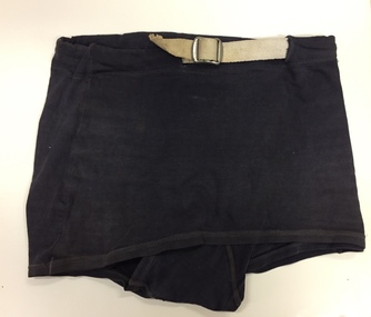
Clothing - Swimsuit, Alpha, 1940s
... in the 1930s. The fashion originated in France in the early 1930s ...The Fashion & Design collection of Kew Historical Society includes examples of women’s, men’s, children’s and infants' clothing from the 18th, 19th and 20th centuries. While the collection includes some examples of international fashion, most items were handmade or purchased in Melbourne. An early example of swimwear from when men were able to legally swim topless in the 1930s. The fashion originated in France in the early 1930s, and slowly caught on in other countries, although was often controversial. In Australia this was less so, and by 1940 it was common attire at the beach. Pair of dark blue, woollen bathing trunks. Front skirted flap. White woollen belt with silver-coloured metal buckle. White label with blue stitched text attached to rear. Label: "Alpha" Size: SMswimwear - men's, alpha swimwear, alpha - menswear designer -
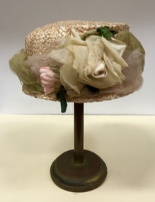 Kew Historical Society Inc
Headwear - Cream Straw & Silk Hat, L’Estelle, 1930s
In 1930, the business 'L'Estelle' is registered as operating at 107B Glenferrie Road, Glenferrie (Commonwealth of Australia Gazette No.99 (12 November 1930)The Kew Historical Society’s fashion and design collection is comprised of costumes, hats, shoes and personal accessories. Many of these items were purchased or handmade in Victoria; some locally in Kew. The extensive hat collection comprises items dating from the 1860s to the 1970s. While most of the hats in the collection were created by milliners for women, there are a number of early and important men’s hats in the collection. The headwear collection is particularly significant in that it includes the work of notable Australian and international milliners.Plain straw woman’s hat with a narrow brim covered with pale green and pink silk roses and net. Label: L’Estellel'estelle, women's clothing -- hats, headwear, straw hats -- 1930s -
 Flagstaff Hill Maritime Museum and Village
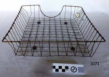
Tray
Wire in and out office tray used to hold papers from 1930s-1950sNone only as a curiosity for early office equipmentTray metal wire paper with curved section in front for hand space. On four round flat pads.Noneflagstaff hill, warrnambool, shipwrecked-coast, flagstaff-hill, flagstaff-hill-maritime-museum, maritime-museum, shipwreck-coast, flagstaff-hill-maritime-village -
 Ringwood and District Historical Society
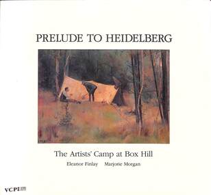
Book, Educational Media Services, Victoria College et al, Prelude to Heidelberg - The Artists' Camp at Box Hill, 1991
Image of a Tom Roberts painting on front of soft covered book titled The Artists' Camp at Box Hill - Eleanor Finlay, Marjorie MorganFOREWORD by William Dargie Kt., C.B.E., FRSA (London) FRAS (NSW) As one born between two worlds I find it difficult to identify wholly with either Australian art of the late 19th and early 20th centuries or the infinitely varied styles of today. At the beginning of the 1930s, when I first began to take any sort of interest in art, I had the natural feeling of youth that anything that had happened thirty to forty years ago was already far down the dark and backward abysm of time. As for today, all that one of my generation can do is to enjoy what is enjoyable and avert one's eyes and close one's ears against the rest. This is the time of life one realizes that distaste, as well as taste can be cultivated. Well, youth repeats itself in each generation and among the young there will always be .some determined and dedicated to the making of new images of the physical world. All artists throughout history have shared this common experience. All have remembered the suddenly-formed friendships, the sketching expeditions and camps, the first exhibitions, the formation of groups, the 'manifestos' - these last to return in later life all too often as embarrassments - but above all, the enthusiasm. 'Bliss was it in that dawn to be alive but to be young was very heaven'. Thus we can be time-travellers back one hundred and six years to that first plein-air camp set up by Roberts, McCubbin and Abrahams on part of David Houston's property at Box Hill. This was indeed the prelude to all that followed: Mentone and the meeting with the young Streeton painting on the rocks, and Heidelberg later. -
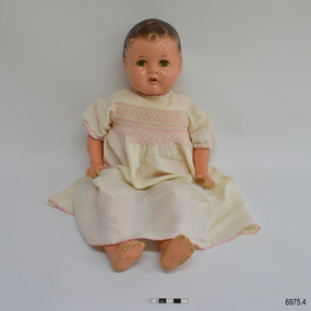 Flagstaff Hill Maritime Museum and Village
Leisure object - Doll, Reliable Toy Company Ltd, 1930s to 1940s
This dressed doll was owned by the daughter of Dr William Roy Angus and his wife Gladys when the family came to Warrnambool in the late 1930s. It is part of the W.R. Angus collection, donated by the family of Dr W R Angus, surgeon and oculist. The doll was donated with another dress and a blanket. The doll has features similar to, but an earlier model than, Reliable's 1940s model Cuddlekins doll, which has an entirely composite body. ReliableToy Company was founded in Toronto, Canada, by Solomon Samuels in 1920. Samuels was later joined by his two brothers. The company had a reputation for products of good quality. In 1922 the company began making their own dolls from composition, where previously the parts were made elsewhere and assembled by Reliable. The company stopped making Reliable dolls in 1995. The W R Angus Collection spans from 1885 to the mid-1900s and includes historical medical and surgical equipment and instruments from the doctors Edward and Thomas Ryan of Nhill, Victoria. Dr Angus married Gladys in 1927 at Ballarat, the nearest big city to Nhill where he began as a Medical Assistant. He was also Acting House surgeon at the Nhill hospital where their two daughters were born. Dr Angus and his family moved to Warrnambool in 1939, where Dr Angus operated his own medical practice. He later added the part-time Port Medical Officer responsibility and was the last person appointed to that position. Dr Angus and his wife were very involved in the local community, including the planning stages of the new Flagstaff Hill and the layout of the gardens there. Dr Angus passed away in March 1970.This doll is connected to the history of Warrnambool, as it was owned by the daughter of Dr W. R. Angus and his wife Gladys, and is part of the W.R. Angus Collection, which is important for still being located at the site connected to Doctor Angus, Warrnambool’s last Port Medical Officer. Dr Angus and his wife brought their young family to Warrnambool in 1939 and he remained a resident until his death in 1970. Early in his profession in the town of Nhill, Dr Angus assisted Dr Tom Ryan in his pioneering use of X-rays and in ocular surgery, and Dr Angus later inherited these items. The W.R. Angus Collection includes these medical instruments and other related equipment and is culturally and historically significant as an example of the medical practice of the late 19th to the mid-20th century. Other items in the collection relate to Dr Angus’ service in the Flying Doctor Service and the Army. The doll is also significant as an example of toys imported into Australia in the 1930s and 1940s and used by children in the Warrnambool community.Doll with moulded composition head, neck, arms and legs, all attached to a fabric body. The doll’s head has brown moulded curls. The facial features include an open mouth showing two top teeth, green eyes, and sleeping, closing eyelids with eyelashes. The doll has a crier inside that makes a sound when the doll is turned over. It is clothed in a knitted pink singlet, modern pink underwear, and a cream flannel short-sleeved dress with pink smocking and embroidery, and ties at the rear. There is a moulded inscription on the back of the doll’s head. The doll was made by Reliable Toy Company Ltd, Canada. The doll is part of the W.R. Angus Collection.On the back of the head “RELIABLE / CANADA”flagstaff hill, warrnambool, maritime village, maritime museum, shipwreck coast, great ocean road, dr w r angus, dr roy angus, dr ryan, warrnambool oculist, port medical officer, mira hospital nhill, toy, nhill hospital, doll, baby doll, composition doll, reliable toy company, canada, solomon samuels, child's toy, w.r. angus collection