Showing 550 items matching "early settlement"
-
 Halls Gap & Grampians Historical Society
Map - Coloured
Background on Bridle Path up Stony Creek Gorge Pre 1840 C. B. Hall, squatter on Mokepilly Run 1841-1842, first European to discover the Fyans Creek valley, the entrance of which became known as Hall's Gap. He later recorded that he followed a number of tracks which he assumed had been made by the Aboriginies and described one as "leading up a wild romantic glen and over on to the source of the Glenelg River". This could well have been the route taken up Stony Creek gorge by the first timber-cutters in this part of the Grampians to the saddle between the Wonderland and Mt. Difficult ranges known as Valley Gap 1850s/60s Timber cutters and shingle splitters were reported to be moving into the eastern side of the Grampians and by the mid 1860s there were a number of families connected to the supplying of timber to Pleasant Creek living in the "Hall's Gap ranges". John Wakeham, the first store owner in Pleasant Creek in 1854, established a timer-mill in upper Stony Creek Gorge in the late 1850s. Wakeham is credited for the clearing and levelling of the first bridle-path up the gorge. 1870s By the mid 1870s the track had been extended over Valley Gap to the Victoria Forest (the upper region of the Victoria Valley). McKeon's bullock team was known to have hauled red gum from the Valley to Stawell in the late 1870s and the 1880s. 1880s In 1887 an article in the Pleasant Creek news describes the Stony Creek Gorge track as "being a ledge alongside the mountain range, formed in the early days with the aid of earth and timber, along which the bullock teams used to travel to Horsham and plains of the Wimmera beyond." 1890s Gold was discovered in the catchment area of Stony Creek and by the end of the 1890s a new track was built from "near the junction of Fyan's and Stony Creeks, up the gorge to the diggings settlement. The mining Department had paid L300 for its construction and, when completed, the track was "three miles and 30 chains in length, the side cuttings at the narrowest part being 10 feet between" and "the watercourses which cross the track at various points" having been "filled up with rocks rolled down the sides of the hills, and consequently there can be no damage caused by bushfires which destroyed the former wooden bridges erected on the old track to Wakeham's saw-mill, the remains of which are still to be seen at the side of the diggings" The article goes on to further describe the track as one which "can with ease travel with a two horse conveyance either up or down" and that the workmen engaged in the construction of the track would be attending "a ball that night at McKeon's farm near the mouth of the gap to celebrate the successful completion of the undertaking". 1900s At what time the bridle path was extended beyond Valley Gap to the Wartook basin on the Mt. Difficult Range has not yet been determined. However, it is known that, by the turn of the century, people were travelling between Halls Gap and the caretakers' residence at Wartook Reservoir along what was now known as the "Bluff Road. Wartook's embankment had been constructed in 1887 and at that time there was already a track from Rosebrook Station homestead (near the present day Wartook Pottery) to the reservoir. Philip Rose owned both Rosebrook and Wartook Stations from the mid 1840s to the late 1850s and had regularly leased the Wartook basin to Cobb & Co. to rest horses there. 1920s Following the war of 1914-1918, tourism really took off in the Grampians, and Halls Gap rapidly grew. People would travel as far as they could on the many tracks then hike to the many lookouts being discovered by local tour guides. This led to the need for access across the range so that horse riders and the increasing number of vehicles could travel between Horsham and Halls Gap. To this end, the Bluff Road was improved and extended on 1929 and at its opening in March, 1930, by Lady Somers it was renamed the Mt. Victory Road.Map of Mt Victory Road and othersaccess routes, mt victory rd, bridle path, roads -
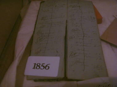 Heathcote McIvor Historical Society
Day Book, Book, 1856
Believed to be long to Routledge Brothers who ran a general store business in heathcote. They also owned a sawmill and quartz crushing battery.one of three books donated to the Museum, were found by the donors father back in the late 1960's while he was working on renovations to a building in heathcote these books had been thrown onto a pile of builders rubble, he retrieved them. when he passed away some years later his son found them while clearing out his effects, have travel through several house changes till 2010 when the son was doing a cleanup and the books were found again he contacted the Historic Society, date back to first settlement of Heathcote, inside writing is in excellient condition, as if it were written yeaterday. give a daily account of purchases by locals.gives us an insight into persons living and working in Heathcote McIvor district. Not many early items of this era left .Day book, oblong, leather cover, Day book gold blocked on front coverday book routledge, brothers -
 Eltham District Historical Society Inc
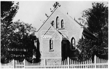
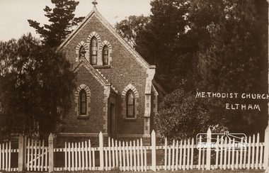
Photograph, Eltham - Methodist Church (1880)
RERVISED STATEMENT OF SIGNIFICANCE, CONTEXT, 2010 What is significant? The 1880 bichromatic brick church and the surrounding site to the title boundaries. How is it significant? The church is architecturally, historically, socially and spiritually significant to the Shire of Nillumbik. Why is it significant? The church is architecturally significant as a finely detailed example of a brick 19th century rural community church, one of only four in the Shire (Criteria E & B). The church is historically significant as an important link with the time when Eltham was a small, insular country settlement. Also for the historical evolution visible in the complex, with the modest 1880s church and larger red brick rear hall from the early 20th century as a reflection of population growth in the area (Criterion A). The church is historically, spiritually and socially significant because it has played, and continues to play, an important part in the spiritual and social life of the community (Criterion G) - Victorian Heritage Register. This photo forms part of a collection of photographs gathered by the Shire of Eltham for their centenary project book,"Pioneers and Painters: 100 years of the Shire of Eltham" by Alan Marshall (1971). The collection of over 500 images is held in partnership between Eltham District Historical Society and Yarra Plenty Regional Library (Eltham Library) and is now formally known as the 'The Shire of Eltham Pioneers Photograph Collection.' It is significant in being the first community sourced collection representing the places and people of the Shire's first one hundred years.Digital image"Methodist Church"sepp, shire of eltham pioneers photograph collection, eltham, methodist church -
 Kiewa Valley Historical Society
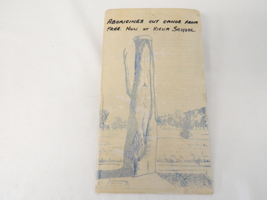
Sketch Tree Bark, Aboriginal - bark removed from tree
This sketch of a tree whose bark was cut, by aboriginal craftsmen, to produce a canoe for fishing in the rivers running through the Kiewa Valley either before or just after the 1800's. The tree trunk depicted in the sketch would have been used at the beginning of European settlement in the Kiewa Valley or just before contact was made.As this sketch was of a tree found along the Kiewa River it indicates that Aborigines lived by the river. This sketch depicts the usage of tree bark by the Aboriginal fisher person in crafting a canoe to cross rivers and to fish in the deeper sections of the river course.This freehand sketch detailing the outline of bark removed to provide a canoe is in ink portraying a tree trunk with one branch which has a plaque in front a gravel section to the right and open fields in the mid background and scattered trees on a hill slope in the far background. The sketch is on thick cardboard with a plastic protective cover over it (fastened on the flip side). It is a sketch of the tree now exhibited at the Kiewa Consolidated School.Written in black ink on the top section (heading) "ABORIGINES CUT CANOE FROM TREE. NOW AT KIEWA SCHOOL"crafted canoe, aboriginal craftsmanship, tree usage, early aboriginal craftsmen, kiewa river. kiewa consolidated school -
 Eltham District Historical Society Inc
Photograph, Hurstbridge shops, Heidelberg-Kinglake Road, opposite Hurstbridge Railway Station, Eltham Heritage Tour, 24 May 1992, 24/05/1992
ELTHAM HERITAGE TOUR The Society excursion on 24th May 1992 was arranged by David Bick, leader of the team carrying out the Shire's heritage study. David selected a number of sites or buildings identified in the study, some of them lesser known components of the Shire's heritage. The tour commenced at the Eltham Shire Office at 10.00 am. Travel was by private car and mini-bus with stops at about twelve locations for commentary by David.It included a short walk in Hurstbridge and lunch at Kinglake. Highlights of the tour included: - 10 am Leave from Shire Offices - 3 Important Trees - A Physical Link to Eltham's First Settlers - Toorak Mansion Gates - A Surviving Farm House - An Intact Circa 1900 Main Street - First Settlers - Gold Miners, and Timber-getters - An Early Hotel - A Pioneering Homestead - Changing Eltham Shire - 20th Century - 4 pm Afternoon Tea and Finish Tour Extract from ELTHAM CULTURAL HERITAGE TOUR (Newsletter No. 85, July 1992, by Bettina Woodburn) "Leaving the cars at Hurstbridge we walked the main street of the old village settlement, now a suburb. Near the station was a fine Edwardian house complete with palm and pines. Opposite was the Police Station, 1930-60 with a portable lock-up behind and the residence beside it. No. 794 was the Post Off1ce 3099 the-original shop-front window now has mail-boxes below. Close to the Railway entrance the butcher's shop remains unchanged, but across the road the linear shopping centre tries to keep the character of the olden times. The Fire Bell once hung on a tall gum outside No. 832. Palms in front gardens indicate the age of some of the homes, about 70 years. A corrugated iron shed still stands on the front fence line next to No. 840. Adding to the streetscape is an example of the standard timber early 20th century four veranda post suburban villa."Record of the Society's history and activities and highlighting various aspects of the Heritage Study undertaken by David Bick used to create the future heritage overlay for the Shire of Eltham and later Nillumbik Shire.Roll of 35mm colour negative film, 4 stripsKodak Gold 100 5095shire of eltham historical society, activities, heritage tour, hurstbridge, shops -
 Eltham District Historical Society Inc
Photograph, St Andrews Primary School, Eltham Heritage Tour, 24 May 1992, 24/05/1992
ELTHAM HERITAGE TOUR The Society excursion on 24th May 1992 was arranged by David Bick, leader of the team carrying out the Shire's heritage study. David selected a number of sites or buildings identified in the study, some of them lesser known components of the Shire's heritage. The tour commenced at the Eltham Shire Office at 10.00 am. Travel was by private car and mini-bus with stops at about twelve locations for commentary by David.It included a short walk in Hurstbridge and lunch at Kinglake. Highlights of the tour included: - 10 am Leave from Shire Offices - 3 Important Trees - A Physical Link to Eltham's First Settlers - Toorak Mansion Gates - A Surviving Farm House - An Intact Circa 1900 Main Street - First Settlers - Gold Miners, and Timber-getters - An Early Hotel - A Pioneering Homestead - Changing Eltham Shire - 20th Century - 4 pm Afternoon Tea and Finish Tour Extract from ELTHAM CULTURAL HERITAGE TOUR (Newsletter No. 85, July 1992, by Bettina Woodburn) "At St Andrews we noted the old and new schools, the Anglican Church, the Hall, the Bakery and the pub – still a popular watering and eating place. Climbing towards Panton Hill the soil was not rich and supported only scarce growth. Perfunctory prospecting and mining had taken place in this area, though not with the diligence applied at Research. Again we saw the ingredients of a settlement, this one organised by Government, the Hotel, the Store, the School. Down from Memorial Park the School grounds had original tree planting and the School Bell dedicated to Maud Rattray who died in 1922. There is a new Hall and opposite in the grounds of the Church and Sunday School a modest Memorial Cross of granite with inscriptions and in memory of four 'fallen comrades'. This small section of the main road retained the small village atmosphere; although the population had increased there had been little alteration."Record of the Society's history and activities and highlighting various aspects of the Heritage Study undertaken by David Bick used to create the future heritage overlay for the Shire of Eltham and later Nillumbik Shire.Roll of 35mm colour negative film, 4 stripsKodak Gold 100 5095shire of eltham historical society, activities, heritage tour, st andrews -
 Eltham District Historical Society Inc
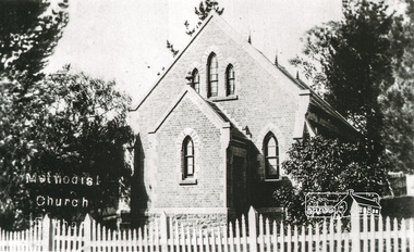
Photograph, Tom Prior, Methodist Church, Eltham
Situated at 810 Main Road on the corner of John Street. The Church was surrounded by a picket fence and tall pine trees. The Church was built by George Stebbings in the 1850s and is an example of fine craftmanship. Formerly Wesleyan, Methodist then Uniting church; the foundations of the church building were constructed with stone from the walls of the first Eltham State Primary School (No. 209) building which collapsed in 1874 and were purchased by Robert David Taylor. The Reynolds/Prior Photograph Collection, Presented to the Eltham District Historical Society, 14 June 2006 by Ross McDonald. A second copy was also presented to the Andrew Ross Museum, Kangaroo Ground The Reynolds family were early settlers in Research. Reynolds Road is named after this family. RERVISED STATEMENT OF SIGNIFICANCE, CONTEXT, 2010 What is significant? The 1880 bichromatic brick church and the surrounding site to the title boundaries. The church is architecturally, historically, socially and spiritually significant to the Shire of Nillumbik. Why is it significant? The church is architecturally significant as a finely detailed example of a brick 19th century rural community church, one of only four in the Shire (Criteria E & B). The church is historically significant as an important link with the time when Eltham was a small, insular country settlement. Also for the historical evolution visible in the complex, with the modest 1880s church and larger red brick rear hall from the early 20th century as a reflection of population growth in the area (Criterion A). The church is historically, spiritually and socially significant because it has played, and continues to play, an important part in the spiritual and social life of the community (Criterion G). - Victorian Heritage Database The Reynolds family were early settlers in Research. The Reynolds/ Prior collection of photographs were taken by Tom Prior, the maternal uncle of Ivy Reynolds, around 1900 and the 60 photos in the album give a fine overview of many of the landmarks of Research and Eltham over 100 years ago. lvy lived in the family home for many years at 106 Thompson Cres Research. Ivy's father, Ernst Richard Reynolds and grandfather, Richard Reynolds, lived at the same address. Ivy's father Richard worked for Mr. Trail on his property in Research. Reynolds Road is named after the family. Mr Tom Prior (wife Eva) worked at the Melbourne zoo. He was very innovative and made his own camera, using the black cloth hood to exclude the light. The photographs are a reminder of the rural nature of Research and Eltham and its rich heritage. Black and white photograph mounted in an album, the Reynolds/Prior Photograph Collection, this being one of 53 reproduced black and white images of early Eltham."Methodist Church" reynolds prior collection, eltham, methodist church -
 Kiewa Valley Historical Society
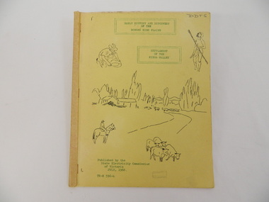
Book - Bogong High Plains x2, Early History and Discovery of the Bogong High Plains, 1968
The State Electricity Commission of Victoria constructed the Kiewa Hydro Electric Scheme in the north east of Victoria. Mr R.M. Duncan prepared the notes. He was a member of the S.E.C. Kiewa Branch from 1949 - 1966. This book was commissioned by the State Electricity Commission of Victoria. It consists of the early history of the Bogong High Plains and the origin of names of places and creeks in the area.This book was researched in 1968 by Mr R.M. Duncan who worked for the S.E.C. on the Kiewa Hydro Electric Scheme from 1949 to 1966. His sources were the Melbourne Public Library, the Victorian Historical Society, the North Eastern Victorian Historical Society and the Dept. of Crown Lands & Survey, Melbourne. The book is an accurate history of the Bogong High Plains given the available records at the time. Yellow cardboard covered book with black sketches and green print. 9 one-sided pages held together by 3 staples and taped over the staples. One - has sheets enclosed "The Three Floras of Bogong" and "General Geology of the Kiewa Area". 6 copies including 1 that is a photocopyDDTS hand written on front cover "Early History and Discovery / of the / Bogong High Plains" on cover top centre. "Settlement / of the / Kiewa-Valley" on cover towards the top slightly to the right. "Published by the / State Electricity Commission / of Victoria / July, 1968" on cover bottom left. "TR-K 596-4" on cover bottom left.bogong high plains. state electricity commission of victoria. kiewa. aborigines. kiewa valley. mullindollingong pastoral run. flora. geology -
 Kiewa Valley Historical Society
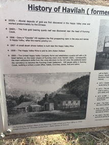
Papers - Havilah Cemetery, Havilah Cemetery Formerly Running Creek Cemetery
In 1889, 24 residents of the Running Creek and surrounding district submitted a petition to the Minister of Lands, Melbourne requesting land for a cemetery. Their request was granted. The Cemetery was decommissioned in the early 1950s and the last trustee for the cemetery died in 1986. There is a wooden fence around the boundary (May 2024). One paper lists 29 names in the Burial Register 1861-1948. The last two sheets record the history as a timeline from the 1850s to the 1900s. Havilah was a gold mining settlement from the 1850s located 20km west of the Kiewa Valley and in the Ovens catchment near Myrtleford.Five black and white A4 pages stapled together. Copies of the sign erected at the gate of 'Havilah cemetery formerly Running Creek Cemetery'. Also the 'History of Havilah formerly Running Creek'havilah, running creek, cemetery -
 Kiewa Valley Historical Society
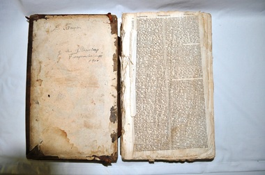
Bible - Family, Brown's Superb Bible, circa early 1800's to 1900
This item represents one of the most important spiritual references available to a settler in countryside Australia in the period 1800s to 1900s. This is the family bible and relates to the major religious beliefs of the early settlers who pioneered British/European colonial settlements. Although the first pages are missing the family name is written on the inside cover (J.A. Fleming). Most of these bibles (of this era) showed the family genealogical record of births, baptism and deaths, however this bible has the relevant pages missing. This bible would have provided the spiritual strength needed in bad times. Throughout this bible there are copies of specially commissioned lithographic engravings, each published between March 1812 to December 1813. These photographs were provided to visualise the theme of the each chapter.This item is significant because it shows that spiritualism of a small group (family in this case) is a vital part of the cohesive forces which holds a family(the basic subgroup of society) together, against all odds, and external pressures. It demonstrates that even in isolated or sparsely populated areas, the mores of a christian community is as strong as that of the cities. Mountains (Victorian Alps) have throughout the enlightened Ages been of extreme spiritual significance and this beholds those who live in this area.The families in the Kiewa Valley fall into the "isolated rural area" when this bible was first in use. This bible contains as its introduction,scripture history starting from 4004 BC "God created all things" to 2900 AD end of the World. There is a high degree of probability that this bible belonged to a member or members of the John Ambrose Flemming extended family who resided in the Kiewa Valley. J.A. Flemming (a famous English electrical engineer and physicist) invented the first diode in 1904). He and his family were devout Christians and he helped establish the Evolution Protest Movement.Leather bound bible. Leather in some areas is in tatters revealing the thick multi-layered cardboard backing. Front and back covers are held together by the thin leather binding. The lettering of the bible is large.Hand written inscriptions are in ink on the inside front cover, " J Tangam" at the top, "J A Fleming" underneath "Tangambalanga" and below that "1900". There are penciled dates "1937 1900" which have at one point in time been scribbled over in pencil. Although not marked on cover, the bible was known as "Brown's Bible" after the Author, the Rev. John Brown. Each of the major chapters is introduced by a copy of a lithographic print detailing the relevant religious picture and all are headed by "Brown's Superb Bible" and the date of the print. bible, rev. john brown, old and new testament, christianity -
 Kiewa Valley Historical Society
Book - Non Fiction History, The Kiewa Story, circa 1993
This book provides in chronological order the development of the Kiewa Hydro-electricity scheme from the first concept (1911) to final construction work (1961). It covers the first attempt to utilise the power of the Victorian Alps water system. It started from a private syndicate and developed to the current State Electricity Commission of Victoria. The incentive for the Hydro scheme was to make money and not as an alternative to the carbon producing coal fired power plants. These coal fired power plants were increasing in numbers to service an ever increasing demand made by population expansion, especially in cities and large rural settlements. This demand spiraled up after World War II when there was a tremendous spike in immigration numbers due to refugees and displaced persons in Europe. The ability to utilise the untapped water provided by the winter snow fields, for a higher yield in electricity, was a powerful incentive to overcome the physical hardships in this remote Alpine region. Future power requirements may initiate the re-installation of the other two power stations(Pretty Valley and Big Hill) covered in original Scheme. This publication not only covers the development of the Kiewa Valley region with respect to population (within a socio-economical framework) but also the subtle but yet strong physical changes of a relatively pristine alpine region. The demands that an ever growing regional population places on the environment is clearly documented in print and black and white photographs. The working and living conditions of those who constructed and gave life to this hydro scheme is well documented in this book. It may be viewed as spartan now but was relevantly good at that moment in time, especially for those workers fleeing a devastated European environment. The successful planning and consideration to minimising any intrusion upon the natural alpine forests and high plains can viewed as an example (compared to the Tasmanian Hydro schemes) of how future hydro schemes (an inevitable requirement) will proceed. Most rural towns (in the early 1900s) were built by unencumbered rural based citizens, with the exception of Mount Beauty and Falls Creek. These two settlements were brought into life by a State (Victorian) Authority for a specific function and program. They were a gated community, that is, only open to construction workers involved with the hydro scheme. All facilities within these communities were provided by the State Electricity Commission of Victoria. The impact on the social, financial and individual independency of the community, by the transition from the S.E.C .environment to one of local government (Shire of Bright), had in some cases a severe impact.This hard covered book has a green cover with pictures on the front and back covers. The front cover has a coloured picture of a snow covered Mount Bogong taken from the opposite mountain range. The valley between both ranges has a whisk of mist over it. At the bottom of this picture are three black and white photographs covering the construction of the Kiewa Hydro - Electricity Scheme. On the back cover is a photograph, (black and white) detailing the Bogong village and Junction dam containing lake Guy. The inside front cover is a black and white photograph which details the construction of the West Kiewa tailrace tunnel during April 1951. The inside back cover is a black and white photograph of the concrete pour at the Clover Dam circa 1952. All photographs and sketches are in black and white. The pages are approximately 160 g/m2 and those which have photographs are on gloss paper.Book spine: "The Kiewa Story Graham Napier Geoff Easdown" alongside this is a white framed circle with white spokes radiating out and underneath in white lettering SECkiewa valley, hydro scheme, victorian alpine region, electricity generators, graham napier, geoff easdown -
 Eltham District Historical Society Inc
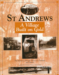
Book, St Andrews Primary School Council, St Andrews: A Village Built on Gold : the history to present day of St Andrews and District compiled by St Andrews Primary School Council, 1998
This history of the Victorian town of St. Andrews (formerly Queenstown) and its surroundings was written to celebrate the 140th anniversary of St Andrews Primary School. Describes the displacement of the Aboriginal inhabitants of the area, European settlement and the Gold Rushes and the Caledonia diggings. Discusses establishment of the school, church and cemetery and various other notable events. The school in 1998 and speculations on the future by primary school pupils. Contents: Introduction The First People Mining- What a rush! The School The Church Queenstown Cemetery The Hotels The Police Paddocks The Families Queenstown in the early twentieth century The Queenstown Bush Fire Brigade The 1st Queenstown Scout troop Queenstown, the 1940s and 1950s The Characters Odds and Sods St Andrews - The Present Times The Future St Andres Primary School in 1998This book is significant in that it documents the history of the St Andrews community from the indigenous presence through its foundation during the Victorian Gold Rush through to local bushfires and predictions of the future by local primary schools students in 1998. It remains the only significant secondary source publication written specifically on this rural community.158 p. : ill., ports ISBN 0646353756st andrews, queenstown -
 Eltham District Historical Society Inc
Photograph, Eltham Methodist Church, 1909, 1909
Situated at 810 Main Road on the corner of John Street. The Church was surrounded by a picket fence and tall pine trees. The Church was built by George Stebbings in the 1850s and is an example of fine craftmanship. Formerly Wesleyan, Methodist then Uniting church; the foundations of the church building were constructed with stone from the walls of the first Eltham State Primary School (No. 209) building which collapsed in 1874 and were purchased by Robert David Taylor. REVISED STATEMENT OF SIGNIFICANCE, CONTEXT, 2010 via Victorian Heritage Database What is significant? The 1880 bichromatic brick church and the surrounding site to the title boundaries. How is it significant? The church is architecturally, historically, socially and spiritually significant to the Shire of Nillumbik. Why is it significant? The church is architecturally significant as a finely detailed example of a brick 19th century rural community church, one of only four in the Shire (Criteria E & B). The church is historically significant as an important link with the time when Eltham was a small, insular country settlement. Also for the historical evolution visible in the complex, with the modest 1880s church and larger red brick rear hall from the early 20th century as a reflection of population growth in the area (Criterion A). The church is historically, spiritually and socially significant because it has played, and continues to play, an important part in the spiritual and social life of the community (Criterion G).Sepia postcard of Eltham Methodist Church, 1909eltham, methodist church, church, state school no. 209, eltham state school, robert david taylor, eltham uniting church, uniting church, wesleyan church -
 Warrnambool and District Historical Society Inc.
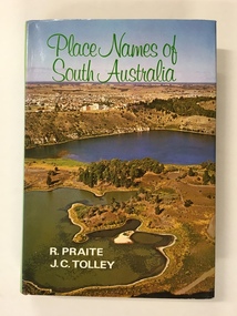
Book, Place Names of South Australia, 1970
This book gives information on the place names of South Australia and the origins of the names. It was compiled by Ronald Praite and John Tolley in 1970 and so is somewhat out of date as more place names would have to be added today. European settlement began in South Australia in 1836.This book is of minor interest to those in the Warrnambool area and may be useful for those researchers whose families have some connection to early South Australian history. This is a hard cover book of 208 pages. The cover is dark red with the names of the book and the authors on the spine. The dust cover has a colour photograph of a South Australian panorama on the front and a plain green back cover. The book has a Foreword, Sources of Reference, Acknowledgements, Introduction and an alphabetical listing of South Australian place names and the origins of the names. There are many black and white photographs supplied by the South Australian Tourist Bureau. There is some colour fading on the dust cover.Front Cover: ‘Place Names of South Australia’ ‘R.Praite’ ‘J.C.Tolley’ history of south australia, place names of south australia, ronald praite, john tolley -
 Warrnambool and District Historical Society Inc.
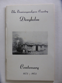
Booklet, The Temiangandeen Country Dergholm, 1973
This booklet gives information on the settlement of Dergholm at the time of the centenary of its founding, 1973. The origin of the name Dergholm is unclear but it may have Irish connections. Europeans came to the area in the 1840s and 50s but it was not until the 1870s that the town was surveyed. Dergholm is in the far west of Victoria 334 kilometres from Melbourne and nearby is Dergholm State Park established in 1982. The booklet was produced for the Centenary Back to Dergholm Committee and the local centenary celebrations. This book is of some interest as it provides information on Dergholm, a settlement in the far west of Western Victoria. This is a soft cover booklet of 52 pages by Alistair Roper. It has a cream-coloured cover with a black and white photograph of early Dergholm on the front cover (Edward Quinn’s house). The booklet has printed material - a President’s Message, an Author’s Note, Acknowledgements, Contents, information on the Dergholm area, including a list of local birds, and References. There are several black and white photographs of the area and its people. The book is stapled. Front Cover: ‘The Temiangandgeen Country, Dergholm Centenary, 1873-1973’dergholm victoria, alistair roper, history of western district of victoria -
 Warrnambool and District Historical Society Inc.
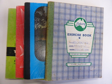
Booklet, Allansford Progress Association, Second half of 20th century
These four exercise books give documentation on the activities of the Allansford Progress Association (1966 to 1988). Allansford is a settlement about 9 kilometres from Warrnambool and most of the town area is now within the boundaries of the Warrnambool City Council. The association was re-formed in November 1966 after the demise of an earlier group. The members of the group campaigned in areas of local concern – T. V. reception, drainage and sewerage, postal services, sports facilities including the development of the Speedway, housing development, road proposals, waste management and disaster plans. These books are of interest in that they provide an overview of the history of a local organization. They will be useful for research. These are four exercise books - three Minutes books, and one Accounts book, from the Allansford Progress Association (1966-1988). The exercise books have coloured covers, (blue and white checkered, green, red and blue). Two are bound with tape and two are stapled. There are some loose sheets in all of the books. All the entries are handwritten. On front covers: ‘Allansford Progress Association’allansford progress association, history of allansford, history of warrnambool -
 Warrnambool and District Historical Society Inc.
Map - An Angler's map of the Hopkins River Estuary, Angler's map Hopkins River, 1980s
This is a map of the Hopkins River Estuary prepared by Dr John Sherwood for the benefit of anglers. The information on the sheet includes the location of sand banks, the water depths, boat ramp facilities and public access facilities. Some of the information has been gathered from aerial photographs. The map has been produced by the Warrnambool Institute of Advanced Education which was developed in the late 1960s from the tertiary section of the Warrnambool Technical College and with all its departments established by 1984 at the Sherwood Campus five kilometres from Warrnambool on the Princes Highway. Today the site is occupied by Deakin University, Warrnambool campus. The Warrnambool Anglers’ Club has its headquarters on the banks of the Hopkins River near the mouth of the river and the Lyndoch Aged Care facility.This map is of interest as a specialist one, providing fishermen with detailed information on all aspects of the Hopkins river estuary. Fishing has been both a profession and a popular recreational pursuit for Warrnambool residents since the early days of the city’s settlement. The Hopkins River Estuary has been a focal point for fishermen throughout Warrnambool’s history. This is a sheet of paper folded three times to produce a folded map. The front cover has a black and white photograph of two fishermen with a large fish. The map of the Hopkins River Estuary is in yellow, blue and black and covers the side of one sheet and three quarters of the other side. There is an advertisement for the Hopkins River Boathouse with a black and white sketch of the boathouse and notes on the map written by Dr John Sherwood. There are several diagrams showing the water depths. The map has some silverfish damage and some tearing at the folds. warrnambool anglers’ club, history of warrnambool, hopkins river, hopkins river estuary, john sherwood -
 Warrnambool and District Historical Society Inc.
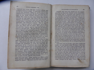
Book, Divine Conduct or the Mystery of Providence, Early to mid 19th century
... have of the very early days of Warrnambool’s settlement ...This is a book, ‘Divine Conduct or the Mystery of Providence’ originally written by the Rev. John Flavel in 1677. This is a later edition with no date listed but it is presumed it was re-published in the 19th century. The book was given to Janet McGhie in 1849, the first anniversary of the Warrnambool Sunday School, just 14 months after the first European settlers arrived in the new settlement of Warrnambool. The first Sunday School in Warrnambool was located in McDowell’s Store and run by Thomas Denney and Richard Osburne. The latter in 1851 commenced Warrnambool’s first newspaper, the Warrnambol Examiner and in 1887 published an important history of Warrnambool. Janet Garden McGhie was the daughter of Matthew and Isabella McGhie who were pioneer settlers in Warrnambool. Janet McGhie married Alfred Coulstock at the age of 17 and died in Warrnambool in 1918 at the age of 80. She was aged 11 when she received this book and one wonders what she made of the ponderous text. This book is very precious as one of the few mementos we have of the very early days of Warrnambool’s settlement. It gives us a date for the establishment of the first Sunday School and the name of one of the award winners. It is also an interesting example of the pious and ponderous writings that young children were expected to read in the mid 19th century. It is presumed that at that time there would not have been a great choice of reading material available in Warrnambool to give to childrenThis is a hard cover book of 252 pages. The dark green cover has gold lettering on the spine which is almost obliterated. The cover is partly detached from its binding and is much stained and blotched. There is an inscription on the inside front cover in black ink and a red stamp of the Warrnambool & District Historical Society on the first page. There are some indecipherable pencil markings on this first page and the last page.‘Janet McGhee (or McGhie), 1st Anniversary Warrnambool Sunday School, Decr 3rd 1849’janet mcghie, warrnambool sunday school -
 Warrnambool and District Historical Society Inc.
Document - Ledger: Warrnambool Shire Correspondence Letter Book, 1871-1875, Circa 1870
... and work covered in the early settlement days of the district ...A detailed continuum of correspondence showing the progress of development in the district and the co-operation and cost sharing between the different shires to have work completed. This collection of letters provides a very good overview of issues and work covered in the early settlement days of the district. Cover is brown watermarked patterned cloth with tan suede binding and corners. Inside front and back covers is green and red patterned paper. Alphabetical index at the front. The ledger contains copies of letters which were written to local shires and lands Departments and relate mainly to matters of infrastructure and local government charges There are a number of invoices at the back of the book.: Letter Book No. on spine. Gold lettering on red. Serial numbers, signatures, engravings, dedications in books, manufacturing details or personal markingswarrnambool, warrnambool shire, hampden shire, mount rouse shire, geelong to belfast road, alfred davies, 1873-1875, shire correspondence -
![Book, Nettie Palmer, The Dandenongs by Nettie Palmer, Melbourne : National Press, [1952]](/media/collectors/4f729f7997f83e0308601871/items/4f72b7f797f83e0308605830/item-media/4f72b7f897f83e0308605835/item-fit-380x285.jpg) Emerald Museum & Nobelius Heritage Park
Emerald Museum & Nobelius Heritage ParkBook, Nettie Palmer, The Dandenongs by Nettie Palmer, Melbourne : National Press, [1952]
Well known writer of Australian history and early setttlement of the Dandenongs.This item is significant of an example of the authors writing.Hard cover book of an account of the gradual settlement of the Dandenongs since the first white settler penetrated the wooded ranges more than a century ago. Author: Palmer, Nettie, 1885-1964. Illustrations: Edwards, Ron, 1930-2008.pioneers, settlers, dandenong ranges, raspberry growers, emerald, monbulk, nobelius -
 Emerald Museum & Nobelius Heritage Park
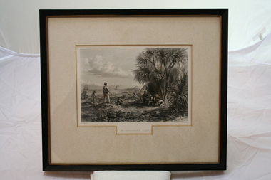
Relief prints, Thomas Baines et al, An Explorer's Camp, Circa 1875
From 'Australia' by Edwin Carton Booth. Thomas Baines joined Augustus Gregory as official artist and storekeeper, in the expedition across northern Australia between 1855-1857 sponsored by the Royal Geographical Society to evaluate the northern area of Australia for suitability as a colonial settlement. The Baines River was named after him.The item is socially and artistically significant as it is a very early image of Northern Australia.Framed black and white etching depicting a cap site located near the ocean.Artist T. Baines - J.J. Crew. From 'Australia' by Edwin Carton Booth. Thomas Baines joined Augustus Gregory as official artist and storekeeper, in the expedition across northern Australia between 1855-1857 sponsored by the Royal Geographical Society to evaluate the northern area of Australia for suitability as a colonial settlement. The Baines River was named after him.print, baines -
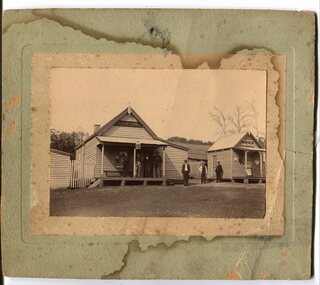
 Orbost & District Historical Society
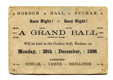
Document - ticket, 1896
Gordon Hall was the first public building in Buchan. European settlement first entered the area in October 1838 and Buchan station was established in January 1839. Free selection after 1868, and a township was proclaimed in 1873 taking its name from the station. The Grand ball was held on race night, Monday 28th December 1896 in the Gordon Hall at Buchan. From the estate of Elsie Cooke. Elsie Cooke was a librarian in Orbost for many years. She was the daughter of John Cooke early Brodribb settler. Elsie Cooke lived all her life in Gippsland,. She was born at Brodribb in 1895 and died in 1970, Elsie Cooke lived at Bruthen for a short time and, in 1937, moved to live with her aunt, Miss Jean Munro. Miss Cooke was Librarian at the Mechanics Institute for many years. Kindness and consideration for other were Miss Cooke’s attributes and she endeared herself to all who knew her. She was a loyal member of the Presbyterian Church and a stalwart of the Ladies’ Guild, an energetic worker for the Municipal Auxiliary and a member of the Red Cross. (ref. Mary Gilbert)This item reflects the recreational / social activities of a remote rural community. A public event such as a grand ball would have been a significant event on the calendar.Small, cream-coloured rectangular card with rounded edges and blank ink. Evidence of pin holes in each four corners and folds/signs of wear. Card is foxing and has small vertical tear in lower left quadrant.+ GORDON x HALL, x BUCHAN. + / Race Night! - Race Night! / A GRAND BALL / Will be held in the Gordon Hall, Buchan, on / Monday, : 28th : December, : 1896. / ADMISSION : / +- SINGLE, THREE SHILLINGS -+grand ball, 1896, gordon hall, buchan, elsie cooke -
 Orbost & District Historical Society
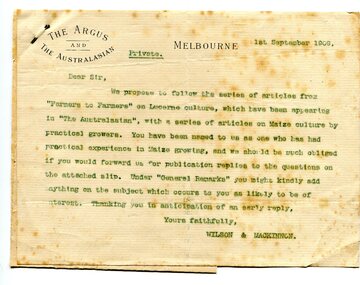
letter, September 1 1909
... in the Orbost district since early settlement. This item is associated ...When early settlers began to arrive on the Snowy River somewhere in the 1880s, the land was mostly swamps and heavily timbered jungle on the river frontages. The swamps were drained bit by bit using hand tools. The frontages were cleared by axe and shovel and fire. Several kinds of crops were experimented with such as hops, hemp and maize. Maize grew particularly well and became the main crop of the district. (info. from October 2006 ODHS Newsletter) The Argus was a morning daily newspaper in Melbourne, Australia that was established in 1846 and closed in 1957. It was considered to be the general Australian newspaper of record for this period.Maize-growing has been an important agricultural industry in the Orbost district since early settlement. This item is associated with that history.A typed letter sent to a local maize farmer requesting information on maize growing. The letter has the "Argus" letter head. The name of the recipient is unknown.maize agriculture-orbost correspondence-argus -
 Orbost & District Historical Society
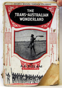
book, The Modern Printing Company, The Trans-Australian Wonderland, 1925
Born in 1893, Anthony Bolam was the Station Master at Ooldea Siding on the Trans-Australian Railway from 1920 to 1925. Bolam was very interested in Aboriginal culture and was a careful and sympathetic recorder of their lifestyle, customs and ceremonies. A keen photographer, he took many photographs of the Aboriginal people who congregated at Ooldea Siding in the early 1920s. Many of these photographs were included in this book. He died in 1966. This item is a useful research tool as it contains a contemporary description and photographsof the Aboriginal people of Ooldea, a tiny settlement in South Australia, on the eastern edge of the Nullarbor Plain. A small 134 pp book with a red and white cover which has a photograph of an Aboriginal holding a spear. The book has some full-page b/w plates and a folding map at the end.inside on front page - No. 58 -
 Orbost & District Historical Society
book, History of New South Wales, 1889
George Burnett Barton (1836-1901), lawyer, journalist and historian, was born on 9 December 1836 in Sydney. He practised journalism rather than law for which he had qualified in 1860. This is Volume 1 and covers the proposals for colonising New South Wales, the transportation and the early years of Governor Phillip.This is a detailed history of New South Wales compiled from original records and is a very useful research tool.A hard cover 625 pp book with a dark brown cover. On the spine the text is gold. It is titled, "History of New South Wales from the Records, Volume 1". It contains illustrations, facsimiles, maps, portraits and detailed historic information.Vol 1 1783-1789 Bartonnew-south-wales-history convict-settlement phillip-arthur barton-george-burnett -
 Orbost & District Historical Society
ginger jar, Pre 1893 floods in Orbost
... belonged to the very early settlement days of Orbost. ceramics ...In the early days of Orbost many Chinese were engaged in land clearing or had arrived when gold was discovered in East Gippsland in the 1840's. They lived in camps along the Marlo Road and houses were usually built on stilts. They left after the 1893 floods.This object has aesthetic appeal. It is an object which belonged to the very early settlement days of Orbost.Huge, ornate Chinese ginger jar. Four raised hand- painted pink roses on front. Jar itself is matt black. Looks more like a vase than a ginger jar. Ceramic.Some Chinese writing to left hand side of roses.ceramics, ginger jar, container - domestic, vase -
 Orbost & District Historical Society
black and white photograph, January 1901
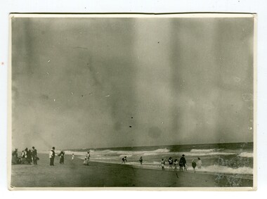
This photograph was taken at the "old station" at Corringle near Orbost. It was a popular picnic spot. Late in 1857 Mr Thomas T. Stirling took over Corringle Run ("Corringle" means "shallow water"). Mr Stirling and his family came from the wester district - Winchelsea. He settled at the Old Station. A few people were employed at the Orbost Stationb and there was settlement on the Orbost flats, Mr T. T. Stirling held the land from Lake Tyrers to Bemm River as a cattle run. About 1888 he became Secretary of the new Tambo Shire.This is a contemporary pictorial record of rural family life in Orbost in the early 20th century.A black / white photograph showing people on a beach with some in the water. those on the sand are dressed formally - men wearing suits and hats, the ladies in long dresses and hats.on back - "Picnic at OLD STATION Jan 1901"orbost-station orbost-family-life recreation -
 Orbost & District Historical Society
black and white photograph, early 20th century
The hotel at Bonang was also known as Clancy's Hotel, Bonang, after its licensee, William Clancy. It operated from the late 1890s until early 20th century. William Clancy was aslo the postmaster at Bonang. A post office operated at Bonang from at least 1859. At the time Bonang was "a small, scattered collection of buildings marking the intersection of the Bonang Highway and the McKillops Bridge Road" ( from Regional Heritage Assessment 1996). As the mining activity declined the township became even smaller as many of the population moved to Orbost,, a larger settlement. This is a pictorial record of Bonang, a small settlement approximately 50 km north of Orbost. The buildings in the photograph no longer exist.A black / white photograph mounted on grey card. there are stains from water damage on the mount. It is a photograph of two single-storeyed timber buildings fronting a wide dirt road. On the right is the Bonang Hotel with four men in suits standing on a verandah. The building on the right is the Bonang Post Office and there are three men outside it. the photograph has been posed. on back - 'Grandma Clancy owned the hotel & Uncle Will had a gold mine which he worked"bonang bonang-post-office bonang-hotel clancy-william clancy's-hotel-bonang -
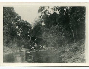 Orbost & District Historical Society
black and white photograph, C1890
... role in the early settlement of the Orbost / Marlo district ...This snagging team is on the Brodribb River, east of Orbost. The Brodribb bridge can be seen in the background of the Photograph. The Snowy River was used for commercial navigation after 1880 and extensive de-snagging A shipping company was formed in 1880, poling barges upstream until the removal of large trees and branches that had fallen into the river was carried out to make the river upstream of Marlo easier to navigate. "The snaggers played an important part in making the river free for transport. By 1880 Captain Collins, R McNair engineer, J McNair and the two Winchesters were at work with a punt on the Snowy and Brodribb. Mr. Jim Winchester took charge soon after. Early snaggers were Johnston, J Renton, Nat Lynch, John Drew, Hatton, J Scott and Harry Wilkinson. The system used was to use a tree on the river bank as a lever and with heavy manila ropes, slowly to haul the snags out. They were piled up around a tree and burned when dry. The snaggers lived in a row of cottages in Snaggers’ Lane." (info. John Phillips Newsletter March 2004)The snaggers played an important role in the early settlement of the Orbost / Marlo district helping bto open it up to commercial shipping.Two copies of a black / white photograph of nine men on a snagging boat, a flat-bottom barge. In the background is a bridge.on back - "Snagging boat on Brodribb with R.McNair"snaggers-brodribb-river snagging-east-gippsland transportation -
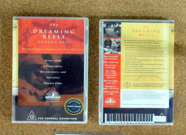 Orbost & District Historical Society
video, The Dreaming Reels, 1997
This disc was a project supported by the Festival of the Dreaming, a festival leading up to the 2000 Sydney Olympic Games.This disc is a significant research tool as it contains contemporary film of the early indigenous people of Australia.A video disc titled, The Dreaming Reels. it is a compilation of scenes from the Hadden expedition to the Torres Strait in 1898, Lake Tyers settlement, Northwest Scientific Exploration in the Kimberleys, the aboriginal camp at Orbost in 1921, the Douglas Wylie Expedition in 1926, Princess Charlotte Bay 1926-1927 and McRobertson's Expedition. It also contains footage from several Australian films depicting Aborigines. aboriginal-history dreaming