Showing 461 items
matching eastern creek
-
 Whitehorse Historical Society Inc.
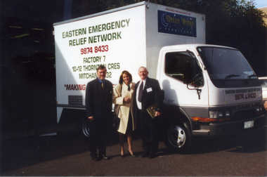
Photograph, Eastern Emergency Relief Network
The Nunawading Ladies Benevolent Society became the Whitehorse Emergency Relief Network in 1999 when a number of local organizations were encouraged to form a network by Betty and Keith Rooney. The object of the network is to collect domestic items to assist people in need, especially women who have been victims of domestic violence.Coloured photograph of Jim Jamieson, an unknown woman and Keith Rooney in front of a truck that was donated to the Whitehorse Emergency Relief Network by Mitcham Rotary and Jack Brockhoff of Brockhoff Biscuits. A sponsor of the Relief Network is the Dreamworks organization.eastern emergency relief network, jamieson jim, rooney keith -
 Whitehorse Historical Society Inc.
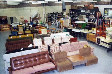
Photograph, Whitehorse Emergency Relief Network
The Nunawading Ladies Benevolent Society became the Whitehorse Emergency Relief Network in 1999, when a number of local organizations were encouraged to form a network by Betty and Keith Rooney. The object was to collect domestic items of good quality to assist people in need, especially women who have been the victims of domestic violence.Coloured photograph of the interior of the Whitehorse Emergency Relief Network 10-12, Thornton Crescent, Nunawading. Domestic goods showneastern emergency relief centre, thornton crescent mitcham nos 10-12 -
 Whitehorse Historical Society Inc.
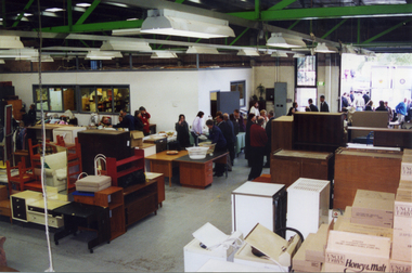
Photograph, Eastern Emergency Relief Network
The Nunawading Ladies Benevolent Society became the Whitehorse Emergency Relief Network in 1999 when a number of community organizations were encouraged to form a network by Betty and Keith Rooney. The object is to collect domestic items of good quality to assist people in need, especially women who have been the victims of domestic violence.Coloured photograph of the opening of the Eastern Emergency Relief Network, 10-12 Thornton Crescent, Mitcham on April 13 1999. Photograph shows people viewing donated goods.whitehorse emergency relief network, mitcham, thornton crescent no 10-12 -
 Whitehorse Historical Society Inc.
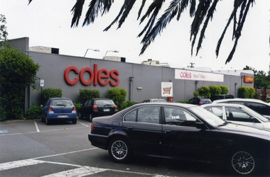
Photograph, Coles Supermarket, Mitcham
Coloured photograph showing part of the Coles Supermarket and the carpark on the eastern side of the building facing Mitcham Road.mitcham shopping centre, parking, car parks, coles supermarket, mitcham -
 Whitehorse Historical Society Inc.
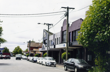
Photograph, Station Street Mitcham
Coloured photograph of the eastern end of Station Street, Mitcham, looking towards Whitehorse Road - 2012station street, mitcham -
 Whitehorse Historical Society Inc.
Photograph, Blackburn Library, 2012
Coloured photograph of the Blackburn Library on the eastern side of Blackburn Road. South Parade is oppositeblackburn branch library -
 Whitehorse Historical Society Inc.
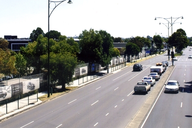
Photograph, Whitehorse Road, Blackburn, 2012
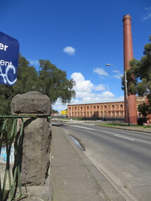
The property on the left of Whitehorse Road was once the Cottees factory. It later became the Leader Newspaper headquarters. It was next owned by Lexus Motor Sales and is now used (2014) as a storage yard with the eastern end used by Leader Newspaper as a staff car park.Coloured photograph of Whitehorse Road, Blackburn - 2012. Cars waiting to turn right into Surrey Road.whitehorse road, blackburn, roads -
 Whitehorse Historical Society Inc.
Photograph, Cook Family
William Cook was one of the earliest settlers in Vermont. Having returned from the W.A. goldfields he married Jane Maggs in 1880 at Wickliffe, Victoria and his only child, Amy, was born in 1881 at Box Hill. William Cook's property fronted Whitehorse Road, Mitcham and ran north almost to the Mullum Mullum Creek. He shared part of his eastern boundary with the Schwerkolt family. William Cook specialised in cherries and became known as 'The Cherry King'Sepia photograph mounted on card of a woman and a girl standing in front of a wooden house with iron lace on the verandah. A path leads down the side of the house.cook, amy, jane, orchards -
 Whitehorse Historical Society Inc.
Photograph, EastLink
... Whitehorse Historical Society Inc. 2-10 Deep Creek Road ...Series of coloured photos, commenced in 2005, of the EastLink project at the Deep Creek Road siteeastlink, thiess - john holland, deep creek road, mitcham, eastern freeway extension -
 Whitehorse Historical Society Inc.
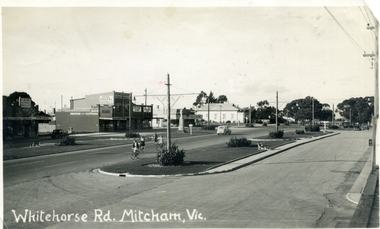
Postcard - Black and white postcard, Harold Millane, Whitehorse Road, Mitcham
Postcard: Black and white photograph of Whitehorse Road, Mitcham looking east from Station Street corner shops on eastern side and white heading 'Whitehorse Rd Mitcham, Vic.'Message written on reverse: see Media image.whitehorse road, mitcham, roads and streets, markham -
 Whitehorse Historical Society Inc.
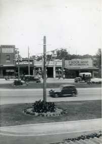
Photograph, Whitehorse Road, Mitcham
Black and white photograph of the shops on the eastern side of Whitehorse Roadwhitehorse road, mitcham -
 Whitehorse Historical Society Inc.
Photograph, Salvation Army Chinese Church, Mitcham, 2007
Coloured Photo of the Salvation Army Chinese Church on the north eastern corner of Mitcham and Harrison street, Mitcham.salvation army chinese church, mitcham, harrison street -
 Whitehorse Historical Society Inc.
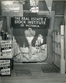
Photograph, Drake & Co Mitcham
During the period when the Armstrong family owned Drake & Co, Norman Armstrong became State President of the Real Estate and Stock Institute and son Raleigh, and later grandson Ian Armstrong were Presidents of the Eastern Suburbs Branch of the Institute and members of the State Council.Black & white photo of interior of Drake and Co, Real Estate Agents offices in Mitcham showing a Real Estate and Stock Institute of Victoria banners in full.;drake & co, real estate agents -
 Whitehorse Historical Society Inc.
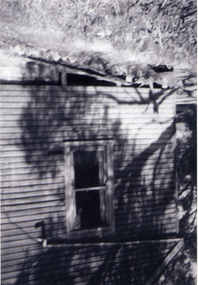
Photograph, Antonio Park - The Shack - East side, C1960
The photo is part of a set provided by Robin Harris of his early life (1953-1962) in 'The Shack' at Antonio Park. See ND5241 for his story 'When Antonio Park was home'.)Black & white photograph of the Shack in Antonio Park (1953-1962) showing the eastern side which faced Deep Creek Road. See ND5241 for history.antonio park mitcham, the shack, whitehorse road, mitcham, no.627, harris. robin, bushfire - 1962 -
 Whitehorse Historical Society Inc.
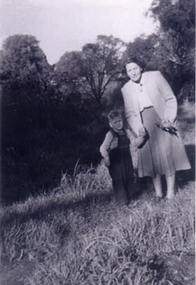
Photograph, Antonio Park - Doris Harris, C1960
The photo is part of a set provided by Robin Harris of his early life (1953-1962) in 'The Shack' at Antonio Park. See ND5241 for his story 'When Antonio Park was home'.)Black & white photograph of Doris Harris (1900-1975) with her grandson, and Robin Harris's nephew, Mark Coleclough. Photo was taken from the eastern side of the shack looking toward Deep Creek Road and showing part of the overgrown fruit orchard in the background. See ND5241 for history.antonio park mitcham, harris. dorothy, coleclough. mark, the shack, whitehorse road, mitcham, no.627, harris. robin, bushfire - 1962 -
 Ballarat Heritage Services
Photograph - Photograph - Colour, Sunnyside Mill Bridge over the Yarrowee, Hill Street, Ballarat, 2016, 17/09/2016
"A joint meeting of city and town ratepayers, convened by Messrs Francis Jago and Henry Johns, interested in the formation of a cart bridge in Hill street, over the Yarrowee Creek, was held on Saturday evening, in the Societies Hall, corner of Skipton and South streets, with the view of taking united action in the matter. Mr Morris was voted to the chair, : and about 60 persons were present. The chairman stated that the object of the meeting was that united influence should be brought to bear upon the City and Town Councils, so that a cartbridge should be erected. He said that Mount Pleasant would no doubt be thickly populated in a few years, and the bridge would prove a great boon to the inhabitants of the locality. By means of a cart bridge drays, would be enabled to save on their journeys to and fro between the mount and the batteries, at least a mile and a half each time. He hoped that the councillors for the south ward would assist them in this matter. Mr Jago, as one of the conveners of the meeting, said that united action on the part of both eastern and western ratepayers was requisite, so as to exert a strong pressure upon the City and Town Councils, in order that the work should be carried but. Mr Grainger moved the first resolution as follows;—“ That the construction of a cart bridge over the Yarrowee Creek at Sunnyside, to facilitate communication between the residents of the city and town, is urgently necessary, and that in the interests of both municipalities the two councils be asked to at once jointly carry out the work. In doing so he said that the necessity of a cart-bridge for the residents of Mount Pleasant would be apparent when the number of batteries, tanneries, and also the Woollen Mill, in the district were considered. The place was of growing import ance, and ready communication should at once be established. Another reason was that an immense saving in time would be effected. It was quite a common occurrence to see one, two, or three drays stuck in the bed of the creek which had gone that way to make a short cut. Now, what with the horses floundering about and breaking their harness, it seemed a wonder to him that life had not been destroyed before now, just through the want of a cartbridge. Mr Johns seconded the resolution. Mr Robert Calvert supported the resolution, and said that it was disgraceful action on the part of the representatives of the south ward that the work had not been executed long ago. They should come together like men and demand that the work should be done, and if not done they should not pay rates until it was. (A voice—“But they’ll make us.” Laughter.) The wooden footbridge across the creek was “only a wooden fabric, not fit for a Christian to walk across, and steps should be taken to remedy this also. Mr Blight, a resident of Mount Pleasant, said that, in common with others, he had been opposed to the erection of the bridge two years ago, but his views had since been altered. Cr. Morrison, who was present, said that the fault of the cartbridge not being erected over the Yarrowee at Hill street lay not with the City Council, but with their neighbors, who had always been opposed to its erection there. In 1874 a motion was carried at a meeting of ‘the City Council" by which the sum of £5OO had been voted to carry but the work. As the bridges over the Yarrowee were joint undertakings of the city and town, they had, by the provisions of an act of Parliament, called upon the Town Council to assist them in the erection of the bridge. In consequence, a conference of the two corporate bodies had taken place, when a motion was moved by Cr Howard, the representative of the south ward, and seconded by Cr Turpie, of Ballarat East—“ That the bridge should be erected at Hill street.” The motion was rejected, principally through the eastern representatives, who wanted the bridge lower down. Since then the two councils had often met to consider, the question of bridges over the Yarrowee Creek, but nothing had been done at the meetings, as the Eastern Council wanted the bridge in one place and the City Council in another. He had himself, when first elected to the council, given notice of motion affirming the desirability of a bridge, at the place now fixed upon. The Woollen Company was growing in importance, and a direct, road to its works would greatly advance its interests. For the working, expenses of each ward £400 was annually, appropriated; and this amount would not be sufficient carry out the work. They would have to obtain a special grant of about £900, as Hill street would require a culvert to be erected therein, as now it was virtually an open drain which carried the drainage of the western plateau to the Yarrowee. He advised that strong pressure should be exerted, specially upon the Eastern Council, and then the work might be carried out. He thought that if the foot bridge was repaired, and large stones thrown into the creek, it would do until the bridge could be erected. The chairman then put the resolution, and it was unanimously carried. Mr Hamilton moved the second resolution— “That Messrs Fern, Greenwood, Peirce, and Jago be deputed by the meeting to wait upon the City and Town Councils and present the first resolution; also that petitions in its favor be signed by all ratepayers interested.” Mr Haigh seconded the resolution, which was carried. Votes of thanks to Cr Morrison for his attendance, and to the chairman for presiding, were passed, and the proceedings terminated." (Ballarat Star, 9 August 1881, page 3) "WOOLLEN MILL BRIDGE YARROWEE IMPROVEMENTS Though brief the official ceremony of opening the bridge across the Yarrowee Creek, near the Sunnyside Woollen Mills, was of an interesting character. It took place at noon yesterday in the presence of the Mayors and councillors of the City and Town. Hon. F. Hagel thorn (Minister of Agriculture).Hon Brawn. M.L.C., Lt-Col Morton (Acting City Clerk). Mr J. Gent (Town Clerk of Ballarat East), Mr A. Farrer (City Engineer), Lt. L. Finch (who is about to leave for the Front, and who assisted Messrs A. Farrer and G. Maughan in carrying out the project, Mr W. Hurdsfield (Clerk of Works) and others. An apology was received from Mr J. McClelland, contractor for the work. Mayor Hill expressed pleasure in Introducing Mr Hagelthorn, who had at great personal sacrifice and inconvenience come from Melbourne to perform the opening ceremony of that beautiful bridge, which was of great improvements that had been effected.When Mr Hagelthorn was Minister of Pubic works he visited Ballarat specially to see the condition of the creek, which at that time was in a disgusting state from a sanitary standpoint. After viewing the position, and realising the justice of the claim. Mr Hagelthorn made strong representations to the Government of which the was a member with the result that it voted £17,000 for the work. That action had been the means of turning a plague spot into a thing of beauty. They therefore owed a deep debt of gratitude to Mr Hagelthorn and the Government of which he was a member, and they were particular grateful to Mr Hagelthorn for coming to Ballarat to perform the open ceremony. Mayor Levy said he could bear testimony to the good work Mr Hagelthorn had always done for Ballarat. In him Ballarat and district always had a good friend. He thought Mr Hagelthorn would feel amply gratified at seeing the good work that had been done. It would serve as some reward for the expenditure, on behalf of the residents of Bal larat, of the amount of money made available through Mr Hagelthorn's instrumentality for the two municipalities. Otherwise the City and Town councils would not have been able to carry out so necessary and so beneficial a work. There was a great amount of work yet to be done, and when the financial market became low stringent Mr Hagelthorn would no doubt be pleased to take the necessary steps to have money provided for further works which could not be undertaken at the present time. The adjacent woollen mill was a standing monument to what was being done in Ballarat, and what ever the City and Town Councils or the Government could do to encourage such manufacturing enterprise should be done, and he was glad to be able to say that was being done as far as finances would permit. He concluded by presenting Mr Hagelthorn with a gold mounted pocket-knife with which to cut the ribbon stretched across the centre of the structure as a bar to traffic. The Hon. F. Hagelthorn, who was greeted with applause said before him was a good work well done in the interests of the public. Real prosperity could only be achieved by a movement carried out by the people to increase natural productiveness. Most of them had been made aware, on account of the war par tiularly, that the people who were best equipped, the industries that were best organised, and the Governments that were most intelligently controlled would get the most of this world's goods and some of its luxuries that Would be denied other people less efficient. Any thing the Government could do to promote industry and to increase the reward of those engaged in it, both employer and employee, would be done. Most Governments would do but little in that regard. ... " (Ballarat Courier, 13 September 1916, page 4)Bluestone and iron bridge over the Yarrowee River at Hill Street, Ballarat.sunnyside mill, sunnyside woollen mill, ballarat woollen mill, bridge, yarrowee creek, francis jago, mount pleasant, yarrowee river, robert calvert -
 Whitehorse Historical Society Inc.
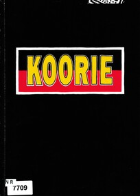
Book - Koorie Heritage Trust/ Museum Victoria, Creative Solutions, Koorie, 1991
The "Koorie" exhibition which opened in 1988 is devoted to over 40,000 years of Aboriginal cultural heritage in south eastern Australia and displayed in the Kershaw Hall, Museum of Victoria. This book provides details and photographs of the exhibition.This book describes the "Koorie" exhibition which is devoted to over 40,000 years of Aboriginal cultural heritage in south eastern Australia and displayed in the Kershaw Hall, Museum of Victoria.non-fictionThe "Koorie" exhibition which opened in 1988 is devoted to over 40,000 years of Aboriginal cultural heritage in south eastern Australia and displayed in the Kershaw Hall, Museum of Victoria. This book provides details and photographs of the exhibition.aborigines, museum victoria -
 Whitehorse Historical Society Inc.
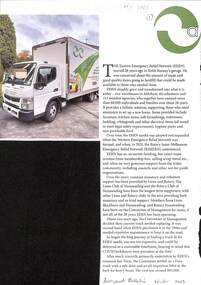
Newspaper - The Burwood Bulletin, Burwood Bulletin, New Truck Hits the Road, Winter 2023
... Whitehorse Historical Society Inc. 2-10 Deep Creek Road ...The Eastern Emergency Relief Network supports those in need to set up their home. It received a new truck in March 2023 with the help of funds collected by the local Lions and Rotary clubs.The Eastern Emergency Relief Network supports those in need to set up their home. It received a new truck in March 2023 with the help of funds collected by the local Lions and Rotary clubs.non-fictionThe Eastern Emergency Relief Network supports those in need to set up their home. It received a new truck in March 2023 with the help of funds collected by the local Lions and Rotary clubs.eastern emergency relief network, eern, rooney keith, lions club of nunawading, rotary club of nunawading -
 Southern Sherbrooke Historical Society Inc.
Information folder - Menzies Creek
Information folder containing items pertaining to the history of Menzies Creek. Contents: -document, "Menzies Creek, Now...And Then", by Pam Dennis, written for Eastern Regional Libraries History Writing Competition, 11 pages -single page from 'Australian Places' (Monash University), extracted 21st May 2004 -article, 'Following Tradition...', about Bill Hermon's retirement, The Trader, 19th July 1984, 2 copies -article, 'Museum draws first shots', re. the possible removal of the Puffing Billy Museum, Free Press, 9th August 1989 -article, 'There's gold in the Dandenongs!', re. Hancock's Nursery, Retirement, Issue 64, September 1998 -article, 'To remember...', re. Bill and Jean Hermon, Hills Trader, 1st August 1990 -article, 'Family honoured for community service', Free Press, 8th August 1990 -article, '30 years and still going strong', re. Puffing Billy, Knox-Sherbrooke Post, 29th July 1992 -article, "Daffodil delights", Free Press, 2nd Sep 1998, inc. photo of Rex Breen -article, 'People of the century', re. Hermon family, Ranges Trader Mail, 14th December 1999 -article, 'Pages from the past', re. the opening of John's Hill Reservoir in 1981, Ranges Trader Mail, 18th April 2000 -article, 'Historic reunion for family', re. Johns family, Ranges leader, 30th January 2002 menzies creek, gold-mining, timber, road transport, early settlers, menzies creek state school, puffing billy railway, st cuthbert's church, menzies creek rural fire brigade, menzies creek hall -
![Rear [inside] view of a brass lock with key from the Port and Harbours suction dredge 'Pioneer' used at the Queenscliff creek entrance](/media/collectors/4f729f7e97f83e03086018d1/items/5f855cde425f7f235017d662/item-media/612dad24e8448ba3f69e3419/item-fit-380x285.jpg) Queenscliffe Maritime Museum
Queenscliffe Maritime MuseumFunctional object - Lock, door, brass
The Argus Melbourne Friday 10 July 1908 QUEENSCLIFF, Thursday. - After a series of successful experiments in dredging the eastern end of the South Channel, the suction dredge Pioneer sailed this after-noon for the Gippsland Lakes, where work awaits her. During operations in the South Channel the dredge worked on a sandy and shell bottom in depths ranging from 35ft. to 40ft. with unqualified success, performing the work much quicker and cheaper than the bucket drudge John Nimmo, which is still employed. Captain Macarthur was in charge of the operations.Brass lock from Port and Harbours suction dredge 'Pioneer' used at the Queenscliff creek entrance door lock, suction dredge, pioneer -
![Scene near Corranderrk Station / [by] Nicholas Caire, circa 1876](/media/collectors/550653872162f11fb04854aa/items/57774ae0d0cdd10a5c12f2d7/item-media/57774b61d0cdd10a5c132dac/item-fit-380x285.jpg) Kew Historical Society Inc
Kew Historical Society IncPhotograph, Anglo-Australasian Photographic Company, Scene near Corranderrk Station, c. 1876
Nicholas Caire was born on Guernsey in the Channel Islands in 1837. He arrived in Adelaide with his parents in about 1860. In 1867, following photographic journeys in Gippsland, he opened a studio in Adelaide. From 1870 to 1876 he lived and worked in Talbot in Central Victoria. In 1876 he purchased T. F. Chuck's studios in the Royal Arcade Melbourne. In 1885, following the introduction of dry plate photography, he began a series of landscape series, which were commercially successful. As a photographer, he travelled extensively through Victoria, photographing places few of his contemporaries had previously seen. He died in 1918. Reference: Jack Cato, 'Caire, Nicholas John (1837–1918)', Australian Dictionary of Biography. The 1860s marked the beginning of the era of reserves and missions. Six Aboriginal reserves were established during the 1860s. These were under the control of the Board for the Protection of Aborigines. Four were Christian missions receiving government aid. These were Lake Tyers (Anglican) and Ramahyuck (Presbyterian/Moravian) in eastern Victoria for the Gunai/Kurnai clans; Ebenezer (Moravian) in north-west Victoria for the clans of the Wimmera and Lower Murray; and Lake Condah (Anglican) in south-west Victoria. The other two were secular government controlled reserves: Framlingham which, like Lake Condah, was established for the Mara-speaking Gunditjmara and Kirrae-wurrung people of south-west Victoria; and Coranderrk, located about 60 kilometres north-east of Melbourne, for the Kulin clans of central Victoria. In 1863, after a period of devastation to the Kulin people, Coranderrk was established at the junction of the Yarra River and Badger Creek. Reference: http://coranderrk.com/, accessed 24 December 2016An original, rare photograph from the series 'Views of Victoria: General Series' by the photographer, Nicholas Caire (1837-1918). The series of 60 photographs that comprise the series was issued c. 1876 and reinforced a neo-Romantic view of the Australian landscape to which a growing nationalist movement would respond. Nicholas Caire was active as a photographer in Australia from 1858 until his death in 1918. His vision of the Australian bush and pioneer life had a counterpart in the works of Henry Lawson and other nationalist poets, authors and painters.Albumen silver photograph mounted on boardprinted in ink on support l.c.: SCENE NEAR "CORRANDERRK" STATION. / COPYRIGHT REGISTERED. printed in ink on support reverse c.: VIEWS OF VICTORIA. / (GENERAL SERIES.) / No. 9. / SCENE NEAR "CORRANDERRK" STATION. / This scene was taken from the hill near Rourke's Bridge, on the Healesville Road, and displays in the foreground / the River Yarra. The roadway which is seen in the mid-distance has lately been constructed by the Government, / as the old tracks which formerly existed, were liable to be swamped by the periodical overflowing of the River. Mount / Ridell can be seen in the extreme distance immediately behind the roadway. / Corranderrk is the local habitation / for the natives of this district, and is situated on the right hand side of the picture, about a mile and a half / from the roadway. printed in ink on support reverse l.c.l.: J.W. FORBES, Agent, printed in ink on support reverse l.c.: ANGLO-AUSTRALASIAN PHOTOGRAPHIC COMPANY, MELBOURNE. printed in ink on support reverse l.c.r.: 10 Temple Court, Collins Street West.nicholas caire (1837-1918), coranderrk aboriginal station, aborigine, yarra river, badger creek, first peoples, aboriginal and torres straight islander -
 Kew Historical Society Inc
Photograph - Flooding of the Yarra Valley at Kew East, 1974
Flooding of the Yarra Valley, including that section of the Yarra bordering Kew and Kew East in the north and west of the municipality, was a regular occurrence. Extreme flood events of the Yarra River are recorded to have occurred in 1891, 1901, 1916, 1923 and 1934. The Municipality of Kew's response to these floods was to enact planning decisions restricting residential development in flood prone areas following the floods of 1916, 1921 and 1934. While floods continued after the development of the Upper Yarra Reservoir (construction 1948-57), the regularity and extent of these inundations diminished. During the nineteenth century, the land abutting the south side of the Yarra in Kew was devoted to dairy farming. In the twentieth century, before and after the construction of the Eastern Freeway, much of this low-lying area was used as golf courses and public parks.Late example of the capacity of the Yarra Valley at Kew to flood, even though drainage works and the Upper Yarra Reservoir had reduced their regularity.Original black and white print photograph of the low-lying land at East Kew under floodwater on 16 May 1974. The vantage point of the photographer is Lister Street. In the photo, the fences of the Kilby Farm can be seen. Flooding was caused by overflowing water in Glass' Creek and the River Yarra. Annotation verso: "Hay's Paddock op No.30 Lister Street / 16 May 1974 11.50am / R.L. 46.04"hays paddock, floods, yarra river, glass' creek, lister street -
 Kew Historical Society Inc
Photograph - Flooding of the Yarra Valley at Kew East, 1974
Flooding of the Yarra Valley, including that section of the Yarra bordering Kew and Kew East in the north and west of the municipality, was a regular occurrence. Extreme flood events of the Yarra River are recorded to have occurred in 1891, 1901, 1916, 1923 and 1934. The Municipality of Kew's response to these floods was to enact planning decisions restricting residential development in flood prone areas following the floods of 1916, 1921 and 1934. While floods continued after the development of the Upper Yarra Reservoir (construction 1948-57), the regularity and extent of these inundations diminished. During the nineteenth century, the land abutting the south side of the Yarra in Kew was devoted to dairy farming. In the twentieth century, before and after the construction of the Eastern Freeway, much of this low-lying area was used as golf courses and public parks.Late example of the capacity of the Yarra Valley at Kew to flood, even though drainage works and the Upper Yarra Reservoir had reduced their regularity.Original black and white print photograph of the low-lying land at East Kew under floodwater on 16 May 1974. The vantage point of the photographer is Lister Street. Flooding was caused by overflowing water in Glass' Creek and the River Yarra. Annotation verso: "Lister Street looking north / Flood level / 16 May 1974 11.30am / R.L. 46.04"hays paddock, floods, yarra river, glass' creek, lister street -
 Kew Historical Society Inc
Photograph - Flooding of the Yarra Valley at Kew East, 1974
Flooding of the Yarra Valley, including that section of the Yarra bordering Kew and Kew East in the north and west of the municipality, was a regular occurrence. Extreme flood events of the Yarra River are recorded to have occurred in 1891, 1901, 1916, 1923 and 1934. The Municipality of Kew's response to these floods was to enact planning decisions restricting residential development in flood prone areas following the floods of 1916, 1921 and 1934. While floods continued after the development of the Upper Yarra Reservoir (construction 1948-57), the regularity and extent of these inundations diminished. During the nineteenth century, the land abutting the south side of the Yarra in Kew was devoted to dairy farming. In the twentieth century, before and after the construction of the Eastern Freeway, much of this low-lying area was used as golf courses and public parks.Late example of the capacity of the Yarra Valley at Kew to flood, even though drainage works and the Upper Yarra Reservoir had reduced their regularity.Original black and white print photograph of Hay's Paddock under floodwater on 16 May 1974. The vantage point of the photographer is Keystone Crescent looking east. Flooding was caused by overflowing water in Glass' Creek and the River Yarra. Annotation verso: "Keystone Cr looking east / 16 May 1974 11.50am"hays paddock, floods, yarra river, glass' creek -
 Kew Historical Society Inc
Photograph - Flooding of the Yarra Valley at Kew East, 1974
Flooding of the Yarra Valley, including that section of the Yarra bordering Kew and Kew East in the north and west of the municipality, was a regular occurrence. Extreme flood events of the Yarra River are recorded to have occurred in 1891, 1901, 1916, 1923 and 1934. The Municipality of Kew's response to these floods was to enact planning decisions restricting residential development in flood prone areas following the floods of 1916, 1921 and 1934. While floods continued after the development of the Upper Yarra Reservoir (construction 1948-57), the regularity and extent of these inundations diminished. During the nineteenth century, the land abutting the south side of the Yarra in Kew was devoted to dairy farming. In the twentieth century, before and after the construction of the Eastern Freeway, much of this low-lying area was used as golf courses and public parks.Late example of the capacity of the Yarra Valley at Kew to flood, even though drainage works and the Upper Yarra Reservoir had reduced their regularity.Original black and white print photograph of the low-lying land at East Kew under floodwater on 16 May 1974. The vantage point of the photographer is Lister Street. Flooding was caused by overflowing water in Glass' Creek and the River Yarra. Annotation verso: "Lister St looking same as No.3 / 16 May 1974 11.30"floods, yarra river, glass' creek, lister street -
 Kew Historical Society Inc
Photograph - Kew Main Drain, 1984
'Kew, Kew East, Balwyn & Balwyn North are located approximately 7km north east of Melbourne. Four main stormwater drains service the area flowing from south to north. Three of the drains: Deepdene Drain; Balwyn Drain & Glass Creek converge in Kew East just west of Burke Road at Kew High School before discharging into the Yarra River. The fourth drain, Kew Main Drain connects directly with the Yarra River to the West of Glass Creek.' The Kew Main Drain is a barrel drain that was created in the 1930s, and follows the route of the former Connor's Creek from the vicinity of Genazzano FCJ College to the Yarra River in East KewImportant and verifiable evidence of the construction methods used by the Melbourne & Metropolitan Board of Works in building the Kew Main Drain, before its reconstruction in c.1985.Original print colour positive photograph of the Kew Main Drain, provided on 14/12.84 to the Chief Engineer of the City of Kew, Ian Poulter, by the Supervising Engineer (Works), Southern and Eastern Drainage, Melbourne & Metropolitan Board of Works. The record includes an image of the reverse as well as the donation document from the MMBW."A84/1855-9 / 750mm council drain looking D/S [down stream] and across Parkhill Road. To be replaced with 1200 mm R.C.P. [reinforced concrete pipe] as part of MMBW Kew Main Drain reconstruction works"kew main drain, stormwater drains -- kew (vic.), connor's creek -- kew (vic.) -
 Kew Historical Society Inc
Photograph - Kew Main Drain, 1984
'Kew, Kew East, Balwyn & Balwyn North are located approximately 7km north east of Melbourne. Four main stormwater drains service the area flowing from south to north. Three of the drains: Deepdene Drain; Balwyn Drain & Glass Creek converge in Kew East just west of Burke Road at Kew High School before discharging into the Yarra River. The fourth drain, Kew Main Drain connects directly with the Yarra River to the West of Glass Creek.' The Kew Main Drain is a barrel drain that was created in the 1930s, and follows the route of the former Connor's Creek from the vicinity of Genazzano FCJ College to the Yarra River in East KewImportant and verifiable evidence of the construction methods used by the Melbourne & Metropolitan Board of Works in building the Kew Main Drain, before its reconstruction in c.1985.Original print colour positive photograph of the Kew Main Drain, provided on 14/12.84 to the Chief Engineer of the City of Kew, Ian Poulter, by the Supervising Engineer (Works), Southern and Eastern Drainage, Melbourne & Metropolitan Board of Works. The record includes an image of the reverse as well as the donation document from the MMBW."A84/1855-10 / 750mm council drain looking U/S [up stream] from Parkhill Road, Kew."kew main drain, stormwater drains -- kew (vic.), connor's creek -- kew (vic.) -
 Surrey Hills Historical Society Collection
Photograph, Philip Warren-Smith at J&V Warren-Smith Auto Service, 1991
The land along the eastern side of the Union Road shops between Montrose Street and the railway line was originally owned by the Zeplin family. It was subdivided in 1914 and offered for sale as individual sites. Building did not occur until after WW1 and after the creek across Union Road had been barrelled. The garage was built at 145 Union Road in 1925. It has had continuous use as a garage since then. Originally there were petrol bowsers on the footpath. The façade of the building is remarkably the same as it was in 1925 when David Denholm was the first proprietor. He remained until c1950 and was followed by Benchley Motors P/L, then Spenden Motors P/L. John and Val Warren-Smith purchased it in c1980. In 2019 their family, including Philip and Glenn Warren-Smith and 2 of Philip's sons, still operate it as J&V Warren-Smith Auto Service.The Union Road shopping strip was assessed for heritage protection by Lovell Chen in June 2011 (Surrey Hills and Canterbury Hill Estate Heritage Study: Union Road Commercial Precinct Citation). Within this report two buildings were mentioned as, unusually, still performing their original role. These were Dartnell’s Pharmacy at 376-378 Canterbury Road (contributory) and the motor garage at 145 Union Road (contributory). This is one of a number of 3 images taken in 1991 which document the interior and function of the building.A colour photo of a man in green overalls inside the workshop of a garage. There are two cars up on hoists and three towards the back of the workshop.philip warren-smith, val warren-smith, john warren-smith, j&v warren-smith auto service, benchley motors p/l, spenden motors p/l, garages, union road, businesses, glenn warren-smith, cars -
 Surrey Hills Historical Society Collection
Photograph - Black and White Photograph, J & V Warren-Smith Auto Service, 1991
The land along the eastern side of the Union Road shops between Montrose Street and the railway line was originally owned by the Zeplin family. It was subdivided in 1914 and offered for sale as individual sites. Building did not occur until after WW1 and after the creek across Union Road had been barrelled. The garage was built at 145 Union Road in 1925. It has had continuous use as a garage since then. Originally there were petrol bowsers on the footpath. The façade of the building is remarkably the same as it was in 1925 when David Denholm was the first proprietor. He remained until c1950 and was followed by Benchley Motors P/L, then Spenden Motors P/L. John and Val Warren-Smith purchased it in c1980. In 2019 their family, including Philip and Glenn Warren-Smith and 2 of Philip's sons, still operate it as J&V Warren-Smith Auto Service.The Union Road shopping strip was assessed for heritage protection by Lovell Chen in June 2011 (Surrey Hills and Canterbury Hill Estate Heritage Study: Union Road Commercial Precinct Citation). Within this report two buildings were mentioned as, unusually, still performing their original role. These were Dartnell’s Pharmacy at 376-378 Canterbury Road (contributory) and the motor garage at 145 Union Road (contributory). This is one of a number of 3 images taken in 1991 which document the interior and function of the building.A colour photo of a man in green overalls working on a car with its bonnet up.john warren-smith, val warren-smith, philip warren-smith, glenn warren-smith, j&v warren-smith auto, union road, businesses, garages, cars, mechanics -
 Surrey Hills Historical Society Collection
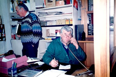
Photograph, Wally Hoersch of J&V Warren-Smith Auto, 1991
The land along the eastern side of the Union Road shops between Montrose Street and the railway line was originally owned by the Zeplin family. It was subdivided in 1914 and offered for sale as individual sites. Building did not occur until after WW1 and after the creek across Union Road had been barrelled. The photo was taken in the office of the garage which was built at 145 Union Road in 1925. It has had continuous use as a garage since then. Originally there were petrol bowsers on the footpath. The façade of the building is remarkably the same as it was in 1925 when David Denholm was the first proprietor. He remained until c1950 and was followed by Benchley Motors P/L, then Spenden Motors P/L. John and Val Warren-Smith purchased it in c1980. In 2019 their family, including Philip and Glenn Warren-Smith and 2 of Philip's sons, still operate it as J&V Warren-Smith Auto Service. The man on the phone is Walter Kurt (Wally) Hoersch. Warmly regarded and often mistakenly thought to be Philip's father, he was not a member of the family. Wally had an interesting background, not known to many. He was born in the German Templer colony of Sarona in Palestine. It had been established in Ottoman Palestine in 1871 and is now a suburb of Tel Aviv. In July 1941, 188 people from Sarona were deported to Australia on the Queen Elizabeth. Wally's family were amongst them. They were interned in Tatura in Central Victoria until 1947. Wally lived in Mont Albert North and later Templestowe; he died on 21/7/2002.The Union Road shopping strip was assessed for heritage protection by Lovell Chen in June 2011 (Surrey Hills and Canterbury Hill Estate Heritage Study: Union Road Commercial Precinct Citation). Within this report two buildings were mentioned as, unusually, still performing their original role. These were Dartnell’s Pharmacy at 376-378 Canterbury Road (contributory) and the motor garage at 145 Union Road (contributory). This is one of a number of 3 images taken in 1991 which document the interior and function of the building.A colour photo of a man sitting behind a desk in an office on the phone. There is another man standing behind him to his right.john warren-smith, val warren-smith, philip warren-smith, glenn warren-smith, walter hoersch, wally hoersch, j&v warren-smith auto, union road, businesses, garages, benchley motors p/l, spenden motors p/l,