Showing 1553 items
matching gippsland history
-
 Orbost & District Historical Society
box of documents, 1966 - 1985
These documents show the beginnings of the society with a committee in 1966 leading to the formation in 1967,These documents record the history of the Orbost & District Historical Society.A cardboard box of documents of Orbost & District Historical Society, It contains minutes, correspondence, accounts, receipt and cheque books. There are also two keys. orbost-history-documents -
 Orbost & District Historical Society
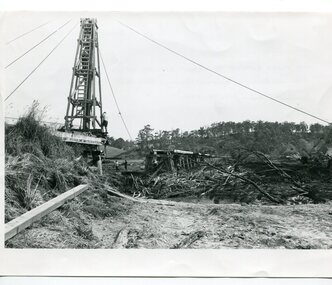
black and white photographs, 15th February 1971
The 1971 flood was the the worst flood on record. At Jarrahmond it was at least 11 metres and up to one and a half kilometres wide on the flats causing enormous damage to the flood plain. Records say that "The brown floodwater stain in Bass Strait could be seen from passing airliners." Considerable damage was done to railway infrastructure, roads and farms. More information from the APRIL, 2008 newsletter by John Phillips. (see orbosthistory.com.au) The railway line was destroyed and was not expected to be opened for a fortnight. Orbost was cut off by 50 square miles of Snowy River floodwater. These photographs are pictorial records of the 1971 floods which was a significant event in the history of Orbost. They are also associated with the East Gippsland Railway.Three black / white photographs of flood debris and flood waters near a railway line. 3102.l has a pile driver 3102.2 shows a gap in the viaduct and 3102.3 shows men with a tractor cleaning up the debris,3102.1 - on back - "1971 FLOOD REPAIRS TO ORBOST RAILWAY VIADUCT - 15th February 1971. Donated by Audrey Van Den Berg VRH 3693" 3102.2 - on back - " DAMAGE TO RAILWAY VIADUCT ACCUMULATED DEBRIS" 3102.3 - on back - "DAMAGE TO RAILWAY VIADUCT AT ORBOST. CLEAN UP BEGINS"orbost-flood-1971 orbost-viaduct-flood-damage orbost-railway -
 Orbost & District Historical Society
black and white photographs, Jude, Ray, 1915 - 1969
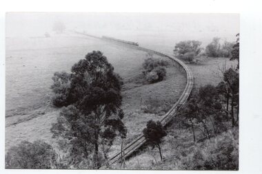
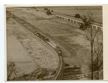
These photographs relate to the East Gippsland Railway. The Bairnsdale-Orbost railway was opened in 1916 to serve the agricultural and timber industry. Because of the decline in traffic and heavy operating costs, the line was finally closed in August, 1987. Orbost Railway Station was opened on Monday 10 April 1916 as the terminus of the Orbost railway line, and closed in 1987. The station was located on the west side of the Snowy River despite the town of Orbost being on the east side of the river, in order to save on the costs of a bridge over the river, which at the time had highly variable levels. These photographs are associated with the history of the Orbost-Bairnsdale railway line and therefore reflects the role that the rail line played in the social and economic history of Orbost.Seven black / white photographs and one postcard print.3103.1 on back - " Orbost- Snowy River flats viaduct 22-2-1964 ARHS special train Ray Jude photo" 3103.2 - on back -" Orbost Snowy River flats viaduct A.R.H.S. special train 22.2.1969" 3103.3 - on back - " A.R.H.S. special across bridge between Waygara & Nowa Nowa 22-2-1964 3103.4 - on back - " Nowa Nowa Boggy Creek Bridge A.R.H.s. Orbost tour Ray Jude photo" 3103.5 - on back - " Orbost 22-2-1969 SM office & goods shed Ray Jude photo" 3103.6 - on back - " Orbost Railway Yards - 22 February 19369 Ray Jude photo" 3103.7 - on back - " Orbost May 27 -1936 Orbost Rail Station" 3103.8 - on front - caption - Unloading Ballast Orbost line near Newmerella 1915 - J. Sullivan Colin ?orbost-railway east-gippsland-railway bairnsdale-orbost-railway -
 Orbost & District Historical Society
black and white photographs, Snowy River Mail, August 21 1987
... gippsland These photographs are from the Snowy River Mail newspaper ...These photographs are from the Snowy River Mail newspaper, September 9, 1987. Ron Hayward's family ran a shop in Rupert Street, Orbost.This item is associated with the history of the Orbost-Bairnsdale railway line and therefore reflects the role that the rail line played in the social and economic history of Orbost. The closure of the line was a significant event in Orbost's history.Five black / white photographs related to closure of the Orbost - Bairnsdale Railway Line.3104.1 - on back - "A view from Grandview, Newmerella, of the last train to leave Orbost on Friday August 21, 1987. As the afternoon sun lengthens the shadows on the Snowy River flats, the sun also sets on an era in Far East Gippsland transport as the last train crosses the viaduct." 3104,2 - 0n back - "Ron Hayward passes over the staff during the last crew changeover for the last train to run on the Orbost line. Ron Haywood (L) who 39 years and 6 months ago drove the first diesel loco to Orbost (T366T) presents the last staff to the driver, Bill Buckley, who took the last diesel out." 3104.3 - on back -" as above - 2nd paragraph only 3104.4 - on back - " Ron Hayward who took the first diesel engine from Bairnsdale to Orbost on February 21. 1957 when he was stationed at Orbosst. Last Friday he rode on the last diesel to Orbost after obtaining a special pass from V Line , he also handed over the staff for the last change at Orbost. The last driver was Bill Buckley." 3104.5 - on back - "LAST TRAIN ROLLS INTO ORBOST B/A Friday August 28 1987 For Ron Hayward the last train journey on the Orbost rail line was a sad occasion. Mr Hayward took the first diesel engine from Bairnsdale to Orbost on February 21, 1957, whe he was stationed at Orbost. Last Friday he rode on the last diesel too Orbost after obtaining a special pass from V-Line. He also handed over the staff for the last change at Orbost. The last driver was Bill Buckley. Mr Hayward was an engine driver with nhe railways and transferred to Orbost when steam engines used the line. He left the railways in in 1957 but took up a job with them again in 1968. He said also it was a privilege to have been able to ride on the last train, the occasion was a sad one,"east-gippsland-railway railway-closure hayward-ron buckley-bill orbost-bairnsdale-railway -
 Orbost & District Historical Society
black and white photographs, August 21 1987
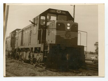
These photographs are of the final train to leave Orbost railway Station on August 21 1987 signalling the closure of the line. 3105.12 shows Locomotive T408 and on the side is written "LAST TRAIN EX ORBOST 24.8.87". These photographs are associated with the history of the Orbost-Bairnsdale railway line and therefore reflects the role that the rail line played in the social and economic history of Orbost. The closure of the line was a significant event in Orbost's history.Fifteen black / white photographs of the last train to leave Orbost Railway station.3105.1 - on back - "Last Train leaving Orbost Railway Station on Friday August 21. 1987. SRM August 26 1987 Last train from Orbost, Friday last saw the end of an era when the last freight train to pull out of Orbost Station at about 4.co pm. A symbolic wave from engineer, Bill Buckley, was the only ceremony to mark the passing of rail transport for East Gippsland." 3105.2 - on back - " Last train prepares to leave from Orbost on August 21, 1987." 3105.3 - on back - " The Orbost railhead following the departure of the last train on Friday August 21, 1987. Shows spectators who farewelled the last train." 3105.4 - on back - "From Grandview, Newmerella, shows the last train from Orbost crossing the timber Trestle (sic) viaduct across the Snowy River flats on Friday August 21, 1987" 3105.5 - on back - " A pair of Series 3 "T" Class Diesel Electric locomotives which were used to haul the final train from the Orbost Rail Head on Friday, August 21, 1987. Goods shed on right" 3105.6 - on back - " VFTY Timber Wagons at the Orbost Railway Station. 30 of these large wagons were built for the timber traffic between Orbost and Melbourne. Part of last train to leave Orbost on August 1, 1987." 3105.7 - on back - "The Fordson powered Rail Tractor which was used during shunting at the Orbost railway station, hooked up behind the second locomotive for its final journal from Orbost on Friday August 21, 1987." 3105.8 - on back - "Two Series 3 "T" Class Locomotives (Diesel Electric) were used to haul the final train from Orbost - T408 and T347, T408 was the leading locomotive. Orbost Goods Shed is on the left. Last train left on Friday August 27, 1987." 3105.9 - on back - " 3 "T" Class Diesel Electric locomotives often used in pairs to haul the timber trains out of Orbost. This locomotive was used to lead (haul) the final train from Orbost on Friday August 21, 1987" 3105.10 - on back - "The Gantry at the Orbost Railway Yards - capacity 10 tons. The last wagons before being hooked up to the locos for their last trip out of Orbost on Friday August 21, 1987" 3105.11 - on back - " Station Masters Office and Goods Shed at Orbost Railway Station. The two Series 3 "T" Class Diesel Electric locomotives waiting to haul the final train from Orbost on Friday 21 1987" otrbost-bairnsdale-railway east-gippsland-railway orbosr-railway-closure -
 Orbost & District Historical Society
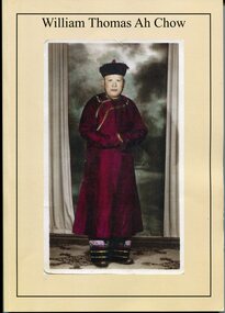
Booklet - Booklet, softcover, William Thomas Ah Chow, March 2019
... gippsland This family history book was published as a family record ...This family history book was published as a family record of the Ah Chow family. A limited number of copies were printed. Thomas William (Bill) Ah Chow was a Chinese-Australian soldier, farmer, fire lookout and legendary bushman of East Gippsland in Victoria. Many Chinese came to the Victorian gold rush in the 1850s to seek their fortune at the Omeo and Cassilis diggings. Many of the immigrants later settled and integrated into their local communities working as farm labourers, tending market gardens, making furniture, running grocery stores and cafes or practising Chinese medicine. Thomas William "Bill" Ah Chow of Bruthen, Victoria attempted to enlist early in the War but was rejected for being "not substantially of European origin". Undeterred, he reapplied and was accepted in June 1917. During his service with the 5th Battalion, he was wounded at least three times. After the War, Bill returned to Bruthen where he drove sheep, worked cattle and eventually assisted in the building of roads through the area. He became a Forestry Commission fire-spotter and built a hut called 'Moscow Villa' in 1942. He lived in the hut during the summer months and in winter, returned to his family in Ensay. Whenever there was fire danger, he rode his horse up to the fire tower on Mt Nugong and acted as look-out. Bill worked for the Forestry Commission for more than twenty years and came out of retirement to continue his duties when no suitable replacement could be found. Bill died in 1967 and is buried in Omeo. Moscow Villa still stands and is a popular camping site This is a useful reference item. As a family history it is detailed and contains useful copies of personal documents. Bill Ah Chow, along with the Ah Chow family were well known in Orbost and East Gippsland. This booklet is a testament to his life. A soft covered 97pp book with a cream cover. On the front is a coloured photograph of a Chinese man in traditional robe and hat. On the back cover is Moscow Villa. It contains information, copies of 1949 photographs, documents, hand -written letters and a will. There is an envelope attached to the inside cover containing a CD, photos and family tree.ah-chow-william-thomas family-history-ah-chow -
 Eltham District Historical Society Inc
Document - Certificate of Title, Landata, Vol. 4930 Fol. 985900, Crown Portion 15 Section 5, Parish of Nillumbik, County of Evelyn, 1925
(Cancelled) Certificate of Title originally issued for Crown Portion 15, Section 5 to Robert David Taylor, of Eltham, County of Evelyn, Farmer, 13 March 1925. It is with this title that the land allotment was subdivided into 48 lots. The title shows the issuance to Robert David Taylor with encumbrance placed upon it by immediate former owner, Hugh Patrick Keogh, a former member for Gippsland and Melbourne Real Estate Agent. Following Taylor's death in 1934 the title passes to his Executors, sons Robert David Taylor of Bible Street, Eltham and William McLelland Vance Taylor of Northcote. The property is then sold to Frank Stokes who develops the Stokes Orchard. Compulsory acquisitions by the Melbourne Metropolitan Board of Works and State Electricity Commission show provisions of easemenst for town water supply and high voltage power transmission lines. Subsequent lots are then sold off with the development of the Stokes Orchard Estate residential development in the mid to late 1970s. A History of the Development of Crown Allotment 15, Section 5, Parish of Nillumbik – Stokes Orchard Crown Allotment 15, Section 5, Parish of Nillumbik (CA15) is a square allotment of 158 acres or approximately a quarter of a square mile. It lies just beyond the eastern end of Pitt Street, south of Nyora Road to the northern end of Eucalyptus Road and extends east from Eucalyptus Road to Reynolds Road. The topography of CA15 is generally steep, sloping up to a hill near the centre of the land, the ridgeline passing through the properties along the southern side of Diosma Road. Eucalyptus Road is a straight north-south road with its northern end at the north west corner of CA15. Until the end of the 1970s this road was an un-named Government Road and was largely not open to traffic. With residential development in the 1970s the road was constructed, and the council allocated the name obviously in recognition of the predominant species of the local bushland. CA15 was purchased from the Crown by George D’Arley Boursiquot, a prominent Melbourne printer, on 28th October 1852. On November 23, 1922, former Member for Gippsland and Melbourne Real Estate Agent, Hubert Patrick Keogh purchased the allotment then sold it March 13, 1925, to local farmer, Robert David Taylor, a former Shire of Eltham Councillor (1911-1920) and Shire President (1919). Taylor had extensive land holdings stretching west towards Bible Street and Main Road. The Taylor home was situated at the top of the hill in Bible Street at present day 82 Bible Street. At the time of Taylor’s purchase in 1925, CA15 was subdivided into 48 lots that could be described as small rural properties or large residential lots. A typical lot size was one hectare or 2.5 acres. The subdivision created two roads, Nyora Road, and Diosma Road, each following an irregular alignment between Eucalyptus and Reynolds Roads. However, the lots were not sold off separately nor were the roads constructed. The land effectively remained as one parcel for many further years. Robert David Taylor died November 30, 1934, and probate was granted to his son of the same name, Robert David Taylor of Bible Street, Salesman and William McLelland Vance Taylor of 73 Emmeline Street, Northcote, Clerk, with the transfer of the land into their names on July 8, 1935. Frank Stokes worked as a qualified accountant at Kennons leather factory in Burnley, while living at 1 Thomas Street, Mitcham. He suffered from migraines and wanted to return to working the land (he had previously worked on farms and orchards since coming to Australia from England in 1926, both in WA and Vic.). He first travelled to the district by train in July 1942 to find land with the intention to establish an orchard. By chance he met Arthur Bird of Bird Orchard (bounded by Pitt Street, Eucalyptus Road, and Wattle Grove) and they got talking over their common interest. Arthur put Frank up for the night and pointed out the land, 158 acres- part of the Taylor Estate- £900, Crown Allotment 15, Section 5, Parish of Nillumbik (CA15) somewhat diagonally opposite Bird Orchard. Stokes applied through the Riverina Agency to purchase the land who in turn applied for permission from Canberra to sell as there was a new government regulation introduced during the Second World War banning land sales except for immediate production. Stokes obtained a loan on his Mitcham house of £600 @ 5% and paid £450 deposit with quarterly payments of £15 spread over 5 years. Stokes was assisted and advised by Arthur Bird who farmed the neighbouring orchard. In early 1943 Stokes took possession and would catch the train out to Eltham on Fridays after work and began building a hut on the corner of Nyora Road and the Government Road (Eucalyptus Road) for shelter and to lock up tools. He established an orchard on the central western part of the land through the centre of which ran a natural waterway (part of the present-day linear park) and was able to pay a neighbour (Hawkins) to help with clearing and fencing 25 acres, and with a horse and single furrowed plough, planted approximately 2,500 fruit trees - cherries, peaches, plums, almonds, pears, apricots and lemons as well as a few apples and oranges; a massive task. Aerial photographs from the 1940s through to the 1990s clearly show the orchard with most of the larger CA15 site remaining as natural bushland. A huge problem was hares and rabbits eating all the new buds off the tiny trees. As well as laying poison he painted the trees with a mixture of cow manure and lime, often working by moonlight. Procurement of wire and wire netting was difficult because of the war but after much effort he obtained a permit from the Agricultural Department for supplies in March 1944. In February 1945 Stokes applied for a permit to build a “packing shed” as no house building was allowed. It was to be 33 feet x 21 feet and cost £312. It was constructed mostly from second-hand materials, which were hard to obtain, especially iron for roofing. Stokes finished work at Kennons on October 31, 1945, and in March 1946 he sold the family home at Mitcham for £1,230 plus £170 for furniture. On May 15, 1946, title to the CA15 property was issued to Frank Howard Alfred Stokes, Orchardist and Gladys Ethel Stokes, Married Woman, both of Pitt Street, Eltham. The family of five then moved into the very unfinished “packing shed” at Eltham, which was a struggle to weatherproof. Eventually rooms were divided off and lined with hessian bags and whitewashed. Their income was firewood (cut and sold), selling rockery stones and cut Sweet Bursaria. (It was discovered during the 1940s that Sweet Bursaria contained the sunscreen compound Aesculin. The RAAF utilised this compound from Sweet Bursaria during WW2 for pilots and gunners.) The orchard’s first fruit sale was a half-case of Le Vanq peaches in December 1947 for the price of 8 shillings. In 1956 plans for house were drawn and Glen Iris bricks purchased (1956 Olympic Rings variant). The building of the house commenced in 1957 - 12 feet of original packing shed was removed – and was completed in 1959. Water was connected from newly built pressure storage on the property at the end of 1959 and the electricity connection for the first time at 3pm on April 29, 1960. The house remains to present day (somewhat modified) at 1 Nyora Road, home to Nyora Studio Gallery. On occasions, spare remnants of the 1956 bricks have been known to be unearthed in gardens on the estate as they were utilised by Frank Stokes to fill in rabbit holes. On May 26, 1950, a parcel of land was compulsorily acquired by the Melbourne and Metropolitan Board of Works on the hilltop to establish an easement for a high-level service reservoir to augment Eltham’s water supply. The project also included pipe tracks for the necessary water mains. The reservoir has now been superseded by higher level water tanks east of Reynolds Road and its former site is now a public reserve. On November 27, 1964, the State Electricity Commission served notice to compulsorily acquire a further parcel through the eastern part of the land for a major electricity transmission line that augmented supply from the La Trobe Valley to Melbourne. The easement was registered February 11, 1966. The easement was widened July 18, 1969 for a second transmission line to be constructed. In 1971 Melbourne Metropolitan Planning Scheme amendments adopted Nyora Road as the boundary between a residential zone to the north and a rural zone to the south. This determined the future development of the land. In the mid-1970s the Shire of Eltham divided the orchard into numerous rate-able parcel lots, the 48 lots having been established in 1925 and the subsequent rates assessment proved unsustainable for Stokes. He commenced selling lots outside the boundary of the orchard, north of Diosma and South of Nyora. However shortly later the land between Nyora and Diosma Roads and west of the electricity easement was sold and subdivided into residential lots, a housing development by Macquarie Builders and marketed as the Stokes Orchard Estate. New streets were created, and most were named after trees, although one, Stokes Place, commemorates the former owners. The development was undertaken in two stages; Stage 1 (1975) encompassing Scarlet Ash Court, Ironbark Close and Peppermint Grove bounded by Nyora and Eucalyptus roads and Stage 2 (1978) encompassing Stokes Place, Orchard Way, The Crest and The Lookout bound by Nyora and Diosma roads. The developer, Macquarie Builders went bankrupt shortly after the release of Stage 2 leaving many purchasers to fend for themselves and arrange for their own independent builders. There were also difficulties with sewerage for the land immediately south of Diosma Road and so the conventional residential lots were abandoned in favour of larger lots. The development of Orchard Way, The Crest and The Lookout did not proceed as planned and the proposed lots were incorporated into five-acre parcels instead. These included a low-density group housing development by the Graves family and the award winning Choong House (1983) with Gordon Ford developed garden immediately next door situated on the ridge of the hill nestled amongst the original bush, Eucalypt trees and Sweet Bursaria. In 1994, Nillumbik Shire Council applied Significant Environment and Significant Landscape overlays upon the properties on the south side of Diosma Road to ensure protection of this natural bush garden environment. With the arrival of the sewer along Diosma Road in the 1990s, most of these five-acre parcels have since been subdivided multiple times. The Choong house presently sits on a 2.7-acre property, which in 2022 Nillumbik Council nominated for Cultural Significance Heritage protection and is considered potentially significant at State level. The Stokes family were also associated with the Eltham Christian Church. In the 1970s this church had met in temporary premises in Eltham. Lots of the original 1925 subdivision remained south of Nyora Road and a number of these lots were utilized for the Eltham Christian School, which was established by the Eltham Christian Church in 1981. The school operated on this site until 2000. The premises are now used by The Vine Baptist Church. By the mid-1980s the whole of CA15 had been developed for residential and school purposes, except for the sections north of Diosma Road and between the transmission lines and Reynolds Road. Sewerage issues had been resolved for the section north of Diosma Road and in 1987 it was in the process of being subdivided into residential lots. The development coincided with the discovery of colonies of the rare and endangered Eltham Copper Butterfly on the site. This resulted in a community and political campaign to save the butterfly habitat. With the co-operation of the land developer the subdivision was altered to create two bushland reserves in the critical butterfly habitat areas. In the late 1980s the State Government was investigating options for establishing a metropolitan ring road link between Diamond Creek and Ringwood. The chosen route was adjacent to Reynolds Road and so this created a freeze on development of CA15 between Reynolds Road and the electricity easement. The ring road proposal was eventually abandoned, and this part of the land was subdivided into low density residential lots. Diosma Road has been discontinued at the electricity easement and the eastern part incorporated into View Mount Court with access from Reynolds Road. The whole of CA15 has now been developed for residential or associated purposes, ranging from conventional density to quite low density south of Nyora Road. Some remnants of the orchard remain, a few cherry trees on the Graves property and a lone apple tree in Stokes Place. The butterfly reserves comprise significant areas of remnant bushland. Linear reserves through the estate link with central Eltham via the Woodridge linear reserve and with Research along the electricity easement. CA15 as it exists today has a complicated history of rural use, Government acquisition, urban development, and community action. References: • “Stokes Orchard, an incomplete history”; Russell Yeoman with Doug Orford • Correspondence, Beryl Bradbury (nee Stokes) • Aerial Photographs, 1931-1991, Landata (landata.vic.gov.au) • Certificate of Title, Vol. 4930 Fol. 985900 • Plan Number LP 10859 neil webster collection, diosma road, eltham copper butterfly, eucalyptus road, ironbark close, nyora road, peppermint grove, power transmission lines, reynolds road, scarlet ash court, stokes orchard estate, stokes place, woodridge estate, frank stokes, certificate of title -
 Glen Eira Historical Society
Document - Murrumbeena State School No. 3449
This file contains a photocopy of entry for Murrumbeena Primary School from a Caulfield Conservation Study by Andrew Ward, March 1995, noted in study are site address, a description of the building’s structure, history, references and statement of significance. Also in this file is a typed history of Murrumbeena Primary School with added hand – written notations. There is not author and it is undated.murrumbeena primary school, rosstown state school, multi – purpose hall, murrumbeena state school, gippsland railway, enrolment, hobart road murrumbeena, presbyterian church hall, out of school hours., statement of significnace, carnegie state school, east kew primary school, andrew ward., victorian public works department, staff and administration, maintenance. -
 Marysville & District Historical Society
Book, Education Department of Victoria, Vision and Realisation-A Centenary History of State Education in Victoria-Volume 3, 1973
... gippsland west gippsland A centenary history of state education ...A centenary history of state education in Victoria.Red cover with the title and volume written on the spine in gold lettering. Both front and back inside covers have a photograph of 'The school at Drummond North' Photo: Geoff Mauger non-fictionA centenary history of state education in Victoria.education, state education, victoria, history, port phillip western, port phillip eastern, upper goulburn, goulburn, upper murray, east gippsland, west gippsland -
Federation University Historical Collection
Booklet, A History of the Yallourn Power Station and Briquette Factory
A history ofof the Yallourn Power Station and Briquette Factorylatrobe valley, brown coal, yallourn, power generation, morwell power station, gunai kurnai, aborigines, gippsland, bark canoe, angus mcmillan, george augustus robinson, william thomas, lake tyers, ramahyuck, hazelwood, morwell, great morwell coal mining company, electricty demand, john monash, state electricity commission, yallourn north open cut, a.r/ la gerche, yallourn power station, yallourne briquette factory, bill morrison, f. hasse, ernest bates, migration, morwell gas plant -
 Bendigo Military Museum
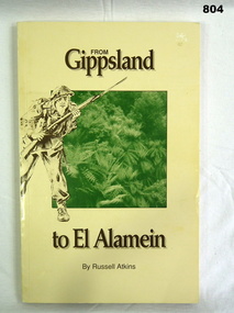
Book, James Yeates, From Gippsland to El Alamein, 1994
Soft covered paperback. Yellow cover with title, brown. Illustration on front, title on spine. Black and white illustrations. 174p, page edges cut. Bendigo and District RSL stamp on inside of front cover.books, military history -
 Phillip Island and District Historical Society Inc.
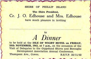
Documents, Shire of Phillip Island et al, 1940's
Documents and Photograph donated by the Woodhead family. Dorothy Edhouse was the only child of James & Frances Hill, who were Sylvia Woodhead's grandparents. "James Hill (Jimmy) came to Phillip Island in 1920 and purchased the Hotel, known as Woods Family Hotel. (Later, the Phillip Island Hotel in Walpole Street, now demolished). A milestone occurred whilst in his capable hands, when he installed an electric light plant, (32 volt), the first on the Island. He also made hundreds of cement bricks, when he built his own home. Later he purchased a building in Thompson Avenue, where he established a Billiard Saloon, with a small shop attached. He died in 1937, aged 68. His only child Dorothy Edhouse, is now 95 and has made arrangements to have her ashes added to her fathers' grave." This was added to the photograph of James Hill and Frances Edith Hill - not sure what date it was compiled by Richard Woodhead. Frances died in 1960. The write up was take from "Garden of Memories" by Edith Jeffrey. Four documents/photograph relating to Cr J O Edhouse and his wife Mrs Dorothy Edhouse. Also came with accompanying letter from Sylvia Woodhead. 361-01: An Invitation to a Dinner at the Isle of Wight Hotel - 26/11/1943 - on the occassion of the visit of Delegates to the Gippsland Shires and Boroughs Development Association Annual Conference. 361-03: Identity Card for Dorothy Symes Edhouse. 361-04: Circular from the Liquid Fuel Control Board dated 21st February 1942. 361-05: Photograph of James & Frances Edith Hill. A note saying that James (fondly called Jimmy) came to Phillip Island in 1920 and purchased a hotel - see history below. james & frances edith hill, shire of phillip island dinner invitation, identity card, cr j o edhouse, mrs edhouse, sylvia woodhead, documents -
Phillip Island and District Historical Society Inc.
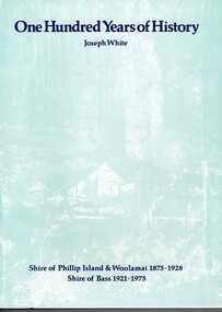
Book, WHITE, Joseph, One hundred years of history, 1974
Stamped 'Phillip Island & District Historical Society'. 'Donated by Shire of Phillip Is.'bass, victoria, shire, history, phillip island, woolamai -
 Phillip Island and District Historical Society Inc.
Book, WHITE, Joseph, One hundred years of history by Joseph White, 1974
Written for the centenary of Shire of Phillip Island and WoolamaiHistoricalHard cover book with dust cover in pale blue. Black and white with photos.Stamped 'Phillip Island & District Historical Society'. Signed by ? 11 councillors?phillip island, victoria, history, woolamai, shire, bass, joseph white, local government, phillip island shire councillors, grantville -
 Greensborough Historical Society
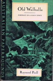
Book, Raymond Paull, Old Walhalla: portrait of a gold town, 1963
... Plenty Lower Plenty melbourne walhalla mining towns gippsland ...The history of Walhalla from its early gold mining days.147 p., black and white illustrationsnon-fictionThe history of Walhalla from its early gold mining days.walhalla, mining towns, gippsland, gold mining -
 Mission to Seafarers Victoria
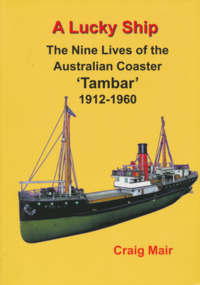
Book, Nautical Association of Australia Inc, A Lucky Ship – Nine Lives of Australian Coaster Tambar 1912-1960, 2013
This high-quality book is the extraordinary story of an ordinary little ship that had a long and eventful life. Perhaps few Australian coasters have had a more interesting and varied history. Built in Scotland in 1912 for the North Coast Steam Navigation Company, Tambar worked as a lifeline to isolated river and island communities, first in New South Wales, then for the Tasmanian Government and Holymans in Bass Strait (King Island) and as the last steamer serving the Gippsland Lakes. In between she even spent a few years in Papua New Guinea. When World War II broke out, Tambar was commissioned into the RAN as an auxiliary minesweeper, but after the terrible Darwin air raid in 1942 became the first vessel of the newly formed Salvage Board, later assisting in the search for survivors of the Battle of the Coral Sea. Returning to Bass Strait in 1944 for a few more years, she then spent the 1950s on standby as a salvage vessel in Melbourne, working on Merilyn, Terawhiti, E.J. Fairnie, and River Burnett. Craig Mair grew up in Grangemouth, Scotland where Tambar was built, and became interested after inheriting a builder's model from his father. He has consulted thousands of records, including the ship's logs, tracked down witnesses, and assembled over 100 photographs and maps to give a unique insight into Tambar's story, and coastal Australia in the middle decades of the twentieth century, before roads took over the transport task. Besides many colourful stories of shipwrecks and strandings, strange cargoes, salty characters, exotic places, wartime air raids, and salvage jobs, the book includes a definitive account of the worst Second World War 'friendly fire' incident in Australian waters in Moreton Bay in 1942.250 pages, Appendices, Bibliography and Indices, extensively illustratednon-fictionThis high-quality book is the extraordinary story of an ordinary little ship that had a long and eventful life. Perhaps few Australian coasters have had a more interesting and varied history. Built in Scotland in 1912 for the North Coast Steam Navigation Company, Tambar worked as a lifeline to isolated river and island communities, first in New South Wales, then for the Tasmanian Government and Holymans in Bass Strait (King Island) and as the last steamer serving the Gippsland Lakes. In between she even spent a few years in Papua New Guinea. When World War II broke out, Tambar was commissioned into the RAN as an auxiliary minesweeper, but after the terrible Darwin air raid in 1942 became the first vessel of the newly formed Salvage Board, later assisting in the search for survivors of the Battle of the Coral Sea. Returning to Bass Strait in 1944 for a few more years, she then spent the 1950s on standby as a salvage vessel in Melbourne, working on Merilyn, Terawhiti, E.J. Fairnie, and River Burnett. Craig Mair grew up in Grangemouth, Scotland where Tambar was built, and became interested after inheriting a builder's model from his father. He has consulted thousands of records, including the ship's logs, tracked down witnesses, and assembled over 100 photographs and maps to give a unique insight into Tambar's story, and coastal Australia in the middle decades of the twentieth century, before roads took over the transport task. Besides many colourful stories of shipwrecks and strandings, strange cargoes, salty characters, exotic places, wartime air raids, and salvage jobs, the book includes a definitive account of the worst Second World War 'friendly fire' incident in Australian waters in Moreton Bay in 1942.naa, australian national line, interest group, moreton bay, tambar, coaster, ships -
Glenelg Shire Council Cultural Collection
Photograph - Photograph Album - Photos of Victoria, c. 1948
Photograph album, green covers, contains black and white photos of Canberra, Gippsland, Albury, Hume Weir, Gundagai, and the Grampians. -
4th/19th Prince of Wales's Light Horse Regiment Unit History Room
Regimental Scrap Book: 1990-1999, 2009
Archival quality A3 loose leaf slip case containing memorabilia documents, cuttings and photos about the Regiment for the period 1990-1999. Contents include:Training, Ceremonial, social activities. Hansard 18 Oct 1990 re future of the Regiment. Threats to the Regiment. Chief of General Staff Commendation to A Squadron 4/19 PWLH for assistance with flood emergency in Gippsland April 1990. Meritorious Unit Commendation to Prince of Wales Light Horse Troop while attached to 173 US Airborne Brigade, South Vietnam 1965/66. Freedom of City of Melbourne May 1992. 50th Birthday of Regiment. Closure of Traralgon Depot 1998.ceremonial, training, vietnam war, history 4 19 prince of wales s light horse, freedom of city melbourne, freedom of city traralgon, traralgon army depot, commendations, gippsland floods -
4th/19th Prince of Wales's Light Horse Regiment Unit History Room
Souvenir Programme, South Gippsland Publishing Co Pty Ltd, 100 Years Centenary Toora 1888-1988, 1988
A souvenir programme for the township of Toora centenary on the week end 11- 14 March 1988. The Band of the 4th/19th PWLH's tasks were to hold recitals, provide music at various locations , lead a street procession and 'Beat the Retreat' at the RSL.band, foster, centenary -
4th/19th Prince of Wales's Light Horse Regiment Unit History Room
Order of Ceremony, The Royal Australian Amored (sic) Corps the Keeffe Family & Eoghan McDonald Celebrates (sic) the Unveiling of a Commemorative Plaque 16 November 2014, 2014
The 13th Australian Armoured Regiment was a Gippsland militia unit that had been called up for full time duty in December 1941 as a traditional light horse regiment. The early months of 1942 had seen the regiment lose its horses, a conversion to a motor regiment and finally to an armoured regiment in May. During this period there were considerable changes in personnel, however the regiment maintained its strong links to Gippsland and its former identity. Between May and November 1942, individual soldiers had become proficient in their trade training and the regiment changed its focus to troop and squadron activities. On 16 November 1942, the unit was located at the Puckapunyal Army Camp. C Squadron's training program involved a night driving exercise where a column of armoured and B vehicles would depart camp at 0245 hours and proceed to a site to the East of Seymour and set up a bivouac between Whiteheads Creek and Highlands Road. Numerous army camps surrounded the Seymour area; and much of the surrounding farm land had been acquired for military purposes. By November 1942 exercises such as C Squadron's were commonplace and had been repeated on numerous occasions since 1939. At 0400 hrs, C Squadron's vehicles reached O'Sullivan's Paddock on the Kobyboyn Road; prior to reaching the Old Telegraph Road the column turned to the North towards a known crossing point on Whiteheads Creek. The column consisted of seven M3 Medium Tanks and four Universal Carriers. In the case of Corporal McLeod's vehicle, there were seven crewmen rather than the usual five man crew. On arrival at the creek crossing, Captain C.M.I. 'Sandy' Pearson dismounted and with the assistance of Sergeant R.J. Ball began to guide individual tanks across the creek. Four tanks had crossed the creek without difficulty when Corporal McLeod's tank, ARN 24652, began its descent. Captain Pearson stated at the Coroner's Inquiry in December 1942, "Whilst climbing out of the ford the vehicle swerved to the left, apparently striking the tree. It was not the portion of the tank (front) that struck the tree. The tank straightened and appeared to be well under control, suddenly the bank on the left collapsed to the extent of 3ft by 12ft by15ft long causing the vehicle to slide into the creek and turn upside down." Captain Pearson and Sergeant Ball were faced with a nightmarish situation: The Grant had come to rest upside down in soft mud, six crew members were unaccounted for, escape hatches could not be opened and the weight of the tank was settling deeper into the water and mud. Compounding the problem was that the location of the tank did not allow for the other tanks to safely conduct a recovery. It was truly the darkest night.Single A4 card. folded, Contains an account of the raising of 13 Armoured Regiment in December 1941and a tank accident during a night creek crossing in which six crewmen were killed, and, Order of Ceremony for plaque unveiling, Guest of Honour LtCol Stuart Cree CO/CI School of Armour13 armored regiment, tank accident, puckapunyal -
4th/19th Prince of Wales's Light Horse Regiment Unit History Room
Photograph, T Humphrey & Co, Pre World War 1
B&W photo mounted on cardboard. Group photo of 56 Officers and Sergeants of Victorian Light Horse Regiments. Badges identified - 10th (Gippsland), 8th (Indi), 7th (VMR) 11thy (Corangamite), 9th Yarrowee. Location - possibly (?) Flinders Street Extensionlight horse, group photograph -
 Raymond Island Historical Society
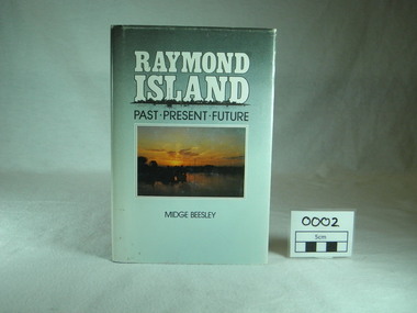
Book, Midge Beesley, Raymond Island:past present future, 1986
... Raymond Island Historical Society Paynesville gippsland ...Local history of Raymond Island. Includes stories of Island identities, maps, photographsLocal significance Out of print publicationMonograph publication 291 pages Hardback Loose cover Maps Sunset picture of lake from Raymond Island on front cover Photographs of people, buildings, Raymond Island ferries, boats. Contents: Raymond Island early settlers, indigenous history, Island identities, Raymond Island State School, a'Beckett Park, Raymond Island Ferry, The Presbyterian Church, raymond Island Advancement League park, gippsland lakes, raymond island, raymond island state school, a beckett, raymond island ferry, early, settlers, raymond island advancement league -
Raymond Island Historical Society
Oral History transcript, Pat Wilson, December 2010
Pat Wilson of the Raymond Island History Group interviewed Iris Langley for a display of memorabilia of the musical history of Raymond Island. Iris Langley was a singer in a number of bands from the 1960s to present day. She holidayed on Raymond Island in the 1970s and currently lives on the Island.Local significance. Biographical information on a local musician.Transcript of interview conducted by Pat Wilson on the musical career of Iris Langley. Contains details of the bands she sang with The Silhouettes, The Boomerangs, This Time Around. Details her marriage to Ron Langley.iris langley, pat wilson, raymond island history group, raymond island music, the silhouettes, the boomerangs, this time around, ron langley -
Raymond Island Historical Society
Book, Memories of My Early Life, late 2010
Biography of Vivienne Pearl Sullivan growing up on Raymond Island in Victoria 1935-1950History of Raymond Island and local residentsSoftcover Book - white Sepia tone Image of Raymond Island on cover. A4 portrait size 53 pagesMemories of My Early Life By Vivienne Pearl Sullivan (nee Smith)raymond island, vivienne pearl smith, vivienne pearl sullivan, 1935 50 -
 Warrnambool and District Historical Society Inc.
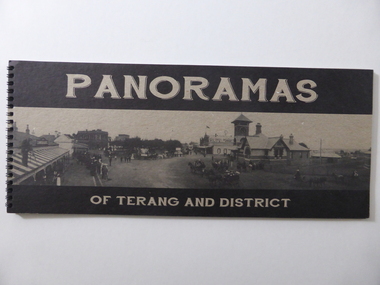
Book, Panoramas of Terang and District, Early 21st century
This is a book containing early 20th century photographs of the town of Terang in the Western District of Victoria. Most of the photographs were taken by Robert Frederick Scott (1877-1953). He was born in Koroit and came to Terang in his early years. He took up coach building and in 1906 he moved to Cobden where he continued coach building with W.J. Silvester. He was regarded at the time as a clever mechanical engineer and was a pioneer in the motor garage business. In the 1930s he was a representative for the Melbourne firm of A.H. McDonald & Co. in the machinery business. He installed milking machines in the Western District and Gippsland. His hobby was photography and he took many photographs in the Western District and supplied photographs to the Victorian Railways for inclusion in the train carriages. This book is of considerable interest as a record of the town of Terang in the early 20th century. The photographs are of high quality and the book will be useful to researchers.This is a soft cover book of 52 pages. It contains black and white photographs of early 20th century Terang and district. The photographs are set in a grey-coloured frame and on the page opposite the photograph is a description of the photograph. The cover is made of lightweight cardboard and the front cover has the title of the book and a black and white photograph of the town of Terang. The book is bound with plastic spirals.history of terang, robert frederick scott, history of western district, warrnambool history -
 Orbost & District Historical Society
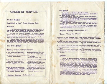
program, 1936
This service was held on January 28, 1936 at the Mechanics' Institute, Orbost. Born in 1865, George V was the second eldest son of Edward VII and Alexandra 1865. He first visited Australia with his elder brother Prince Albert as midshipmen aboard the HMS Bacchante in 1880. He was King of the United Kingdom and the British Dominions, and Emperor of India, from 6 May 1910 until his death in 1936. The Shire of Orbost was a local government area about 380 kilometres east of Melbourne. The shire covered an area of 9,347 square kilometres and existed from 1892 until 1994. Originally, Orbost was part of the Bairnsdale Road District which was created on 30 April 1867. Splitting away as part of the Shire of Tambo in 1882, Orbost was first incorporated as a shire in its own right as the Shire of Croajingolong on 30 May 1892. It received its present name on 17 February 1893. On 3 January 1913 part of its western riding was annexed to Tambo as its Cunninghame Riding. On 2 December 1994, the Shire was abolished, and merged with City and Shire of Bairnsdale, Shire of Tambo, most of the Shire of Omeo and the Boole Boole Peninsula from Shire of Rosedale into the Shire of East Gippsland.This item reflects the significance of monarchy for Australia and the constitutional history of Australia.The item reflects the interest in the royal family to Australians at this time as well as the general feeling of respect and admiration felt by the rural communities towards the British Royal Family..A folding single sheet, white paper program with a dark purple print. It is a program for the Orbost Shire Council memorial service for the death of King George V. On the front is "Shire of Orbost Memorial Service for his late Majesty King George V". Details of the time and venue are below. This print is inside a rectangular border. On the back of the program are the words of the national anthem, Kipling's "Recessional" and a prayer. Inside is the order of the service.royalty george-v-death-memorial orbost-shire-council -
 Orbost & District Historical Society
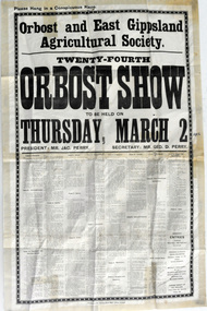
advertisement, 1916
This poster would heve been handed out to businesses for display. Produced by the Orbost and east Gippsland Agricultural Society, it was for the twenty-fourth Orbost Show. It was endorsed by the president, Mr Jac. Perry and the secretary, Mr Geo. D. Perry. The first meeting to form an Agricultural society in Orbost was convened by the then Orbost Progress Association and held in the Mechanics Hall on Saturday, 10th October 1891. Its first show was held on 3rd March 1904...on a site alongside the Bonang Road where the present Golf Club stands. It is currently held at the Recreation Reserve at Newmerella. Ref: In Times Gone By-Deborah HallThis item is associated with the Orbost Agricultural Society 's Annual Show which has been a major event in Orbost for over a century. Agricultural shows are an important part of cultural life in small country towns and the Orbost Show is an integral part of Orbost 's agricultural history.A large white paper advertisement / poster with black print. For the Orbost Show, it gives details of dates, exhibits and rules.orbost-agricultural-show event-orbost -
 Orbost & District Historical Society
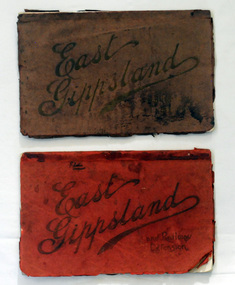
magazines, Atlas Press Pty Ltd, East Gippsland & Railway Extension, 10 September 1908
Orbost and East Gippsland Railway League had proposed a railway extension through East Gippsland in 1908, which aimed to develop an isolated part of the country. At the time, construction of a railway could be considered a beneficial investment for the country as it could increase the population in the region. The proposed railway length in 1908 was about 140 miles and the cost was estimated £800,000. The line was proposed to proceed from Bairnsdale by way of the Lower Nicholson to Bruthen. “After crossing the Tambo River, it would be carried to near Nowa Nowa; the head of Lake Tyers, forward to Orbost. From Orbost it would proceed in a north-easterly way to the New South Wales border. There were different suggested routes between Orbost and the New South Wales border, the first was through Bendoc, another by the Cann River and another which is located between these two. This item is associated with the history of the Orbost-Bairnsdale railway line and therefore reflects the role that the rail line played in the social and economic history of Orbost. The Bairnsdale-Orbost railway was opened in 1916 to serve the agricultural and timber industry. Because of the decline in traffic and heavy operating costs, the line was finally closed in August, 1987. Two small magazines showing the railway extension through East Gippsland. 678.1 has a dark maroon cover with gold print writing. It contains b/w photographs. 678.2 has a red cover with black print writing. Both are bound. 678.1 - inside front cover - M. Beattie ???????? Newmerella 678.2 - inside front cover - Gordon Fisher Orbosteast-gippsland-railway-league railway -
 Orbost & District Historical Society
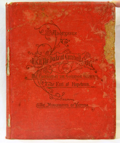
book, McCarron, Bird & Co, Addresses to H.R.H Duke of Cornwall and York, 1901
This book was published by the Municipal Association of Victoria to commemorate the inauguration of the Commonwealth of Australia in 1901. The addresses were made on the occasion of the Duke & Duchess of Cornwall & York's visit to Melbourne in May 1901. They were in the city for the opening of Federal Parliament which took place at the Exhibition Building in Carlton Gardens on 9 May 1901. .This item is associated with the history of the Federation of Australia and is a useful research tool.Hard-covered book, red cloth, with gold impressed lettering, containing 118 pages of illustrated copies of addresses to HRH Duke of Cornwall & York and His Excellency, Earl Hopetoun, the Governor General from the Shires of Victoria (includes Orbost). The addresses are surrounded by elaborate borders containing native flowers, particularly wattle. There are alsos cenes of rural Victoria. Incised on front cover - Addresses to H.R.H. Duke of Cornwall & York and his Excellency the Gov. General, the Earl of Hopetoun from the Municipalities of Victoria.federation duke-of-cornwall speeches-addresses -
 Orbost & District Historical Society
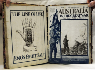
book, Cassell and Company Limited, Australia in the Great War, 1918
This is a book of photographs published by Cassell & Co. by arrangement with the Government of the Commonwealth. The profits from sales were devoted to the Australian Soldiers' Repatriation Fund. This item is a useful research tool on the history of World War 1.A 192 pp magazine publication in eight parts. It is titled "Australia in the Great War - The Story Told in Pictures". It has a mottled purple cover with purple binding.