Showing 1498 items
matching land use
-
 Eltham District Historical Society Inc
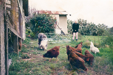
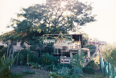
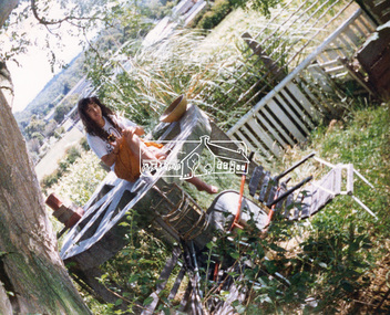
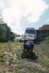
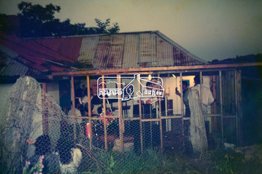
Photograph, Hans Gregory, Original 1860s William West house, Fabbro's Farm, Falkiner Street, Eltham, c.1990
Photos taken by Hans Gregory who along with partner Pauline Steele, rented the original old 1860s William West Cottage situated behind the Fabbro family home. Hans was employed as a Youth officer with the Shire of Eltham at the time and was the last tennant on the property. The property was sold and in 1995 was developed for residential housing as the Riverview Park estate. Guido Quarto Fabbro was born 21 August 1891 at Treppo Grande in the far northeast of Italy, the son of Giacomo Fabbro and Anna Geruzzi. Regina Moretti was born 6 March 1893 at Treppo Grande, Italy, the daughter of Giovanni Battista Moretti and Maria Teresa Coletti. Guido and Regina married about 1917 and they had two sons, Giacomo (John c.1918) and Maurie (c.1920). In 1925 Guido Fabbro departed his homeland from Genoa, arriving in Fremantle, Western Australia in June, travelling 3rd class aboard the ship, Caprera. Regina and their two boys followed a year later along with other family members arriving in Fremantle from Genoa 4 July 1926 aboard the Moncalieri. The Fabbros arrived in Eltham in 1933 and purchased a block of land from William West on the western side of Falkiner Street, extending to Ely and Porter Streets which had formerly been part of the West family orchard and dairy farm. As there was no fencing dividing the two properties, West served notice on Guido in December 1934 to bear half of the cost of £6. When payment was not forthcoming, West sued Guido in the Eltham Court in January 1935. Guido failed to appear and was not represented, and costs were ordered in West’s favour. Guido and Regina built a large Italianesque house on their property. The original 1860s cottage was relocated to the back of the block and was rented out (once to Alistair and Margot Knox). Guido also purchased land extending to the Diamond Creek on the eastern side of Falkiner Street and on the eastern side of Bell Street (opposite Eltham High School). The riparian soil was suitable for market gardening: Guido grew mainly tomatoes, but also pumpkins, cauliflowers, cabbages, peas, beans, lettuce, beetroot and zucchinis. Even the land surrounding the house was used. The produce was carted to Melbourne overnight for sale at the market. Guido died in 1970 and is buried in Eltham cemetery. Regina died 1986. She and their son John Patrick (Giacomo) Fabbro who died in 1984 are also buried at Eltham Cemetery. Guido’s son Maurie continued in his father’s footsteps until 2007, principally growing artichokes in later years. He died in 2009. The land on the eastern side of Falkiner Street now forms part of a Council reserve called “Barak Bushland”, the land on the western side having been sold off for residential subdivision. The Bell Street land is now public open space managed by Nillumbik Shire Council and called “Fabbro Fields”. There have been recent proposals to develop the site for sporting purposes or as a dog park or community garden. Provides an insight into early settler's farmhouses and farming property of the Eltham district.guido quarto fabbro, regina fabbro (nee moretti), william west, maurie fabbro, fabbro's farm, hans gregory, west family orchard, west dairy farm -
 Eltham District Historical Society Inc
Photograph, Fay Bridge, Ancient Eel trap on the Yarra River at Laughing Waters, Eltham - pre-dating European settlement, 16 May 2015
Laughing Waters is the name for a stretch of the Yarra Valley Parklands consisting of river flats and hilly riparian bushland. With Birrarung (Yarra River) flowing through, Laughing Waters has been an important gathering place for thousands of years. For the Wurundjeri, ‘Garambi Baan’ (the name for Laughing Waters in Woi wurrung) is an important site for growing and harvesting food. Significantly, Wurundjeri iuk (eel) traps remain at Garambi Baan to this day. The Wurundjeri Woi Wurrung People take their name from the Woi wurrung language word ‘wurun’ meaning the Manna Gum (Eucalyptus viminalis) which is common along ‘Birrarung’ (Yarra River), and ‘djeri’, the grub which is found in or near the tree. Wurundjeri are the ‘Manna Gum People’ and their Ancestors have lived on this land for millennia. The site on the Yarra River near the former Morrison property Killeavey was given a language name in 2015 at the instigation of Wurundjeri Elder, Dave Wandin. Garambi Baan means “laughing waters” in the traditional language, Woi wurrung. The site at Warrandyte was rediscovered by Campbell Beardsell OAM in 2007 and is one of only a few known remaining iuk (eel) traps on Country once found the length of the Birrarung (Yarra) and the Maribyrnong. Original Indigenous aquacultural infrastructure was dismantled, taken away from sites and used to build houses, fords and roads by Europeans. The difficult and restricted access to this site is thought to be one of the reasons for its survival. The iuk trap is located within lands managed by Parks Victoria. The Narrap team in partnership with Parks Victoria and Acacia Land Management have been improving the native vegetation with a program of woody weed removal, exclusion fencing and revegetation. Importantly, the team have restored the trap’s infrastructure and have demonstrated its effectiveness.” References: Wurundjeri Woi Wurrung Cultural Heritage Aboriginal Corporation - Laughing Waters. (2023, September 3). Retrieved from https://inplace.org.au/laughing-waters/ GARAMBI BAAN LAUGHING WATERS RESIDENCY CENTRE 2020 2024 Strategic Plan, Nillumbik Shire Council (2023, September 3). Retrieved from https://www.nillumbik.vic.gov.au/files/assets/public/minutes-and-agendas/2020/09-sep/15-sep-cm/ocm.177-20-attachment-1-laughing-waters-arts-program_1.pdffay bridge collection, 2015-05-16, eel trap, laughing waters, yarra river, wurundjeri woi wurrung, garambi baan -
 Eltham District Historical Society Inc
Photograph, Fay Bridge, Ruins beside the Diamond Creek at Wattle Glen, 13 October 2016
The newly constructed Diamond Creek Trail from Diamond Creek to Wattle Glen completed in February 2021 winds around these ruins just pass the high transmission power lines near Herberts Lane and Collard Drive From Jean Verso, Nillumbik Historical Society, 15 April 2021 William Wandless Herbert bought the surrounding 100 acres in 1852. He was a native of Northumberland and the Scottish Borders who arrived in Melbourne in 1847. The house on the top of the mound would have been built not long after he bought the land; the farm was named "Greenhills". He married Elizabeth Wilson, daughter of John Wilson who had been in Diamond Creek since about 1846. Their first child was born in 1854 so there would be some form of dwelling from about that time. They had eight children who all survived to a good age. His will describes the house as part stone and part wood and of four rooms. Nillumbik Historical Society (NHS) believe it was one of the earliest if not the earliest house, in this part of the district. The remains of the stone house foundations are on top of the mound (photos on the VHD page) and the barn walls are on the north and to the east side of the mound. NHS is not sure how much or which part of the surrounding area was covered by the barns but they were large enough to hold dances after the race meetings that were held in the late 1880's on the adjacent creek flats. It would make sense with the lay of the land that they covered some of the ground to the north and east and used for farm storage, packing sheds for their apple and pear orchards and also for supporting the Nillumbik Gold Mine the family worked to the north up the gully. The path that comes down the gully and runs into the trail goes past the mine site which was on the west side of the gully a couple of hundred metres up from the flats. Heritage Victoria link for the site - https://vhd.heritagecouncil.vic.gov.au/places/12203fay bridge collection, 2016-10-13, diamond creek, diamond creek trail, ruins, wattle glen, william wandless herbert, greenhills, elizabeth wilson -
 Eltham District Historical Society Inc
Photograph, Fay Bridge, Former Glynn's Dairy Farm, Glynns Road, North Warrandyte, 31 August 2018
Glynn’s farm Originally Section 7, Parish of Nillumbik marked Aborigine Reserve in 1866 Crown Allotment 8, Section 7, Parish of Nillumbik, County of Evelyn, Certificate of Title Volume 4095, Folio 818.835, approx. 93 acres purchased by Joseph Panton in 1881 for £1/acre and known as Panton’s Point. By 1924 owned by S.S. Sergeant and called Riverswood. Sergeant commissioned Edna Walling to design the garden. In September 1929 the property was sold at auction by Mortgagee’s sale. Described as well built, brick, tile roof, Attic Villa containing downstairs 7 good rooms, bath, scullery, inside lavatory, etc. Upstairs 2 bedrooms and sleep out. Outbuildings compromising of brick and weatherboard wash house, stables, workshop, feed room, cow bails, large G.I. Hay shed, etc In January 1931 Riverswood property was proclaimed a sanctuary for native game for the entire year. A private swing bridge crossed the river at Pound Bend was known as Pearson’s bridge after C.W.K. Pearson who bought Riverswood in the early 1930s. The bridge was swept away in the December 1934 floods. Riverswood was sold by C.W.K. Pearson at auction on 25 November 1936. Described as a beautiful farm home of 93 acres and over one mile of River Yarra frontage, modern brick residence, lovely garden, rich river flat pastures, model poultry farm. The fine brick home was destroyed on Black Friday (13 Jan.) 1939. It was still a ruin when the Evelyn Evans purchased Waikowhane above Riverswood in 1940. The Glynn family purchased the Riverswood property in 1941 from Robert and Emily Hannon. Their son Kenneth Patrick Glynn inherited the property and he set about clearing the land during WW2 selling wood. Prior to marriage, Kenneth was living alone on the farm in a house he had built from whatever was available. He used the bluestone foundations from the original fine brick home. He met and married Honora Elizabeth Drew in early 1945 and their daughter Anna grew up on the farm. It was compulsorily acquired by the Board of Works in 1976 who then rented the house out in the 1980s. The property was transferred to Melbourne Parks and Waterways in 1996. Waikowhane was a pretty timber house built on top of the hill on 50 acres above Riverswood by retired nurse Jessie MacBeth. (This would be at the intersection of Glynns Road and Overbank Road where the big water tank is now situated on what was once James Orford’s property.) It was also destroyed Black Friday and she rebuilt it from the plans living in a caravan on site supervising the build. It was almost complete when she died May 1939. The property was bought by Evelyn Evans (a city girl) and her estranged husband in 1940. She had two sons, one only 9 months old at the time. It was a timber house with no power or water connected. The Ewen Cameron family bought Waikowhane in 1957. They had to evacuate when the 1961 bushfires swept through. The house was saved by Matcham Skipper. It was demolished by Melbourne Water in the 1990s when they acquired it.fay bridge collection, 2018-08-31, glynn's, glynn's dairy farm, glynns road, north warrandyte, parks victoria, ruins, riverswood, kenneth patrick glynn -
 Eltham District Historical Society Inc
Photograph, Fay Bridge, Remains of apple orchard near the Diamond Creek, Wattle Glen, 11 October 2018
The newly constructed Diamond Creek Trail from Diamond Creek to Wattle Glen completed in February 2021 winds past these apple trees that possibly lined the entrance to the Greenhills property From Jean Verso, Nillumbik Historical Society, 15 April 2021 William Wandless Herbert bought the surrounding 100 acres in 1852. He was a native of Northumberland and the Scottish Borders who arrived in Melbourne in 1847. The house on the top of the mound would have been built not long after he bought the land; the farm was named "Greenhills". He married Elizabeth Wilson, daughter of John Wilson who had been in Diamond Creek since about 1846. Their first child was born in 1854 so there would be some form of dwelling from about that time. They had eight children who all survived to a good age. His will describes the house as part stone and part wood and of four rooms. Nillumbik Historical Society (NHS) believe it was one of the earliest if not the earliest house, in this part of the district. The remains of the stone house foundations are on top of the mound (photos on the VHD page) and the barn walls are on the north and to the east side of the mound. NHS is not sure how much or which part of the surrounding area was covered by the barns but they were large enough to hold dances after the race meetings that were held in the late 1880's on the adjacent creek flats. It would make sense with the lay of the land that they covered some of the ground to the north and east and used for farm storage, packing sheds for their apple and pear orchards and also for supporting the Nillumbik Gold Mine the family worked to the north up the gully. The path that comes down the gully and runs into the trail goes past the mine site which was on the west side of the gully a couple of hundred metres up from the flats. Heritage Victoria link for the site - https://vhd.heritagecouncil.vic.gov.au/places/12203fay bridge collection, 2018-10-11, diamond creek, diamond creek trail, elizabeth wilson, greenhills, wattle glen, william wandless herbert, apple trees -
 Eltham District Historical Society Inc
Photograph, Peter Pidgeon, White Cloud Cottage, 701 Main Road, Eltham, 2 Aug. 2022
Jarrold Cottage built c.1853, also known as 'White Cloud", located at 701 Main Road, Eltham, opposite Dalton Street. The house remains intact and is listed on the Victorian Heritage Database and considered historically significant to the Shire of Nillumbik. The cottage was originally located closer to the Diamond Creek but was subject to flooding. It was dragged by horse to the present site shown, which was chosen for the higher ground that had been created as a result of land fill being deposited here from the quarry further around the bend on Main Road (site of present-day Eltham Primary School carpark) where the stone had been quarried for building the State School in Dalton Street. It had previously been rented for use as a Police Station / residence prior to the building of the permanent police house and station at the corner of Maria and Brougham streets in 1859. The cottage was purchased by Lena Skipper after the death of Thekla Jarrold in 1943 and remains in the family to present day (2022). Comparison photo: SEPP_0749 Part of a presentation by Peter Pidgeon to the Society, 13 August 2022 showcasing a series of photographs taken by John Henry Clark over the period 1895 to 1930. John Henry Clark was the youngest of three boys born to William Henry Clark (1823-1877) and Maria White (1843-1914). He and his brothers, William Charles Clark (1872-1945), Clement Kent Clark (1874-1912) operated a photography business (Clark Bros.) from 25 Thomas Street, Windsor near Prahran during the period c.1894 to 1914. Following death of Clement in September 1912 and their mother in 1914, the Clark Bros business appears to have dissolved, the premises demolished, and a new house was under construction in 1915. John set up business independently in 1914 operating out of 29 Moor Street, Fitzroy where he is registered in the 1914 and 1915 Electoral Rolls. By 1916 John had relocated to Eltham where he continued his practice as a photographer and took many of the early images around the district of Little Eltham. Around 1930 John changed professions and opened a small cobbler's shop in 1931 near the pond opposite Dalton Street adjacent to the Jarrold family cottage. He never married and continued his profession as a bootmaker from this little shop, maintaining a close relationship with Mrs Jarrold for the rest of their lives. His bootmaker shop remains today beside the Whitecloud cottage and is one of only three remaining shops in the area from the early 20th century.Comparative photo taken 2022 with one taken from same location over 100 years earlier by noted local photographer J.H. ClarkBorn Digitaleltham, j.h. clark photo (2022), dalton street, main road, bootmaker's shop, jarrold cottage, white cloud cottage, avenue of honour -
 Eltham District Historical Society Inc
Photograph, Peter Pidgeon, White Cloud Cottage, 701 Main Road, Eltham, 2 Aug. 2022
Jarrold Cottage built c.1853, also known as 'White Cloud", located at 701 Main Road, Eltham, opposite Dalton Street. The house remains intact and is listed on the Victorian Heritage Database and considered historically significant to the Shire of Nillumbik. The cottage was originally located closer to the Diamond Creek but was subject to flooding. It was dragged by horse to the present site shown, which was chosen for the higher ground that had been created as a result of land fill being deposited here from the quarry further around the bend on Main Road (site of present-day Eltham Primary School carpark) where the stone had been quarried for building the State School in Dalton Street. It had previously been rented for use as a Police Station / residence prior to the building of the permanent police house and station at the corner of Maria and Brougham streets in 1859. The cottage was purchased by Lena Skipper after the death of Thekla Jarrold in 1943 and remains in the family to present day (2022). Part of a presentation by Peter Pidgeon to the Society, 13 August 2022 showcasing a series of photographs taken by John Henry Clark over the period 1895 to 1930.Born Digitaleltham, dalton street, main road, bootmaker's shop, jarrold cottage, white cloud cottage -
 Eltham District Historical Society Inc
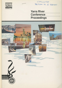
Book, Melbourne Metropolitan Board of Works, Yarra River Conference Proceedings, 1991
... , commerce and land use. Conference delegates included ...Conference staged by the Board of Works to present a range of papers examining the river's environment, recreational uses, natural resources, development, commerce and land use. Conference delegates included representatives from Eltham Shire Council and was held in April 1991. Session 1 Heritage and Environment: Flora and fauna / Paul Gullan. -- Geology and topography / Brian Finlayson. -- Aboriginal culture / Margaret Gardiner. Session 2 History. Session 3: Management plans and policies : overview of responsibilities / Dr Colin Leigh. --Role of the media / Peter Cole-Adams. -- Urban development / Paul Jerome. -- Port of Melbourne area / Leigh McKay. -- Recreation / Ken Marriott. Session 4: Perspectives - the current view. Session 5: Issues, challenges, potential solutions.non-fictionConference staged by the Board of Works to present a range of papers examining the river's environment, recreational uses, natural resources, development, commerce and land use. Conference delegates included representatives from Eltham Shire Council and was held in April 1991. Session 1 Heritage and Environment: Flora and fauna / Paul Gullan. -- Geology and topography / Brian Finlayson. -- Aboriginal culture / Margaret Gardiner. Session 2 History. Session 3: Management plans and policies : overview of responsibilities / Dr Colin Leigh. --Role of the media / Peter Cole-Adams. -- Urban development / Paul Jerome. -- Port of Melbourne area / Leigh McKay. -- Recreation / Ken Marriott. Session 4: Perspectives - the current view. Session 5: Issues, challenges, potential solutions.yarra river, melbourne -
 Eltham District Historical Society Inc
Document - Property Binder, 895 Main Road, Eltham
Folder: 895 Main Road, Eltham Contents Listing 1. Certificate of Title; Vol. 8424, Fol. 334, 5 February 1963 2. Certificate of Title; Lot 2, Plan of Subdivision No. 63242, Parish of Nillumbik, Vol. 8479, Fol. 283, 18 May 1964 (Eltham War Memorial Trust) 3. Newspaper article: Extensions to shire offices will benefit all, by Fab Calafuri, Diamond Valley News, Tuesday, July 8, 1986, p6 [Reverse side, p5, Residents rally to save dam by Helen Gillman about Peck’s Dam in Napier Street, Montmorency] 4. Office memo: Temporary Shutdown of Water Supply Shire Offices – Tuesday 9 March 1993; Anthony Guzzo, 5 March 1993 – Melbourne Water advice due to works on new library 5. Plan of Old Municipal Offices, date and creator unknown 6. Newspaper clipping: Move to convert shire office for police use, by Jodie Haythorne, Diamond Valley News, May 1995 7. Newspaper clipping: Sale of Eltham office / Removal of Question time; Nillumbik Happenings, Mountain Views, 15 May 1995 8. Newspaper clipping: Bid for TAFE campus, Mountain Views, 25 September 1995, p8 9. Newspaper clipping: Will the former Shire of Eltham offices become a TAFE college?, The Advertiser, circa September 1995 [Reverse side; Jezza! Photo of football legend Alex Jesaulenko at Watsonia RSL also Advertisement: Maternal and Child Health Centre Timetable] 10. Newspaper clipping: Eltham may get TAFE campus in shire offices, by Fiona Kaegi and Natalie Town, and Nillumbik set for rate cuts, Diamond Valley News, circa September 1995 [Reverse side; Art for hope – article about artist Damien Curtain at Hurstbridge Primary School] 11. Newspaper clipping: More talks on TAFE, The Advertiser, Tuesday, October 17, 1995, p3 – includes photos of Nillumbik Chief Commissioner Don Cordell, Box Hill College of TAFE Executive Director Andrew Jackson and Niillumbik CEO Barry Rochford; Eltham MP Wayne Phillips with Eltham Chamber of Commerce President Norm Williams and Rotary Club of Eltham President Peter Bishop; Eltham College principal John Brennan with St Helena Secondary College head Ken Cunningham and Eltham High School principal Ron Edwards. [On reverse, p4, Sorry sag of botched relations, Jock Kyme] 12. Newspaper clipping: Eltham hails TAFE take-over, by Fiona Kaegi and Council to hold regular briefings, Diamond Valley News, 18 October 1995 13. Newspaper clipping (photocopy): Why no council office at Eltham?, Mark Burns, Letters, Diamond Valley News, 18 October 1995 14. Newspaper clipping: Future of Eltham office?, Mountain Views, Monday, October 23, 1995, p8 15. Newspaper clipping: Council seeks opinions on former shire offices, by Fiona Kaegi, Diamond Valley News, 25 October 1995 16. Newspaper clipping: Shire office move, The Advertiser, December 1995 17. Newspaper clipping: Former shire offices up for sale; possibly Diamond Valley News, December 1995 18. Newspaper clipping: Agents to sell shire office, Mountain Views, Monday, December 18, 1995, p8 19. Newspaper clipping: Advertisement; Nillumbik Shire Council Proposed Sale or Lease of Eltham Municipal Offices, Diamond Valley News, 10 January 1996 20. Newspaper clipping: No Submissions on Eltham Shire Offices, Diamond Valley-Whittlesea Advertiser, 30 January 1996, p1 21. Photocopy: Minutes of Ordinary Council Meeting, 31 January 1996, 7.4 Sale or Lease of Former Eltham Municipal Offices 22. Photocopy: Letter HTW Valuers to Nillumbik Shire Council, Valuation of former Eltham Municipal Offices at $1.45 million, 31 January 1996 23. Newspaper clipping: New G’boro, Eltham places, Diamond Valley-Whittlesea Advertiser, Tuesday, March 26, 1996, p4 [on reverse, p3, ALP Faithful at Montsalvat] 24. Newspaper clipping: Legal costs a hurdle for action group, by Laeta Antonysen, Diamond Valley News, 16 April 1996 25. Photocopy (91 pages): Tender Documents for purchase of Former Eltham Shire Offices 895 Main Road, Eltham, Prepared for Nillumbik Shire Council, Maddock Lonie & Chisholm, Melbourne. Tenders close at 3.00pm on 24 April 1996 26. Newspaper clipping (Photocopy): Building’s asbestos riddle. By Fiona Kaegi, Diamond Valley News, 26 June 1996 27. Photocopy: Minutes of Ordinary Council Meeting, 26 June 1996, 11.43/96 Sale of Eltham Offices, Main Road, Eltham 28. Media Release (Photocopy of facsimile from Barry Rochford, CEO): Community Facilities in New Gateway to Eltham, 28 June 1996 29. Photocopy (A3): TPA1 – Site Plan 1:200 Proposed Convenience Centre At Main Road Eltham, Baldasso Cortese Pty Ltd Architects, Collingwood, July 1996 30. Newspaper clipping: ‘Whopper’ For Eltham?, Letters, Sigmund Jorgensen, The Advertiser, Tuesday, July 2, 1996, p3 31. Newspaper clipping: Ex-shire offices to go, by Fiona Kaegi, Diamond Valley News, 3 July 1996, p1 32. Photocopy Newspaper clipping: Unsuccessful bidders criticise sale of offices, by Fiona Kaegi, Diamond Valley News, 10 July 1996 33. Newspaper clipping: Insensitive proposal, Sue Dyet, Letters, Diamond Valley Newsm 17 July 1996 34. Photocopy: Minutes of Ordinary Council Meeting, 17 July 1996, 7.116/96 Sale of Eltham Offices, Main Road, Eltham 35. Newspaper clipping: Former shire office sale angers residents, Diamond Valley News, 30 July 1996, p3 36. Newspaper clipping: Eltham Offices Demolition, ‘You can’t demolish city hall’, The Advertiser, Tuesday, July 30, 1996, pp14-15 features photos of Eltham protestors, Thelma Barkway, Harry Gilham, Jenni Mitchell, Jock Kyme and David Essex 37. Photocopy (A3): TPA1 – Site Plan Proposed Convenience Centre, Main Road, Eltham, Graeme Bentley Landscape Architects, August 1996 38. Newspaper clipping (Photocopy): Letters; Disbelief at plans, Margaret Jennings; Lack of respect, Mike Jansz; Community opinion, Sigmund Jorgensen, Diamond Valley News, circa August 1996 39. Newspaper clipping (Photocopy): ‘There was no conflict of interest’, The Advertiser, Tuesday, August 4, 1996 40. Newspaper clipping: Chamber supports plans, by Jodie Guest, Diamond Valley News, 7 August 1996 41. Newspaper clipping (Photocopy): Letters; Adding to the price, Kelly Fitzpatrick; Area being torn apart, Jenni Bundy, Diamond Valley News, 7 August 1996 42. Newspaper clipping: Labor joins battle to save offices, by Fiona Kaegi, Diamond Valley News, (7?) August 1996 43. Newspaper clipping: Letters to the Editor; ‘Atrocious assault of commercialism’, Lois Loftus-Hills, The Advertiser, Tuesday, August 13, 1996, p9 44. Newspaper clipping: Letters; Roll up for the show, Kahn Franke; Thanks for turn-out, Margaret Jennings; Way past time, Jenni Bundy; Angry at the vandalism (continued p13 missing), Diamond Valley News, August 14, 1996, p12 45. Newspaper clipping: ‘Enough is enough’ states John Cohen; Letters to the Editor, Diamond Valley-Whittlesea Advertisers, Tuesday, August 20, 1996, p2 [Reverse, p1, Trade boost at Diamond Creek] 46. Newspaper clipping: Public viewing, Diamond Valley News, 4 September 1996, p 47. Newspaper clipping: Letters; Chiefs must resign, Gayle Blackwood; Time to have your say, Margaret Jennings; Sensible balance, Gwen Jakins; Recycling: a fine example, Grace Mitchell; Limits on site use, Stephen Clendinnen; Diamond Valley News, 4 September 1996, p4 48. Newspaper clipping: Letters; A lasting memorial, Ken and Laurel Eckersell; Stripping assets, Jack Lawson; Diamond Valley News, 4 September 1996, p29 49. Newspaper clipping: Letters; Nillumbik: in the eye of the beholder, Sigmund Jorgensen; ‘Crying inside’ over Eltham Shire office, Grace Mitchell; The Advertiser, Tuesday, September 10, 1996, 2 50. Newspaper clipping: Public Notice; Notice of an Application for Planning Permit, Dallas price Homes Pty Ltd, Diamond Valley News, 11 September 1996 51. Newspaper clipping (Photocopy): Timing was the problem: chief, by Laeta Antonysen, Diamond Valley News, 11 September 1996 52. Newspaper clipping: Letters; Architectural monstrosity, Jenni Bundy; Bargain price, Gavin Gray; Paying for road works, Sue Dyet; Diamond Valley News, 11 September 1996 [ on reverse, articles on Queen’s Guide Nicola Blay (photo) and Plenty River and Diamond Creek waterways] 53. Newspaper clipping: Eltham Hub Plans on Show, The Advertiser, Tuesday, September 17, 1996, p1 54. Newspaper clipping: Bleeding halted: Commish and Letters; Sigmund’s credibility gap, David Nolte; ‘Double standards’, Ros Harris, The Advertiser, Tuesday, September 17, 1996, p3 55. Newspaper clipping: Gateway to the future; Plans on display, public comments sought, by Laeta Antonysen, Diamond Valley News, September 18, 1996, p8 [Reverse, p7, Policy limits event signs, and, Council ‘arrogant’ on ward option: MP] 56. Newspaper clipping (Photocopy): 19 on council inquiry list, by Jodie Guest, Diamond Valley News, 18 September 1996 – about council listing 19 people who are only to be dealt with directly by CEO, Barry Rochford 57. Newspaper clipping (Photocopy): Eltham is wonderful, Sigmund Jorgensen, Letters, The Advertiser, Tuesday, September 24, 1996, p4 58. Objection to Grant of Planning Permit (Photocopy): Russell Yeoman per Eltham District Historical Society Inc. re application 960376 for petrol station, convenience shop, retail shop, etc to be issued to Dallas price Homes Pty Ltd, 25 September 1996 59. Newspaper clipping (Photocopy): Public meeting, Eltham Gateway Action Group – to discuss latest plans to develop former shire office site on Sunday 4 September 1996; publication unknown, possibly Diamond Valley News 60. Newspaper clipping: Minister orders sale probe, by Jodie Guest, Diamond Valley News, Wednesday, October 12, 1996, p1 61. Newspaper clipping: Letters; Headline could mislead, Wayne Phillips, Member for Eltham, The Advertiser, Tuesday, October 8, 1996, p3 62. Newspaper clipping: Letters; Few jobs for young, Margaret Jennings; The whole truth, Alan Ramsay, Diamond Valley News, October 9, 1996, p12 63. Newspaper clipping: Public outcry at Abbott veto with ‘reserve power’; 200 residents yell abuse as commissioners give ok to Eltham service station, The Advertiser, Tuesday, October 15, 1996, p1 64. Newspaper clipping: Letters; Eltham Hub briochure has ‘trees that are a fiction’, Lois Lofus-Hills, The Advertiser, Tuesday, October 15, 1996, p2 65. Newspaper clipping: Shrewd tactics row, by Jodie Guest, Diamond Valley News, Wednesday, October 16, 1996, p1 66. Newspaper clipping: Residents have their say on former shire offices, by Jodie Guest, and, Anger over reserve power, by Laeta Antonysen, Diamond Valley News, Wednesday, October 16, 1996, p9 67. Newspaper clipping: Office sale report will not be made public, Diamond Valley News, October 23, 1996 [Reverse, article featuring Youth development officer, Ian Patching] 68. Newspaper clipping: Letters; Happening in a hurry, Peter Dodds; Development unsuitable, Mark Burns; Vale those dreamers, Sigmund Jorgensen, Diamond Valley News, October 23, 1996, two pages unidentified 69. Newspaper clipping: Group to fight council decision on office site, by Laeta Antonysen, Diamond Valley News, October 26, 1996 – re Eltham Gateway Action Group taking Council to the Administrative Appeal Tribunal over approval of controversial development [Reverse, article on Bend of Islands place name] 70. Newspaper clipping: Three days allowed to hear objection, by John Dubois, Diamond Valley New, December 4, 1996 71. Newspaper clipping: Letters; Site traffic dangers, Frank Burgoyne; Thanks for support, Margaret Jennings, Diamond Valley News, noted in pen as 8 December 1996 though probably 11 December 1996 [Reverse, What about that link, asks council, by Natalie Town – about ring road between Greensborough and Ringwood] 72. Newspaper clipping: Minister to rule on proposal, by Fiona Kaegi, Diamond Valley News, December 18, 1996 73. Report (Photocopy, 31 pages): Convenience Centre Development Proposal: Italian Cypress at Former Eltham Shire Offices Site, Main Rd. Eltham, Graeme Butler & Associates, 1997 74. Newspaper clipping: People unite to battle project, by Fiona Kaegi, Diamond Valley News, February 19, 1997 75. Letter (Photocopy): Ms B Martin to Fiona Kaegi to be submitted for Letters to the Editor, Diamond Valley News 26 March 1996 edition 76. Letter (Photocopy): Thelma Barkway to Fiona Kaegi to be submitted for Letters to the Editor, Diamond Valley News 26 March 1996 edition 77. Newspaper clipping: Legal Battle, by Fiona Kaegi, Diamond Valley News, Wednesday, April 2, 1997 78. Newspaper clipping: Site Row Saga, by Laeta Antonysen, Diamond Valley News, Wednesday, April 9, 1997 79. Newspaper clipping: Community fears loss of heritage, by Laeta Antonysen, Diamond Valley News, April 9, 1997 80. Newspaper clipping: Debate erupts over service station plan, by Laeta Antonysen, Diamond Valley News, April 9, 1997 [Reverse, ‘No’ to rates hike proposal] 81. Newspaper clipping: Letter to the Editor; “Your front-page last week is considerable inaccurate … a surplus of $14,000 is expected at 30 June 1977.”, Robert Marshall, The Advertiser, April 28, 1997, p1 82. Newspaper clipping: $1.1m Debt Plan, by Fiona Keagi, Diamond Valley News, Wednesday, April 23, 1997, p1 and continued on p24, Shire to defer works programs 83. Newspaper clipping: Blast for Council, by Laeta Antonysen, Diamond Valley News, Wednesday, April 30, 1997, p1 and continued on p7, ‘Experts’ oppose plans for shire site. 84. Newspaper clipping: Photo – Uncertainty: the future of the former Eltham Shire office site is still to be decided by Planning Minister Rob Maclellan., Diamond Valley News, April 30, 1997 [ Reverse; Not your average convenience store, by Laeta Antonysen] 85. Newspaper clipping: Shire site decision soon, Diamond Valley News, May 28, 1997 86. Newspaper clipping: Letters to the Editor; Features to protect, Ken Eckersell, Diamond Valley News, June 4, 1997 87. Newspaper clipping: Costly bun fight over shire offices, by Laeta Antonysen, Diamond Valley News, July 2, 1997 [reverse, Montsalvat plans season of festivals, by Fiona Kaegi] 88. Newspaper clipping: Shire office shemozzle, Diamond Valley News, July 2, 1997 – provides a brief timeline of events June 1996 to April 22, 1997 89. Newspaper clipping: Law Suit Threat, by Fiona Kaegi and Laeta Antonysen, Diamond Valley News, Wednesday, July 9, 1997, p1 90. Newspaper clipping: Report rejects store plan, and, Residents with panel, Diamond Valley News, Wednesday, July 9, 1997 91. Newspaper clipping: Councillors meet Shell developer, by Laeta Antonysen, Diamond Valley News, July 30, 1997 92. Newspaper clipping: Deadline extended to allow more talks, by Fiona Kaegi, Diamond Valley News, August 8, 1997. Also Curves to stay in link road about Nillumbik’s realignment plans for Diamond Creek’s ‘windy mile’ [Reverse, Shire tightens grants scheme] 93. Newspaper clipping: $10m option for shire office site, by Laeta Antonysen, Diamond Valley News, September 10, 1997 94. Newspaper clipping: New plan for shire office site, by Laeta Antonysen, and , Council refuses to do trade with developer, Diamond Valley News, September 17, 1997, p12 [ Reverse, p11, Mixed reaction to kangaroo culling] 95. Newspaper clipping: Gateway plan review, by Laeta Antonysen, Diamond Valley News, October 22, 1997, p3 96. Newspaper clipping: Top planner calls for rethink on office site, by Jodie Guest, Diamond Valley News (includes photo of John Pizzey) 97. Newspaper clipping: Opposition offers help on planning, by Jamie Duncan, Diamond Valley News, November 5, 1997, p3 (includes photo of Opposition Leader John Brumby and Nillumbik Shire President Robert Marshall at the Eltham Gateway site) 98. Letter (Photocopy): Russell Yeoman, Secretary, Eltham District Historical SAociety to Mr B. Rochford, CEO, Nillumbik Shire Council, 15 November 1997 with specific reference to the health of the three “Shillinglaw” trees 99. Newspaper clipping: Puzzlement over delay on office site, by Laeta Antonysen, Diamond Valley News, November 19, 1997 100. Newspaper clipping: Developer pulls out, by Laeta Antonysen, Diamond Valley News, December 10, 1997, p3, and, Council uproar over officers [Reverse, p4, Final victory – announcing resignation of Jenni Mitchell as president of Etham Gateway Action Group] 101. Newspaper clipping: Letters; Asset of pride, Sigmund Jorgensen, Diamond Valley News, January 14, 1998 102. Newspaper clipping: Minister ‘no’ to plan, by Laeta Antonysen, Diamond Valley News, February 11, 1998, p3 103. Newspaper clipping: Shell shocked as Eltham planning protest is upheld, by Gabrielle Costa, date and publication unknown; possibly The Age, February 1998 104. Newspaper clipping: Land review, by Laeta Antonysen, Diamond Valley News, April 1, 1998 105. Newspaper clipping: Bid to move shire offices to new site, by Laeta Antonysen, Diamond Valley News not specifically about 895 Main Road but former Diamond Valley Shire Offices at Civic Drive, Greensborough, circa June 1998 106. Newspaper clipping: Letters; What about us?, Gayle Blackwood, Diamond Valley News, circa June 10, 1998 107. Letter (Photocopy): Sigmund Jorgensen to Kahn Franke, 1 July 1998 re advertisement and list of contributors 108. Advertisement (Photocopy): Show that democracy is not dead in Nillumbik !!!, Saturday 17 Oct. 1998 109. Newspaper clipping: Arts dream shattered, by Natalie Birch, Diamond Valley Leader, July 17, 2002, p3 – Council about to dump plans for an arts centre on former office site 110. Newspaper clipping: Letters; This site belongs to the people, John Cohen; Pro-development, Jenni Bundy, Diamond Valley Leader, May 21, 2003 111. Discussion Paper: Community Use of Site, 895 Main Road Eltham, 8 pages, Gayle Blackwood, Sue Dyet, Ken Eckersell, 25 August 2003 with supporting drafts dated August 5 and 6. 112. Newspaper clipping: Shire plan ‘sacrilegious’; Residents fight war memorial sale, by Dave Cropssthwaite, Diamond Valley Leader, Nillumbik Edition, Wednesday, August 18, 2004, p1 – about council plans to sell Eltham War memorial and former Shire Office sites 113. Newspaper clipping: Land sales to come under more debate, by Dave Crossthwaite, Diamond Valley Leader, September 15, 2004, p5 114. Newspaper clipping: Council saves ex-office site, axes club plan, Diamond Valley Leader, March 30, 2005 115. Newspaper clipping: Letters; Ask the people, John Cohen, Diamond Valley Leader, April 6, 2005, p20 116. Newspaper clipping: Shire moving for public use zoning on Eltham landmark sites, Diamond Valley Leader, October 25, 2006 117. Newspaper clipping: Letters; Consultation a sham, Carol Doherty; Civic centre excellent, Marguerite Marshall; Only Eltham counts, Carmel Jacobsen, Diamond Valley Leader, May 22, 2007 [Reverse, Disability a test for councillor (Bo Bendtsen)] 118. Newspaper clipping: Advertisement; Nillumbik Planning Scheme, Approval of Amendment C49 – rezoning of 895 and 903-907 Main Road, Diamond Valley Leader, September 5, 2007, p7 119. Newspaper clipping: Illustration; An artist’s impression of the proposed Nillumbik civic centre in Main Rd., Diamond Valley Leader, June 25, 2008 [Reverse, City link with learning – about Eltham College setting up a city campus for Year 9 students, with photo featuring principal Dr David Warner and students] 120. Newspaper clipping: Civic centre forecast withdrawn, Diamond Valley Leader, July 2, 2008 121. Letter: Nillumbik Shire Council, 5 September 2008, re Civic Future Project 122. Letter: Nillumbik Shire Council to EDHS, 5 October 2008, re Civic Future Project 123. Letter (Copy): Mrs D. Bassett-Smith to Mayor and Councillors, 17 April 2009 re former shire office site and future community use 124. Letter (Copy): Eltham District Historical Society to Bill Forrest, CEO, Nillumbik Shire Council, 1 August 2009, in support of D. Bassett-Smith letter of 17 April 2009 and response from Council, 12 August 2009 125. Newspaper clipping: Hotel mooted for site, by Brittany Shanahan, Diamond Valley Leader, July 5, 2017 126. Newspaper clipping: Letters; Fury, surprise and support for Eltham development; Re: Grand plan for Eltham’s jewel (February 7), Cath McLardy, Diamond Valley Leader, February 14, 2008, p14 [Reverse, p13, Learning from the fateful day; the devastation on that day in 2009 will always stay in Steve Warrington’s mind. He recalls the tragedy] 127. Newspaper clipping: Letters; Plan to fight council on land sell-off, Jennifer Ambrudge and others, Diamond Valley Leader, February 14, 2018, p15 – about council plan to sell off reserves and shire office site and Eltham War Memorial 128. Newspaper clipping: Plans for site urged, by Brittany Shanahan, Diamond Valley Leader, September 5, 2018 129. Newspaper clipping: Approach under fire; Council plans for historic shire site raises eyebrows, by Brittany Shanahan, Diamond Valley Leader, September 19, 2018 130. Newspaper clipping: Advertisement; Our plan for a revitalised Eltham, Nillumbik Shire Council, Diamond Valley Leader, Wednesday, October 3, 2018, p7 131. Notice: Eltham Community Town Meeting, Saturday 134th October 2018 – about council plans to sell off community reserves and assets – along with flyer for Eltham Community Action Group 132. Essay A4 18 pages: An essay addressed to the Councillors of Nillumbik Shire, October 2018 (with addendum 7 November), Andrew Lemon 133. Photocopy Marked Up Flyer: The story behind 895 and 903-907 Main Road, Eltham – the heart of Eltham’s Town Centre, with marked up comments by Eltham Community Action Group, collected 9 December 2018 134. Newspaper clipping: Calls to fix ‘outdated’ site; negotiations cease with developers amid renewed push to improve civic space at Main St. Eltham, by Anthony Plovesan, Diamond Valley Leader, May 29, 2019, p5 135. Newspaper clipping: Ex-council site flagged for hospital; Councillor suggests former Eltham headquarters would be ideal spot, by Anthony Plovesan, Diamond Valley Leader, October 30, 2019, p3 136. Concept plan: Proposal; Nillumbik Cultural Gallery with Art Cinema, Restaurant, Tourism, Preliminary Sketch Design G, Barry Pearce Architect and Designer, 8 April 2022, 8 pagesmain road, eltham, property, houses, shops, businesses, shillinglaw trees, eltham shire offices site -
 Glen Eira Historical Society
Article - Hawthorn Road, 449, Caulfield South
One item on this address. An article and ads in PRW of 29/07/2011 about three new developments in Caulfield South. Included is a short history and description of the suburb. The projects are all on Hawthorn Road or Maple Street- Maple on the Park - a mixed use of developments Elle-luxury apartments Central Shule Chabad – new synagogue and community centrehawthorn road, caulfield south, land subdivision, shops, flats, caulfield primary school, towers, japanese school of melbourne, sporting clubs, mccubbin frederick, armadale bowls club, brighton cemetery, boyd arthur merricks, artists, bent sir thomas, premiers, bentleigh, bent street, jewish community, maple on the park, cbg architects, maple apartments, schacter max, property developers, century 21 wilson pride, real estate agents, elle, besser david, rosenwald yoel, amira gaby, harper terry, central shule chabad, synagogues, community centres, halls, beter-zionist youth movement, residential development, commercial development, eckstein joey, fein peter, liebowitz lionel, besser dion, butt rochelle -
Glen Eira Historical Society
Plan - Pascoe Avenue, 26, Bentleigh
Document detailing two valuations by National Trustees Co of the property at 26 Pascoe Ave, Bentleigh, the first valuation is dated 14/07/1954 and the second dated 19/07/1957. Included are handdrawn plans, handwritten notes and typed valuations listing values of architectural features, and correspondence from National Trustees Co. for both 1954 and 1957. The 1954 documents were clearly used in the 1957 valuation.pascoe ave, land subdivisions, land values, bentleigh, pergolas, architectural features, parish of moorabbin, plans, architectural styles, county of bourke, maps, brick houses, national trustees co, illustrations, dendy’s crown special survey -
 Glen Eira Historical Society
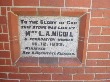
Article - St. Andrew’s Presbyterian Church, North Road, Gardenvale East
Handwritten document giving brief details on wording on foundation stone of St. Andrew’s church, undated and author unknown. Photocopy of pamphlet produced for the stewardship campaign 1957 for St. Andrew’s Presbyterian Church Gardenvale East, with several photos. It includes history as well as current situation at 1957. Photocopied notes and photo of the Army Hut used by Gardenvale Primary School in 1921 only as donated by church for and year then Reverted back to church use. Photocopy of letter to Glen Eira News and City Council re-proposed subdivision of church land from Robert W. Sinclair.st. andrew’s presbyterian church, foundation stones, nicoll l.a., heathcote-fletcher a. rev., north road, seach street, smith a. f.h. rev., mcneilage alex rev., gardenvale east, caulfield south, younger street, gardenvale east church, nicholls rev., rowlands w. rev., lang walter, sunday schools, yeaman f.e. rev., brown f.e., brick, towers, manse, choirs, groups, smith mrs., curtis e.e., morse roger, marryatt harry, pegler adrian, savill t., south caulfield, gardenvale primary school, sinclair robert w., dakin ms., campbell felicity -
Glen Eira Historical Society
Document - Elizabeth Street, 30, Elsternwick, formerly Trengrove
A two page typed research report dated 23/11/1988 by the Brighton Historical Society regarding the history of the large land area acquired by Peter Davis "in Melbourne's very early days" including the block later used for the house building in 1938 at 30 Elizabeth Street, Elsternwick. The report includes a brief history of the suburb of Ripponlea and the occupancy of 30 Elizabeth Street from 1938 to 1974 by Stanley Hannan. The file also includes one page of handwritten working notes for the typed report.elsternwick, elizabeth street, historical buildings, davis peter, caulfield, davis street, sinclair street, sargood frederick sir, bent thomas, bent street, rippon lea, ripponlea, word war 1914-1918, depression 1890s, depression 1929-1939, hannan stanley, rippon, bent elizabeth, brighton historical society, bullock hilary, sargood frederick james, sargood frederick thomas -
Glen Eira Historical Society
Document - Bramerton, Bambra Road, Caulfield
One page undated, unattributed, typed note about Bramerton, Bambra Road, listing owner, date, property description and acreage. The file also includes a one page handwritten, undated note about Bramerton, Bambra Road, built for Arthur Palmer Blake, mentioning the property’s possible use as a military convalescent hostel in 1918. This was researched from book Land Boom and Bust by Cannon.bramerton, bambra road, blake arthur palmer, crotonhurst, stables, military hospital, nursing home, armed forces, caulfield -
 Eltham District Historical Society Inc
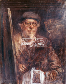
Photograph, Jorgensen, Justus, 1893-1975, Self portrait, Justus Jorgensen, founder of Montsalvat, c.1955
Founder of Montsalvat Reproduced Page 106 of Pioneers & Painters, edited by Alan Marshall (1971) Note: print in book and print copy are mirror imaged There was probably little earth building done in the district in this century until 1934, when Justus Jorgensen, architect and artist, bought land in Eltham and with his students and followers commenced to build the fascinating complex of buildings now know as ‘Montsalvat’. These buildings and his use of materials, both local stone and earth, and reclaimed materials, were to have a remarkable influence on the Eltham district-particularly in the period following World War II. The first building at ‘Montsalvat’ was a picturesque house of or rammed earth with a high-pitched roof. Jorgensen has used a variety of building materials but it is possibly his use of earth, both pise-de-terre and mud brick, which has had the most influence on the environmental building in Eltham in the post war years. By the end of the 1940s, an impressive array of adobe and pise buildings had been completed. – Alan Marshall, 1971, “Pioneers & Painters”This photo forms part of a collection of photographs gathered by the Shire of Eltham for their centenary project book,"Pioneers and Painters: 100 years of the Shire of Eltham" by Alan Marshall (1971). The collection of over 500 images is held in partnership between Eltham District Historical Society and Yarra Plenty Regional Library (Eltham Library) and is now formally known as the 'The Shire of Eltham Pioneers Photograph Collection.' It is significant in being the first community sourced collection representing the places and people of the Shire's first one hundred years.Digital image 4 x 5 inch Clr Reversal (3) Print 21 x 16.5 cm (printed in mirror image)justus jorgensen, montsalvat, pioneers and painters, shire of eltham pioneers photograph collection -
 Eltham District Historical Society Inc
Film - Video (DVD), Frank Stokes, Stokes Family, 1950-1977
Various family scenes taken from outside the family home on the southeast corner of the intersection of Nyora Road and Pitt Street with Eucalyptus Road. Also, scenes of the Stokes Orchard and equipment used, construction of water reservoir at the end of Nyora Road near Reynolds Road and Diosma Road as well as early stages of the Stokes Orchard housing development. Frank Stokes worked as a qualified accountant at Kennons leather factory in Burnley, while living at 1 Thomas Street, Mitcham. He suffered from migraines and wanted to go back to the land (he had previously worked on farms and orchards since coming to Australia in 1926 both in WA and Vic.). He first travelled to the district by train in July 1942 to find land with the intention to establish an orchard. By chance he met Arthur Bird of Bird Orchard (bounded by Pitt Street, Eucalyptus Road and Wattle Grove) and they got talking over their common interest. Arthur put Frank up for the night and pointed out the land, 158 acres- Taylor Estate- £900, part of Crown Allotment 15, Section 5, Parish of Nillumbik (CA15) somewhat diagonally opposite Bird Orchard. He applied through the Riverina Agency to purchase the land who in turn had to get permission from Canberra to sell as there was a new government regulation banning land sales except for immediate production. He obtained a loan on his Mitcham house of £600 @ 5% and paid £450 deposit with quarterly payments of £15 over 5 years. The title to the property was issued May 15, 1946. He was helped and advised by Arthur Bird who farmed the neighbouring orchard. Early 1943 he took possession and would catch the train out to Eltham on Fridays after work and began building a hut for shelter and to lock up tools. He was able to pay a neighbour (Hawkins) to help with clearing and fencing 25 acres and with a horse and single furrowed plow, planted approximately 2,500 fruit trees - cherries, peaches, plums, almonds, pears, apricots and lemons as well as a few apples and oranges; a massive job. A huge problem was hares and rabbits eating all the new buds off the tiny trees. As well as laying poison he painted the trees with a mixture of cow manure and lime. Often working by moonlight. It was extremely difficult to get wire and wire netting because of the war but after much effort he obtained a permit from the Agricultural Department for supplies in March 1944. In February 1945 he applied for a permit to build a “packing shed” as no house building allowed. It was to be 33 feet x 21 feet and cost £312. Constructed mostly from second-hand materials, which was hard to obtain, especially iron for roofing. Frank finished work at Kennons October 31, 1945, and in March 1946 he sold the Mitcham house for £1230 plus £170 for furniture. The family of five then moved into a very unfinished at Eltham, which was a struggle to weatherproof. Eventually rooms were divided off and lined with hessian bags and whitewashed. Their income was firewood (cut and sold), selling rockery stones and cut sweet bursaria. (It was discovered during the 1940s that Bursaria contained the sunscreen compound Aesculin. The RAAF utilised this compound from Bursaria during WW2 for pilots and gunners.) The orchard’s first fruit sale was a 1/2 case of Le Vanq peaches in December 1947 - 8 shillings. In 1956 plans for house were drawn and Glen Iris bricks purchased (1956 Olympic Rings variant). The building of the house commenced in 1957 - 12 feet of original packing shed removed – and was completed in 1959. Water was connected from newly built pressure storage on the property at the end of 1959 and the electricity connection for the first time at 3pm on April 29, 1960. In the mid-1970s the Shire of Eltham divided the orchard up into numerous rate-able parcel lots, which became unaffordable for Frank. Consequently, Stokes Orchard was turned into a housing development by Macquarie Builders and marketed as the Stokes Orchard Estate in two stages; Stage 1 encompassing Scarlet Ash Court, Ironbark Close and Peppermint Grove bounded by Nyora and Eucalyptus roads c.1976 and Stage 2 encompassing Stokes Place, Orchard Way, The Crest and The Lookout bound by Nyora and Diosma roads c.1979. The development of Orchard Way, The Crest and The Lookout did not proceed as planned due to the lack of the sewer along Diosma Road and so many of the proposed lots were incorporated into five-acre parcels instead. With the arrival of the sewer along Diosma Road many years later, most of these five-acre parcels have since been subdivided many times.Representative of the orchard growing areas of ElthamMP4 00:24:39; 426MB Digital file only - Digitised by EDHS from a DVD copy on loan from Beryl Bradbury (nee Stokes), daughter of Frank Stokes. 24 min duration compilation of home movie Super 8mm film shot by Frank Stokes brother-in-law.beryl bradbury (nee stokes) collection, frank stokes, nyora road, stokes orchard, stokes orchard estate, stokes place, video recording -
 Eltham District Historical Society Inc
Photograph, Tess Justine (Nillumbik Shire Council), Murray's Bridge over the Diamond Creek, Eltham North, 19 Feb 2022
Murray's Bridge over the Diamond Creek on the Diamond Creek Trail just prior to demolition and replacement with a new steel bridge. Heritage advice obtained by Nillumbik Shire Council, following a suggestion by the Eltham District Historical Society (EDHS), is that the original bridge appears to have been a simplified version of the Country Roads Board’s (CRB) standard timber bridge design of the early-to-mid 1920s. In c1990 Murray’s bridge was renovated with three recycled steel girders as part of a bike/pedestrian path in the reserve. During these alterations many parts of the bridge were removed, and some were replaced. Heritage advice indicates the condition of Murray’s bridge is poor. The remaining original parts are all in poor condition, with severe weathering, splitting and rot, especially to the stringers retained on the bridge. Heritage advice is that Murray’s Bridge does not have sufficient significance in the cultural history of the Nillumbik area to warrant inclusion in the Nillumbik Shire Heritage Overlay and also does not have sufficient significance as a rare survivor to warrant inclusion in the Nillumbik Shire Heritage Overlay. There are no indications in the historical record that this site was individually important to the cultural history of this area. EDHS is comfortable with the heritage advice provided to Council and has worked closely on this project with Council. EDHS has suggested some of the removed timbers be used in the vicinity of the bridge for landscaping and possibly seating, so as to retain these remnants close to the site of the original bridge, which is the last old timber bridge along the lower reaches of the Diamond Creek. Mary (Sweeney) Murray and John Wright Murray selected 80 acres, Lot C Section 16 and Lot 5 Section 17 Parish of Nillumbik, under an occupation license in 1866. John died in 1867 and freehold was granted to his son John in 1873. The farm was known as ‘Laurel Hill’. John Junior was an Eltham Shire councillor and sometime president from 1887 up until 1897. He added Lot A Section 16 to the farm in ca1888. John and his younger brother James arranged to rent/purchase Lot B Section 17, across Diamond Creek to the west, in ca1900. It appears that John and James farmed separately for a few years, with a new homestead built for James ad family on the high point of Lot B Section 17 in ca1910. John sold off Lot 5 Section 17 in 1912. When John died in 1912 James took over the land on both sides of the Diamond Creek. The old homestead on the west side of the Creek disappeared. A farm bridge over Diamond Creek from this period may have been located close to the northern boundary of the farm. John Langlands, owner of the farm known as ‘Ihurst’ on the west side of Diamond Creek to the south of the Murray’s land, died in 1907. In 1909 his land was then subdivided into 100 lots to become the ‘Glen Park Estate’. Other similar subdivisions of nineteenth century farms around Eltham in this period included the ‘Franktonia (or Beard’s) Estate’ to the northeast and ‘Bonsack’s Estate’ between Eltham and Greensborough. Soon after the opening of the railway extension line from Eltham to Hurstbridge in 1912, Glen Park and nearby residents including James Murray agitated for a railway station or siding to be located half-way between Eltham and Hurstbridge, so that the Glen Park residents who used the railway daily did not have to walk into the Eltham or Hurstbridge stations. Some believed Coleman’s Corner (opposite Edendale Farm) was an appropriate spot for the platform. James Murray was among those who thought the railway should be located on his land, closer to half-way between Eltham and Hurstbridge stations. The Railways Commissioners warned that the locals would have to fund these works themselves. The Glen Park Estate residents initially had difficulty accessing Eltham by road, with only an old low-level bridge over Diamond Creek at the south end of their estate. A new timber trestle bridge across the creek, now on Wattletree Road, was opened in 1915. Road access to the north was gained in 1927 when the new Murray’s Road, which crossed the Murray’s land, was built. Residents continued to agitate for a Glen Park station. By 1926 the Railways Commissioners’ preferred site was on the Murray’s land. They arranged an estimate of cost of a full-length platform. The estimate was too much for the locals, who in 1928 argued unsuccessfully for a shorter and hence cheaper platform. By 1929 Murray had agreed to donate the land, but the locals would still have to fund the works. Murray decided, unilaterally it would appear, to commence work on a timber trestle road bridge over Diamond Creek to link the new Murray Road to the proposed station. Late in 1929 he stopped work on the bridge, for reasons unknown, but started work again and completed the bridge in 1931. There is no further newspaper evidence of the campaign for the Glen Park station until 1939, when Murray and another local, Mr Maxwell, met the Railways Commissioner. The Glen Park locale now included 45 homes on the west side of the creek and 20 on the Eltham side. Most of the residents used the train every day. The Commissioner remained adamant that only a full-length platform could be built for safety reasons. It appears the campaign dissolved at this point. The increasing move to cars may have had an impact. There is no evidence of Murray’s bridge ever being connected to Murray’s Road, or of it having wide use for any purpose by locals. James Murray died in 1947 and the farm was taken over by his son James (Jim). Jim started to sell off parts of the farm in the 1980s, retaining a few acres around the ca1910 homestead and building a new house there. Recreation reserves were established along the creek. In ca1990 Murray’s bridge was renovated with steel girders as part of a bike/pedestrian path in the reserve. The old farmhouse was demolished in ca2014. * * * A theory posted on local community Facebook groups was that the bridge was built in the 1860s and was built to be more robust than was necessary for the movement of cows from one side of the creek to the other. It was suggested the robustness was necessary to support the weight of gold ore being transferred from a mine on Murray’s land to a railway siding near Murrays Bridge (presumably for transfer and processing at Diamond Creek). Perhaps this may have been one of the motivators for Murray, who really knows? Knowing when mining operations ceased on his land and how that fits the overall timeline would be useful but at the time the bridge was built, local gold production was minimal at best. The known facts are: • The railway line came to Eltham in 1902. • The extension of the railway from Eltham to Hurstbridge was constructed in 1912 so no railway line even existed through Murray's property until 1912 and the Victorian Railways maps at the time show no such siding on Murray’s property. • In 1923 a new company was formed in anticipation of the old Diamond Creek Gold Mine being re-opened. The mine had been previously closed and flooded. It was noted in the press at the time that the mine was within a mile of the railway. Nothing really came of this. • Construction of Murrays Bridge was commenced by James Murray in early 1929 in anticipation of a proposed flag station being nominated on his land, but work ceased shortly afterwards. The proposed flag station was commonly referred to as Glen Park as the residents of the Glen Park Estate wanted Option 1, located near them with the platform adjacent to Colemans corner. This was probably never going to fly as it was virtually in eyesight of Eltham station. Allandale Road was the third option, but the Commissioners' preferred option was No. 2 - on Murray's property. • The Railway Commissioners were not going to finance any such station and the works had to be funded by private landowners and residents, hence Murray investing in this himself. • Murray recommenced work two years later and finished his bridge in 1931 but unfortunately for him, the proposed flag station never eventuated. The bluestone siding you reference may well have been built by Murray as part of the proposed station platform. • Up until then, apart from the Main Road bridge, which was washed away in 1924, virtually all local crossings over the Diamond Creek were low lying bridges – Kaylocks Bridge at Brougham Street, Diamond Street bridge, Glen Park Road bridge. It is expected that Murray also had a low-lying bridge to connect his land either side of the creek. These were all washed away or severely damaged multiple times in the 1920s. Lessons were learnt, and Murrays Bridge appears to have been built in accordance with Country Road Board standards of the time. Flood damage was ongoing, and even more recently constructed raised bridges kept getting washed away, e.g., the new Wattle Tree Road bridge in 1958 just months after completion. Murray’s bridge was reinforced with steel some 30 years ago presumably to provide additional floodwater resistance, given the history of bridges disappearing in floodwaters. • In March 1932 it was reported in the Advertiser that there were still some prospectors operating around Eltham North who apart from further scarring the face of the earth over the previous two years had gained significant experience but little gold - hardly a driving factor for constructing a dedicated railway siding and bridge to transfer gold ore. It is far more probable that James Murray was hoping to have the railway station located on his property and invested his money by building the bridge to lead to it as well as a station platform. Had the station eventuated, it may well have driven up the value of his land for subdivision and new housing estates like the Glen Park Estate. That did not eventuate. Whilst the bridge was indeed old (90 years), the core structure being completed in 1931, it had been modified substantially from original and hence had no significant historic value – i.e., it was not a representative example of its type, construction, and age. Given that the bridge was not worthy of saving, the Eltham District Historical Society with Council’s support, and the Eltham Woodworkers group endeavoured to see what suitable sized timbers were salvageable to fabricate a commemorative seat. Unfortunately, the experts at the Woodworkers group were unable to salvage any suitable length/width timbers to fabricate the seat due to the presence of rot. Last remaining wooden trestle bridge on the Diamond Creek Trail just prior to demolition and replacementBorn digital image (27)diamond creek (creek), diamond creek trail, murrays bridge, ‘laurel hill’, john wright murray, mary (sweeney) murra, john murray jnr, james murray, john langlands, ‘ihurst’, ‘glen park estate’, beard's estate, franktonia, bonsack's estate, glen park estate, glen park railway station -
 Eltham District Historical Society Inc
Photograph, Tess Justine (Nillumbik Shire Council), Construction work on replacement of Murray's Bridge over the Diamond Creek, Eltham North, 31 Mar 2022
Construction work on replacement of Murray's Bridge over the Diamond Creek on the Diamond Creek Trail Mary (Sweeney) Murray and John Wright Murray selected 80 acres, Lot C Section 16 and Lot 5 Section 17 Parish of Nillumbik, under an occupation license in 1866. John died in 1867 and freehold was granted to his son John in 1873. The farm was known as ‘Laurel Hill’. John Junior was an Eltham Shire councillor and sometime president from 1887 up until 1897. He added Lot A Section 16 to the farm in ca1888. John and his younger brother James arranged to rent/purchase Lot B Section 17, across Diamond Creek to the west, in ca1900. It appears that John and James farmed separately for a few years, with a new homestead built for James ad family on the high point of Lot B Section 17 in ca1910. John sold off Lot 5 Section 17 in 1912. When John died in 1912 James took over the land on both sides of the Diamond Creek. The old homestead on the west side of the Creek disappeared. A farm bridge over Diamond Creek from this period may have been located close to the northern boundary of the farm. John Langlands, owner of the farm known as ‘Ihurst’ on the west side of Diamond Creek to the south of the Murray’s land, died in 1907. In 1909 his land was then subdivided into 100 lots to become the ‘Glen Park Estate’. Other similar subdivisions of nineteenth century farms around Eltham in this period included the ‘Franktonia (or Beard’s) Estate’ to the northeast and ‘Bonsack’s Estate’ between Eltham and Greensborough. Soon after the opening of the railway extension line from Eltham to Hurstbridge in 1912, Glen Park and nearby residents including James Murray agitated for a railway station or siding to be located half-way between Eltham and Hurstbridge, so that the Glen Park residents who used the railway daily did not have to walk into the Eltham or Hurstbridge stations. Some believed Coleman’s Corner (opposite Edendale Farm) was an appropriate spot for the platform. James Murray was among those who thought the railway should be located on his land, closer to half-way between Eltham and Hurstbridge stations. The Railways Commissioners warned that the locals would have to fund these works themselves. The Glen Park Estate residents initially had difficulty accessing Eltham by road, with only an old low-level bridge over Diamond Creek at the south end of their estate. A new timber trestle bridge across the creek, now on Wattletree Road, was opened in 1915. Road access to the north was gained in 1927 when the new Murray’s Road, which crossed the Murray’s land, was built. Residents continued to agitate for a Glen Park station. By 1926 the Railways Commissioners’ preferred site was on the Murray’s land. They arranged an estimate of cost of a full-length platform. The estimate was too much for the locals, who in 1928 argued unsuccessfully for a shorter and hence cheaper platform. By 1929 Murray had agreed to donate the land, but the locals would still have to fund the works. Murray decided, unilaterally it would appear, to commence work on a timber trestle road bridge over Diamond Creek to link the new Murray Road to the proposed station. Late in 1929 he stopped work on the bridge, for reasons unknown, but started work again and completed the bridge in 1931. There is no further newspaper evidence of the campaign for the Glen Park station until 1939, when Murray and another local, Mr Maxwell, met the Railways Commissioner. The Glen Park locale now included 45 homes on the west side of the creek and 20 on the Eltham side. Most of the residents used the train every day. The Commissioner remained adamant that only a full-length platform could be built for safety reasons. It appears the campaign dissolved at this point. The increasing move to cars may have had an impact. There is no evidence of Murray’s bridge ever being connected to Murray’s Road, or of it having wide use for any purpose by locals. James Murray died in 1947 and the farm was taken over by his son James (Jim). Jim started to sell off parts of the farm in the 1980s, retaining a few acres around the ca1910 homestead and building a new house there. Recreation reserves were established along the creek. In ca1990 Murray’s bridge was renovated with steel girders as part of a bike/pedestrian path in the reserve. The old farmhouse was demolished in ca2014. Born digital image (5)diamond creek (creek), diamond creek trail, murrays bridge, ‘laurel hill’, john wright murray, mary (sweeney) murra, john murray jnr, james murray, john langlands, ‘ihurst’, ‘glen park estate’, beard's estate, franktonia, bonsack's estate, glen park estate, glen park railway station -
 Eltham District Historical Society Inc
Document - Report, Tract Consultants Australia Pty Ltd, Eltham Cemetery: Towards a Master Plan, Nov 1987
BACKGROUND The Eltham Cemetery is of historic significance to the Eltham area. The Trust was established in 1858 and has administered and maintained the cemetery from that date right up to the present. Among the more noteworthy graves is that of Sir William Irvine, a former State Premier and Chief Justice of Victoria. Eltham Cemetery is surrounded on three sides by urban development. Montsalvat Artists Colony adjoins the remaining (eastern) side. A Joint Select Committee of Parliament called the “Mortuary Industry and Cemeteries Administration Committee" (MICA) enquired into the land requirements at the Eltham Cemetery in 1986. The MICA recommendations contained in its 1986 report are included in the Appendices attached to this report. Although the recommendations have not been adopted by the Government it is interesting to note that the MICA report recommended the use of the bulk of the land for cemetery purpose. In June of 1987, the Cemetery Trust was expanded to include additional members from the Eltham Community by the Minister for Health. At the same time, he instructed the Trust to resolve the land requirement issues. As a result of this Ministerial direction, Tract Consultants has been instructed by the Eltham Cemetery Trust to prepare a report addressing the issues raised in the Minister's letter (see Appendix 1) to the Trust. Principally, the study will examine options available for development of the Cemetery. These options will explore possible boundaries, cemetery design, vegetation, the overall environment, landscaping and financial planning for the Cemetery operations. Appendix 2 details the Cemetery Trusts Terms of Reference for the Study. Before commencing the study in detail, additional basic information was sought; viz: a) sub-soil and rock analysis; and b) feature survey by a Licensed Surveyor. The results from both exercises are included as appendices to this report. Section three includes a summary of the findings along with other analytical results. Also: Eltham Cemetery - planning bewteen 1859 to 1860; research by Alan Sheehan April 2015, collated by Harry Gilham, EDHS, April 2016 (2 pages) PROV Guide 5: Cemetery Records (8 pages), printed 7 May 2014Development of Eltham Cemeteryeltham cemetery trust, master plan, mica, montsalvat, mortuary industry and cemeteries administration committee, tract consultants -
 Eltham District Historical Society Inc
Opening of Meruka Childcare Co-operative, Meruka Park, 5 Meruka Dr, Eltham, April 1994
In 1919 J.B. North, a violinist with the then Melbourne Symphonic Orchestra, and Monsieur Leon Lambert, a French architect, who later designed the Glaciarium Ice Skating Rink, purchased three available farms, Looker's, Wright's and Taylor's, approximately 60 acres, the area running along the creek and being bordered by the present day Ryans Road, Karingal Drive and Sherbourne Road. The farms were used for orchards and market gardens. Leon Lambert designed and built two homes on the farm site, one for the North family, ‘Tralford’, and the other, ‘Glen Ellen’, for himself and his wife. The homes were considered as "brother and sister" and they each included in their design an identical bay window in the main living area. "Glen Ellen" originally comprised kitchen, lounge room, inglenook, dining room, bath room and sleepout. Although the home has been extended over the years, much of the original architecture has been retained including timber panelling and three fireplaces. The land was subdivided in approximately 1966 with "Glen Ellen" retaining approximately one half acre of land fronting Meruka Drive. The property then passed from the Charleston family to Gerald and Margaret Sutton in 1976 and again was sold in 1980 and lastly sold again in 1994. The Norths named their house 'Tralford'. According to Marjorie North, the name Meruka was suggested by Alan Gardner and so was apparently not used by the North family. The name appears to be of Indian origin and its connection with the land is not known. ‘Tralford’ stayed in the North family for many years. Eltham Council acquired the house to create Meruka Park. The house was used for some years by the Council as a community arts facility and as emergency accommodation. It fell into disrepair and was demolished about 1990. The Meruka Child Care Centre has been built on the site and incorporates some of the architectural features of the old house. The Co-op was opened in April 1994. The original drive flanked by large old cypress trees remains. These trees are considered to be of local heritage significance and for this reason Meruka Park is covered by a Heritage Overlay under the Nillumbik Planning Scheme. Part of the park has been preserved as habitat for rare local flora. LL's house, named ‘Glen Ellen’, remains in a well-preserved state and fronts Meruka Drive.cr pam sladden, eltham, meruka child care co-operative, meruka house, meruka park -
 Eltham District Historical Society Inc
Opening of Meruka Childcare Co-operative, Meruka Park, 5 Meruka Dr, Eltham, April 1994
In 1919 J.B. North, a violinist with the then Melbourne Symphonic Orchestra, and Monsieur Leon Lambert, a French architect, who later designed the Glaciarium Ice Skating Rink, purchased three available farms, Looker's, Wright's and Taylor's, approximately 60 acres, the area running along the creek and being bordered by the present day Ryans Road, Karingal Drive and Sherbourne Road. The farms were used for orchards and market gardens. Leon Lambert designed and built two homes on the farm site, one for the North family, ‘Tralford’, and the other, ‘Glen Ellen’, for himself and his wife. The homes were considered as "brother and sister" and they each included in their design an identical bay window in the main living area. "Glen Ellen" originally comprised kitchen, lounge room, inglenook, dining room, bath room and sleepout. Although the home has been extended over the years, much of the original architecture has been retained including timber panelling and three fireplaces. The land was subdivided in approximately 1966 with "Glen Ellen" retaining approximately one half acre of land fronting Meruka Drive. The property then passed from the Charleston family to Gerald and Margaret Sutton in 1976 and again was sold in 1980 and lastly sold again in 1994. The Norths named their house 'Tralford'. According to Marjorie North, the name Meruka was suggested by Alan Gardner and so was apparently not used by the North family. The name appears to be of Indian origin and its connection with the land is not known. ‘Tralford’ stayed in the North family for many years. Eltham Council acquired the house to create Meruka Park. The house was used for some years by the Council as a community arts facility and as emergency accommodation. It fell into disrepair and was demolished about 1990. The Meruka Child Care Centre has been built on the site and incorporates some of the architectural features of the old house. The Co-op was opened in April 1994. The original drive flanked by large old cypress trees remains. These trees are considered to be of local heritage significance and for this reason Meruka Park is covered by a Heritage Overlay under the Nillumbik Planning Scheme. Part of the park has been preserved as habitat for rare local flora. LL's house, named ‘Glen Ellen’, remains in a well-preserved state and fronts Meruka Drive.eltham, meruka child care co-operative, meruka house, meruka park, cr. peter graham, peter staples, richard allen, sheryl garbutt, bill penrose -
 Eltham District Historical Society Inc
Opening of Meruka Childcare Co-operative, Meruka Park, 5 Meruka Dr, Eltham, April 1994
In 1919 J.B. North, a violinist with the then Melbourne Symphonic Orchestra, and Monsieur Leon Lambert, a French architect, who later designed the Glaciarium Ice Skating Rink, purchased three available farms, Looker's, Wright's and Taylor's, approximately 60 acres, the area running along the creek and being bordered by the present day Ryans Road, Karingal Drive and Sherbourne Road. The farms were used for orchards and market gardens. Leon Lambert designed and built two homes on the farm site, one for the North family, ‘Tralford’, and the other, ‘Glen Ellen’, for himself and his wife. The homes were considered as "brother and sister" and they each included in their design an identical bay window in the main living area. "Glen Ellen" originally comprised kitchen, lounge room, inglenook, dining room, bath room and sleepout. Although the home has been extended over the years, much of the original architecture has been retained including timber panelling and three fireplaces. The land was subdivided in approximately 1966 with "Glen Ellen" retaining approximately one half acre of land fronting Meruka Drive. The property then passed from the Charleston family to Gerald and Margaret Sutton in 1976 and again was sold in 1980 and lastly sold again in 1994. The Norths named their house 'Tralford'. According to Marjorie North, the name Meruka was suggested by Alan Gardner and so was apparently not used by the North family. The name appears to be of Indian origin and its connection with the land is not known. ‘Tralford’ stayed in the North family for many years. Eltham Council acquired the house to create Meruka Park. The house was used for some years by the Council as a community arts facility and as emergency accommodation. It fell into disrepair and was demolished about 1990. The Meruka Child Care Centre has been built on the site and incorporates some of the architectural features of the old house. The Co-op was opened in April 1994. The original drive flanked by large old cypress trees remains. These trees are considered to be of local heritage significance and for this reason Meruka Park is covered by a Heritage Overlay under the Nillumbik Planning Scheme. Part of the park has been preserved as habitat for rare local flora. LL's house, named ‘Glen Ellen’, remains in a well-preserved state and fronts Meruka Drive.eltham, meruka child care co-operative, meruka house, meruka park, cr. john cohen -
 Eltham District Historical Society Inc
Opening of Meruka Childcare Co-operative, Meruka Park, 5 Meruka Dr, Eltham, April 1994
In 1919 J.B. North, a violinist with the then Melbourne Symphonic Orchestra, and Monsieur Leon Lambert, a French architect, who later designed the Glaciarium Ice Skating Rink, purchased three available farms, Looker's, Wright's and Taylor's, approximately 60 acres, the area running along the creek and being bordered by the present day Ryans Road, Karingal Drive and Sherbourne Road. The farms were used for orchards and market gardens. Leon Lambert designed and built two homes on the farm site, one for the North family, ‘Tralford’, and the other, ‘Glen Ellen’, for himself and his wife. The homes were considered as "brother and sister" and they each included in their design an identical bay window in the main living area. "Glen Ellen" originally comprised kitchen, lounge room, inglenook, dining room, bath room and sleepout. Although the home has been extended over the years, much of the original architecture has been retained including timber panelling and three fireplaces. The land was subdivided in approximately 1966 with "Glen Ellen" retaining approximately one half acre of land fronting Meruka Drive. The property then passed from the Charleston family to Gerald and Margaret Sutton in 1976 and again was sold in 1980 and lastly sold again in 1994. The Norths named their house 'Tralford'. According to Marjorie North, the name Meruka was suggested by Alan Gardner and so was apparently not used by the North family. The name appears to be of Indian origin and its connection with the land is not known. ‘Tralford’ stayed in the North family for many years. Eltham Council acquired the house to create Meruka Park. The house was used for some years by the Council as a community arts facility and as emergency accommodation. It fell into disrepair and was demolished about 1990. The Meruka Child Care Centre has been built on the site and incorporates some of the architectural features of the old house. The Co-op was opened in April 1994. The original drive flanked by large old cypress trees remains. These trees are considered to be of local heritage significance and for this reason Meruka Park is covered by a Heritage Overlay under the Nillumbik Planning Scheme. Part of the park has been preserved as habitat for rare local flora. LL's house, named ‘Glen Ellen’, remains in a well-preserved state and fronts Meruka Drive.eltham, meruka child care co-operative, meruka house, meruka park, rob hauser