Showing 2437 items matching "nineteenth century"
-
 Kew Historical Society Inc
Photograph - Flooding of the Yarra Valley at Kew East, 1974
... and extent of these inundations diminished. During the nineteenth... diminished. During the nineteenth century, the land abutting ...Flooding of the Yarra Valley, including that section of the Yarra bordering Kew and Kew East in the north and west of the municipality, was a regular occurrence. Extreme flood events of the Yarra River are recorded to have occurred in 1891, 1901, 1916, 1923 and 1934. The Municipality of Kew's response to these floods was to enact planning decisions restricting residential development in flood prone areas following the floods of 1916, 1921 and 1934. While floods continued after the development of the Upper Yarra Reservoir (construction 1948-57), the regularity and extent of these inundations diminished. During the nineteenth century, the land abutting the south side of the Yarra in Kew was devoted to dairy farming. In the twentieth century, before and after the construction of the Eastern Freeway, much of this low-lying area was used as golf courses and public parks.Late example of the capacity of the Yarra Valley at Kew to flood, even though drainage works and the Upper Yarra Reservoir had reduced their regularity.Original black and white print photograph of the low-lying land at East Kew under floodwater on 16 May 1974. The vantage point of the photographer is Lister Street. In the photo, the fences of the Kilby Farm can be seen. Flooding was caused by overflowing water in Glass' Creek and the River Yarra. Annotation verso: "Hay's Paddock op No.30 Lister Street / 16 May 1974 11.50am / R.L. 46.04"hays paddock, floods, yarra river, glass' creek, lister street -
 Kew Historical Society Inc
Photograph - Flooding of the Yarra Valley at Kew East, 1974
... and extent of these inundations diminished. During the nineteenth... diminished. During the nineteenth century, the land abutting ...Flooding of the Yarra Valley, including that section of the Yarra bordering Kew and Kew East in the north and west of the municipality, was a regular occurrence. Extreme flood events of the Yarra River are recorded to have occurred in 1891, 1901, 1916, 1923 and 1934. The Municipality of Kew's response to these floods was to enact planning decisions restricting residential development in flood prone areas following the floods of 1916, 1921 and 1934. While floods continued after the development of the Upper Yarra Reservoir (construction 1948-57), the regularity and extent of these inundations diminished. During the nineteenth century, the land abutting the south side of the Yarra in Kew was devoted to dairy farming. In the twentieth century, before and after the construction of the Eastern Freeway, much of this low-lying area was used as golf courses and public parks.Late example of the capacity of the Yarra Valley at Kew to flood, even though drainage works and the Upper Yarra Reservoir had reduced their regularity.Original black and white print photograph of the low-lying land at East Kew under floodwater on 16 May 1974. The vantage point of the photographer is Lister Street. Flooding was caused by overflowing water in Glass' Creek and the River Yarra. Annotation verso: "Lister Street looking north / Flood level / 16 May 1974 11.30am / R.L. 46.04"hays paddock, floods, yarra river, glass' creek, lister street -
 Kew Historical Society Inc
Photograph - Flooding of the Yarra Valley at Kew East, 1974
... and extent of these inundations diminished. During the nineteenth... diminished. During the nineteenth century, the land abutting ...Flooding of the Yarra Valley, including that section of the Yarra bordering Kew and Kew East in the north and west of the municipality, was a regular occurrence. Extreme flood events of the Yarra River are recorded to have occurred in 1891, 1901, 1916, 1923 and 1934. The Municipality of Kew's response to these floods was to enact planning decisions restricting residential development in flood prone areas following the floods of 1916, 1921 and 1934. While floods continued after the development of the Upper Yarra Reservoir (construction 1948-57), the regularity and extent of these inundations diminished. During the nineteenth century, the land abutting the south side of the Yarra in Kew was devoted to dairy farming. In the twentieth century, before and after the construction of the Eastern Freeway, much of this low-lying area was used as golf courses and public parks.Late example of the capacity of the Yarra Valley at Kew to flood, even though drainage works and the Upper Yarra Reservoir had reduced their regularity.Original black and white print photograph of Hay's Paddock under floodwater on 16 May 1974. The vantage point of the photographer is Keystone Crescent looking east. Flooding was caused by overflowing water in Glass' Creek and the River Yarra. Annotation verso: "Keystone Cr looking east / 16 May 1974 11.50am"hays paddock, floods, yarra river, glass' creek -
 Kew Historical Society Inc
Photograph - Flooding of the Yarra Valley at Kew East, 1974
... and extent of these inundations diminished. During the nineteenth... diminished. During the nineteenth century, the land abutting ...Flooding of the Yarra Valley, including that section of the Yarra bordering Kew and Kew East in the north and west of the municipality, was a regular occurrence. Extreme flood events of the Yarra River are recorded to have occurred in 1891, 1901, 1916, 1923 and 1934. The Municipality of Kew's response to these floods was to enact planning decisions restricting residential development in flood prone areas following the floods of 1916, 1921 and 1934. While floods continued after the development of the Upper Yarra Reservoir (construction 1948-57), the regularity and extent of these inundations diminished. During the nineteenth century, the land abutting the south side of the Yarra in Kew was devoted to dairy farming. In the twentieth century, before and after the construction of the Eastern Freeway, much of this low-lying area was used as golf courses and public parks.Late example of the capacity of the Yarra Valley at Kew to flood, even though drainage works and the Upper Yarra Reservoir had reduced their regularity.Original black and white print photograph of the low-lying land at East Kew under floodwater on 16 May 1974. The vantage point of the photographer is Lister Street. Flooding was caused by overflowing water in Glass' Creek and the River Yarra. Annotation verso: "Lister St looking same as No.3 / 16 May 1974 11.30"floods, yarra river, glass' creek, lister street -
 Kew Historical Society Inc
Photograph - Flooding of the Yarra Valley at Kew East, 1974
... and extent of these inundations diminished. During the nineteenth... diminished. During the nineteenth century, the land abutting ...Flooding of the Yarra Valley, including that section of the Yarra bordering Kew and Kew East in the north and west of the municipality, was a regular occurrence. Extreme flood events of the Yarra River are recorded to have occurred in 1891, 1901, 1916, 1923 and 1934. The Municipality of Kew's response to these floods was to enact planning decisions restricting residential development in flood prone areas following the floods of 1916, 1921 and 1934. While floods continued after the development of the Upper Yarra Reservoir (construction 1948-57), the regularity and extent of these inundations diminished. During the nineteenth century, the land abutting the south side of the Yarra in Kew was devoted to dairy farming. In the twentieth century, before and after the construction of the Eastern Freeway, much of this low-lying area was used as golf courses and public parks.Late example of the capacity of the Yarra Valley at Kew to flood, even though drainage works and the Upper Yarra Reservoir had reduced their regularity.Original black and white print photograph of the low-lying land at East Kew under floodwater on 16 May 1974. The vantage point of the photographer is at Willsmere Road. The road itself is underwater.Annotation verso: "Willsmere Rd / Same as No.7 / 16 May 1974 11.15am"floods, yarra river, willsmere road -
 Kew Historical Society Inc
Photograph - Flooding of the Yarra Valley at Kew East, 1974
... and extent of these inundations diminished. During the nineteenth... diminished. During the nineteenth century, the land abutting ...Flooding of the Yarra Valley, including that section of the Yarra bordering Kew and Kew East in the north and west of the municipality, was a regular occurrence. Extreme flood events of the Yarra River are recorded to have occurred in 1891, 1901, 1916, 1923 and 1934. The Municipality of Kew's response to these floods was to enact planning decisions restricting residential development in flood prone areas following the floods of 1916, 1921 and 1934. While floods continued after the development of the Upper Yarra Reservoir (construction 1948-57), the regularity and extent of these inundations diminished. During the nineteenth century, the land abutting the south side of the Yarra in Kew was devoted to dairy farming. In the twentieth century, before and after the construction of the Eastern Freeway, much of this low-lying area was used as golf courses and public parks.Late example of the capacity of the Yarra Valley at Kew to flood, even though drainage works and the Upper Yarra Reservoir had reduced their regularity.Original black and white print photograph of the low-lying land at East Kew under floodwater on 16 May 1974. The photograph is of Hyde Park looking north-east.Annotation verso: "Hyde Park looking nth-east / Flood Level / 16 May 1974 11.15am / R.L. 46.61"floods, yarra river, hyde park -
 Kew Historical Society Inc
Photograph - Flooding of the Yarra Valley at Kew, 1974
... and extent of these inundations diminished. During the nineteenth... diminished. During the nineteenth century, the land abutting ...Flooding of the Yarra Valley, including that section of the Yarra bordering Kew and Kew East in the north and west of the municipality, was a regular occurrence. Extreme flood events of the Yarra River are recorded to have occurred in 1891, 1901, 1916, 1923 and 1934. The Municipality of Kew's response to these floods was to enact planning decisions restricting residential development in flood prone areas following the floods of 1916, 1921 and 1934. While floods continued after the development of the Upper Yarra Reservoir (construction 1948-57), the regularity and extent of these inundations diminished. During the nineteenth century, the land abutting the south side of the Yarra in Kew was devoted to dairy farming. In the twentieth century, before and after the construction of the Eastern Freeway, much of this low-lying area was used as golf courses and public parks.Late example of the capacity of the Yarra Valley at Kew to flood, even though drainage works and the Upper Yarra Reservoir had reduced their regularity.Original black and white print photograph of the low-lying land at East Kew under floodwater on 16 May 1974. The photograph is taken from 43 Kellett Grove.Annotation verso: "Kellett Gve No.43 / Flood Level / 16 May 1974 11.40am"floods, yarra river, kellett grove -
 Sunbury Family History and Heritage Society Inc.
Photograph, Sunbury & District Heritage Association Inc, Vineyards Exhibition, August 1996
... there. By the end of the nineteenth century and limited spending power... there. By the end of the nineteenth century and limited spending power ...The vineyards exhibition was mounted by the Sunbury & District Heritage Association in the former George Evans Museum from August 1996 to January 1997. It featured the establishment of the vineyards and the wine industry in Sunbury from the 1860s to the present day. From the early days of European settlement in Sunbury, it was found that the soils and climate suited the growing of grapes, especially the east facing slopes along Vineyard Road. A number of people of German origin established vineyards along there. By the end of the nineteenth century and limited spending power as a result of the 1890s depression, the demand for wine declined in Victoria with beer being the preferred beverage.While Phylloxera destroyed the vines in many areas of Victoria, Sunbury's grapevines were not affected. As the demand for wine increased in the 1960s - 70s, some vineyards in the Sunbury area were replanted.The vineyards established in Sunbury in the 1860s were one of the earliest agricultural pursuits taken up by European settlers in the area and remained an important industry for 40 years.A non-digital coloured photograph of a display board advertising an exhibition of vineyards in the Sunbury area.vineyards, sunbury, vignerons, wine production -
 Parks Victoria - Point Hicks Lightstation
Cabinet
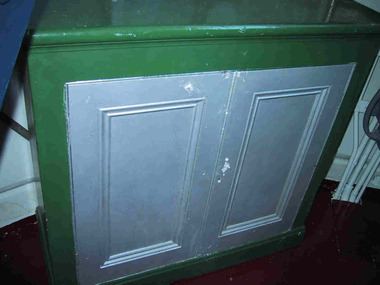
... The two-door nineteenth century cabinet was purpose built...-door nineteenth century cabinet was purpose built with a curved ...The two-door nineteenth century cabinet was purpose built with a curved back to fit the proportions of the lantern room interior and is likely to date from 1888-89 when the new lighthouse was fitted out and provided with furnishings and fixtures. The Public Works Department provided a range of lightstation furnishings including office desks and cabinets, and domestic settings for keepers’ quarters, with nineteenth century items often stamped with a crown motif and the PWD monogram. The curved cabinets installed in lantern rooms however do not appear to display this small feature. The cabinet needed to be custom made to fit the proportions of the room, and for this reason it was possibly made on site or perhaps even supplied by Chance Bros as part of the entire lantern room installation. The company usually provided timber panelling for their lantern room interiors (since removed from Point Hicks), and a cabinet may have been included in the assemblage. It may not have originally been painted; today doors area grey/silver colour and the rest of the cabinet is emerald green. It is not known whether it is freestanding or fixed to the wall. A similar cabinet with panelled doors remains in the Gabo Island lighthouse and evidence of green paint on the wood indicates that the cabinet frame was also formerly painted green but later stripped to reveal the wood finish. The Cape Nelson lantern room has a curved cabinet with the same door type but has a drawer above each door. It too was formerly painted emerald green before it was stripped back to its present wood finish. Cape Schanck’s lantern room cabinet is unique for its curved front as well as curved back, and it stands on a skirting. The two doors are in the same style, although they open with a brass knob. Further research into these distinctive cabinets may resolve the interesting question of their construction. The Point Hicks cabinet is a unique, original feature of the lighthouse lantern room and has first level contributory significance for its historic values and provenance. The Point Hicks cabinet has two doors, each framed and beaded around a central panel, and there is a simple door knob. The back is curved and the front is straight and the doors are painted a grey/silver colour and the rest of the cabinet is emerald green. -
 Mission to Seafarers Victoria
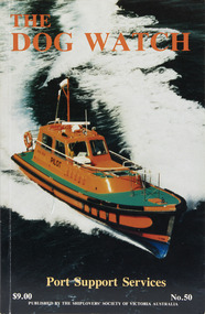
Journal (item) - Periodicals-Annual, Shiplovers' Society of Victoria, The Annual Dog Watch
... in the Nineteenth Century - M.A. Syme - 45 The Schooner Enterprise - Roy... Port Services in the Nineteenth Century - M.A. Syme - 45 ...This journal provides the reader with glimpses of the adventures and hardships of a seaman's life. Many of the stories are of sailing ships.Contributes to our knowledge of the importance of shipping and places on record those stories of the sea which would otherwise be lost.Contents Editorial - Fifty Years Past - Miss S.A.E. Strom - 5 The Port of Melbourne — A Historical View - Andy Gash - 8 We Moved the Cargoes - J. Beggs - 15 A Chaplain’s Chatterings - W.S. McUtchen - 19 Pilots - Late C.E. Borwick - 26 Up the River — Down the River - Lloyd Taylor - 27 Port Services in the Nineteenth Century - M.A. Syme - 45 The Schooner Enterprise - Roy Stuart - Roy Stuart - 49 The Port Phillip Sea Pilot Service - Capt. Michael Carolin - 53 Streamers - G.M. Naug - 60 Errata - - 60 War Diary of H.M.A.S. Bendigo Part 2 1942 - T.W. Richardson - 61 Fire Fighting Services in the Port of Melbourne - Frank M. Stockton - 75 Shipwreck - A. Roland Jones - 81 The Diary of Peter Charles Iredale - Colin Wilson - 87 The John Oxley - R.N. Thiele - 95 The Volunteer - Bert Attwood - 100 Sailing in Wharanui - W.P. Shemmeld - 101 Book Reviews - - 110 The Most Fascinating Immigrant — Marco Polo - K. Shewan - 111sailing ships, steamships, shipping, seafaring life, shiplovers' society of victoria, dog watch -
 Ringwood and District Historical Society
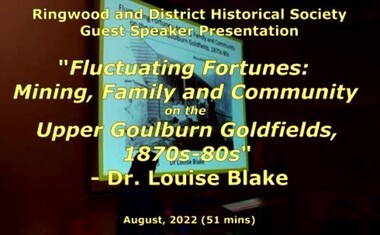
Mixed media - Video, RDHS Guest Speaker Presentation - "Fluctuating Fortunes on the Upper Goulburn Goldfields 1870s-1880s" - Dr. Louise Blake
... on the nineteenth-century goldfields in Australia and New Zealand. Inspired..., families, and communities on the nineteenth-century goldfields ...Digitised video (2.66GB) Duration: 51 minutes. Recorded August, 2022 (Video is available for viewing at Ringwood & District Historical Society Archives by appointment)Presenter: Louise Blake is a writer and historian with an interest in the stories of women, families, and communities on the nineteenth-century goldfields in Australia and New Zealand. Inspired by her family connection to the gold mining settlement of Woods Point, Louise completed a PhD on Women and Community on the Upper Goulburn Goldfields in north-east Victoria in 2019. In this talk Louise will share her research on Lawrence and Esther Chubb, who lived and worked at Gaffneys Creek on the Upper Goulburn Goldfields in the 1870s and 80s. In a series of letters Lawrence wrote to his family in England, and now held by the State Library of Victoria, Lawrence shared his early struggles as an independent miner on the central Victorian goldfields, his protracted courtship with Esther, the ordinary intimacies of their life at Gaffneys Creek, the work that Esther did to support the family in this remote mining region, as well as the material and emotional support provided by and to family, friends and neighbours. A rare and revealing source, these letters help to expand our understanding of the lived experience of mining families, particularly the work that women did to sustain families and communities, in this period of waged labour and tribute mining in Victoria. -
 Eltham District Historical Society Inc
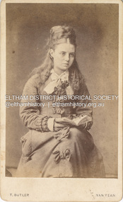
Photograph, T. Butler, Believed to be Sarah Shillinglaw, c.1870
... ) are the most common form of photograph from the nineteenth century...) are the most common form of photograph from the nineteenth century ...Photographer: T. Butler, Yan Yean In this image her hair style and dress is typical of the early 1870s Photo taken by T. Butler of Yan Yean. No information has yet been discovered of when T. Butler operated at Yan Yean though it is noted that Sarah's children with Charles Aldous (post 1880) were born in Yan Yean. CARTE-DE-VISITE (cdv) 1857-1890 Cartes-de-visite (cdv's) are the most common form of photograph from the nineteenth century, generally measuring two and a half inches by four and an eighth inches (6.3 x 10.5 cm) when mounted, sepia toned, mounted on a card which was generally printed with the photographer's name and address on the back or beneath the portrait. - Frost, Lenore; Dating Family Photos 1850-1920; Valiant Press Pty. Ltd., Berwick, Victoria 1991marg ball collection, shillinglaw family photo album 1, t. butler photographer yan yean, 1870, sarah aldous (nee shillinglaw 1854-1925) -
 Eltham District Historical Society Inc
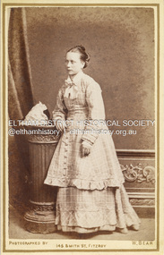
Photograph, W. Bear, Possibly Catherine Shillinglaw, c.1880
... of photograph from the nineteenth century, generally measuring two... of photograph from the nineteenth century, generally measuring two ...Catherine Shillinglaw was born November 13, 1852 at Coburg, Victoria. In 1897 she married Edward Henry Bottle (1854-1900). Catherine died April 7, 1934 at Northcote, Victoria. According to Sands & McDougall Melbourne Directory, W. Bear was active at 145 Smith Street, Fitzroy from 1877 to 1882 CARTE-DE-VISITE (cdv) 1857-1890 Cartes-de-visite (cdv's) are the most common form of photograph from the nineteenth century, generally measuring two and a half inches by four and an eighth inches (6.3 x 10.5 cm) when mounted, sepia toned, mounted on a card which was generally printed with the photographer's name and address on the back or beneath the portrait. - Frost, Lenore; Dating Family Photos 1850-1920; Valiant Press Pty. Ltd., Berwick, Victoria 1991marg ball collection, shillinglaw family photo album 1, 1877-1882, 1880, catherine bottle (nee shillinglaw 1852-1934), unknown, w. bear photographer 145 smith st fitzroy -
 Eltham District Historical Society Inc
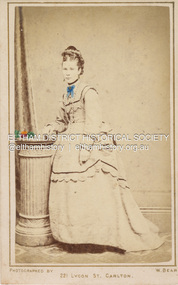
Photograph, W. Bear, Sarah Shillinglaw, c.1874
... of photograph from the nineteenth century, generally measuring two... of photograph from the nineteenth century, generally measuring two ...Sarah Shillinglaw married Charles Edward Aldous in June 1880. In this image she is depicted without any wedding ring on her left ring finger and her hair style and dress is typical of the early 1870s. Photographer William Bear operated from 221 Lygon Street, Carlton between 1873-1875. CARTE-DE-VISITE (cdv) 1857-1890 Cartes-de-visite (cdv's) are the most common form of photograph from the nineteenth century, generally measuring two and a half inches by four and an eighth inches (6.3 x 10.5 cm) when mounted, sepia toned, mounted on a card which was generally printed with the photographer's name and address on the back or beneath the portrait. - Frost, Lenore; Dating Family Photos 1850-1920; Valiant Press Pty. Ltd., Berwick, Victoria 1991marg ball collection, shillinglaw family photo album 1, sarah aldous (nee shillinglaw 1854-1925), w. bear photographer 221 lygon st carlton, 1873-1875, 1874 -
 Eltham District Historical Society Inc
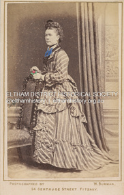
Photograph, W.J. Burman, Sarah Shillinglaw, c.1875
... form of photograph from the nineteenth century, generally... form of photograph from the nineteenth century, generally ...Sarah Shillinglaw married Charles Edward Aldous in June 1880. In this image she is depicted without any wedding ring on her left ring finger. In this image her hair style and dress is typical of the early 1870s. Photographer W.J. Burman operated from 94 Gertrude Street, Fitzroy 1874-1875. CARTE-DE-VISITE (cdv) 1857-1890 Cartes-de-visite (cdv's) are the most common form of photograph from the nineteenth century, generally measuring two and a half inches by four and an eighth inches (6.3 x 10.5 cm) when mounted, sepia toned, mounted on a card which was generally printed with the photographer's name and address on the back or beneath the portrait. - Frost, Lenore; Dating Family Photos 1850-1920; Valiant Press Pty. Ltd., Berwick, Victoria 1991marg ball collection, shillinglaw family photo album 1, sarah aldous (nee shillinglaw 1854-1925), 1874-1875, 1875, w. burman photographer 94 gertrude st fitzroy -
 Orbost & District Historical Society
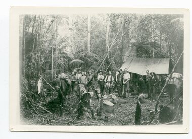
black / white photograph, 1897
... of the nineteenth century that the professional training of surveyors became... of the nineteenth century that the professional training of surveyors became ...Link with item 1178. This is a surveyors' camp in the McCulloch Ranges, Murrangowar, April, 1897. Included in the photograph are: L. Thorn; Pearson; L. Coburn, Clem Bates; Sam Blacklock with a packhorse. They were surveying for a road or railway. Surveyors were among the first European settlers to arrive in Australia. A Surveyor-General was present on the First Fleet, as well as the first two ships which landed in South Australia. These men were issued with instructions to record observations in a journal that included the country’s general appearance, its soil, flora and fauna and the customs and language of local inhabitants. The conditions they worked in were harsh and they embarked on journeys with drays carrying cumbersome surveying and camping equipment, spending months camping out in the bush and mapping the land. It was not until well into the second half of the nineteenth century that the professional training of surveyors became mandatory in Australia.This is a pictorial record of a surveyors' camp in the late 19th century.A black / white photograph of a group of men standing in front of a tent / camp in a dense bush setting.surveyor's-camp-mccullochs-ranges-murrangowar land-settlement -
 Unions Ballarat
Power, action and belief: A new sociology of knowledge?, 1986
... exhibitions and power during the nineteenth century / Gordon J. Fyfe... exhibitions and power during the nineteenth century / Gordon J. Fyfe ...Sociological text that explores social structure. Marxist and Durkeimian influences. Editor's introduction: Power/knowledge and the dissolution of the sociology of knowledge / John Law -- Art exhibitions and power during the nineteenth century / Gordon J. Fyfe -- The Politics of schism: routinisation and social control in the International Socialists/Socialist workers' party / Steve Rayner -- The Social preconditions of radical scepticism / Mary Douglas -- The values of quantification / Jean Lave -- 'Interests' in political analysis / Barry Hindess -- Interactive-orientation and argumentation in scientific texts / Steven Yearley -- The Question of ideology: Althusser, Pecheux and Foucault / Mark Cousins and Athar Hussain -- On authority and its relationship to power / Barry Barnes -- Some elements of a sociology of translation: domestication of the scallops and the fishermen of St Brieuc Bay / Michel Callon -- On the methods of long-distance control: vessels, navigation and the Portuguese route to India / John Law -- The Powers of association / Bruno Latour. Socially and politically significant. Broad relevance to how societies work.Paperback; white background; blue and black text; price sticker; 280 pages.Back cover: contributors' and editor's bios. Front cover: editor's name and title.btlc, ballarat trades and labour council, ballarat trades hall, power, knowledge, art, socialism, sociology, politics, science, ideology -
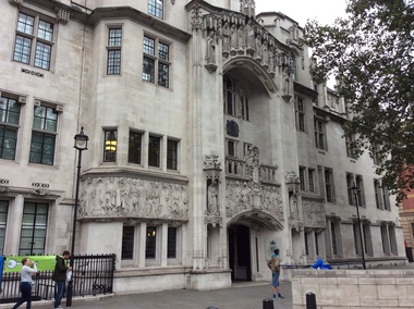 Ballarat Heritage Services
Digital photograph, Exterior, Supreme Court, London, 2016, 19/09/2016
... of the nineteenth century, since when the two activities have tended... of the nineteenth century, since when the two activities have tended ...1 October 2009 marks a defining moment in the constitutional history of the United Kingdom: transferring judicial authority away from the House of Lords, and creating a Supreme Court for the United Kingdom in the historic setting of the former Middlesex Guildhall on Parliament Square. In this location, The Supreme Court forms part of a pre-existing quadrangle made up of the Houses of Parliament, Westminster Abbey and Treasury. As civil administration developed, it tended to be conducted by the Justices of the Peace and its offices were often co-located with the first tier of the courts. This close association reached a peak in the latter half of the nineteenth century, since when the two activities have tended to separate. In April 2005, all Magistrates’ Court houses were transferred from the care of County Councils to the Department of Constitutional Affairs (DCA). (https://www.supremecourt.uk/about/history.html, accessed 21 September 2016)london, supreme court, law, legal -
 Parks Victoria - Wilsons Promontory Lightstation
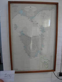
Nautical chart
... in the nineteenth century was known as the ‘Eye of the Needle’. It covers... in the notorious Bass Strait passage, which in the nineteenth century ...Used as display in AMSA workshop foyer, Moorabbin, Vic. Nautical charts x 2 , The framed and glazed chart identifies strategic points in the notorious Bass Strait passage, which in the nineteenth century was known as the ‘Eye of the Needle’. It covers the whole of Tasmania, Bass Strait and the islands, and the lower part of Victoria with its coastline between Cape Otway and Gabo Island. The chart has an electric cord connecting it to a wall switch which enables a series of small lights to flash on strategic geographical locations.. While it is not known if it is original to Wilsons Promontory, it certainly elates to its location. A similar chart at Cape Otway shows less of Tasmania and is not electrified. Gabo Island Lightstation has two large framed charts; one is the same as the Wilsons Promontory example but without the lights and the other is entirely different, focussing on the east coast between Point Hicks and Montague Island. The Wilsons Promontory chart is unique as an illuminated version of the other charts and has first level significance if its provenance to the lightstation can be confirmed.The framed and glazed chart has an electric cord connecting it to a wall switch which enables a series of small lights to flash on strategic geographical locations.Yes -
 Parks Victoria - Gabo Island Lightstation
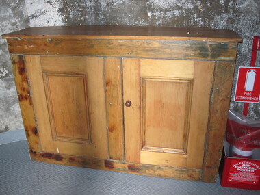
Cabinet
... Cupboard is original to Lighthouse. This nineteenth century... Cupboard is original to Lighthouse. This nineteenth century cedar ...Cupboard is original to Lighthouse. This nineteenth century cedar furnishing has two doors and one internal shelf. It remains in the lighthouse although its original location was probably the lantern room, where similar surviving cabinets are more typically found. It was purpose built for the lighthouse with a curved back to fit the proportions of the tower interior with the wood reputed to have originated from a partition in the assistant lightkeepers’ houses, and the cupboard doors possibly crafted at a different time. Curved cabinets similar to this example can be found at three other early lighthouses investigated by this study. It is possible that these specially designed cabinets were included in the standard complement of furnishings provided to the colony’s lightstations by the Victorian Public Works Department. Other similar cabinets with curved backs remain in the Point Hicks Lighthouse and at Cape Nelson (two examples )and Cape Schanck, which has a curved front as well as back .The Gabo Island cabinet has first level contributory significance for its historic value, uniqueness, provenance to the lightstation and clear association with the functions of the lighthouse lantern room.Two door wooden (cedar) cabinet. One internal shelf, panelled, curved back. Doors are attached. Frame has been stripped, doors are unpainted. -
 Bacchus Marsh & District Historical Society
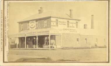
Photograph, Hall of Commerce, corner Main and Graham Streets, Bacchus Marsh. 1883
... of retail development in Bacchus Marsh in the late nineteenth... of retail development in Bacchus Marsh in the late nineteenth ...Bacchus Marsh Express of 7 November 1874 reports that this building was designed and erected by Mr Jeremiah Ryan for Mr H. G. Salter, draper. Mr Salter gave the name of "Hall of Commerce" to the building, a term in common usage at the time. The building was of a substantial size. In the Express of January 4 1879 Messrs Basham and Bradley advertised a wide variety of goods including drapery, millinery, ready-made clothing, boots and shoes and furniture. At the front of the building was the first pavement in the township. This photo forms a contrast with the photograph (also taken by Stevenson & McNicoll in 1883) of Timmons Clothier and Draper, but depicting an older building from 1857. This business was on the verge of closure, Mr Timmons conducting his business as a travelling salesman, taking his goods by horse and cart to outlying districts. The image provides an example of the growing scale of retail development in Bacchus Marsh in the late nineteenth century.This photograph is a record of a prominent commercial building that has undergone substantial change. The image shows the original upper floor which was destroyed by fire in 1928.The building retains its usage as a commercial premises.Small sepia unframed photograph on card with gold border framing photograph. Housed in the album, 'Photographs of Bacchus Marsh and District in 1883 by Stevenson and McNicoll'. Photograph of a two storey brick building with a front verandah. Various signage on second storey front and side, and on verandah, including: Hall of Commerce. Boots & Shoes. Men and Boy's Clothing. Furniture and Bedding. J. Carter Outfitter. Basham & Bradley. Milliners and Dressmakers. General Drapers. General Drapery. Warehouse. Latter signage obscures earlier signage. The photographer has captured a young girl sitting on a bench at the front of the store.On the front: Stevenson & McNicoll. Photo. 108 Elizabeth St. Melbourne. COPIES CAN BE OBTAINED AT ANY TIME. On the back: LIGHT & TRUTH inscribed on a banner surmounted by a representation of the rising sun. Copies of this Portrait can be had at any time by sending the Name and Post Office Money Order or Stamps for the amount of order to STEVENSON & McNICOLL LATE BENSON & STEVENSON, Photographers. 108 Elizabeth Street, MELBOURNE. Handwritten: Hall of Commerce. Cr. Main + Graham Sts built 1874 by Jeremiah Ryan. Destroyed by fire 1928. Courtesy Mrs. Jeremeas. Photo 1883.stevenson and mcnicoll 1883 photographs of bacchus marsh and district, shops bacchus marsh vic., bacchus marsh hall of commerce -
 Glenelg Shire Council Cultural Collection
Functional object - Kerosene Container, Dandy, 1900s
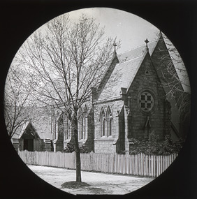
... throughout Victoria in the nineteenth century. The building... throughout Victoria in the nineteenth century. The building ...This glass kerosene lamp was used at St Peter's Church of England at Cape Bridgewater. From Victorian Heritage Database - St. Peter's Anglican Church (former) is a small sandstone church, located at the end of Bridgewater Fire Station Road. The church was constructed between 1883-1884, as a result of lobbying by the congregation and the Reverend Allnutt to establish an Anglican Church in the area. The area was predominately Presbyterian and Methodist, so such a fine church was somewhat unusual. There was obviously much community support for the establishment of the church; the land was donated by Kennedy, a nearby landholder, and the stone was quarried for free at Mount Pleasant, owned by the Kittson family. The church was designed gratis by the ecclesiastical architect, Mr. Casselli of Ballarat, who designed many significant buildings throughout Victoria in the nineteenth century. The building contractors were a local firm, Messrs. Benson and Hardie. The church retains a high degree of integrity externally, and is in good condition. This item is significant because it demonstrates early methods of storing fuel. It is also connected to St Peter's Anglican Church in cape Bridgewater which is now a visitor accommodationA glass container with a metal sleeve. The top of the glass container has a metal opening and screw top as well as a spout for pouring. There is a metal carry handle with a wooden cylinder in the middle for carrying. This is only fixed to the container on one side as the metal eyelet on one side has broken off. The metal sleeve on the glass container has embossed pattering above and below the word - Dandy. There is an old carboard label attached to the top with string.Metal sleeve - DANDY Label -This kerosene container was used in / St Peter's Church of E / Cape Bridgewaterreligion, church, place of worship, cape bridgewater, st peters church, anglican, glenelg shire, glenelg, portland, fuel, kero, kerosene, light -
 The Beechworth Burke Museum
Photograph - Lantern Slide, c1900
... ' device in the mid-Nineteenth Century. Photographic lantern slides...' device in the mid-Nineteenth Century. Photographic lantern slides ...Image taken in c.1900 of Albert Road, Beechworth, showing surrounding landscape. Lantern slides, sometimes called 'magic lantern' slides, are glass plates on which an image has been secured for the purpose of projection. Glass slides were etched or hand-painted for this purpose from the Eighteenth Century but the process became more popular and accessible to the public with the development of photographic-emulsion slides used with a 'Magic Lantern' device in the mid-Nineteenth Century. Photographic lantern slides comprise a double-negative emulsion layer (forming a positive image) between thin glass plates that are bound together. A number of processes existed to form and bind the emulsion layer to the base plate, including the albumen, wet plate collodion, gelatine dry plate and Woodburytype techniques. Lantern slides and magic lantern technologies are seen as foundational precursors to the development of modern photography and film-making techniquesThis glass slide is significant because it provides insight into Beechworth's social amenities and religious infrastructure in the late Nineteenth Century. It is also an example of an early photographic and film-making technology in use in regional Victoria in the time period.Thin translucent sheet of glass with a square image printed on the front and framed in a black backing. It is held together by metals strips to secure the edges of the slide.burke museum, beechworth, lantern slide, slide, glass slide, plate, burke museum collection, photograph, monochrome, 1900s, landscape, streetscape, albert road -
 The Beechworth Burke Museum
Photograph - Lantern Slide, c1900
... with a 'Magic Lantern' device in the mid-Nineteenth Century... with a 'Magic Lantern' device in the mid-Nineteenth Century ...This image of a man is possible an early version of the modern photographic technique the 'selfie'. Lantern slides, sometimes called 'magic lantern' slides, are glass plates on which an image has been secured for the purpose of projection. Glass slides were etched or hand-painted for this purpose from the Eighteenth Century but the process became more popular and accessible to the public with the development of photographic-emulsion slides used with a 'Magic Lantern' device in the mid-Nineteenth Century. Photographic lantern slides comprise a double-negative emulsion layer (forming a positive image) between thin glass plates that are bound together. A number of processes existed to form and bind the emulsion layer to the base plate, including the albumen, wet plate collodion, gelatine dry plate and Woodburytype techniques. Lantern slides and magic lantern technologies are seen as foundational precursors to the development of modern photography and film-making techniques.This glass slide is significant because it provides insight into Beechworth's social amenities and religious infrastructure in the late Nineteenth Century. It is also an example of an early photographic and film-making technology in use in regional Victoria in the time period.Thin translucent sheet of glass with a square image printed on the front and framed in a black backing. It is held together by metals strips to secure the edges of the slide.burke museum, beechworth, lantern slide, slide, glass slide, plate, burke museum collection, photograph, monochrome -
 Wodonga & District Historical Society Inc
Clothing - Hamilton-Smith Broderie Anglaise Collar c. late 1800s - early 1900s
... in the nineteenth century. In the nineteenth and early twentieth century... in the nineteenth century. In the nineteenth and early twentieth century ...The Hamilton-Smith collection was donated by the children of Grace Mary Hamilton-Smith nee Ellwood (1911-2004) and John Hamilton-Smith (1909-1984) who settled in Wodonga in the 1940s. The Ellwood family had lived in north-east Victoria since the late 1800s. Grace’s mother, Rosina Ellwood nee Smale, was the first teacher at Baranduda in 1888, and a foundation member of the C.W.A. Rosina and her husband Mark retired to Wodonga in 1934. Grace and John married at St. David’s Church, Albury in 1941. John was a grazier, and actively involved in Agricultural Societies. The collection contains significant items which reflect the local history of Wodonga, including handmade needlework, books, photographs, a wedding dress, maps, and material relating to the world wars. This collar was made using the broderie anglaise needlework technique that incorporates embroidery, cutwork and needle lace. This technique originated in sixteenth century Europe and became popular in England in the nineteenth century. In the nineteenth and early twentieth century prior to the mass production of clothing and textiles, needlework, alongside motherhood, was the defining work of women. Hand sewing and embroidery was central in the everyday lives and domestic roles of women.This item is unique, handmade and has a known owner. It forms part of a significant and representative historical collection which reflects the local history of Wodonga. It contributes to our understanding of social and family life in early twentieth century Wodonga, as well as providing interpretative capacity for themes including local history, social history and women’s history.A white cotton collar from the Edwardian period with broderie anglaise embroidery. hamilton-smith, hamilton-smith collection, needlework, clothing, sewing, embroidery, women, domestic, edwardian -
 The Beechworth Burke Museum
Photograph - Lantern Slide, c1900
... of the nineteenth-century. This trend began with a focus on Anglican faith... of the nineteenth-century. This trend began with a focus on Anglican faith ...Taken in the year 1900, this glass slide captures an image of St. Joseph's Church, a Roman Catholic Church that is still present today at 9 Church Street, Beechworth. This was one of many churches that was established in Beechworth during the second half of the nineteenth-century. This trend began with a focus on Anglican faith; however, in the early 1850s, Father Patrick Smyth, a priest from Maynooth, Ireland, advocated for the establishment of a Roman Catholic Church in the town. Roman Catholicism quickly grew to be the second largest religious group in the area; this was primarily due to the work of Father William Tierney, a priest from Dublin who arrived in Beechworth in 1859. Tierney personally fostered the growth of many Catholic schools and churches in Beechworth, as he viewed it to be a significant area for the prosperity of the religion. St. Josephs Church was officially established in 1866, with the Bishop of Melbourne, Dr Goold, laying the foundational stone of the building. The estimated cost of the building in its entirety was approximately twenty-thousand pounds. Further additions to the building - including a second aisle, tower and spire - were proposed for the church, but were ultimately never built. Lantern slides, sometimes called 'magic lantern' slides, are glass plates on which an image has been secured for the purpose of projection. Glass slides were etched or hand-painted for this purpose from the Eighteenth Century but the process became more popular and accessible to the public with the development of photographic-emulsion slides used with a 'Magic Lantern' device in the mid-Nineteenth Century. Photographic lantern slides comprise a double-negative emulsion layer (forming a positive image) between thin glass plates that are bound together. A number of processes existed to form and bind the emulsion layer to the base plate, including the albumen, wet plate collodion, gelatine dry plate and woodburytype techniques. Lantern slides and magic lantern technologies are seen as foundational precursors to the development of modern photography and film-making techniques.This glass slide captures social and historical significance as it represents the development of Beechworth as a prosperous and thriving town; a development that occurred during the second half of the nineteenth-century. It also shows the development of religious institutions in the area, specifically the growth of Catholicism. Thin translucent sheet of glass with a circular image printed on the front and framed in a black backing. It is held together by metal strips to secure the edges of the slide.burke museum, beechworth, lantern slide, slide, glass slide, plate, burke museum collection, photograph, monochrome, churches beechworth, st. joseph's church, catholicism beechworth, roman catholic churches beechworth, father patrick smyth, father william tierney -
 Kiewa Valley Historical Society
Miners Pick - long
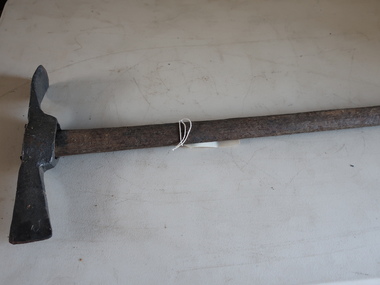
... Miners' picks were commonly used in the nineteenth...' picks were commonly used in the nineteenth and early twentieth ...Miners' picks were commonly used in the nineteenth and early twentieth century for extracting gold from underground mine tunnels.Found in the Harrietville area. Similar to those used in the nearby Kiewa Valley where prospecting for gold was also an occupation.Formerly KV 071. Handmade - of steel with a wooden handle. It was used to break up rock and ore, making it easier to extract valuable minerals. The pointed end of the pickaxe was used to chip away at rock, while the flat end was used to strike the rock for breaking it apart. This one has a long handle.gold mining, miners' pick -
 Buninyong & District Historical Society
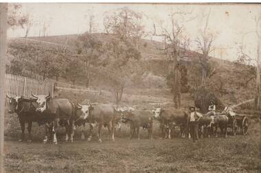
Photograph - B/W photograph, Copy of photograph of a bullock team at Mt. Noorat
... of transporting supplies across Victoria in the nineteenth and early... of transporting supplies across Victoria in the nineteenth and early ...The bullock train would have been a typical means of transporting supplies across Victoria in the nineteenth and early twentieth centuryThis image was taken by J.W.H. Austin, the well-known photographer of Durham Lead from approximately 1870 who documented typical scenes of rural Victoria in the late 1800s.Copy of photograph of a bullock team at Mt. NooratBullock team at Mt. Noorat c.1899transport, j.w.h. austin, photographers, bullock train -
 Orbost & District Historical Society
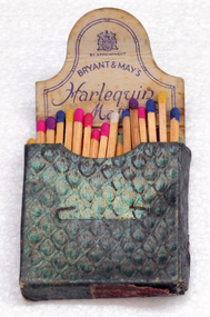
match box and matches, mid 20th century
... -nineteenth century specifically to make matches. Their original...-nineteenth century specifically to make matches. Their original ...These matches are safety matches, which can be struck only against a specially prepared surface. They were made by Bryant and May which was a United Kingdom company created in the mid-nineteenth century specifically to make matches. Their original Bryant and May Factory was located in Bow, London. They later opened other match factories in the United Kingdom and Australia, such as the Bryant and May Factory, Melbourne, and owned match factories in other parts of the world. These matches belonged to Marjorie Burton.Marjorie Burton ( nee Whiteman), born 12 June, in Birmingham, England came to Orbost in 1995. In England she did office work – typing, shorthand and secretarial work - in accountants’ offices and also trained as a comptometrist with Burroughs in London. She came from a middle-class, working, church-going family. Her mother was a milliner who made many of Marjorie’s clothes, hats and outfits. Marjorie was married in 1938 to a salesman who later became a mechanic in the R.A.F. A box of harlequin matches. The box is a shiny green colour and closes with a tongue into a slit. There is a striking plate underneath. Inside there are approximately 40 matches with various coloured headsInside the lid - Bryant & May's British Made Harlequin Matchesbryant-&-may burton-marjorie matches-harlequin smoking-accessories -
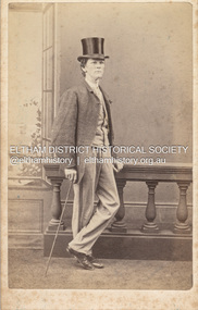 Eltham District Historical Society Inc
Photograph, Charles Rudd, Possibly Samuel Shillinglaw, c.1871
... the nineteenth century, generally measuring two and a half inches by four... the nineteenth century, generally measuring two and a half inches by four ...Samuel Shillinglaw was born at Merri Creek, Victoria, September 27, 1848. He married Agnes McIntosh at Windsor, January 9, 1878 and died at Prahran, September 13, 1925. Photographer Charles Rudd took over from W. Bear on the west side of Chapel Street, Prahan and was in business at this location from 1871-1872 (Sands McDougall Melbourne Directory) A duplicate photo is contained in Album 2 (05664) CARTE-DE-VISITE (cdv) 1857-1890 Cartes-de-visite (cdv's) are the most common form of photograph from the nineteenth century, generally measuring two and a half inches by four and an eighth inches (6.3 x 10.5 cm) when mounted, sepia toned, mounted on a card which was generally printed with the photographer's name and address on the back or beneath the portrait. - Frost, Lenore; Dating Family Photos 1850-1920; Valiant Press Pty. Ltd., Berwick, Victoria 1991marg ball collection, shillinglaw family photo album 1, 1871, 1871-1872, c. rudd & co photographers chapel street prahran, samuel shillinglaw (1848-1925)