Showing 1342 items
matching north park
-
 Greensborough Historical Society
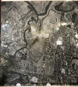
Aerial Photograph, Yan Yean M/S 7922 Run 17 No. 3833-18, 1/11/1984
Covers Viewbank area: North boundary Martin's Lane; South boundary Yarra River & Birrarung Park; East boundary east of Plenty RiverLaminated black and white aerial photograph; adjoins 6227 on west sideviewbank -
 Greensborough Historical Society
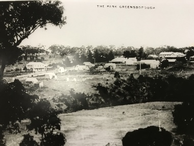
Photograph, The Park Greensborough, 1900c
View of Greensborough Park from Partington's Hill, showing sporting ground, Plenty River, Marble Hall, sparse housing on north side of Main Road, the Farmers' Arms hotel, the Rechabite Hall and Main Road bridge over the the railway line. Marble Hall is the double-storied building on the corner of Main Road.Part of a collection of 5 enlarged photographs dating from the early 1900s.Black and white enlargement of photographgreensborough park, main street greensborough, rechabite hall, farmers' arms hotel, marble hall, greensborough railway -
 Greensborough Historical Society
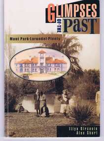
Book, Glimpses of the past: Mont Park, Larundel, Plenty. By Iliya Bircanin and Alex Short, 1909o
The psychiatric hospitals at Mont Park, Larundel and Plenty closed in the late 1970s and this book gives a brief history of the group of hospitals. The area has since been redeveloped into a residential area, although some of the original buildings remain.This book gives an outline of life within the hospital precinct.64 pages, illus. (some col.). Cover includes sepia photo 'Pond at Farm Worker's Block circa 1927'.mont park hospital, larundel hospital, plenty hospital, iliya bircanin, alex short, nemps, north eastern metropolitan psychiatric services -
 Greensborough Historical Society
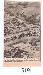
Newspaper clipping, Greensborough shopping centre 1970, 1970_
The photograph is of the centre of Greensborough in 1970, prior to the Greensborough Plaza being built. The Partington farm house, named 'Alwyn' (after Alan and Wyn Partington) can be seen north of the Railway Line. Alan and Wyn had to leave this farm in 1976 - moving to a new house - built by son Gary - at 54 Manatunga Circuit - to make way for the creation of Whatmough Park and development of the Hailes Street-The Circuit-Greensborough Plaza precinct.This is an important visual record of Greensborough before the redevelopment of the late 1970's. It also shows the Whatmough park area when it was still the Partington family farm.A black and white newspaper clipping featuring an aerial photograph.Nilgreensborough streets, greensborough, aerial photograph, 1970, partington, whatmough park, greensborough swimming pool -
 Greensborough Historical Society
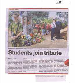
Newspaper Clipping, Students join tribute Watsonia North Primary WN4988, 19/08/2015
Students from many schools in the area laid wreaths to commemorate the Battle of Long Tan during the Vietnam War, including those from Watsonia North Primary.News clipping, black text, colour image.watsonia north primary school, battle of long tan, greensborough war memorial park -
![Photograph - Digital image, Willis Vale [2], 1950c](/media/collectors/4f729f5697f83e03086015b8/items/54fd41442162f10d30bf885f/item-media/54fd41912162f10d30bf8caa/item-fit-380x285.jpg) Greensborough Historical Society
Greensborough Historical SocietyPhotograph - Digital image, Willis Vale [2], 1950c
View of Greensborough in the distance from Willis Vale and surrounding land: House built by Edward Maygar, The flowering Hawthorne Bushes were planted by William Partington. Note the prominent house on upper right where Robert Whatmough lived in the mid 19th century and later sold to Partington family. It was located on the Plenty River across from Partington's Flat. The derelict Willis Vale house was destroyed in 1964 when a fire originating from North Plenty Gorge - Kurrak Road - was lit by two teenage boys and made its way several kilometres down to Partington's Flat Greensborough. In 1946, Alan Partington built the Alwyn Farmhouse in place of the original Robert Whatmough home seen in this photo which became Whatmough Park circa 1976.Home of the Partington familyDigital copy of black and white photograph.willis vale, partington family, maygar family, whatmough -
 Greensborough Historical Society
CD-ROM, Lynne Moore, Binnak Park, 1985-2012
... Series of 69 colour photographs of Binnak Park area... of Binnak Park area, Watsonia North, taken from 1985 to March 2012 ...Series of 69 colour photographs of Binnak Park area, Watsonia North, taken from 1985 to March 2012 by Lynne MooreOne CD-ROM in plastic envelopeBinnak Park 1985- Mar. 2012binnak park, watsonia north -
 Greensborough Historical Society
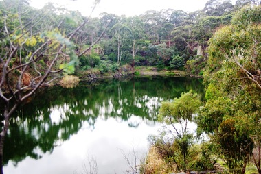
Photograph - Digital image, Marilyn Smith, Blue Lake 1, 19/06/2015
Blue Lake is in Yellow Gum Park in the Plenty Gorge, north of Greensborough.Digital copy of colour photographsyellow gum park, blue lake, plenty gorge park -
 Greensborough Historical Society
Photograph - Digital image, Marilyn Smith, Blue Lake 2, 19/06/2015
Blue Lake is in Yellow Gum Park in the Plenty Gorge, north of Greensborough.Digital copy of colour photographsyellow gum park, blue lake, plenty gorge park -
 Greensborough Historical Society
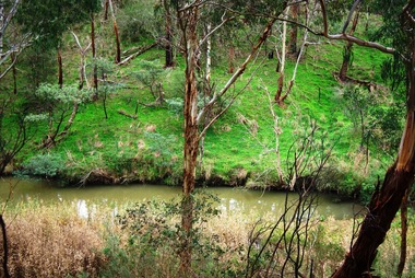
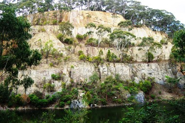
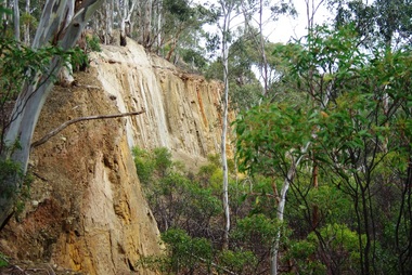
Photograph - Digital image, Marilyn Smith, Blue Lake: the escarpment, 19/06/2015
Blue Lake is in Yellow Gum Park in the Plenty Gorge, north of Greensborough.Digital copy of colour photographsyellow gum park, blue lake, plenty gorge park -
 Greensborough Historical Society
Photograph - Digital image, Marilyn Smith, Blue Lake: Vegetation, 19/06/2015
Blue Lake is in Yellow Gum Park in the Plenty Gorge, north of Greensborough. These photos show the variety of vegetation in the park.Digital copy of colour photographsyellow gum park, blue lake, plenty gorge park -
 Greensborough Historical Society
Photograph - Digital Image, Blue Lake: Views of lake, 19/06/2015
Blue Lake is in Yellow Gum Park in the Plenty Gorge, north of Greensborough. These photos show views of the lake.Digital copy of colour photographsyellow gum park, blue lake, plenty gorge park -
 Greensborough Historical Society
Photograph - Digital image, Marilyn Smith, Blue Lake: More views of the lake, 19/06/2015
Blue Lake is in Yellow Gum Park in the Plenty Gorge, north of Greensborough. These photos show views of the lake.Digital copy of colour photographsyellow gum park, blue lake, plenty gorge park -
 Greensborough Historical Society
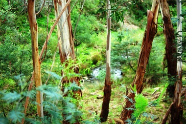
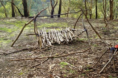
Photograph - Digital image, Marilyn Smith, Blue Lake: Makeshift camp-site, 19/06/2015
Blue Lake is in Yellow Gum Park in the Plenty Gorge, north of Greensborough. These photos show a makeshift camp site in the park.Digital copy of colour photographsyellow gum park, blue lake, plenty gorge park -
 Greensborough Historical Society
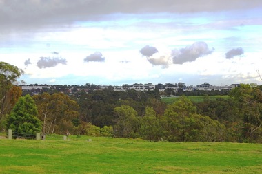
Photograph - Digital image, Marilyn Smith, Blue Lake: Greensborough from Yellow Gum Park, 19/06/2015
Blue Lake is in Yellow Gum Park in the Plenty Gorge, north of Greensborough. This photo was taken from Yellow Gum Park and shows Greensborough in the distance.Digital copy of colour photographsyellow gum park, blue lake, plenty gorge park -
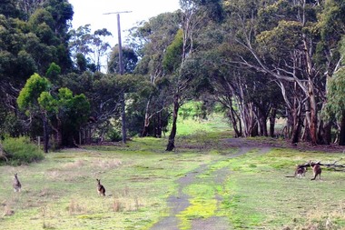 Greensborough Historical Society
Photograph - Digital image, Marilyn Smith, Blue Lake: Kangaroos at Yellow Gum Park, 19/06/2015
Blue Lake is in Yellow Gum Park in the Plenty Gorge, north of Greensborough. These photos show kangaroos in the Park.Digital copy of colour photographsyellow gum park, blue lake, plenty gorge park -
 City of Moorabbin Historical Society (Operating the Box Cottage Museum)
Document - Genealogy Chart Henry Dendy (Photocopy), 19 thC
In 1840 Henry Dendy, a farmer in Surrey, England acquired a "Special Survey" from the Commissioners for Land and Emigration which gave Dendy the right to choose land in Port Phillip for the "bargain basement" price of only £1 per acre for 5120 acres, (an area of 8 square miles). The Special Survey also included the right to "the shipment of a worker for every £20 spent on land, whose free passage was paid by the Crown, equalling a total of 100 workers ". Accordingly Dendy sold his English holdings and paid the required £5120 and arrived in Melbourne in February 1841. However by this time land in the new colony was selling for £5 - £40 per acre. Because Henry Dendy possessed the order from the Colonial Office in London he was able to successfully oppose Super-intendant LaTrobe's attempts to alter the price of the land. Dendy appointed Jonathan Were, (an entrepreneur, who had arrived in 1839), as his Manager and who later became a partner. Together, Dendy and Were decided on an area 5 miles south from Melbourne, bounded by North Road, East Boundary Road, South Road and to the west by Port Phillip Bay. Were and Dendy pitched their tents in the area now known as ' Park St, Brighton' and sank a well near the corner of 'St Andrew's St and Wells St'. By 1845 J.B Were and Company had bought almost half of Dendy's land and Were built himself "Moorabbin House" in Were St Brighton made from stone, quarried from local cliffs. It was still standing in 1924. Legend records Moorabbin is named after the Aboriginal word for ' Mother's Milk ' The soil is very fertile and well supplied with water especially in the area called 'East Brighton' - now known as Bentleigh and East Bentleigh - By 1850 the area had developed with numerous market gardens, dairy farms, fruit gardens and vineyards supplying food for the growing population of Melbourne.In 1840 Henry Dendy, a farmer in Surrey, England acquired a "Special Survey" from the Commissioners for Land and Emigration which gave Dendy the right to choose land in Port Phillip for the price of only £1 per acre for 5120 acres. This land was called Brighton in the Parish of Moorabbin, County of Bourke and emigrants developed the land establishing market gardens , dairy and poultry farms that provided the food for the growing population of Melbourne. A photocopy of the Genealogy Chart of the Dendy Family that Henry Dendy brought with him when he emigrated to Melbourne 1841Genealogy signs and descriptionsdendy henry, dendy's special survey brighton 1841, governor gipps, captain lonsdale, super-intendant latrobe, port phillip, melbourne, new south wales, squatters, emmigrants, county of bourke, parish of moorabbin, early settlers, pioneers, market gardeners, dairy farmers, fruit farms, moorabbin, bentleigh, brighton, cheltenham, were jonathan binn, -
 City of Moorabbin Historical Society (Operating the Box Cottage Museum)
Document, Henry Dendy family Shield
In 1840 Henry Dendy, a farmer in Surrey, England acquired a "Special Survey" from the Commissioners for Land and Emigration which gave Dendy the right to choose land in Port Phillip for the "bargain basement" price of only £1 per acre for 5120 acres, (an area of 8 square miles). The Special Survey also included the right to "the shipment of a worker for every £20 spent on land, whose free passage was paid by the Crown, equalling a total of 100 workers ". Accordingly Dendy sold his English holdings and paid the required £5120 and arrived in Melbourne in February 1841. However by this time land in the new colony was selling for £5 - £40 per acre. Because Henry Dendy possessed the order from the Colonial Office in London he was able to successfully oppose Super-intendant LaTrobe's attempts to alter the price of the land. Dendy appointed Jonathan Were, (an entrepreneur, who had arrived in 1839), as his Manager and who later became a partner. Together, Dendy and Were decided on an area 5 miles south from Melbourne, bounded by North Road, East Boundary Road, South Road and to the west by Port Phillip Bay. Were and Dendy pitched their tents in the area now known as ' Park St, Brighton' and sank a well near the corner of 'St Andrew's St and Wells St'. By 1845 J.B Were and Company had bought almost half of Dendy's land and Were built himself "Moorabbin House" in Were St Brighton made from stone, quarried from local cliffs. It was still standing in 1924. Legend records Moorabbin is named after the Aboriginal word for ' Mother's Milk ' The soil is very fertile and well supplied with water especially in the area called 'East Brighton' - now known as Bentleigh and East Bentleigh - By 1850 the area had developed with numerous market gardens, dairy farms, fruit gardens and vineyards supplying food for the growing population of Melbourne. dendy henry, dendy's special survey brighton 1841, governor gipps, captain lonsdale, super-intendant latrobe, port phillip, melbourne, new south wales, squatters, emmigrants, county of bourke, parish of moorabbin, early settlers, pioneers, market gardeners, dairy farmers, fruit farms, moorabbin, bentleigh, brighton, cheltenham, were jonathan binn, -
 City of Moorabbin Historical Society (Operating the Box Cottage Museum)
Document - Pedigree of Henry Dendy, c1840 Original ; Copy 1985
This is a copy of the document brought by Henry Dendy to the Colony in 1841. In 1840 Henry Dendy, a farmer in Surrey, England acquired a "Special Survey" from the Commissioners for Land and Emigration which gave Dendy the right to choose land in Port Phillip for the "bargain basement" price of only £1 per acre for 5120 acres, (an area of 8 square miles). The Special Survey also included the right to "the shipment of a worker for every £20 spent on land, whose free passage was paid by the Crown, equalling a total of 100 workers ". Accordingly Dendy sold his English holdings and paid the required £5120 and arrived in Melbourne in February 1841. However by this time land in the new colony was selling for £5 - £40 per acre. Because Henry Dendy possessed the order from the Colonial Office in London he was able to successfully oppose Super-intendant LaTrobe's attempts to alter the price of the land. Dendy appointed Jonathan Were, (an entrepreneur, who had arrived in 1839), as his Manager and who later became a partner. Together, Dendy and Were decided on an area 5 miles south from Melbourne, bounded by North Road, East Boundary Road, South Road and to the west by Port Phillip Bay. Were and Dendy pitched their tents in the area now known as ' Park St, Brighton' and sank a well near the corner of 'St Andrew's St and Wells St'. By 1845 J.B Were and Company had bought almost half of Dendy's land and Were built himself "Moorabbin House" in Were St Brighton made from stone, quarried from local cliffs. It was still standing in 1924. Legend records Moorabbin is named after the Aboriginal word for ' Mother's Milk ' The soil is very fertile and well supplied with water especially in the area called 'East Brighton' - now known as Bentleigh and East Bentleigh - By 1850 the area had developed with numerous market gardens, dairy farms, fruit gardens and vineyards supplying food for the growing population of Melbourne. A copy of a paper chart of the Pedigree of Henry Dendy in a wooden frame with glassPedigree / of the branch of the family / DENDY moorabbin, brighton, henry dend special survey 1841 y, early settlers, pioneers, market gardeners -
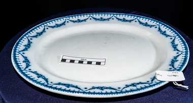 City of Moorabbin Historical Society (Operating the Box Cottage Museum)
Kitchen Equipment, meat platter 'CETEM WARE', c1930
The Maling Pottery of Newcastle upon Tyne, England, was in production from 1762 to 1963. In its heyday it claimed to be the biggest pottery in the world. The first Maling pottery was established at North Hylton, near Sunderland, in 1762 by William Maling. William’s descendants who moved to the Newcastle area and built a succession of larger works. The last of these – the Ford B pottery – was begun in 1878 and occupied a 14 acre site... Maling’s stock in trade was everyday white ware – marmalade jars for Keillers and Coopers, crockery for railways, shipping lines and hotels, and a huge variety of domestic kitchenware. With a significant export trade in the 1920s they had showrooms in Australia, New Zealand and Denmark. Mary Ford, daughter of an Edinburgh glass manufacturer, married Christopher Maling. Christopher Thompson Maling’s initials form one of the company’s early factory marks – the letters CTM inscribed vertically inside a triangle. The Maling name (which had first appeared with the castle mark in the 1920s) and extended to the trade name “Cetem Ware” when the company adopted its well known trademark of a castle in the early years of this century. The “Cetem” name continued to be used into the 1930s. the Maling name continued to be used as a trademark until the factory finally closed in 1963 The outbreak of World War 11 in 1939 marked the beginning of a long decline. Many of the factory’s workers were called up for military service, and wartime restrictions prevented decorative ware being produced for the home market.A larger oval china platter with blue garland around the rim ‘ CETEM WARE’ EMPIRE c1930 On base ; CETEM WARE / over a Castle / EMPIRE / Rd No 519757 china, pottery, cetem ware, maling pottery co ltd., maling william, maling christopher thompson, ford mary, newcastle upon tyne uk, crockery, north hylton sunderland uk, moorabbin, bentleigh, market gardeners, early settlers, cheltenham, world war 11 1939-45, cooking -
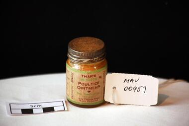 City of Moorabbin Historical Society (Operating the Box Cottage Museum)
Manufactured Glass, 'Thars' ointment, mid 20th C
A poultice is a soft moist mass, often heated and medicated, that is spread on cloth over the skin to treat an aching, inflamed, or painful part of the body. It can be used on wounds such as cuts, inflammations like boils and to draw out splinters.A clear glass jar with a metal screw top containing 'Thar's' antiseptic poultice ointment.Front THAR'S / ANTISEPTIC / POULTICE / OINTMENT / Thar Chemical Co. / Pty. Ltd. / 74-76 Victoria Street / North Richmond / Left Side WAR-TIME PACK / FOR ......... Right Side DIRECTIONS ....... / Vertically sides Purifying, Soothing / Antiseptic, Healing pharmacy, medicines, thars ointment, thar chemical company, hospitals, nursing, containers, moorabbin, richmond, bentleigh, cheltenham, melbourne, poultices, medical poultices -
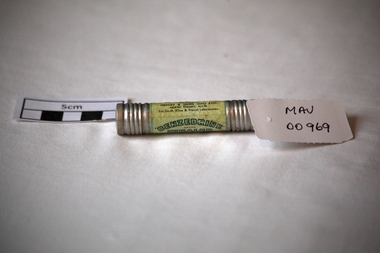 City of Moorabbin Historical Society (Operating the Box Cottage Museum)
Containers, metal cylindar 'Benzedrine ' inhaler, mid 20thC
An Inhaler helps to ease breathing and provides relief from a stuffy nose caused by colds and allergies. An empty metal cylinder with screw top containing ‘Benzedrine’ inhalation’BENZEDRINE’./ BRAND / INHALER / FOR RELIEVING NASAL CONGESTION / Each tube is packed with /……… / Remove both ends , insert tapered /end well into nostril / …….. Effectiveness gradually decreases / with use / ….Distributed by / MENLEY&JAMES (Col) LTD / NORTH SYDNEY N.S.W. / For Smith, Kline & French Laboratories pharmacy, medicines, asthma inhalers, respiratory diseases, early settlers, market gardeners, moorabbin, bentleigh, cheltenham, benzedrine, sydney, new south wales, menley & james (col) ltd., smith, kline & french pty ltd -
 City of Moorabbin Historical Society (Operating the Box Cottage Museum)
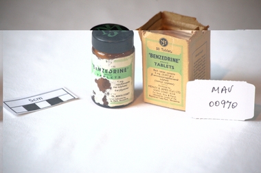
Manufactured glass, bottle 'Benzedrine ' tablets, mid 20thC
Benzedrine was used medically to enlarge nasal and bronchial passages until it was discontinued and replaced with compounds with weaker psychoactive properties (e.g., ephedrine, levomethamphetamine, and propylhexedrine). An empty, clear glass bottle, with a plastic screw top, that contained 'Benzedrine' tablets . Original box.Bottle Front is damaged : 'BENZEDRINE' / BRAND / TABLETS / 5mg ............... Back : POISON.........under / medical supervision. Box Front & Back : MJ / 50 Tablets / 'BENZEDRINE' BRAND / TABLETS / Each tablet contains / 5mg. (0.077gr.) ............./ Distributed by / MENLEY & JAMES (Col) Ltd. / NORTH SYDNEY N.S.W./For Smith, Kine & French / Laboratories, owners of the / registered Trade Mark. 'Benzedrine' Left Side: POISON / It is dangerous / to take this preparation / except under / medical / supervision. Right Side: IMPORTANT / 'Benzedrine ' Brand / Tablets should not / be confused with / 'Benzedrine' Brand Inhaler. ............pharmacy, medicines, asthma, respiratory disease, benzedrine, early settlers, market gardeners, moorabbin, bentleigh, cheltenham, manufactured glass, bottles, menley & james col. ltd., smith, kine & french laboratories -
Glenelg Shire Council Cultural Collection
Photograph - Photograph - Hanlon Park, Portland, n.d
... Black and white photo of a football match at Hanlon Park... Cliff Street Portland great-ocean-road Hanlon Park recreation ...Black and white photo of a football match at Hanlon Park, Portland, taken from north side of ground, looking south. Spectators can be seen behind white boundary fence, some footballers close to fence on that side.Back: Round purple stamp: 'PRINTED BY M.E. ANDREWS, PORTLAND' 'Scene of Football Match Portland V Casterton Federal' 'Attendance 400' - handwritten in black inkhanlon park, recreation, football, local sport -
 Halls Gap & Grampians Historical Society
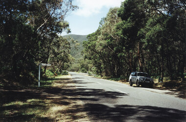
Photograph - Coloured, 1998
Photo shows car parked at side of the road at Wannon Campground, looking north on the Halls Gap - Dunkeld Road.access routes, chalets -
 Eltham District Historical Society Inc
Photograph, Spring Excursion, Hume and Hovell bus tour Stage 2, Seymour, Benalla; 26 Oct 1997, 26/10/1997
MONUMENT HUNTING THE HUME AND HOVELL WAY (Newsletter No. 117, November 1997, by Diana Bassett-Smith) Sunday October 26 1997 dawned bright and very warm. Some twenty-five members, complete with picnic baskets, met outside the Eltham Library awaiting the Cobb and Co. large coach which would be taking us on the second leg of our travels along the route of the early explorers Hume and Hovell. Stephen West was our very good driver for the day. He would be guided around the circuitous route by Russell Yeoman wh9 had made a detailed study, not only of the intended route, but of the story of these two explorers. During the trip Russell regaled us with poetry, quotations from the Journals and the History of the Shire of Seymour, "The New Crossing Place: by Martindale, 1982, (now Mitchell Shire due to the recent amalgamations). We headed towards the Hume Highway via Greensborough and Cooper Street and proceeded north to our first stop, noting on the way Monument Hill in the distance which is near Kilmore and, according to Russell, well worth the effort to visit as the view across the valley is magnificent. Past Sunday Creek Valley, Mt Piper and Mt Disappointment, all traversed and noted and named by them. We passed through Tallarook, then onto Seymour where we took photos of the monument telling us that Hume and Hovell had passed through on the 28th of October 1824. We also deviated down Hume and Hovell Road viewing deer and emu farming and the Bellbourie property now a sanctuary. Leaving Seymour behind we travelled up the Avenel Road to the Avenel monument, pyramidal in design of four reducing square blocks with a sharply pointed peak, erected in 1924 in memory of the 1824 exploration. The day was warming up and the countryside showing the dryness of the current drought. A parallel note had been made in their journal too of 1824 of the drought appearance of the country they were traversing. At Seven Creeks, Euroa we stopped for some minutes to check the monument placed 20th November 1924 to commemorate their passage on the 29th December 1824. More photos. Russell had pointed out the abrupt termination of the distant ranges which is noted in their journal. The next monument is beside the road at the entrance to Honey Suckle Creek Caravan Park, Violet Town. The squarish shaped monument some eight feet high is topped with a simple steel cross, and was to mark the date of 28th December 1824 and built for the 20th November 1924. By now it was 12.20 and nearly lunchtime as we drove along the Warranbayne Road to Roach's Road, monument hunting without success. Though there is a large, what appears to be an old timber sign which was hard to read, maybe this was the lost monument. In many of the paddocks hay had been cut and baled or was being cut, what a contrast to the rugged country they had passed through which was smoky from the fires of the natives burning off By 1.00 pm we were at Benalla and pulled up beside the park where abundant beds of roses filled the air with their scent and the smell of barbecued food twitched the nostrils whilst the cheerful sounds of other picnickers could be heard throughout the park. We left the bus and collected up our picnics, dispersed to the various tables and enjoyed the shade from the various European trees. 2.00 pm and we were on the road again driving along the Benalla, Mansfield, Yea road. The Swanpool monument states that they passed four miles south and returned three miles north. Then we stopped at the Barjarg monument which notes that they camped near this spot. It is again a pyramidal monument and this time topped with a steel arrow indicating their route of the 29th November 1824. Half an hour later we came to another monument, again with a steel arrow marker on top and the plaque dated the 2nd of 12th 1824. Erected on the 12th of 12th 1924. "They blazed the way that we might inherit the land." Another square based and needle topped monument appeared at Yarck near Yea and this plaque records the date of 3 December 1824. Near McGuigans Road Russell related that the expedition had lost a dog but it had found them next day, the dog was apparently torn by a kangaroo. A short while later Russell reminded us here of the problems they encountered in crossing the Goulburn River near Molesworth where banks were high, water deep and wide. "Good coat of grass but quite dry due to drought". At Yea we stopped for afternoon tea and raided the last of our picnics and looked at the monument to their journey of 1824, situated at a corner of the gardens near the bowling green. No photo – we were out of film. We returned home via Kinglake West and Whittlesea past the Yan Yean Reservoir, not full. 5.00 pm back at Eltham we emptied out of the bus and everyone, including Joan Cole, collected their things, Joan also had the major souvenir of the day, a large carp she had picked up from the river bank, her cat was in for a great feast. The day was made so interesting by the informed commentary which Russell provided. His background knowledge of the route and nature of the journey could only have come from many hours of reading and driving the area. Thank you to Russell and to everyone who made the day so informative and pleasurable. Diana Bassett-Smith. Record of the Society's history of activities - Spring 1997 excursionRoll of 35mm colour negative film, 6 stripsFuji 200shire of eltham historical society, activities, pretty hill, seymour, benalla, hume and hovell, monuments -
 Eltham District Historical Society Inc
Photograph, Spring Excursion, Hume and Hovell bus tour Stage 2, Seymour, Benalla; 26 Oct 1997, 26/10/1997
MONUMENT HUNTING THE HUME AND HOVELL WAY (Newsletter No. 117, November 1997, by Diana Bassett-Smith) Sunday October 26 1997 dawned bright and very warm. Some twenty-five members, complete with picnic baskets, met outside the Eltham Library awaiting the Cobb and Co. large coach which would be taking us on the second leg of our travels along the route of the early explorers Hume and Hovell. Stephen West was our very good driver for the day. He would be guided around the circuitous route by Russell Yeoman wh9 had made a detailed study, not only of the intended route, but of the story of these two explorers. During the trip Russell regaled us with poetry, quotations from the Journals and the History of the Shire of Seymour, "The New Crossing Place: by Martindale, 1982, (now Mitchell Shire due to the recent amalgamations). We headed towards the Hume Highway via Greensborough and Cooper Street and proceeded north to our first stop, noting on the way Monument Hill in the distance which is near Kilmore and, according to Russell, well worth the effort to visit as the view across the valley is magnificent. Past Sunday Creek Valley, Mt Piper and Mt Disappointment, all traversed and noted and named by them. We passed through Tallarook, then onto Seymour where we took photos of the monument telling us that Hume and Hovell had passed through on the 28th of October 1824. We also deviated down Hume and Hovell Road viewing deer and emu farming and the Bellbourie property now a sanctuary. Leaving Seymour behind we travelled up the Avenel Road to the Avenel monument, pyramidal in design of four reducing square blocks with a sharply pointed peak, erected in 1924 in memory of the 1824 exploration. The day was warming up and the countryside showing the dryness of the current drought. A parallel note had been made in their journal too of 1824 of the drought appearance of the country they were traversing. At Seven Creeks, Euroa we stopped for some minutes to check the monument placed 20th November 1924 to commemorate their passage on the 29th December 1824. More photos. Russell had pointed out the abrupt termination of the distant ranges which is noted in their journal. The next monument is beside the road at the entrance to Honey Suckle Creek Caravan Park, Violet Town. The squarish shaped monument some eight feet high is topped with a simple steel cross, and was to mark the date of 28th December 1824 and built for the 20th November 1924. By now it was 12.20 and nearly lunchtime as we drove along the Warranbayne Road to Roach's Road, monument hunting without success. Though there is a large, what appears to be an old timber sign which was hard to read, maybe this was the lost monument. In many of the paddocks hay had been cut and baled or was being cut, what a contrast to the rugged country they had passed through which was smoky from the fires of the natives burning off By 1.00 pm we were at Benalla and pulled up beside the park where abundant beds of roses filled the air with their scent and the smell of barbecued food twitched the nostrils whilst the cheerful sounds of other picnickers could be heard throughout the park. We left the bus and collected up our picnics, dispersed to the various tables and enjoyed the shade from the various European trees. 2.00 pm and we were on the road again driving along the Benalla, Mansfield, Yea road. The Swanpool monument states that they passed four miles south and returned three miles north. Then we stopped at the Barjarg monument which notes that they camped near this spot. It is again a pyramidal monument and this time topped with a steel arrow indicating their route of the 29th November 1824. Half an hour later we came to another monument, again with a steel arrow marker on top and the plaque dated the 2nd of 12th 1824. Erected on the 12th of 12th 1924. "They blazed the way that we might inherit the land." Another square based and needle topped monument appeared at Yarck near Yea and this plaque records the date of 3 December 1824. Near McGuigans Road Russell related that the expedition had lost a dog but it had found them next day, the dog was apparently torn by a kangaroo. A short while later Russell reminded us here of the problems they encountered in crossing the Goulburn River near Molesworth where banks were high, water deep and wide. "Good coat of grass but quite dry due to drought". At Yea we stopped for afternoon tea and raided the last of our picnics and looked at the monument to their journey of 1824, situated at a corner of the gardens near the bowling green. No photo – we were out of film. We returned home via Kinglake West and Whittlesea past the Yan Yean Reservoir, not full. 5.00 pm back at Eltham we emptied out of the bus and everyone, including Joan Cole, collected their things, Joan also had the major souvenir of the day, a large carp she had picked up from the river bank, her cat was in for a great feast. The day was made so interesting by the informed commentary which Russell provided. His background knowledge of the route and nature of the journey could only have come from many hours of reading and driving the area. Thank you to Russell and to everyone who made the day so informative and pleasurable. Diana Bassett-Smith. Record of the Society's history of activities - Spring 1997 excursionRoll of 35mm colour negative film, 6 stripsFuji 200shire of eltham historical society, activities, pretty hill, seymour, benalla, hume and hovell, monuments