Showing 7670 items
matching road building
-
 Eltham District Historical Society Inc
Photograph, Jim Connor, Avenue of Honour, Main Road, Eltham, 14 Jan 2017
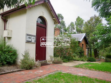
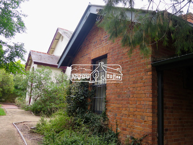
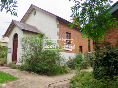
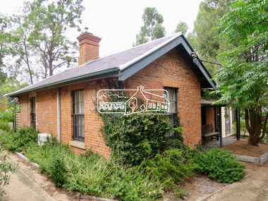
... the former Eltham Courthouse (1860) at 730 Main Road, the oldest... the former Eltham Courthouse (1860) at 730 Main Road, the oldest ...Eltham Gateway, Eltham Justice Precinct featuring the former Eltham Courthouse (1860) at 730 Main Road, the oldest public building in the shire and the former Police Residence (1859) at 728 Main Road, Eltham - now part of the Local History Centre and home to Eltham District Historical SocietyTomorrow's history documented todayeltham, jim connor collection, main road, eltham gateway, eltham courthouse, eltham justice precinct, local history centre, police residence, avenue of honour -
 Eltham District Historical Society Inc
Photograph, Jim Connor, Avenue of Honour, Main Road, Eltham, 14 Jan 2017
... the former Eltham Courthouse (1860) at 730 Main Road, the oldest... the former Eltham Courthouse (1860) at 730 Main Road, the oldest ...Eltham Gateway, Eltham Justice Precinct featuring the former Eltham Courthouse (1860) at 730 Main Road, the oldest public building in the shire and the former Police Residence (1859) at 728 Main Road, Eltham - now part of the Local History Centre and home to Eltham District Historical SocietyTomorrow's history documented todayeltham, jim connor collection, main road, eltham gateway, eltham courthouse, eltham justice precinct, local history centre, police residence, avenue of honour -
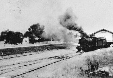 Kiewa Valley Historical Society
Photographs – Set of 3 black and white photographs of a building being transported by steam train
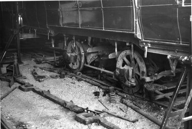
... , all heavy road stock including building materials, farm... to the sealing of the Kiewa Valley Highway in 1950, all heavy road stock ...Prior to the sealing of the Kiewa Valley Highway in 1950, all heavy road stock including building materials, farm equipment and other heavy machinery had to be transported via railway lines to either Albury, Wodonga or Bright and then transported overland for the remainder of the distance by wagon on rough, poorly made roads. Trains also services the mining industries of the Ovens Valley and the transportation of tourists to Mount Buffalo and the very popular Mount Buffalo Chalet.Steam trains were a major form of transport for rural community members prior to the introduction of road transport. Local producers including farmers relied on rail transport to send and receive essential building equipment, farming produce, materials, stock and mail to maintain their lifestyles and social connections with the outside world. 3 black and white photographs of a building being transported by steam train. Photos show the train in three progressively closer photos. Photo shows a man standing in the doorway at the controls of the train, 3 figures, possibly children leaning out of the window of the carriage and another man, standing on the tracks with hands on hips. Photo could have been taken in Tallangatta, Cudgewa or Ebden near Lake Hume where trains were a major form of transport prior to the 1950’s. No markingstransportables; steam train; railway;, old tallangatta, esther temple -
 Bendigo Historical Society Inc.
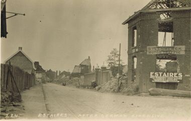
Postcard - ACC LOCK COLLECTION: ESTAIRES AFTER GERMAN OFFENSIVE, POST, 1914-1918
... offensive. Damaged/ruined buildings on sides of road. Two signs... buildings on sides of road. Two signs on building at right ...Postcard, WW1, B&W image of Estaires after a German offensive. Damaged/ruined buildings on sides of road. Two signs on building at right - 'Steenwerck Motor Traffic' and 'Estaires'. The latter has two arrows pointing in opposite directions to other towns. Copy Z 24 See also Copy 1401.73postcard, postcard, ww1, france, estaires, ruins -
 Bendigo Historical Society Inc.
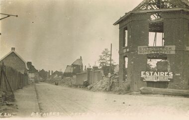
Postcard - ACC LOCK COLLECTION: ESTAIRES AFTER GERMAN OFFENSIVE, POSTCARD, 1914-1918
... offensive. Damaged/ruined buildings on sides of road. Two signs... offensive. Damaged/ruined buildings on sides of road. Two signs ...Postcard, WW1, B&W image of Estaires after a German offensive. Damaged/ruined buildings on sides of road. Two signs on building at right - 'Steenwerck Motor Traffic' and 'Estaires'. The latter has two arrows pointing in opposite directions to other towns. Copy Z 24 See also Copy 1401.108postcard -
 Otway Districts Historical Society
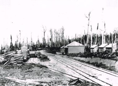
Photograph, Beech Forest Railway Station, 1903, 1903
... Railway Station was the terminus, already 3 roads wide... Forest great-ocean-road In 1903, before the extension to Crowes ...In 1903, before the extension to Crowes, Beech Forest Railway Station was the terminus, already 3 roads wide with Station building, outshed, Goods Shed, and three small departmental residences. An NQR wagon near the Goods Shed is loading timber while a further NQR wagon sits outside the station building.Photograph, B/W, 174mm x 267mm. Beech Forest Railway Station, 1903.beech forest; railways; station; -
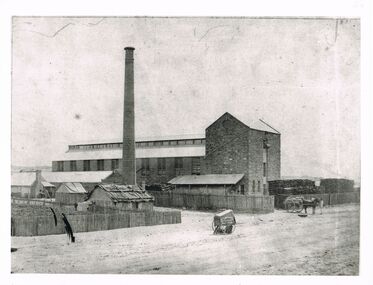 Bendigo Historical Society Inc.
Photograph - WES HARRY COLLECTION: STONE INDUSTRIAL BUILDING, CHIMNEY
... roof hut on road adjoining large building , various smaller...industrial stone building Batchelder Batchelder Black ...Black and white photo, image: large stone industrial building, brick chimney, stacks of wood. Man standing on top floor operating winch. Horse and wagon beneath, loaded with bags of ( could be wheat ? ) On LH side of image, picket fence surrounds large amount of cut wood - cut to equal length. Slab and bark roof hut on road adjoining large building , various smaller buildings to back of hut. Batchelder carriage in centre of image. Batchelderindustrial stone building, batchelder -
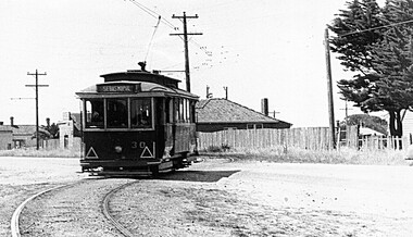 Ballarat Tramway Museum
Photograph - Digital image, Late 1950's
... - in particular the road surface and the buildings. Photo 1950's or early... in the late 1950's, in particular the road surface and the buildings ...Yields information the appearance and details about No. 30 and the Albert St road crossing in the late 1950's, in particular the road surface and the buildings.Digital scan from the Ben Parle collection of SEC No. 30 crossing Albert St Sebastopol, with the destination of Sebastopol - in particular the road surface and the buildings. Photo 1950's or early 1960 prior to introduction of dash canopy lighting. Has the houses either side of the street in view. Photo received with the Ben Parle slides 09/2004. trams, tramways, sebastopol, albert st, tram 30 -
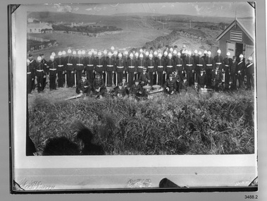 Flagstaff Hill Maritime Museum and Village
Photograph - Military
... GENERAL painted on the door. There is a road and some buildings.... There is a road and some buildings on the left, another road on the right ...Photograph; black and White group photograph of the Volunteer Corps and Band in dress uniform with white pith helmets, the the band members wearing caps. Band instruments are in the foreground on the ground. There is a hut on the right with the word GENERAL painted on the door. There is a road and some buildings on the left, another road on the right with tall posts, and hills in the background. One of the instruments is a Rope Tensioned Bass Drum. 3488.1 is unmounted, and has two stamps on the back 3488.2 is a copy of a mounted photograph, with impressed inscriptions below Painted on the building "GENERAL" (3488.1) Stamp, purple ink; "Flagstaff Hill Maritime Village" (3488.2) Impressed below the copy and photographed with the copy: Coat of Arms in centre [Lion and Unicorn], pulse impressed script on the left and impressed text on the right.flagstaff hill, warrnambool, shipwrecked-coast, flagstaff-hill, flagstaff-hill-maritime-museum, maritime-museum, shipwreck-coast, flagstaff-hill-maritime-village, photograph, volunteer corps band -
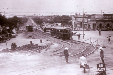 Melbourne Tram Museum
Slide, Melbourne & Metropolitan Tramways Board (MMTB), c1926
... Kilda Road. Has W 366 (St Kilda Beach) on the temporary or new...Melbourne Tram Museum 8 Wallen Road Hawthorn melbourne ...35mm colour slide TMSV copy slide of trackwork at St Kilda Junction, possibly soon after a change over to the new track in St Kilda Road. Has W 366 (St Kilda Beach) on the temporary or new track pending the construction of a road surface and the link to Wellington St. Photo may be from a photo held in the Public Records Office series. On the corner of Punt and St Kilda Road is s building advertising Schweppes Junction Motor service station."MP 30" in pencil on the side.trams, tramways, st kilda junction, trackwork, new tramways, w class, road works, tram 366 -
 Melbourne Tram Museum
Postcard, Rose Stereograph Co, "Melbourne from the Air", early 1940s
... Kilda Road. The building in the middle bottom of the photo...Melbourne Tram Museum 8 Wallen Road Hawthorn melbourne Rose ...Rose Series postcard No. P 622, titled ""Melbourne from the Air", Photo looking east over Melbourne with the Melbourne skyline, railway yards, St Kilda Road, Yarra River and Princes Bridge in the view. Three trams can be seen in the view in St Kilda Road. The building in the middle bottom of the photo is the recently completed Australian Provincial Assurance (APA) Assocation Limited Head Office on the south east corner of Collins and Queen Streets. This 1889 building was refaced and the tower added in 1928-1929. The adding of three additional floors to the Bank of Australasia building, 1875-1876, is well in hand 1929-1931 on the north west corner of Queen and Collins Streets. On the south east corner of the corner of Collins and Market Streets, the new Australian Mutual Provident (AMP) Society Head Office is reaching full height, also constructed 1929-1931. Yields information about an aerial view of Melbourne C1930Postcard - printed real photograph with Rose Stereograph Co. name on the rear.tramways, trams, aerial views, melbourne, collins st. -
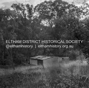 Eltham District Historical Society Inc
Negative - Photograph, J.A. McDonald, Road Reserve Housing, Mar. 1961
... Shack built on road reserve without permit Most probably up... Tree Road, Hurstbridge. At times, Building Surveyor George E ...Shack built on road reserve without permit Most probably up on Simms Road, Kinglake Other areas where illegal shacks were built wer at the junction of Flat Rock Road and Cherry Tree Road, Hurstbridge. At times, Building Surveyor George E Newton would have to attend to these shacks for inspection and issue demolition ordersRecord of various Shire of Eltham infrastructure works undertaken during the period of 1952-1962 involving bridge and road reconstruction projects, sometimes with Eltham Shire Council Project Reference numbers quoted. It was during this period that a number of significant improvements were made to roads and new bridges constructed within the shire that remain in place as of present day (2022). In many situations, the photos provide a tangible visible record of infrastructure that existed throughout the early days of the Shire. The album was put together by or under the direction of the Shire Engineer, J.A. McDonald.infrastructure, shire of eltham, 1961-03, building surveyor, cherry tree road, flat rock road, george e. newton, houses, hurstbridge, kinglake, road reserve, road reserve housing, scan - 120 format 6x6 negative, shack, simms road -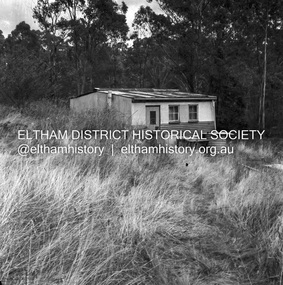
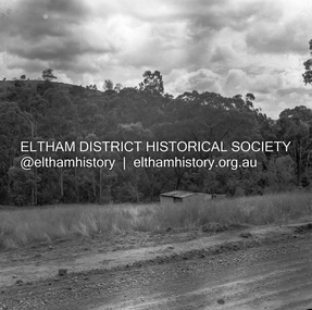 Eltham District Historical Society Inc
Negative - Photograph, J.A. McDonald, Road Reserve Housing, Mar. 1961
... Shack built on road reserve without permit Most probably up... Tree Road, Hurstbridge. At times, Building Surveyor George E ...Shack built on road reserve without permit Most probably up on Simms Road, Kinglake Other areas where illegal shacks were built were at the junction of Flat Rock Road and Cherry Tree Road, Hurstbridge. At times, Building Surveyor George E Newton would have to attend to these shacks for inspection and issue demolition ordersRecord of various Shire of Eltham infrastructure works undertaken during the period of 1952-1962 involving bridge and road reconstruction projects, sometimes with Eltham Shire Council Project Reference numbers quoted. It was during this period that a number of significant improvements were made to roads and new bridges constructed within the shire that remain in place as of present day (2022). In many situations, the photos provide a tangible visible record of infrastructure that existed throughout the early days of the Shire. The album was put together by or under the direction of the Shire Engineer, J.A. McDonald.infrastructure, shire of eltham, 1961-03, building surveyor, cherry tree road, flat rock road, george e. newton, houses, hurstbridge, kinglake, road reserve, road reserve housing, scan - 120 format 6x6 negative, shack, simms road -
 Port Melbourne Historical & Preservation Society
Map - MMBW Map Area No 56, after 1911
... Street and Williamstown Road including an A T Harmon building... Street and Williamstown Road including an A T Harmon building ...The map is based on the 1894 MMBW map (Cat No 271) but shows buildings that were constructed after this date. In particular houses in Bridge Street between Williamstown Road and Derham Street, buildings between the right of way and Derham Street and Williamstown Road including an A T Harmon building constructed in 1911. There are also houses at the top end of Derham Street near Williamstown Road.Photocopy of a section of a larger MMBW map created after 1911.engineering - board of works, built environment, alfred thomas harmon -
 Ballarat Tramway Museum
Photograph - Black & White Photograph/s, Richard Gilbert, 1975
... has been lifted on No. 2 road within the depot building... side frame. The tram car has been lifted on No. 2 road within ...Black and White photograph of BTPS No. 26 lifted while its side frame was being replaced during 1975. Photo printed in the August 1975 issue of Trolley Wire on page 32. Photo shows the broken side frame and the replacement side frame. The tram car has been lifted on No. 2 road within the depot building. Photo by Richard Gilbert. tramways, trams, btps, depot, tram equipment, tram 26 -
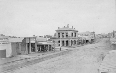 Stawell Historical Society Inc
Photograph, Main Street Stawell looking East with the large two story building being the Post Office 1878
... Main St. looking East. Large two story building... grampians Main St. looking East. Large two story building ...Main St. looking East. Large two story building is the Post Office. 1878. Star Hotel in middle of road on the hill. Buildings from left Brown Produce Merchant, McAlpine Bros Tinsmith Plumbers, J. Porch Draper, Chemist, Stawell Post Office, Akins Seedsman Stationer, Grocer, Herbert Photo Studio's, T. Browns Timber Yard, Star Hotel. Victorian Views. C. Herbert, Photo. Stawell 1878stawell businesses streetscape -
 City of Moorabbin Historical Society (Operating the Box Cottage Museum)
Booklet - Souvenir History of Centre Road, Bentleigh Methodist Church Centenary Celebrations. 9 May - 17 May 1953, 1953
... Methodist Church, Centre Road. The first church building... Church, Centre Road. The first church building on the site ...Methodist Church, Centre Road. The first church building on the site was built of timber in 1850. In 1865, the wooden church building was sold and a new brick church was built, this building was expanded over the years to accomodate an ever increasing congregation. In 1928 the parish opened yet another new brick church - which still stands today (2022). The church is now the Greek Orthodox Parish of "Saints Raphael, Nicholas & Irene".The Methodist Church in Centre Road, Bentleigh was integral to the spiritual well being and social life of the early settlers.Photocopy of Booklet of 9 pages with text and pictures.early settlers, parish of moorabbin, city of moorabbin, county of bourke, shire of moorabbin, market gardeners, centre road, methodist sunday school, bentleigh, religion -
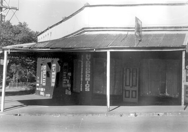 Surrey Hills Historical Society Collection
Photograph, 109 Union Road, Surrey Hills after fire damage
... David Ellis; the Union Road part of the building was occupied... Road Canterbury melbourne This building was damaged by fire ...This building was damaged by fire and was subsequently demolished before June 1983. From 1901-1917 it was the site of the Surrey Hills Post Office. In later years the part of the building with frontage to Windsor Crescent was used as the dental surgery of Dr David Ellis; the Union Road part of the building was occupied by a barber and tobacconist for many years. At the time of the fire the building was used by a business supplying hydroponics requirements. This moved to (?) 119 Highbury Road, Burwood.The image is significant because it documents a building which was an important community facility which no longer exists.Black and white photo of a single-storey corner building with a corrugated iron roofed veranda and a single, 4-panel timber door. There is a sign with '109' mounted on the veranda of the building. There are multiple advertising signs on the walls of the building. Two of the windows are boarded up with corrugated iron sheets.shops, barber shops, tobacconists, surrey hills post office, dentists, union road, windsor crescent, hydroponics supplies, businesses, union road shops, dr david ellis -
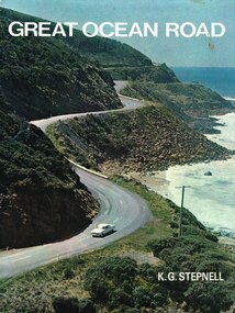 Otway Districts Historical Society
Book, Rigby Limited, Great Ocean Road. K.G. Stepnell, 1972
... servicemen could be given worthwhile employment by building roads... by building roads in isolated areas. The plan was taken up ...The Great Ocean Road may be the only road in the world which was built as a war memorial. In 1916, much of Australia was poorly served by roads, and it was suggested that returning servicemen could be given worthwhile employment by building roads in isolated areas. The plan was taken up for the Great Ocean Road, and work was dedicated to the memory of men who had fallen in World War 1. The road itself is a great feat of engineering. It wind around some of Australia's most rugged coastline. Now it is one of the world's most scenic routes, crossing gorges, along precipitous cliffs, through dense forests, and over steeply rolling coastline country.Great Ocean Road. K.G. Stepnell. 1st ed. Rigby Limited; Adelaide (S.A.); 1972. 36 p.; illus., maps. Hard cover. ISBN 0 85179 371 1great ocean road; roads; fishing; timber; twelve apostles; -
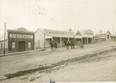
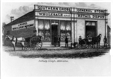 Tarnagulla History Archive
Photographic copy of lithograph: Pierce's Southern Cross Store, Tarnagulla, Pierce's Southern Cross Store, Tarnagulla, circa 1850 to 1871
... , Wholesale and Retail Depot'. In front of building on road are two... transport buildings commercial road main street john pierce southern ...Murray Comrie Collection. John Pierce's Southern Cross General Store, a wholesale grocer and spirit merchant was put up for sale after Pierce's death in 1871. It was later incorporated into the Flour Mill complex. De Gruchy & Leigh was a publishing and printing firm operating in Melbourne and regional Victoria from the late 1850s until the mid 1860s. The company published almanacs and guidebooks as well as prints (portraits, views and genre scenes), maps and architectural plans (Source: National Portrait Gallery, Canberra). This is a copy created from another item in the collection - a printed piece of paper which was either a packing label or receipt form used at the company or a brand label for bottles, perhaps for wine made by the proprietor. Copy probably made by Murray Comrie in the 1970s. Monochrome photographic copy of a lithograph. Depicts a building with glass front windows and signage stating 'J. Pierce Wine & Spirit Merchant' and 'Southern Cross General Store, Wholesale and Retail Depot'. In front of building on road are two horses hitched to carts and men standing on cart and in front of store. This store was located on the south-eastern corner of Commercial Road and King Street. The building was later incorporated into the flour mill complex.tarnagulla, commerce, shops, stores, shopping, food, alcohol, horses, transport, buildings, commercial road, main street, john pierce, southern cross general store -
Bendigo Historical Society Inc.
Document - Former Conrad Heinze Butcher's Shop, 1872
... Valley Road. This building was a weatherboard cottage evidently... Road. This building was a weatherboard cottage evidently built ...Source National Trust: Conrad Heinz Butchers Shop - Happy Valley Road. This building was a weatherboard cottage evidently built in three stages with the front door in the central part, planked by three paned double casements, six-paned sash windows in the rear section; front section and timber veradah with scrolled vallance. The architect and builders are unknown. The outside doors to the cellar and the simple chimney breast remain a notable feature. The original owner was Conrad Heinz a former mayor of Bendigo who with two brothers opened a butcher's shop in the building in 1872. In 1883 he moved to Mt Korong Road Iron Bark, where he carried on another thriving business and built a substantial house close by. When Conrad Heinz left Happy Valley Road, one brother had died, but his widow carried on the first butchering business with the help of a lad and one of her three daughters. The little shop and residence stood for over a century on the spot, almost untouched by modern progress. The shop was closed for 70 years at most. It was demolished about 1982.Data Forms on the house on Corner of Happy Valley Road and Wells Street, Long Gully, now demolished. Various letters to and between the Bendigo Council, the National Trust and the owners of the house.history, national trust bendigo collection, bendigo, happy valley road long gully, butcher's shop bendigo, conrad heinze -
 Glen Eira Historical Society
Photograph - Hawthorn Road, 342, Caulfield
... of a commercial building under construction on Hawthorn Road in September... Road in September 1987. Building is south of Glenhuntly Road ...Two items about this address: 1/Two colour photos of a commercial building under construction on Hawthorn Road in September 1987. Building is south of Glenhuntly Road on western side And was being built for Caulfield City Council. 2/Print of comment entered 03/03/2019 on Victorian Collections website for this file from reader Angus giving street number as '342'. Google map photo print done 04/04/2019 confirms this.hawthorn road, caulfield, caulfield city council, commercial buildings, council buildings -
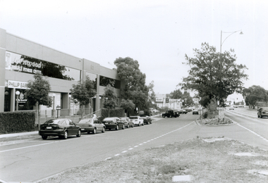 Whitehorse Historical Society Inc.
Photograph, Whitehorse Road looking South, 2000
... of Whitehorse Road looking West wards towards corner of Mitcham Road...Whitehorse Historical Society Inc. 2-10 Deep Creek Road ...Produced as one of a series of 24 prints commissioned by Nunawading & District Historical Society -|Theme: Intersections of Mitcham and Nunawading 2000/2001.|See also Series by P. Simmenauer on the same theme.Black and white photograph - print and negative of Whitehorse Road looking West wards towards corner of Mitcham Road - along service road in Whitehorse Road. From left - right - buildings: Fernwood Female Fitness Centre above offices of Phillip Baressi, Federal Member of Parliament; Hertz Car Rental Yard; Telstra Mobile Shop; Mr. Muffler; Pedders Suspension; Mitcham Hotel. Parallel and angle parking in service road.baressi, phillip, fernwood female fitness centre mitcham, hertz - car rental, telstra, mr muffler, pedders suspension, mitcham hotel -
 The Beechworth Burke Museum
Photograph, 1910
... out plans for new roads and building allotments. Land was sold... out plans for new roads and building allotments. Land was sold ...Taken in 1910, this photograph depicts a scene of Bridge road in Newtown, Beechworth. Walking on the road are two men on horseback, one of which is pulling a carriage with a small dog standing beside it. Behind them are a line of small buildings and shops. Small industries began to expand dramatically in Beechworth, particularly during the 1860s, leading to a strengthening of the towns economy. As early as 1853, areas surrounding the waterway known as Spring Creek were surveyed with the intent of mapping out plans for new roads and building allotments. Land was sold and new buildings were erected, creating an expansion of the Beechworth township and retail services. One building shown in this photograph is Straughair and Duncan's Beechworth Foundry. This business was established in 1858 through the partnership of Mark Straughair and John Duncan. It dealt mostly in the manufacturing of castings and mining machinery, receiving orders from all over the Ovens district. The Business eventually collapsed after the deaths of Straughair in 1882 and Duncan in 1896 but was reopened by W.H. Phillips in 1905. The two other buildings are both associated with the name McKenzie. Evidence suggests that the McKenzie family has a long association with the town of Beechworth. This photograph is historically significant as it provides insight into the nineteenth and twentieth century industrial expansions that happened in the area of Newtown, leading to the urbanisation of Beechworth. Black and white rectangular photograph printed on matte photographic paper mounted on card.Reverse: Newton / 1997.2648 / 33 Newton Beechworth / 84-219-1 / McKenzies / BMM3055 / newtown beechworth, bridge road, 1910, j. duncan, r. mckenzie, m. straughair, industrial growth, ford street, beechworth foundry, straughair and duncan, mckenzie and sons grainstore, mckenzie family store -
![Uniform - School Uniform, Woodbury Ladies’ College [Kew] Badge, circa 1918, c.1918](/media/collectors/550653872162f11fb04854aa/items/5e89f58a21ea671a7c03d0c9/item-media/5e89f65821ea671a7c0508fc/item-fit-380x285.jpg) Kew Historical Society Inc
Kew Historical Society IncUniform - School Uniform, Woodbury Ladies’ College [Kew] Badge, circa 1918, c.1918
... and Cotham Road [the building is still extant as of 2020]. Woodbury... and Cotham Road [the building is still extant as of 2020]. Woodbury ...Woodbury College was an indirect predecessor of Preshil School in Kew. Woodbury College was founded in Glenferrie Road by a Miss Harcourt, former principal of Sydenham College, Moonee Ponds. Miss Harcourt maintained the school until the goodwill was purchased in 1908 by Miss LJ Macey, who had previously operated Lillsden Ladies' College in Edgevale Road, between c.1891 and c.1903. The first school was in a rented building on the south side of Cotham Road between Atkins and Davis Streets. In 1910, a new school building was built on the corner of Uvadale Grove and Cotham Road [the building is still extant as of 2020]. Woodbury College was operated by Miss LJ and Miss HJ Macey until 1920. In 1921, the school amalgamated with the newly formed St Andrew's College, Mont Victor Road, Kew (Vic) under the leadership of Rev JT Lawton [who had previously been principal of St Andrew's School of the 'Pathfinder' in South Yarra]. Miss Macey was for a period the Headmistress of the amalgamated school. Another teacher at the school was Miss Margaret JR Lyttle, who in 1931, left St Andrew's to form the Preshil School.Rare ephemera relating to an early private school in Kew (Vic). The badge was donated by Helen Lade.Brass school badge which includes the initials WL within a large C, surrounded with the school crest - VERITAS VINCIT [Truth Prevails] of Woodbury Ladies College (1903-1920). woodbury college, schools - cotham road - kew - vic, private schools - kew (vic) -
Kew Historical Society Inc
Archive (series) - Subject File, Kew Historical Society, Woodbury Ladies' College, 1986
... Grove and Cotham Road [the building is still extant as of 2020... and Cotham Road [the building is still extant as of 2020]. Woodbury ...Various partiesReference, Research, InformationSecondary Values (KHS Imposed Order)Subject file containing information about Woodbury College, Cotham Road, Kew (Vic). The file includes historically significant primary sources relating to the former Woodbury College [c.1898-1920] and Lillsden Ladies' College, Edgevale Road, Kew (Vic) [c.1891-1903]. In addition to manuscripts, the file also includes photographs and ephemera such as a metal school badge, a hatband and printed programs and school magazines. The file [as of 2020] includes materials donated between 1986 and 2005 by descendants of the second principal (Miss Macey), and by former students and or their descendants. The contents of the reference file include: 1. School origins : undated handwritten manuscript [2pp]; 2. Annual Reports : Handwritten manuscripts for the years 1908, 1909, 1910, 1912, 1913, 1914, 1916, 1917, 1919, 1920 by Miss LJ Macey; 3. Prize List : undated manuscript [3pp]; 4. School Magazine ; undated handwritten manuscripts about the origin of the school's magazine; 5. Woodbury Chat [school magazine] : printed booklets from the years 1918, 1919, 1920 x 2; 6. Correspondence [sundry] : handwritten letters from a parent [1916] and a former pupil (sic) [1938] to Miss Macey; 7. Exercise Books : one containing a handwritten history of the school(s) and the names and addresses of former students and teachers; and the other containing information relating to the National Home Reading Union, Kew Circle [1912-c.1916]. 8. Metal school badge and photographic negative of students. The names of various donors are listed in the file: they include Ann Ransom, Muriel Coghlan, Helen Lade, and Lilian McRae (nee Houston).woodbury college, misses macey, schools - kew (vic), schools - cotham road - kew - vic, private schools - kew (vic), rev jt lawton, cotham road - kew (vic.)woodbury college, misses macey, schools - kew (vic), schools - cotham road - kew - vic, private schools - kew (vic), rev jt lawton, cotham road - kew (vic.) -
![Uniform - School Uniform, Hatband of Woodbury Ladies’ College [Kew], circa 1918, c.1918](/media/collectors/550653872162f11fb04854aa/items/5e254add21ea671e18757914/item-media/5e254b2121ea671e1875b9aa/item-fit-380x285.jpg) Kew Historical Society Inc
Kew Historical Society IncUniform - School Uniform, Hatband of Woodbury Ladies’ College [Kew], circa 1918, c.1918
... and Cotham Road [the building is still extant as of 2020]. Woodbury... and Cotham Road [the building is still extant as of 2020]. Woodbury ...Woodbury College was an indirect predecessor of Preshil School in Kew. Woodbury College was founded in Glenferrie Road by a Miss Harcourt, former principal of Sydenham College, Moonee Ponds. Miss Harcourt maintained the school until the goodwill was purchased in 1908 by Miss LJ Macey, who had previously operated Lillsden Ladies' College in Edgevale Road, between c.1891 and c.1903. The first school was in a rented building on the south side of Cotham Road between Atkins and Davis Streets. In 1910, a new school building was built on the corner of Uvadale Grove and Cotham Road [the building is still extant as of 2020]. Woodbury College was operated by Miss LJ and Miss HJ Macey until 1920. In 1921, the school amalgamated with the newly formed St Andrew's College, Mont Victor Road, Kew (Vic) under the leadership of Rev JT Lawton [who had previously been principal of St Andrew's School of the 'Pathfinder' in South Yarra]. Miss Macey was for a period the Headmistress of the amalgamated school. Another teacher at the school was Miss Margaret JR Lyttle, who in 1931, left St Andrew's to form the Preshil School.Rare ephemera relating to an early private school in Kew (Vic). The hatband was worn by Lilian McCrae in circa 1918 and donated by her sister Heather Houston. The badge was donated by Helen Lade.Navy blue hatband with narrow white and yellow stripes of Woodbury Ladies College (1903-1920). woodbury college, schools - cotham road - kew - vic, private schools - kew (vic)