Showing 11890 items
matching roads - victoria
-
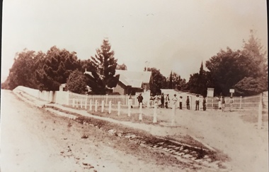
 Surrey Hills Historical Society Collection
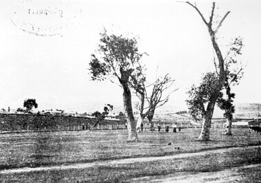
Photograph, Surrey Hills Golf Club - looking towards Doncaster, 1902, 1902
... Road and down Victoria Crescent to where Box Hill TAFE is now... Trafalgar Street, Mont Albert to Whitehorse Road and down Victoria ...Reproduced by permission of Mr John Arnold from his book: "The Riversdale Golf Club - a history, 1892-1977." Copyright to book: Riversdale Golf Club. Surrey Hills Golf Club operated from 1892-1908 then moved and became Riversdale Golf Club. The game was played across paddocks from Trafalgar Street, Mont Albert to Whitehorse Road and down Victoria Crescent to where Box Hill TAFE is now located in Elgar Road. There were problems with cows eating the tee flags! The clubhouse still exists as 30 Trafalgar Street.This image is important for reference to the landscape and vegetation prior to urbanisation.Black and white photo in the foreground of which is a path running diagonally from left to right. Behind are 5 mature trees whose condition is not vigourous (showing signs of die-back). Several figures are beneath the trees, behind which is a post-and-wire fence, paddocks and distant houses. There is the shadow of a stamp in the top LH corner, suggestive of this having been copied from an earlier image.Caption: "Top: Looking towards Doncaster from the links in 1902."sports grounds, surrey hills golf club, riversdale golf club, john arnold -
 Surrey Hills Historical Society Collection
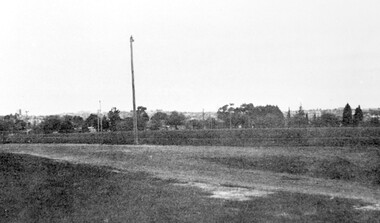
Photograph, Corner of Braemar and Melrose Streets, Box Hill North
... Road and down Victoria Crescent to where Box Hill TAFE is now... Trafalgar Street, Mont Albert to Whitehorse Road and down Victoria ...Reproduced by permission of Mr John Arnold from his book: "The Riversdale Golf Club - a history, 1892-1977." Copyright to book: Riversdale Golf Club. Surrey Hills Golf Club operated from 1892-1908 then moved and became Riversdale Golf Club. The game was played across paddocks from Trafalgar Street, Mont Albert to Whitehorse Road and down Victoria Crescent to where Box Hill TAFE is now located in Elgar Road. There were problems with cows eating the tee flags! The clubhouse still exists as 30 Trafalgar Street.Black and white panoramic photo taken from the corner of Braemar and Melrose Streets, Box Hill North. There is a large area of ground in the front. A fence and hedge traverse the photo in the middle distance in front of which is a tall light pole. Behind the hedge mature trees and houses can be made out.Caption: "Bottom: The same view today taken from the corner of Braemar and Melrose Streets, Box Hill North, or, from the position of the threesome to the left in the above photograph." + in grey lead pencil in Jocelyn Hall's hand (No 290)sports grounds, surrey hills golf club, riversdale golf club, melrose street, braemar street, surrey hills, john arnold -
 Lakes Entrance Historical Society
Photograph - Historic House, 2000
... site in Williams Road. The entrance steps and stonework were... site in Williams Road. The entrance steps and stonework were ...This residence named 'Mourilyan' was built in 1892 beside Harbeck's Store, Lakes Entrance, as a family residence. It was altered and extended in 1927. In 1968 it was relocated to present site in Williams Road. The entrance steps and stonework were constructed by Rev A E Clark. Internal renovations during 1990's. Continually occupied by Harbeck family and descendents. Also a colour photograph of the front entrance of same dwelling in new location at Williams Road, Lakes Entrance. Also one colour photograph of the front entrance of same dwelling in new location at Williams Road Lakes Entrance VictoriaBlack and white photograph of a fibro dwelling on Esplanade, beside Harbecks's Store. Lakes Entrance Victoriahouses, heritage study -
 Whitehorse Historical Society Inc.
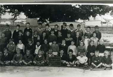
Photograph, Prep - Mitcham Primary - 1940, 1940
... in background at corner of Mitcham Road and Victoria Street. Back row... and stable in background at corner of Mitcham Road and Victoria ...Black and white photograph of Prep grade (Grade 1A) of Mitcham Primary School in 1940. Davin's Dairy and stable in background at corner of Mitcham Road and Victoria Street. Back row - ????Sargeant, David McLean, ???????, John Robertson, Keith Jones, Herb Lilburn, Dave Jones, Jeff Ellis, Alfred Gadsen. 2nd Row - Dawn freeman, Clare Smith, Barbara Savage, Keitha Petty, Marjory Stonehorn, Judith Honeybun, ??????, Pat Flynn, Peggy Burns, Betty Dashwood, Norma Hennessy. 3rd Row - Thelma Burton, Irene Schafer, Robin Leeworthy, Maureen Webster, Barbara Spelling, Margaret Newing, Judith Gorsuch, Lorna Treverton, Valda Hancock, Marion Cumming, ??? Taylor. Front Row - Bill McCaulay, Graham Clements, John Colman, Vernon Osterlind, Arthur Charles, ???? Boyle, Keith Brown, Alan Smith, Micky Dee, Lawrence Petty.mitcham primary school, no. 2904, sargeant, lilburn, herb, jones, keith, robertson, john, mclean, david, dave, ellis, jeff, gadsen, alfred, freeman, dawn, hennesy, norma, dashwood, betty, burns, peggy, flynn, pat, honeybun, judith, stonehorn, marjory, petty, keitha, savage, barbara, burton, thelma, smith, clare, schafer, irene, taylor, cumming, marion, hancock, valda, treverton, lorna, gorsuch, newing, margaret, spelling, webster, maureen, leeworthy, robin, bill mccaulay, fry, lawrence, dee, micky, alan, brown, boyle, charles, arthur, osterlund, vern, colman, clements, graham -
 Kew Historical Society Inc
Plan, Melbourne & Metropolitan Board of Works : Borough of Kew : Detail Plan No.1302, 1910
... stretched, then and now, from Studley Park Road to Victoria Street..., from Studley Park Road to Victoria Street, Richmond ...The Melbourne and Metropolitan Board of Works (MMBW) plans were produced from the 1890s to the 1950s. They were crucial to the design and development of Melbourne's sewerage and drainage system. The plans, at a scale of 40 feet to 1 inch (1:480), provide a detailed historical record of Melbourne streetscapes and environmental features. Each plan covers one or two street blocks (roughly six streets), showing details of buildings, including garden layouts and ownership boundaries, and features such as laneways, drains, bridges, parks, municipal boundaries and other prominent landmarks as they existed at the time each plan was produced. (Source: State Library of Victoria)This plan forms part of a large group of MMBW plans and maps that was donated to the Society by the Mr Poulter, City Engineer of the City of Kew in 1989. Within this collection, thirty-five hand-coloured plans, backed with linen, are of statewide significance as they include annotations that provide details of construction materials used in buildings in the first decade of the 20th century as well as additional information about land ownership and usage. The copies in the Public Record Office Victoria and the State Library of Victoria are monochrome versions which do not denote building materials so that the maps in this collection are invaluable and unique tools for researchers and heritage consultants. A number of the plans are not held in the collection of the State Library of Victoria so they have the additional attribute of rarity.Original survey plan, issued by the MMBW to a contractor with responsibility for constructing sewers in the area identified on the plan within the Borough of Kew. The plan was at some stage hand-coloured, possibly by the contractor, but more likely by officers working in the Engineering Department of the Borough and later Town, then City of Kew. The hand-coloured sections of buildings on the plan were used to denote masonry or brick constructions (pink), weatherboard constructions (yellow), and public buildings (grey). The absence of buildings and or property in Kew facing the Yarra is the most notable feature of this plan. Walmer Street and its bridge stretched, then and now, from Studley Park Road to Victoria Street, Richmond. On the Richmond side of the Yarra, there was evidence in 1904 of industry (‘Wool shed’; Soap Works’) and entertainment (‘Skittle Alley’). In reality, another Plan (No.1303) shows Chinese Gardens bordering the Yarra on the Kew side and buildings in Young Street.melbourne and metropolitan board of works, detail plans, mmbw 1302, cartography -
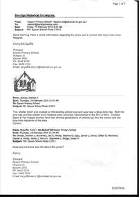
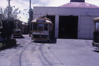 Ballarat Tramway Museum
Slide - 35mm slide/s, Peter Moses, Jan. 1966
... with tram No. 14 on No. 1 road, with destination of "Victoria St... tram depot front with tram No. 14 on No. 1 road ...Photo of Ballarat SEC Wendouree Parade tram depot front with tram No. 14 on No. 1 road, with destination of "Victoria St." and "Trotting Showgrounds Friday Night" auxiliary board on the front of the tram. Note the tram fitted with the white stripe under the dash canopy lights and the use of the large and small numbers of the tram. Kodak cardboard mount slide, taken by Peter Moses January 1966.On back of slide in blue ink "Jan. 1966 / Tram Depot Ballarat No. 14" and bottom right hand corner "P. Moses".tramways, trams, sec depot, tram numbering, depot, wendouree parade, tram 14 -
 Eltham District Historical Society Inc
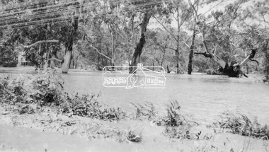
Photograph, Floodwaters, Diamond Creek, Eltham, 1934
... The Diamond Creek in flood near the Main Road bridge... melbourne The Diamond Creek in flood near the Main Road bridge ...The Diamond Creek in flood near the Main Road bridge at Eltham, Victoria. The Yarra also was in flood. In early December 1934 the "Greatest flood in the history of the Yarra" occured, according to The Argus newspaper. Bridges and houses were swept away with hundreds of people left homeless across the state. The historic 1934 flood of the Diamond Creek and Yarra River set the criteria for future planning with respect to flood water rise.This photo forms part of a collection of photographs gathered by the Shire of Eltham for their centenary project book, "Pioneers and Painters: 100 years of the Shire of Eltham" by Alan Marshall (1971). The collection of over 500 images is held in partnership between Eltham District Historical Society and Yarra Plenty Regional Library (Eltham Library) and is now formally known as 'The Shire of Eltham Pioneers Photograph Collection.' It is significant in being the first community sourced collection representing the places and people of the Shire's first one hundred years.Digital image 4 x 5 inch B&W Neg (2 frames on one neg) 9 x 15.5 cm B&W printflooding, eltham, shire of eltham pioneers photograph collection, sepp, diamond creek (river), floods, 1934 flood, diamond creek -
 Kew Historical Society Inc
Photograph - Entrance to Boroondara General Cemetery
... an unusual triangular reserve bounded by High Street, Park Hill Road... triangular reserve bounded by High Street, Park Hill Road ...Boroondara Cemetery, established in 1858, is within an unusual triangular reserve bounded by High Street, Park Hill Road and Victoria Park, Kew. The caretaker's lodge and administrative office (1860 designed by Charles Vickers, additions, 1866-1899 by Albert Purchas) form a picturesque two-storey brick structure with a slate roof and clock tower. A rotunda or shelter (1890, Albert Purchas) is located in the centre of the cemetery: this has an octagonal hipped roof with fish scale slates and a decorative brick base with a tessellated floor and timber seating. The cemetery is surrounded by a 2.7 metre high ornamental red brick wall (1895-96, Albert Purchas) with some sections of vertical iron palisades between brick pillars. Albert Purchas was a prominent Melbourne architect who was the Secretary of the Melbourne General Cemetery from 1852 to 1907 and Chairman of the Boroondara Cemetery Board of Trustees from 1867 to 1909. He made a significant contribution to the design of the Boroondara Cemetery. (Source: Heritage Victoria)This photograph is one of the earliest known photographs of the cemetery, showing the early plantings and fences.Later print copy of an undated original photographic positive of the entrance to the Boroondara General (Kew) Cemetery. The Cemetery had been opened in 1855. This view is from Bulleen Road (now High Street) showing a group of 12 or 13 men standing in a line outside the entrance. At this time, the clocktower and high brick fence had not been constructed, but the trees have reached a substantial heightPencil inscription on reverse - "Boroondara Cemetery Entrance 1862"boroondara general (kew) cemetery, cemeteries -- melbourne (vic.) -
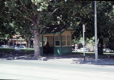 Melbourne Tram Museum
Slide - Set of 15 - Railway MMTB Tram shelters, Robert Green, 2/1990
... - Cnr St Kilda Road and Bromby St 11 - Victoria and Brunswick... Kilda Road and Bromby St 11 - Victoria and Brunswick Streets 12 ...Set of 15 colour slides of Tramway Board and MMTB tramway shelters, by Robert Green Feb1990. 1 - Macarthur St and St Andrews Place (Tramway Board) 2 - Macarthur St and St Andrews Place (Tramway Board) 2A - Macarthur St and St Andrews Place (Tramway Board) - logon on the shelter 3 - SW Corner of St Kilda Road & High St 4 - Cnr St Kilda Road and Dorcas St 5 - Batman Ave and St Kilda Road - removed with Batman Ave closed, now at the TMSV Bylands 6 - ditto 7 - ditto - shows the Bundy clock on the office wall. 8 - Victoria and Brunswick Streets 9 - ditto 10 - Cnr St Kilda Road and Bromby St 11 - Victoria and Brunswick Streets 12 - Cnr Dandenong Road and Wattletree Road 13 - Victoria and Brunswick Streets 14 - Bourke and Spencer Streets - note the Bundy clock. Behind is the MTOCo Offices and Carlyons Hotel.Yields information about Melbourne tramway shelters.Set of 14 Kodak colour slides in plastic mounts and one unmounted phtographAll slides have their location marked on them in black ink.tramways, shelters, tramway board, mmtb, macarthur st, st kilda road, brunwick st, batman ave, victoria parade, wattletree road, bourke st -
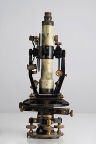 City of Greater Bendigo - Civic Collection
Instrument - Theodolite, E. R. Watts & Sons, c 1930
... on the back of Road Users' Association of Victoria letterhead note... adjustments to the Theodolite written on the back of Road Users ...Theodolites are a highly accurate instrument that measures angles between designated visible points in the horizontal and vertical planes. The theodolite has a long history, with the term first found in 1571 in a surveying textbook 'A geometric practice named Pantometria' by Leonard Digges. (source https://en.wikipedia.org/wiki/Theodolite). Theodolites are used by surveyors as part of their everyday work and although there is no specific information regarding the provenance of this particular one it is assumed it was used locally by the Shire of Marong and / or the Lands Department. Edwin Watts started the company in 1856, trading up to 1920s as E.R. Watts & Son with E. R. Watts & Son Ltd amalgamating with Adam Hilger Ltd to form Hilger & Watts in 1948.0442.1 A black and grey theodolite no 39161 made by Watts & Sons. Various moving parts showing signs of extensive use particularly on the uprights on the main body and around knobs and dials where the paint is worn back to brass. Is housed in original box with key, oil container and pin. 0442.2 handwritten instructions for making adjustments to the Theodolite written on the back of Road Users' Association of Victoria letterhead note paper.Watts & Sons / London / 5974 For N H Seward / Melbournelands and survey department bendigo, shire of marong -
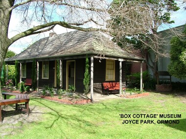 City of Moorabbin Historical Society (Operating the Box Cottage Museum)
Photograph - ' Box Cottage' Reconstruction, c1841
... the original pioneer cottage site, in Joyce Park, Jasper Road, Ormond... Park, Jasper Road, Ormond, Victoria. The museum has copies ...The original small, pioneer cottage was built in the late 1840s to early1850s, by an unknown pioneer. It was located on part of a 30 Acre allotment that was originally part of Henry Dendy’s Special Survey granted in 1841. The doors and window sashes, (made of red deal joinery timber), as well as the brass locks and fittings, are from the original cottage, and were imported from England.The fire-place bricks are from the original cottage, and are sun-dried, (not kiln fired), and are hand-made. Convict marks can be seen on two bricks.There is a small display of external cladding shingles from the original pioneer cottage. These shingles were hand-split, and most likely made from locally collected timber The nails included in this display were used to fasten the shingles on the original cottage, and are also hand-made. The enamel nameplate, “Colonial”, on the wall of the cottage, was the name chosen for the original pioneer cottage when a later owner, Mr August Rietman and wife Frieda leased the property in around 1917. August purchased the property 1935 for 1200 Pounds approximately and resided there until 1953. In 1974 Mr Lewis, a timber specialist, found the dilapidated building on property he had recently purchased in Jasper Rd and suggested it be reconstructed and relocated. Moorabbin Council agreed and the Cottage was rebuilt just about 250 metres from its original site. The cost of the rebuild was met by 'Victoria's 150th Committee, plus a small grant from the City of Moorabbin, and Mr Laurie Lewis donated much of the timber for the reconstruction. Although 'Box Cottage' is a re-construction, it is an unique museum that, being located in the midst of a modern community in Ormond Victoria, can educate and demonstrate many aspects of the early settler’s way of life in Victoria. As such, it is an invaluable resource for students and all kinds of visitors. The original small, pioneer cottage was built in the late 1840s to1850s, by an unknown pioneer. It was located on part of a 30 Acre allotment that was originally part of Dendy’s Special Survey granted in 1841. The re-constructed pioneer cottage, named ‘Box Cottage’, is located only a matter of metres from the original pioneer cottage site, in Joyce Park, Jasper Road, Ormond, Victoria. The museum has copies of interesting Land Titles associated with the surrounding land, including the site of the original pioneer cottage, from Dendy’s time, and into the 1900s. ‘Box Cottage’ is named after the pioneers, William and Elizabeth Box, who resided in the original cottage from approximately 1865, until Elizabeth’s death in 1914.The re-constructed cottage plan has followed faithfully the original dimensions, and plan of the original pioneer cottage, and as many original items from that cottage’s long occupation have been incorporated. Convict marks on sun -dried, fire-place chimney bricks. Enamel nameplate 'Colonial' circa1915brighton, moorabbin, cottages, pioneers, ormond, colonial, mckinnon, dendy henry, box william, box elizabeth, convicts, rietman august, rietman frieda, rietman stefanie -
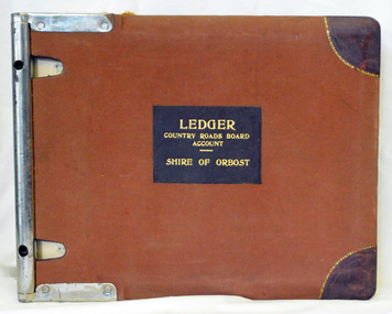
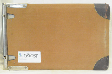
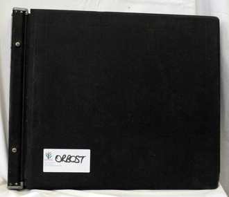 Orbost & District Historical Society
ledger, late 1950's - 1970's
... roads in Victoria between 1913 and 1983. It was succeeded... roads in Victoria between 1913 and 1983. It was succeeded ...This ledger was used by the Shire of Orbost in the late 1950's - 1970's.The item was donated to Orbost & District Historical society from P.R.O.V. as a Place of Deposit (POD) item for safe keeping by a local history group or museum. The shire covered an area of 9,347 square kilometres and existed from 1892 until 1994 when it became part of the East Gippsland Shire Council. Orbost was at first included in the Bairnsdale Shire from 1882 and was later part of the Tambo Shire. Because of travelling distances the Croajingalong Shire was created in 1892 (name changed to Orbost Shire 17.2.1893 with James Cameron as the first Shire President. In 1994 it amalgamated to become part of East Gippsland Shire Council. The Country Roads Board was the government authority for the construction and maintenance of main roads in Victoria between 1913 and 1983. It was succeeded by the Road Construction authority on 1 July 1983 and later merged with the Road Traffic Authority on July 1 1989 to form the Roads Corporation. James Cameron, an Orbost farming pioneer and Member of the Legislative Assembly, fathered the Country Roads Board This item is a hand-written record of Orbost Shire Council accounts. It pre- dates computer records. The Shire of Orbost local council no longer exists having been absorbed by the East Gippsland Shire Council.A black ledger with wooden covers. It contains hand-written records of transactions between Orbost Shire Council and the Country Roads Board.bottom left corner - Orbost in black on a white East Gippsland Shire logoledger accounts shire-of-orbost country-roads-board -
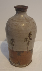 Ballarat Heritage Services
Photograph - Australian Studio Pottery, Ceramic Bottle by Maldon Pottery
... - ) on Barringhup Road, Maldon, Victoria. Tom Metcalf and Graham Masters...- ) on Barringhup Road, Maldon, Victoria. Tom Metcalf and Graham Masters ...Maldon Pottery was established in 1973 by Neville Wilson (1946-1996), Tom Metcalf (1948- ) and Graham Masters (1950- ) on Barringhup Road, Maldon, Victoria. Tom Metcalf and Graham Masters Masters graduated from Bendigo College of Advanced Education all Bendigo graduates. Wilson ) He was a skilled drawer and did all the brushwork. Metcalf (1948- ) graduated in 1968, did two years' work experience at Non-porite in Melbourne, then worked as a thrower and decorator at Bendigo Pottery from 1971-73. He is T.M. on Epsom ware. Masters (1950- ) graduated in 1973 and established the Enterprise Pottery at Myers Flat with Morris Hesse in 1974, so must have joined the partnership later than the others. He left in 1984 to set up his own Sweenies Creek Pottery. Metcalf left in the late 1980s, leaving Wilson to operate the pottery by himself until his death in 1996. As well as using the Maldon Pottery stamp, Wilson signed some of his work with his name or an impressed 'N'. Photograph of a hand thrown ceramic bottle, with glaze design depicting an Australian landscape in the 'continuous trees' pattern.maldon pottery, ceramics, australian studio pottery -
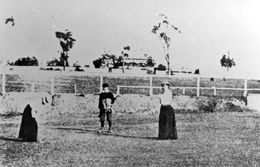 Surrey Hills Historical Society Collection
Photograph, Surrey Hills Golf Club eighth hole, 1902, 1902
... Road and down Victoria Crescent to where Box Hill TAFE is now... Trafalgar Street, Mont Albert to Whitehorse Road and down Victoria ...Reproduced by permission of Mr John Arnold from his book: "The Riversdale Golf Club - a history, 1892-1977." Copyright to book: Riversdale Golf Club. Surrey Hills Golf Club operated from 1892-1908 then moved and became Riversdale Golf Club. The game was played across paddocks from Trafalgar Street, Mont Albert to Whitehorse Road and down Victoria Crescent to where Box Hill TAFE is now located in Elgar Road. There were problems with cows eating the tee flags! The clubhouse still exists as 30 Trafalgar Street. No 3 Beatty Street is in the background. The players are probably standing on what is now Zetland Road.This image is important not only for documentation of early sporting activities in the area but also for evidence of the pre-urban appearance of the landscape.Black and white photo with 2 ladies with golf clubs in the foreground and a lad (? caddy) with a golf bag under his arm. He is wearing a cap and 'plus fours'. The ladies are wearing long skirts, blouses and hats. Behind is a post-and-rail fence with a house and trees in the background.Caption: " Bottom: Putting out on the eighth hole, 1902."sports grounds, surrey hills golf club, riversdale golf club, clothing and dress, zetland road, surrey hills, john arnold -
 Eltham District Historical Society Inc
Negative - Photograph, Floodwaters, Diamond Creek, Eltham, 1934
... The Diamond Creek in flood near the Main Road bridge... melbourne The Diamond Creek in flood near the Main Road bridge ...The Diamond Creek in flood near the Main Road bridge at Eltham, Victoria. The Yarra also was in flood. In early December 1934 the "Greatest flood in the history of the Yarra" occured, according to The Argus newspaper. Bridges and houses were swept away with hundreds of people left homeless across the state. The historic 1934 flood of the Diamond Creek and Yarra River set the criteria for future planning with respect to flood water rise. Noted on reverse of print - Copied by Hugh Fisher, 82 Lygon St., BrunswickThis photo forms part of a collection of photographs gathered by the Shire of Eltham for their centenary project book,"Pioneers and Painters: 100 years of the Shire of Eltham" by Alan Marshall (1971). The collection of over 500 images is held in partnership between Eltham District Historical Society and Yarra Plenty Regional Library (Eltham Library) and is now formally known as the 'The Shire of Eltham Pioneers Photograph Collection.' It is significant in being the first community sourced collection representing the places and people of the Shire's first one hundred years.Digital image 4 x 5 inch B&W Neg (2 frames on one neg) Print 9 x 15.5 cmOn reverse of print - "Copied by Hugh Fisher, 82 Lygon St., Brunswick" (for Shire of Eltham)sepp, shire of eltham pioneers photograph collection, eltham, floods, 1934 flood, diamond creek (creek), floodwater -
 Bendigo Military Museum
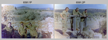
Photograph - 4th Field Survey Squadron Adventurous Training, Unknown Location, SA, 1994
... was in the Grampians region of Victoria. Off-road driver training and abseiling... was in the Grampians region of Victoria. Off-road driver training and abseiling ...This is a set of 31 photographs of 4th Field Survey Squadron undergoing adventurous training held at unknown locations in South Australia, in 1994. It is also possible the training was in the Grampians region of Victoria. Off-road driver training and abseiling were key activities of this adventurous training as well as teamwork, leadership, and field craft. Elements from units of the Army Reserve may have participated in the training. See items 6562.33P, 6563.33P and 6564.28P for more photos taken during this training activity.This is a set of 31 photographs of 4th Field Survey Squadron personnel undergoing adventurous training held at unknown locations in South Australia in 1994. The colour photographs are on 35mm negative film and are part of the Army Survey Regiment’s Collection. The photographs were scanned at 96 dpi. .1) - Photo, colour, 1994. Old ruins. L to R: SGT Steve McGuiness, SPR Chris Pearse, SPR Mark Linwood. .2) - Photo, colour, 1994. Old ruins. L to R: CPL Steve Wegener, SPR Mark Linwood. SGT Steve McGuiness. .3) - Photo, colour, 1994. Old grave. SPR Mark Linwood. .4) to .7) - Photo, colour, 1994. Driver training. Unidentified personnel. .8) - Photo, colour, 1994. Driver training. CPL Steve Wegener. .9) to .12) - Photo, colour, 1994. Driver training. Unidentified personnel. .13) - Photo, colour, 1994. Driver training and hiking. L to R: SPR Greg Richards, SPR Mark McInerney. .14) - Photo, colour, 1994. Driver training and hiking. L to R: SPR Chris Pearse, WO2 Simon ‘Andy’ Capp. .15) - Photo, colour, 1994. Driver training and hiking. Unidentified personnel. .16) - Photo, colour, 1994. Driver training and hiking. L to R: CPL Steve Wegener, CAPT Rob Gray, unidentified (x2), SPR Chris Pearse, WO2 Simon ‘Andy’ Capp. .17) to .18) - Photo, colour, 1994. Driver training. Unidentified personnel. .19) - Photo, colour, 1994. Driver training and hiking. L to R: WO2 Simon ‘Andy’ Capp, SPR Chris Pearse, CPL Stuart Adrain, SPR Mark McInerney. .20) - Photo, colour, 1994. Driver training and hiking. L to R: CPL Stuart Adrain, unidentified, CAPT Rob Gray, WO2 Simon ‘Andy’ Capp, SPR Chris Pearse, SPR Mark McInerney. .21) - Photo, colour, 1994. Driver training and hiking. Unidentified personnel. .22) - Photo, colour, 1994. Driver training and hiking. L to R: unidentified, CPL Stuart Adrain, SPR Mark McInerney, CAPT Rob Gray, remainder unidentified. .23) - Photo, colour, 1994. Abseiling. L to R: SGT Steve McGuiness, unidentified, CPL Steve Wegener, CPL Stuart Adrain. .24) & .25) - Photo, colour, 1994. Abseiling. WO2 Simon ‘Andy’ Capp. .26) - Photo, colour, 1994. Abseiling. CAPT Rob Gray. .27.) to .31) - Photo, colour, 1994. Abseiling. Unidentified personnel..1P to .31P – There are no personnel identified. ‘1994 ADV TRAINING’ annotated on negatives sleeve.royal australian survey corps, rasvy, 4 fd svy sqn -
 Bendigo Military Museum
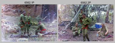
Photograph - 4th Field Survey Squadron Adventurous Training, Unknown Location, SA, 1994
... was in the Grampians region of Victoria. Off-road driver training and abseiling... was in the Grampians region of Victoria. Off-road driver training and abseiling ...This is a set of 33 photographs of 4th Field Survey Squadron undergoing adventurous training held at unknown locations in South Australia, in 1994. It is also possible the training was in the Grampians region of Victoria. Off-road driver training and abseiling were key activities of this adventurous training as well as teamwork, leadership, and field craft. Elements from units of the Army Reserve may have participated in the training. See items 6561.31P, 6563.33P and 6564.28P for more photos taken during this training activity.This is a set of 33 photographs of 4th Field Survey Squadron personnel undergoing adventurous training held at unknown locations in South Australia in 1994. The colour photographs are on 35mm negative film and are part of the Army Survey Regiment’s Collection. The photographs were scanned at 96 dpi. .1) - Photo, colour, 1994. Abseiling. L to R: SGT Steve McGuiness, SPR Chris Pearse, SPR Mark McInerney. .2) - Photo, colour, 1994. Abseiling. L to R: CAPT Rob Gray, SSGT Lynn Johnson, CPL Stuart Adrain, unidentified. .3) - Photo, colour, 1994. Abseiling. Top of cliff. .4) - Photo, colour, 1994. Abseiling. L to R: Mark Linwood, unidentified. .5) - Photo, colour, 1994. Abseiling. Unidentified soldier. .6) - Photo, colour, 1994. Abseiling. Unidentified, WO2 Simon ‘Andy’ Capp. .7) & .8) - Photo, colour, 1994. Abseiling. CPL Steve Wegener. .9) & .10) - Photo, colour, 1994. Abseiling. L to R: SPR Greg Richards, unidentified. .11) - Photo, colour, 1994. Abseiling. SPR Chris Pearse, unidentified (x2). .12) & .13) - Photo, colour, 1994. Abseiling. SPR Mark McInerney. .14) - Photo, colour, 1994. Abseiling. Unidentified personnel. .15) - Photo, colour, 1994. Abseiling. SPR Marc Zehntner. .16) - Photo, colour, 1994. Abseiling. SPR Mark McInerney, unidentified. .17) & .18) - Photo, colour, 1994. Abseiling. CAPT Rob Gray. .19) - Photo, colour, 1994. Abseiling. SGT Steve McGuiness. .20) - Photo, colour, 1994. Abseiling. CPL Steve Wegener. .21) - Photo, colour, 1994. Abseiling. L to R: SPR Greg Richards, unidentified. .22) - Photo, colour, 1994. Abseiling. SPR Greg Richards. .23) to .25) - Photo, colour, 1994. Abseiling. SPR Mark Linwood. .26) - Photo, colour, 1994. Abseiling. L to R: CPL Steve Wegener, CAPT Rob Gray, unidentified. .27) & .28) - Photo, colour, 1994. Abseiling. SSGT Lynn Johnson. .29) - Photo, colour, 1994. Abseiling. SGT Steve McGuiness. .30) - Photo, colour, 1994. Abseiling. Unidentified soldier. .31) - Photo, colour, 1994. Abseiling. SPR Mark McInerney. .32) - Photo, colour, 1994. Abseiling. CAPT Rob Gray. .33) - Photo, colour, 1994. Abseiling. Unidentified soldier..1P to .33P – There are no personnel identified. ‘1994 ADV TRAINING’ annotated on negatives sleeve.royal australian survey corps, rasvy, 4 fd svy sqn -
 Bendigo Military Museum
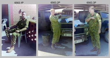
Photograph - 4th Field Survey Squadron Adventurous Training, Unknown Location, SA, 1994
... was in the Grampians region of Victoria. Off-road driver training and abseiling... was in the Grampians region of Victoria. Off-road driver training and abseiling ...This is a set of 33 photographs of 4th Field Survey Squadron undergoing adventurous training held at unknown locations in South Australia, in 1994. It is also possible the training was in the Grampians region of Victoria. Off-road driver training and abseiling were key activities of this adventurous training as well as teamwork, leadership, and field craft. Elements from units of the Army Reserve may have participated in the training. See items 6561.31P, 6562.33P and 6564.28P for more photos taken during this training activity.This is a set of 33 photographs of 4th Field Survey Squadron personnel undergoing adventurous training held at unknown locations in South Australia in 1994. The colour photographs are on 35mm negative film and are part of the Army Survey Regiment’s Collection. The photographs were scanned at 96 dpi. .1) - Photo, colour, 1994. Preparation. LCPL Mitch Oake. .2) - Photo, colour, 1994. Preparation. SPR Chris Pearse. .3) & .4) - Photo, colour, 1994. Preparation. Unidentified soldier. .5) - Photo, colour, 1994. Preparation. SSGT Pat ‘Fuji’ Drover. .6) - Photo, colour, 1994. Preparation. L to R: SGT Steve McGuiness, CPL Steve Wegener, CPL Dick Crawford, CPL Peter Ball, SPR Greg Richards. .7) - Photo, colour, 1994. Preparation. L to R: CPL Peter Ball, SPR Greg Richards. .8) to .10) - Photo, colour, 1994. Preparation. SSGT Lynn Johnson. .11) - Photo, colour, 1994. Social activities. L to R: Unidentified (x8), SPR Chris Pearse, SSGT Lynn Johnson. .12) - Photo, colour, 1994. Social activities. SGT Dave Longbottom. .13) to .15) - Photo, colour, 1994. Social activities. Unidentified personnel. .16) - Photo, colour, 1994. Social activities. L to R: SGT Dave Cook, WO2 Simon ‘Andy’ Capp, CAPT Rob Gray, SPR Chris Pearse, SPR Mark McInerney. .17) to .19) - Photo, colour, 1994. Training area terrain. .20) to .23) - Photo, colour, 1994. Driver training. .24) - Photo, colour, 1994. Training area terrain. .25) - Photo, colour, 1994. Abseiling. SSGT Pat ‘Fuji’ Drover. .26) - Photo, colour, 1994. Abseiling. SGT Mark Donnelly. .27) to .33)- Photo, colour, 1994. Abseiling. Unidentified soldier. .1P to .33P – There are no personnel identified. ‘1994 ADV TRAINING’ annotated on negatives sleeve.royal australian survey corps, rasvy, 4 fd svy sqn -
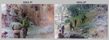 Bendigo Military Museum
Photograph - 4th Field Survey Squadron Adventurous Training, Unknown Location, SA, 1994
... was in the Grampians region of Victoria. Off-road driver training and abseiling... was in the Grampians region of Victoria. Off-road driver training and abseiling ...This is a set of 28 photographs of 4th Field Survey Squadron undergoing adventurous training held at unknown locations in South Australia, in 1994. It is also possible the training was in the Grampians region of Victoria. Off-road driver training and abseiling were key activities of this adventurous training as well as teamwork, leadership, and field craft. Elements from units of the Army Reserve may have participated in the training. See items 6561.31P, 6562.33P and 6563.33P for more photos taken during this training activity.This is a set of 28 photographs of 4th Field Survey Squadron personnel undergoing adventurous training held at unknown locations in South Australia in 1994. The colour photographs are on 35mm negative film and are part of the Army Survey Regiment’s Collection. The photographs were scanned at 96 dpi. .1) - Photo, colour, 1994. Abseiling. Unidentified personnel. .2) - Photo, colour, 1994. Abseiling. L to R: Unidentified (x2), WO2 Ken Talbot-Smith, unidentified, SGT Mark Donnelly, unidentified. .3) to .10) - Photo, colour, 1994. Training area terrain. .11) to .12) - Photo, colour, 1994. Abseiling. Unidentified personnel. .13) to .14) - Photo, colour, 1994. Training area terrain. .15) - Photo, colour, 1994. Training area terrain. L to R: SSGT Brian ‘BC’ Collings, unidentified (x6). .16) - Photo, colour, 1994. Training area terrain. .17) - Photo, colour, 1994. Training area terrain. Unidentified personnel. .18) - Photo, colour, 1994. Training area terrain. L to R: SSGT Brian ‘BC’ Collings, SGT Steve McGuiness. .19) - Photo, colour, 1994. Training area terrain. .20) to .27) - Photo, colour, 1994. Abseiling. Unidentified soldiers. .28) - Photo, colour, 1994. Returning to 4 Fd Svy Sqn. L to R: SPR Fran Calvert, unidentified, SPR Gordon Santo, SPR Matt Arnold, SGT Dave Cook..1P to .28P – There are no personnel identified. ‘1994 ADV TRAINING’ annotated on negatives sleeve.royal australian survey corps, rasvy, 4 fd svy sqn -
 Surrey Hills Historical Society Collection
Photograph, Streetscape near the corner of Victoria Crescent and Hotham Street, Surrey Hills
... from Trafalgar Street, Mont Albert to Whitehorse Road and down... Road and down Victoria Crescent to where Box Hill TAFE is now ...Prior to subdivision for housing this area was paddocks used for grazing of cattle and used as part of the course in the early days of the Surrey Hills Golf Club. Reproduced by permission of Mr John Arnold from his book: "The Riversdale Golf Club - a history, 1892-1977." Copyright to book: Riversdale Golf Club. Surrey Hills Golf Club operated from 1892-1908 then moved and became Riversdale Golf Club. The game was played across paddocks from Trafalgar Street, Mont Albert to Whitehorse Road and down Victoria Crescent to where Box Hill TAFE is now located in Elgar Road. There were problems with cows eating the tee flags! The clubhouse still exists as 30 Trafalgar Street.Black and white photo taken from the centre of a bitumen road which is flanked by bluestone guttering. Nature strips, drive cross-overs and house fences are shown. Trees on the RHS nature strip are pollarded to avoid overhead power and telephone lines. There houses in the background."Bottom: The same view today taken from the intersection of Victoria Crescent and Hotham Street, Surrey Hills."surrey hills golf club, hotham street, victoria crescent, riversdale golf club, surrey hills, john arnold -
 Orbost & District Historical Society
ledger, 1950's -1960's
... for the construction and maintenance of main roads in Victoria between 1913... for the construction and maintenance of main roads in Victoria between 1913 ...This ledger was used bt the Shire of Orbost local government to record Country Roads Board accounts 1950's and 1960's. The item was donated to Orbost & District Historical society from P.R.O.V. as a Place of Deposit (POD) item for safe keeping by a local history group or museum. The shire covered an area of 9,347 square kilometres and existed from 1892 until 1994 when it became part of the East Gippsland Shire Council. Orbost was at first included in the Bairnsdale Shire from 1882 and was later part of the Tambo Shire. Because of travelling distances the Croajingalong Shire was created in 1892 (name changed to Orbost Shire 17.2.1893 with James Cameron as the first Shire President. In 1994 it amalgamated to become part of East Gippsland Shire Council. The Country Roads Board was the government authority for the construction and maintenance of main roads in Victoria between 1913 and 1983. It was succeeded by the Road Construction authority on 1 July 1983 and later merged with the Road Traffic Authority on July 1 1989 to form the Roads Corporation. James Cameron, an Orbost farming pioneer and Member of the Legislative Assembly, fathered the Country Roads Board. This ledger is a hand-written record of accounts for the Orbost Shire local council. It pre-dates computer records. The Orbost Shire Council no longer exists having been absorbed into the East Gippsland Shire Council.A heavy brown coloured ledger with covered wooden covers. it has steel metal binding. Inside are strips of paper marking pages. It contains blue ink hand-written records of monies in/out (?) to Shire of Orbost Council. On the front cover inside a black rectangle in gold print is " LEDGER COUNTRY ROADS BOARD ACCOUNT ORBOST". It is an "Emu Binder".ledger orbost-shire accounts country-roads-board -
 Orbost & District Historical Society
ledger, 1950's ; 1960's
... for the construction and maintenance of main roads in Victoria between 1913... for the construction and maintenance of main roads in Victoria between 1913 ...This ledger was used by the Shire of Orbost to record transactions with the Country Roads board in 1950's and 1960's. The item was donated to Orbost & District Historical society from P.R.O.V. as a Place of Deposit (POD) item for safe keeping by a local history group or museum. The shire covered an area of 9,347 square kilometres and existed from 1892 until 1994 when it became part of the East Gippsland Shire Council. Orbost was at first included in the Bairnsdale Shire from 1882 and was later part of the Tambo Shire. Because of travelling distances the Croajingalong Shire was created in 1892 (name changed to Orbost Shire 17.2.1893 with James Cameron as the first Shire President. In 1994 it amalgamated to become part of East Gippsland Shire Council. The Country Roads Board was the government authority for the construction and maintenance of main roads in Victoria between 1913 and 1983. It was succeeded by the Road Construction authority on 1 July 1983 and later merged with the Road Traffic Authority on July 1 1989 to form the Roads Corporation. James Cameron, an Orbost farming pioneer and Member of the Legislative Assembly, fathered the Country Roads Board. This item is a hand-written record of accounts of the Orbost Shire local Government. It pre-dates computer records,The Shire of Orbost Council no longer exists having been absorbed into th East Gippsland Shire council.A heavy brown coloured ledger with steel bindings. Covers are probably wooden. It contains hand-written records of transactions the Country Roads Board. -
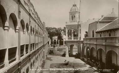 Melbourne Legacy
Postcard, Orange Hotel Oostkant, Soerabaia, Java, c1915
... . W. Elsum. 30 Station Road. North Williamstown. Victoria.... 30 Station Road. North Williamstown. Victoria. Australia ...This postcard has a photo of the Orange Hotel Oostkant, Soerabaia, Java taken around 1915 (now known as Surabaya in Indonesia). Perhaps the sender, Lee, was a returning serviceman from World War One coming back to Australia via Indonesia and this was a card home to his family.A record of postal correspondence in 1915. Postcards were a very common form of communication in the first World War. This type of souvenir would have been familiar to the first Legatees as they had served in World War 1.Glossy postcard with photo of the Orange Hotel in Java.Handwritten: "Dear Katy, Am going to spend a week or so in Java. Hope you are all well. I am feeling very fit, Lee. / Mrs. W. Elsum. 30 Station Road. North Williamstown. Victoria. Australia. " Printed on the photo - 2 / Orange Hotel Oostkant, Soerabaia, Java. / Photo. KURKDJIAN LTD, SOERABAIA.Printed on card - POST CARD / The Address only to be written here Stamp - Nederlandsch-Indie, 5 CENT Postmark - SOERABAJA 16.7.15 souvenir, war correspondence -
 Bendigo Historical Society Inc.
Photograph - EPSOM PRIMARY SCHOOL PHOTOGRAPH
... from 'Kernan Group' 403-405 Mount Alexander Road, Ascot Vale... Alexander Road, Ascot Vale, Victoria 3032. Covering letter dated ...Caption of photograph reads 'Taken at the Epsom School in 1913.' Reverse ditto but includes 20th Dec 1913. Jess 6, Rene 8 1/2 , Dorrie 13 1/2. Mrs J Kane c/o Mrs I Rowe Epsom. Enclosed in envelope addressed to Trevor Parsons postal dated 2010 from 'Kernan Group' 403-405 Mount Alexander Road, Ascot Vale, Victoria 3032. Covering letter dated 19th February 2010 enclosed from Damien Jenkyn to Kerry Mc Guffe principal of Epsom Primary School relating to 'Shelter Shed' pictured in photograph. Photo taken by W.H. Robinsonbendigo, education, epsom primary school -
 Melbourne Tram Museum
Slide - Set of 2, John Webster, 21/07/1959 12:00:00 AM
... , Toorak - Glenferrie Road) in the Victoria St shunting area. Has...Melbourne Tram Museum 8 Wallen Road Hawthorn melbourne ...Set of two Colour slides, Kodak, white cardboard of trams of trams at the Victoria St / Swanston St shunt. 21-7-59. .1 - W2 340 showing East Malvern Darling road opposite the signal box followed by W2 showing route 4. Has a large number of men and school boys at the stop. In the view is a "No Entry" sign. In the background is the Ansett ANA building and a building advertising Havelock Tobacco. The tram has a Pimms No. 1 advert. .2 - W2's 550 (with a Castrol sign), 340 - as above and 358 (route 8, Toorak - Glenferrie Road) in the Victoria St shunting area. Has the Army hall behind the trams.Hand writing on rear in ink; "21-7-59 - KFB2 - TRACK - KEV - Swanston St near Victoria St Melbourne" "21-7-59 - KFB3 - TRACK - KEV - Trams in Victoria St Melbourne" Both slides have the speed and the f reading on the left hand side.trams, tramways, victoria st, swanston st, signal box, route 4, route 8, route 4d, east malvern, tram 550, tram 358, tram 340 -
 Orbost & District Historical Society
book, Broadbent's Melbourne - Sydney Guide Book, 1936
... an active vice-president of the Good Roads Association of Victoria... gippsland Broadbent's Official Road Guides Company took over George ...Broadbent's Official Road Guides Company took over George R. Broadbent's business in 1935. In 1963, it changed its name to Broadbent's Road Maps Pty. Ltd. George Robert Broadbent (1863-1947), cyclist and map publisher, was born on 3 November 1863 at Ashby near Geelong, Victoria. At various times Broadbent held most Victorian and Australian road cycling records. Broadbent became an active vice-president of the Good Roads Association of Victoria in November 1912 and was consulted regularly during the preparation of the country roads bill. That year he took over the Argus motoring column, wrote tirelessly on road improvements and maintenance, and became manager of the Automobile Club's new touring department in 1914.A 160 pp road guide book titled Broadbent's Official Road Guide Melbourne - Sydney. The front cover has a yellow background with a map of the coastline from Sydney to Melbourne, the Prince's Highway route marked. This is inset in a drawing of a car driving along the coastal road.The book contains speedometer readings, route maps, advertisements and photos of points of interest. In the top right is the logo of the Royal Automobile Club of Victoria and at the bottom right is the price 1/-.traavel road-guides broadbent-george car-touring -
 Wodonga & District Historical Society Inc
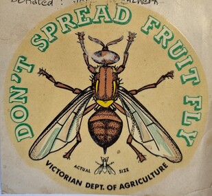
Document - Fruit Fly Border Express Pass, De Neefe Signs Pty. Ltd, c1960
... The permanent fruit fly road blocks in Victoria began... The permanent fruit fly road blocks in Victoria began in 1958. The first ...The permanent fruit fly road blocks in Victoria began in 1958. The first was set up on the Lincoln Causeway between Albury and Wodonga. The aim was to protect the Victorian fruit export industry, the largest in the country. Cars would be stopped and inspected when entering Victoria. At peaks periods, such as Easter and school holidays, there were up to 10 inspectors at the 24 hour checkpoint near the former butter factory on the Lincoln Causeway. Local residents could apply for a pass such as this one which would be displayed on their window, but were still subject to random checks. Hundreds of tonnes of fruit each week was confiscated and pulverised by Department of Agriculture staff. The road block was closed in 1980, partly due to the increased traffic flows and the cost of maintaining inspection points.This image reflects government measures taken to protect the fruit industry in Victoria.A transparent sticker designed to be applied to a car window for motorists to pass through Department of Agriculture fruit fly control points. Instructions for applying the sticker to the window are written on the back of the sticker. It features a large coloured image of a fruit fly as well as a smaller life sized representation of a fruit fly.Around the edge of the circle: "DON'T SPREAD FRUIT FLY/ VICTORIAN DEPT. OF AGRICULTURE? Beside small fruit fly image: "Actual Size"fruit fly control, department of agriculture, fruit fly pass -
 Wodonga & District Historical Society Inc
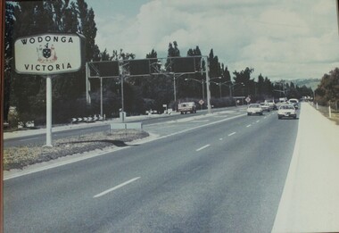
Photograph - Wodonga, Victoria sign and the Fruit Fly check point c1970s
... The permanent fruit fly road blocks in Victoria began... The permanent fruit fly road blocks in Victoria began in 1958. The first ...The permanent fruit fly road blocks in Victoria began in 1958. The first was set up on the Lincoln Causeway between Albury and Wodonga. The aim was to protect the Victorian fruit export industry, the largest in the country. Cars would be stopped and inspected when entering Victoria. At peaks periods, such as Easter and school holidays, there were up to 10 inspectors at the 24 hour checkpoint near the former butter factory on the Lincoln Causeway. Local residents could apply for a pass which would be displayed on their window, but were still subject to random checks. Hundreds of tonnes of fruit each week was confiscated and pulverised by Department of Agriculture staff. The road block was closed in 1980, partly due to the increased traffic flows and the cost of maintaining inspection points.This image reflects government measures taken to protect the fruit industry in Victoria.A large image of the LIncoln Causeway at the Victorian/NSW border at Wodonga. The southbound lanes on the right hand side feature overhead signals and traffic light signs to control traffic leading into the Fruit fly inspection checkpoint ahead. The photo is in a wooden frame.On right hand side: Border sign: Wodonga/Victoria and the Victorian State Coat of Arms.fruit fly control, victoria border, lincoln causeway wodonga -
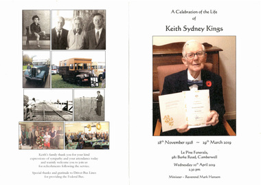 Melbourne Tram Museum
Document - Programme, Le Pine Funerals, "In Memory of Keith Sydney Kings", Apr. 2016
... on the corner of Burke Road and Victoria St Camberwell. .4 - Added 6... held on 10/4/2018 at le Pine on the corner of Burke Road ....1 - Four page - folded A4, heavy card, printed in full colour, Memorial Order of Service for Keith Sydney Kings, featuring a number of photos of Keith. Inside is the Order of Service. NOTE: The date of his birth should have been 12 November 1928. .2 - five A4 sheets, stapled titled "In Memory of Keith Sydney Kings" written by Len Millar for the service. Details Keith's tramway work. .3 - Keith's funeral car was followed by Federal Bus supplied by Driver Bus Lines which Keith and Charles Craig restored. Service held on 10/4/2018 at le Pine on the corner of Burke Road and Victoria St Camberwell. .4 - Added 6/5/2019 - Graeme Rodwell's Eulogy received by email as a word document 4/5/2019. Heading added, font changed to 12 point and page numbers added and saved as a pdf file - see image .5 - AV file - mp4 file of the service - see Reg Item 3458 in AV Files.trams, tramways, funeral, keith kings, buses -
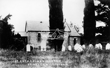 Eltham District Historical Society Inc
Photograph, St. Katherine's Church, St. Helena, Vic
... Located at 277-279 St Helena Road Saint Helena, Victoria... melbourne Located at 277-279 St Helena Road Saint Helena, Victoria ...Located at 277-279 St Helena Road Saint Helena, Victoria. In 1841 Anthony Beale, born on the Island if St Helena took a pastoral lease on the Plenty River where he built a cottage, St Helena, which ultimately gave this area its name. Beale's wife Katherine Rose, nee Young died in 1856 and he erected "The rose Chapel" to her memory. After his death in 1865 the chapel was willed to the Church of England and consecrated in 1876. It was severely damaged by bushfire in 1957. It was fully restored and rededicated in November 1957. The bell calls parishoners to Sunday services is believed to a have come from the Island of St Helena. Source: Mr. A.E. Parsons, Pryor St., Eltham (Mrs. Glasgow - daughter)Statement of Significance Last updated on - October 10, 2005 St Helena's is a rare surviving example of a churchyard cemetery. It is of local historical significance because of its association with the local pioneering family, the Beales, and other notable citizens including Walter Withers and Graham Webster. The cemetery is also the oldest in the municipality, of State significance. The high level of maintenance and the rural ambience contribute to the overall significance of the site. St Katherine's Church building has been reconstructed and is of local historical interest, principally for its value in interpreting the original setting within the Cemetery. It contains stained glass windows of local historical significance, commemorating casualties of the Beale family in World War One. - Victorian Heritage Database This photo forms part of a collection of photographs gathered by the Shire of Eltham for their centenary project book,"Pioneers and Painters: 100 years of the Shire of Eltham" by Alan Marshall (1971). The collection of over 500 images is held in partnership between Eltham District Historical Society and Yarra Plenty Regional Library (Eltham Library) and is now formally known as the 'The Shire of Eltham Pioneers Photograph Collection.' It is significant in being the first community sourced collection representing the places and people of the Shire's first one hundred years.Digital image"St Katharine's Church, St Helena, Victoria"sepp, shire of eltham pioneers photograph collection, other areas, st katherine's church, st helena