Showing 1469 items matching "site no 2"
-
 Halls Gap & Grampians Historical Society
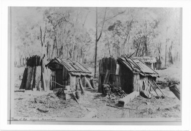
Photograph - B/W, C 1898
... Photo depicts 2 slab huts in foreground and 2 in back right... depicts 2 slab huts in foreground and 2 in back right corner Site ...Photo depicts 2 slab huts in foreground and 2 in back right corner Site of Sony Creek DigginsTwo of the diggers mansions written on frontbuildings, houses, stoney creek -
 Halls Gap & Grampians Historical Society
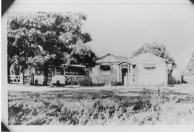
Photograph - B/W, C 1924
Gus Knight bought 2 blocks on the Henham Estate and built his home at tea rooms Unfortunately the estate failed and so after two years he moved the tea rooms to a new site over Mirranatwa Gap to the Wannon CrossingPhoto shows Knight's Tea Rooms at Henham Estatebuildings, shops, knight -
 Ararat & District Historical Society (operating the Langi Morgala Museum)
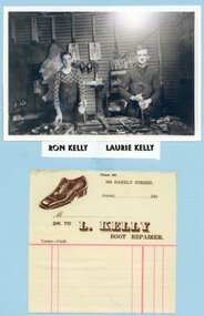
Photograph
L. Kelly Boot Repairer was located at 308 Barkly Street, Ararat, now the current site of Ararat Tyre Power (272 Barkly Street, Ararat). Old site in the early 1940s was Mr H. McMillan Garage for motor repairs. The boot repair section was rented by Laurie Kelly, then 308 Barkly Street. After World War 2 it became home of PMGBlack and white photograph of two men wearing aprons and standing at a work bench with tools. A docket featuring a shoe and a business address for L. Kelly Boot Repairer is beneath the photo.Ron Kelly, Laurie Kelly -
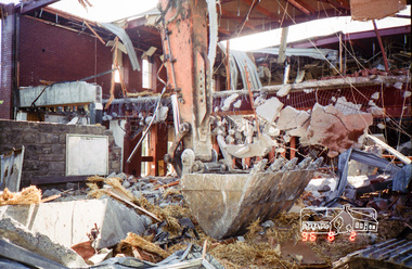
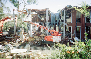
 Eltham District Historical Society Inc
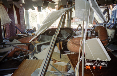
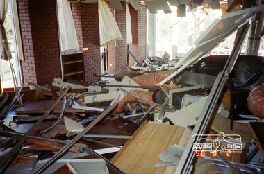
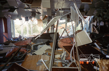
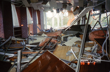
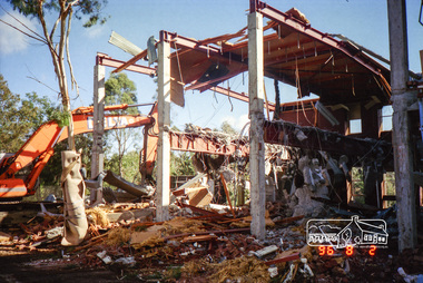
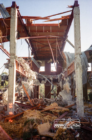
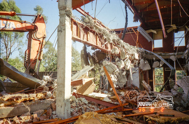
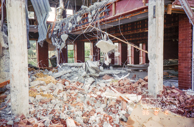
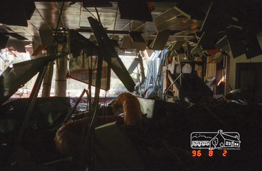
Photograph, Demolition of the former Shire of Eltham building, Main Road, Eltham, 2 Aug 1996, 1996
The Shire of Eltham Office was constructed in the late 1960s on the original site of Shillinglaw Cottage. Upon cessation of the Shire as a local government body following dismissal of councils by the Kennett Liberal Government in December 1994, the new Nillumbik Shire offices were located in Civic Drive, Greensborough. The Shire of Eltham office building was demolished and the site has remained vacant ever since. The three pine trees which featured in front of Shillinglaw Cottage and then the Shire of Eltham Offices remain standing on the vacant site as of 2017. Roll of 35mm colour negative film, 7 stripsKodak Gold 100-5eltham, main road, shire of eltham, shire of eltham office -
 Eltham District Historical Society Inc
Photograph, Demolition of the former Shire of Eltham building, Main Road, Eltham, 2 Aug 1996, 1996
The Shire of Eltham Office was constructed in the late 1960s on the original site of Shillinglaw Cottage. Upon cessation of the Shire as a local government body following dismissal of councils by the Kennett Liberal Government in December 1994, the new Nillumbik Shire offices were located in Civic Drive, Greensborough. The Shire of Eltham office building was demolished and the site has remained vacant ever since. The three pine trees which featured in front of Shillinglaw Cottage and then the Shire of Eltham Offices remain standing on the vacant site as of 2017. Roll of 35mm colour negative film, 7 stripsKodak Gold 100-5eltham, main road, shire of eltham, shire of eltham office -
 Kiewa Valley Historical Society
Black and White photograph of Road Making Machinery, Kiewa Road Making, 25/08/1938
Construction of the main road from South Tawonga to the Bogong High Plains, to provide access to the construction sites for the new Kiewa Hydro Electric Scheme, was commenced early in 1938, the work being undertaken on behalf of the Commission by the Country Roads Board. For the construction work, the Commission purchased three Caterpillar - model R07 - diesel crawler tractors equipped with Kay Brunerei (Brunner) hydraulically operated trailbuilders (angle dozers). This acquisition resulted from a visit to the United States of America in May, 1937 by the Construction Engineer ( Mr. C.H. Kernot) and Assistant Civil Engineer (Mr. J.F. Douglas) where they saw this relatively new type of equipment in use. With the co-operation of the CRB, the Commission demonstrated the operation of these machines at Fishermen's Bend on 6th April, 1938. They were then sent to Kiewa where they commenced operation towards the end of the month. From South Tawonga, the route led immediately across the Western Branch of the Kiewa River necessitating the construction of a bridge 100 feet long. By the end of 1939, the excavation had been 'opened up' for a distance of 19 1/2 miles (approx. 31 km) and of this length, 10 miles (approx. 16 km) had been surfaced.The purchase and use of this type of mechanical equipment in road making was a huge investment, as prior to this most of the work would have been done manually with the use of picks and shovels. Not only were many months of hard manual labour saved, but a very significant amount of time in providing access to the proposed work sites for the new Kiewa Hydro Scheme. This photo is an excellent reminder of how primitive the early machinery was compared to the present but also represents the forward thinking of the State Electricity Commissions engineers in purchasing such innovative equipment . A black and white photograph showing the type of machinery used for road making in the 1930's. It shows a grader being towed by a caterpillar tractor.On the top left hand corner of the photograph , hand written in black ink is the words 'Kiewa Road Making 25/8/1938'. On the right hand side of the photo has been stamped in blue the Number 1. It has been developed on Velox paper (marked on back of photo) with a gloss finish.road making, state electricity commission, caterpillar tractor, kiewa -
 Kiewa Valley Historical Society
Black and White photograph of Road Making Machinery, Kiewa Road Making 25/08/1938 No. 2, 25/08/1938
Construction of the main road from South Tawonga to the Bogong High Plains, to provide access to the construction sites for the new Kiewa Hydro Electric Scheme, was commenced early in 1938, the work being undertaken on behalf of the commission by the Country Roads Board. For the construction work, the Commission purchased three Caterpillar - model R07 - diesel crawler tractors equipped with Kay Brunerei (Brunner) hydraulically operated trailbuilders (angle dozers). This acquisition resulted from a visit to the United States of America in May, 1937 by the Construction Engineer ( Mr. C.H. Kernot) and Assistant Civil Engineer ( Mr. J.F. Douglas) where they saw this relatively new type of equipment in use. With the co-operation of the CRB, the Commission demonstrated the operation of these machines at Fishermen's Bend on 6th April, 1938. They were then sent to Kiewa where they commenced operation towards the end of the month. From South Tawonga, the route let immediately across the Western Branch of the Kiewa River necessitating the construction of a bridge 100 feet long. By the end of 1939, the excavation had been 'opened up' for a distance of 19 1/2 miles (approx. 31 km.) and of this length, 10 miles (approx. 16 km.) had been surfaced. (see KVHS 0328)The purchase of this type of mechanical equipment in road making was a huge investment, as prior to this most of the work would have been done manually with the use of picks and shovels. Not only were many months of hard manual labour saved, but a very significant amount of time in providing access to the proposed work sites for the new Kiewa Hydro Scheme. This photo is an excellent reminder of how primitive the early machinery was compared to the present but also represents the forward thinking of the State Electricity Commissions engineers in purchasing such innovative equipment.A black and white photograph of road making near Mt. Beauty in 1938. Mount Beauty hills can be seen in the background with cleared land for grazing in the fore ground.Hand printed in black ink at the top of the photograph is 'Kiewa Road Making 25/8/1938'. On the right hand corner has been printed the number 2. It has been printed on gloss Velox paper.road making, state electricity commission, caterpillar tractor, kiewa, secv -
 Kiewa Valley Historical Society
Black and White photograph of Road Making Machinery, Kiewa Road Making 25/8/1938(No. 3 in a series of 8), 25/08/1938
Construction of the main road from South Tawonga to the Bogong High Plains, to provide access to the construction sites for the new Kiewa Hydro Electric Scheme, was commenced early in 1938, the work being undertaken on behalf of the Commission by the Country Roads Board. For the construction work, the Commission purchased three Caterpillar - model R07 - diesel crawler tractors equipped with Kay Brunerei (Brunner) hydraulically operated trail builders (angle dozers)). This acquisition resulted from a visit to the United States of America in May, 1937 by the Construction Engineer ( Mr. C.H. Kernot) and Assistant Civil Engineer (Mr. J.F. Douglas) where they saw this relatively new type of equipment in use. With the co-operation of the CRB, the Commission demonstrated the operation of these machines at Fishermen's Bend on 6th April, 1938. They were then sent to Kiewa where they commenced operation towards the end of the month. From South Tawonga, the route led immediately across the Western Branch of the Kiewa River necessitating the construction of a bridge 100 feet long. By the end of 1939,the excavation had been 'opened up' for a distance of 19 1/2 miles (approx. 31 km.) and of this length, 10 miles (approx. 16 km) had been surfaced.The purchase and use of this type of mechanical equipment in road making was a huge investment, as prior to this most of the work would have been done manually with the use of picks and shovels. Not only were many months of hard manual labour saved, but a very significant amount of time in providing access to the proposed work sites for the new Kiewa Hydro Scheme. This photo is an excellent reminder of how primitive the early machinery was compared to the present but also represents the forward thinking of the State Electricity Commission's Engineers in purchasing such new and innovative equipment.A black and white photograph of a Caterpillar diesel crawler tractor and a hydraulically operated trailbuilder (angle dozer) making a road in the Mt. Beauty area.Hand written in black ink in the top left hand corner are the words "Kiewa Road Making 25/8/1938". On the upper right hand of the photograph has been stamped the number 3. On the back is stamped the word 'Velox' severaly times, which is the make of the photograhic paper. roadmaking, caterpillar tractor, kiewa, state electricity commission -
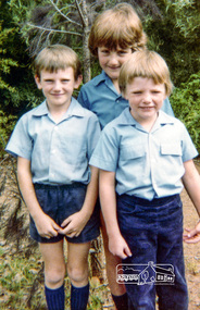 Eltham District Historical Society Inc
Photograph, Grade 2: Peter Whalley, David Prentice (back), Christopher Field , Eltham Christian School, March 1983, 1983
Grade 2: Peter Whalley, David Prentice (back), Christopher Field , Eltham Christian School, March 1983 The Stokes family settled in this area of Eltham in the 1940s and were associated with the Eltham Christian Church. In the 1970s this church had met in temporary premises in Eltham. Lots of the original 1920s subdivision remained south of Nyora Road and a number of these lots were utilized for the Eltham Christian School, which was established by the Eltham Christian Church in 1981. The school operated on this site until 2000. The premises were owned by the Nillumbik Community Church who were in operation till November 2010 when the Eltham Baptist Church commenced a lease arrangement until the site was purchased by them in April 2012. The building is constructed of brick and timber with a balcony on two sides that looks over an expanse of grass. Sources: STOKES ORCHARD – AN INCOMPLETE HISTORY February 28, 2015 http://www.elthamhistory.org.au/ Australian Christian Church Histories - Eltham Baptist Church http://www.churchhistories.net.au/church-catalog/eltham-vic-baptist/ From an album featuring a series of photographs (some cropped) from a magnetic photo album relating to the staff, students and activities of the Eltham Christian School which operated as part of the Eltham Christian Church at Nyora Road, Eltham. See also entries for each photograph.Colour photographeltham christian school, nyora road, peter whalley, david prentice -
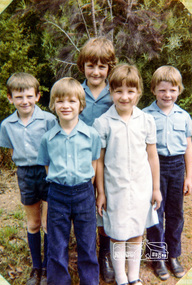 Eltham District Historical Society Inc
Photograph, Prep to Grade 2: Peter Whalley, David Prentice, Christopher Field at back (grade 2), Corey Giesbrecht (1) and Natasha Watts (Prep), Eltham Christian School, March 1983, 1983
Prep to Grade 2: Peter Whalley, David Prentice, Christopher Field at back (grade 2), Corey Giesbrecht (1) and Natasha Watts (Prep), Eltham Christian School, March 1983 The Stokes family settled in this area of Eltham in the 1940s and were associated with the Eltham Christian Church. In the 1970s this church had met in temporary premises in Eltham. Lots of the original 1920s subdivision remained south of Nyora Road and a number of these lots were utilized for the Eltham Christian School, which was established by the Eltham Christian Church in 1981. The school operated on this site until 2000. The premises were owned by the Nillumbik Community Church who were in operation till November 2010 when the Eltham Baptist Church commenced a lease arrangement until the site was purchased by them in April 2012. The building is constructed of brick and timber with a balcony on two sides that looks over an expanse of grass. Sources: STOKES ORCHARD – AN INCOMPLETE HISTORY February 28, 2015 http://www.elthamhistory.org.au/ Australian Christian Church Histories - Eltham Baptist Church http://www.churchhistories.net.au/church-catalog/eltham-vic-baptist/ From an album featuring a series of photographs (some cropped) from a magnetic photo album relating to the staff, students and activities of the Eltham Christian School which operated as part of the Eltham Christian Church at Nyora Road, Eltham. See also entries for each photograph.Colour photographeltham christian school, nyora road, peter whalley, david prentice, christopher field, corey giesbrecht -
 Eltham District Historical Society Inc
Photograph, Demolition of the former Shire of Eltham building, Main Road, Eltham, 2 Aug 1996, 1996
The Shire of Eltham Office was constructed in the late 1960s on the original site of Shillinglaw Cottage. Upon cessation of the Shire as a local government body following dismissal of councils by the Kennett Liberal Government in December 1994, the new Nillumbik Shire offices were located in Civic Drive, Greensborough. The Shire of Eltham office building was demolished and the site has remained vacant ever since. The three pine trees which featured in front of Shillinglaw Cottage and then the Shire of Eltham Offices remain standing on the vacant site as of 2017. Roll of 35mm colour negative film, 7 stripsKodak Gold 100-5eltham, main road, shire of eltham, shire of eltham office -
 Eltham District Historical Society Inc
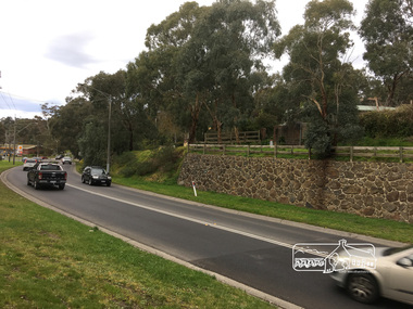
Photograph, Peter Pidgeon, Site of the original Catholic Church but was too far from centre of community, Main Road, Eltham, 2 Sep 2017
Heritage Excursion - An Eltham South Ramble, 2 Sep 2017Born Digitalactivities, eltham district historical society, eltham south, heritage excursion, local history centre -
 Eltham District Historical Society Inc
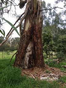
Photograph, Peter Pidgeon, Large Manna Gum Scar Tree, Wingrove Park. A significant site for the Wurundjeri, 2 Sep 2017
Heritage Excursion - An Eltham South Ramble, 2 Sep 2017Born Digitalactivities, eltham district historical society, eltham south, heritage excursion, local history centre -
 Kiewa Valley Historical Society
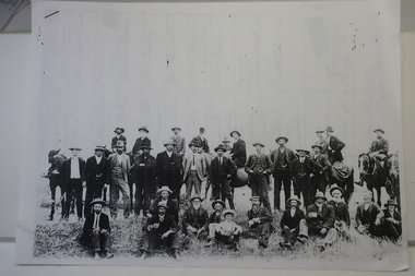
Papers photocopied - photo, list of names, Kiewa Valley Pioneers and Early Activities on the Bogong High Plains
All Early History of the Kiewa Valley. 1. Photo clear but no date. Men named and are residents selecting a site for a bridge at Keegans Crossing 2. Department of Crown Lands letter - 1841 Tawonga pastoral run - Mr James Roberts and Mullindollingong pastoral run 1846 - Mr Patrick Reynolds 3. An account of the Bogong High Plains by W. F. Waters from the late 1890s to 1930s. Published article in the Schuss magazine. August 1958 History of Keegan's Crossing, Kiewa Valley and surrounding residents with names and photos. Early pastoral runs in the Kiewa Valley and Early activities on the Bogong High Plalns..1.The photo includes a listing of residents selecting a site for a bridge at Keegans Crossing. 2. A letter from the Department of Victorian Lands and Survey re early settlers 3. History written in Schuss magaine, Aug. 1958. "In 1896 ... erection of snow poles from Rocky Valley to Tawonga Hut. keegan's crossing, w.f. waters, tawonga and mullindollongong pastoral runs -
 Kiewa Valley Historical Society
4 Photos framed - Kiewa Hydro Electric Scheme 1940s
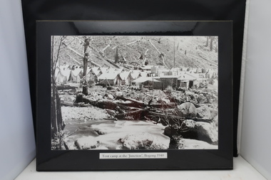
These 4 black and white photos are very clear and are of Bogong in the 1940s when the Kiewa Hydro electric Scheme was being constructed. Bogong was the first construction site. Bogong was a township and construction site for the Kiewa Hydro Electric Scheme built by the State Electricity Commission of Victoria. These photos in the early 1940s (during WW2) tell the story of fire, flood and living conditions with the inference of transport being horses in 1940 compared with its development in 1944.1. Tent camp at the 'Junction', Bogong 1940 2. Junction Dam September 1940: floodwaters over coffer dam 3. 'Reservoir' Camp with Bogong Stables in foreground, 1940 4. Junction Dam and Bogong village in August 1944 Each photo has string attached on the back with tape - for hangingSticker on the back of each photo: 'Framing/ Colour Magic / Shop 7, Lismore Central / Carrington Street, Lismore / Phone (02) 6621 3289'bogong township 1940, junction dam 1944, reservoir camp 1940, bogong stables 1940, tent camp at bogong -
 Kiewa Valley Historical Society
Photos - King Family Collection
The King family lived in Tawonga South where my older brother and sister went to school. We lived over the road from Wally Madison's farm. Later when a house became available, we moved into Valley Avenue, Mt Beauty. This is when I turned 5 and started my schooling. It was a long walk for a 5 year old as I remember. Then later we moved to 50 Lakeside Ave. I remember we loved living there as it was close to the school, footy ground and kindergarten. My father, Ted King, wad a carpenter and was involved in the building of many houses in Mt Beauty which was the home for the workers on the Kiewa Electric Scheme. So as they are part of the history of Mt Beauty I thought they may be useful to you as part of the history. The tennis photos, I vaguely remember Lou Hoad and Ken Rosewell giving exhibition matches in Mt Beauty. I may stand corrected on this, but I do remember my parents who were keen tennis players themselves were most excited at seeing these famous tennis players. As I was only 9 when we left Mt Beauty to live in Dimboola I still remember the shock of leaving a beautiful mountainous county side and arriving in a flat farming land next to a desert and seeing windmills One thing I do remember from school is, once a week (or fortnight) the teacher used to come around with a jar of little white pills, of which we were all to take. I really don't know what they were?? or for?? I also remember being taught to swim in the freezing cold river by a Mrs Smith who wore black bathers and wore her hair in a bun...... ...I am now in my 70s My father used to also carve intricate trays and jewellery boxes in his spare time. I think they were used for tennis trophies. by Diane Werner.x33 photos of small black and white photos of the Tawonga, Tawonga South and Mt Beauty - Photos not labelled but described as follows. See each photo for a possible label. A. Tawonga? B. Mt Beauty taken on the road to Bogong ? C. SEC Works D. Industrial buildings with mountains in the background E. Building site with wooden frame and 3 men F. Buildings with power poles G. Building site with lots of huts H. Buildings under construction I. Group of houses in the distance J. Group of houses in the distance K. Group of people in front of a building L. Group of 8 men sitting on timber planks, corrugated iron at back. M.& N. Building site with floor and upright timbers O. Mountain view with camp site in foreground P.& Q. Buiding site, several houses R.5 men at a building site S. portable building on trailer T & U. Mountain view V. Building site W. Group of men, car and mountains in background X. Cows Y. Pigs Z. 2 men standing next to cars. AA. Football players BB. Man painting a corrugated iron building CC. Football DD. Men in front of a building EE Buildings with mountains in background FF & GG Tennis payersHH & II. Electricity infrastructure -
 Kiewa Valley Historical Society
Dress - Bridesmaid's Dress
Bridesmaid's dress worn at Margaret Rose Vyner and Ian McKendrick's wedding on 11th January 1958The McKendrick family came to Mt Beauty very early in the Kiewa Hydro Electric Scheme (KHES) days. Their son, Ian, worked in the Mt Beauty Post Office for 40+years. Vyner family also long time employees of the SECV on the KHES. They were residents of Mt Beauty. Margaret was a nurse at the Tawonga District Hospital at the Tawonga site . White sleeveless dress with a taffeta underskirt with 2 tulle gored over skirts. The bodice is tulle over taffeta with fitted bodice, scooped neckline decorated border of lace and diamantes with a side zip.Maker's Tag: Milady's Robesbridesmaid's dress, vyner family, mckendrick family -
 Kiewa Valley Historical Society
Dress - formal mourning
Formal mourning dress possibly worn by Mrs Vyner senior. This dress would have been made circa 1930s - 1940s. The McKendrick family came to Mt Beauty very early in the Kiewa Hydro Electric Scheme (KHES) days. Their son, Ian, worked in the Mt Beauty Post Office for 40+ years. The Vyner family also were long time employees of the SECV working on the KHES and were residents of Mt Beauty. Margaret was a nurse at the Tawonga District Hospital at the Tawonga site and the Mt Beauty site.Three quarter length black crepe dress with an 8 gored skirt and with a sash made of black crepe attached to the dress. Fitted long sleeved V neck bodice with satin applique and a pink nylon ruffle pleated around the neckline. Fitted sleeves with 2 covered buttons at the end. mourning dress, mckendrick family, vyner family -
 4th/19th Prince of Wales's Light Horse Regiment Unit History Room
Booklet (6 copies), Manual of Land Warfare Part 2 Infantry Training Vol 7 Pam 1 Mine, Anti-Personnel M18A1 (Claymore), 1979
A soft covered booklet providing information required to conduct training in siting, setting up, firing, neutralising and disarming the Mine, Anti-Personnel M18A1, Claymore . One copy has amdts 1 & 2. One copy has amdt 1.7610-66-099-2474mine, claymore -
4th/19th Prince of Wales's Light Horse Regiment Unit History Room
Photograph (2 copies), Prisoners, Esdrealan Plain, abt 1918
A black & white photo, showing a long line of prisoners under mounted escort on a flat open plain. There are three bodies in the foreground.No B258 Australian War Memorial, Exhibition Buildings, Melbourne. On back - 'Site of a battle between Indian Cavalry and enemy at Lejjun on Esdraelon Plain, also near site of Armageddon, Nazareth Hills in background. Prisoners captured during advance on Damascus'ww1, palestine, pow