Showing 455 items matching "slab"
-
 Eltham District Historical Society Inc
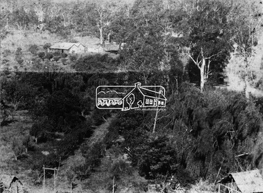
Photograph, Allwood, Hurstbridge, 1885
Allwood at Hurstbridge was named and first settled in 1837 by the Haley family. A house was built of one round of vertical slabs (red gum). Later it was the Hurst family home where Henry Hurst was shot by Burke the Bushranger on 4 October 1886. George Gray took over the property and the original home was eventually demolished. Gray, a fruit grower established an orchard and Allwood Nurseries which became a very successful business growing and exporting. This is probably around the time when this photo was taken where rows of fruit trees can be seen in the foreground. A house and associated buildings, possibly part of the nursery are behind. This photo forms part of a collection of photographs gathered by the Shire of Eltham for their centenary project book, "Pioneers and Painters: 100 years of the Shire of Eltham" by Alan Marshall (1971). The collection of over 500 images is held in partnership between Eltham District Historical Society and Yarra Plenty Regional Library (Eltham Library) and is now formally known as 'The Shire of Eltham Pioneers Photograph Collection.' It is significant in being the first community sourced collection representing the places and people of the Shire's first one hundred years.Digital imagesepp, shire of eltham pioneers photograph collection, diamond creek, hurstbridge, allwood, orchard -
 The Beechworth Burke Museum Research Collection
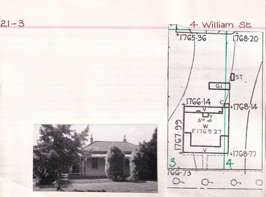
Card (Series) - Index Card, George Tibbits, 4 William Street, Beechworth, 1976
George Tibbits, University of Melbourne. Faculty of Architecture, Building and Town & Regional PlanningIndex system that support the research for Beechworth : historical reconstruction / [by] George Tibbits ... [et al]Arranged by street names of BeechworthEach index card includes: street name and number of property, image of property, allotment and section number, property owners and dates of ownership, description of the property according to rate records, property floor plan with dimensions.beechworth, george tibbitsbeechworth, george tibbits -
 The Beechworth Burke Museum Research Collection
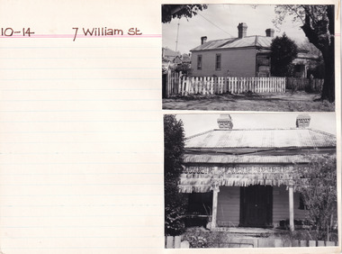
Card - Index Card, George Tibbits, 7 William St, Beechworth, 1976
Property - 7 William Street Beechworth, Section 10, Town Allotment 14, 100 x 250 Ownership details and history - 11 Apr 1856 - W.C. Hill 1857 F.J. Doull 1862 F.J. Doull, Land 33' x 165', Prem 21' x 13' x'9" / Prem 20' x 13'9" (occupier R. Nelson) 1866 - Land 33 x 165 Prem 20' x 13'9" slabs & bark, £7.10.0 1870 - T Dalziel - Land Only 66x165 1883 - Land Only Architectural Index Card - Brian Pump and Tony Dugan - Photographers beechworth, george tibbits -
 Uniting Church Archives - Synod of Victoria
Textile - Pulpit fall
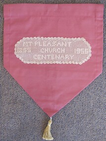
This pulpit fall commemorates the second Wesleyan church structure that was brought to Mount Pleasant from Clayton's Hill and erected at the corner of Morton and Tress Streets. It was about 30 feet long, 18 feet wide with slab sides and a canvas roof. The Rev Theophilus Taylor was one of the first preachers to conduct services in this church. It was the second church on the site, the first being a canvas tent erected in 1854. In 1857 a third, wooden, church was built with side buttresses and was later enlarged by transepts on each side. The Rev. Albert Briggs was the minister at Mt Pleasant in 1955. [Source: Peers, T. (compiler) 'Mount Pleasant Church 1855 - 2005' ]Cream crochet sewn onto rose coloured curtain fabric with a gold tassel. "'MT PLEASANT CHURCH CENTENARY 1855 1955"mt pleasant methodist church ballarat, rev theophilus taylor, rev albert briggs -
 Bendigo Historical Society Inc.
Photograph - HARRY BIGGS COLLECTION: BOORT CEMETERY
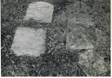
Black and White photo of two grave stones that have fallen onto the grass and broken. The one to the left is broken in two and on the right the grave is in four pieces. The Grave at the right (Granite Headstone) is that of George F. Campion a young Englishman who died at Boort Station on May 31st, 1851. Buried beside him (grave unmarked) was the baby boy of 'John & Jane' married couple on the Station. The grave on the left (marble slab) is that of George Bertram Godfrey, son of Henry & Mary Godfrey, aged 1 year 5 months. Photo taken Oct 1962, by Peter Coutts, Boort.memorials, graveboards, boort cemetery, boort cemetery -
 Kiewa Valley Historical Society
Razor Personal Vintage, circa 1940s to 1950s
This item(razor) was used by men, only before fashion dictated that women should shave their legs and underarms. There is information that this razor was first used circa 1922 and it lasted up until circa 1958. It permitted the user to have a compact shaving apparatus at hand in any environment. It provided a safe and easy way of sharpening the more permanent blade. This type of razor replaced the straight, open, or cut-throat razors. The mobility of this item was further enhanced by Gillette with their double bladed disposable razor. Time taken(shaving) and costs involved where crucial factors in the ever growing pace of domestic lifestyle in the post 1920s.This historical item presents that, even though the Kiewa Region was an inland rural settlement which in the 1920's was not as close to "modern" fashions and "gadgets", the basic living conditions where still maintained at city levels. This particular razor was in its heyday a sophisticated safety razor and brought down the demand for the services of the "professional" barber(shaver). One of the problems of the superseded straight razor was the high levels of cuts and nicks to the face. As this particular razor was fairly expensive it would have been used by men who were in the middle to upper socio-economical position in Kiewa Valley before the late 1950'sThis item is a Sheffield steel(stamped inside) metal box(Viscount model) containing a red leather fine shaving strap and in its lid a grey honing stone. Both bottom and top lids are removable to allow for replacements of strap and stone. On the bottom lid appears "The Whetter" trade mark, registered in the U.S.A. in 1950.Three bands of a Greek key pattern has been pressed on the lid. A circled identification inscription. " ROLLS RAZOR Ltd, MADE IN ENGLAND" and patented information appears within this inscription. "Patented in England and Abroad. English patents numbers 467383. 284428. 242718. 242717" On the outside of the base lid within a circle are "ROLLS RAZOR" and the sketch of a long haired naked man (side view), crouched, with both hands stretched forward operating the razor. On a slab underneath are the words "The Whetter"safety razor, non disposable, men's shaving implement -
 Halls Gap & Grampians Historical Society
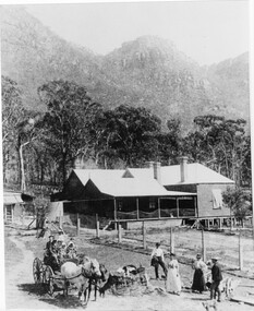
Photograph - B/W, C 1880
1880-1902 Land owned by Robert and Sarah Graham who owned a large portion of land best described as Upper Fyans Valley. At some time after 1880, they sold a parcel of the land under Sundial Peak to David Austin who built a slab hut. C1896, The land was sold to James and Amy Balmain which they named 'Bellfield' Amy was a daughter of John D/Alton who built the Stawell Water Supply System. Balmain purchased the vacant school cottage at Burnt Bridge and moved it to 'Bellfield' Over the next six years the house was enlarged to accommodate their growing family but sold in 1902 following the death of Amy Balmain.House with addition People leaving house by horse and carriage, people standing in groundsState Library Victoria, Rose's Australasian Views Victorian Series photographed and published by George Rose 123 Chapel St., Windsor, Victoriabuildings, houses, bellfield -
 RMIT Design Archives
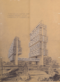
Diazotypes, Robin Boyd's Sketch for combined project 60-64 Clarendon St + corner site, 1968
Robin Boyd’s unbuilt scheme for two residential towers for Carnich Pty Ltd in East Melbourne is one of his most striking late projects – remarkable for its daring scale, its indebtedness to the megastructural polemics of Paul Rudolph and Japanese Metabolism, and its prescience – a high-rise apartment building now sits on the same site. The drawing is spectacular: trays of space are held aloft on angled concrete props that branch off trunk-like vertical slabs. With balconies and spandrels highlighted in white, the scheme’s dynamism echoes El Lissitzky’s mad Wolkenbugel (‘Skyhooks’) while also signalling a tragic last hurrah before Boyd’s 1971 death. Philip GoadIncludes sketch of two structures and surrounding flora.Inscribed upper left of recto, "ROBIN BOYD'S SKETCH FOR / COMBINED PROJECT 60-64 / CLARENDON ST. + CORNER SITE"architecture, mid-century modern, emigre, rmit design archives -
 Mt Dandenong & District Historical Society Inc.
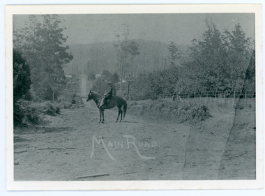
Photograph, Looking Down Falls Road
Edward John Price was a son of early settler Edward Joseph Price. Edward Joseph was the first settler in the Village Settlement when he took out Lot 1, Section 1. He built a small home of slabs and brought his family up in 1896. From the outset the Price family ran a store from their home.This picture, taken 1914, shows Edward John Price on his pony delivering papers from his parent's newsagency that was opposite 'Mountjoy' guesthouse on Ridge Road. He was taking them to Lily Badenhop's post office in Blythe's Road. The section of road he is on was called Main Road and is now Falls Road.Black and white photograph showing a man on horseback in the centre of an unmade road that is running into the distance.Trees, a fence and houses can be seen with hills in the background. Reverse of photograph has handwritten description by John Lundy-Clarke.On Front MAIN ROAD On Reverse Looking down Falls Road then the main road in 1914. Before Frank Craig built The Fron (1918). Dunbar’s house Halcyon on left of road. The hall on its right with Keogh’s sheds showing further in the trees. The horseman is Edward John Price who delivered the daily papers to Lil Badenhop’s shop. The bag he carried them in can be seen hanging from the saddle pommel. The first road formation can be seen on the bank to the right. The road seen was constructed 1905 by Bill McGivern.edward john price, edward joseph price, lily badenhop, post office, falls road, main road, mountjoy, frank craig, bill mcgivern, dunbar, halcyon, keogh, farndons hall -
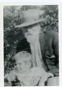 Mt Dandenong & District Historical Society Inc.
Photograph, Edward Joseph Price and Grandson
John Lundy-Clarke grew up in the Kalorama/Mt Dandenong area and later in life (1972-74) began to write a comprehensive history of the district working from an original settlement map in an effort to cover all areas. Edward Joseph Price took out Lot 1, Section 1 of the Village Settlement and became the first settler, moving his family up into a slab hut on his selection in 1896. Edward Joseph had two sons (Charles Joseph and Edward John) and a daughter (Kathleen Nathalie Caroline). Edward Joseph Price is holding his grandson Teddie, son of Edward John Price. Photo taken 1936.Black and white photograph in close up showing an old man with a white beard wearing a brimmed hat holding a male toddler under the arms. Reverse of photograph has handwritten description by John Lundy-Clarke.Edward Joseph Price and his grandson Teddie son of Edward John. E. Joseph was the first settler in the Village Settlement choosing LOT 1, part of which is still family property (1974). He worked for the surveyors who were marking out the blocks, and disregarded their advice as to which had the best soil, and so doing he obtained the best commercially. He died in 1943 leaving two sons & daughter. Edward John born 1899 died 1974. Charles born 1892 died 1958. Kathleen born 1895 died 1954. Wife Annie nee Ross died 1932.edward joseph price, edward john price, teddie price -
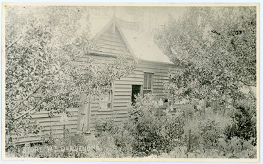 Mt Dandenong & District Historical Society Inc.
Photograph, Home and Shop of Edward Joseph Price
John Lundy-Clarke grew up in the Kalorama/Mt Dandenong area and later in life (1972-74) began to write a comprehensive history of the district working from an original settlement map in an effort to cover all areas. Edward Joseph Price was the first settler to take up a lot (Lot 1, Section 1) in the Village Settlement. He built a slab hut and brought up his family in 1896. This photograph shows a newer home built in 1908. It had a section used as a shop and also had a large room built that was to be used for public gatherings. Health department regulations led to this being impossible. The house faced Ridge Road.Black and white close up photograph showing a building made from wooden boards with trees in the front. Reverse of photograph has handwritten description by John Lundy-Clarke.On Front STORE MT DANDENONG On Reverse Home and Shop of Edward Joseph Price LOT 1 SECT 1 erected in 1908 on site of earlier dwelling from which goods had been sold without a special room for shop. In picture the room on the extreme left was bedroom for boys Charlie and Ted (Edward John). Under the gable was a large room planned for public use but never used owing to Health Department Regulations. The narrow door (open) and window were the shop which was the district’s first newsagency. Window behind leaves at right was the kitchen. 1908-1912. Gabled portion is now part of home “Mirra Laken” 1975edward joseph price, store, shop -
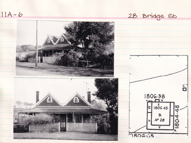 The Beechworth Burke Museum Research Collection
Card (Series) - Index Card, George Tibbits, 28 Bridge Street, Beechworth, 1976
George Tibbits, University of Melbourne. Faculty of Architecture, Building and Town & Regional PlanningIndex system that support the research for Beechworth : historical reconstruction / [by] George Tibbits ... [et al]Arranged by street names of BeechworthEach index card includes: street name and number of property, image of property, allotment and section number, property owners and dates of ownership, description of the property according to rate records, property floor plan with dimensions.beechworth, george tibbitsbeechworth, george tibbits -
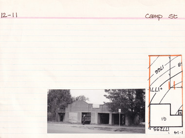 The Beechworth Burke Museum Research Collection
Card (Series) - Index Card, George Tibbits, Camp Street, Beechworth, 1976
George Tibbits, University of Melbourne. Faculty of Architecture, Building and Town & Regional PlanningIndex system that support the research for Beechworth : historical reconstruction / [by] George Tibbits ... [et al]Arranged by street names of BeechworthEach index card includes: street name and number of property, image of property, allotment and section number, property owners and dates of ownership, description of the property according to rate records, property floor plan with dimensions.beechworth, george tibbitsbeechworth, george tibbits -
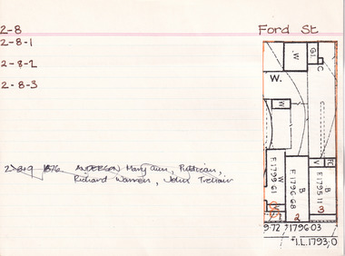
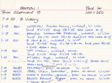 The Beechworth Burke Museum Research Collection
Card (Series) - Index Card, George Tibbits, Ford Street, Beechworth, 1976
George Tibbits, University of Melbourne. Faculty of Architecture, Building and Town & Regional PlanningIndex system that support the research for Beechworth : historical reconstruction / [by] George Tibbits ... [et al]Arranged by street names of BeechworthEach index card includes: street name and number of property, image of property, allotment and section number, property owners and dates of ownership, description of the property according to rate records, property floor plan with dimensions.beechworth, george tibbitsbeechworth, george tibbits -
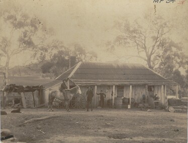 Bendigo Historical Society Inc.
Photograph - FARMHOUSE NEAR MT SUGARLOAF - SLAB HUT, c.1880
Sepia photograph. Slab hut with bark roof, verandah. One brick chimney, weatherboard skillion at L end. One male under verandah. One male in yard. One male mounted on horse. Barrels, wheelbarrow, four wheeled horse drawn vehicle under or near verandah. Inscriptions on front 'MP94', in red ballpoint ink '28'.On Back in grey lead 'Axedale family near Sugarloaf'.( near Fosterville ) On back in red ball point pen '28'. History of object: Previous Acc. No. 'MP 94'. An important photo of early settlers showing type and construction of farmhouse, type of farm implements and clothingBendigo Advertiserbuildings, residential, cottage -
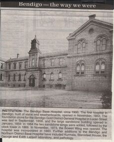 Bendigo Historical Society Inc.
Newspaper - JENNY FOLEY COLLECTION: INSTITUTION
Bendigo Advertiser "The way we were" from 1999. Institution: The Bendigo Base Hospital, circa 1900. The first hospital in Bendigo, built of slabs and weatherboards, opened in November, 1853. The foundation stone for the Bendigo Gold District General Hospital in Lucan Street was laid in September, 1858, and the large sandstone building opened in January, 1859. In 1864, the two sandstone wings were added followed by the clock tower in 1866. In November, 1873, the Bowen Wing was opened. The hospital was incorporated in 1883. Further additions to the Bendigo and Northern District Base Hospital have included Kurmala, Stanisteet House, the George and Edith Lansell laboratory, and pathology.newspaper, bendigo advertiser, the way we were -
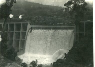
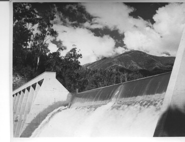 Kiewa Valley Historical Society
Photograph of Lake Guy Dam, Spillway, Lake Guy Dam, c1945
In December 1939 the excavation of the diversion tunnel at the site of Junction (Lake Guy) Dam was commenced and finished in February, 1940.This allowed the stream to be diverted to facilitate the dam wall construction. This is a 'slab and buttress' dam. It is framed with timber and concrete then poured into the structure. A contract was let to Lewis Construction Co. for the construction of the dam, and the first batch of concrete was placed in September, 1940. Industrial trouble caused some delays but there was also slow progress on the part of the contractor and the work was taken over by the S.E.C., terminating the contract. The dam was completed in March, 1944. The lake is named after Mr. L.T. Guy who was the Resident Engineer, in charge of construction work and associated activities on the Kiewa area, from 1939 until November 1946. An historical pictorial record taken for the State Electricity Commission of Junction Dam (Lake Guy) on spill. Mt. Arthur is in the background and there is still evidence of the destruction of trees from the 1939 bushfires. Black and white photograph of Lake Guy Dam . The dam is spilling and Mt. Arthur is in the background. Hand written on back of photograph in blue ink " Lake Guy Dam".dam, lake, water, mr. l.t.guy -
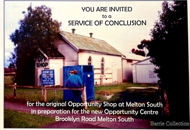 Melton City Libraries
Flyer, Melton South Uniting Church Opportunity Centre, 2016
The Opportunity Shop – Established 1975 by Edna Barrie 1992 In 1985 the need for more shop space became apparent. Les [Bone] had plans drawn up (Surv 12/8/84) and approved by the Melton shire Council for a storeroom extension (17.800 x 9500) 1986 the small ancillary rooms at the rear of the timber church were demolished allowing the concrete slab to be laid. The building was completed in 1987. By the early 1900s the old timber Church had deteriorated, this lead to it being demolished in 2/11/1993. It was replaced with a new building containing a Pastoral Office, a meeting room and a furniture and homeware section. It was dedicated by Rev Ian Hickingbotham at 11am Sunday 5th June 1994. Invites to the service of conclusion of the original Uniting Church Opportunity Centre and official opening to the new shop in Melton Southchurches, local identities -
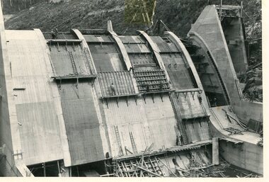 Kiewa Valley Historical Society
Photo - Junction Dam Construction, Circa 1940's
Junction (Lake Guy) Dam is a 'slab and buttress' type wall. A timber frame is built and then filled with concrete. The first batch of concrete was placed in September, 1940. By June, 1941 the buttresses were finished to a height safe from floods and in October of that year a flood of 2,800 cusecs occurred but with only slight damage to the installations. Industrial trouble caused some delays but there was also slow progress on the part of the contractor and the work was taken over by the S.E.C., terminating the contract. The dam was completed in March, 1944. A walkway was made through the dam wall. Lake Guy was named after Mr. L.T. Guy who was the Resident engineer, in charge of construction work and associated activities on the Kiewa Area from 1939 to November 1946Photos of the construction of the Junction Dam detail the harsh conditions faced by construction workers, building dams and villages to accommodate workers in the 1940s to the 1950s. Australia at this period in time, experienced a surge of population (influx of World War II refugees), which was the catalyst for developing and undergoing an enormous hydroelectricity program for the Alpine regions, both in Victoria and New South Wales. This program was initiated to supply electricity to the major southern Australian cities of Adelaide, Melbourne and Sydney. It was thought that these developments would reduce, if not eliminate, the requirement for coal driven power stations. However time has demonstrated that these power stations have not matched the demand required by the industries and the populations of the major urban and cities.Black and white photograph of Junction Dam constructionjunction dam, bogong, secv -
 Kiewa Valley Historical Society
Photo - Junction Dam Diversion Tunnel
Junction (Lake Guy) Dam is a 'slab and buttress' type wall. A timber frame is built and then filled with concrete. The first batch of concrete was placed in September, 1940. By June, 1941 the buttresses were finished to a height safe from floods and in October of that year a flood of 2,800 cusecs occurred but with only slight damage to the installations. Industrial trouble caused some delays but there was also slow progress on the part of the contractor and the work was taken over by the S.E.C., terminating the contract. The dam was completed in March, 1944. A walkway was made through the dam wall. Lake Guy was named after Mr. L.T. Guy who was the Resident engineer, in charge of construction work and associated activities on the Kiewa Area from 1939 to November 1946.Diversion dams are installed to raise the water level of a body of water to be redirected. The redirected water is used for hydro electric power generation. A diversion tunnel is usually bored through solid rock next to the dam site to bypass the dam construction site. The dam is built while the river flows through the diversion tunnel.Photos of the construction of the Junction Dam detail the harsh conditions faced by construction workers, building dams and villages to accommodate workers in the 1940s to the 1950s. Australia at this period in time, experienced a surge of population (influx of World War II refugees), which was the catalyst for developing and undergoing an enormous hydroelectricity program for the Alpine regions, both in Victoria and New South Wales. This program was initiated to supply electricity to the major southern Australian cities of Adelaide, Melbourne and Sydney. It was thought that these developments would reduce, if not eliminate, the requirement for coal driven power stations. However time has demonstrated that these power stations have not matched the demand required by the industries and the populations of the major urban and cities.Black and white photograph of Junction Dam diversion tunnel at Bogong VillageHandwritten on back - Junction Dam Diversional Tunnelbogong, secv, junction dam, lake guy -
 Kiewa Valley Historical Society
Photograph - Junction Dam spilling
Junction (Lake Guy) Dam is a 'slab and buttress' type wall. A timber frame is built and then filled with concrete. The first batch of concrete was placed in September, 1940. By June, 1941 the buttresses were finished to a height safe from floods and in October of that year a flood of 2,800 cusecs occurred but with only slight damage to the installations. Industrial trouble caused some delays but there was also slow progress on the part of the contractor and the work was taken over by the S.E.C., terminating the contract. The dam was completed in March, 1944. A walkway was made through the dam wall. Lake Guy was named after Mr. L.T. Guy who was the Resident engineer, in charge of construction work and associated activities on the Kiewa Area from 1939 to November 1946Photos of the construction of the Junction Dam detail the harsh conditions faced by construction workers, building dams and villages to accommodate workers in the 1940s to the 1950s. Australia at this period in time, experienced a surge of population (influx of World War II refugees), which was the catalyst for developing and undergoing an enormous hydroelectricity program for the Alpine regions, both in Victoria and New South Wales. This program was initiated to supply electricity to the major southern Australian cities of Adelaide, Melbourne and Sydney. It was thought that these developments would reduce, if not eliminate, the requirement for coal driven power stations. However time has demonstrated that these power stations have not matched the demand required by the industries and the populations of the major urban and cities.Black and white photograph of Junction Dam spilling at Bogong VillageHandwritten in pencil - Junction Dam spillingbogong, junction dam, lake guy, secv -
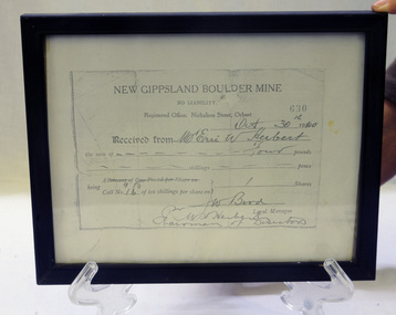 Orbost & District Historical Society
Certificate - share, 30/10/1940
Share certificate issued by New Gippsland Boulder Mine - operating at Errinundra and receipt for Herbert, Eric W. Receipt is for amount of four pounds - signed by Bird, W. Prospectus was printed in 1934 at office of Snowy River Mail - 4 page booklet. Gold, copper and silver were the target minerals.The crusher from the Boulder Mine is now at the Slab Hut in Orbost. The first Gippsland Boulder Co.,was at Boulder Creek – 13 miles north of Club Terrace, within 2 miles of Errinundra River. The company registered in January 1898 and commenced crushing in September with a 10-head battery. In the first nine months’ yields totalled 1,418 oz from 972 tons.There was a tramway between the mine workings and the battery.The crusher from the Boulder Mine is now at the Slab Hut in Orbost. This document is a reference for gold mining and exploration in the Far East Gippsland area. The Herbert family has reside in Orbost since the late 19th century.Copy of New Gippsland Boulder Mine share certificate and receipt. Framed in small black wooden frame.certificate-share-new-gippsland-boulder-mine mineralogy mining boulder-creek -
 Bendigo Historical Society Inc.
Document - Bendigo Base Hospital, 1853-1970s
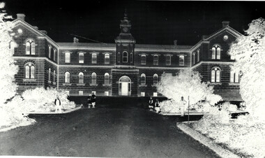
The hospital was first mooted in 1853. The first site chosen was "Hospital Hill" between Rowan and Mackenzie Streets and behind the present Lister House School of Nursing. The first building was a primitive affair of slab and weatherboard daubed with clay somewhere near the middle of the present Short St - which at the time extended to the brow of the hill behind the Sacred Heart Cathedral site. The new building was greatly need to serve the hundreds of diggers then active on the field. Messrs Vahland and Gezchmann, Architects, designed a new building of stone and brick, the cenre portion of the hospital to hold 100 beds. This centre portion cost 12,000 pounds and was erected in three months. Patients were transferred from the old site on Hospital Hill to the new building in December 1858.Black and White photo negative of the front of the hospital; Notes on the History of "The Bendigo Gold District Hospital"; letters re classification by the National Trust of Australia (Victoria).history, national trust bendigo collection, bendigo, bendigo base hospital, bnedigo hospital, bnedigo gold district hospital -
 Bacchus Marsh & District Historical Society
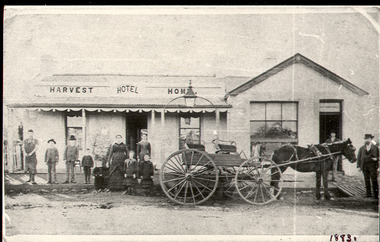
Photograph, Harvest Home Hotel Main Street Bacchus Marsh c.1880s-1890s
The Harvest Home Hotel was licensed as a beer shop in 1866. Patrick Vallence was the licensee. On his death in 1874 his widow Mrs M. A. Vallence obtained the license. The date that this image was created has not been identified. Around 1883 George Marshall was leasing the hotel. The people in this image are could be members of the Marshall family and some of the staff who worked in the hotel at this time. Following a decrease in the population of Bacchus Marsh by 1911 the hotel had lost its licence. The Vallence family still owned the building after the loss of the hotel license in 1911and it was used for some years after this as a private residence by some members of the Vallence family. Small black and white photograph. The image depicts the Harvest Home Hotel situated in Main Street Bacchus Marsh. The name of the hotel can be seen above the verandah roof. The building appears to be of stone with decorative stonework corners. A verandah is inset to the left of a gabled front section which has its own door and window. A deep gutter runs along the front of the hotel, with a slab acting as a bridge to the road. Standing in front of the building facing the camera is a group of adults and children, men and women and boys and girls. A four seated buggy drawn by a single horse is also present in the image. The lantern erected above the horse trough can be seen.hotels bacchus marsh, vallence family bacchus marsh, marshall family bacchus marsh, harvest home hotel bacchus marsh -
 Eltham District Historical Society Inc
Folder, Warrandyte Miner's Cottage, 1984
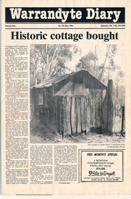
Report and photograph about purchase of historically significant slab cottage in Castle Road, Warrandyte. Newspaper also includes articles relating to Jock Macneish and his ultra-light aircraft, construction of foot bridge over Andersons Creek, Mrs Ruth Norman, Warrandyte Co-op, local results of the 1981 census, construction of elderly citizens' flats in Stiggant Street (Warrandyte), South Warrandyte Primary School, Professor's Hill and Warrandyte Football Club. The road guide features advertisments for Inglenook Tea Rooms, Warrandyte, Warrandyte Recreation Reserve Cafe (Mrs C. Miller, Proprietress), Eltham Motor Garage, Plaza Cafe Eltham, Eltham Park Team Rooms, Diamond Creek Garage and Engineering Works and The Dean Guesthouse Strathewen.Complete issue of "Warrandyte Diary" No 145, May 1984 with feature article headed "Historic cottage bought". 12 pages with section cut out of back page. Also includes photocopy of Broadbents Roadguide: central Victoria, 1946 pages 230-231HG Booklet 281981 census, advertisment, andersons creek, castle road, diamond creek garage and engineering works, eltham motor garage, eltham park team rooms, footbridge, harry gilham collection, inglenook tea rooms, jock macneish, mrs c. miller, mrs ruth norman, plaza cafe eltham, professor's hill, senior citizens, south warrandyte primary school, stiggant street, the dean guesthouse strathewen, warrandyte, warrandyte co-op, warrandyte football club, warrandyte recreation reserve cafe, warrandyte slab cottage -
 Bendigo Historical Society Inc.
Newspaper - Lydia Chancellor collection: A Prussian priest gave Bendigo his heart
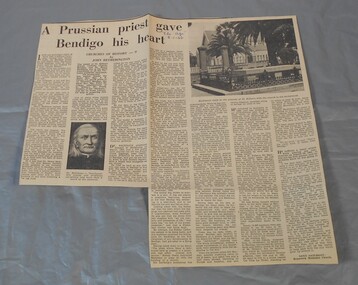
George Henry Backhaus (1811-1882) was born in Prussia. He was ordained as a Catholic priest in 1836 and began his missionary work in India. In 1846 he came to Australia, first ministering in Sydney and then Adelaide. With the discovery of gold in Victoria, Backhaus believed he was called to become a missionary on the goldfields. His first Bendigo mass was celebrated 2/5/1852. He travelled extensively throughout the goldfields eventually establishing a tent church on the site of St Killians in 1852. In 1853 this was replaced by a slab-walled and canvas-roofed church.. The site also included a Catholic school. In 1863 he returned to Germany but came back to Bendigo in 1867. He retired from parish work in 1881 and moved to Melbourne but as his health declined he returned to Bendigo in 1882 to die.The age from 08/01/1966. Article titled: A Prussian priest gave Bendigo his heart, Churches of history - 9 by John Hetherington. The article details the life of Dr. Henry Backhaus, the first Catholic priest in Bendigo.In blue pen "The Age" 8-1-66bendigo churches, backhaus, st.killian -
 The Beechworth Burke Museum Research Collection
Card (Series) - Index Card, George Tibbits, Corner Church, Ford & High Streets, Beechworth, 1976
George Tibbits, University of Melbourne. Faculty of Architecture, Building and Town & Regional PlanningIndex system that support the research for Beechworth : historical reconstruction / [by] George Tibbits ... [et al]Arranged by street names of BeechworthEach index card includes: street name and number of property, image of property, allotment and section number, property owners and dates of ownership, description of the property according to rate records, property floor plan with dimensions.beechworth, george tibbitsbeechworth, george tibbits -
 The Beechworth Burke Museum Research Collection
Card (Series) - Index Card, George Tibbits, 39 Ford Street, Beechworth, 1976
George Tibbits, University of Melbourne. Faculty of Architecture, Building and Town & Regional PlanningIndex system that support the research for Beechworth : historical reconstruction / [by] George Tibbits ... [et al]Arranged by street names of BeechworthEach index card includes: street name and number of property, image of property, allotment and section number, property owners and dates of ownership, description of the property according to rate records, property floor plan with dimensions.beechworth, george tibbitsbeechworth, george tibbits -
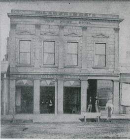 Bendigo Historical Society Inc.
Photograph - VIEW POINT HOTEL: BENDIGO
Black and white photo: View Point Hotel, Charing Cross, Bendigo. 2 storey rendered building with parapet. 4 rectangular windows at top. 3 large windows and doorway at bottom. Portion of single storey building at left with corrugated roof verandah. At right, single storey building without verandah. At front, slab lined drain, wooden trough at front with horse. 2 males standing in doorway. Inside building at bar, 1 male, 1 female behind bar. Lamp at front centre. In image: M. Langridge's/View Point Hotel/ Imperial Fire Insurance co./Office/Gilles & Co/Stock and Share brokers. ' Williams' on back in pencil '15'.batchelderbuildings, hotel, view point hotel -
 Eltham District Historical Society Inc
Photograph, Peter Pidgeon, Birch Cottage, Eltham-Yarra Glen Road, Christmas Hills, 27 September 2018, 2018
Originally built by John Hill, a shoemaker at Kangaroo Ground around 1878. In the late 1970s when our Society was the Shire of Eltham Historical Society, an offer was made to the Society regarding use of an old cottage at Christmas Hills. The cottage sat beside Watsons Creek just outside the then Shire of Eltham but following municipal restructuring it now lies within the Shire of Nillumbik. For various reasons the offer ultimately lapsed. At that time some research on the cottage was carried out for the Society by Keith Chappel as part of a larger research project that he was doing. Keith’s notes were taken from Lands Department records and showed that the property was the subject of a permissive occupancy of Crown land comprising the creek reserve. In 1903 a Miner’s Right of one acre in area was granted to Edwin Samuel Birch. In 1907 Birch applied to purchase this land but was unable to because it was part of the creek reserve. The documents show that the cottage existed at that time. Upon Birch’s death in 1932, his daughter, Honor Mary Birch was granted a permit to occupy the residence. Honor Mary Birch, known as Nora, was born 1900, the daughter of Edwin Samuel Birch and Honor (nee Young). In 1939 she married George Henry Williams (aka Henry). Honor died 8 July 1976. Her siblings were Margaret Martin (dec), Bert Birch and Brigidene Brinkkotter. In her will she gave and bequeathed “all the improvements on the land held by me at Christmas Hills under Permissive Occupancy from the Department of Land and Survey consisting of the house property thereon and all the contents of the said house to my nephew Brian Joseph Martin of Christmas Hills aforesaid farmer”. The will described the property as a four room, five square house, about 100 years old with enclosed verandah, including kitchen, combined lounge dining room, bedroom and store room; built of ‘bush slabs’ with a corrugated iron roof. A dairy had been erected in 1935. After her death, the property was acquired by the Melbourne Metropolitan Board of Works in 1978. The property is listed on the Victorian Heritage Database HO200-Hill, later Birch farm complex, 945 Eltham-Yarra Glen Road, Watsons Creek and described as: The house has a steep but simply gabled roof form clad with corrugated iron, vertical adzed hardwood slab front wall construction, split palings to the gable ends; rubble freestone chimney at one end (with added gsi flue), pole-framed Graeme Butler & Associates, 2006: 101 Shire of Nillurnbik Planning Scheme Amendment C13 Heritage Assessments verandah (rebuilt?); six-pane double-hung sash windows; T&G bead-edge boarded ledged & braced door; and paling clad rooms added at verandah ends. A slab-clad large fireplace is at the north corner of the house, with a gsi upper cladding added and an internal lining of rubble stone. The rear facade is different construction, being drop-slab, and sits beneath a rear skillion addition to the main gabled form: this may be more recent construction. The house appears to have been once set up for public display and may have been recreated in part for that purpose. Outbuildings are reached by a track along the east side of the house, including what may have been a creamery (typical standard inter-war design clad with corrugated iron and lined with 1938 Lysaght Queens Head Australia galvanised sheet iron) and a paling clad gabled out-house. Timber outbuildings of differing eras are to the north-west of the house, with pole framing and paling infill construction and Redcliffe brand corrugated iron. Post and rail (front) and split paling (rear) fence remnants line the front boundary. Pepper trees part of house yard landscape49 born digital images (includes one panoramic stitch and nine frames from drone video)birch cottage, christmas hills, early settlers, edwin samuel birch, honor mary birch, john hill, watsons creek