Showing 690 items
matching survey regiment
-
 Bendigo Military Museum
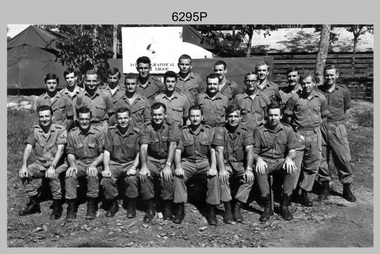
Photograph - A Section, 1st Topographic Survey Troop, Nui Dat, Vietnam, 1969
... Army Survey Regiment... was the CO of the Army Survey Regiment from 1975 to 1976 and CO... Survey Regiment’s Collection. The photograph was scanned at 300...Army Survey Regiment... was the CO of the Army Survey Regiment from 1975 to 1976 and CO ...This is a photograph of A Section, 1st Topographic Survey Troop taken at Nui Dat, Vietnam in 1969. A nominal roll of personnel and their trade as of the 30th of September 1969, accompanies this photo. Their trades in this photo were as follows - Surveyors Topographic: WO1 Darby Munro, SGT Paddy Strunks, SGT Graeme Birrell, CPL Brian Knight, CPL Colin Laybutt, SPR Roderick Gilbert and SPR Rodney Offer. Draughtsmen Topographic: SGT Terrance Linz, CPL Robert Kay, SPR Peter Aukstinaitis, SPR Lloyd Patterson and SPR Ian Wark. Photographer Cartographic: CPL George Graham. Clerk Admin: CPL Oreste Biziak. Helioworker: CPL Geoffrey White, SPR Lance Percey. Cook AACC: PTE R. Johnston. The first Royal Australian Survey Corps troops arrived in South Vietnam on the 10th of June 1966. This was a detachment from 1st Topographic Survey Troop, which was to give cartographic support to the Australian Task Force. Their main tasks were to establish a Theatre Grid, map compilation and map revision. Engineer Survey Support in the camp and to the civil community and give assistance to the Cordon Search Missions by producing large scale plots from aerial photos with every house and fence etc plotted and then reproduce these by silk screening usually, within a 24-hour period. This support concluded with the withdrawal of Australian troops from Vietnam in 1972. For more information on the career of A Section’s OC MAJ Peter Constantine AM, refer to item 6159P or 6092P. He was the CO of the Army Survey Regiment from 1975 to 1976 and CO of the School of Military Survey (SMS) from 1976 to his retirement in January 1982. His memoirs of active duty in Vietnam ‘Surveyor - Printer Behind the Lines’ was published in 2022. 2IC CAPT Frank Thorogood SB St J’s career culminated at the rank of LTCOL as the CO Army Survey Regiment from 1980 to 1981. More information on the A Section, 1st Topographic Survey Troop and the Army Survey Regiment’s supporting role is provided in pages 89 to 94 of Valerie Lovejoy’s book 'Mapmakers of Fortuna – A history of the Army Survey Regiment’ ISBN: 0-646-42120-4.This is a photograph of A Section, 1st Topographic Survey Troop taken at Nui Dat, Vietnam in 1969. The black and white photograph was printed on photographic paper and is part of the Army Survey Regiment’s Collection. The photograph was scanned at 300 dpi. .1) - Photo, black & white, 1969. Back row L to R: SPR Lance Percey, SPR Bruce Grisdale, SPR Rodney Offer, SPR Roderick Gilbert, CPL Geoffrey White, PTE R. Johnston, CPL Colin Laybutt, SPR Lloyd Patterson. Centre row L to R: SPR Peter Aukstinaitis, SPR Ian Hanna, SPR Ian Wark, CPL Robert Kay, CPL George Graham, CPL Oreste Biziak, CPL Brian Knight. Front row L to R: SGT Terrance Linz, SSGT Gordon Haswell, 2IC CAPT Frank Thorogood SB St J, OC MAJ Peter Constantine AM, WO1 Darby Munro, SGT Paddy Strunks, SGT Graeme Birrell.An A4 nominal roll of personnel and their trade accompanies the photo, as of the 30th of September 1969. A torn paper identifies the personnel in the photo. Annotated on back of photo – ‘Unit Photo – 1 Topo Svy Tp 30 Sept 69’royal australian survey corps, rasvy, army survey regiment, army svy regt, fortuna, asr -
 Bendigo Military Museum
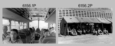
Photograph - Army Survey Regiment’s Tug-of-War Team at Simpson Barracks, Watsonia, c1989
... Army Survey Regiment...These eight photos of the Army Survey Regiment’s Tug-of-War...These eight photos of the Army Survey Regiment’s Tug-of-War...Army Survey Regiment...These eight photos of the Army Survey Regiment’s Tug-of-War ...These eight photos of the Army Survey Regiment’s Tug-of-War Team were most likely taken at Simpson Barracks, Watsonia in circa 1989. There is no information available on why the unit sent the team to Melbourne, the occasion, and the winner of this contest. It may have been a military athletics carnival held to commemorate Australia’s First Fleet bi- centenary, noting there was other members of Army Svy Regt on the bus who were not part of this team. The team’s coach was WO1 Ken Slater. Tug-of-War contests were very popular for the competitors and spectators, as they were often held at the Regiment as a component of inter-squadron athletics competitions, Flag Day verses the School of Military Survey, Bones Day verses the RAAF’s the School of Radio and a component of regimental training.These eight photos of the Army Survey Regiment’s Tug-of-War Team were most likely taken at a competition held at Simpson Barracks, Watsonia circa 1989. The photographs were on 35mm negative film and were scanned at 96 dpi. They are part of the Army Survey Regiment’s Collection. .1) - Photo, black & white, c1989, L to R: Neil Jones, WO1 Ken Slater, WO1 Brian Mead, unidentified (x2), Dave Cook, John Lane and Barry Miller. .2) - Photo, black & white, c1989, L to R: Rhys De Laine, WO1 Ken Slater, unidentified, Phil Meagher, unidentified (x6), Dave Cook and Mick Gillham. .3) - Photo, black & white, c1989, L to R: unidentified (x2), Rhys De Laine, Phil Meagher, Neil Jones, John Lane, Dave Cook, Rick Warren, Mick Gillham, unidentified and WO1 Ken Slater. .4) to .6) - Photo, black & white, c1989, L to R: Rick Warren, Dave Cook, John Lane, Neil Jones, Phil Meagher, Rhys De Laine and unidentified (x2). WO1 Ken Slater in foreground. .7) - Photo, black & white, c1989, L to R: Rick Warren, Dave Cook, John Lane, Neil Jones, Phil Meagher, Rhys De Laine and unidentified (x2). .8) - Photo, black & white, c1989, L to R: unidentified (x2), Rhys De Laine, Phil Meagher, Neil Jones, John Lane, Dave Cook, Rick Warren.No personnel are identified.royal australian survey corps, rasvy, army survey regiment, army svy regt, fortuna, asr -
 Bendigo Military Museum
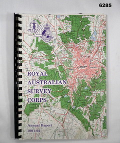
Administrative record - Royal Australian Survey Corps - Annual Report 1991 - 1992, Army Survey Regiment, 30 June 1992
... Army Survey Regiment... and a momento of 50th Anniversary Army Survey Regiment Parade...Army Survey Regiment... Fortuna Army Survey Regiment Army Svy Regt ASR Signed by Simon ...This is a report on the status of Royal Australian Survey Corps mapping and charting and geodesy for the period 1 July 1991 to 30 June 1992A4 Report, Part of Bendigo 1:100,000 map on the cover, Plastic ring binder., gloss paper pages, plastic folders inside back cover containing Indexes of Mapping production and a momento of 50th Anniversary Army Survey Regiment ParadeSigned by Simon Lemon, Director of the Royal Australian Survey Corps - Armyroyal australian survey corps, rasvy, fortuna, army survey regiment, army svy regt, asr -
 Bendigo Military Museum
Flyer - Lansell's Fortuna - Flyer, Army Survey Regiment, Circa 1980
... Army Survey Regiment... Tours conducted by the Army Survey Regiment. The Flyer has...Army Survey Regiment... Army Survey Regiment Army Svy Regt ASR The single page orange ...History of Fortuna Villa booklets were produced covering owners and occupiers, the building and the tours during Army tenure. A number of different versions of the Tour booklet were produced. Each version had a different colour cover. The orange covered edition of the booklet was the last version produced and printed and this flyer was produced as a handout companion for those tours. Contains a photograph of Fortuna Villa and a short history as well as location, cost, timings, other activities and booking information.The single page orange printed Flyer is for the Fortuna Tours conducted by the Army Survey Regiment. The Flyer has a photograph of Fortuna Villa taken from across the lake and is printed in orange on gloss paper. It contains a location diagram and details about the tours.royal australian survey corps, rasvy, fortuna, army survey regiment, army svy regt, asr -
 Bendigo Military Museum
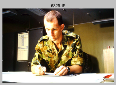
Photograph - Tasks Demonstrated by Royal Australian Survey Corps Technicians, c1990s
... Army Survey Regiment... 1990s. Photos .1P to .9P were taken at the Army Survey Regiment... at the Army Survey Regiment, Fortuna, Bendigo, and the School...Army Survey Regiment... 1990s. Photos .1P to .9P were taken at the Army Survey Regiment ...This is a set of 17 photographs of technicians from the Royal Australian Survey Corps undertaking technical tasks circa 1990s. Photos .1P to .9P were taken at the Army Survey Regiment, Fortuna, Bendigo. Photos .10P to .15P and .17P of students operating survey equipment, were taken at the School of Military Survey, Bonegilla and survey stations surrounding Lake Hume. The base camp at photo .16P was probably taken at Sandy Creek, near Tallangatta Victoria, during the field phase of a basic or advanced RA Svy training course. CPL Steve Nokes appearing in photo .17P was attending the 1/90 Map Control Survey Course.This is a set of 17 photographs of technicians from the Royal Australian Survey Corps undertaking technical tasks at the Army Survey Regiment, Fortuna, Bendigo, and the School of Military Survey, Bonegilla c1992. Colour photos are on 35mm slide film and were scanned at 96 dpi. Photo .17P is in black & white, printed on photographic paper and scanned at 300 dpi. The photos are part of the Army Survey Regiment’s Collection. .1) – Photo, colour, c1992, Aerial photography Assessment, SGT Tony Grivell. .2) – Photo, colour, c1992, Aerial photography Assessment, L to R: WO2 Noel McNamara and LCPL Grant Lloyd. .3) – Photo, colour, c1992, Wild PUG4 point transfer device, LCPL Mark Fedden. .4) – Photo, colour, c1992, AUTOMAP 2 Graphic Edit Workstation, unidentified technician. .5) – Photo, colour, c1992, Heidelberg Speedmaster 102 computer-controlled five colour lithographic offset printing press, CPL Nick Vanderzwan. .6) – Photo, colour, c1992, Daylight film contact frame, SPR Ken Labourchardiere. .7) – Photo, colour, c1992, Heidelberg Speedmaster 102 Map Colour Evaluation Workstation, SGT Stuart Ridge. .8) – Photo, colour, c1992, Map proof evaluation, CPL John Bragg. .9) – Photo, colour, c1992, Wohlenberg MCS-2 guillotine, unidentified technician. .10) – Photo, colour, c1992, Wild T2 Theodolite, L to R: SPR Matt Arnold, SPR Kim Baker. .11) – Photo, colour, c1992, Wild T2 Theodolite, L to R: SSGT Bob Bright, SPR Kim Baker. .12) to .14) – Photo, colour, c1992, MRA-7 Tellurometer, CPL Mark Bourne. .15) – Photo, colour, c1992, Plane Tabling, CPL Mark Bourne. .16) – Photo, colour, c1992, School of Military Survey base camp, Sandy Creek, VIC. .17) – Photo, black & white, 1990, MRA-7 Tellurometer, CPL Steve Nokes. .1P to .16P - There are no annotations. .17P – annotated on back ‘CPL NOKES WITH MRA7 ON 1/90 MAP CONTROL COURSE’royal australian survey corps, rasvy, army survey regiment, army svy regt, school of military survey, fortuna, asr -
 Bendigo Military Museum
Photograph - Army Survey Regiment’s Fortuna Lions Football Club Grand Finals, Seymour, Victoria, 1983
... Army Survey Regiment... photographs of Army Survey Regiment’s Australian Rules football team... of the Army Survey Regiment’s Collection. The photographs were scanned...Army Survey Regiment... photographs of Army Survey Regiment’s Australian Rules football team ...This is a set of seven colour and black and white photographs of Army Survey Regiment’s Australian Rules football team – the Fortuna Lions aka “Fortuna Fumblers”, taken at Seymour and Bendigo Victoria in 1983. The Fortuna Lions competed in the Puckapunyal Area Football Association for several years from 1978 to 1984 and in 1983, fielded a great team it managed to reach the Grand Final. Held at the neutral ground at Kings Park, Seymour, the match was an incredibly exciting and bruising contest played in damp conditions and ended in a draw. Dave Lawler’s spectacular mark was a highlight. Due to heavy rain during the following week, the Grand Final replay was held the following week in even heavier conditions. The Fortuna Lions prevailed in the replay with an emphatic victory. The team’s leaders were Eddie Jacobs (coach), Rhys De Laine (captain), Greg Else (vice-captain), and Ken Slater (manager). Refer to items 6244.27P (black & white) and 6245.26P (colour) for other photographs taken at the two grand finals.This is a set of seven photographs of Army Survey Regiment’s Australian Rules football team – the Fortuna Lions aka “Fortuna Fumblers”, taken at Seymour Victoria in 1983. The photographs were printed on photographic paper and are part of the Army Survey Regiment’s Collection. The photographs were scanned at 300 dpi. .1) - Photo, colour. 1983. Fortuna Lions Football Team - Back row L to R: Don Mawson, Stuart Ridge, Alan Staley, Doug Home, Dave Lawler, Greg Byers, Glenn Cannon, Keith Quinton, Mick ‘Buddha’ Ellis. Middle row L to R: Brian Paul, Dennis Learmonth, Greg Higgins, Jim Ash, Larry Thompson, Rhys De Laine, Eddy Jacobs, Ken Slater, Bob Thrower, Andy Godden, Nick Van Dalen, Peter Colwell, Warren ‘Wah’ Hall. Front row L to R: Mick Hogan, Rod Skidmore, Terry McIntyre, Greg Else, Terry Winzar, Peter Jones. .2) - Photo, colour. 1983. Fortuna Lions Football Team Grand Final Banner. .3) - Photo, colour. 1983. L to R: Kristin (Isaac) Skidmore, Santina (Argetto) Straube, Stuart Ridge, Nick Van Dalen, Larry Thompson, Jim Ash, Carmel (Butler) Fauth, Gayle Humphrey. .4) - Photo, black and white. 1983. Jim Ash in celebration. .5) - Photo, black and white. 1983. L to R: unidentified, Brian Fauth, Glenn Cannon. .6) - Photo, black and white. 1983. L to R: Doug Home, back of Warren ‘Wah’ Hall, Terry Winzar with premiership cup. .7) - Photo, black and white. 1983. Larry Thompson with premiership cup..1P to .7P – there are no annotations.royal australian survey corps, rasvy, army survey regiment, army svy regt, fortuna, asr -
 Bendigo Military Museum
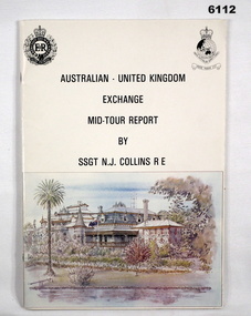
administrative record - Australian - United Kingdom Exchange Mid Tour Report by SSGT NJ Collins RE 1987, SSGT N.J. Collins RE, 29. 03.1987
... Army Survey Regiment..., a British Army Senior NCO on a two-year exchange to the Army Survey...Army Survey Regiment... to the Army Survey Regiment. Royal Australian Survey Corps RASvy ...The document is the Mid Tour Report by SSGT N.J. Collins RE, a British Army Senior NCO on a two-year exchange to the Army Survey Regiment. A4 size, Stapled, Front cover has a reproduction of a painting of Fortuna Villa in bottom half. Back cover has a difficult to see street scene of Pall Mall, Bendigo with a paragraph describing Bendigo's history superimposed. 19 Pages. The actual Report is contained on Pages 1-16. Annex A is 2 x pages plus a contents page.Green Hi-Light on parts of pages 10 and 11.royal australian survey corps, rasvy, fortuna, army survey regiment, army svy regt, asr -
 Bendigo Military Museum
Administrative record - Royal Australian Survey Corps 80th Birthday Parade 1 July 1995, Army Survey Regiment, Bendigo, June 1995
... Army Survey Regiment... 80th Birthday Parade held at the Army Survey Regiment Parade...Army Survey Regiment, Bendigo... 80th Birthday Parade held at the Army Survey Regiment Parade ...This is a booklet describing the Australian Survey Corps 80th Birthday Parade held at the Army Survey Regiment Parade ground at Fortuna on 1 July 1995. 1 July 1915 was the date of the formation of the Australian Survey Corps. The booklet lists the Reviewing Officer Major General GD Carter AM, Deputy Chief of the General Staff, Host officer, Official Guest, Senior Regimental appointments, the Order of Ceremony and a complete list of Army Survey Regiment members on parade.Small A5 sized booklet, soft cardboard covered with paper pages with two staples. Each page of the booklet has been scanned and combined into a video in .mp4 format. The video is 50Kb in size and runs for 50 seconds.royal australian survey corps, rasvy, fortuna, army survey regiment, army svy regt, asr -
 Bendigo Military Museum
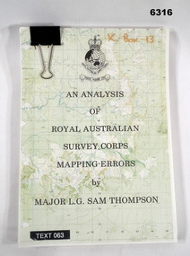
Administrative record - An analysis of Royal Australian Survey Corps mapping errors by Major LG Sam Thompson, Major LG Sam Thompson US Army Corps of Engineers at Army Survey Regiment, circa 1978
... Army Survey Regiment... making procedures at the Army Survey Regiment to quantify... Survey Regiment... making procedures at the Army Survey Regiment to quantify ...The purpose of the report is to analyze and study the map making procedures at the Army Survey Regiment to quantify the accuracy of the mapping to see if they meet acceptable accuracy standards. This was achieved through the study of possible errors.A4 loose leaf booklet held together with a "bulldog" paper clip. Cover part of an a RASvy 1:50,000 map. 1x Cover, 7x Introductory pages, 103x report pages.Marked on front cover "X - Box - 13", "TEXT 063"royal australian survey corps, rasvy, fortuna, army survey regiment, army svy regt, asr -
 Bendigo Military Museum
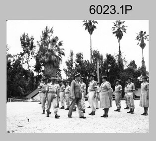
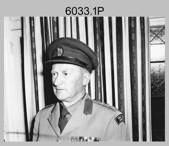
Photograph - Royal Australian Survey Corps Colonel Commandant and Director of the Survey Corps, c1960, 1962, c1969
... Army Survey Regiment... and the CO Army Headquarters Survey Regiment LTCOL Tim Tyler. Taken...Army Survey Regiment... Survey Regiment Army Svy Regt Fortuna ASR .1 no annotation 2.P ...COL Lawrence FitzGerald OBE was Director of the Survey Corps from 1942 to 1960 and was succeeded by COL Don Macdonald AM, MID. COL Frank Buckland OBE, MID succeeded BRIG Don Macdonald AM, MID as Director of the Survey Corps in 1967. He served as Director until 1972. BRIG Macdonald AM, MID was promoted before assuming the honorary position of Colonel Commandant of the Royal Australian Survey Corps. Royal Australian Survey Corps Colonel Commandant and Director of the Survey Corps c1969 at the Army Headquarters Survey Regiment, Fortuna Villa, Bendigo. .1 Black and white photograph: The Director of the Survey Corps COL Lawrence FitzGerald OBE inspecting the troops. Taken in c1960 on the parade ground at Fortuna Villa. .2 Black and white photograph: L to R: Director of the Survey Corps BRIG Don Macdonald AM, an unidentified British Officer and the CO Army Headquarters Survey Regiment LTCOL Tim Tyler. Taken in 1962 inside the Officers Mess at Fortuna Villa. .3 Black and white photograph: L to R: Colonel Commandant BRIG Don Macdonald AM and the Director of the Survey Corps COL Frank Buckland OBE. Taken in c1969 at the front steps to Fortuna Villa..1 no annotation 2.P named personnel annotated on paper sleeve, .3 named personnel annotated on back royal australian survey corps, rasvy, army survey regiment, army svy regt, fortuna, asr -
 Bendigo Military Museum
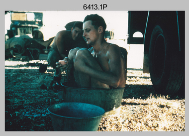
Photograph - Royal Australian Survey Corps Surveyors in the Field – North Queensland, 1958
... Army Survey Regiment... last appointment was the CO of the Army Survey Regiment from... and are part of the Army Survey Regiment’s Collection. The photographs...Army Survey Regiment, Bendigo... last appointment was the CO of the Army Survey Regiment from ...This is a set of seven photographs of surveyors and support staff in the field undertaking duties in North Queensland in 1958. The surveyors were employed in the establishment of mapping and geodetic control. In this era surveyors used theodolites to observe horizontal and vertical angles and chains to measure base line distances between survey stations. Bob Skitch shown in photos .4P to .6P was in the 2nd year of his career in the Australian Army. He achieved the rank of Lieutenant Colonel and his last appointment was the CO of the Army Survey Regiment from 1976 to 1980. The annotation on the back of photo .5P ‘Black foreground is where Bob Skitch boiled billy and started a grass fire’.This is a set of seven photographs of surveyors and support staff in the field undertaking duties in North Queensland in 1958. The photographs were printed on photographic paper and are part of the Army Survey Regiment’s Collection. The photographs were scanned at 300 dpi. .1) - Photo, colour, 1958. Surveyor in Nth QLD enjoying a bath. L to R: Don Cocker, Bob Thompson. .2) - Photo, colour, 1958. Don Cocker surveyor in Nth QLD, enjoying a bath. .3) - Photo, colour, 1958. Surveyors Nth QLD undertaking survey observations, using MRA1 tellurometer to measure base-line distances. L to R: Len Davies, Lou Sommer, John Van De Graff. MRA1 was covered to stop overheating. .4) - Photo, colour, 1958. Surveyors south of Richmond, QLD digging holes for the erection of a Bilby observation tower. L to R: John Van De Graff, Bob Skitch, Kev Moody, Mal Hayes, Don Gray .5) - Photo, colour, 1958. Surveyors south of Richmond, QLD erecting a Bilby observation tower. L to R: Tom Royle, Bob Skitch (on ground level), Mal Hayes. .6) - Photo, colour, 1958. Surveyors south of Richmond, QLD erecting a Bilby observation tower. L to R: Tom Royle, Bob Skitch, Mal Hayes, Jim McGill (on ground level). .7) - Photo, colour, 1958. Surveyors south of Richmond, QLD undertaking survey measurements from a Bilby observation tower..1P to .7P annotated on back – personnel names, the year and the location. Annotated on back of .5P ‘Black foreground is where Bob Skitch boiled billy and started a grass fire’.royal australian survey corps, rasvy, army survey regiment, asr, army svy regt, fortuna, surveying -
 Bendigo Military Museum
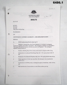
Document - Contingency Support Capability - Army Topographic Support Establishment (ATSE) Implementation, Army Survey Regiment, Bendigo, Apr - Jun 1995
... Army Survey Regiment....1 The Minute details that the Army Survey Regiment...Army Survey Regiment, Bendigo....1 The Minute details that the Army Survey Regiment ....1 The Minute details that the Army Survey Regiment is maintain a contingency production capability until ATSE is operational. .2 The Minute details the Data Aquisition Squadron requirements during the Implementation to ATSE. .3 The Minute details the Hardware, Software, Personnel and skills required during Implementation to ATSE. .4 The Instruction details that the non-core mapping, charting and geodetic (MC&G) activities of the Army Survey Regiment and 4 Fd Svy Sqn were tested under the Commercial Support Program (CSP) process resulting in the decision to award the contract for the provision of non-core mapping services to the ADF to the Preferred In-House Option (PIHO). .1 Contingency Support Capability - Army Topographic Support Establishment (ATSE) Implementation 26 Apr 95 (11 x A4 pages) .2 Data Acquisition Squadron (DAS) Contingency Support Capability - Army Topographic Support Establishment (ATSE) Implementation Apr 95 (4 x A4 Pages) .3 Contingency Support Capability - Army Topographic Support Establishment (ATSE) Implementation 28 Apr 95 (9 x A4 pages) .4 Directorate of Military Survey - Army Instruction for Implementation of the Army Topographic Support Establishment (ATSE) Jun 95 (10 x A4 pages)royal australian survey corps, rasvy, fortuna, army survey regiment, army svy regt, asr, atse -
 Bendigo Military Museum
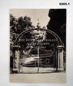
Booklet - The Royal Australian Survey Corps 1915-1965, Army Headquarters Survey Regiment, 14.11.1965
... Army Survey Regiment...) Anniversary of the Royal Australian Survey Corps, contains...Army Headquarters Survey Regiment... Survey Regiment Army Svy Regt ASR Inside of the booklet is signed ...A booklet produced to commemorate the 50th (Jubilee) Anniversary of the Royal Australian Survey Corps, contains an historical record of the Corps units, nominal roll of AHQ Survey Regiment unit members during the Jubilee year, photos and plans of Fortuna Villa.Booklet, 16 pages 6265.1 Front cover has black and white photo of the gated entrance to Fortuna Villa 6265.2 Front cover has an extract from the 1:100,000 map of Canberra, ACT. 6265.2 Internal contents are a reprint of 6265.1Inside of the booklet is signed by LtCol JK Nolan CO AHQ Svy Regt, later Director of the Survey Corps.royal australian survey corps, rasvy, fortuna, army survey regiment, army svy regt, asr -
 Bendigo Military Museum
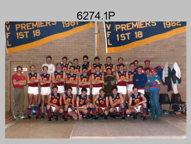
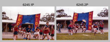
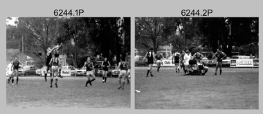
Photograph - Army Survey Regiment’s Fortuna Lions Football Club Grand Finals, Seymour, Victoria, 1983
... Army Survey Regiment...This is a set of 25 colour photographs of Army Survey...This is a set of 25 photographs of Army Survey Regiment’s...Army Survey Regiment... Survey Corps RASvy Army Survey Regiment Army Svy Regt Fortuna asr ...This is a set of 25 colour photographs of Army Survey Regiment’s Australian Rules football team – the Fortuna Lions aka “Fortuna Fumblers”, taken at Seymour Victoria in 1983. The 26th item is a A4 paper document detailing the history of Fortuna Football Club from 1978 to 1993. The Fortuna Lions competed in the Puckapunyal Area Football Association for several years from 1978 to 1984 and in 1983, fielded a great team it managed to reach the Grand Final. Held at the neutral ground at Kings Park, Seymour, the match was an incredibly exciting and bruising contest played in damp conditions and ended in a draw. Dave Lawler’s spectacular mark was a highlight. Due to heavy rain during the following week, the Grand Final replay was held the following week in even heavier conditions. The Fortuna Lions prevailed in the replay with an emphatic victory. The team’s leaders were Eddie Jacobs (coach), Rhys De Laine (captain), Greg Else (vice-captain), and Ken Slater (manager). See items 6244.27P and 6274.7P for more photographs taken at the two grand finals. Although not part of the photo collection, the team photo with names .24P and a photo of the premiership banner .25P are included. The team changed its name to the Fortuna Falcons and its guernsey to gold with a blue ‘V’ in 1988 and continued to compete in the competition up to 1995.This is a set of 25 photographs of Army Survey Regiment’s Australian Rules football team – the Fortuna Lions aka “Fortuna Fumblers”, taken at Seymour Victoria in 1983. The 26th item is a A4 paper document detailing the history of Fortuna Football Club from 1978 to 1993. The photographs were printed on photographic paper They are part of the Army Survey Regiment’s Collection. The photographs were scanned at 300 dpi and the document at 200 dpi. Fortuna’s footballers named below are in Fitzroy jumpers. .1) - Photo, colour. 1983. L to R: Nick Van Dalen, Jim Ash, Dennis Learmonth, Greg Higgins, Dave Lawler. .2) - Photo, colour. 1983. L to R: Terry McIntyre, Andy Godden, Rod Skidmore, Alan Staley, Carmel Butler, Gayle Humphrey. .3) - Photo, colour. 1983. L to R: Greg Else, Doug Home, Wendy Leitinger, Leah Hoffman, Carmel Butler, Ken Talbot-Smith. .4) - Photo, colour. 1983. L to R: Leah Hoffman, Carmel Butler, Kristin Skidmore, Neville Carr, Brian Fauth on right of banner. .5) - Photo, colour. 1983. L to R: Dave Lawler, Larry Thompson, Rod Skidmore, Greg Higgins, Gayle Humphrey. .6) and .7) - Photo, colour. 1983. Army Survey Regiment, 1st Armoured Regiment and officials line up before game. .8) - Photo, colour. 1983. L to R: unidentified (x2), Kristin Skidmore, Carmel Fauth, Leah Hoffman, Wendy Leitinger, Gayle Humphrey, Di Weston, unidentified, Rob Straube. .9) and .10) - Photo, colour. 1983. Competition’s individual award recipients. Eddie Jacobs in white shorts. .11) and .12) - Photo, colour. 1983. Fortuna’s supporters on boundary. .13) to .15) - Photo, colour. 1983. All players unidentified. .16) - Photo, colour. 1983. Dave Lawler launches to take a spectacular mark. .17) - Photo, colour. 1983. L to R: Stu Ridge (No.2) Eddie Jacobs (No.16), and (No.9). .18) - Photo, colour. 1983. L to R: unidentified (No.9), unidentified, Alan Staley (No.7). .19) - Photo, colour. 1983. L to R: Alan Staley (No.7), unidentified (No.17), unidentified, unidentified (No.9), Greg Higgins (No.20). .20) - Photo, colour. 1983. All players unidentified. .21) - Photo, colour. 1983. Peter Jones (No.5) .22) - Photo, colour. 1983. L to R: Greg Higgins (No.20), unidentified, Alan Staley (No.7). .23) - Photo, colour. 1983. L to R: Unidentified, Greg Byers (No.19). .24) - Photo, colour. 1983. Fortuna Football Club Team Photo. .25) - Banner, colour. 1983. Fortuna Football Club Premiership Banner. .26) - Document, black & white. 1993. History of Fortuna Football Club from 1978 to 1993..1P to .23P – no annotations .24P – Members of team named on bottom .26 - A4 size paper document of the team’s history.royal australian survey corps, rasvy, army survey regiment, army svy regt, fortuna, asr -
 Bendigo Military Museum
Photograph - Directors of Survey Army Headquarters, c1942-1967
... Army Survey Regiment...This is a set of two photographs of Directors of Survey...Army Survey Regiment... Australian Survey Corps RASvy Army Survey Regiment Army Svy Regt ...This is a set of two photographs of Directors of Survey Army Headquarters circa 1942 to 1967. COL Lawrence FitzGerald OBE was Director from 1942 to 1960. He received the Order of the British Empire in 1948 for his service in WW2. Although it is not known when BRIG Lawrence FitzGerald OBE was promoted to Brigadier, it is possibly an honorary promotion on his retirement in 1960. He served in the Australian Army from 03 September 1923 to 05 January 1960. COL Lawrence FitzGerald OBE was succeeded by COL Donald Macdonald AM, whose appointment to Director was from 1960 to 1967. COL Macdonald AM was promoted to Brigadier on his retirement before assuming the honorary position of Colonel Commandant of the Royal Australian Survey Corps. He served in the Australian Army from 01 January 1936 to 22 March 1960.This is a set of two photographs of Directors of Survey Army Headquarters circa 1942 to 1967.The photographs were printed on photographic paper and are part of the Army Survey Regiment’s Collection. They were scanned at 300 dpi. .1) - Photo, black and white, c1950s. D-SVY COL Lawrence FitzGerald OBE. .2) - Photo, black and white, c1960s. D-SVY COL Don Macdonald AM, MID. .1P to .2P – no annotationsroyal australian survey corps, rasvy, army survey regiment, army svy regt, fortuna, asr -
 Bendigo Military Museum
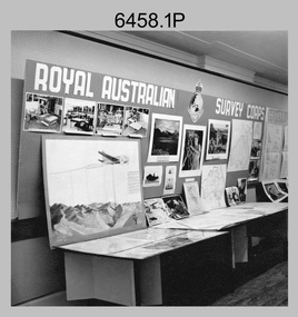
Photograph - Royal Australian Survey Corps role and technical capabilities display, c1960s
... Army Survey Regiment... of the Army Survey Regiment’s Collection. The photographs were scanned...Army Survey Regiment... Survey Corps RASvy Army Survey Regiment Army Svy Regt Fortuna ASR ...This is a collection of four photographs taken in the 1960s of Royal Australian Survey Corps displays promoting its role and technical capability to acquire, process and disseminate topographic information to the Australian Defence Force. Map products formed a large part of this topographic Support. The photos may have been taken at a Careers Expo or a Department of Defence promotion. It is possible the photos were taken at separate events. This is a collection of four photographs taken in the 1960s of Royal Australian Survey Corps displays promoting its role in Defence and technical capabilities. The black and white photographs were printed on photographic paper and are part of the Army Survey Regiment’s Collection. The photographs were scanned at 300 dpi. .1) to .4) - Photo, black & white, 1960s. Royal Australian Survey Corps Display at unknown location.There are no annotations.royal australian survey corps, rasvy, army survey regiment, army svy regt, fortuna, asr -
 Bendigo Military Museum
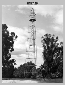
Photograph - Royal Australian Survey Corps Survey Observation Towers, c1950s
... Army Survey Regiment... and undertaking survey observations during mapping and geodetic control... paper and are part of the Army Survey Regiment’s Collection...Army Survey Regiment... Regiment Army Svy Regt Fortuna ASR surveying .1P with paper tag ...This is a set of seven photographs of Royal Australian Survey Corps surveyors setting up observation towers in the field and undertaking survey observations during mapping and geodetic control operations. c1950s. Survey observation towers were used mainly to take angular measurements in flat or heavily forested terrain, where height was necessary to achieve observer’s line-of-sight between field survey station. The Bilby Tower seen in photo .5P was erected to a height of 75 feet (23m) above ground level. The use of the Bilby Tower in Topographic Squadron’s field survey operations from 1955 to 1966 is described in page 54 of Valerie Lovejoy’s book 'Mapmakers of Fortuna – A history of the Army Survey Regiment’ ISBN: 0-646-42120-4. CAPT George Ricketts’ period of service was from 1942 to 1976 reaching the rank of LTCOL. It is noted in page 35 of Valerie Lovejoy’s book that then SGT Ricketts hand lettering skills came to the fore from his contribution to the draughting of one of the Japan’s Instruments of Surrender in 1945.This is a set of seven photographs of Royal Australian Survey Corps surveyors setting up observation towers in the field and undertaking survey observations during mapping and geodetic control operations. c1950s. The photographs were printed on photographic paper and are part of the Army Survey Regiment’s Collection. The photographs were scanned at 300 dpi. .1) - Photo, black & white, c1950s, ‘Bilby’ survey observation tower. .2) - Photo, black & white, c1950s, CAPT George Ricketts climbing ‘Bilby’ survey observation tower. .3) - Photo, black & white, c1950s, geodetic survey equipment on ‘Bilby’ survey observation tower. .4) - Photo, black & white, c1950s, two unidentified field surveyors on ‘Bilby’ survey observation tower. .5) - Photo, black & white, c1950s, two unidentified field surveyors, with CAPT Ricketts climbing ‘Bilby’ survey observation tower. .6) - Photo, black & white, c1950s, two unidentified field surveyors undertaking observations on survey observation tower. .7) - Photo, black & white, c1950, two unidentified field surveyors erecting or dismantling a survey observation tower..1P with paper tag annotated ‘Bilby Tower’ .4P on back – ‘Bilby Tower’. .5P on back – ‘Survey Observing Tower. Observing tower used for angular measurement in flat country. 75’ high – CAPT Ricketts climbing. .6P, .7P on back. ‘1960s?’royal australian survey corps, rasvy, army survey regiment, army svy regt, fortuna, asr, surveying -
 Bendigo Military Museum
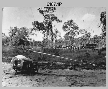
Photograph - Bell 47G-2 helicopter used in Royal Australian Survey Corps Field Operations, c1965
... Army Survey Regiment... survey unit personnel attached to the Army Survey Regiment’s... and are part of the Army Survey Regiment’s Collection. The photographs...Army Survey Regiment... survey unit personnel attached to the Army Survey Regiment’s ...This is a set of four photographs of Bell 47G-2 helicopters used in Royal Australian Survey Corps Field Operations. c1965. From 1957, helicopter transport of survey parties revolutionised transport in remote areas. The most common helicopter used by the Royal Australian Survey Corps at this time was the civilian Bell 47G-2 and the Sioux, the Australian Army’s’s equivalent. equivalent. From 1964 an Aerodist MRC2 airborne Electronic Distance Measuring (EDM) system was extensively used for topographic surveys over long distances by trilateration to replace traverse requiring survey station intervisibility. In 1965 the command field survey unit personnel attached to the Army Survey Regiment’s Topographic Squadron were used mainly in support roles such as station clearing, tower operations, station monumenting, Aerodist computations, forward base operations, geodetic observations on the north-south traverse and logistic support for Remote teams. .1P is a photo of a civilian Bell 47G-2 helicopter Registration / Serial VH-UTB owned by Helicopter Utilities from Mascot, NSW c1965. In the background of this photograph is three personnel and vehicles at a field survey camp. The left-hand vehicle is a Willys Jeep with trailer and on the right is probably a Truck, 2 1/2 ton, 6x6, General Service GMC. The Bell 47G-2: VH-UTB was destroyed, and its pilot killed in tragic circumstances during a civilian survey operation on Cape York Peninsula in June 1966. .2P is a photo of a a civilian Bell 47G-2 helicopter Registration / Serial VH-IHB taken in Wyndham, WA. As the letters ‘TAA’ appear on the fuselage, the helicopter was charted from Trans Australian Airways. .3P is a photo of a Bell 47G-2: VH-UTC with survey camp in background. .4P is a photo of a Bell 47G-2 equipped with floats and unidentified personnel loading stores, possibly in Darwin. Acknowledgement: Royal Australian Survey Corps – Aerodist Years 1964-1975 Version 2021.0 Authored by Peter Jensen.This is a set of four photographs of civilian Bell 47G-2 helicopters used in Royal Australian Survey Corps Field Operations. c1965. The photographs were printed on photographic paper and are part of the Army Survey Regiment’s Collection. The photographs were scanned at 300 dpi. .1) - Photo, black & white, c1965, Bell 47G-2 helicopter: VH-UTB with survey camp in background. .2) - Photo, black & white, c1965, Bell 47G-2 helicopter: VH-IHB with survey station in foreground. .3) - Photo, black & white, c1965, Bell 47G-2 helicopter: VH-UTC with survey camp in background. .4) - Photo, black & white, c1965, Bell 47G-2 helicopter: Unidentified personnel loading stores possibly in Darwin..2P – annotated on bottom of photo ‘Wyndham Area – Helicopter drops observing party’ The other photographs are not annotated.royal australian survey corps, rasvy, army survey regiment, army svy regt, fortuna, asr, surveying -
 Bendigo Military Museum
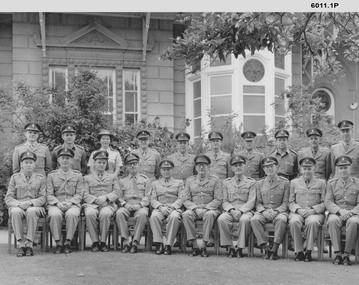
Photograph - Royal Australian Survey Corps Planning Conferences, Army Survey Regiment, Bendigo, 1962, 1964, 1966, 1967, 1972, 1973
... Army Survey Regiment.... The conferences were held at the Army Survey Regiment Fortuna Villa...Army Survey Regiment, Bendigo.... The conferences were held at the Army Survey Regiment Fortuna Villa ...The Bi Annual Planning Conferences were to plan and coordinate the activities of the Royal Australian Survey Corps. The conferences were chaired by the Director of the Survey Corps and were attended by representatives from all elements of the Corps. The conferences were held at the Army Survey Regiment Fortuna Villa Bendigo . 1) Black and white photograph of the attendees at the Royal Australian Survey Corps Planning Conference November 1964 taken outside Fortuna Villa. Conference Chairman Brigadier Don Macdonald AM, MID Director of the Survey Corps. .2) Black and white photograph of the attendees at the Royal Australian Survey Corps Biennial Planning Conference November 1966 taken at Fortuna Villa. Conference Chairman Brigadier Don Macdonald AM, MID Director of the Survey Corps. .3) Black and white photograph of the attendees at the Royal Australian Survey Corps Biennial Planning Conference November 1966 taken in the Ball Room at Fortuna Villa. Conference Chairman Brigadier Don Macdonald AM, MID Director of the Survey Corps. Conference in progress. .4) Black and white photograph of the attendees at the Royal Australian Survey Corps Planning Conference November 1967 taken outside at Fortuna Villa. Conference Chairman Brigadier Frank Buckland OBE, MID; Director of the Survey Corps. .5) Black and white photograph of the attendees at the Royal Australian Survey Corps Biennial Planning Conference 1962 taken in the gardens of Fortuna Villa. Conference Chairman COL Don Macdonald AM, MID Director of the Survey Corps. Back Row L to R: LT M. Gler, LT F. Thorogood, LT. W.A Gillard, CAPT W.P. Constantine, MAJ E.U. Anderson, MAJ. J.K. Nolan, MAJ N.R.J. Hillier, CAPT W. Greer, MAJ. M.A. Marks, LT. G. Roy. Front Row L to R: 2T F. High, MAJ C.T. Carter, MAJ T. C. Sargent, MAJ J. L. Stedman, MAJ F.D. Buckland, LTCOL C.S. Tyler, COL D. Macdonald, LTCOL W.B. Relf, MAJ H.M. Hall, MAJ L.B. Sprenger, MAJ G.H. Tomlinson, MAJ S.W. Snow. .6) Black and white photograph of the attendees at the Royal Australian Survey Corps Biennial Planning Conference c1972 taken in the gardens of Fortuna Villa. Conference Chairman COL John K. Nolan, Director of the Survey Corps. .7) Black and white photograph of the attendees at the Royal Australian Survey Corps Biennial Planning Conference 05th October 1973 taken in the gardens of Fortuna Villa. Conference Chairman COL John K. Nolan, Director of the Survey Corps. Back Row L to R: MAJ Laker, SQNLDR Porter, CAPT Clues, SQNLDR McCormack, MAJ Eddy, FLTLT O’Loghlin, MAJ Illingworth, MAK Laing, MAJ Thorogood, MAJ Millar, CAPT Mason. Front Row L to R: MAJ Taylor, MAJ Ricketts, LTCOL Anderson, WGCOMD Whitely, LTCOL Ridge, MAJ Dalton, MAJ Todd..1 Nov 64 written on back, .2 RA Svy - Biennial Conference Nov 66 annotated on front, .3 Biennial Conference Nov 66 annotated on back, .4 RA Svy Planning Conference - Nov 67 annotated on front, .5 All officers annotated at footnotes on front, 6. No annotations, 7. All officers annotated on back and dated 5 Oct 73royal australian survey corps, rasvy, fortuna, army survey regiment, army svy regt, asr -
 Bendigo Military Museum
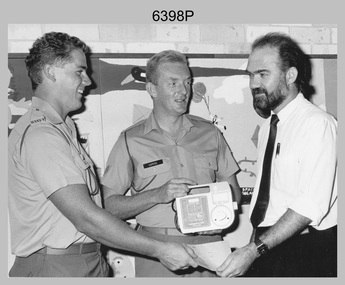
Photograph - 2 FD Svy Sqn Childrens Hospital Charity Presentation, Sydney, NSW, 1989
... Army Survey Regiment... was printed on photographic paper and is part of the Army Survey...Army Survey Regiment, Bendigo.... Royal Australian Survey Corps RASvy Army Survey Regiment Army ...This photograph of a charity donation from 2 FD Svy Sqn to the Director of the Prince of Wales Childrens Hospital, was taken in Sydney in 1989. CPL Bob Hopper and SPR Bob White presented a Kangaroo Pump, used for feeding sick children to the Director that was purchased with leftover Regimental funds when the unit closed down. This photograph of a charity donation from member of 2 FD Svy Sqn to the Director of the Prince of Wales Childrens Hospital was taken in Sydney in 1989. The black & white photograph was printed on photographic paper and is part of the Army Survey Regiment’s Collection. The photograph was scanned at 300 dpi. .1) - Photo, black & white, 1989. L to R: SPR Bob White, CPL Bob Hopper, Director of the Prince of Wales Childrens Hospital..1P – annotated in red pen ‘2 Fd, presenting the Director of the Prince of Wales Childrens’ Hospital with a Kangaroo Pump, used for feeding sick children. The pump was purchased with leftover Regimental funds when the unit closed down.’royal australian survey corps, rasvy, army survey regiment, army svy regt, 2 fd svy sqn -
 Bendigo Military Museum
Photograph - Royal Australian Survey Corps Surveyors in the Field – Project Cutlass, New Guinea, 1956 – 1957
... Army Survey Regiment... last appointment was the CO of the Army Survey Regiment from... Survey Regiment’s Collection. The photographs were scanned at 300...Army Survey Regiment... last appointment was the CO of the Army Survey Regiment from ...This is a set of 23 photographs of surveyors and support staff in the field undertaking tasks in New Guinea 1956 – 1957. The surveyors were employed in the establishment of mapping and geodetic control for Project Cutlass, the “Ship-Shore” survey of the New Ireland province. In this survey operation surveyors used theodolites to observe horizontal and vertical angles and chains to measure base line distances between survey stations. Bob Skitch shown in photo .7P was in the 2nd year of his career in the Australian Army. He achieved the rank of Lieutenant-Colonel, and his last appointment was the CO of the Army Survey Regiment from 1976 to 1980.This is a set of 23 photographs of surveyors and support staff in the field undertaking duties during Project Cutlass located in New Ireland, New Guinea 1956 – 1957. The photographs were printed on photographic paper and are part of the Army Survey Regiment’s Collection. The photographs were scanned at 300 dpi. .1) - Photo, colour, 1956. Surveyors travelling main road from Kavieng to Namatanai, New Ireland. .2) - Photo, colour, 1956. Unidentified surveyors assessing recovery of their vehicle after bridge collapsed on west side of New Ireland. .3) - Photo, colour, 1956. Unidentified surveyors assessing recovery of their vehicle after bridge collapsed over flooded creek on west side of New Ireland. .4) - Photo, colour, 1956. Survey personnel L to R: Bev Uwins, John Lambie, Bob Thompson, New Ireland. .5) - Photo, colour, 1956. Survey base camp, New Ireland. .6) - Photo, black & white, 1956-1957. Geoff Helsham with possible human remains, New Ireland. .7) - Photo, black & white, 1956-1957. Bob Skitch undertaking survey observations using Wild T2 theodolite, New Ireland. .8) - Photo, black & white, 1956-1957. Chas Beach undertaking survey observations using Wild T2 theodolite, New Ireland. .9) & .10) - Photo, black & white, 1956-1957. Kev Parker (cook) New Ireland. .11) - Photo, colour, 1957. Brian Berkery taking a break, Top Manor Island, Lihir Island Group off New Ireland. Latitude -2° 46”, Longitude 152° 40”. .12) - Photo, colour, 1957. Survey base camp L to R: Chas Beach, Bev Uwins, Feni Islands, New Ireland. Latitude -4° 05”, Longitude 153° 45”. .13) - Photo, colour, 1957. A Hous Kiap. (Kiaps, known formally as district officers and patrol officers, were travelling representatives of the British and Australian governments), New Ireland. .14) & .15) - Photo, colour, 1957. L to R: Joe Farrington, Tom Royle Bob undertaking survey observations using theodolites from an improvised timber tower, New Ireland. .16) & .17) - Photo, colour, 1957. US Army ship FS216 used for ship-to-shore triangulation docked at Rabaul, New Britain. .18) - Photo, colour, 1957. US Army ship FS216 used for ship-to-shore triangulation docked at Kavieng, New Ireland. Sight target on top of mast. .19) - Photo, colour, 1957. Survey personnel onboard US Army ship FS392, L to R: Peter Frodsham, Bob Thompson, Doc Reid, John Underwood, remainder unidentified, New Ireland. .20) - Photo, colour, 1957. Survey base line party heading ashore, New Ireland. .21) - Photo, colour, 1957. Survey personnel rowing US Army assault boat L to R: Kev Parker, Chas Beach, folded up survey beacons overhanging stern, New Ireland. .22) - Photo, colour, 1957. Les Bailey onboard US Army ship departing Rabaul, New Britain for Brisbane. .23) - Photo, colour, 1957. Ron Newman onboard US Army ship departing Rabaul, New Britain for Brisbane. Active volcano in background..1P to .23P annotated on back – ‘Operation Cutlass’, personnel names, the year and the location. royal australian survey corps, rasvy, army survey regiment, fortuna, a, army svy regt, asr, surveying -
 Bendigo Military Museum
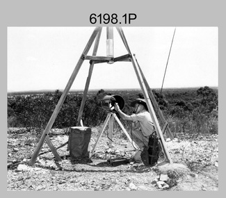
Photograph - Royal Australian Survey Corps Electronic Distance Measuring Equipment Demonstration, c1960s
... Army Survey Regiment... on photographic paper and are part of the Army Survey Regiment’s...Army Survey Regiment.... Royal Australian Survey Corps RASvy Army Survey Regiment Army ...This is a set of five photographs of CAPT James ‘Jim’ Leslie Stedman in the field demonstrating the setup of prisms used as electric distance measurement (EDM) receiver reflectors for tellurometer equipment and the sighting of a large surveyor’s light. This equipment was deployed in establishing mapping and geodetic control operations. The photos were most likely taken in the late 1950s or early 1960s. The tellurometers of this era were man-portable systems that improved geodetic survey efficiencies for rapid network extension and densification replacing triangulation with EDM and theodolite traverse sometimes using Bilby Towers to extend line lengths. Jim Stedman later reached the rank of Colonel, was Director of Military Survey from 1975 to 1978 and was appointed as Colonel Commandant (honorary appointment, Retd) of the Royal Australian Survey Corps from 1978 to 1983. Jim Stedman is demonstrating EDM equipment. See item 6180.16P, photos .14) to .16) for more information and photos of Jim Stedman’s EDM demonstration. This is a set of five photographs of a surveyor in the field demonstrating electric distance measurement (EDM) equipment. c1950s – 1960s. The photographs were printed on photographic paper and are part of the Army Survey Regiment’s Collection. The photographs were scanned at 300 dpi. .1) to .2) - Photo, black & white, c1960s, CAPT Jim Stedman demonstrating the sighting of a large surveyor’s light. .3) to .5) – Photo, black & white, c1960s, CAPT Jim Stedman demonstrating EDM prism equipment. .1P to .5P on back – CAPT Stedman EDM Eqpt.royal australian survey corps, rasvy, army survey regiment, army svy regt, fortuna, asr, surveying -
 Bendigo Military Museum
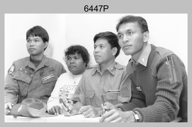
Photograph - Defence Co-operation Project Students, School of Military Survey, Bonegilla, VIC, 1990
... Army Survey Regiment... Survey Regiment’s Collection. The photograph was scanned at 300...Army Survey Regiment... Australian Survey Corps RASvy Army Survey Regiment Army Svy Regt ...This is a photograph of Defence Co-operation Project (DCP) students from the Pacific region who attended the 1/90 Specialist Carto course held at the School of Military Survey, Bonegilla, Victoria from the 9th of May to the 5th of June 1990.This is a photograph of Defence Co-operation Project (DCP) students attending the 1/90 Specialist Carto course held at the School of Military Survey, Bonegilla, Victoria in 1990. The photograph was printed on photographic paper and is part of the Army Survey Regiment’s Collection. The photograph was scanned at 300 dpi. .1) - Photo, black & white, 1990, DCP Students L to R: SGT Ramos – Philippines, Miss Chukeni – Solomon Islands, SGT Laguador – Philippines, CPL Jais – Malaysia. .1P – Students, course title and date annotated on back of photo.royal australian survey corps, rasvy, army survey regiment, army svy regt, school of military survey, fortuna, asr -
 Bendigo Military Museum
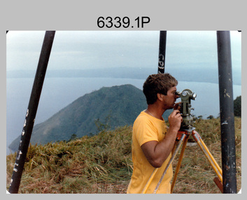
Photograph - Royal Australian Survey Corps personnel on survey operations in PNG and possibly Indonesia, c1975
... Army Survey Regiment... on photographic paper and are part of the Army Survey Regiment’s...Army Survey Regiment... RASvy Army Survey Regiment Army Svy Regt Fortuna ASR .1P and .2P ...This is a set of two photographs of Royal Australian Survey Corps and RAAF personnel on survey operations in PNG and possibly Indonesia circa 1975. The identified surveyor - Peter Presser served 20 years in the Australian Regular Army from 1970 to 1990. The UH-1H Iroquois helicopter (serial number partially obscured) appearing in photo 6339.2P was probably A2-379. From 1957 helicopter transport of survey parties revolutionised transport in remote areas. The most common helicopter used by the Royal Australian Survey Corps (RA Svy) up to 1972 was the civilian Bell 47G-2 and the Sioux Light Observation Helicopters (LOH), the Australian Army’s equivalent. These light observation helicopters had a limiting load carrying capacity of up to about 500 pounds. By comparison, one Aerodist team including two people weighed up to 1,500 pounds. After No. 9 Squadron (9SQN) RAAF (Iroquois helicopters) withdrew with the Australian force from Vietnam in December 1971, RAAF supported RA Svy operations with the UH-1H Iroquois helicopter for tasks of transport and resupply of survey teams. The UH-1H was capable of carrying at least three times that of the smaller Bell 47G-2/Sioux LOH helicopter and could also winch personnel and stores into difficult locations. A2-379 crashed killing the aircraft captain (FLTLT Ralph Taylor 9SQN) on impact and seriously injuring four near Wamena, Irian Jaya, Indonesia on survey Operation Cenderawasih 1977 (supporting 2 Fd Svy Sqn – Doppler satellite survey). Source: Royal Australian Survey Corps – Aerodist Years 1964-1975 by Peter Jensen.This is a set of two photographs of Royal Australian Survey Corps and RAAF personnel on survey operations in PNG and possibly Indonesia circa 1975. The photographs were printed on photographic paper and are part of the Army Survey Regiment’s Collection. The photographs were scanned at 300 dpi. .1) - Colour, black & white, c1975, Peter Presser undertaking survey observations in PNG with a Wild T2 Theodolite. .2) - Photo, black & white, c1975. Survey operations L to R: unidentified (x2), Peter Presser, unidentified. .1P and .2P – No annotations. royal australian survey corps, rasvy, army survey regiment, army svy regt, fortuna, asr -
 Bendigo Military Museum
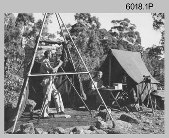
Photograph - Royal Australian Survey Corps Surveyors in the Field, Army Survey Regiment, 1950s to 1970s
... Army Survey Regiment... printed on photographic paper and are part of the Army Survey...Army Survey Regiment... Survey Regiment Army Svy Regt Fortuna ASR surveying .1 ...These three photographs were most likely taken from the 1950s to the 1970s. The RASvy surveyor in each photograph was taking angular measurements with the observer recording their readings on a booking form. They were probably employed in establishing mapping and geodetic control operations or the surveyors may have been in training. Photo .1P was possibly taken at Mount Alexander in Central Victoria, a location close to Bendigo, as the stone cairn in the background of the photo appears to be identical to the cairn presently located on top of the mountain. Personnel and location have been confirmed on another photo in the collection with annotation. These three photographs are of surveyors in the field undertaking observations using theodolites. The photographs were printed on photographic paper and are part of the Army Survey Regiment’s Collection. The photographs were scanned at 300 dpi. .1) - Photo, black & white, c1950s. Unidentified personnel undertaking observations with a Tavistock geodetic theodolite. .2) – Photo, colour, mounted on card, c1960s. Unidentified personnel undertaking observations with a Kern DKM2 theodolite. .3) - Photo, colour, c1970s. Unidentified personnel undertaking observations with a theodolite..1 – not annotated .2 –annotated on front “Kern DKM2, TOPO 10” royal australian survey corps, rasvy, army survey regiment, army svy regt, fortuna, asr, surveying -
 Bendigo Military Museum
Poster - Map Production flow chart poster using Automap 2, Army Survey Regiment, Bendigo, 1982
... Army Survey Regiment... System at the Army Survey Regiment, Bendigo....Army Survey Regiment, Bendigo... Survey Regiment, Bendigo ...This poster designed to be folded into a brochure describes the second phase of the computer assisted cartographic system to be used by the Royal Australian Survey Corps in the establishment of a topographic data base, Future tactical applications and map products using the data base are displayed. A topographic map of Series R631 1:100,000 Helenvale, Queensland printed on the reverse side that was produced by the Automap system using information from the topographic data base. This is the fifth edition of the poster.A multi colour poster of map production using the Automap 2 system. Poster shows a schematic and pictorial flow chart diagram of the stages of the map production process using the Automap 2 system. The poster was intended to be folded into a small brochure. A 1:100,000 Army Survey Map Series R631, 7966 Helenvale, Queensland Edition 2 is printed on the reverse side of the poster. The map is an example of one of the initial maps produced on the Automap 2 System at the Army Survey Regiment, Bendigo.royal australian survey corps, rasvy, fortuna, army survey regiment, army svy regt, asr, automap 2 -
 Bendigo Military Museum
photograph - Royal Australian Survey Corps Aero-triangulation Equipment, 1936 to 1952
... Army Survey Regiment... printed on photographic paper and are part of the Army Survey...Army Survey Regiment... Regiment Army Svy Regt Fortuna ASR air survey aerotrig .1 and .2 ...Although it’s unknown when these two photos were taken, the South African Pattern Mk IV Slotted Template Machine was in service from 1936 to 1952. The machine was used to cut slots and holes in an acetate film medium. This template was then used to fit several runs of aerial photography to ground control points at a desired scale with a substitution of the templates in the assembly. Radial slots on the templates from central holes representing the photograph’s principal point (centre) were placed over hollow metal studs mounted over control points on the scaled base sheet. The studs represented the intersection of radial lines through common points of detail of overlapping photos. A pricker was used to transfer from the photo-points to the templates. The slotted template methodology was later used as an essential aero-triangulation exercise in advance courses conducted at the School of Military Survey.These three photographs are of a slotted template machine used in aero-triangulation. The first two photographs were printed on photographic paper and are part of the Army Survey Regiment’s Collection. The photographs were scanned at 300 dpi. The third photograph was captured from a collection using a smart phone. .1) and .2) - Photo, black & white, 1936-1952. South African Pattern Mk IV Slotted Template Machine. .3) - Photo, black & white, 1936-1952. WO2 Bob Pratt operating the Slotted Template Machine. .1 and .2 –annotated on back “Slotted Template” .3P - annotated on front “COMPILATION SECTION SLOTTED TEMPLATE MACHINE WO2 BOB PRATT”royal australian survey corps, rasvy, army survey regiment, army svy regt, fortuna, asr, air survey, aerotrig -
 Bendigo Military Museum
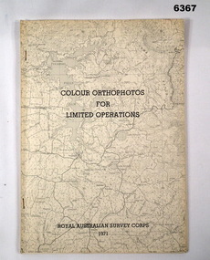
Administrative record - Royal Australian Survey Corps - Colour Orthophotos for Limited Operations 1971, Army Survey Regiment, Bendigo, 1971
... Army Survey Regiment... (Puckapunyal area) during 1971 conducted at the Army Survey Regiment...Army Survey Regiment, Bendigo... (Puckapunyal area) during 1971 conducted at the Army Survey Regiment ...This is a report on the experimental production of the colour Orthophoto Map 1:25,000 7924 - 3 - SW Northwood (Puckapunyal area) during 1971 conducted at the Army Survey Regiment Bendigo. The report covers all aspects of production including cartographic enhancement, test proofing, platemaking and printing. While Annexes A and C are listed in the contents, they are missing from the document. A second copy has been added to this record that contains Annex A that is a colour enhanced colour orthohotomap of the map sheet.Soft covered A4 sized booklet stapled along the left hand side. Title and a greyed map image printed on cover. A second copy containing Annex A was added in 2025royal australian survey corps, rasvy, fortuna, army survey regiment, army svy regt, asr -
 Bendigo Military Museum
Photograph - Army Survey Regiment’s Fortuna Lions Football Club Grand Finals, Seymour, Victoria, 1983
... Army Survey Regiment... Survey Regiment’s Australian Rules football team – the Fortuna... Survey Regiment’s Australian Rules football team – the Fortuna...Army Survey Regiment... Survey Regiment’s Australian Rules football team – the Fortuna ...This is a set of 27 black & white photographs of Army Survey Regiment’s Australian Rules football team – the Fortuna Lions aka “Fortuna Fumblers”, taken at Seymour Victoria in 1983. The Fortuna Lions competed in the Puckapunyal Area Football Association for several years from 1978 to 1984 and in 1983, fielded a great team it managed to reach the Grand Final. Held at the neutral ground at Kings Park, Seymour, the match was an incredibly exciting and bruising contest played in damp conditions and ended in a draw. Dave Lawler’s spectacular mark was a highlight. Due to heavy rain during the following week, the Grand Final replay was held the following week in even heavier conditions. The Fortuna Lions prevailed in the replay with an emphatic victory. The team’s leaders were Eddie Jacobs (coach), Rhys De Laine (captain), Greg Else (vice-captain), and Ken Slater (manager). See item 6274.7P for more photographs taken at the two grand finals, team photo. See item 6245.26P for colour photos of the finals, the team photo with names and a photo of the premiership banner. The team changed its name to the Fortuna Falcons and its guernsey to gold with a blue ‘V’ in 1988 and continued to compete in the competition up to 1995. This is a set of 27 black and white photographs of Army Survey Regiment’s Australian Rules football team – the Fortuna Lions aka “Fortuna Fumblers”, taken at Seymour Victoria in 1983. The photographs were printed on photographic paper and are part of the Army Survey Regiment’s Collection. The photographs were scanned at 300 dpi. Players named below are in Fitzroy jumpers. .1) - Photo, black and white. 1983. L to R: Mick Hogan, Peter Jones (ruck), Rod Skidmore (No.14), Greg Else, Stu Ridge (No.2). .2) - Photo, black and white. 1983. L to R: Rhys De Laine, Doug Home, Mick Hogan (no.12), Rod Skidmore. .3) - Photo, black and white. 1983. L to R: unidentified (x2), Keith Quinton, Doug Home, Mick Hogan. .4) - Photo, black and white. 1983. L to R: Rod Skidmore, Greg Byers, Rhys De Laine, Rhys De Laine, Jim Ash. .5) - Photo, black and white. 1983. L to R: Stu Ridge (No.2) Peter Jones (ruck No.5), Mick Hogan. .6) - Photo, black and white. 1983. L to R: Keith Quinton (No.3), unidentified (No.8), Dennis Learmonth, Greg Byers. .7) - Photo, black and white. 1983. L to R: Greg Byers, Greg Higgins, Stu Ridge, Dennis Learmonth (No.10), Keith Quinton. .8) - Photo, black and white. 1983. L to R: Bob Thrower (No.21), Peter Jones, Dennis Learmonth (No.10). .9) - Photo, black and white. 1983. L to R: all unidentified. .10) - Photo, black and white. 1983. L to R: Mick Hogan (no.12), Doug Home, Peter Jones (No.5), Greg Else, Jim Ash. .11) - Photo, black and white. 1983. L to R: Dennis Learmonth, Keith Quinton. .12) - Photo, black and white. 1983. L to R: unidentified, Eddie Jacobs (No.16), Greg Higgins (No.20). .13) - Photo, black and white. 1983. L to R: all unidentified. .14) - Photo, black and white. 1983. L to R: Rod Skidmore, Jim Ash. .15) - Photo, black and white. 1983. L to R: Greg Else (No.6), Mick Hogan (No.12), Alan Staley, unidentified. .16) - Photo, black and white. 1983. L to R: unidentified, Peter Jones, Rhys De Laine. .17) - Photo, black and white. 1983. L to R: Eddie Jacobs, Greg Else. .18) - Photo, black and white. 1983. L to R: Keith Quinton (No.3), Rod Skidmore, Eddie Jacobs, Dave Lawler. .19) - Photo, black and white. 1983. L to R: Doug Home, Greg Byers, Bob Thrower, Rod Skidmore, unidentified. .20) - Photo, black and white. 1983. L to R: Stu Ridge (No.2), Greg Higgins (No.20), unidentified (No.8). .21) - Photo, black and white. 1983. L to R: all unidentified. .22) - Photo, black and white. 1983. L to R: Peter Jones (no.5), Greg Byers (No.19), unidentified (x2). .23) - Photo, black and white. 1983. L to R: unidentified. .24) - Photo, black and white. 1983. L to R: Mick Hogan, unidentified (no.13), Rhys De Laine, Jim Ash, Keith Quinton (No.3). .25) - Photo, black and white. 1983. L to R: Steve Burke, Peter Dillon, Jim Ash, Dave Lawler, Paul Baker, Tracy Ash, unidentified, Warren Hall. In far-right background: Greg Else, Megan Reynolds. .26) - Photo, black and white. 1983. L to R: Warren Hall, Ken Slater, Cliff Webb, shirtless Glen Cannon. .27) - Photo, black and white. 1983. L to R: Warren Hall, unidentified..1P to .27P – no annotationsroyal australian survey corps, rasvy, army survey regiment, army svy regt, fortuna, asr -
 Bendigo Military Museum
Photograph - A Section, 1st Topographic Survey Troop, Vung Tau, Vietnam, 1966
... Army Survey Regiment... and the Army Survey Regiment’s supporting role is provided in pages 89... and are part of the Army Survey Regiment’s Collection. The photographs...Army Survey Regiment, Bendigo... and the Army Survey Regiment’s supporting role is provided in pages 89 ...This is a set of 12 photographs of A Section, 1st Topographic Survey Troop taken from the 25th of May to the 12th of June 1966 during their deployment to Vung Tau, Vietnam. Led by OC CAPT Bob Skitch, the ten personnel from A Section 1st Topo Svy Tp and six personnel from supporting units were the first contingent from the Royal Australian Survey Corps deployed to provide topographic support to the Australian Task Force in Vietnam. They arrived in Saigon, Vietnam on the 10th of June 1966 enroute to the Australian Reinforcement Unit (ARU) “back beach” camp in Vung Tau. The ten RA Svy technical personnel from 1st Topo Svy Tp deployed were: WO2 David Christie, SGT Stan Campbell, SGT Dave King, CPL Jim Roberts, CPL Dennis Duquemin, CPL Des Ceruti, SPR Derek Chambers, SPR Brian Firns, SPR Joe O’Connor and SPR Ron Smith. External personnel deployed were: WO2 Snow Rollston from Northern Command Field Survey Unit, T/CPL Peter Clarke – orderly room corporal, T/CPL Alan Carew – Technical Storeman, SPR Stan Johns – Map Storeman, SPR Boots Campbell – batman/driver and PTE BNF Brunning – cook. The ship featured in photos .1P and .2P was the aircraft carrier HMAS Sydney on its 4th voyage to Vietnam. On board were SGT Stan Campbell and SPR Brian Firns, tasked to manage A Section’s stores and equipment. The rest of A Section deployed to Vietnam by air on the chartered Qantas 707B ‘City of Longreach'. A Section’s main tasks were to establish a Theatre Grid, map compilation and map revision; Engineer Survey Support in the camp and to the civil community; give assistance to the Cordon Search Missions by producing large scale plots from aerial photos with every house and fence etc plotted; and then reproduce these by silk screening usually, within a 24-hour period. RA Svy’s support concluded with the withdrawal of Australian troops from Vietnam in 1972. More information on the A Section, 1st Topographic Survey Troop and the Army Survey Regiment’s supporting role is provided in pages 89 to 94 of Valerie Lovejoy’s book 'Mapmakers of Fortuna – A history of the Army Survey Regiment’ ISBN: 0-646-42120-4.This is a set of 12 photographs of A Section, 1st Topographic Survey Troop (1st Topo Svy Tp), taken from the 25th of May to the 12th of June 1966 during their deployment to Vung Tau, Vietnam. The black and white photographs were printed on photographic paper and are part of the Army Survey Regiment’s Collection. The photographs were scanned at 300 dpi. .1) &.2) - Photo, black & white, 1966. HMAS Sydney departing Woolloomooloo wharf en-route to Vietnam. .3) - Photo, black & white, 1966. A Section 1 Topo Svy Tp relaxing in a bar before deployment. OC CAPT Bob Skitch in centre of photo. .4) - Photo, black & white, 1966. Unidentified A Section 1 Topo Svy Tp personnel and troops from other units relaxing in a bar before deployment. .5) - Photo, black & white, 1966. A Section 1 Topo Svy Tp personnel arrival by bus at Saigon (Tan Son Nhut) Airport. OC CAPT Bob Skitch 4th from right. .6) - Photo, black & white, 1966. A Section 1 Topo Svy Tp personnel boarding the USAF Hercules aircraft enroute from Saigon (Tan Son Nhut) Airport to Vung Tau Airfield. OC CAPT Bob Skitch on left. .7) - Photo, black & white, 1966. A Section 1 Topo Svy Tp personnel and troops from other units boarding the USAF Hercules aircraft enroute from Saigon (Tan Son Nhut) Airport to Vung Tau Airfield. .8) & .9) - Photo, black & white, 1966. A Section 1 Topo Svy Tp personnel arrive at the Australian Reinforcement Unit (ARU) “back beach” camp. .10) - Photo, black & white, 1966. A Section 1 Topo Svy Tp personnel in oppressive conditions work on map products. .11) - Photo, black & white, 1966. Group photo of A Section 1 Topo Svy Tp. OC CAPT Bob Skitch on far right. .12) - Photo, black & white, 1966. Group photo of A Section 1 Topo Svy Tp. OC CAPT Bob Skitch 3rd from right.Annotated with the photo set - ‘ DET 1 Topo Svy Tp Vung Tau 25 May to 12 of Jun 66’royal australian survey corps, rasvy, army survey regiment, army svy regt, fortuna, asr, 1st topographical survey troop